
Wargame Simulation Theory and Evaluation Method for Emergency Evacuation of Residents from Urban Waterlogging Disaster Area


Abstract
:1. Introduction
2. Materials and Methods
2.1. Wargame Theories for Emergency Evacuation
2.2. Wargame Principles for Waterlogging Disaster Evacuation
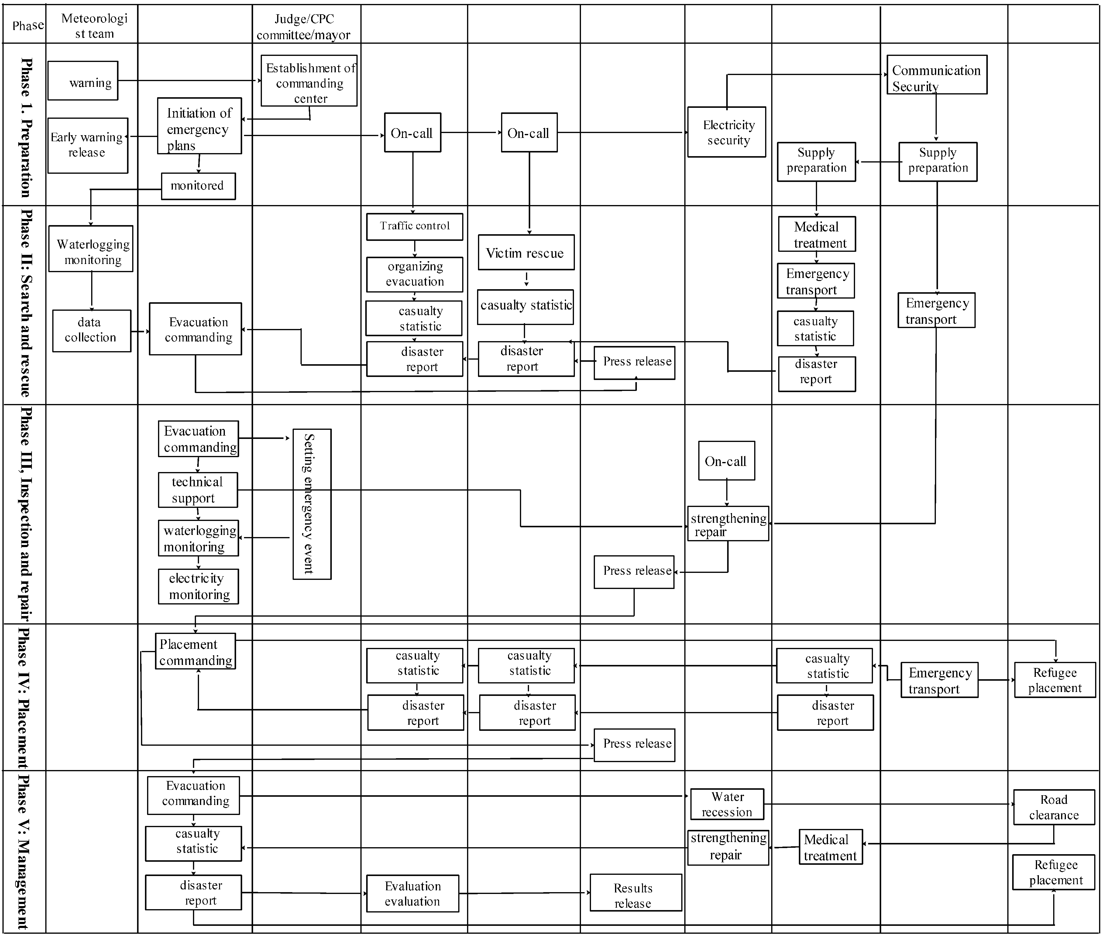
2.3. Contents and Procedure of Wargame for Urban Waterlogging and Evacuation
2.4. Rules and Evaluation Methods for Wargames Used for Evacuation of Residents Affected by Urban Waterlogging Disaster
2.4.1. Deduction Rules
2.4.2. Evaluation Method
2.5. Developing Approaches for the Regulation of Wargame
2.5.1. Rainstorm Regulation
- According to the formula (CHM), the total precipitation in t time was calculated:where is the average precipitation intensity in t time. a, b and c are constants.
- Instantaneous precipitation intensity in t moment is deduced from differentiation of H.
- r, the peak value ranges from 0.3 to 0.5 of precipitation intensity, is the actual rainfall events. The t is calculated as follows:where is the duration of rainfall before the peak value, the same as after the peak value.
- Formula (5) is added to Formula (4):
- Referring to the rainstorm intensity formula:where p is the return period (as shown in Table 2), t is the duration of rainfall whose unit is hand q is the rainstorm intensity with the unit L/(S·hm2), respectively.
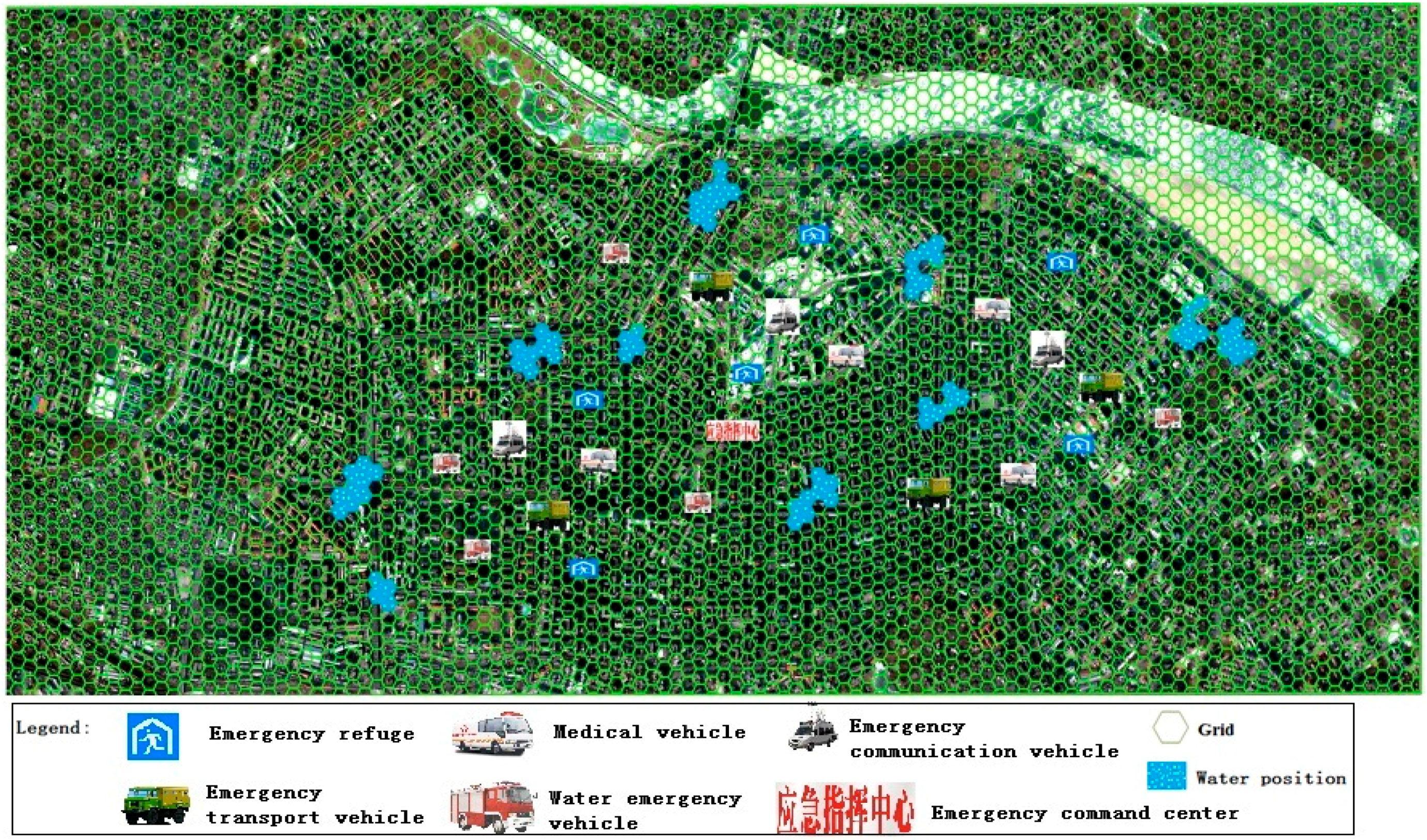
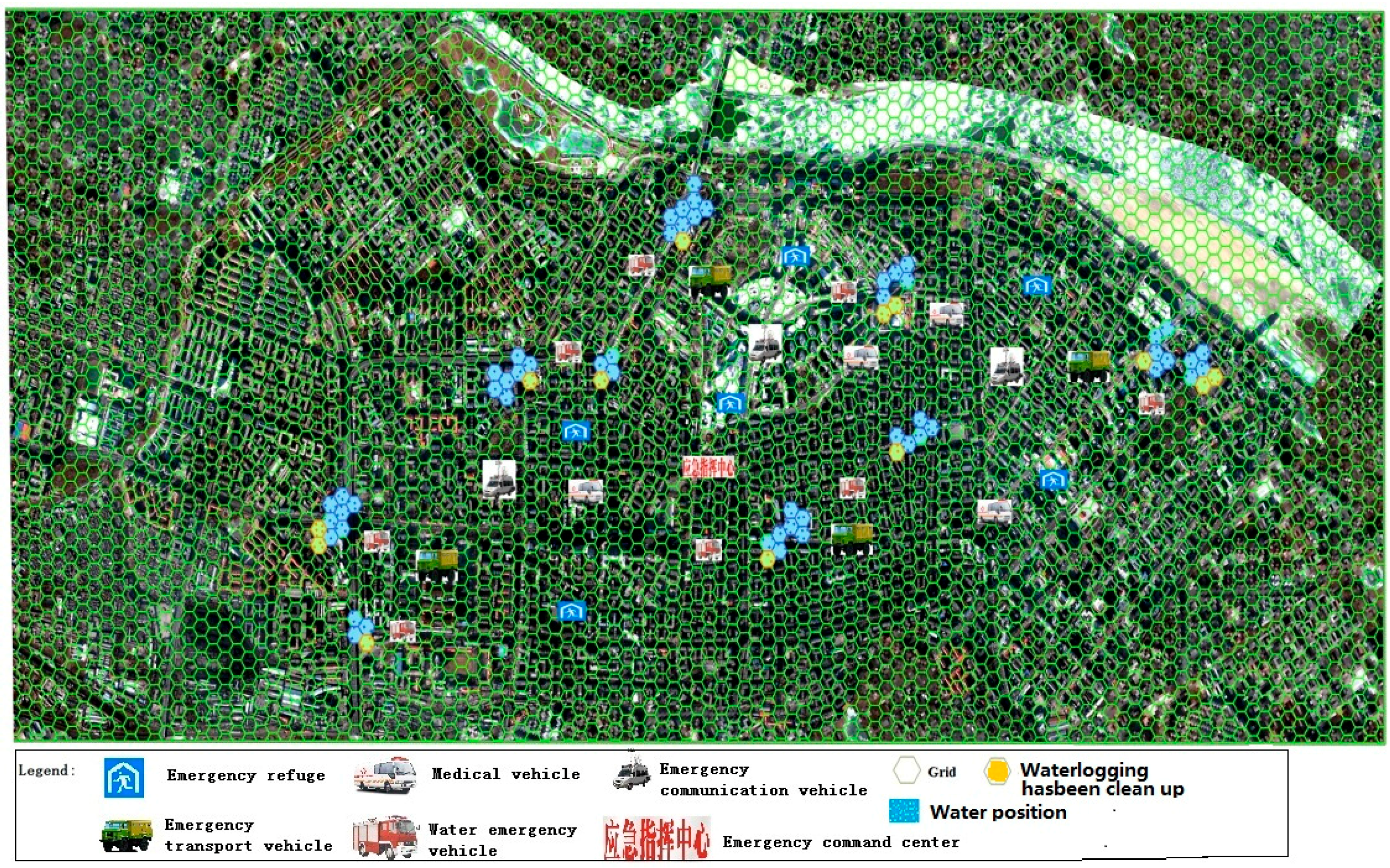
2.5.2. The Simulation Method of the Wargame
3. Results
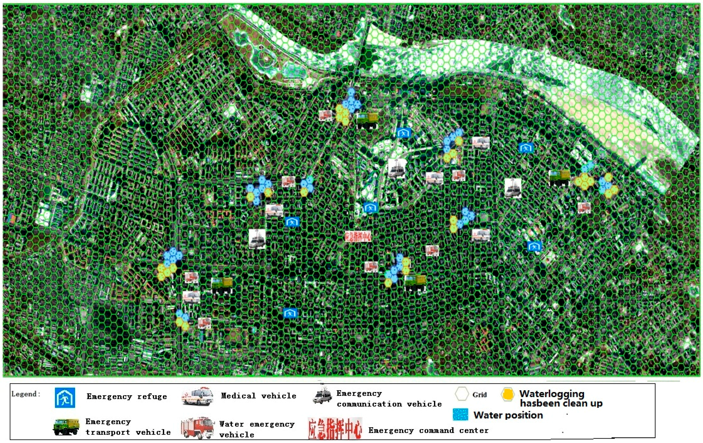
3.1. Preparation Phase Simulation
3.2. Search and Rescue Phase Simulation
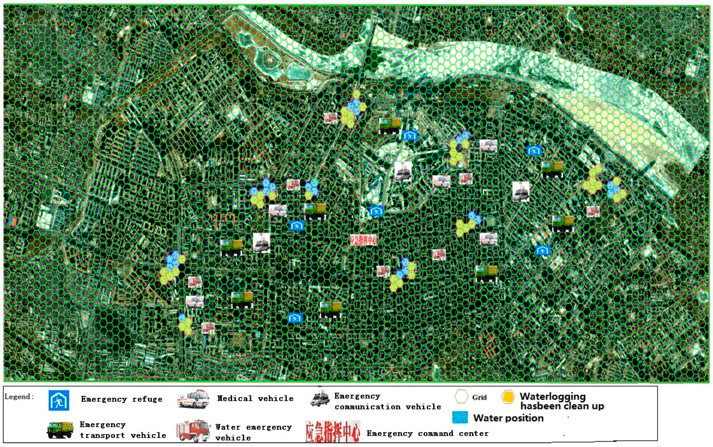
3.3. Reinforcing Repair Phase Simulation
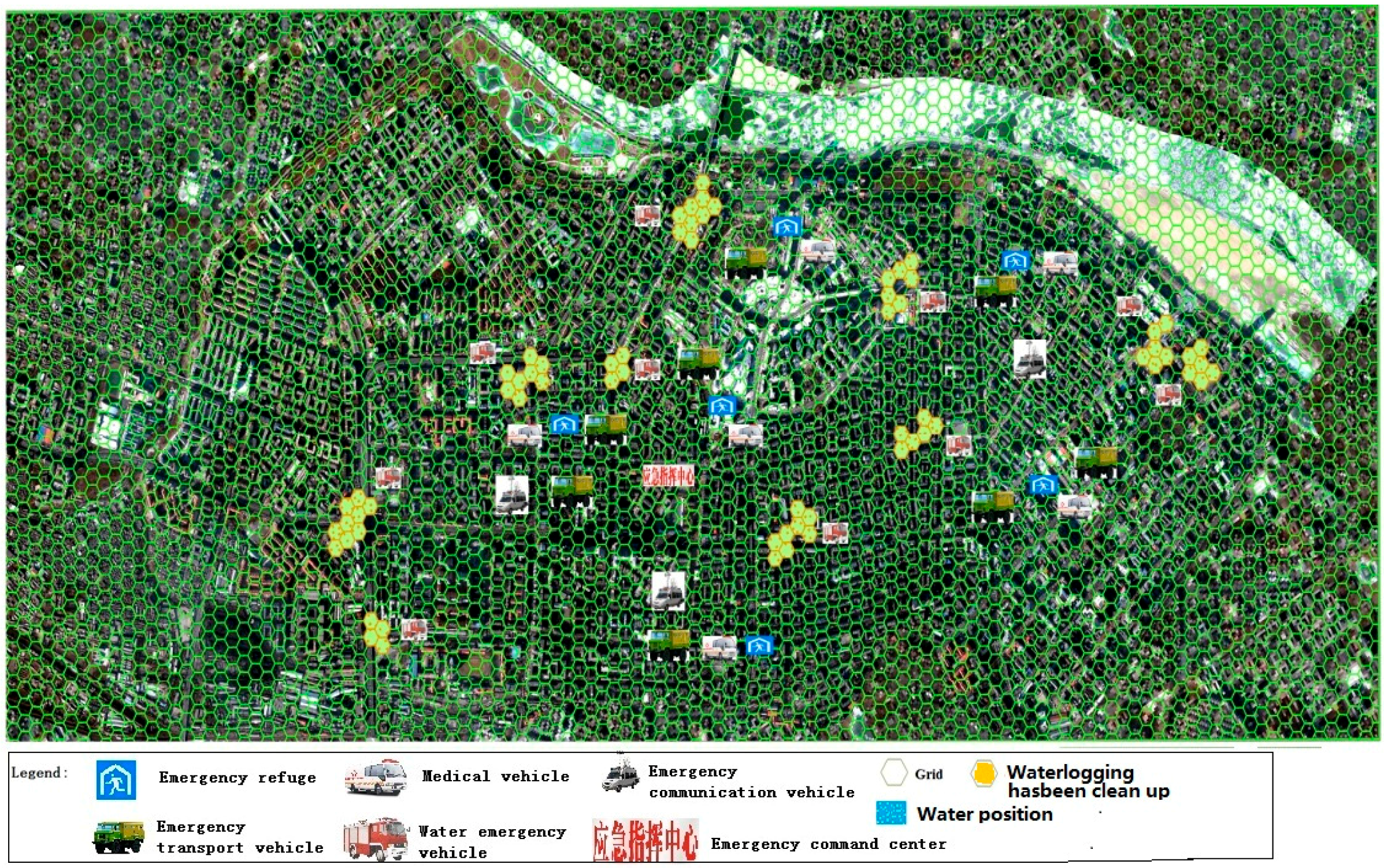
3.4. Placement Phase Simulation
3.5. Management Phase Simulation
4. Discussion
5. Conclusions
Acknowledgments
Author Contributions
Conflicts of Interest
References
- Ye, L.; Gong, L.; Liu, Z. Research and Modeling of a Rehearsal System of Naval Battle. Comput. Digit. Eng. 2011, 39, 58–61. (In Chinese) [Google Scholar]
- Shi, C.; Liu, B. Research on the Rehearsal & Evaluation System Based on Simulation. Tactical Missile Technol. March 2012, 1, 122–124. (In Chinese) [Google Scholar]
- Kong, W. The ADMS disaster management simulation system. Mod. Occup. Saf. 2011, 11, 107–108. (In Chinese) [Google Scholar]
- Darken, R.; McDowell, P.; Johnson, E. Projects in VR: The Delta3D open source game engine. IEEE Comput. Graph. Appl. 2005, 25, 10–12. [Google Scholar] [CrossRef] [PubMed]
- Li, Y.; Yao, F. Confrontational CISR simulation training system based on high level architecture. Command Inf. Syst. Technol. 2012, 3, 5–7. (In Chinese) [Google Scholar]
- Li, J.; Ji, Z. The design and implementation of “AKY-MCP” a mobile major accidents monitoring and command platform. J. Saf. Sci. Technol. 2009, 5, 77–80. (In Chinese) [Google Scholar]
- Chen, M.; Jiang, B.; Li, L. The design of urban emergency management system base on the Wargame theory. Chin. J. Environ. Manag. 2014, 6, 38–42. (In Chinese) [Google Scholar]
- Li, Q. Analysis and design of simulated emergency exercise system platform. J. Saf. Sci. Technol. 2012, 3, 026. (In Chinese) [Google Scholar]
- Ma, Y.; Zhang, X.; Ma, Y.; Lian, D.; Sun, Y. Emergency Drills Program Dynamic Deduction System. Comput Syst Appl. 2013, 2, 64–67. (In Chinese) [Google Scholar]
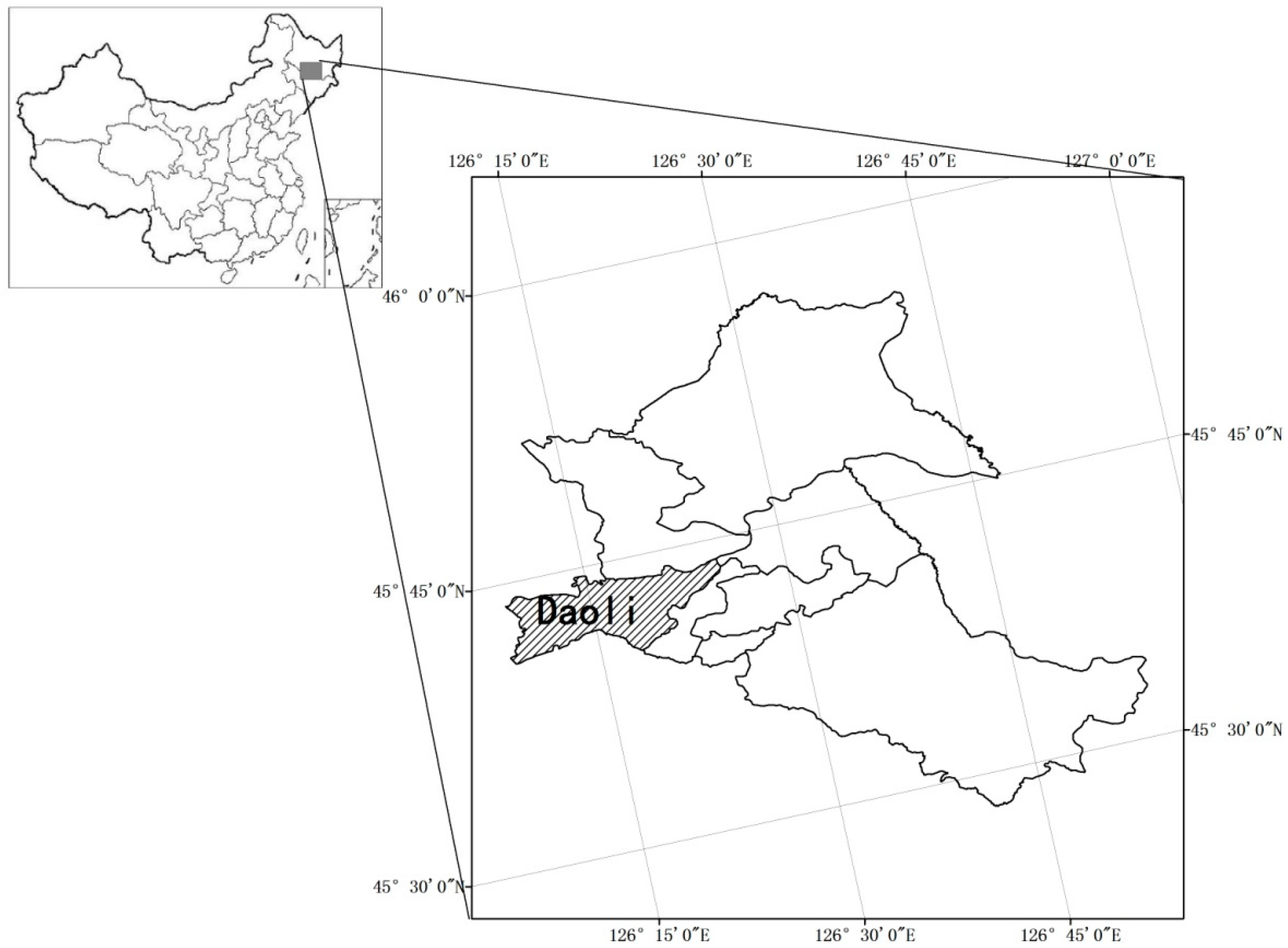
- Chen, P.; Zhang, J.; Yan, D. Numerical Simulation and Visualization of Urban Rainstorm Waterlogging Based on GIS—A Case Study of Daoli District in Haerbin City. J. Catastrophol. 2011, 26, 69–72. (In Chinese) [Google Scholar]
- Perla, P. The Art of Wargaming; Naval Institute Press: Annapolis, MD, USA, 2012. [Google Scholar]
- Xu, X.; Wang, S. Modern Battle Simulation; Science Press: Beijing, China, 2001. (In Chinese) [Google Scholar]
- Yang, K.; Yuan, W. Analysis of New Competitive Economics to Urban development’ Dynamics in Economic Globalization. Urban Res. 2000, 2, 19–22. (In Chinese) [Google Scholar]
- Chen, R.; Chen, Q. Analysis of causes for urban water logging in Nanning city. GX Water Resour. Hydropower Eng. 2009, 11, 26–27. (In Chinese) [Google Scholar]
- Zhang, W.; Li, S.; Shi, Z. Formation causes and coping strategies of urban rainstorm waterlogging in China. J. Nat. Disasters 2012, 21, 180–184. (In Chinese) [Google Scholar]
- Zhuang, J. The Causes of Waterlogging and the Measures of Harnessing for Jiangnan Zone of Quanzhou. Water Conserv. Sci. Technol. Econ. 2006, 12, 553–555. (In Chinese) [Google Scholar]
- Wang, J.; Xue, C.; Xie, Y.; Jin, L.; Xue, R. Causalative Analysis of Urban Waterlogging Induced by Severe Rainfall in Xi’an with Numerical Model. Meteorol. Sci. Technol. 2008, 36, 772–774. (In Chinese) [Google Scholar]
- Guo, X.; Ren, G.; Guo, Y. Influential factors for city waterlogging and the meteorological Service. J. Catastrophol. 2008, 23, 46–49. (In Chinese) [Google Scholar]
- Li, J.; Che, W. Rainwater problems and countermeasures for sustainable development in cities. Urban Environ. Urban Ecol. 2005, 18, 5–8. (In Chinese) [Google Scholar]
- Zoppou, C. Review of urban storm water models. Environ. Model. Softw. 2001, 16, 195–231. [Google Scholar] [CrossRef]
- Geng, H.; Wu, Z.; Ji, H.; Chen, H. GIS-Based Risk Zonation of Flood Disasters in Jiading District of Shanghai. J. Catastrophol. 2015, 30, 96–101. (In Chinese) [Google Scholar]
- Yin, Z.; Xu, S.; Yin, J.; Wang, J. Small-scale Based Scenario Modeling and Disaster Risk Assessment of Urban Rainstorm Waterlogging. Acta Geogr. Sin. 2010, 65, 553–562. (In Chinese) [Google Scholar]
- Yang, Q.; Jia, A. Research on Inundation Area of Flood Disaster and Evacuation Plan Based on ArcGIS. Water Resour. Power 2011, 29, 35–36. (In Chinese) [Google Scholar]
- Liu, Y. War Game and War Game Exercise; National Defense University Press: Beijing, China, 2013. (In Chinese) [Google Scholar]
- Perla, P.P.; McGrady, E.D. Why wargaming works. Naval War Coll. Rev. 2011, 64, 111. [Google Scholar]
- Blank, D. Military Wargaming: A commercial Battlefield. Jane’s Defence Weekly, 4 February 2004. [Google Scholar]
- Wang, G.; Liu, H.; Zhu, N. A Survey of War Games Technology. Ordnance Ind. Autom. 2012, 31, 39–45. (In Chinese) [Google Scholar]
- Xia, B.; Zhang, X.; Wang, H. Emergency Drills and Exercises Design; Contemporary China Publishing House: Beijing, China, 2011. (In Chinese) [Google Scholar]
- Peng, C.; Ju, R.; Yang, J.; Huang, K. Analysis of Technology of Modern Wargaming. J. Syst. Simul. 2009, 21, 97–100. (In Chinese) [Google Scholar]
- Ross, D. Designing a System on System Wargame; US Air Force Research Lab.: Wright-Patterson, OH, USA, 2006. [Google Scholar]
- Zhang, K.; Qiu, X.; Peng, C.; Cehn, B.; Huang, K. Design and Implementation of Distributed Simulation Experiment Management System. J. Syst. Simul. 2008, 20, 6627–6630. (In Chinese) [Google Scholar]
- Alberts, D.S. Understanding Information Age Warfare; CCRP Publications: Washington, DC, USA, 2001; pp. 22–24. [Google Scholar]
- Marsland, T.A. A Review of Game Tree Pruning. ICGA J. 1986, 9, 3–19. [Google Scholar]
- Theresa-Marie, R. Computer games’ influence on scientific and information visualization. Computer 2000, 33, 154–159. [Google Scholar]
- Chen, P.; Zhang, J.; Jiang, X.; Liu, X.; Bao, Y.; Sun, Y. Scenario simulation-based assessment of trip difficulty for urban residents under rainstorm waterlogging. Int. J. Environ. Res. Public Health 2012, 9, 2057–2074. [Google Scholar] [CrossRef] [PubMed]
- Chen, P.; Zhang, J.; Zhang, L.; Sun, Y. Evaluation of resident evacuations in urban rainstorm waterlogging disasters based on scenario simulation: Daoli district (Harbin, China) as an example. Int. J. Environ. Res. Public Health 2014, 11, 9964–9980. [Google Scholar] [CrossRef] [PubMed]
- Chen, P.; Zhang, J.; Sun, Y.; Liu, X. Emergency sheltering of urban residents in waterlogging disaster by war game exercise theory and method. Yangtze River 2016, 47, 8–11. (In Chinese) [Google Scholar]


| Department | Responsibility |
|---|---|
| Judge/Ruling Group | Setting emergency events, evaluation |
| Emergency Center | Plan initiation, monitoring, reporting, evacuation commanding |
| Bureau of Meteorology | Warning, weather monitoring, media |
| Armed Police | Search, rescue and organize resident, evacuation, repair, emergency transport |
| Public Security Bureau | Resident evacuation, traffic control, casualty statistics, disaster report |
| Water Conservancy Bureau | Water monitoring, reinforcement repair |
| Health Bureau | Wound treatment, epidemic prevention |
| Finance Bureau | Supply preparation, emergency fund raising |
| Construction Bureau | Supply preparation |
| Commerce Bureau | Supply preparation |
| Transportation Bureau | Traffic control, traffic redirection |
| Hydrology Bureau | Water monitoring, data collection, technical support |
| Power Supply Bureau | Power security |
| Civil Affairs Bureau | Disaster statistics, set up and select emergency shelters |
| Drainage Company | Road water drainage |
| Urban Management Bureau. | Road cleaning |
| Settlement Management Center | Emergency shelter management |
| Housing Security Bureau | Reinforcing repair |
| Propaganda Department | Media |
| Information Commission | Communication security |
| Rounds | P = 0.5a | P = 1a | P = 2a | P = 3a | P = 5a |
|---|---|---|---|---|---|
| 1 | 0.038 | 0.054 | 0.069 | 0.078 | 0.089 |
| 2 | 0.043 | 0.060 | 0.077 | 0.087 | 0.100 |
| 3 | 0.049 | 0.068 | 0.088 | 0.099 | 0.113 |
| 4 | 0.056 | 0.078 | 0.101 | 0.114 | 0.130 |
| 5 | 0.066 | 0.092 | 0.118 | 0.133 | 0.153 |
| 6 | 0.079 | 0.110 | 0.142 | 0.160 | 0.184 |
| 7 | 0.098 | 0.137 | 0.176 | 0.199 | 0.228 |
| 8 | 0.127 | 0.178 | 0.229 | 0.259 | 0.296 |
| 9 | 0.177 | 0.247 | 0.318 | 0.359 | 0.411 |
| 10 | 0.272 | 0.381 | 0.490 | 0.554 | 0.634 |
| 11 | 0.507 | 0.710 | 0.913 | 1.032 | 1.182 |
| 12 | 1.462 | 2.048 | 2.634 | 2.976 | 3.408 |
| 13 | 0.507 | 0.710 | 0.913 | 1.032 | 1.182 |
| 14 | 0.272 | 0.381 | 0.490 | 0.554 | 0.634 |
| 15 | 0.177 | 0.247 | 0.318 | 0.359 | 0.411 |
| 16 | 0.127 | 0.178 | 0.229 | 0.259 | 0.296 |
| 17 | 0.098 | 0.137 | 0.176 | 0.199 | 0.228 |
| 18 | 0.079 | 0.110 | 0.118 | 0.133 | 0.153 |
| Types | Flexible Grids |
|---|---|
| Hospital car | 30 |
| Transport cart | 24 |
| Emergency communications vehicles | 36 |
| Truck | 18 |
| Boat | 18 |
| Charge boat | 30 |
| Cars | 35 |
| Motorcycle | 30 |
| Command | Destination | Start | End | Expected | Sustaining | Score | |
|---|---|---|---|---|---|---|---|
| Meteorology Bureau | Issue warning | CPC commission/government | 1 | 1 | 1 | 1 | 1 |
| Warning | Residents | 2 | 4 | 3 | 4 | 0.75 | |
| CPC commission/government | Establish emergency command center | Hexagon grid | 1 | 1 | 1 | 1 | 1 |
| Emergency command center | Plan initiation | Emergency command center | 1 | 1 | 1 | 1 | 1 |
| Monitor | Hexagon grid | 2 | 99 | 4 | 99 | 0.7 | |
| Public security bureau | On-call | — | 2 | 6 | 2 | 5 | 1 |
| Armed police | On-call | — | 2 | 6 | 2 | 5 | 1 |
| Health bureau | Supply preparation | Health bureau | 2 | 6 | 2 | 5 | 1 |
| Finance bureau | Supply preparation | Finance bureau | 2 | 6 | 2 | 5 | 1 |
| Construction bureau | Supply preparation | Construction bureau | 2 | 6 | 2 | 5 | 1 |
| Commerce bureau | Supply preparation | Commerce bureau | 2 | 6 | 2 | 5 | 1 |
| Transportation bureau | Supply preparation | Transportation bureau | 2 | 6 | 2 | 5 | 1 |
| Information commission | Communication assurance | Information commission | 2 | 99 | 6 | 99 | 0.5 |
| Command | Destination | Start | End | Expected | Sustained | Score | |
|---|---|---|---|---|---|---|---|
| Emergency command center | Rescue command | Emergency command center | 7 | 7 | 7 | 2 | 1 |
| Police Department | Traffic control | Road | 8 | 12 | 7 | 5 | 0.88 |
| Resident evacuation | Subdivision, settlements | 7 | 10 | 7 | 4 | 1 | |
| Casualty count | Police department | 10 | 12 | 10 | 3 | 1 | |
| Status report | Emergency command center | 10 | 12 | 10 | 3 | 1 | |
| Armed police | Rescue | Resident | 7 | 12 | 7 | 5 | 1 |
| Casualty count | Armed police | 10 | 12 | 10 | 3 | 1 | |
| Status report | Emergency command center | 10 | 12 | 10 | 3 | 1 | |
| Hydrology bureau and water conservancy bureau | Storm water monitoring | Hexagon | 8 | 12 | 8 | 6 | 1 |
| Data collection | Hydrology bureau | 8 | 12 | 8 | 6 | 1 | |
| Health bureau | Wound treatment | Wounded residents | 8 | 12 | 8 | 6 | 1 |
| Emergency transport | Hexagon | 8 | 12 | 8 | 6 | 1 | |
| Casualty count | Health bureau | 8 | 12 | 8 | 6 | 1 | |
| Status report | Emergency command center | 8 | 12 | 8 | 6 | 1 | |
| Electricity Bureau | Power supply security | Electricity bureau | 7 | 12 | 7 | 6 | 1 |
| Meteorology bureau | Press release | Residents | 9 | 12 | 7 | 7 | 0.75 |
| Communication commission | Press release | Residents | 9 | 12 | 7 | 7 | 0.75 |
| Transportation bureau | Emergency transport | Hexagon net | 9 | 11 | 9 | 5 | 1 |
| Command | Target | Start | End | Expected | Sustained | Score | |
|---|---|---|---|---|---|---|---|
| Emergency command center | Evacuation command | Emergency command center | 13 | 16 | 13 | 5 | 1 |
| Technical support | Emergency command center | 13 | 16 | 13 | 5 | 1 | |
| Monitor | — | 14 | 16 | 14 | 6 | 1 | |
| Ruling group | Traffic control | Water monitor site | 13 | 13 | 13 | 1 | -- |
| Traffic control | Communication network | 13 | 13 | 13 | 1 | -- | |
| Traffic control | Electric facility | 13 | 13 | 13 | 1 | -- | |
| Meteorology bureau | Emergency transport | Mobile monitoring vehicle | 15 | 17 | 14 | 3 | 0.5 |
| Information commission | Emergency transport | Mobile monitoring vehicle | 14 | 17 | 14 | 4 | 1 |
| Armed police | Reinforcement | Damaged electric facility | 16 | 18 | 14 | 4 | 0.6 |
| Propaganda department | Press release | Residents | 14 | 18 | 14 | 5 | 1 |
| Command | Target | Start | End | Expected | Sustained | Score | |
|---|---|---|---|---|---|---|---|
| Emergency command center | Evacuation command | Emergency command center | 19 | 23 | 19 | 8 | 1 |
| Civil affairs bureau | Settlement site selection | Temporary accommodation | 20 | 23 | 20 | 3 | 1 |
| Report to placement center | Temporary accommodation | 21 | 23 | 21 | 3 | 1 | |
| Transportation departments | Emergency transportation | Hexagon | 20 | 23 | 20 | 3 | 1 |
| Emergency transportation | Hexagon | 22 | 23 | 21 | 3 | 0.86 | |
| Civil affairs bureau | Casualty count | Civil affairs bureau | 23 | 23 | 23 | 1 | 1 |
| Status report | Emergency command center | 23 | 23 | 23 | 1 | 1 | |
| Health bureau | Casualty report | Health bureau | 23 | 22 | 23 | 1 | 1 |
| Status report | Emergency command center | 24 | 22 | 23 | 1 | 0 | |
| Public Security Department | Casualty report | Public Security Department | 23 | 23 | 23 | 1 | 1 |
| Status report | Emergency command center | 23 | 23 | 23 | 1 | 1 | |
| Propaganda department | Press release | Residents | 20 | 240 | 21 | 6 | 0.8 |
| Command | Target | Start | End | Expected | Sustained | Score | |
|---|---|---|---|---|---|---|---|
| Emergency command center | Emergency command | Placement center | 25 | 30 | 25 | 5 | 1 |
| Storm water company | Water removal | Hexagon grid | 26 | 30 | 25 | 5 | 0.83 |
| City management bureau | Road cleaning | Hexagon grid | 25 | 30 | 25 | 5 | 1 |
| Health bureau | Epidemic prevention | Hexagon grid | 26 | 30 | 25 | 5 | 0.83 |
| Placement management center | Resident placement | Residents | 24 | 30 | 24 | 5 | 1 |
| Housing security administration | Reinforcement repair | Site | 27 | 30 | 27 | 4 | 1 |
| Propaganda bureau | Press release | Residents | 26 | 30 | 26 | 6 | 1 |
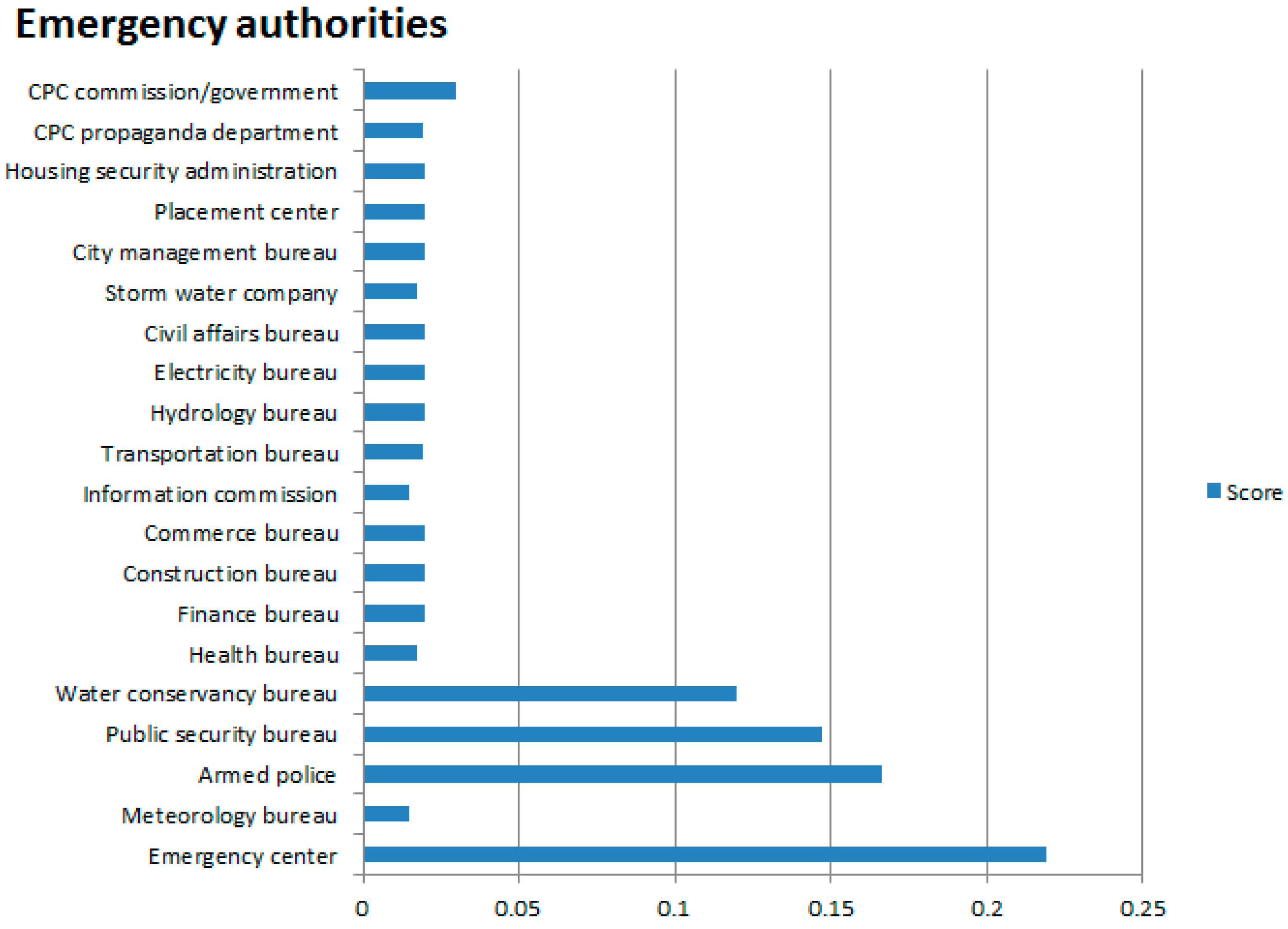
| Department | Mean Score | Weight | Department Score | Department | Mean Score | Weight | Department Score |
|---|---|---|---|---|---|---|---|
| Emergency center | 0.963 | 0.22 | 0.219 | Transportation bureau | 0.965 | 0.02 | 0.019 |
| Meteorology bureau | 0.750 | 0.02 | 0.015 | Hydrology bureau | 1.000 | 0.02 | 0.020 |
| Armed police | 0.920 | 0.18 | 0.166 | Electricity bureau | 1.000 | 0.02 | 0.020 |
| Public security bureau | 0.983 | 0.15 | 0.147 | Civil affairs bureau | 1.000 | 0.02 | 0.020 |
| Water conservancy bureau | 1.000 | 0.12 | 0.120 | Storm water company | 0.830 | 0.02 | 0.017 |
| Health bureau | 0.854 | 0.02 | 0.017 | City management bureau | 1.000 | 0.02 | 0.020 |
| Finance bureau | 1.000 | 0.02 | 0.020 | Placement center | 1.000 | 0.02 | 0.020 |
| Construction bureau | 1.000 | 0.02 | 0.020 | Housing security administration | 1.000 | 0.02 | 0.020 |
| Commerce bureau | 1.000 | 0.02 | 0.020 | CPC propaganda department | 0.933 | 0.02 | 0.019 |
| Information commission | 0.75 | 0.02 | 0.015 | CPC commission/government | 1.000 | 0.03 | 0.030 |
| Total | 75.90 | Total | 20.50 |
© 2016 by the authors; licensee MDPI, Basel, Switzerland. This article is an open access article distributed under the terms and conditions of the Creative Commons Attribution (CC-BY) license (http://creativecommons.org/licenses/by/4.0/).
Share and Cite
Chen, P.; Zhang, J.; Sun, Y.; Liu, X. Wargame Simulation Theory and Evaluation Method for Emergency Evacuation of Residents from Urban Waterlogging Disaster Area. Int. J. Environ. Res. Public Health 2016, 13, 1260. https://0-doi-org.brum.beds.ac.uk/10.3390/ijerph13121260
Chen P, Zhang J, Sun Y, Liu X. Wargame Simulation Theory and Evaluation Method for Emergency Evacuation of Residents from Urban Waterlogging Disaster Area. International Journal of Environmental Research and Public Health. 2016; 13(12):1260. https://0-doi-org.brum.beds.ac.uk/10.3390/ijerph13121260
Chicago/Turabian StyleChen, Peng, Jiquan Zhang, Yingyue Sun, and Xiaojing Liu. 2016. "Wargame Simulation Theory and Evaluation Method for Emergency Evacuation of Residents from Urban Waterlogging Disaster Area" International Journal of Environmental Research and Public Health 13, no. 12: 1260. https://0-doi-org.brum.beds.ac.uk/10.3390/ijerph13121260