Changes in Olive Urban Forests Infected by Xylella fastidiosa: Impact on Microclimate and Social Health

 ,
,  ,
,  , , ,
, , ,  and
and 
Abstract
:1. Introduction
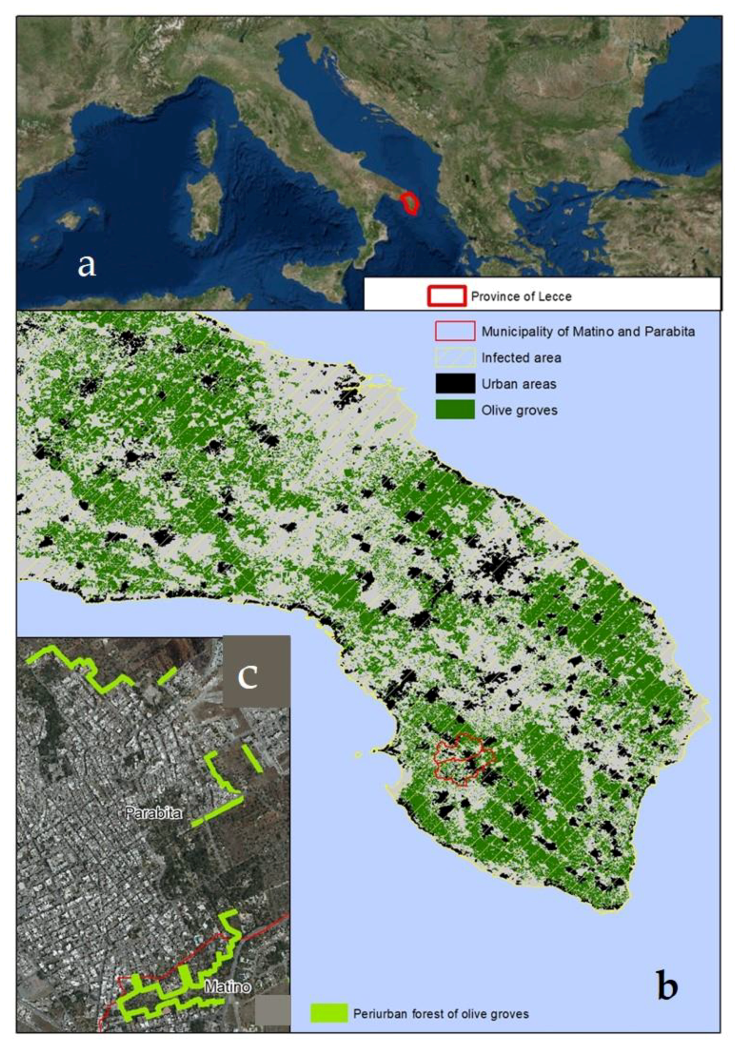
2. Study Area
3. Materials and Methods
3.1. Ecosystem Services Changes
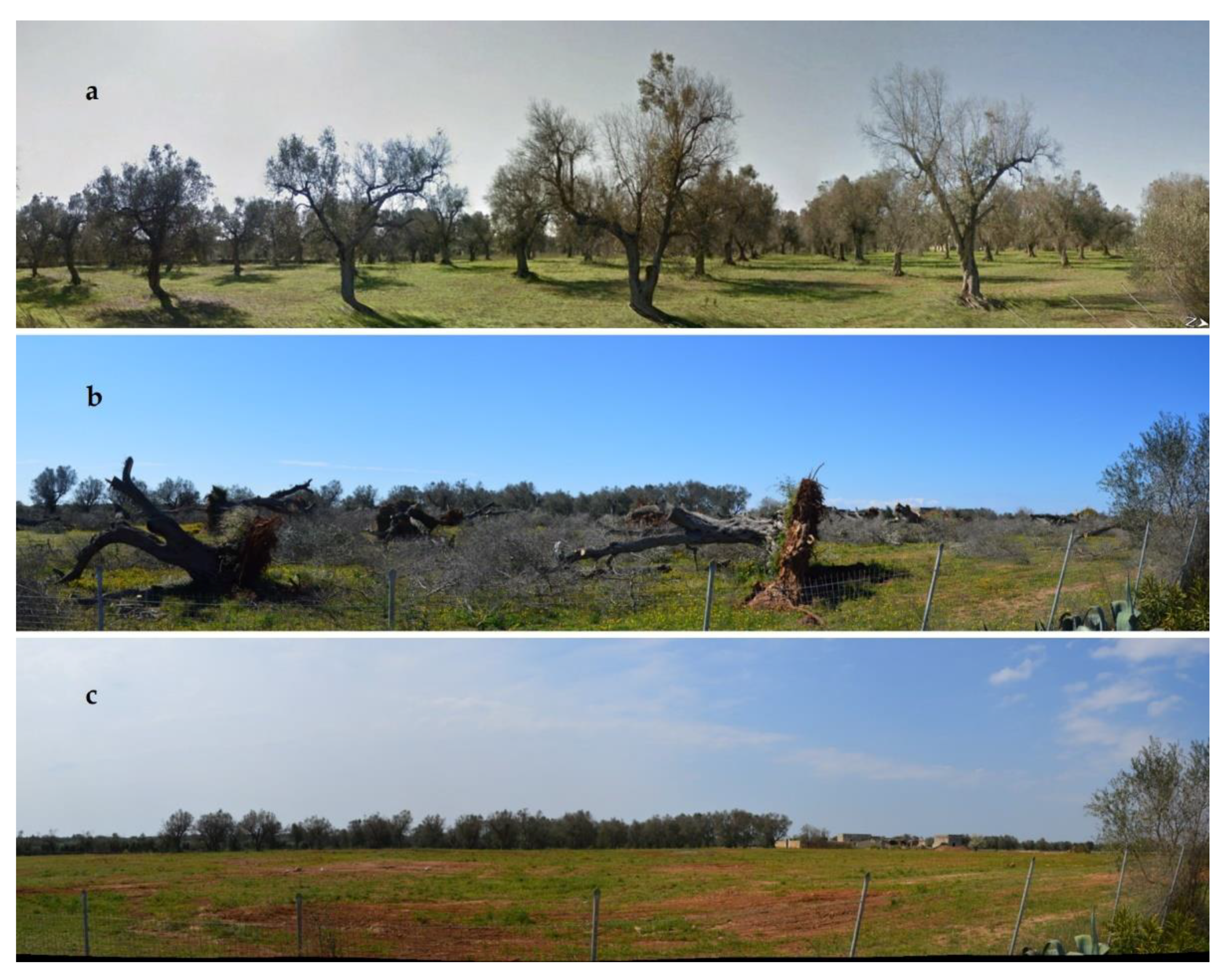
3.2. Changes in Olive Grove and Disease Severity Assessment
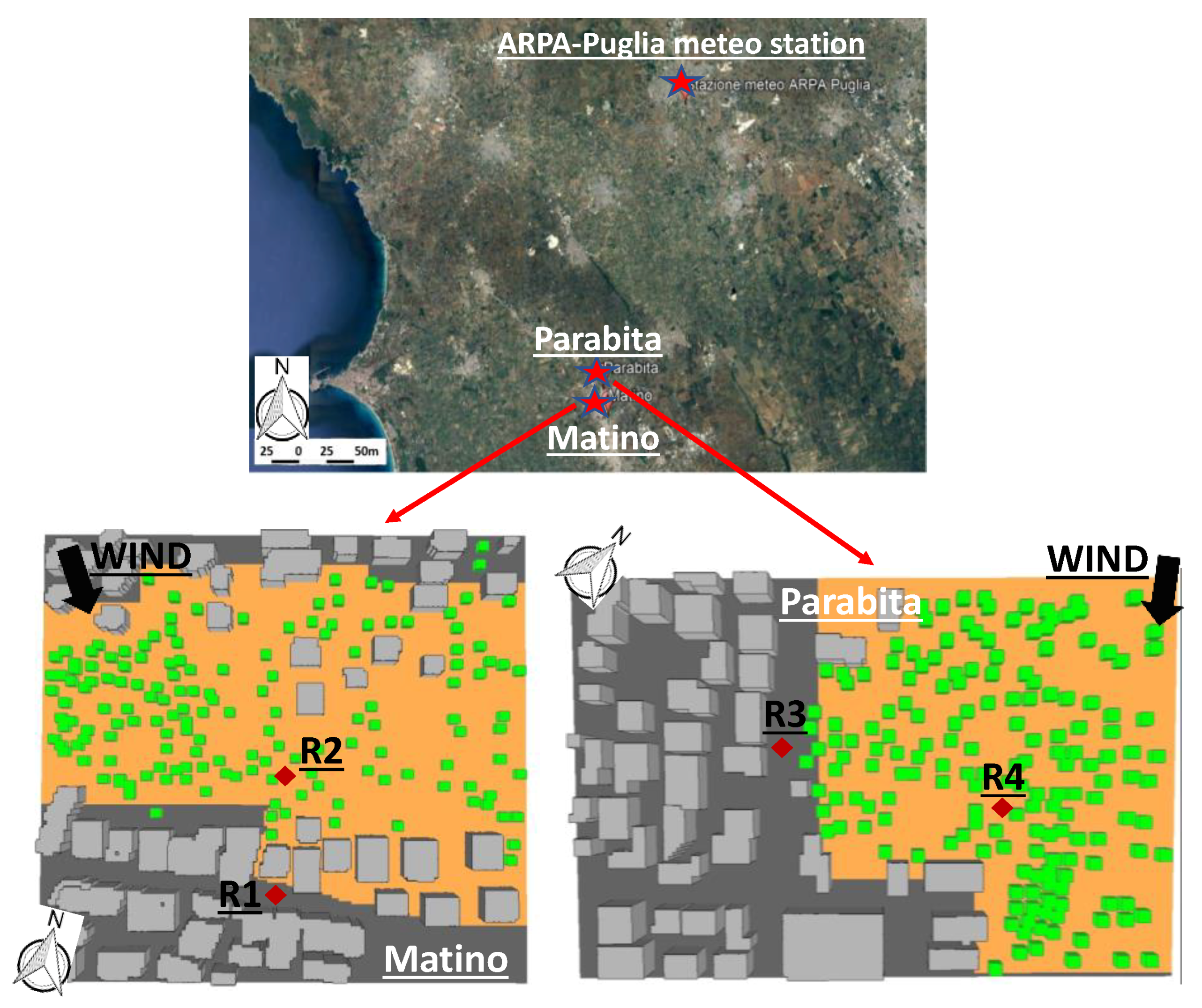
3.3. Impact of Olive Tree Loss on Microclimate in the Selected Neighborhoods
3.3.1. Numerical Simulations
3.3.2. Thermal Comfort Indices
4. Results
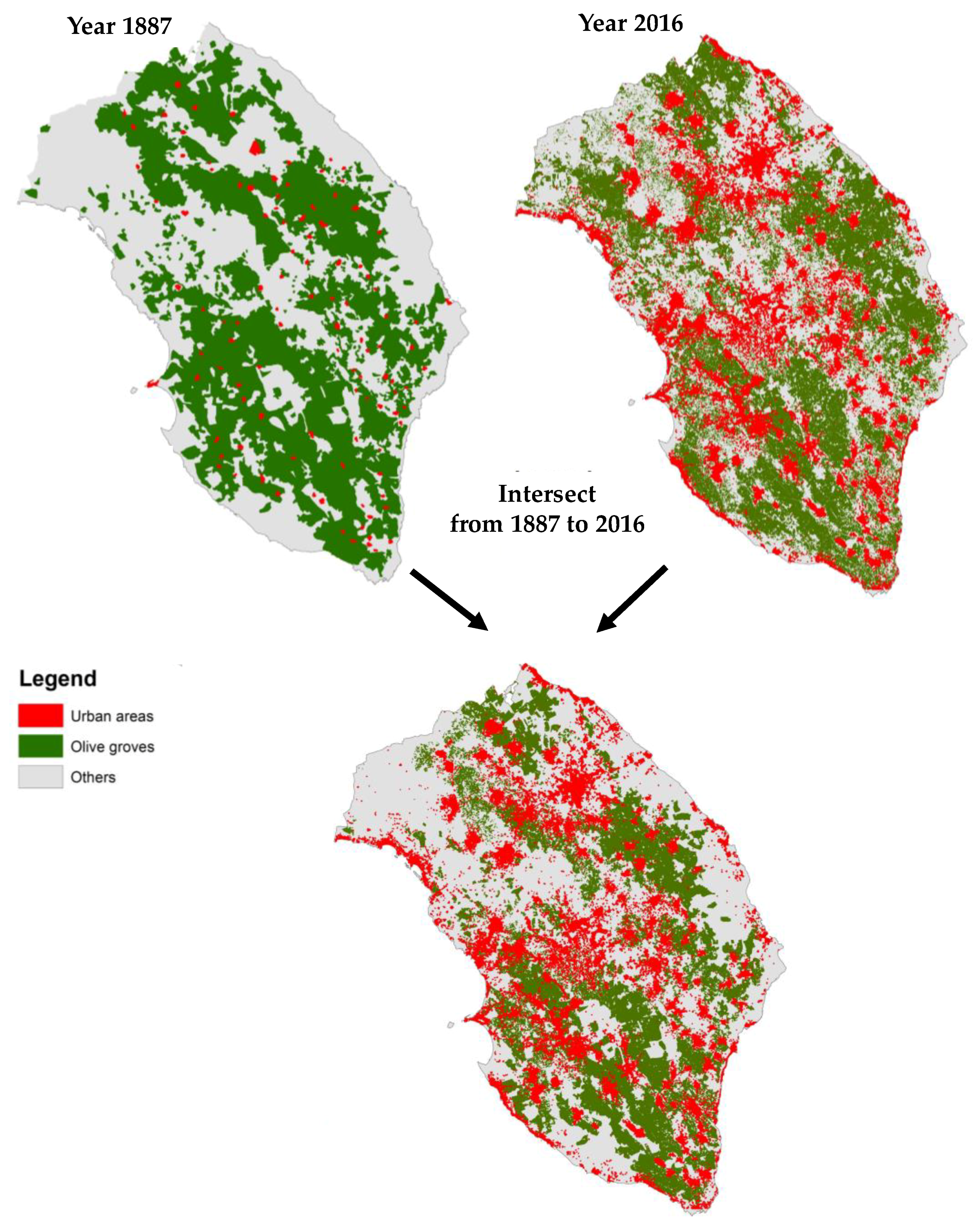
4.1. Analysis of Ecosystem Services Changes

| Functions | Ecosystem Processes and Components | Ecosystem Services | Variation from Old Olive Groves to Uncultivated Areas | Environmental M atrix Directed and Undirected Affected | Reversible | |
|---|---|---|---|---|---|---|
| Regulation functions (Maintenance of essential ecological processes and life support systems) | Gas regulation | Role of ecosystems in bio-geochemical cycles (e.g., CO2/O2 balance, ozone layer, etc.) | UVB-protection by O3 (preventing disease); Maintenance of (good) air quality; Influence on climate | ☹☹☹ | Air Biodiversity population | Yes |
| Climate regulation | Influence of land cover and biol. Mediated processes (e.g., DMS-production) on climate | Maintenance of a favorable climate (temp., precipitation, etc.) for human habitation, health, cultivation. | ☹☹ | Air Soil Water Biodiversity population | Yes | |
| Disturbance prevention | Influence of ecosystem structure on dampening env. disturbances | Storm protection (e.g., by coral reefs); Flood prevention (e.g., by wetlands and forests) | not evaluated | |||
| Water regulation | Role of land cover in regulating runoff and river discharge | Drainage and natural irrigation | = | Soil Water Biodiversity population | ||
| Water supply | Filtering, retention and storage of fresh water (e.g., in aquifers) | Provision of water for consumptive use (e.g., drinking, irrigation and industrial use) | = | Soil Water Biodiversity population | ||
| Soil retention | Role of vegetation root matrix and soil biota in soil retention | Maintenance of arable land; Prevention of damage from erosion/siltation. | ☹ | Soil Biodiversity population | Yes | |
| Soil formation | Weathering of rock, accumulation of organic matter | Maintenance of productivity on arable land; Maintenance of natural productive soils; | ☹ | Soil Biodiversity population | Yes | |
| Nutrient regulation | Role of biota in storage and recycling of nutrients (e.g., N, P and S) | Maintenance of healthy soils and productive ecosystems | ☹ | Soil Water Biodiversity population | Yes | |
| Waste treatment | Role of vegetation and biota in removal or breakdown of xenic nutrients and compounds | Pollution control/detoxification; Filtering of dust particles (air quality) Abatement of noise pollution | not evaluated | Soil Water Biodiversity population | ||
| Pollination | Role of biota in movement of floral gametes | Pollination of wild plant species; Pollination of crops. | = | Biodiversity population | ||
| Biological control | Population control through trophic-dynamic relations | Control of pests and diseases; Reduction of herbivory (crop damage). | not evaluated | Soil Biodiversity population | ||
| Habitat functions (Providing habitat (suitable living space) for wild plant and animal species) | Refugium function | Suitable living space for wild plants and animals | Maintenance of biological and genetic diversity (and, thus, the basis for most other functions) | ☹ | Biodiversity Population cultural landscape | Yes |
| Nursery function | Suitable reproduction-habitat | Maintenance of commercially harvested species | ☹ | Biodiversity Population cultural landscape | Yes | |
| Production functions (Provision of natural resources) | Food | Conversion of solar energy into edible plants and animals | Hunting, game, fruits, etc. Small-scale subsistence | ☹ | Biodiversity Population cultural landscape | Yes |
| Raw materials | Conversion of solar energy into biomass for human construction and other uses | Building and Manufacturing (e.g., lumber); Fuel and energy (e.g., fuel wood); | ☹ | Population cultural landscape | Yes | |
| Genetic resources | Genetic material and evolution in wild plants and animals | Improve crop resistance to pathogens and pests; Other applications (e.g., health care) | not evaluated | Yes | ||
| Medicinal resources | Variety in (bio)chemical substances in, and other medicinal uses of, natural biota | Drugs and pharmaceuticals; Chemical models and tools; Test and essay organisms | not evaluated | Yes | ||
| Information functions (Providing opportunities for cognitive development) | Aesthetic information | Attractive landscape features | Enjoyment of scenery (scenic roads, housing, etc.) | ☹☹☹ | Population cultural landscape | No |
| Re-creation | Variety in landscapes with (potential) re-creational uses | Travel to natural ecosystems for eco-tourism and (re-creational) nature study | ☹☹☹ | Population cultural landscape | No | |
| Cultural and artistic information | Variety in natural features with cultural and artistic value | Use of nature as motive in books, film, painting, folklore, national symbols, architect | ☹☹☹ | Population cultural landscape | No | |
| Spiritual and historic information | Variety in natural features with spiritual and historic value | Use of nature for religious or historic purposes (i.e., heritage value of natural ecosystems and features) | ☹☹☹ | Population cultural landscape | No | |
| Science and education | Variety in nature with scientific and educational value | Use of natural systems for school excursions, etc. Use of nature for scientific research | ☹☹☹ | Population cultural landscape | No | |
| Carrier functions (Providing a suitable substrate or medium for human activities and infrastructure) | Habitation | Depending on the specific land use type, different requirements are placed on environmental conditions (e.g., soil stability and fertility, air and water quality, topography, climate, geology, etc. | Living space (ranging from small settlements to urban areas) | ☹☹☹ | Population cultural landscape | No |
| Tourism-facilities | Tourism-activities (outdoor sports, beach-tourism, etc.) | ☹☹☹ | Population cultural landscape | No | ||
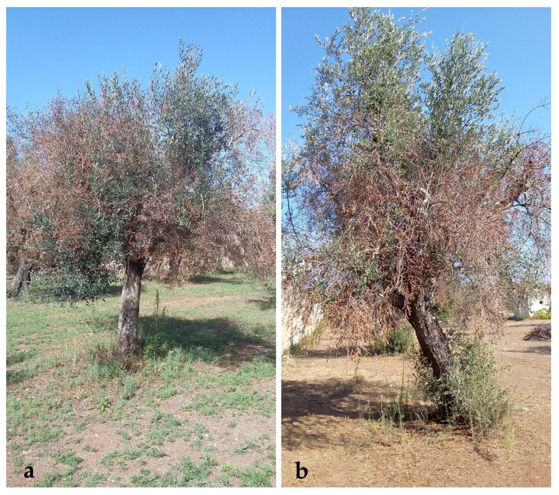
4.2. Analysis of Changes in Olive Grove and Disease Severity Assessment
4.3. Analysis of the Impact of Olive Tree Loss on Microclimate in the Selected Neighborhoods
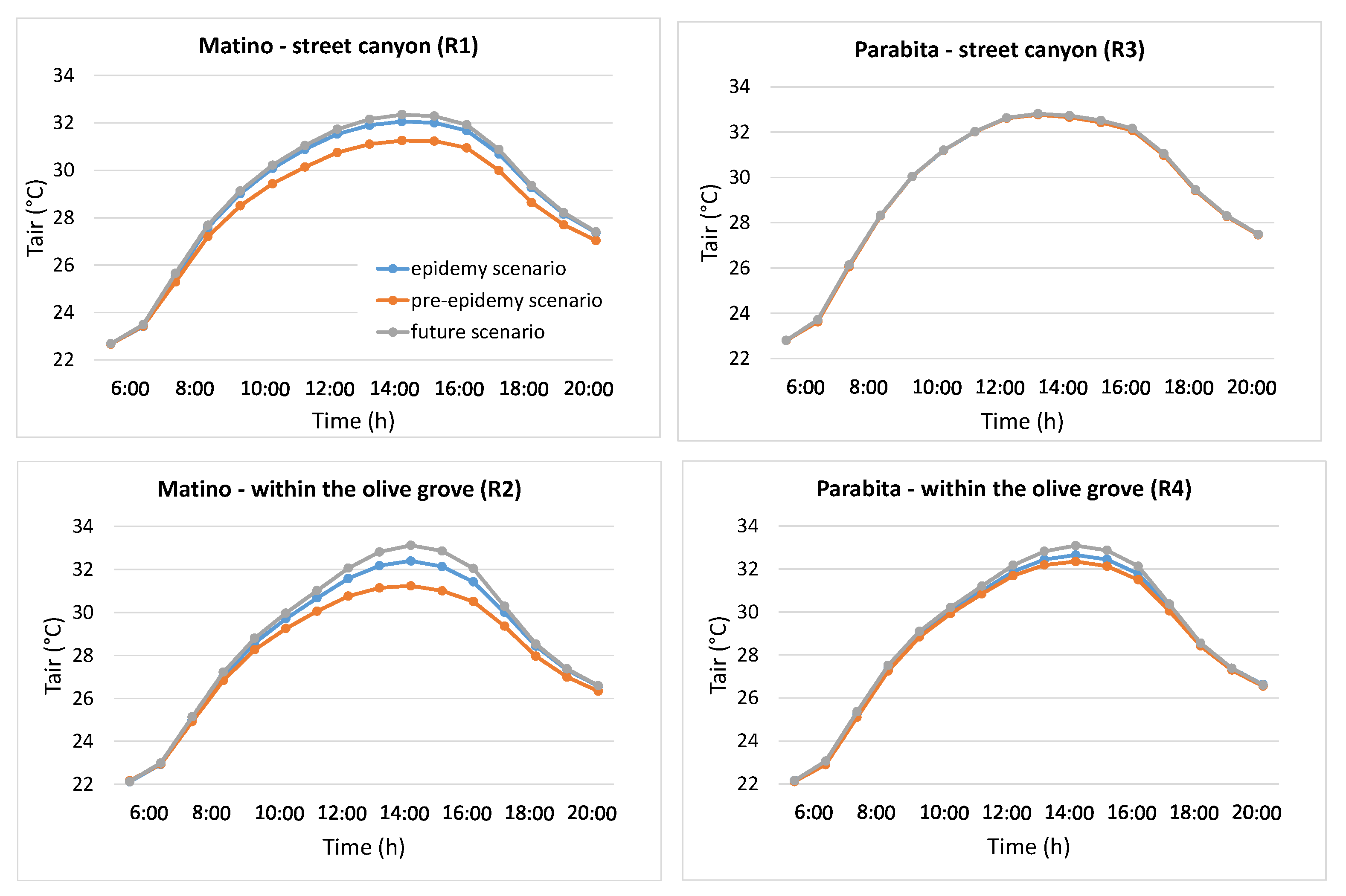
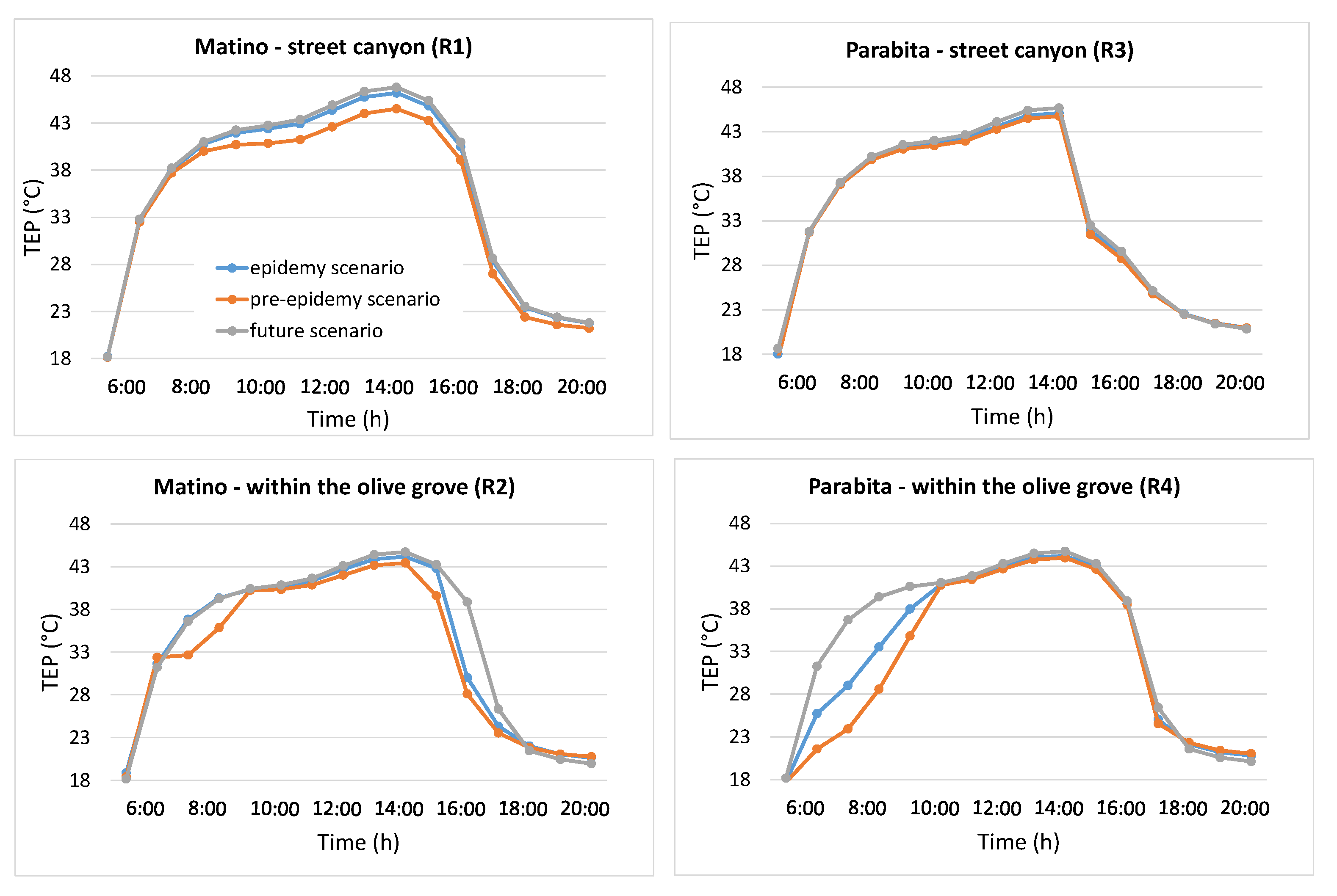
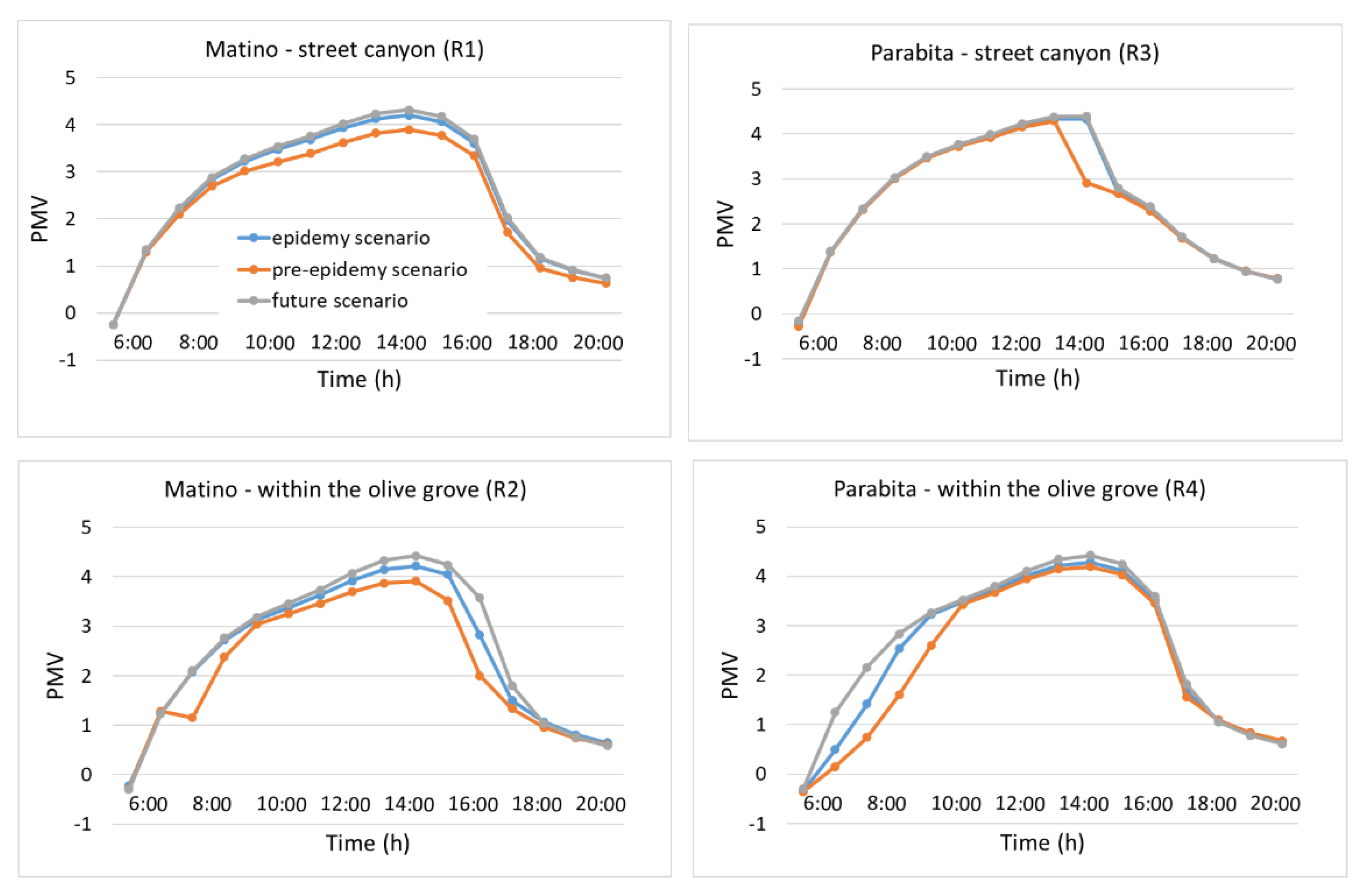
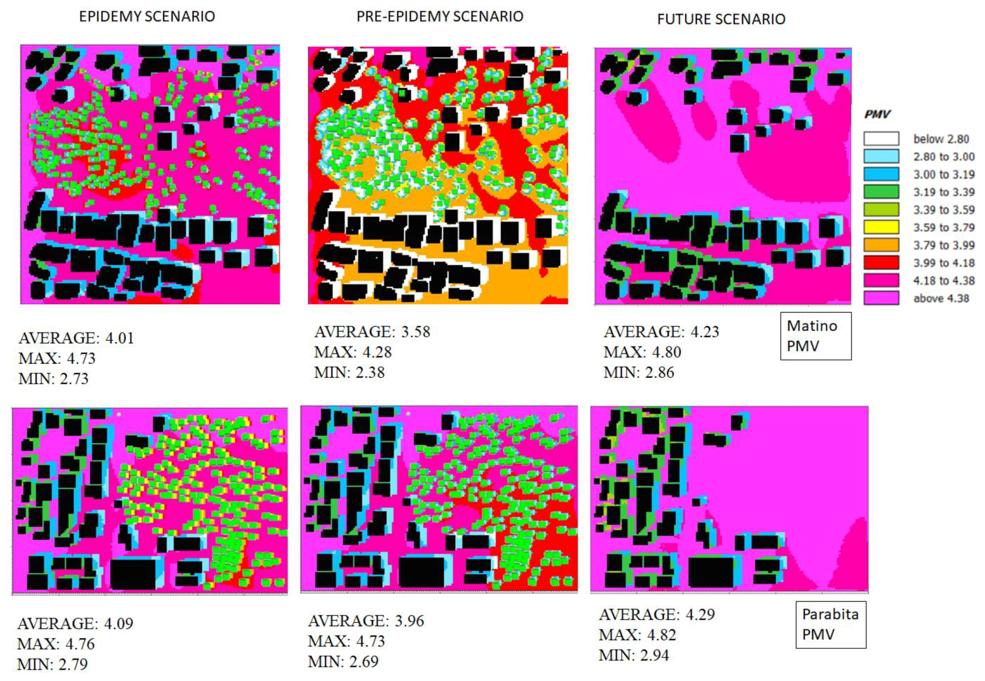
4.3.1. Temporal Profiles of Air Temperature, TEP and PMV
4.3.2. Spatial Distribution of PMV
5. Discussion
6. Conclusions
Author Contributions
Funding
Acknowledgments
Conflicts of Interest
References
- Snowdon, P.; Binner, A.; Smith, G.; Agarwala, M.; Day, B.; Bateman, I.; Harwood, A. Valuing the Social and Environmental Contribution of Woodlands and Trees in England, Scotland and Wales; Research Note; Forestry Commission: Edinburgh, UK, 2017.
- Berman, M.G.; Jonides, J.; Kaplan, S. The cognitive benefits of interacting with nature. Psychol. Sci. 2008, 19, 1207–1212. [Google Scholar] [CrossRef] [PubMed]
- Berman, M.G.; Kross, E.; Krpan, K.M.; Askren, M.K.; Burson, A.; Deldin, P.J.; Kaplan, S.; Sherdell, L.; Gotlib, I.H.; Jonides, J. Interacting with nature improves cognition and affect for individuals with depression. J. Affect. Disord. 2012, 140, 300–305. [Google Scholar] [CrossRef] [PubMed] [Green Version]
- Grahn, P.; Stigsdotter, U.A. Landscape planning and stress. Urban For. Urban Green. 2003, 2, 1–18. [Google Scholar] [CrossRef] [Green Version]
- White, M.P.; Alcock, I.; Wheeler, B.W.; Depledge, M.H. Would you be happier living in a greener urban area? A fixed-effects analysis of panel data. Psychol. Sci. 2013, 24, 920–928. [Google Scholar] [CrossRef] [PubMed]
- Bratman, G.N.; Hamilton, J.P.; Hahn, K.S.; Daily, G.C.; Gross, J.J. Nature experience reduces rumination and subgenual prefrontal cortex activation. Proc. Natl. Acad. Sci. USA 2015, 112, 8567–8572. [Google Scholar] [CrossRef] [PubMed] [Green Version]
- Mayer, F.S.; Frantz, C.M.; Bruehlman-Senecal, E.; Dolliver, K. Why is nature beneficial: The role of connectedness to nature. Environ. Behav. 2009, 41, 607–643. [Google Scholar] [CrossRef]
- Donovan, G.H.; Butry, D.T.; Michael, Y.L.; Prestemon, J.P.; Liebhold, A.M.; Gatziolis, D.; Mao, M.Y. The relationship between trees and human health: Evidence from the spread of the emerald ash borer. Am. J. Prev. Med. 2013, 44, 139–145. [Google Scholar] [CrossRef] [PubMed]
- James, P.; Hart, J.E.; Banay, R.F.; Laden, F. Exposure to greenness and mortality in a nationwide prospective cohort study of women. EHP Toxicogenomics 2016, 124, 1344–1352. [Google Scholar] [CrossRef] [PubMed]
- Ellaway, A.; Macintyre, S.; Bonnefoy, X. Graffiti, greenery, and obesity in adults: Secondary analysis of European cross sectional survey. BMJ 2005, 331, 611–612. [Google Scholar] [CrossRef] [PubMed]
- Salbitano, F.; Borelli, S.; Conigliaro, M.; Chen, Y. Guidelines on Urban and Peri-Urban Forestry; FAO Forestry Paper No.178; Food and Agriculture Organization of the United Nations: Rome, Italy, 2016. [Google Scholar]
- Livesley, S.J.; McPherson, E.G.; Calfapietra, C. The urban forest and ecosystem services: Impacts on urban water, heat, and pollution cycles at the tree, street, and city scale. J. Environ. Qual. 2016, 45, 119–124. [Google Scholar] [CrossRef] [PubMed]
- Salmond, J.A.; Tadaki, M.; Vardoulakis, S.; Arbuthnott, K.; Coutts, A.; Demuzere, M.; Dirks, K.N.; Heaviside, C.; Lim, S.; Macintyre, H.; et al. Health and climate related ecosystem services provided by street trees in the urban environment. Environ. Health 2016, 15, 36. [Google Scholar] [CrossRef] [PubMed]
- Santamouris, M.; Ban-Weiss, G.; Osmond, P.; Paolini, R.; Synnefa, A.; Cartalis, C.; Muscio, A.; Zinzi, M.; Morakinyo, T.E.; Ng, E.; et al. Progress in urban greenery mitigation science–assessment methodologies advanced technologies and impact on cities. J. Civ. Eng. Manag. 2018, 24, 638–671. [Google Scholar] [CrossRef]
- Pechanec, V.; Machar, I.; Pohanka, T.; Opršal, Z.; Petrovič, F.; Švajda, J.; Šálek, L.; Chobot, L.; Filippovová, J.; Cudlín, P.; et al. Effectiveness of Natura 2000 system for habitat types protection: A case study from the Czech Republic. Nat. Conserv. 2018, 24, 21–41. [Google Scholar] [CrossRef]
- Lester, L. Big tree, small news: Media access, symbolic power and strategic intervention. Journalism 2010, 11, 589–606. [Google Scholar] [CrossRef]
- Blicharska, M.; Mikusinski, G. Incorporating social and cultural significance of large old trees in conservation policy. Conserv. Biol. 2014, 28, 1558–1567. [Google Scholar] [CrossRef]
- Oprsal, Z.; Kladivo, P.; Machar, I. The role of selected biophysical factors in long-term land-use change of cultural landscape. Appl. Ecol. Environ. Res. 2016, 14, 23–40. [Google Scholar] [CrossRef]
- Bello, C.; Galetti, M.; Pizo, M.A.; Magnaso, L.F.S.; Rocha, M.F.; Lima, R.A.F.; Peres, C.A.; Ovaskainen, O.; Jordano, P. Defaunation affects carbon storage in tropical forests. Sci. Adv. 2015, 1, e1501105. [Google Scholar] [CrossRef] [Green Version]
- Lindenmayer, D.B.; Laurance, W.F.; Franklin, J.F. Global decline in large old trees. Science 2012, 338, 1305–1306. [Google Scholar] [CrossRef]
- Lindenmayer, D.B.; Laurance, W.F. The ecology, distribution, conservation and management of large old trees. Biol. Rev. Camb. Philos. Soc. 2017, 92, 1434–1458. [Google Scholar] [CrossRef]
- Daszak, P.; Cunningham, A.A.; Hyatt, A.D. Emerging infectious diseases of wildlife—Threats to biodiversity and human health. Science 2000, 287, 443–449. [Google Scholar] [CrossRef]
- Van Kleunen, M.; Dawson, W.; Essl, F.; Pergl, J.; Winter, M.; Weber, E.; Kreft, H.; Weigelt, P.; Kartesz, J.; Nishino, M.; et al. Global exchange and accumulation of non-native plants. Nature 2015, 525, 100–103. [Google Scholar] [CrossRef] [PubMed] [Green Version]
- Waipara, N.W.; Hill, S.; Hill, L.M.W.; Hough, E.G.; Horner, I.J. Surveillance methods to determine tree health, distribution of Kauri Dieback disease and associated pathogens. N. Z. Plant Prot. 2013, 66, 235–241. [Google Scholar]
- Giampetruzzi, A.; Morelli, M.; Saponari, M.; Loconsole, G.; Chiumenti, M.; Boscia, D.; Savino, V.N.; Martelli, G.P.; Saldarelli, P. Transcriptome profiling of two olive cultivars in response to infection by the CoDiRO strain of Xylella fastidiosa subsp. pauca. BMC Genomics 2016, 1, 475. [Google Scholar] [CrossRef] [PubMed]
- Saponari, M.; Boscia, D.; Nigro, F.; Martelli, G.P. Identification of DNA sequences related to Xylella fastidiosa in oleander, almond and olive trees exhibiting leaf scorch symptoms in Apulia (Southern Italy). J. Plant Pathol. 2013, 95, 668. [Google Scholar]
- Luvisi, A.; Nicolì, F.; De Bellis, L. Sustainable management of plant quarantine pests: The case of olive quick decline syndrome. Sustainability 2017, 9, 659. [Google Scholar] [CrossRef]
- Sabella, E.; Luvisi, A.; Aprile, A.; Negro, C.; Vergine, M.; Nicolì, F.; Miceli, A.; De Bellis, L. Xylella fastidiosa induces differential expression of lignification related-genes and lignin accumulation in tolerant olive trees cv. Leccino. J. Plant Physiol. 2018, 220, 60–68. [Google Scholar] [CrossRef] [PubMed]
- Loconsole, G.; Saponari, M.; Boscia, D.; D’Attoma, G.; Morelli, M.; Martelli, G.; Almeida, R.P.P. Intercepted isolates of Xylella fastidiosa in Europe reveal novel genetic diversity. Eur. J. Plant Pathol. 2016, 146, 85–94. [Google Scholar] [CrossRef]
- Chatterjee, S.; Almeida, R.P.; Lindow, S. Living in two worlds: The plant and insect lifestyles of Xylella fastidiosa. Annu. Rev. Phytopathol. 2008, 46, 243–271. [Google Scholar] [CrossRef] [PubMed]
- Lindow, S. Money Matters: Fueling Rapid Recent Insight Into Xylella fastidiosa—An Important and Expanding Global Pathogen. Phytopathology 2019, 109, 210–212. [Google Scholar] [CrossRef]
- Luvisi, A.; Aprile, A.; Sabella, E.; Vergine, M.; Nicolì, F.; Nutricati, E.; Miceli, A.; Negro, C.; De Bellis, L. Xylella fastidiosa subsp. pauca (CoDiRO strain) infection in four olive (Olea europaea L.) cultivars: Profile of phenolic compounds in leaves and progression of leaf scorch symptoms. Phytopathol. Mediterr. 2017, 56, 259–273. [Google Scholar] [CrossRef]
- Colella, C.; Carradore, R.; Cerro, A. Problem Setting and Problem Solving in the Case of Olive Quick Decline Syndrome in Apulia, Italy: A Sociological Approach. Phytopathology 2019, 109, 187–199. [Google Scholar] [CrossRef] [PubMed] [Green Version]
- Saponari, M.; Boscia, D.; Altamura, G.; Loconsole, G.; Zicca, S.; D’Attoma, G.; Morelli, M.; Palmisano, F.; Saponari, A.; Tavano, D.; et al. Isolation and pathogenicity of Xylella fastidiosa associated to the olive quick decline syndrome in southern Italy. Sci. Rep. 2017, 7, 17723. [Google Scholar] [CrossRef] [PubMed]
- Maggiore, G.; Semeraro, T.; Aretano, R.; De Bellis, L.; Luvisi, A. GIS Analysis of Land-Use Change in Threatened Landscapes by Xylella fastidiosa. Sustainability 2019, 11, 253. [Google Scholar] [CrossRef]
- Semeraro, T.; Pomes, A.; Del Giudice, C.; Negro, D.; Aretano, R. Planning ground based utility scale solar energy as green infrastructure to enhance ecosystem services. Energy Policy 2018, 117, 218–227. [Google Scholar] [CrossRef]
- ISTAT. Geodemo. Maps, Population, Demography of ISTAT—Italian Institute of Statistics. 2018. Available online: http://demo.istat.it/pop2018/index.html (accessed on 20 May 2019).
- Tsoka, S.; Tsikaloudaki, A.; Theodosiou, T. Analyzing the ENVI-met microclimate model’s performance and assessing cool materials and urban vegetation applications—A review. Sustain. Cities Soc. 2018, 43, 55–76. [Google Scholar] [CrossRef]
- ENVI-Met. Decoding Urban Nature—Microclimate Simulations, 2018. Available online: http://www.envi-met.info/doku.php?id=kb:review (accessed on 20 May 2019).
- Rui, L.; Buccolieri, R.; Gao, Z.; Ding, W.; Shen, J. The Impact of Green Space Layouts on Microclimate and Air Quality in Residential Districts of Nanjing, China. Forests 2018, 9, 224. [Google Scholar] [CrossRef]
- Monteiro, L.M.; Alucci, M.P. Proposal of an outdoor thermal comfort index: Empirical verification in the subtropical climate. In Proceedings of the 27th International Conference on Passive and Low Energy Architecture (PLEA 2011), Louvain-la-Neuve, Belgium, 13–15 July 2011; pp. 433–438. [Google Scholar]
- Almeida, R.P.P. Can Apulia’s olive trees be saved? Science 2016, 353, 346–348. [Google Scholar] [CrossRef]
- Costanza, R.; d’Arge, R.; de Groot, R.S.; Farber, S.; Grasso, M.; Hannon, B.; Limburg, K.; Naeem, S.; O’Neill, R.V.; Paruelo, J.; et al. The value of the world’s ecosystem services and natural capital. Nature 1997, 387, 253–260. [Google Scholar] [CrossRef]
- De Groot, R.S. Functions of Nature: Evaluation of Nature in Environmental Planning, Management and Decision-Making; Wolters Noordhoff BV: Groningen, The Netherlands, 1992. [Google Scholar]
- De Groot, R.S.; Wilson, M.; Boumans, R. A typology for the description, classification and valuation of Ecosystem Functions. Goods Serv. Econ. 2002, 41, 393–408. [Google Scholar] [CrossRef]
- De Groot, R.S. “Function-analysis and valuation as a tool to assess land use conflicts in planning for sustainable, multi-functional landscapes”, Landscape and Urban Planning. In Ecosystems and Human Well-Being: Synthesis; Millenium Ecosystem Assessment; Island Press: Washington, DC, USA, 2006; Volume 75, pp. 175–186. [Google Scholar]
- Wallace, K.J. Classification of ecosystem services: Problems and solutions. Biol. Conserv. 2007, 139, 235–246. [Google Scholar] [CrossRef] [Green Version]
- Burkhard, B.; Kroll, F.; Müller, F.; Windhorst, W. Landscapes‘ Capacities to Provide Ecosystem Services—A Concept for Land-Cover Based Assessments. Landsc. Online 2009, 15, 1–22. [Google Scholar] [CrossRef]
- Burkhard, B.; Kroll, F.; Nedkov, S.; Müller, F. Mapping ecosystem service supply, demand and budgets. Ecol. Indic. 2012, 21, 17–29. [Google Scholar] [CrossRef]
- Benayas, J.M.R.; Bullock, J.M. Restoration of Biodiversity and Ecosystem Services on Agricultural Land. Ecosystems 2012, 15, 883–899. [Google Scholar] [CrossRef]
- Scolozzi, R.; Moroni, E.; Santolini, R. Delphi-based change assessment in ecosystem service values to support strategic spatial planning in Italian landscapes. Ecol. Indic. 2012, 21, 134–144. [Google Scholar] [CrossRef]
- Burkhard, B.; Kandziora, M.; Hou, Y.; Müller, F. Ecosystem Service Potentials, Flows and Demands– Concepts for Spatial Localisation, Indication and Quantification. Landsc. Online 2014, 34, 1–32. [Google Scholar] [CrossRef]
- Koschke, L.; Fürst, C.; Frank, S.; Makeschin, F. A multi-criteria approach for an integrated land-cover-based assessment of ecosystem services provision to support landscape planning. Ecol. Indic. 2012, 21, 54–66. [Google Scholar] [CrossRef]
- Vihervaara, P.; Kumpula, T.; Tanskanen, A.; Burkhard, B. Ecosystem services—A tool for sustainable management of human–environment systems. Case study Finnish Forest Lapland. Ecol. Complex. 2010, 7, 410–420. [Google Scholar] [CrossRef]
- Clerici, N.; Paracchini, M.L.; Maes, J. Land-cover change dynamics and insights into ecosystem services in European stream riparian zones. Ecohydrol. Hydrobiol. 2014, 14, 107–120. [Google Scholar] [CrossRef]
- Gissi, E.; Burkhard, B.; Verburg, P.H. Ecosystem services: Building informed policies to orient landscape dynamics. Int. J. Biodivers. Sci. Ecosyst. Serv. Manag. 2015, 11, 185–189. [Google Scholar] [CrossRef]
- European Commission. Mapping and Assessment of Ecosystems and their Services. Joint Research Centre Institute for Environment and Sustainability. 2015. Available online: http://publications.jrc.ec.europa.eu/repository/bitstream/JRC94889/lbna27143enn.pdf (accessed on 20 May 2019).
- Aretano, R.; Petrosillo, I.; Zaccarelli, N.; Semeraro, T.; Zurlini, G. People perception of landscape change effects on ecosystem services in small Mediterranean islands: A combination of subjective and objective assessments. Landsc. Urban Plan. 2013, 112, 63–73. [Google Scholar] [CrossRef]
- Aretano, R.; Parlagreco, L.; Semeraro, T.; Zurlini, G.; Petrosillo, I. Coastal dynamics vs. beach users attitudes and perceptions to enhance environmental conservation and management effectiveness. Mar. Pollut. Bull. 2017, 123, 142–155. [Google Scholar] [CrossRef] [PubMed]
- Moreno, G.; Aviron, S.; Berg, S.; Crous-Duran, J.; Franca, A.; Garcíade Jalón, S.; Hartel, T.; Mirck, J.; Pantera, A.; Palma, J.H.N.; et al. Agroforestry systems of high nature and cultural value in Europe: Provision of commercial goods and other ecosystem services. Agroforest Syst. 2018, 92, 877–891. [Google Scholar] [CrossRef]
- Semeraro, T.; Mastroleo, G.; Aretano, R.; Facchinetti, G.; Zurlini, G.; Petrosillo, I. GIS Fuzzy Expert System for the assessment of ecosystems vulnerability to fire in managing Mediterranean natural protected areas. J. Environ. Manag. 2016, 168, 94–103. [Google Scholar] [CrossRef] [PubMed]
- IUCN—International Union for Conservation of Nature and Natural Resources. The IUCN Red List of Threatened Species. 2014. Version 2014.3. Available online: http://www.iucnredlist.org (accessed on 20 May 2019).
- Zurlini, G.; Petrosillo, I.; Jones, K.B.; Li, B.L.; Riitters, K.H.; Medagli, P.; Marchiori, S.; Zaccarelli, N. Towards the planning and design of disturbance patterns across scales to counter biological invasions. J. Environ. Manag. 2013, 128, 192–203. [Google Scholar] [CrossRef] [PubMed]
- Andrews, P.L. Behave Plus Fire Modeling System, Version 5.0: Variables; General Technical Report RMRS-GTR-213WWW Revised; Department of Agriculture, Forest Service, Rocky Mountain Research Station: Fort Collins, CO, USA, 2009. Available online: http://www.fs.fed.us/rm/pubs/rmrs_gtr213.pdf (accessed on 20 May 2019).
- Walker, B.; Holling, C.; Carpenter, S.; Kinzig, A. Resilience, adaptability and transformability in social-ecological systems. Ecol. Soc. 2004, 9, 5. [Google Scholar] [CrossRef]
- Cerroni, A.; Simonella, Z. Sociologia della Scienza. Capire la Scienza per Capire la Società Contemporanea; Carocci: Rome, Italy, 2014. [Google Scholar]


© 2019 by the authors. Licensee MDPI, Basel, Switzerland. This article is an open access article distributed under the terms and conditions of the Creative Commons Attribution (CC BY) license (http://creativecommons.org/licenses/by/4.0/).
Share and Cite
Semeraro, T.; Gatto, E.; Buccolieri, R.; Vergine, M.; Gao, Z.; De Bellis, L.; Luvisi, A. Changes in Olive Urban Forests Infected by Xylella fastidiosa: Impact on Microclimate and Social Health. Int. J. Environ. Res. Public Health 2019, 16, 2642. https://0-doi-org.brum.beds.ac.uk/10.3390/ijerph16152642
Semeraro T, Gatto E, Buccolieri R, Vergine M, Gao Z, De Bellis L, Luvisi A. Changes in Olive Urban Forests Infected by Xylella fastidiosa: Impact on Microclimate and Social Health. International Journal of Environmental Research and Public Health. 2019; 16(15):2642. https://0-doi-org.brum.beds.ac.uk/10.3390/ijerph16152642
Chicago/Turabian StyleSemeraro, Teodoro, Elisa Gatto, Riccardo Buccolieri, Marzia Vergine, Zhi Gao, Luigi De Bellis, and Andrea Luvisi. 2019. "Changes in Olive Urban Forests Infected by Xylella fastidiosa: Impact on Microclimate and Social Health" International Journal of Environmental Research and Public Health 16, no. 15: 2642. https://0-doi-org.brum.beds.ac.uk/10.3390/ijerph16152642