
A Systematic Study Site Selection Protocol to Determine Environmental Flows in the Headwater Catchments of the Vhembe Biosphere Reserve


Abstract
:1. Introduction
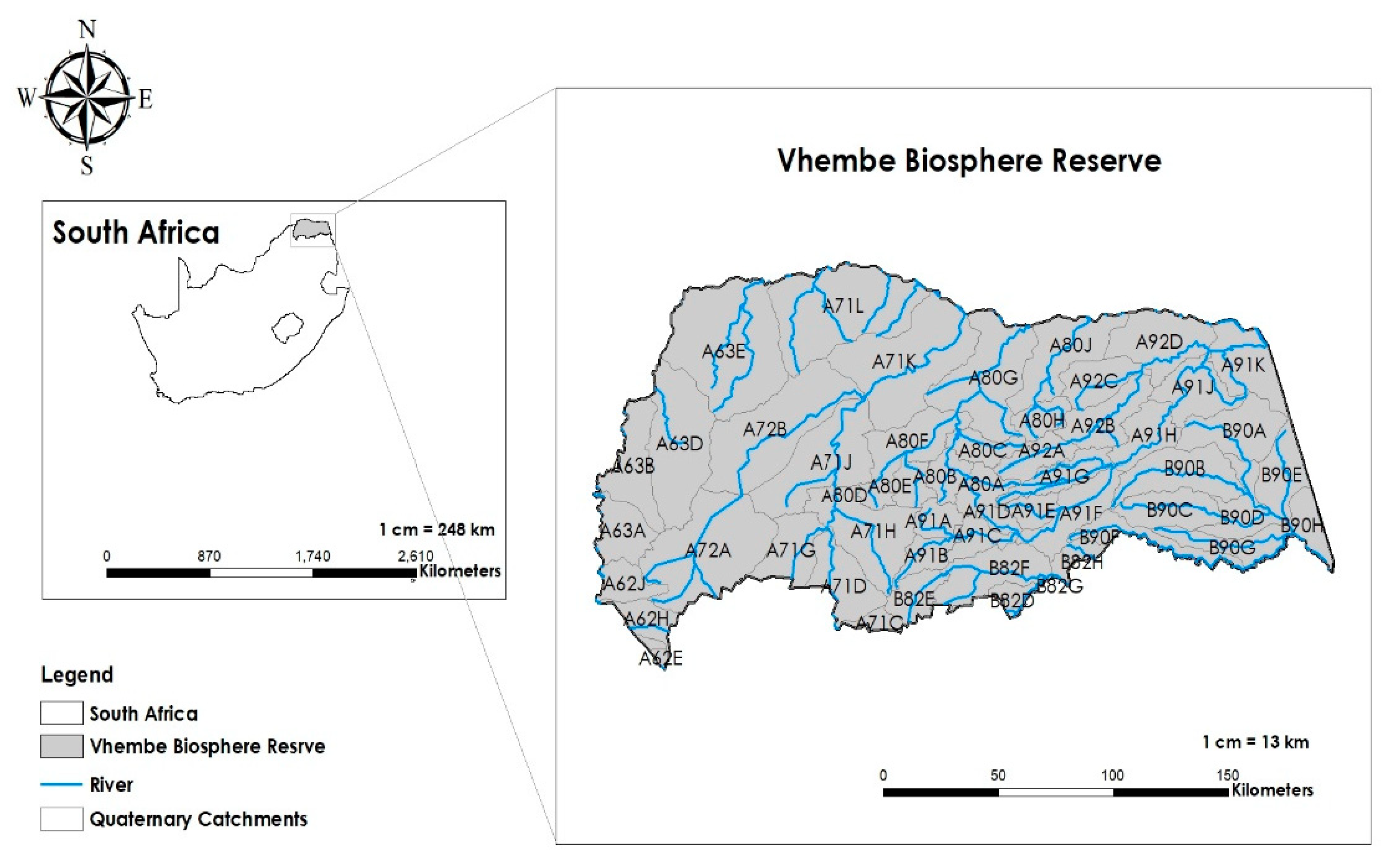
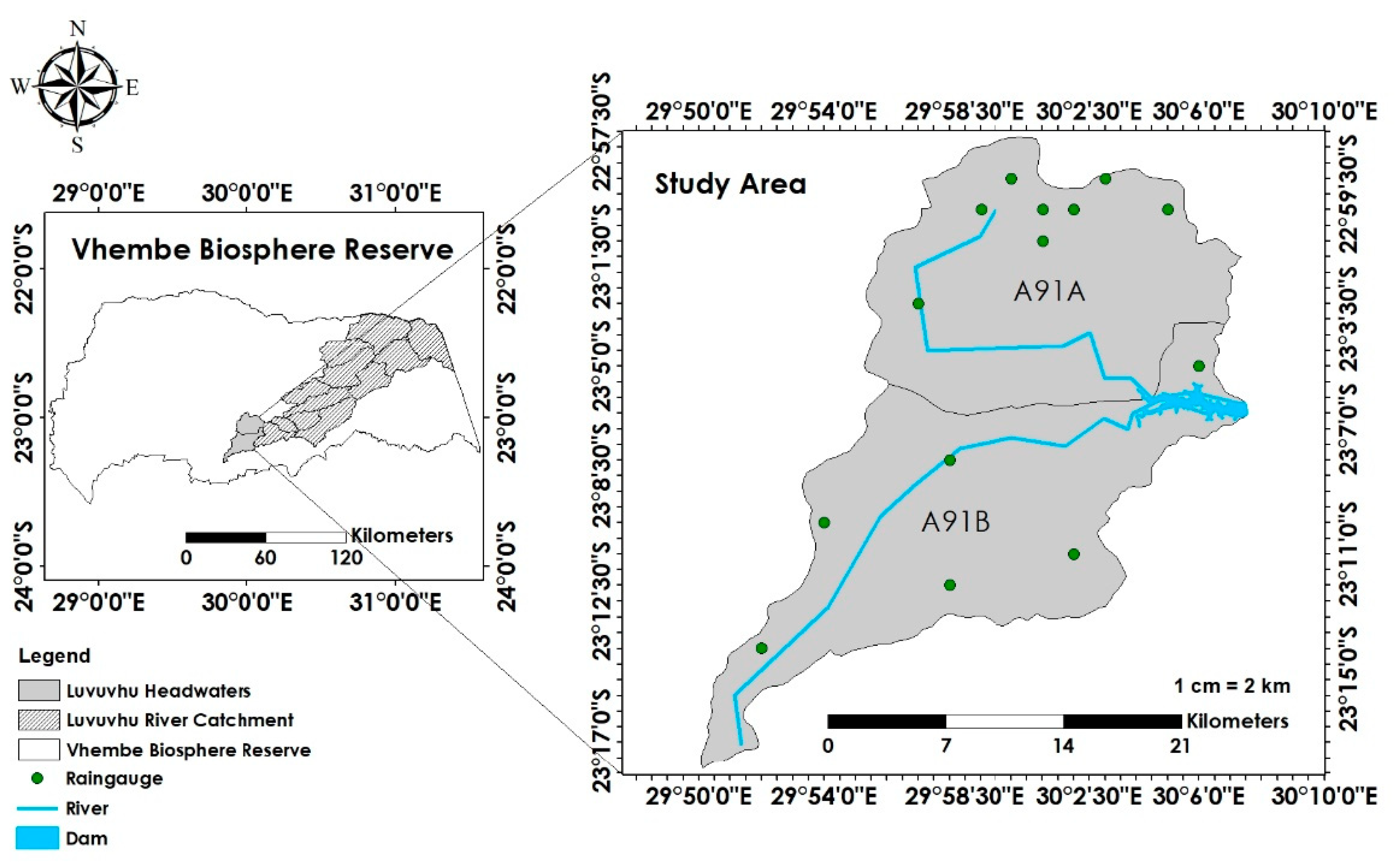
2. Study Area
3. Materials and Methods
3.1. Systematic Review
3.2. Exploratory Factor Analysis
3.3. Expert Opinions
3.4. GIS-Based Assessment and Ground-Truthing
4. Results
4.1. Systematic Review Results
4.2. Factor Scoring Analysis Results
4.3. Expert Opinion Findings
4.4. Findings of GIS Assessment and Ground-Truthing
5. Discussion
6. Conclusions
Author Contributions
Funding
Institutional Review Board Statement
Informed Consent Statement
Data Availability Statement
Conflicts of Interest
References
- De Bruin, W.B.; Morgan, M.G. Reflections on an interdisciplinary collaboration to inform public understanding of climate change, mitigation, and impacts. Proc. Natl. Acad. Sci. USA 2019, 116, 7676–7683. [Google Scholar] [CrossRef] [PubMed] [Green Version]
- Meehl, G.A.; Zwiers, F.; Evans, J.; Knutson, T.; Mearns, L.; Whetton, P. Trends in Extreme Weather and Climate Events: Issues Related to Modeling Extremes in Projections of Future Climate Change. Bull. Am. Meteorol. Soc. 2000, 81, 427–436. [Google Scholar] [CrossRef] [Green Version]
- Swain, D.L.; Wing, O.E.J.; Bates, P.D.; Done, J.M.; Johnson, K.A.; Cameron, D.R. Increased flood exposure due to climate change and population growth in the United States. Earth’s Future 2020, 8, 1–17. [Google Scholar] [CrossRef]
- Niang, I.; Ruppel, O.C.; Abdrabo, M.A.; Essel, A.; Lennard, C.; Padgham, J.; Urquhart, P. Africa. In Climate Change 2014: Impacts, Adaptation, and Vulnerability. Part B: Regional Aspects. Contribution of Working Group II to the Fifth Assessment Report of the Intergovernmental Panel on Climate Change; Cambridge University Press: Cambridge, UK, 2014. [Google Scholar]
- International Panel on Climate Change (IPCC). Summary for policymakers. In Climate Change 2014: Impacts, Adaptation, and Vulnerability. Part A: Global and Sectoral Aspects. Contribution of Working Group II to the Fifth Assessment Report of the Intergovernmental Panel on Climate Change; Core Writing Team, Pachauri, R.K., Meyer, L.A., Eds.; Cambridge University Press: Cambridge, UK; New York, NY, USA, 2014; pp. 1–32. [Google Scholar]
- Thomas, K.; Hardy, R.D.; Lazrus, H.; Mendez, M.; Orlove, B.; Rivera-Collazo, I.; Roberts, T.; Rockman, M.; Warner, B.P.; Winthrop, R. Explaining differential vulnerability to climate change: A social science review. WIREs Clim. Change 2019, 10, 1–18. [Google Scholar] [CrossRef] [Green Version]
- Phuong, L.T.H.; Wals, A.; Sen, L.T.S.; Hoa, N.Q.; Phan Van Lu, P.V.; Biesbroek, R. Using a social learning configuration to increase Vietnamese smallholder farmers’ adaptive capacity to respond to climate change. Local Environ. 2018, 23, 879–897. [Google Scholar] [CrossRef]
- Baudoin, M.A.; Ziervogel, G. What role for local organisations in climate change adaptation? Insights from South Africa. Reg. Environ. Change 2017, 17, 691–702. [Google Scholar] [CrossRef]
- McKenzie, M. Climate change education and communication in global review: Tracking progress through national submissions to the UNFCCC Secretariat. Environ. Educ. Res. 2021, 27, 631–651. [Google Scholar] [CrossRef]
- Adenle, A.A.; Ford, J.D.; Morton, J.; Twomlow, S.; Alverson, K.; Cattaneo, A.; Cervigni, R.; Kurukulasuriya, P.; Huq, S.; Helfgott, A.; et al. Managing Climate Change Risks in Africa—A Global Perspective. Ecol. Econ. 2017, 141, 190–201. [Google Scholar] [CrossRef] [Green Version]
- Tumushabe, J.T. Climate Change, Food Security and Sustainable Development in Africa. In The Palgrave Handbook of African Politics, Governance and Development; Oloruntoba, S., Falola, T., Eds.; Palgrave Macmillan: New York, NY, USA, 2018. [Google Scholar]
- Ziervogel, G. Building transformative capacity for adaptation planning and implementation that works for the urban poor: Insights from South Africa. Ambio 2019, 48, 494–506. [Google Scholar] [CrossRef] [Green Version]
- Filho, W.L.; Balogun, A.L.; Olayide, O.E.; Azeiteiro, U.M.; Ayal, D.Y.; Muñoz, D.C.; Nagy, G.J.; Bynoe, P.; Oguge, O.; Toamukum, N.Y.; et al. Assessing the impacts of climate change in cities and their adaptive capacity: Towards transformative approaches to climate change adaptation and poverty reduction in urban areas in a set of developing countries. Sci. Total Environ. 2019, 692, 1175–1190. [Google Scholar] [CrossRef]
- Frederick, K.D.; Major, D.C. Climate Change and Water Resources. Clim. Change 1997, 37, 7–23. [Google Scholar] [CrossRef]
- Anthony, F. Potential climate change impacts on water resources in the Auckland Region (New Zealand). Clim. Res. 1999, 11, 221–245. [Google Scholar]
- Zhang, C.; Sun, L.; Han, T.; Wan, X.; Jiang, Y. Climate Change Impacts on Water Resources and Ecological Environment of Inland Watersheds in the Hexi Region of West Gansu, China. In Proceedings of the 2009 International Conference on Management and Service Science, Beijing, China, 20–22 September 2009; pp. 1–4. [Google Scholar]
- Nóbrega, M.T.; Collischonn, W.; Tucci, C.E.M.; Paz, A.R. Uncertainty in climate change impacts on water resources in the Rio Grande Basin, Brazil. Hydrol. Earth Syst. Sci. 2011, 15, 585–595. [Google Scholar] [CrossRef] [Green Version]
- Estrela, T.; Pérez-Martin, M.A.; Vargas, E. Impacts of climate change on water resources in Spain. Hydrol. Sci. J. 2012, 57, 1154–1167. [Google Scholar] [CrossRef]
- Gayar, A.E.; Hamed, Y. Climate Change and Water Resources Management in Arab Countries. In Recent Advances in Environmental Science from the Euro-Mediterranean and Surrounding Regions; Advances in Science, Technology & Innovation (IEREK Interdisciplinary Series for Sustainable Development); Kallel, A., Ksibi, M., Ben Dhia, H., Khélifi, N., Eds.; Springer: Cham, Switzerland, 2018. [Google Scholar]
- Tramblay, Y.; Llasat, M.C.; Randin, C.; Coppola, E. Climate change impacts on water resources in the Mediterranean. Reg. Environ. Change 2020, 20, 1–3. [Google Scholar] [CrossRef]
- Greenwood, D.; Zhang, K.; Hilton, H.; Thompson, A. Opportunities for improving irrigation efficiency with quantitative models, soil water sensors and wireless technology. J. Agric. Sci. 2010, 148, 1–16. [Google Scholar] [CrossRef] [Green Version]
- Beven, K. How to make advances in hydrological modelling. Hydrol. Res. 2019, 50, 1481–1494. [Google Scholar] [CrossRef] [Green Version]
- Chang, F.J.; Guo, S. Advances in hydrologic forecasts and water resource management. Water 2020, 12, 1819. [Google Scholar] [CrossRef]
- Swart, R.; Biesbroek, R.; Lourenco, T.C. Science of adaptation to climate change and science for adaptation. Front. Environ. Sci. 2014, 2, 1–8. [Google Scholar] [CrossRef] [Green Version]
- UNESCO. Vhembe Biosphere Reserve, South Africa. 2021. Available online: https://en.unesco.org/biosphere/africa/vhembe (accessed on 5 November 2021).
- Hedden-Dunkhorst, B.; Schmitt, F. Exploring the potential and contribution of UNESCO Biosphere Reserves for landscape governance and management in Africa. Land 2020, 9, 237. [Google Scholar] [CrossRef]
- Dinku, T. Challenges with availability and quality of climate data in Africa. In Extreme Hydrology and Climate Variability; Assefa, M.M., Wossenu, A., Gabriel, S., Eds.; Elsevier: Amsterdam, The Netherlands, 2019. [Google Scholar]
- Roth, V.; Lemann, T.; Zeleke, G.; Subhatu, A.T.; Nigussie, T.K.; Hurni, H. Effects of climate change on water resources in the upper Blue Nile Basin of Ethiopia. Heliyon 2018, 4, e00771. [Google Scholar] [CrossRef] [PubMed] [Green Version]
- Gumbo, A.D.; Kapangaziwiri, E.; Chikoore, H.; Pienaar, H.; Mathivha, F. Assessing water resources availability in headwater subcatchments of Pungwe River Basin in a changing climate. J. Hydrol. Reg. Stud. 2021, 35, 1–13. [Google Scholar]
- Nel, J.; Colvin, C.; Le Maitre, D.; Smith, J.; Haines, I. South Africa’s Strategic Water Source Areas; CSIR/NRE/ECOS/ER/2013/0031/A; WWF-South Africa: Pretoria, South Africa, 2013. [Google Scholar]
- Nel, J.L.; Le Maitre, D.C.; Roux, D.J.; Colvin, C.; Smith, J.S.; Smith-Adao, L.B.; Maherry, A.; Sitas, N. Strategic water source areas for urban water security: Making the connection between protecting ecosystems and benefiting from their services. Ecosyst. Serv. 2017, 28 Pt B, 251–259. [Google Scholar] [CrossRef]
- Crowe, S.; Cresswell, K.; Robertson, A.; Huby, G.; Avery, A.; Sheikh, A. The case study approach. BMC Med. Res. Methodol. 2011, 11, 100. [Google Scholar] [CrossRef] [PubMed] [Green Version]
- Ponelis, S.R. Using interpretive qualitative case studies for exploratory research in doctoral studies: A case of information systems research in small and medium enterprise. Int. J. Dr. Stud. 2015, 10, 535–550. [Google Scholar] [CrossRef] [Green Version]
- UNESCO. Biosphere Reserves in Africa. 2021. Available online: https://en.unesco.org/biosphere/africa (accessed on 8 November 2021).
- VBR. Vhembe Biosphere. 2021. Available online: https://www.vhembebiosphere.org/ (accessed on 8 May 2021).
- Oyinlola, M.; Whitehead, T.; Abuzeina, A.; Adefila, A.; Akinola, Y.; Fatai Anafi, F.; Farukh, F.; Jegede, O.; Kandan, K.; Kim, B.; et al. Bottle house: A case of transdisciplinary research for tackling challenges. Habitat Int. 2018, 79, 18–29. [Google Scholar] [CrossRef]
- Wiebe, K.; Robinson, S.; Cattaneo, A. Climate Change, Agriculture and Food Security: Impacts and the Potential for Adaptation and Mitigation. In Sustainable Food and Agricultur; Campanhola, C., Pandey, S., Eds.; Elsevier Inc.: Amsterdam, Netherlands, 2019. [Google Scholar]
- Heyard, R.; Hottenrott, H. The value of research funding for knowledge creation and dissemination: A study of SNSF Research Grants. Humanit. Soc. Sci. Commun. 2021, 8, 217. [Google Scholar] [CrossRef]
- Crane, T.A.; Roncoli, C.; Hoogenboom, G. Adaptation to climate change and climate variability: The importance of understanding agriculture as performance. NJAS—Wagening. J. Life Sci. 2011, 57, 179–185. [Google Scholar] [CrossRef] [Green Version]
- Malhi, Y.; Franklin, J.; Seddon, N.; Solan, M.; Turner, M.G.; Field, C.B.; Knowlton, N. Climate change and ecosystems: Threats, opportunities, and solutions. Philos. Trans. R. Soc. B 2020, 375, 1–8. [Google Scholar] [CrossRef] [Green Version]
- Regmi, K.; Jones, L. A systematic review of the factors—Enablers and barriers—Affecting e-learning in health sciences education. BMC Med. Educ. 2020, 20, 91. [Google Scholar] [CrossRef] [Green Version]
- Brocca, L.; Massari, C.; Pellarin, T.; Filippucci, P.; Ciabatta, L.; Camici, S.; Kerr, Y.H.; Fernandez-Preto, D. River flow prediction in data scarce regions: Soil moisture integrated satellite rainfall products outperform rain gauge observations in West Africa. Sci. Rep. 2020, 10, 1–14. [Google Scholar] [CrossRef]
- Pandya, U.; Patel, D.P.; Singh, S.K. A flood assessment of data scarce region using an open source 2D hydrodynamic modeling and Google Earth Image: A case of Sabarmati flood, India. Arab. J. Geosci. 2021, 14, 1–18. [Google Scholar] [CrossRef]
- De Paula, M., Jr.; Costa Silva, T.A.; Araújo, A.S.; Lacorte, G.A. Assessments of Bacterial Community Shifts in Sediments along the Headwaters of São Francisco River, Brazil. Conservation 2021, 1, 91–105. [Google Scholar] [CrossRef]
- Koch, J.C.; Sjöberg, Y.; O’Donnell, J.A.; O’Donnell, J.A.; Carey, M.P.; Sullivan, P.F.; Terskaia, A. Sensitivity of headwater streamflow to thawing permafrost and vegetation change in a warming Arctic. Environ. Res. Lett. 2022, 17, 044074. [Google Scholar] [CrossRef]
- Ramulifho, P.; Ndou, E.; Thifhulufhelwi, R.; Dalu, T. Challenges to Implementing an Environmental Flow Regime in the Luvuvhu River Catchment, South Africa. Int. J. Environ. Res. Public Health 2019, 16, 3694. [Google Scholar] [CrossRef] [PubMed] [Green Version]
- Hughes, D.A.; Kapangaziwiri, E.; Sawunyama, T. Hydrological model uncertainty assessment in southern Africa. J. Hydrol. 2010, 387, 221–232. [Google Scholar] [CrossRef]


| Search Protocol | Inclusion | Exclusion |
|---|---|---|
| Initial Google Scholar search | - English literature. | - Non-English. |
| - Peer-reviewed. | - Gray area. | |
| - Any region. | ||
| Title and abstract review | - Site selection of a study area/case study. | - Sight selection for project implementation, e.g., wind farm, landfill, solar. |
| - Climate research. | - Any other study. | |
| Study site description | - Field studies. | - Non-field studies. |
| - Areas specific studies. | - Non-area-specific studies. |
| Factor | Importance | |||
|---|---|---|---|---|
| Very | Just | Neutral | None | |
| Accessibility: ease of reach (near to the researcher). * | X | |||
| Need for human presence at the study site or beneficiation from the headwater catchment/s. | X | |||
| The presence of environmental phenomena to be quantified and understood. * | X | |||
| The rich biodiversity in the area. | X | |||
| Availability of hydrometeorological data of adequate quality and quantity. (Headwater catchments with missing or no observed time series were more critical than those with). | X | |||
| The economic value of the area. | X | |||
| Need to test a model or equipment (experimentation). | X | |||
| Past similar work has been carried out in the area. * | X | |||
| Availability of relevant literature. | X | |||
| Influence of expert opinion. | X | |||
| Communication barriers (with stakeholders). | X | |||
| Availability of (adequate) funding. * | X | |||
| Quaternary Catchment Name. | Accessibility: Ease of Reach (Near to the Researcher). | Need for Human Presence at the Study Site or Beneficiation from the Headwater Catchment/s. | The Presence of Environmental Phenomena to Be Quantified and Understood. | The Rich Biodiversity in the Area. | The Economic Value of the Area. | There Is No Similar Work Done in the Area. | Availability of Experts for the Area. | Availability of (Adequate) Funding. | No Streamflow Data Is Available. |
|---|---|---|---|---|---|---|---|---|---|
| A91A | ✓ | ✓ | ✓ | ✓ | ✓ | ✓ | ✓ | ✓ | ✓ |
| A91B | ✓ | ✓ | ✓ | ✓ | ✓ | ✓ | ✓ | ✓ | ✓ |
| A91D | ✓ | ✓ | ✓ | ✓ | ✓ | ||||
| A91G | ✓ | ✓ | ✓ | ✓ | ✓ | ✓ | |||
| A92A | ✓ | ✓ | ✓ | ✓ | ✓ | ✓ | |||
| A92C | ✓ | ✓ | ✓ | ✓ | ✓ | ✓ | ✓ | ✓ | ✓ |
Publisher’s Note: MDPI stays neutral with regard to jurisdictional claims in published maps and institutional affiliations. |
© 2022 by the authors. Licensee MDPI, Basel, Switzerland. This article is an open access article distributed under the terms and conditions of the Creative Commons Attribution (CC BY) license (https://creativecommons.org/licenses/by/4.0/).
Share and Cite
Gumbo, A.D.; Kapangaziwiri, E.; Mathivha, F.I. A Systematic Study Site Selection Protocol to Determine Environmental Flows in the Headwater Catchments of the Vhembe Biosphere Reserve. Int. J. Environ. Res. Public Health 2022, 19, 6259. https://0-doi-org.brum.beds.ac.uk/10.3390/ijerph19106259
Gumbo AD, Kapangaziwiri E, Mathivha FI. A Systematic Study Site Selection Protocol to Determine Environmental Flows in the Headwater Catchments of the Vhembe Biosphere Reserve. International Journal of Environmental Research and Public Health. 2022; 19(10):6259. https://0-doi-org.brum.beds.ac.uk/10.3390/ijerph19106259
Chicago/Turabian StyleGumbo, Anesu D., Evison Kapangaziwiri, and Fhumulani I. Mathivha. 2022. "A Systematic Study Site Selection Protocol to Determine Environmental Flows in the Headwater Catchments of the Vhembe Biosphere Reserve" International Journal of Environmental Research and Public Health 19, no. 10: 6259. https://0-doi-org.brum.beds.ac.uk/10.3390/ijerph19106259