Smart Cities in Turkey: Approaches, Advances and Applications with Greater Consideration for Future Urban Transport Development


Department of Civil Engineering, Faculty of Engineering and Natural Sciences, Ankara Yıldırım Beyazıt University, Ankara 06010, Turkey
Energies 2019, 12(12), 2308; https://0-doi-org.brum.beds.ac.uk/10.3390/en12122308
Submission received: 26 April 2019
/
Revised: 5 June 2019
/
Accepted: 12 June 2019
/
Published: 17 June 2019
(This article belongs to the Special Issue Approaches, Advances and Applications in Sustainable Development of Smart Cities
)
Abstract
:The smart city transport concept is viewed as a future vision aiming to undertake investigations on the urban planning process and to construct policy-pathways for achieving future targets. Therefore, this paper sets out three visions for the year 2035 which bring about a radical change in the level of green transport systems (often called walking, cycling, and public transport) in Turkish urban areas. A participatory visioning technique was structured according to a three-stage technique: (i) Extensive online comprehensive survey, in which potential transport measures were researched for their relevance in promoting smart transport systems in future Turkish urban areas; (ii) semi-structured interviews, where transport strategy suggestions were developed in the context of the possible imaginary urban areas and their associated contextual description of the imaginary urban areas for each vision; (iii) participatory workshops, where an innovative method was developed to explore various creative future choices and alternatives. Overall, this paper indicates that the content of the future smart transport visions was reasonable, but such visions need a considerable degree of consensus and radical approaches for tackling them. The findings offer invaluable insights to researchers inquiring about the smart transport field, and policy-makers considering applying those into practice in their local urban areas.
1. Introduction
In this century more than ever, cities need to construct smart transportation approaches, advances, and applications with much higher consideration for future urban development [1,2,3,4] since only then can they suggest new desirable urban environments and prioritize the aspects that are most critical and vital for their future [5,6,7].
Today, the smart transport concepts seem to pay more attention towards offering ecological [8,9,10,11] and economic development [12,13,14,15] and quality of living products using the abilities of innovative technologies [16,17,18,19,20]—perhaps as, in the close future, these are more gainful and remarkable tasks to deliver [21]. The concept of smart transport has been recognized by Smith et al. [22], where a critical level of participation among its experts and community can lead to approval of a desirable future place to make joint and shared means of action. According to Michaelson and Stacks [23], a wide variety of members from the public, practitioners, and scholars should be involved to draw an assessment of desirable future endpoints.
Amongst all smart transportation strategies, ‘energy’ is always paramount; that is why public and private companies play a chief role in future smart design [24,25,26,27,28]. On the other hand, smart transport is not only about energy and technology, but there are different combinations of applications, advances, and approaches that build the concept of future urban development.
Many different combinations of these applications exist in many worldwide cities—e.g., Adelaide, Amsterdam, Barcelona, Boston, Columbus, New York, San Francisco, Shanghai, Singapore, Tokyo, and Vienna—which goes together with these knowledge-based economic, ecological, and technological development efforts [29,30,31,32].
More recently, however, an increasing number of Turkish cities and metropolitan areas face a wide range of urban transport challenges from serious environmental illnesses, weak local governance, and a lack of efficient infrastructure [33,34]. Designing more efficient urban transport systems by using energy and technological solutions becomes more complex and uncertain when countless urban transport challenges emerge in growing Turkish cities due to a steady rise in urban population and in car-ownership [35,36]. Alternative visions can suggest aspirational ideas for the current transport challenges [37,38] and demonstrate a pathway of measures for future urban development [39,40]. However, until now there has not been academic research in Turkey that shows the role of vision assessments for smart transport urban development. It is obvious that if the reliability of smart future alternatives (and their implications of the pathways for the desired ones) are not explored and analyzed, then the existing urban transport challenges will remain in our urban environments. Therefore, the objective of this paper is to demonstrate the importance of vision developments and their justifications by a range of stakeholders involved in the implementation of future Turkish urban development. In addition, providing a great involvement process across the range of public, expert, and decision-makers is a primary target of urban policy development in this paper. Therefore, the intention was to gather a huge number of individuals from different geographic locations, different transport mode users, and diverse perspectives to design an efficient framework that integrates public engagement in future smart policy development.
Section 2 reviews the existing literature addressing smart transport approaches, advances, and applications. Section 3 details the theoretical framework for the research design, while Section 4 presents the main results are as follows: (a) public desires in scenario formation and (b) examples of changes to typical Turkish urban streets. Section 5 analyzes the reliability of the visions, according to the believability of key driver changes for alternative futures and the reactions of different transport mode users on the visions. Section 6 discusses how the targets of one desirable vision could be reached from the future to the present. Section 7 discusses and concludes the paper.
2. Smart Transportation Approaches, Advances and Applications
In the rapidly growing literature, there are countless smart transport definitions/descriptions—focusing on separate characteristics of key drivers or outcomes [41,42,43,44,45]. These are coined by researchers, practitioners, and government and international organizations and are generally vague or inchoate in conception [46]. However, there is not a commonly agreed explanation of smart transport cities [47]. Several various initiatives are now being implemented in different parts of the world. For example, ‘ride sharing’ is probably one of the most well-known implications. Private ride-sharing companies like Uber and Lyft have already introduced this mode of transportation, with more accessible services for using the high-occupancy vehicle lanes and providing more affordable costs for people [48]. Similarly, ‘car-sharing applications’ link drivers and passengers in real-time and offer alternative and easier transport journeys [49]. ‘Smartphone mapping applications’ show nearby cycling sharing systems and public cycling systems and increase convenience for users to see how many cycles are available at each station [50]. ‘GPS-based route information on public transport’ offers real-time GPS tracking from mobile devices thus optimizes public transportation journeys and thus increases the reliability of public transportation services [51]. The inclusion of ‘traffic management’ approaches provides great solutions to minimize traffic congestion [52]. ‘Connected traffic signal’ creates increased driving safety and fuel efficiency by re-arranging the current state of traffic lights and how they will change [53]. Another initiative is a sensor tracking system like a Radio-Frequency Identification (RFID) device, which shows parking availability within a paid meter on the street that can be visualized on a map [54].
The existing worldwide projects demonstrate that smart transportation city applications are frequently implemented in developed countries by various methods, but these interventions show prominent variances compared to different locations. For example, the United States Department of Transportation has submitted a grant of $40 million to provide support for the implementation of smart transport city ideas for their cities [55,56]. The Austin city council project includes an autonomous transport service provider from the airport to the nearby smart stations [57]. Columbus has decided to design towards expanding existing electric infrastructure and converting public vehicle fleets to electric and hybrid vehicles [58]. The Denver City Council has incorporated the data management ecosystem from several sources to provide a real-time picture of public and private transportation journeys and launched an electronic autonomous shuttle service along a one-mile route distance [59]. Detroit’s smart city proposal includes new improved bus system [60] and a mobile application that maps out routes for users of public transport [61]. The New York City initiative includes a series of city service kiosks in the Link NYC network such as; free Wi-Fi, phone calls, device charging stations, local wayfinding, etc. [62]. In Pittsburgh, traffic light control systems are equipped to identify transit and freight vehicles and allow these vehicles to pass through the traffic lights quicker [63,64]. Portland has deployed building traffic sensors [65] and installed technology in fleet vehicles that can receive and transmit traffic condition data [66]. San Francisco uses wireless sensors to detect parking-space occupancy for a dynamic parking system that adjusts the cost of parking prices [67] and thereby reducing the time people spend looking for parking and avoiding distracted driving that disrupts pedestrians and cyclists [68].
The European Union (EU) has devised extensive use of transport city strategies to achieve a smart urban future for its metropolitan city-regions [69,70]. Amsterdam, for example, has improved smart street lighting which allows county municipalities to manage the brightness of streetlights [71]. These flexible traffic lights monitor dynamic traffic flow and provide information about existing travel patterns on a certain road to determine the best routes for different commuters [72]. Barcelona has made great strides in implementing information technology to reduce energy consumption and local emissions and in designing a new public bus network, utilizing primarily vertical, horizontal, and diagonal routes with several interchanges [73]. Bristol seeks to increase cycling mode share by 40% [74]. Kyiv Smart City initiative contains GPS trackers, installed on all public transportation fleets to decide favourable strategies for further infrastructural, technological and social development of the city in urban transport management [75]. The Kyiv Resident Card provides access to many local innovations and for all types of public transportation in the city [76]. The London Congestion Research Programme concluded that the city’s economy would benefit from a congestion charge scheme by the restriction of private cars in central London [77] and by the introduction of extra on-street parking restrictions in the outer areas of the city [78]. In Vienna, all the subway lines, tram and bus routes are navigable through smartphone application updates for commuters [79].
In Asia, many Chinese and Indian cities launched smart cities missions to transform their cities into smarter and citizen-friendly local areas [80,81,82]. For, instance, in Indian cities, the smart systems assess real-time traffic information, particularly for emergency cases [83,84,85,86,87]. Shanghai’s smart city mission focused on smart sensors in all buses and metro stations and the development of higher internet connection speeds have allowed increasing the productivity of the city [88,89]. Singapore has implemented several smart transportation initiatives, including an intelligent transport system, environmentally friendly transport, traffic management, smart airport initiatives, and driverless shuttle bus services [90,91]. For example, a shuttle bus service with 600 passengers per day was implemented by the Nanyang University of Technology in Singapore [92]. In Seoul, all the metro line systems are integrated with RFID and Near-Field Communication (NFC) for automatic ticket payment, helping customers to get their tickets with their smartphones [93,94]. Tokyo uses the ‘Internet of Things’ to design a safe and reliable rail network system and reduce the cost of maintenance closures [95]. In Australia, Adelaide’s city council has evolved a more integrated network of villages in which the central business district is fed by outer suburbs [96,97].
Several African and South American cities have also started to work towards designing smart and modern transportation systems [98,99]. The Benin City transportation systems were upgraded with an advanced ITS system that assesses traffic flow in real time [100]. Medellín has implemented the sharing of transportation data between the different types of mass transit for providing a quick solution for unexpected shifts in the volume of passengers and massification of routes [101,102].
These are just some approaches, applications, and advances in how most developed cities are utilizing their innovative smart transportation strategies. It is obvious that the smart city innovations to date are evidently limited to developed regions and smart information knowledge from one city might not be properly transferrable to another city because of differences in human and technological frameworks, land-use, and transport patterns [10,11,12,13,14,15,16,17,18,19,20,21,22,23,24,25,26,27,28,29,30,31]. Considering these worldwide initiatives, Turkey is undoubtedly far behind in smart transportation city development [33,34,35,36,37,38,39]. There needs to be a lot of progress to create smart transportation initiatives in Turkish cities and it seems that the major problems faced by the cities in adoption of smart systems are lack of quality public transportation, road safety concerns, poor traffic management, lack of modal options and funding, and poor public transportation [103]. Although, a range of civil society activities was recently set up to energize planning, transport, and environmental authorities to develop strategies to promote smart systems, including The CityFix Turkiye, EkoIQ, Wrisehirler, and Embarqturkiye [104,105,106,107,108,109,110], there is still a small body of projects that are concerned with smart transport applications in Turkey [111]. In addition, a few good smart approaches, advances, and applications have been made in current practice, and these initiatives have been implemented by the central government, with public engagement being excluded from evidence, knowledge, debate, and the policy-making developments [112,113]. There is a relatively small body of literature that is concerned with the reliability of future transport visions in smart city development. Therefore, it is still not known whether the aspirational thinking of achieving desirable futures in Turkish urban areas could be workable. Thus, this paper seeks to add to the body of knowledge on the development of smart transport futures, thereby contributing to understanding the requirements to propose a radical change in future and imagination of archetypal areas inside a simulated Turkish transport environment. Together, this paper provides important insights on determining local policy actions and strategies to support policymakers in achieving their local objectives.
In addition, many international studies [114,115] have shown that smart transportation approaches, advances, and applications allude to deficits in a theoretical base and methodology. For example, much of the smart transport studies are limited to comprehensive public involvement. The previous studies on the ensuring of public involvement are not reliable [58,59,60,61,62,63,64,65,66,67,68,69]. Despite the emerging recognition that an organized involvement of stakeholders should become central to all the relevant features of smart transportation studies [70,71,72,73,74,75,76,77,78,79,80,81,82,83,84], limited attention has been paid to encouraging different stakeholders in all critical stages of smart city agendas [85,86,87,88,89,90,91,92,93,94,95,96,97,98,99,100,101,102]. Furthermore, visions are composed of several vital drivers and not all the key drivers are of similar desirability [115] and reflecting nuances of value-laden perspectives by separating different clusters of desirability makes it more distinctive to comprehend complex futures [116,117]. Just as two different urban areas do not have the same pathway for success, each area must construct their pathways to achieve the future targets based on a series of joint reflections, desires, and considerations [118,119,120]. The generalizability of much smart transport research on this issue is problematic. Although extensive research has been carried out on smart transport studies, the previous studies are not compatible with sustainability principles [121,122,123,124] and are not representing the interconnected mechanism of a desirable future through systemic relationship [71,72,73,74,75,76,77,78]. A more systematic approach would include main methodological principles of smart transport studies, in terms of providing public involvement in future urban transport development [125,126,127,128,129], developing systemic features of smart transport cities [130], establishing futures based on the concept of sustainability [114,115,116,117,118,119,120,121,122,123,124,125,126], as well as using 3D visualization techniques [131].
3. Methodology
The combination of several research methods in the paper was conducted due to the complexity of future transport policy development. Consideration of previous research and practical constraints [114,115,116,117,118,119,120,121,122] led to the development of a three-stage approach, with the engagement of the public, experts, and policy-makers a critical influence at all stages: (i) extensive online comprehensive survey; (ii) semi-structured interviews; and (iii) participatory workshops.
The visions were initially created through public outputs amongst the volunteers of the comprehensive online survey study and a series of extensive discussions, project meetings, and presentations with the members of the İstanbul Metropolitan Urban Design and City Planning Office. At the first round of these extensive meetings, Computer-Aided Design (CAD) and 3D modelling software were used to design archetypal components of an imaginary hypothetical Turkish urban area, but our survey findings from the online survey were also considered. Then, a visual description of each component for the current and future year was created along with the accompanying scenario narrative of the context in the next meeting. For each vision, visual images and scenario narratives were improved primarily based on the survey outcomes, with a very distinctive environmental, energy, urban change and transport mode-share context, though all with a radical restriction in private car use relative to current-time Turkish cities. Further meetings were organized to obtain feedback on the believability of our possible alternatives and their context. In the semi-structured interviews with the previous volunteer participants, the imaginary representations of each vision and their scenario assumptions were demonstrated to justify the reliability of alternative Turkish futures, according to imaginary descriptions and background assumptions of the visions and the travel behaviours of different mode users amongst the volunteer survey participants. The semi-structured interview was designed as a step to investigate what actions for the further stage might be required for smart development, rather than estimating real Turkish transportation future. In the last stage, a series of participatory workshops were organized to bring a group of experts and local and national policymakers (and a considerable number of the public from the previous stages) together to construct policy clusters and pathways for achieving the target of one specific vision in different geographical locations. The purpose of local workshops was to explore how one of the more desirable visions in this paper could be adapted to different local circumstances and how to create policy pathway measures across several Turkish cities from the present day to 2035.
To ensure that the above techniques could be carried out competently, the determination of stakeholders depended on the following criteria:
- (i)
- “Public,” including participants from different demographic and socio-economic groups and various mode choice transport users (pedestrians, cyclists, public transport users, drivers, and shop-owners). Recorded mailing lists from local associations were used to identify and select participants from this group in each case study city.
- (ii)
- “Experts” with different experiences in the smart transport field, including urban planners, transport engineers, architects, civil engineers, academics, and civil society organizations. Recorded mailing lists were used from several Turkish professional companies, associations, and institutions to recognize participants.
- (iii)
- “Policymakers,” national and local transportation experts across five selected Turkish local municipalities (Ankara, Eskişehir, İzmir, İstanbul and Konya) to construct a timeline for the implementation of measures for their city.
3.1. An Extensive Online Comprehensive Survey
Setting up an efficient online email system for sourcing and recruiting research participants is the most appropriate way when the authors can quickly get access to lists of potential participants and the targeted participants in such lists already have an affiliation with an institution or sector [132]. E-mails were initially sent to only a portion of the people on the lists of potential participants. To get a higher participation response rate, the authors made several adjustments to the recruitment letters, then sent the revised letter to a different group of people on the long list of people to contact. The criteria for the urban location and stakeholder categories in which potential participants live were set out in the recruitment letter (see Section 3). A summary of the survey findings appears at this link: http://www.bisikletizm.com/bisikletli-ulasim-nasil-gelisebilir/ by clicking Anket Sonuçları.
A comprehensive research survey was conducted from March to June 2014 by using an online survey programme. The online survey link was sent to approximately 75,000 participants from the e-mail lists obtained from several Turkish public and private sectors. A total of 1135 people agreed to participate, and they were given a choice to provide their contact information for a possible follow-up interview and policy-development workshops. The main questions being addressed were how participants visualize their desirable futures. What are the expectations of participants regarding future smart transport visions? What are the key factors affecting the public choice of travel mode? What are the suitable policy measures to help achieve smart Turkish transport visions?
The socio-economic features of the participants are demonstrated in Table 1. Females accounted for 28.9% of participants, and males 71.1%. The age breakdown was: 18–35 years old (68%); 36–55 years (27.6%); and 55+ (3.7%). Less than a third (32%) indicated that they earn less than a €300 income per month, while 44% of the participants earn between €300 and €900. The remaining 24% earn over €1200 per month.
The survey text results were analyzed line by line and codes were assigned to the text. Then, the search for relations between conceptual survey texts and categories were examined. The goal was to understand possible drivers for smart transport developments in Turkey thoroughly. The critical changes in the vision development were categorized into four factors: (i) environmental solutions; (ii) technology; (iii) urban structure; and (iv) mode share. The scenario metaphors (see Section 4.1) and their visualizations (see Section 4.2) were mapped onto the possible Turkish urban areas designed, providing both a contextual description and associated generic representations of the vision storyline.
3.2. Semi-Structured Interviews
Semi-structured interviews offer a more open research process, where the interviewer has a series of general questions, as well as having some latitude to ask more detailed questions following up important issues. A total of 95 volunteer participants were asked to engage in the improvement and justification of the future visioning exercises through semi-structured interviews (see Table 2). Ninety-five in-depth interviews were conducted within the sample urban areas, and each semi-structured interview, based on a predefined guide, was designed to take about 15–25 min. The sample had a higher number of public participants (48), and the remaining participants were professionals (34) and decision-makers (13) (Table 2). The interview work was completed in spring and summer of 2015. Each interview consisted of seven open-ended questions for three smart transport visions in Turkey by 2035, according to the following structure: (i) what are the views of the participants about the visions? (ii) Are these visions desirable? (iii) Do participants think the visions are consistent with their internal expectations? (iv) What differences would participants like to see regarding these systems? (v) What should central and local governments do? (vi) What are the requirements for such future changes? Moreover, (vii) What are the uncertainties regarding the visions?
3.3. Workshop
The third stage of this study was operationalized through a series of five local policy construction workshops between January and April 2016. All policymakers involved in semi-structured interviews contributed to the local policy development workshop. The workshop size was between 25 and 30 people and this stage of the work mostly aimed to attract relatively senior participants from the local governments in each sample area and previous public and expert participants.
Each group were provided with samples of generic illustrations for specific visions in both a demonstration and in a hand-out. Further clarification was provided giving extended vision narratives for each vision (see Section 4.1). Questions to guide this clarification were asked as follows: what challenges exist for applying the strategies required for achieving the 2035 vision? For a specific vision, what policy measures will be implemented by 2020, 2025, and 2030? (for achieving the 2035 vision). The structuring of the qualitative data analysis process of the classification and the development of links between policy measures were simplified by using the NVivo (2.0) software programme.
4. Vision Development
The smart transport vision is future-oriented systems and offers urban mobility solutions for every individual [133,134,135]. The development of smart transport futures can be achieved through the Avoid-Shift-Improve (ASI) approach. These approaches are the most broadly adopted ways to deal with the challenges of existing urban transport systems [136,137]. Vision development is the result of a participatory process with a broad public, expert, and policy-maker involvement [23].
Figure 1 shows the most popular suggestions arising from 208 different responses from 1135 participants on designing future Turkish smart transport visions over the next two decades (see Appendix A). The most common factor is segregated cycle paths (72 participants), while the second highest measure was car speed reduction (53 participants). More cycling paths, restrictions for cars within the city centre, decreasing vehicle reduction, and the provision of pedestrian crossings are some of the other frequently described measures for the desirable future Turkish smart visions (Figure 1).
These were initially analyzed by text line, and relevant quotations assigned to nine different conceptual codes (special groups; public awareness; incentives; smart transport strategies; urban features; walking; cycling; public transport systems; and preventing car use) (see Appendix A).
Each of the visions presents futures for parts of an ideal Turkish urban area where dependence on green transport systems has been increased and where provision for private cars has been substantially restricted. The future smart transport alternatives are distinctly different from the main perspectives, such as the approach to environmental solutions, technological innovations, urban structure changes, and mode-sharing arrangements (see Table 3). The visions were established based on participant recommendations from the comprehensive survey data, quotations of the volunteer participants from the open-ended questions in the survey work (see Section 3.1), and extensive discussion with the members of the İstanbul Metropolitan Urban Design and City Planning Office team through a series of committee meetings and presentations.
The scenario development meetings were carried out in a fast-moving brainstorm form, and the outcomes do not provide a straightforward input to tools for transportation planning such as mathematical modelling, travel behaviour changes or computational sciences. Integrated participant suggestions and participants quotations were elaborately structured by filling in the empty cell in the example table presented in Table 3. It was then thought most appropriate to shape the process of scenario development of the visions with the members of the urban design and planning office team who could be acquainted with some of the urban transport practices of the development proposed.
4.1. Scenario Narratives
4.1.1. Avoid Vision
People are being encouraged to meet their basic needs online to decrease the length of automobile travel in urban areas. Various conveniences and promotional coupons are being provided for online shopping and bill payments. Widespread use of digital technology would cause a significant decrease in transport demand. High energy prices are not effective in decreasing automobile dependency because the price of public transportation would also go up. Dedicated walking and cycling lanes would promote more children and young people to use non-motorized systems to go to school. In this vision, similar and moderate increases are foreseen in all three types of smart transport systems relative to the existing poor infrastructure systems.
Technological innovations would be most improved to decrease possible accidents and to develop a more environmentally friendly transportation system. Additionally, Intelligent Speed Adaptation (ISA) is installed in new vehicles. Digital technology is viewed as a meaningful solution to reduce road accidents. People would do major activities and pay their bills via state online programmes. Some meetings would be carried out from home by work platforms. Follow-up work systems are being monitored and reported more rigorously than before; however, there may be some implications of home working on active lifestyles.
There are no significant changes taking place in the physical structure of cities. House prices in the city centre going up would make it harder to form compact cities. Strategies to either provide good street lighting or physically separate cyclists from vehicle traffic would be expected to improve road safety significantly. Strengthening road infrastructure with a concern for safety and penalizing drivers for not giving priority to pedestrians.
Traffic and driver education programs become an integral part of compulsory activities and courses in Turkish primary and secondary schools, to encourage safe and responsible behaviour either as a driver, cyclist, or pedestrian. There would be more traffic signs visible around schools and shopping malls. Drivers will be prohibited from driving over 30 km/h on the busiest streets in the urban areas. Local administrations would receive funding for making cycling or walking transportation safer and more attractive by implementing calming traffic measures. The investments are highly associated with the automotive and technology sectors.
4.1.2. Shift Vision
Local administrations would encourage the public to use non-motorized transport modes mainly due to air pollution problems. With the development of newly pedestrianized locations, a decrease is expected in car dependency, and so a decline in air pollution emissions is expected. New settlement areas close to decrease car dependency and make a broader range of people easily able to use non-motorized transport modes. Public buses are cheaper and more comfortable than the current situation and enable different income groups to access town centres easily. Walking and cycling have significantly increased, and car use has dramatically reduced.
Technological applications help make walking and cycling more convenient. Weather reports, events, health measurement equipment, public transportation stops, and route information are easily accessible. Most of the people consider that digital technology will obliterate social interaction and they do not want to move to home working or internet shopping entirely. City centres would be reachable through small cars that operate on renewable energy systems.
Growing petrol prices would increase employment densities and so lead to denser urban areas, although the effects of increasing petrol prices on some features of urban form are hard to forecast. However, the changes in urban form tend to happen very slowly because local land use strategies constrain increases in urban density. Municipalities warn residents to park their automobiles in a way that would not block pavements and cycle lanes. High parking prices and cycling awareness events encourage people to utilize cycling. More extensive areas are assigned to cyclists and pedestrians. Pedestrianization projects and running parks are becoming more common to increase people’s physical activity. Cycling and the integration of cycles with public transportation at transfer stations make cycling more appealing for different income groups.
Local administrations are encouraging cities to become more compact and multi-purpose. The pedestrianization of some locations in town centres offers significant advantages for the safe transport mode of cyclists and pedestrians. Denser urban areas would require automobiles to go slower, which in return helps to decrease possible accident risks in urban areas.
4.1.3. Improve Vision
Local administrations are trying to find efficient solutions for traffic jams and air pollution through a substantial reduction in car usage. Car drivers are encouraged to use workplace service buses or public transportation for their commutes. Car dependency shows the sharpest decline in this vision. Offering incentives to encourage the use of public transport options decreases the individual cost for such transport, and so encourages behavioural change. High energy demands would impose enormous hardships on private and public agencies in Turkey. The scarcity of energy resources will cause the price of fossil fuels to go up. Therefore, the government accepts the need to overcome the difficulty of procuring energy by investing in public transportation systems and by increasing awareness about sustainable energy. Supporting infrastructure developments have enabled public transport to become more convenient and people less dependent on car use compared to other visions.
A significant proportion of technological development consists of innovations regarding the improvement of fuel performance and economy. The new vehicles would operate on renewable energy that produces fewer emissions, or on electrical power. Technological developments will be limited, but city centres would be reachable through small cars that operate on renewable energy systems and would be integrated with cycles. Free-of-charge Wi-Fi systems spearhead public transportation systems, which are becoming a more practical transportation mode.
Local administrations are creating greenbelt areas to prevent city sprawl. The development of public transport would make new social and business locations in the outer parts of the city more appealing. The number of public transportation terminals would be increased in the outer parts of the city to increase accessibility. There would be a significant decrease in the number of severe accidents as drivers are encouraged to use public transportation services or non-motorized transport systems. Public transport drivers will be trained to be more aware of cyclists.
4.2. Visualizations
Three locations of the possible Turkish urban areas were designed as they were in 2015 in Figure 2. Specific archetypes used included a suburban area, an area close to a busy university campus, and part of the city centre. The residential area is a modern residential place to travel and live, but one where road parking is a crucial problem. The road is lacking the infrastructure to help pedestrians to cross the road safely and comfortably. There is a large taxi stand in the residential area, and unaffordable public transport links between the residential suburb and the outer locations of the city are the norm. The university campus is bound by a ring road, although beyond this, there was recent development such as scientific research and development centres and shopping areas. Pedestrian and bicycle access on the ring road are weak. The current roads for pedestrians and cyclists are narrow and uncomfortable. Illegal car parking along the road is common. A typical busy traffic corridor in the city centre has not successfully adapted to changing traffic circumstances over the years. The location is cluttered, and traffic congestion, noise, and local air pollution is the norm. The street lacks pedestrian infrastructure.
4.2.1. Avoid Vision
Avoid Vision decreases automobile dependency and proposes a more comfortable and safer active transportation system than the existing situation. Newly-arranged parking lanes prevent the pavement on the right side of the road being occupied by cars, enabling pedestrians to walk comfortably on the pavement. Measures to ease pedestrian use of the road have been implemented (Figure 3). In the new settlement areas, to reduce accident risks, suitable lighting systems improve the visibility of vulnerable road users. Properly placed barriers ensure safer cycling by separating the road from the motor vehicle. Cyclists can cross the road conveniently by using combined walking/cycling crossing places (see Figure 3). The fact that the cycle lane is to the left of the pedestrian walkway allows cyclists to travel faster. Some small-scale improvements have been made regarding the use of public transportation systems. There are reductions in available space for motor vehicles. Drivers are prohibited from driving over 30 km/h on the busiest streets, and greater enforcement is applied.
4.2.2. Shift Vision
Figure 4 shows the same three locations as in Figure 3 and how they may look in 2035 under Shift Vision. The prevention of new settlement areas at the edges of the city is approached in a planned manner. The changes in urban form tend to happen very slowly because local land use strategies constrain increases in urban density. People tend to move through certain parts of the urban centres closer to workplaces. Shift Vision presents a broader and more socialized location for the users of non-motorized vehicles. There are numerous social facilities, such as cafes and art galleries, which enable people to socialize. Pedestrianization projects and open space are more familiar to encourage physical activity. A separate road at the far end of the broad pedestrian area was designed for cyclists. The pedestrianization of residential areas offers an opportunity for safe cycling. Public information spots are placed at the nearby university to raise awareness of cycling. Public buses are cheaper and more comfortable than the current situation and enable different income groups to access town centres more efficiently. Denser urban areas force slower driving, which in turn helps reduce accident risk and severity.
4.2.3. Improve Vision
Figure 5 shows the same three locations as in Figure 3 and Figure 4 and how they may look in 2035 under Improve Vision. More affordable housing tends being encouraged in new developments with better transport connectivity and strong service provision, so it becomes increasingly possible for those on lower incomes and without an automobile to access jobs. Systems with pedestrian priority are designed, and roads for motorized vehicles are restricted. Road space is allocated to vulnerable roads users. There are more bicycle tracks for mainly recreational purposes in outer, natural areas of the city. Dedicated cycling lanes will pass behind bus stops, enabling cyclists to continue past a stationary bus, away from the traffic. Public transportation systems would become faster, more comfortable and will ensure that transportation to the city centre is less stressful. Public transport systems, school buses, and institutions’ service buses will cover 50% of the traffic in urban areas. Car dependency has the sharpest decline of the visions, and non-motorized transport increases by nearly 10%.
5. The Justification for the Visions
In general, participants stated that the core requirements for having active transport systems were explicitly considered in all three visions and all reduced the space available for cars to promote the development of smart transport.
As a public participant from İstanbul (Driver, male, aged 26–35) said “we need to adopt these alternative transportation visions anyway. It looks more and more like we cannot live. If we do not emphasize walking, cycling and public transport more, İstanbul will become a giant car park. Small cities are experiencing similar concerns as well.”
“A plan not having been made only for cyclists or only on the bus transport system. All transportation modes have been considered in a way to be balanced in different visions at the same time. One of the most neglected issues in our country is this. For example, if bicycle path is made, the place from where vehicles can go is not considered, or if one lane is removed, the places where cars will be parked are not taken into consideration”.(Expert, academy, female, aged 36–45, İstanbul)
Both experts and decision-makers asserted that the practices in Avoid Vision which improve the safety of people using different transport means would cause them to move to city centres rather than to suburban areas. In this vision, they said that it is not necessary for the car industry to invest more on safety in the presence of the improvements made to reduce accident risks, and there is no coordination between the municipalities and police units about speed control and fines due to a lack of inspection. Regarding Shift Vision, it was indicated that the variables created by the urban form could not be applied in Turkish cities because the growth of Turkish cities is dependent on unearned income in the construction industry. They advocated that radically reducing lanes is undefined as part of limiting the motorized vehicle traffic and expanding the areas for non-motorized vehicles will not increase socialization. They discussed the safety issue in Improve Vision, in which they stated that cycle accidents occurring in Turkish urban transportation are caused mostly by public buses, so bus drivers’ awareness of cycle users must be raised, but if this is not achieved, this vision may pose high accident risks.
In general, public participants who prefer to walk explained that Shift Vision is the more desirable vision because wider spaces for their needs may be easily supplied, especially near the university campuses. Many cyclists thought the reason why Avoid Vision is an ideal transportation system for them is that traffic rules guiding the relationship between cycling and walking are shown in a clearer manner. A lot of public transportation users found Improve Vision as a preferred future in all locations compared to the other visions. This is because fast and comfortable public transport systems are crucial for people to go to work (or school) in the early hours of the day. Driver participants generally thought that future visions should not be compelling because the closure of some settlement areas to traffic would increase traffic congestion in other streets. Therefore, they found Avoid Vision is more reliable for them as private cars are restricted less in the settlement area. Most shop owner participants oppose any future visions where private car users could not pull up in front of their stores. That is because they think their customers are always vehicle-using customers, whereas public transportation users usually use the roads in transit, but some of them think a vision where the public transportation system is improved may cause more customers to visit their store in outer suburbs.
The general opinion of the participants is that Avoid Vision seems like a transitional approach, Shift Vision can only be implemented in limited locations, and Improve Vision appears to be the most complicated approach and solution. In the paper, although future smart transport systems were initially developed with much higher dependence on walking and cycling, the results show that the vision that developed the public transport system the most was seen to be most realistic by the participants.
5.1. Environmental Solutions
The environmental solution address issues such as air pollution, noise, and congestion. Generally, public participants think that the most critical change is reducing traffic jams through the development of existing smart transport systems. In addition, the expert participants think that ‘‘motor vehicle lane does not need to be closed off too much because the roads closed off somewhere create more traffic congestion in other locations” and ‘‘walking distances increase too much with the closing of the areas and will cause stressful situations rather than minimizing traffic jam.”
“In Shift Vision, instead of closing off the motor road and creating a social area, such areas could be formed in different areas where the road does not pass. There are adequate society areas at the university. Thus, I think if we narrow down the roads and close them to traffic this could then pose problems”.(Driver, male, aged 18–25, Konya)
“Even three minutes is necessary for the condition of students being late for class in the morning. Improve Vision can offer fast transportation, and everyone can drop off at his or her faculty”.(Public transport user, female, aged 18–25, İstanbul)
The participants thought that, especially in the early hours of the day, there is a need for more efficient and fast public transportation systems within the campus, and therefore, they said even though Shift Vision presents a better campus environment, this vision creates a stressful situation by increasing walking distances, particularly for the students. One expert (Urban planner, female, aged 36–45, İstanbul) thinks dedicated road space for public transportation systems will permit traffic to flow faster; otherwise, the effects of public transport vehicles stopping in narrow lanes will cause traffic stoppages.
5.2. Technology
Technology has advantages and disadvantages in reducing travel demand and is an essential factor for business and smart life. In Turkish cities where home working may be appropriate, and to design smart technologies into working life, the spread of smart and digital innovations can lead to a decrease in daily travel trips. Several public and expert participants think that the introduction of digital technology into working life is awkward for the whole of Turkey; and said that it could cause declines in one-to-one people interactions.
“You mentioned especially a scenario in which office works will be performed remotely. Is this an assumption? Is this an estimate? I wondered because of the subject in Turkey. It is likely for our cities, such as İstanbul and Ankara. Is it possible for the whole of Turkey?”.(Driver, male, aged 26–35, İstanbul)
“Life gets easier with increased information gathering opportunities by use of technology, online services cut down travels, but it would not be wrong to foresee a decrease in human and one-to-one interactions?”.(Transport planner, male, aged 36–45, Konya)
One policy-maker considers the fact that the automotive sector does not need to make significant investments for safer urban transport environments in Avoid Vision. The policy-maker (Local, female, aged 46–55, Ankara) stated ‘‘If speeding limits are decreased, the number of accidents will decrease. Death tolls in collision accidents will also decrease—no speeding. When there is no speeding, the driver can manage his safety. There are comfortable cars too. There is a new technology too. There are human-less drivers, sensitive pedestrian systems, but it seems like the automotive sector will not have to make these investments in this scenario.”
5.3. Urban Structure
Many of the experts interviewed in this study, tend to underestimate the importance of compact and high-density areas.
“Taking measures for traffic safety particularly in the cities and settlements, which are dominated by motorized transportation, will make them more attractive and useful. The escape to suburban areas with dense traffic will be stopped”.(Expert, transportation planner, male, aged 26–35, Konya)
“The presence of dense areas is preferred. What we have is not compactness; it is an unplanned density. Bicycle transportation, to be improved has come down to such a compact area level that it is a problem in itself”.(Expert, urban planner, female, aged 26–35, İzmir)
They highlighted that the Turkish economic strategy had driven urbanization for years and they said designing a compact urban area model is not possible with the current conditions unless the economic policies of the central government change.
“Creating a compact city is possible with these improvements only for a very extended period since the growth of Turkish cities is dependent on unearned income”.(Expert, academy, female, aged 36–45, Ankara)
“Economy policies of the central government should be changed significantly. The economic strategy of Turkey has driven urban development and construction for years”.(Expert, civil society organization, female, aged 26–35, Eskişehir)
Another public participant claimed that there is no need for vehicles inside the campus and therefore it should be a system that supports pedestrians and cyclists as in Shift Vision. “Universities need to be made into more social areas. It could be easier to convert these places into a human-oriented urban environment, compared to the city centres” (Public, pedestrian, female, aged 18–25, İstanbul).
Besides, several public participants said road spaces for cars had been limited too much in Shift Vision and that the need for cars is inevitable in some cases.
“Sometimes there can be a situation of having to reach a place in the university; therefore, I may need the car. The bags I need to carry are heavy, and our campus is large, so carrying them can be tough for me. It would also not be possible for me to bring in from the university entrance; therefore, there should be lanes for the vehicles. If the drivers want to make an interim stop, a problem can arise. Still, it looks like having a two-lane road is essential. Otherwise, there would be transportation problems”.(Driver, female, aged 36–45, İstanbul)
“In a city like İstanbul, where 15 million people live, I think it is tough to apply simple solutions. I believe Shift Vision limits freedom of travel for motor vehicle users too much”.(Driver, male, aged 56–65, İstanbul)
“When coming to the university, I continuously must bring in and take away things. There could be a one-way road as in Improve Vision, and more attractive social areas could be created within the university. I believe Shift Vision limits freedom of travel for motor vehicle users too much”.(Public transport user, male, aged 26–35, İzmir)
5.4. Mode Share
In general, participants think that Avoid Vision looks like a transitional vision in the short term, although they think this vision seems more reasonable since motor vehicles do not decrease as much as the other visions.
“In Avoid Vision, automobile numbers do not decrease so much; this vision looks like a transition point. It can be a transition point for urban areas in Turkey as well”.(Expert, academy, female, aged 26–35, Eskişehir)
“Avoid Vision might be more realistic because it decreases automobile dependency less. There is a more consistent lane reduction in Avoid Vision, and there isn’t a far-reaching reduction in the decreasing of traffic. It seems more reasonable since there is not as much lane reduction as Shift Vision and Improve Vision”.(Expert, transportation engineer, male, aged 36–45, İstanbul)
The expert participants think that Shift Vision is not an alternative future that can be applied everywhere in different parts of typical Turkish urban areas, whereas it can be successfully implemented in certain parts of urban areas where motor vehicles are rarely restricted from entering the streets such as; narrow roads, campus areas, and historical places.
“Some areas might be said that vehicles should get out, and just pedestrians and cyclists should be allowed. It could especially be historic urban centres. So, all three visions may have different application areas. For example, Shift Vision can be considered in some regions of the city where there are more bicycle and pedestrian transportation, and where some motor vehicles cannot enter some streets. It can be applied in city centres and university campuses, but it is not a vision that could be implemented to every location of Turkish urban areas”.(Expert, urban planner, female, aged 26–35, Ankara)
Improve Vision prioritizes public transportation more, and that is why it seems more logical for the existing urban transport problems.
“All three visions are meaningful but the vision that prioritizes public transportation includes the other visions more, and that is why it seems more logical. Especially three types of smart transportation futures are brought together. It shows it includes public transportation”.(Expert, civil society organization, female, aged 36–45, Eskişehir)
“Improve Vision seems an ideal vision since you suggest more complex transportation in the city centre as well. Improve Vision can also promote people to mass transport and can decrease the problems they live in daily transport. Otherwise, if we do not give more importance to public and active transport systems, İstanbul will be transformed into a big car park area”.(Expert, academy, male, aged 36–45, İstanbul)
The participants emphasized that the economic strategy of Turkey is mostly dependent on the income-oriented building industry, so it is not convenient to design a compact urban model, as proposed in Shift Vision. Besides this, it was underlined that the spread of digital technology would lead to a decrease in communication between people in Avoid Vision. Additionally, they specified under the title of technology that producing smaller cars and lowering their carrying capacity in Shift Vision is in contrast with the environmental objectives and this approach can create disadvantages regarding fuel consumption, operating costs and conditions, traffic safety, and traffic jams.
5.5. The Response of Different Groups
5.5.1. Pedestrians
Participants preferring pedestrian transportation discussed that even though they liked the fact that in Avoid Vision, infrastructure systems were developed to support pedestrians’ safety, this vision was more designed for motor vehicle users. It has been expressed that, rather than having car park arrangements on the main road, with each school having their car park area independent of the main road, wider pavements could be allocated for pedestrians.
“In Avoid Vision, with making car-parking on the roadside, a less comfortable area was created for pedestrians. Instead of that, by setting up a car park arrangement within each school, wider pavements for the pedestrians should be created. For example, people want to walk when going to the cafeteria and in Avoid Vision, instead of the place allocated for the car park, widening the pavement could be more reasonable”.(Id514, pedestrian, male, aged 36–45, İzmir)
Additionally, it was stated that the creation of a more people-oriented urban environment near the university would be easier compared to any location in the city centre. Many of the participants said universities have a young, student population, and traffic designs that are more social and people-oriented, as in Shift Vision, would be reasonable.
“No need for vehicles inside the campus. One and two of every 100 people coming to the university provide for their transportation with their cars. In other areas, there should not be any need for a car. In the inner sections, the pavements need to be wide. University is especially a place where young people and studies are plenty; therefore, as well as walking will not pose a significant difficulty, it would also enable carrying out physical activities”.(Id229, pedestrian, male, aged 18–25, Ankara)
5.5.2. Cyclists
Cyclists stated that in Avoid Vision, crossovers were shown more clearly and that in Shift Vision, conflicts between cyclists and pedestrians could happen. Another participant expressed that pedestrian and bicycle transportation could be more compatible. As both are slow transportation modes, it is better for them to go from the same place. In addition, the barriers to prevent automobiles violating the pavements, and the public transportation vehicles would not strike bicycles in the right and left turns.
“In Avoid Vision, it is clearer on which side of the road bicycles and pedestrians can go across. In Shift Vision, it is not very clear, through where the bicycle path could go. For example, two different bicycle paths intersect at the midpoint of the road, and the bicycle path is provided over a single alternative track. It looks like at some points on the road; traffic confusion can arise between the bicycles and pedestrians. In Avoid Vision, providing a means for the bicycle and pedestrian ways to cross the road in a parallel way made it logical”.(Id723, cyclist, male, aged 26–35, İstanbul)
5.5.3. Public Transport Users
Public transport users think Shift Vision limits freedom of travel for motor vehicle users too much. Improve Vision, on the other hand, both provide a faster transportation system by allocating separate roads for buses and offers a better urban area for bicycle and pedestrian transportation users as well.
“Improve Vision has allocated single lanes and separate roads for public transportation; therefore, there also will be no chaos among the motor vehicles. For example, buses stopping at the bus stops to take in embarking passengers will not reduce the automobile’s speed. At the same time, there will be less vehicle traffic in this area”.(Id1011, public transport user, male, aged 26–35, Konya)
On the other hand, another participant maintained that because there is not much traffic at the university, a single-lane bus road could be adequate.
“In Shift Vision, not having any vehicles would create problems. It does not seem possible that this could be implemented. As there will not be too much traffic in the university, having the single-lane road of Improve Vision could be adequate. In the existing campus, there needs to be a road line surrounding the university on the outside”.(Id553, public transport user, male, aged 36–45, Konya)
5.5.4. Drivers
Drivers generally consider residential areas to be transit regions for accessing main traffic roads and therefore, in the event of the road being closed off as in Shift Vision, traffic problems could arise in other streets. They believe that existing infrastructure systems are not adequate for helping people to use public transportation systems. The infrastructure system should be made adequately prevalent so that then the conditions can arise for people to use public transportation systems rather than their cars.
“Many people have cars, and even though they know about traffic congestion, they do not want to use public transportation systems. That’s because these systems cannot provide for comfortable transportation in the present situation. Instead of that, they prefer to travel with their cars even though they know of the traffic congestion. To the extent, public transportation systems are accessible, comfortable and cheap; people would quit using automobiles”.(Id193, driver, male, aged 36–45, Ankara)
Some car drivers said that the single-lane public transport road could create difficulties in its implementation because of minibuses and municipality buses race among themselves to take on passengers at the university. They also argued that Avoid Vision provides at the same time, adequate areas for the cyclists and pedestrians as well. Within the university, providing for transportation for the students with ring trips could not pose a problem, but for those who are coming to the university for the techno-city, like mentioned, or those coming to meet their various needs, Improve Vision could cause problems.
“Sometimes there can be a situation of having to reach a place in the university; therefore, I may need the car. The bags I need to carry are heavy, and our campus is large, so carrying them can be tough for me’’.(Id612, driver, female, aged 26–35, Ankara)
“It would also not be possible for me to bring in from the university entrance; therefore, there should be lanes for the vehicles. If the drivers want to make an interim stop, a problem can arise. Still, it looks like having a two-lane road is essential. Otherwise, there would be transportation problems”.(Id452, driver, male, aged 36–45, İstanbul)
“In Shift Vision, passages for vehicles have been limited too much. When coming to the city centre, I continuously must bring in and take away things”.(Id062, driver, female, aged 36–45, Konya)
5.5.5. Shop Owners
Shop owners expressed that narrowing the road in the city centre for car users would create great disadvantages for them. It has been observed that the participants, with their customers being car users, on the other hand, use city centre streets in transit and therefore they would prefer to Avoid Vision such a manner that car users could still pull by their shops.
“The cars not being able to park means our business also being impacted to a significant level. That’s because our customers are vehicle-using customers. Public transportation users use this road in transit. Our customers are car drivers, meaning not flowing customers”.(public transport users) (Id312, shop owner, male, aged 56–65, İstanbul)
“If the road becomes a single-lane, it would create significant problems for the tradesmen. I do not think it’s appropriate to reserve this much pavement for the pedestrians. That’s because if vehicle traffic is not adequate, the vehicles could not park and if they want something from the tradesmen, they cannot buy it. The city centre roads still need to be two lanes. I mean it must be two-way and two-lanes. For this system to be realized, car parks need to be made underground, or pockets will be done here. If it is single-lane, when the cars stop, the cars behind will wait”.(Id216, shop owner, male, aged 46–55, Ankara)
“If automobile drivers cannot stop where they want to stop, it is definite that the businesses of the tradesmen will be very seriously impacted. Because of the renovation on this side, I have a daily €150 loss. No vehicle driver can pull up by the retail area”.(Id823, shop owner, male, aged 56–65, Eskişehir)
6. Policy Implications for Improve Vision
This section serves as a useful tool for helping future Turkish cities to understand how they might build their local policy pathways. As stated in Section 3.3, workshop participants were supplied with related resources (generic visualizations and the scenario statements for Improve Vision), in advance of each workshop, to discuss and create pathways with the context of their urban areas, as presented in Table 4.
We intended to identify distinctive policy measures that each sample needs to implement for achieving the target of one specific vision. Twenty-six participants were selected from across the selected urban samples: five from Ankara, Eskişehir, İzmir, and Konya, and six from İstanbul. It is interesting to mention that all selected urban areas in this study would have to apply different vital strategies to achieve their vision targets and that these local policy pathways could constitute exemplary approaches for many other Turkish cities. Meanwhile, it was noticed that the municipalities make their transport plans as part of their visions since the effect of the central authority on the local administrations is not strongly effective and satisfactory. It is somewhat surprising that the prominent smart transport practices of some Turkish urban areas are not applied, and the policy measures of each selected city can suggest important ideas for other cities.
6.1. Ankara
The first policy package for Ankara is to investigate new financial support for the construction of new metro lines (Keçiören and Airport) and increase the capacity of the metro and public transportation systems (especially in the direction of Çayyolu). As of the year 2020, it needs to be ensured that cyclists, especially in their commute to the university, can travel in a manner that is integrated with the metro systems. For public transportation systems in Ankara to become integrated with cycles, firstly, cycling sharing systems in universities need to be activated, and there needs to be cycling parking areas, especially in the metro stations by the universities. In 2025, there would be aims to increase the number of public transportation users with the improvement of price and physical integrations in all the public transportation systems through intelligent card systems. Then, the last phase was mapped to create a more comfortable pedestrianization area around some parts of the city centre by using high car parking charges.
6.2. Eskişehir
Eskişehir sets ambitious targets for the construction of new light rail infrastructure. In between 2015 and 2020, given significantly increasing numbers in public transportation systems, completion of the expansion of rail systems into three different areas (see Table 4) and the completion of the new cable car project should be planned. After the public transportation systems have a significant share in inner-city transport, on the roads where making cycle tracks were previously planned, these projects need to be put into operation. New cycle tracks need to be made into a continuous network, and after starting the operation of the new tramway line, bus services need to be brought to the neighbourhoods, where access to public transportation is still limited. Immediately after newly developed cycle networks, penalty proceedings would be applied for vehicle users occupying bicycle paths. As of the year 2025, in turn, to increase the efficiency of public transportation systems, the traffic control centre needs to be established. Between 2030 and 2035, a new park and green area projects should be started for increasing the square of green areas per person.
6.3. İstanbul
In between 2015 and 2020, enhancing the connections of all transportation systems among themselves is the first stage for adopting Improve Vision in İstanbul. For example, the integration of cycle and sea transport and integrating the new airport with the rail systems of the city centre, are needed. Various ongoing underground and surface rail system projects should aim to be finished by the year 2020. For public transportation systems to be integrated with cycles in İstanbul, marine transport draws attention as a more feasible transportation mode in ensuring that integration. In the subsequent five years, activities directed at increasing the popularity of the cycling transport system in inner city transportation could be made. For example, to create different points of view regarding cycling transportation, different organizations and activities need to be activated at the same time. In addition, strengthening the connection of pedestrian transport with the coast and making cycle tracks, especially from these regions, are needed. After 2020, city zone applications must be arranged to create low-emission areas in the central parts of the city where motor vehicles are intense. By the year 2030, advances should be made which are directed at limiting car traffic in the Historic Peninsula. The aim of controlling traffic congestion in the Historical Peninsula in İstanbul would be reached by implementing optimum traffic congestion charges.
6.4. İzmir
It is initially advised that cycle tracks at the endpoints of the coastal road are not up to specific criteria and since there are dirt roads in these segments, cyclists cannot go at adequate speeds. Therefore, firstly the cycle tracks in these sections need to be widened according to the criteria before 2020. Then, on these expanded tracks, additional cycling sharing systems need to be placed, and in the next stage, cycling sharing systems need to be extended to the city’s inner sections. Additionally, to enable integration in the last stage especially, as of the year 2020, for the cycle tracks on the coastal road, vertical cycle tracks need to be constructed towards the central parts of the city. By 2025, these vertically extending cycle tracks, in turn, should relate to the inner sections, and on the roads in between the bus and metro stops in these inner sections, car parameter fees should be kept high. To enable the integration between cycles and public transportation in İzmir efficiently and comprehensively, firstly the integration of public transportation systems in district centres shall be ensured. In the subsequent stage, public transportation and cycling transportation shall be integrated at locations in the city’s inner sections. By 2030, for the realization of local policies directed at creating new social and business areas, some social and business activities in the Alsancak Region, where all activities of the city are collected, should be moved to the Bayraklı Region, which is situated in another central region of the city. Moreover, by the year 2030, the historic Kadife Castle locations would be transformed into a pedestrianized region. After 2030, it will be possible to start the construction of new railway systems since there is a vital tourism potential in the north (Bergama) and south (Ephesus) axes of İzmir.
6.5. Konya
In Konya, for Improve Vision to achieve its objective, in the first stage in the regions where the new university and the TOKİ residential projects are situated, new settlement areas need to be opened in the region. The public transportation facilities between the inner-city bus terminal and the Meram Medical School need to be developed. Additionally, in this time five-year period, in regions where bus operation costs show a deficit in inner city transport (new university and Toki residences), new areas open for settlement need to be created. The most important strategies that need to be realized by 2020 and 2025, on the other hand, are directed at increasing both the comfort and the capacity of public transportation systems along with the new routes and starting the construction stage of the new monorail project. In the steps following 2025, around 500 minibuses in the city centre will be removed from traffic. Then, with the removal of minibuses from the inner-city transfer, electronic fee systems in the public transportation systems will start to be used. In the determination of fees relating to the utilization of these systems, they should also be made to encourage the lower income segment to the public transportation systems. For public transportation to become modeless, perceived as a waste of time in the single centre city (journeys between different regions mostly run via the city centre route), developing social and business areas in some side-lined, and central parts of the city should be planned. After 2030, car parking prices in some busy streets of the city centre need to be high.
7. Discussion and Conclusions
This paper has outlined a participatory approach taken to designing future Turkish smart cities for the year 2035 which bring about a radical development in the level of green transport systems through the hypothetical Turkish urban areas.
The key message from our research is that switching much of the population to more active forms of transport for many journeys is entirely feasible, if such forms of transport are made accessible, comfortable, and can easily be integrated into the user’s daily routine. Most people recognize the visions are reliable and solutions to the existing challenges are clear but robust to implement because they require relatively radical development not only in the habits in which people travel but also in the structure and organization of urban development.
Through this methodological perspective, it is useful to create remarkable and practical outcomes to enable comparison at the local level and provide enough knowledge to inform the local planning and development decision-making processes to construct smart transport cities, and at the same time provide generation of more informed regional and national policies and relevant actions in achieving a future urban development. For example, the key strategy for Ankara is to integrate cycling with metro and public transport systems, particularly at university stations, and to develop new smart card systems for all public transportation systems, with new rights and benefits for minibus drivers (see Table 4). On the other hand, the integration between the public transport systems or any smart card system has not yet been established in Ankara, whereas, in the other sample areas, the smart card systems and the public transport integration applications were being used much earlier for promoting the use of affordable public transport systems. Eskişehir was a single sample urban area that collaborates with the general security of the town for preventing car parks in cycle lanes. The general security and transportation departments of Eskişehir collaborated to prevent car parking in cycle lanes; however, similar applications are not implemented in other cities. This collaboration is essential for many Turkish cities where cyclists cannot use their routes due to the occupation of cycle lanes by cars (even for Konya, which has 240 km of cycling paths). The policy agenda of İstanbul includes new underground and ground railway systems and to implement a traffic congestion charge. İstanbul provides an essential message to the other major car-dependent cities that it is crucial to initially develop public transport systems for changing public behaviour from car journeys into public transport systems and then to improve non-motorized transport systems (see Table 4). İzmir was the only city that does not allow minibuses to enter the city centre as a transport mode, but their commercial use between definite terminals in the suburban areas and the counties was allowed. This practical application may offer an excellent point to other municipalities that have high traffic congestion due to the intense use of urban minibuses in other urban areas. The topography and urban structure of Konya offers a better urban environment for cyclists and pedestrians. However, cars occupy many cycle lanes, and current pedestrian planning projects were terminated due to public pressure. Making the city centre more attractive for the public needs may promote car drivers to use more smart transport systems because people in Konya must use some central parts of the city for their long transit journeys (see Table 4).
The research results corroborate the findings of a great deal of the previous worldwide city council projects [72,73,74,75,76,77,78,79,80,81,82,83,84,85,86,87], which devised extensive use of public transport strategies to achieve future urban development. In the context of providing public engagement to smart transport city development [58,59,60,61,62,63,64,65,66,67,68,69], the paper has highlighted a novel feature to the participatory approach, relating to the meaningful public involvement with a variety of participant groups throughout the construction of the local policy-pathways. While most of the smart transport studies do not involve public engagement during the future urban development [115,116,117,118,119,120,121,122,123,124], this paper reveals that the effectiveness of the local transport policy development can be notably increased by combining complementary participatory methods [125]. For example, the survey process represented a more closed process, where public participants have meaningful input into the imaginary future scenario developments.
However, the overall findings of the current study do not support a great deal of previous research [57,58,59,60,61,62,63,64,65,66,67,68], which has demonstrated that many advanced cities have tended to give greater priority to push factors such as parking management measures, building traffic sensors, traffic light control systems, implementing road prices, etc. On the other hand, to improve the attractiveness of desired future urban systems, different Turkish cities initially need to achieve their reduction in private car use through a greater proportion of pull measures (i.e., improvement of metro and mass transportation systems, integration of bicycles into mass transportation, development of light railway systems), rather than push measures. This approach may be somewhat related to fast-growing cities and towns [103]. Non-motorized improvements such as designing the main centres of Turkish cities to provide priority to pedestrians, development of the integration of all mass transportation systems, increasing green fields per individual, strengthening pedestrian infrastructures, and more, can be considered as other examples of pull measures in Turkey (see Table 4).
Finally, to generate smart transport city development, a wide-ranging approach needs to be synchronized among a variety of different public and private sectors to create an urban environment in which choosing to use green systems becomes noticeable. Such coordination may seem idealistic or utopian, but they are undoubtedly still some distance from the present Turkish government action plan on smart city transport development. Undoubtedly, such developments would involve a considerable degree of consensus that such a future is achievable, that the existing transportation problems are real, and that radical approaches to tackling them are essential.
Funding
This research received no external funding.
Acknowledgments
I would like to thank many anonymous participants, without whom the questionnaire surveys, interviews, and workshops may not have been carried out.
Conflicts of Interest
The author declares no conflict of interest.
Appendix A

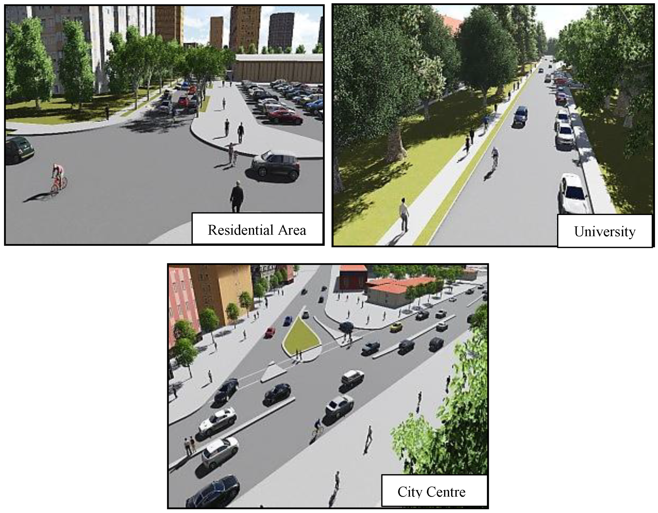
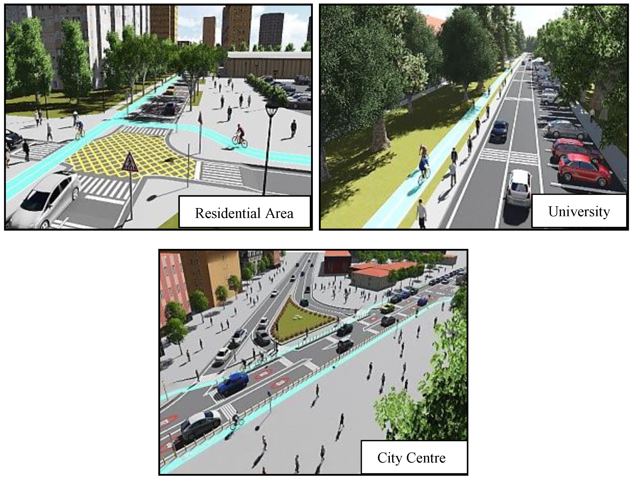
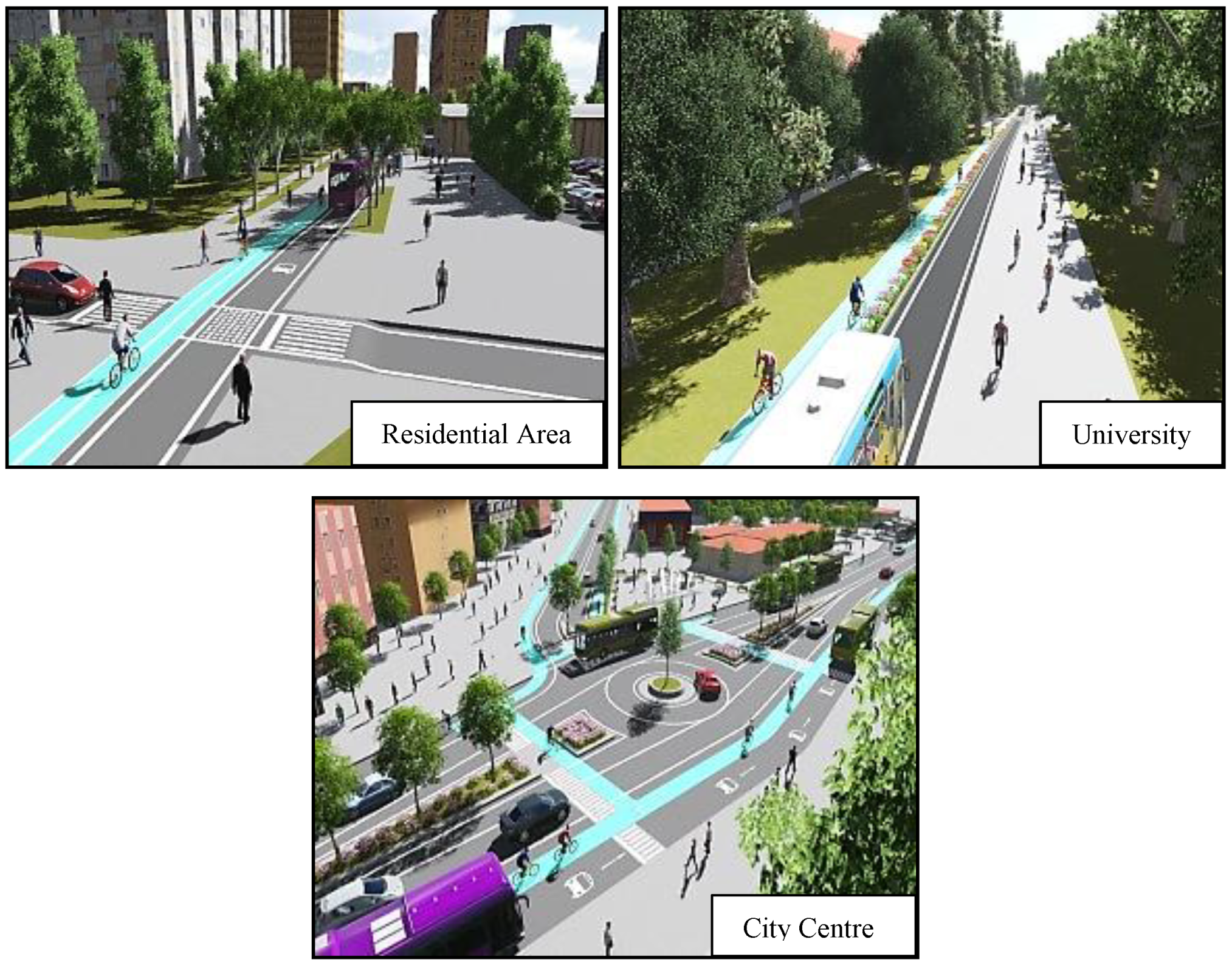
Table A1.
Preventing car use.
| Key Factor | Response Number |
|---|---|
| Reducing private car usage | 5 |
| In the city centre | 2 |
| Reducing vehicle speed | 53 |
| A limited parking ban in the city centre | 3 |
| Resolving parking problems | 4 |
| Increasing petrol prices | 7 |
| A reduction in the number of cars parked | 2 |
| Complicating car purchase | 1 |
| Making harder to get a car license | 1 |
| Speed control | 5 |
| In residential areas | 4 |
| City centre | 1 |
| Annual quota system for vehicle usage | 1 |
| Decreasing vehicle reduction | 35 |
| Restrictions for cars within the city centre | 43 |
| Designing small cars | 3 |
| Deceleration of private cars in the crosswalk | 1 |
Table A2.
Public transport systems.
| Key Factor | Response Number |
|---|---|
| Public transport | 25 |
| Better planned public transport system | 4 |
| Modern public transport systems | 2 |
| Increasing the number of public transport buses | 3 |
| Improving the quality of public transport services | 3 |
| Increasing public transport comfort | 1 |
| Improving public transport facilities | 1 |
| Intelligent public transport systems | 1 |
| Renewal of public transport vehicles | 2 |
| Upgrading public transport vehicles | 1 |
| Safer transport systems | 2 |
| More quiet transport systems | 2 |
| More enjoyable transport systems | 1 |
| Traffic management centre implements | 1 |
| Alternative systems | 2 |
| Intelligent road design | 3 |
| Smart design | 4 |
| Integrating cycling and public transportation | 9 |
| Technology advancements in public transport | 2 |
| Public transport users should respect each other | 1 |
| Reduced fare program | 2 |
| Minibuses | 1 |
| Tramway | 3 |
| Metro | 3 |
| Accelerating tram | 1 |
| Systematic road transportation systems | 1 |
| Increasing the frequency of time | 1 |
| Increasing the frequency of times during business hours | 2 |
| Public transport management service | 1 |
| Dissemination about public transport services | 2 |
| More accessible public transport systems | 1 |
| Increasing the share of renewable energy in public transport services | 1 |
| Route improvement project | 1 |
Table A3.
Cycling.
| Key Factor | Response Number |
|---|---|
| Lowering the price of bicycles | 2 |
| Dissemination on cycling awareness | 13 |
| Safe bike paths | 19 |
| Aesthetic bike paths | 1 |
| Bicycle lifts | 1 |
| Electric bikes | 1 |
| Bike hire | 2 |
| Separate bike paths | 72 |
| Expansion of bike paths | 2 |
| Safety strips | 1 |
| More bike paths | 44 |
| Comfortable bike lanes | 3 |
| Safe bicycle parks | 1 |
| Security cameras near bike parking space | 3 |
| Bicycle parking spaces | 30 |
| Warning signs at the junction | 2 |
| Do not allow pedestrians to walk on bike paths | 4 |
| Bicycle police | 1 |
| Signalized intersections | 2 |
| Traffic light priority for cyclists | 1 |
| Inserting helmet | 3 |
| Shower facilities | 2 |
| Improvement of bike paths | 4 |
| Creating complete bicycling networks | 6 |
| Better quality bike paths | 2 |
Table A4.
Walking.
| Key Factor | Response Number |
|---|---|
| Increasing pedestrian paths | 4 |
| Safe pedestrian paths | 2 |
| Expansion of pedestrian paths | 15 |
| Giving priority to pedestrians | 2 |
| Seat benches | 3 |
| Reduction of the defect in the pedestrian path | 2 |
| Comfortable pedestrian paths | 1 |
| Better pedestrian paths | 3 |
| More comprehensive pedestrian paths | 2 |
| Regular pavement | 1 |
| Better pedestrian infrastructures in suburban areas | 4 |
| Less waiting times for pedestrians | 1 |
| Tree-lined pathways | 1 |
| Prevention of invasion of pedestrian paths | 23 |
| By motor vehicles | 19 |
| By electric poles | 1 |
| By cyclists | 4 |
| Improvement of crossroads | 25 |
| Suburban areas | 3 |
| More comfortable bike pathways for elderly | 3 |
| More comfortable bike pathways for disabled | 2 |
| Encouraging walking | 1 |
| Pedestrian crossing | 31 |
| Pedestrian signs | 2 |
| Designing more direct routes | 6 |
| Walking maps | 4 |
| Facilitating pedestrian access in hilly areas | 2 |
| Street lighting | 8 |
| Running parks | 1 |
| Editing underpasses and overpasses on the roads | 3 |
| For pedestrians | 1 |
| For cyclists | 2 |
Table A5.
Urban features.
| Key Factor | Response Number |
|---|---|
| Increasing aesthetic | 16 |
| Park areas | 4 |
| Green areas | 5 |
| New modern squares | 4 |
| Visual beauty | 1 |
| More social and business places in residential areas | 3 |
| Urban design for family securities | 3 |
| More compact cities | 1 |
| Decreasing the population of major cities | 4 |
| By shifting into another city | 3 |
| Industries should be relocated outside of cities | 3 |
| Fixing distorted urban land | 2 |
| Improvement of urban environments | 2 |
| For better air quality | 1 |
| For decreasing noise pollution | 1 |
| City and regional planning for public | 1 |
| Ensuring security in the streets | 2 |
| Reduction of the population densities in major cities | 2 |
| Artistic places in major cities | 3 |
Table A6.
Sustainable transport strategies.
| Key Factor | Response Number |
|---|---|
| Cyclists should have more rights | 3 |
| Protecting all rights of pedestrians | 2 |
| Preventing society from crazy young drivers | 1 |
| Penalty sanctions | 4 |
| Each transport mode users should comply with traffic rules | 3 |
| Improving the conditions of cyclists | 2 |
| Increasing the rules | 1 |
| Arrangements about passenger cars | 3 |
| Development of traffic laws | 2 |
| Development of local sustainable transport policies | 4 |
| Development of national sustainable transport policies | 6 |
| Ensure the observance of traffic signs | 1 |
| More comprehensive bicycle strategies | 2 |
| Developing bicycle culture in urban areas | 1 |
| Prevention of invasion of bike paths | 6 |
| By pedestrian | 1 |
| By motor vehicles | 5 |
| Tax incentives for cyclists | 1 |
| Cycling license law | 2 |
| The application of deterrent sanctions | 1 |
| Improvement of pedestrian rights | 1 |
| Making mandatory the use of pedestrian crossings | 3 |
| Penalizing car drivers who do not respect cyclists | 1 |
| Penalizing car drivers who do not give way to pedestrians | 4 |
| Campaigns and education | 6 |
| Different cultural campaigns based on sustainable transport | 2 |
| Giving bike education in kindergarten | 1 |
| Improving municipal management for cities to succeed | 1 |
| Shifting investments to small towns | 1 |
| People should live in or near areas where jobs are concentrated | 1 |
Table A7.
Incentives.
| Key Factor | Response Number |
|---|---|
| Economic | 4 |
| For walking | 2 |
| For public transport | 4 |
| For decreasing passenger cars | 2 |
| For cycling | 1 |
Table A8.
Public awareness.
| Key Factor | Response Number |
|---|---|
| Related to walking and cycling issues | 3 |
| Increasing the awareness of bicycle use | 2 |
| Awareness of pedestrians | 1 |
| Awareness of motor vehicles | 4 |
| Towards using walking and cycling for short trips | 3 |
| Towards sharing roads with cyclists | 2 |
| Towards respecting pedestrians in the pedestrian crossing | 1 |
| Expert and public events towards dissemination of walking and cycling as transport modes | 3 |
| Public spots for increasing the awareness of pedestrians | 2 |
| Dissemination of cycling | 4 |
| Organized cultural events for cycling | 6 |
| Extraction of traffic laws that increase people’s consciousness | 1 |
| Increasing respect for pedestrians | 2 |
| Increasing respect for cyclists | 1 |
| Cyclists should have more rights | 6 |
| Protecting all rights of pedestrians | 1 |
| Organized cultural events for cycling | 5 |
| Cultural changes | 1 |
| People respect each other | 2 |
| Conscious and trained drivers | 1 |
| Prevention of unnecessary horn-blowing | 1 |
| Cultural innovation for a sustainable future | 3 |
| Public awareness | 1 |
| Training of public transport drivers | 4 |
| Solving social dimension problems | 6 |
| Giving importance to education | 2 |
| Health campaign for people using private vehicles | 1 |
| Training of people | 1 |
| Regular training | 1 |
| Granting of traffic education in schools | 1 |
| The public spot that expresses walking is good for heart health | 1 |
| Raise awareness about sustainable energy trends | 2 |
| Public spotlight on carbon emissions | 1 |
| Public spotlight on obesity | 1 |
| Raise awareness about sustainable energy trends | 1 |
| Public spotlight on carbon emissions | 1 |
| Education | 1 |
| Preventing society from crazy young drivers | 1 |
| Improving people attitudes towards less polluting public vehicles | 1 |
Table A9.
Special groups.
| Key Factor | Response Number |
|---|---|
| Convenience for families with babies | 2 |
| Providing safety for child and young cyclists | 3 |
| Encouraging low-income people to use cycle | 1 |
| Electric bikes for adults | 1 |
| Better systems for disabled people | 2 |
| Build a shelter for stray dogs | 1 |
References
- Bratzel, S. Conditions of success in sustainable urban transport policy change in relatively successful European cities. Transp. Rev. 1999, 19, 177–190. [Google Scholar] [CrossRef]
- Poister, T.H.; Streib, G. Elements of strategic planning and management in municipal government: Status after two decades. Public Adm. Rev. 2005, 65, 45–56. [Google Scholar] [CrossRef]
- de Roo, G. Integrating city planning and environmental improvement: Practicable strategies for sustainable urban development. Routledge 2017, 2, 47–340. [Google Scholar]
- Ding, G.K. Sustainable construction—The role of environmental assessment tools. J. Environ. Manag. 2008, 86, 451–464. [Google Scholar] [CrossRef] [PubMed]
- Lele, S.M. Sustainable development: A critical review. World Dev. 1991, 19, 607–621. [Google Scholar] [CrossRef]
- Sennett, R. Urban disorder today. Br. J. Social. 2009, 60, 57–58. [Google Scholar] [CrossRef]
- Dahly, D.L.; Adair, L.S. Quantifying the urban environment: A scale measure of urbanicity outperforms the urban-rural dichotomy. Soc. Sci. Med. 2007, 64, 1407–1419. [Google Scholar] [CrossRef] [PubMed]
- Zhang, X.; Hes, D.; Wu, Y.; Hafkamp, W.; Lu, W.; Bayulken, B.; Schnitzer, H.; Li, F. Catalyzing sustainable urban transformations towards smarter, healthier cities through urban ecological infrastructure, regenerative development, eco-towns and regional prosperity. J. Clean. Prod. 2016, 122, 4. [Google Scholar] [CrossRef]
- Geldenhuys, H.J.; Brent, A.C.; de Kock, I.H. Literature review for infrastructure transition management towards Smart Sustainable Cities. In Proceedings of the IEEE International Systems Engineering Symposium, Rome, Italy, 1–3 October 2018. [Google Scholar]
- Trindade, E.P.; Hinnig, M.P.F.; Moreira da Costa, E.; Marques, J.; Bastos, R.; Yigitcanlar, T. Sustainable development of smart cities: A systematic review of the literature. J. Open Innov. Technol. Mark. Complex. 2017, 3, 11. [Google Scholar] [CrossRef]
- Chang, D.L.; Sabatini-Marques, J.; Da Costa, E.M.; Selig, P.M.; Yigitcanlar, T. Knowledge-based, smart and sustainable cities: A provocation for a conceptual framework. J. Open Innov. Technol. Mark. Complex. 2018, 4, 5. [Google Scholar] [CrossRef]
- Khatoun, R.; Zeadally, S. Smart cities: Concepts, architectures, research opportunities. Commun. ACM 2016, 8, 46–57. [Google Scholar] [CrossRef]
- Komarevtseva, O.O. Smart city technologies: New barriers to investment or a method for solving the economic problems of municipalities? R-Economy 2017, 3, 32–39. [Google Scholar] [CrossRef]
- Höjer, M.; Wangel, J. Smart sustainable cities: Definition and challenges. In ICT Innovations for Sustainability; Springer: Berlin/Heidelberg, Germany, 2015; Volume 310, pp. 333–349. [Google Scholar]
- Eremia, M.; Toma, L.; Sanduleac, M. The smart city concept in the 21st century. Procedia Eng. 2017, 181, 12–19. [Google Scholar] [CrossRef]
- Letaifa, S.B. How to strategize smart cities: Revealing the SMART model. J. Bus. Res. 2015, 68, 1414–1419. [Google Scholar] [CrossRef]
- Djahel, S.; Doolan, R.; Muntean, G.M.; Murphy, J. A communications-oriented perspective on traffic management systems for smart cities: Challenges and innovative approaches. IEEE Commun. Surv. Tutor. 2015, 17, 125–151. [Google Scholar] [CrossRef]
- Ahvenniemi, H.; Huovila, A.; Pinto-Seppä, I.; Airaksinen, M. What are the differences between sustainable and smart cities? Cities 2017, 60, 234–245. [Google Scholar] [CrossRef]
- Yigitcanlar, T. Smart cities: An effective urban development and management model? Aust. Plan. 2015, 52, 27–34. [Google Scholar] [CrossRef]
- Yigitcanlar, T. Smart cities in the making. Intern. J. Knowl. Based Dev. 2017, 8, 201–205. [Google Scholar]
- de Oliveira, M.J.; Homrich, A.S.; de Mello, R.; Carvalho, M.M. Applying backcasting and system dynamics towards sustainable development: The housing planning case for low-income citizens in Brazil. J. Clean. Prod. 2018, 193, 97–114. [Google Scholar]
- Smith, A.; Stirling, A.; Berkhout, F. The governance of sustainable socio-technical transitions. Res. Policy 2005, 34, 1491–1510. [Google Scholar] [CrossRef]
- Michaelson, D.; Stacks, D.W. Standardization in public relations measurement and evaluation. Pub. Relat. J. 2011, 5, 1–22. [Google Scholar]
- Calvillo, C.F.; Sánchez-Miralles, A.; Villar, J. Energy management and planning in smart cities. Renew. Sustain. Energy Rev. 2016, 55, 273–287. [Google Scholar] [CrossRef]
- Ejaz, W.; Naeem, M.; Shahid, A.; Anpalagan, A.; Jo, M. Efficient energy management for the internet of things in smart cities. IEEE Commun. Mag. 2017, 55, 84–91. [Google Scholar] [CrossRef]
- Mosannenzadeh, F.; Bisello, A.; Vaccaro, R.; D’Alonzo, V.; Hunter, G.W.; Vettorato, D. Smart energy city development: A story told by urban planners. Cities 2017, 64, 54–65. [Google Scholar] [CrossRef]
- Zygiaris, S. Smart city reference model: Assisting planners to conceptualize the building of smart city innovation ecosystems. J. Knowl. Econ. 2013, 4, 217–231. [Google Scholar] [CrossRef]
- Kitchin, R. The real-time city? Big data and smart urbanism. GeoJournal 2014, 79, 1–14. [Google Scholar] [CrossRef]
- Yigitcanlar, T.; Kamruzzaman, M.; Buys, L.; Ioppolo, G.; Sabatini-Marques, J.; da Costa, E.M.; Yun, J.J. Understanding ‘smart cities’: Intertwining development drivers with desired outcomes in a multidimensional framework. Cities 2018, 81, 145–160. [Google Scholar] [CrossRef]
- Yigitcanlar, T.; Kamruzzaman, M. Does smart city policy lead to the sustainability of cities? Land Use Policy 2018, 73, 49–58. [Google Scholar] [CrossRef]
- Yigitcanlar, T.; Foth, M.; Kamruzzaman, M. Towards post-anthropocentric cities: Reconceptualizing smart cities to evade urban ecocide. J. Urban Technol. 2019, 26, 147–152. [Google Scholar] [CrossRef]
- Curtis, C.; Holling, C. Just how (Travel) Smart are Universities when it comes to implementing sustainable travel. World Transp. Policy Pract. 2004, 10, 22–33. [Google Scholar]
- Yousefi-Sahzabi, A.; Unlu-Yucesoy, E.; Sasaki, K.; Yuosefi, H.; Widiatmojo, A.; Sugai, Y. Turkish challenges for low-carbon society: Current status, government policies and social acceptance. Renew. Sustain. Energy Rev. 2017, 68, 596–608. [Google Scholar] [CrossRef]
- Balcı, V.; Özbek, O.; Koçak, F.; Çeyiz, S. Determination of the constraints of bicycle use in urban life Kent yaşamında bisiklet kullanım engellerinin belirlenmesi. J. Hum. Sci. 2018, 15, 35–50. [Google Scholar] [CrossRef]
- Uçar, A.; Şemşit, S.; Negiz, N. Avrupa Birliği Akilli Kent Uygulamalari ve Türkiye’deki Yansimalari. Suleyman Demirel Univ. J. Fac. Econ. Adm. Sci. 2017, 22, 1785–1798. [Google Scholar]
- Ayataç, H. Kentsel Ulaşım Planlaması ve İstanbul. İTÜ Vakfı Dergisi 2016, 71, 31–35. [Google Scholar]
- Akbulut, F. Kentsel Ulaşim Hizmetlerinin Planlanmasi ve Yönetiminde Sürdürülebilir Politika Önerileri. Kastamonu Üniversitesi İktisadi ve İdari Bilimler Fakültesi Dergisi 2016, 11, 336–355. [Google Scholar]
- Balaban, O. The negative effects of the construction boom on urban planning and environment in Turkey: Unraveling the role of the public sector. Habitat Int. 2012, 36, 26–35. [Google Scholar] [CrossRef]
- Berberoğlu, S.; Akın, A.; Clarke, K.C. Cellular automata modelling approaches to forecast urban growth for Adana, Turkey: A comparative approach. Landsc. Urban Plan. 2016, 153, 11–27. [Google Scholar] [CrossRef]
- Alphan, H. Land-use change and urbanization of Adana, Turkey. Land Degrad. Dev. 2003, 14, 575–586. [Google Scholar] [CrossRef]
- Papa, R.; Gargiulo, C.; Cristiano, M.; Di Francesco, I.; Tulisi, A. Less smart more city. TeMA J. Land Use Mobil. Environ. 2015, 8, 159–182. [Google Scholar]
- Basu, I. Elite discourse coalitions and the governance of ‘smart spaces’: Politics, power and privilege in India’s Smart Cities Mission. Polit. Geogr. 2019, 68, 77–85. [Google Scholar] [CrossRef]
- Paschek, F. Urban Sustainability in Theory and Practice-Circles of Sustainability. Town Plan. Rev. 2015, 86, 745. [Google Scholar]
- Hollands, R.G. Will the real smart city please stand up? Intelligent, progressive or entrepreneurial? City 2008, 12, 303–320. [Google Scholar] [CrossRef]
- Caragliu, A.; Del Bo, C.; Nijkamp, P. Smart cities in Europe. J. Urban Technol. 2011, 18, 65–82. [Google Scholar] [CrossRef]
- Brenner, N.; Schmid, C. The ‘urban age’ in question. Int. J. Urban Reg. Rese. 2014, 38, 731–755. [Google Scholar] [CrossRef]
- Gladwin, T.N.; Kennelly, J.J.; Krause, T.S. Shifting paradigms for sustainable development: Implications for management theory and research. Acad. Manag. Rev. 1995, 20, 874–907. [Google Scholar] [CrossRef]
- Jin, S.T.; Kong, H.; Wu, R.; Sui, D.Z. Ridesourcing, the sharing economy, and the future of cities. Cities 2018, 76, 96–104. [Google Scholar] [CrossRef]
- Shaheen, S.; Chan, N. Mobility and the sharing economy: Potential to facilitate the first-and-last-mile public transit connections. Built Environ. 2016, 42, 573–588. [Google Scholar] [CrossRef]
- Romanillos, G.; Zaltz Austwick, M.; Ettema, D.; De Kruijf, J. Big data and cycling. Transp. Rev. 2016, 36, 114–133. [Google Scholar] [CrossRef]
- Mintsis, G.; Basbas, S.; Papaioannou, P.; Taxiltaris, C.; Tziavos, I.N. Applications of GPS technology in the land transportation system. Eur. J. Oper. Res. 2004, 152, 399–409. [Google Scholar] [CrossRef]
- Dresner, K.; Stone, P. Multiagent traffic management: A reservation-based intersection control mechanism. In Proceedings of the Third International Joint Conference on Autonomous Agents and Multiagent Systems, New York, NY, USA, 19–23 July 2004; Volume 2, pp. 530–537. [Google Scholar]
- Goodall, N.J.; Smith, B.L.; Park, B. Traffic signal control with connected vehicles. Transp. Res. Rec. 2013, 2381, 65–72. [Google Scholar] [CrossRef]
- Rahman, M.S.; Park, Y.; Kim, K.D. Relative location estimation of vehicles in the parking management system. In Proceedings of the 11th International Conference on Advanced Communication Technology, Gangwon-Do, Korea, 15–18 February 2009; Volume 1, pp. 729–732. [Google Scholar]
- Geller, A.L. Smart growth: A prescription for liveable cities. Am. J. Public Health 2003, 93, 1410–1415. [Google Scholar] [CrossRef] [PubMed]
- Hall, R.E.; Bowerman, B.; Braverman, J.; Taylor, J.; Todosow, H.; Von Wimmersperg, U. The vision of a smart city. Brookhav. Natl. Lab. 2000, 5, 41. [Google Scholar]
- Segal, M.; Kockelman, K.M. Design and implementation of a shared autonomous vehicle system in Austin, Texas. In Proceedings of the Transp. Research Board 95th Annual Meeting, Washington, DC, USA, 10–14 February 2016; Volume 16, p. 1837. [Google Scholar]
- Barkenbus, J.N. Eco-driving: An overlooked climate change initiative. Energy Policy 2010, 38, 762–769. [Google Scholar] [CrossRef]
- Mogk, J.E.; Wiatkowski, S.; Weindorf, M.J. Promoting urban agriculture as alternative land use for vacant properties in the city of Detroit: Benefits, problems and proposals for a regulatory framework for successful land use integration. Wayne L. Rev. 2010, 56, 1521. [Google Scholar]
- Barbeau, S.J.; Borning, A.; Watkins, K. OneBusAway multi-region–rapidly expanding mobile transit apps to new cities. J. Public Transp. 2014, 17, 3. [Google Scholar] [CrossRef]
- Sinky, H.; Khalfi, B.; Hamdaoui, B.; Rayes, A. Responsive content-centric delivery in large urban communication networks: A LinkNYC use-case. IEEE Trans. Wirel. Commun. 2017, 17, 688–1699. [Google Scholar] [CrossRef]
- Möller, D.P.; Fidencio, A.X.; Cota, E.; Jehle, I.A.; Vakilzadian, H. Cyber-physical smart traffic light system. In Proceedings of the IEEE International Conference on Electro/Information Technology (EIT), DeKalb, IL, USA, 21–23 May 2015. [Google Scholar]
- Park, K.; Willinger, W. Self-Similar Network Traffic and Performance Evaluation; Wiley-Interscience: Hoboken, NJ, USA, 2000; Volume 4, pp. 21–52. [Google Scholar]
- Leontiadis, I.; Marfia, G.; Mack, D.; Pau, G.; Mascolo, C.; Gerla, M. On the effectiveness of an opportunistic traffic management system for vehicular networks. IEEE Trans. Intell. Transp. Syst. 2011, 12, 1537–1548. [Google Scholar] [CrossRef]
- Shaheen, S.A.; Mallery, M.A.; Kingsley, K.J. Personal vehicle sharing services in North America. Res. Transp. Bus. Manag. 2012, 3, 71–81. [Google Scholar] [CrossRef] [Green Version]
- Mathur, S.; Jin, T.; Kasturirangan, N.; Chandrasekaran, J.; Xue, W.; Gruteser, M.; Trappe, W. Parknet: Drive-by sensing of road-side parking statistics. In Proceedings of the 8th International Conference on Mobile Systems, Applications, and Services, San Francisco, CA, USA, 15–18 June 2010. [Google Scholar]
- Hayashi, H.; Inomata, R.; Fujishiro, R.; Ouchi, Y.; Suzuki, K.; Nanami, T. Development of pre-crash safety system with pedestrian collision avoidance assist. In Proceedings of the 23rd International Technical Conference on the Enhanced Safety of Vehicles, Seoul, Korea, 27–30 May 2013. [Google Scholar]
- Hull, A. Policy integration: What will it take to achieve more sustainable transport solutions in cities? Transp. Policy 2008, 15, 94–103. [Google Scholar] [CrossRef]
- Papa, R.; Gargiulo, C.; Galderisi, A. Towards an urban planners’ perspective on Smart City. TeMA J. Land Use Mobil. Environ. 2013, 6, 5–17. [Google Scholar]
- Gharaibeh, A.; Salahuddin, M.A.; Hussini, S.J.; Khreishah, A.; Khalil, I.; Guizani, M.; Al-Fuqaha, A. Smart cities: A survey on data management, security, and enabling technologies. IEEE Commun. Surv. Tutor. 2017, 19, 2456–2501. [Google Scholar] [CrossRef]
- Shahzad, G.; Yang, H.; Ahmad, A.W.; Lee, C. Energy-efficient intelligent street lighting system using traffic-adaptive control. IEEE Sens. J. 2016, 16, 5397–5405. [Google Scholar] [CrossRef]
- Roca-Riu, M.; Estrada, M.; Trapote, C. The design of interurban bus networks in city centres. Transp. Res. Part A Policy Pract. 2012, 46, 1153–1165. [Google Scholar] [CrossRef]
- Goodman, A. Walking, cycling and driving to work in the English and Welsh 2011 census: Trends, socio-economic patterning and relevance to travel behaviour in general. PLoS ONE 2013, 8, e71790. [Google Scholar] [CrossRef] [PubMed]
- Pozdniakova, A. Digitalization process in Ukraine as a prerequisite for the smart city concept development. Balt. J. Econ. Stud. 2017, 3, 14–19. [Google Scholar] [CrossRef]
- Hurkovskyy, V.I.; Mezentsev, A.V. International experience of applying of the electronic identification of citizens as a technological basis of electronic petitions: Organizational and legal aspects. Public Manag. 2017, 1, 63–73. [Google Scholar]
- Leape, J. The London congestion charge. J. Econ. Perspect. 2006, 20, 157–176. [Google Scholar] [CrossRef]
- Marsden, G. The evidence bases for parking policies—A review. Transp. Policy 2006, 13, 447–457. [Google Scholar] [CrossRef]
- Alpopi, C.; Silvestru, R. Urban development towards the smart city-a case study. Adm. Manag. Public 2016, 27, 107. [Google Scholar]
- Datta, A. New urban utopias of postcolonial India: ‘Entrepreneurial urbanization in Dholera smart city, Gujarat. Dialogues Hum. Geogr. 2015, 5, 3–22. [Google Scholar] [CrossRef]
- Joss, S.; Cook, M.; Dayot, Y. Smart cities: Towards a new citizenship regime? A discourse analysis of the British smart city standard. J. Urban Technol. 2017, 24, 29–49. [Google Scholar] [CrossRef]
- Kumar, T.V.; Dahiya, B. Smart Economy in Smart Cities; Springer: Singapore, 2017; Volume 11, pp. 3–76. [Google Scholar]
- Sundar, R.; Hebbar, S.; Golla, V. Implementing intelligent traffic control system for congestion control, ambulance clearance, and stolen vehicle detection. IEEE Sens. J. 2014, 15, 1109–1113. [Google Scholar] [CrossRef]
- Thakur, T.T.; Naik, A.; Vatari, S.; Gogate, M. Real-time traffic management using the Internet of Things. In Proceedings of the 2016 International Conference on Communication and Signal Processing (ICCSP), Madras, India, 6–8 April 2016. [Google Scholar]
- Radhakrishnan, P.; Mathew, T.V. Passenger car units and saturation flow models for highly heterogeneous traffic at urban signalised intersections. Transportmetrica 2011, 7, 141–162. [Google Scholar] [CrossRef]
- Marisamynathan, S.; Vedagiri, P. Modeling pedestrian delay at signalized intersection crosswalks under mixed traffic condition. Procedia-Soc. Behav. Sci. 2013, 104, 708–717. [Google Scholar] [CrossRef]
- Sharma, A.; Vanajakshi, L.; Rao, N. Effect of phase countdown timers on queue discharge characteristics under heterogeneous traffic conditions. Transp. Res. Rec. 2009, 2130, 93–100. [Google Scholar] [CrossRef]
- Cervero, R.; Day, J. Residential relocation and commuting behaviour in Shanghai, China: The case for transit-oriented development. US Berkeley Cent. Future Urban Transp. 2008, 2, 4–16. [Google Scholar]
- Wang, Y.; de Almeida Correia, G.H.; de Romph, E.; Timmermans, H.J.P. Using metro smart card data to model location choice of after-work activities: An application to Shanghai. J. Transp. Geogr. 2017, 63, 40–47. [Google Scholar] [CrossRef] [Green Version]
- Mega, V.P. Transport for Sustainable Cities. In Sustainable Cities for the Third Millennium: The Odyssey of Urban Excellence; Springer: Berlin/Heidelberg, Germany, 2010; Volume 11, pp. 61–74. [Google Scholar]
- Debnath, A.K.; Chin, H.C.; Haque, M.M.; Yuen, B. A methodological framework for benchmarking smart transport cities. Cities 2014, 37, 47–56. [Google Scholar] [CrossRef] [Green Version]
- Hoe, S.L. Defining a smart nation: The case of Singapore. J. Inf. Commun. Eth. Soc. 2016, 14, 323–333. [Google Scholar] [CrossRef]
- Liu, W.; Zhao, C.; Zhong, W.; Zhou, Z.; Zhao, F.; Li, X.; Fu, J.; Kwak, K. The GPRS mobile payment system based on RFID. In Proceedings of the International Conference on Communication Technology, Istanbul, Turkey, 11–15 June 2006; Volume 4, pp. 1–4. [Google Scholar]
- Pelletier, M.P.; Trépanier, M.; Morency, C. Smart card data use in public transit: A literature review. Transp. Res. Part C Emerg. Technol. 2011, 19, 557–568. [Google Scholar] [CrossRef]
- Kröger, W. Critical infrastructures at risk: A need for a new conceptual approach and extended analytical tools. Reliab. Eng. Syst. Saf. 2008, 93, 1781–1787. [Google Scholar] [CrossRef]
- O’HARE, D. A history of visions and plans for the transformation of a coastal tourism city into a knowledge city: Australia’s Gold Coast. In Proceedings of the International Planning History Society Proceedings, New Delhi, India, 11–14 December 2016. [Google Scholar]
- Tian, T. Bowden main park in Adelaide, Australia. Landsc. Archit. Front. 2017, 5, 86–95. [Google Scholar]
- Wood, A. The politics of policy circulation: Unpacking the relationship between South African and South American cities in the adoption of bus rapid transit. Antipode 2015, 47, 1062–1079. [Google Scholar] [CrossRef]
- Haarstad, H. Who is driving the ‘smart city’agenda? Assessing smartness as a governance strategy for cities in Europe. In Services and the green economy. Palgrave Macmillan 2016, 8, 199–218. [Google Scholar]
- Slavova, M.; Okwechime, E. African smart cities strategies for Agenda 2063. Afr. J. Manag. 2016, 2, 210–229. [Google Scholar] [CrossRef]
- Boko-haya, D.D.; Li, Y.D.; Yao, C.R.; Gu, Y.; Qiang, B.; Xiang, Q.Q. Development of a conceptual model for overcoming the challenges of road and bridge infrastructure development: Towards innovative solutions in the Benin Republic. Int. J. Eng. Res. Afr. 2016, 26, 161–175. [Google Scholar] [CrossRef]
- Bejarano, M.; Ceballos, L.M.; Maya, J. A user-centred assessment of a new bicycle sharing system in Medellin. Transp. Res. Part F Traffic Psychol. Behav. 2017, 44, 145–158. [Google Scholar] [CrossRef]
- Martínez-Jaramillo, J.E.; Arango-Aramburo, S.; Álvarez-Uribe, K.C.; Jaramillo-Álvarez, P. Assessing the impacts of transport policies through energy system simulation: The case of the Medellin Metropolitan Area, Colombia. Energy Policy 2017, 101, 101–108. [Google Scholar] [CrossRef]
- Stead, D.; Pojani, D. The urban transport crisis in emerging economies: A comparative overview. In The Urban Transp. Crisis in Emerging Economies; Springer: Berlin/Heidelberg, Germany, 2018; pp. 283–295. [Google Scholar]
- Aydemir, P.K.; Yilmazsoy, B.K.; Akyüz, B.; Akdemir, Ç. Kentsel Ulaşımda Yaya Öncelikli Planlama/Tasarım ve Transit Odaklı Gelişimin Metropol Kentlerdeki Deneyimi, İstanbul Örneği. Kent Akademisi 2018, 11, 523–544. [Google Scholar]
- Bilbil, E.T. The operationalizing aspects of smart cities: The case of Turkey’s smart strategies. J. Knowl. Econ. 2017, 8, 1032–1048. [Google Scholar] [CrossRef]
- Bulu, M. Measuring competitiveness of cities: Turkish experience. Int. J. Knowl. Based Dev. 2011, 2, 267–281. [Google Scholar] [CrossRef]
- Gonel, F.; Akinci, A. How does ICT-use improve the environment? The case of Turkey. World J. Sci. Technol. Sustain. Dev. 2018, 15, 2–12. [Google Scholar] [CrossRef]
- Kuşçu, S. Avrupa Birliği Ulaştırma Politikası ve Türkiye’ye Yansıması. Gazi Akademik Bakış. 2011, 9, 77–92. [Google Scholar]
- Yüksel, A.N.; Sener, E. The reflections of digitalization at the organizational level: Industry 4.0. in Turkey. J. Bus. Econ. Finance. 2017, 6, 291–300. [Google Scholar] [CrossRef]
- Yavuz, M.C.; Cavusoglu, M.; Corbaci, A. Reinventing tourism cities: Examining technologies, applications and city branding in leading smart cities. J. Glob. Bus. Insights 2018, 3, 5. [Google Scholar] [CrossRef]
- Gazibara, I.; Goodman, J.; Madden, P. Megacities on the Move. Available online: http://forumforthefuture.org/sites/default/files/project/downloads/megacitiesfullreport.pdf (accessed on 9 April 2019).
- Tuğaç, Ç. Türkiye İçin İklim Değişikliğine Dayanıklı Kentsel Planlama Modeli Önerisi: Eko-Kompakt Kentler. Atatürk Üniversitesi İktisadi ve İdari Bilimler Dergisi 2018, 32, 1047–1068. [Google Scholar]
- Toprak, D. Sürdürülebilir kalkinma çevresinde çevre politikalari ve mali araçlar. Süleyman Demirel Üniversitesi Sosyal Bilimler Enstitüsü Dergisi 2006, 2, 146–169. [Google Scholar]
- Scott, A.J.; Shorten, J.; Owen, R.; Owen, I. What kind of countryside do the public want: Community visions from Wales UK? GeoJournal 2011, 76, 417–436. [Google Scholar] [CrossRef]
- Iwaniec, D.; Wiek, A. Advancing sustainability visioning practice in planning—The general plan update in Phoenix, Arizona. Plan. Pract. Res. 2014, 29, 543–568. [Google Scholar] [CrossRef]
- Nevens, F.; Frantzeskaki, N.; Gorissen, L.; Loorbach, D. Urban Transition Labs: Co-creating transformative action for sustainable cities. J. Clean. Prod. 2013, 50, 111–122. [Google Scholar] [CrossRef]
- Komninos, N.; Pallot, M.; Schaffers, H. Special issue on smart cities and the future internet in Europe. J. Knowl. Econ. 2013, 4, 119–134. [Google Scholar] [CrossRef]
- Haasnoot, M.; Kwakkel, J.H.; Walker, W.E.; ter Maat, J. Dynamic adaptive policy pathways: A method for crafting robust decisions for a deeply uncertain world. Glob. Environ. Chang. 2013, 23, 485–498. [Google Scholar] [CrossRef] [Green Version]
- Molotch, H. The city as a growth machine: Toward a political economy of the place. Am. J. Social. 1976, 82, 309–332. [Google Scholar] [CrossRef]
- Fouracre, P.R.; Sohail, M.; Cavill, S. A participatory approach to urban transport planning in developing countries. Transp. Plan. Technol. 2006, 4, 313–330. [Google Scholar] [CrossRef]
- Song, H.; Srinivasan, R.; Sookoor, T.; Jeschke, S. Smart Cities: Foundations, Principles, and Applications; John Wiley & Sons: Hoboken, NJ, USA, 2017. [Google Scholar]
- Grant, J.L. Theory and practice in planning the suburbs: Challenges to implementing new urbanism, smart growth, and sustainability principles. Plan. Theory Pract. 2009, 10, 11–33. [Google Scholar] [CrossRef]
- Monfaredzadeh, T.; Krueger, R. Investigating social factors of sustainability in a smart city. Procedia Eng. 2015, 118, 1112–1118. [Google Scholar] [CrossRef]
- Tregoning, H.; Agyeman, J.; Shenot, C.; Sprawl. Smart growth and sustainability. Local Environ. 2002, 7, 341–347. [Google Scholar] [CrossRef]
- Soria-Lara, J.A.; Banister, D. Dynamic participation processes for policy packaging in transport backcasting studies. Transp. Policy 2017, 58, 19–30. [Google Scholar] [CrossRef] [Green Version]
- Yigitcanlar, T.; Velibeyoglu, K. Knowledge-based urban development: The local economic development path of Brisbane, Australia. Local Econ. 2008, 23, 195–207. [Google Scholar] [CrossRef]
- Yigitcanlar, T.; Dur, F. Developing a sustainability assessment model: The sustainable infrastructure, land-use, environment and transport model. Sustainability 2010, 2, 321–340. [Google Scholar] [CrossRef]
- Banister, D. Sustainable urban development and transport-a Eurovision for 2020. Transp. Rev. 2000, 20, 113–130. [Google Scholar] [CrossRef]
- Meyer, M.D. Transport planning for urban areas: A retrospective look and future prospects. J. Adv. Transp. 2000, 34, 143–171. [Google Scholar] [CrossRef]
- Papa, R.; Galderisi, A.; Majello, V.; Cristina, M.; Saretta, E. Smart and resilient cities. A systemic approach for developing cross-sectoral strategies in the face of climate change. TeMA J. Land Use Mobil. Environ. 2015, 8, 19–49. [Google Scholar]
- Tiwari, A.; Jain, K. GIS Steering smart future for smart Indian cities. Int. J. Sci. Res. Publ. 2014, 8, 442–446. [Google Scholar]
- Orosz, G.; Dombi, E.; Tóth-Király, I.; Roland-Lévy, C. The less is more: The 17-item Zimbardo time perspective inventory. Curr. Psychol. 2017, 36, 39–47. [Google Scholar] [CrossRef]
- Banister, D.; Hickman, R. Transport futures: Thinking the unthinkable. Transp. Policy 2013, 29, 283–293. [Google Scholar] [CrossRef]
- Rotmans, J.; Kemp, R.; Van Asselt, M. More evolution than revolution: Transition management in public policy. Foresight 2001, 3, 15–31. [Google Scholar] [CrossRef]
- Zimmermann, M.; Darkow, I.L.; Heiko, A. Integrating Delphi and participatory backcasting in pursuit of trustworthiness—The case of electric mobility in Germany. Technol. Forecast. Soc. Chang. 2012, 79, 1605–1621. [Google Scholar] [CrossRef]
- Bakker, S.; Kees, M.; van Bert, W. Stakeholders Interests, Expectations, and Strategies regarding the Development and Implementation of Electric Vehicles: The Case of the Netherlands. Transp. Res. Part A Policy Pract. 2014, 66, 52–64. [Google Scholar] [CrossRef]
- Fulton, L.; Wright, L. Climate Change Mitigation and Transport in Developing Nations. Transp. Rev. 2013, 25, 691–717. [Google Scholar]
Figure 1.
The most recommended 10 factors for Turkish transport visions.

Figure 2.
The current Turkish urban locations in 2015.

Figure 3.
The Turkish locations as they might look in Avoid Vision.

Figure 4.
The Turkish locations as they might look in Shift Vision.

Figure 5.
The Turkish locations as they might look in Improve Vision.

Table 1.
Socio-economic characteristics of the participants.
| Factor | Subgroups | Number of Participants | Percentage |
|---|---|---|---|
| Gender | Female | 328 | 28.9 |
| Male | 807 | 71.1 | |
| Age | 18–25 | 390 | 34.4 |
| 26–35 | 390 | 34.4 | |
| 36–45 | 194 | 17.1 | |
| 46–55 | 119 | 10.5 | |
| 56–65 | 42 | 3.7 | |
| Income | No income | 203 | 17.9 |
| Less than €300 | 160 | 14.1 | |
| €300–€600 | 240 | 21.1 | |
| €600–€900 | 260 | 22.9 | |
| €900–€1200 | 143 | 12.6 | |
| Over €1200 | 129 | 11.4 |
Table 2.
Description of participants in the semi-structured interviews.
| Ankara | Eskişehir | İstanbul | İzmir | Konya | |
|---|---|---|---|---|---|
| Public | Two pedestrians Two drivers Three public transport users | Three drivers One public transport user One cyclist | Seven drivers Five public transport users Four pedestrians Two cyclists | Three cyclists Two public transport users Two pedestrians | Four drivers Three pedestrians Two public transport users Two cyclists |
| Experts | Three from university Two civil engineers Two urban planners | Three from civil society organizations Two from university One civil engineer | Four from civil society organization Three transportation engineers Two urban planners Two from university | Two urban planners Two traffic engineers Two from the private sector | Three transport planners One from university |
| Policy-makers | Two from the national government Two from local government | Two from local government | Two from local government One from the regional government | Two from local government | One from local government One from district municipality |
Table 3.
Summary of 2035 visions for Turkish urban areas.
| Avoid Vision | Shift Vision | Improve Vision | |
|---|---|---|---|
| Environmental solutions | - Reducing the need for car travel in urban areas | - Closing central parts of urban areas to the car | - Extensively expanded public transport systems for all commuters |
| Technological innovations | - Improvements to prevent possible traffic accidents among different users | - Implementing applications to promote walking and cycling | - Less traffic and emission-friendly public transport vehicles in traffic |
| Change in land use and urban form | - House prices in the city centre going up would make it harder to form compact cities | - More compact, mixed-use urban form - The changes in urban form tend to happen slowly | - Rapid population growth is rapidly spreading to the outside of the urban area by forming new parks and forests. |
| Mode-sharing arrangements | - 40% walking; 5% cycling; 35% public transport; 20% car | - 45% walking; 10% cycling; 35% public transport; 10% car | - 40% walking; 5% cycling; 50% public transport; 5% car |
Table 4.
Local policy pathways for Improve Vision applied in the selected Turkish urban areas.
| Ankara | Eskişehir | İstanbul | İzmir | Konya | |
|---|---|---|---|---|---|
| 2015–2020 |
|
|
|
|
|
| 2020–2025 |
|
|
|
|
|
| 2025–2030 |
|
|
|
|
|
| 2030–2035 |
|
|
|
|
|
© 2019 by the author. Licensee MDPI, Basel, Switzerland. This article is an open access article distributed under the terms and conditions of the Creative Commons Attribution (CC BY) license (http://creativecommons.org/licenses/by/4.0/).
Share and Cite
MDPI and ACS Style
Bıyık, C. Smart Cities in Turkey: Approaches, Advances and Applications with Greater Consideration for Future Urban Transport Development. Energies 2019, 12, 2308. https://0-doi-org.brum.beds.ac.uk/10.3390/en12122308
AMA Style
Bıyık C. Smart Cities in Turkey: Approaches, Advances and Applications with Greater Consideration for Future Urban Transport Development. Energies. 2019; 12(12):2308. https://0-doi-org.brum.beds.ac.uk/10.3390/en12122308
Chicago/Turabian StyleBıyık, Can. 2019. "Smart Cities in Turkey: Approaches, Advances and Applications with Greater Consideration for Future Urban Transport Development" Energies 12, no. 12: 2308. https://0-doi-org.brum.beds.ac.uk/10.3390/en12122308
Note that from the first issue of 2016, this journal uses article numbers instead of page numbers. See further details here.