Article

Reforestation and Deforestation in Northern Luzon, Philippines: Critical Issues as Observed from Space

1
Institute of Environmental Science and Meteorology, University of the Philippines Diliman, Quezon City 1101, Philippines
2
Natural Science Research Institute, University of the Philippines Diliman, Quezon City 1101, Philippines
3
Earth Sciences Division, NASA Goddard Space Flight Center, Greenbelt, MD 20771, USA
4
Institute of Biology, University of the Philippines Diliman, Quezon City 1101, Philippines
*
Author to whom correspondence should be addressed.
Deceased.
Submission received: 31 July 2020 / Revised: 27 September 2020 / Accepted: 1 October 2020 / Published: 6 October 2020

Abstract

:
Among the richest in biodiversity globally has been the Philippine rainforest, which used to cover about 90% of the country’s land area. During the last few decades, the forest cover has been reduced to less than 10% of the original, only a fraction of which is old-growth forest. The negative impacts of deforestation led to the launching of the National Greening Program (NGP) that involved the planting of more than a billion seedlings over a few million hectares of land from 2011 to 2016. To assess the success of the NGP, satellite data from Landsat and the Moderate Resolution Imaging Spectroradiometer (MODIS) were analyzed before, during, and after the NGP. Reforestation in the NGP sites was examined concurrently with observed deforestation in Luzon using forest loss data derived from Landsat for the period 2001 to 2018. The results show that losses declined from 2011 to 2015 but increased from 2016 to 2018. Because of such losses, the net effect is a balance of reforestation and deforestation or no significant gain from the NGP. Case studies were done in three sites in the Sierra Madre forest, where half of the remaining old-growth forest is located, using a combination of Landsat and Very High Resolution (VHR) data. The Landsat data were classified into closed forest, open forest, and other vegetation cover types. The conversion from one vegetation cover type to another was evaluated through the use of the Sankey Diagram. While some non-forest types became open or closed forests, the loss of open or closed forests is more pronounced. VHR data reveal critical issues happening within the NGP sites during the NGP period. More comprehensive data from MODIS also confirm that there was no significant increase in the forest cover in Luzon, Sierra Madre, and Cordillera from 2001 to 2018.

1. Introduction

The Sierra Madre and Cordillera forests in Northern Luzon were among the most extensive rainforests in the Philippines for a long time. They host highly biodiverse species of plants and animals, many of which are endemic [1,2,3,4]. Unfortunately, these forests also provided the much-coveted timber for housing and other uses and became the site of many irresponsible logging activities. They also became sites of swidden agriculture and mining. During the 1970 to 1990 period, the percentage of remaining rainforest in the country was drastically reduced from about 70% of what it was in the 1900s to less than 10% [5]. Despite many laws and regulations aimed at protecting the remaining forest, including converting many areas to national parks, natural monuments, watershed forest reserves, marine reserves, and protected landscapes and seascapes, forest loss continued to occur up to the present [6,7,8]. The ongoing deforestation in the country has been a big issue considering the many established adverse effects, including soil erosion, landslides, flooding, loss of biodiversity, and watershed degradation. The impacts are more profound considering the critical role of forests in the sequestration of atmospheric carbon dioxide and in keeping the richness of current biodiversity intact and the ecosystem resilient to climate change. Recent studies also indicate that proper reforestation has a cooling effect of about 1 to 3 °C [9].
The national government has embarked on important programs, such as the “National Greening Program (NGP)” created by Executive Order No. 26 on 24 February 2011, in part to make amends to previous overexploitation and restore the much-depleted forest in the country to a more acceptable state [10]. The program has been regarded as the most ambitious and well thought out reforestation project ever undertaken by the Department of Environment and Natural Resources (DENR). Posted as the accomplishment at the end of the program in 2016 is the planting of 1.3 billion seedlings in around 1.7 million hectares and the creation of some four million jobs that benefitted about 558,323 individuals as hired workers [11]. It made the incentive to continue with the program that is now referred to as the Enhanced National Greening Program (ENGP) by the current administration to rehabilitate all the forestlands, estimated at 7.1 million hectares, from 2016 to 2028 [10]. Such plans are laudable, considering that the Philippines is among the four Asian countries with the largest annual loss of forested areas at 157,000 ha per year from 2000 to 2005 [12]. However, the NGP has not been without controversy since there have not been good ground confirmations of the reported successes in the areas of activities.
To have an improved assessment of the impact of NGP activities, it is necessary to have comprehensive monitoring of the forest cover changes associated with the program. Satellite data have been used in many global and regional studies of forest cover and vegetation [13,14,15,16]. The merit of satellite data is that it is comprehensive and provides continuous and consistent coverage of the region. It thus allows the assessment of seasonal, interannual, and relatively long-term changes on a large scale. Moreover, with the advent of very high-resolution data (about 1–3 m), direct confirmation of the success of the program to improve the status of the forest cover can be performed.
This study’s primary goal is to use satellite observations to gain insights into the overall impacts of the NGP on the current state of the forest cover in Northern Luzon with particular emphasis on the Sierra Madre forest and, to a lesser extent, the Cordillera forest. The Sierra Madre forest is especially important to study because it is the site of about half of the surviving old-growth forest in the country [6]. The old-growth forest has been referred to as the only hope of preserving many of the remaining species in the forest [17]. In this regard, three study sites were selected, as described below, to document the continuation of losses and gains while the NGP is in progress and elucidate on the issues that hinder the program to succeed. Historical satellite data from 2001 to 2019 is used to better understand the status of forest cover in Luzon and the associated transformation of the forest due to the NGP. We also distinguish between closed forest, which is the undisturbed region of the forest where most of the old-growth forests are located, and open forest, which had been accessible to humans and may have roads and communities within the region. The NGP is an admirable program meant to provide a reversal of historical forest losses. With the use of satellite observations, we validate the program’s success and, at the same time, examine the critical issues that need to be addressed.

2. Materials and Methods

2.1. Study Areas and NGP Sites

The state of forest cover in Northern Luzon in 2000 is depicted by the color-coded image presented in Figure 1. The image represents the percentage of tree cover derived from Landsat by Hansen et al. [14]. It depicts the distribution of forest cover in the Sierra Madre (right or eastern side of the image), which stretches from the north (top right) to the south and the Cordillera Mountains (central left) that cover much of the western region of Northern Luzon, but converges with the Sierra Madre at its southern end. The forests in the Zambales mountains are also shown in the lower left and include those in Mount Arayat and Mount Pinatubo. The locations of areas that are supposed to be off-limits to encroachment or deforestation, such as national parks, watershed reserves, and protected landscapes, are also shown.
To protect the remnant of old-growth forest, a large fraction of the Sierra Madre forest has been established as national parks, such as the Fuyot-Springs National Park in the north, the Northern Sierra Madre Park in the middle, and the Aurora Memorial National Park towards the south. The Sierra Madre mountain range in the Philippines is also the longest in the country, extending about 500 km from northern Cagayan to Quezon Province [17]. It has protected inland communities from the direct impact of typhoons coming mainly from the Pacific Ocean. On the other hand, the Cordillera forest covers a broader area than the Sierra Madre but is not as long. Cordillera’s forest cover is already heavily depleted and has become very patchy mainly because it has been more accessible and vulnerable to logging, swidden agriculture, and other activities.
The distribution of NGP activities is depicted as red-colored areas on the map shown in Figure 1. The map shows that most of the NGP sites are concentrated in the western part of the Cordillera Mountains, the southern part of Sierra Madre, and the west side of the Zambales mountains. It is also apparent that the focus in the Cordillera mountains is the region where the forest has been highly degraded, and similarly for the Sierra Madre and Zambales forests. Although the greening activities are less extensive in the Sierra Madre, the efforts to restore the forest in the region are significant and are focused on expanding the forest’s extent on the western side. The three sites in the Sierra Madre, as mentioned earlier, are indicated by the light blue squares in the figure and were selected for case studies to illustrate in detail how the open and closed forest cover changed during the NGP period. The sites have approximately the same area and are chosen because of significant NGP activities in these sites and ample coverage of both forested and non-forested areas.

2.2. NDVI Data from Satellites

One of the most useful vegetation parameters derived from satellite data is the Normalized Difference Vegetation Index (NDVI), as first reported by Tucker [18]. The NDVI is estimated using the ratio (ρNIRρR)/(ρNIR + ρR), where ρNIR and ρR are the atmospherically corrected reflectance of the near-infrared (NIR) and red bands, respectively. It takes advantage of the sensitivities of red and near-infrared to the chlorophyll content, canopy density, and leaf water content of the observed surface. A forest canopy in the tropics typically has NDVI values ranging from 0.6 to 0.9 [19]. Lower NDVI values correspond to agricultural areas, grasslands, or bare soil, while negative NDVI could be either water surfaces or clouds [20]. Moreover, tropical forests do not exhibit strong seasonal patterns; hence, its corresponding NDVI values do not vary much within a year. This phenomenon is illustrated in Figure 2a,b using climatological NDVI data derived from the Moderate Resolution Imaging Spectroradiometer (MODIS) instrument onboard the Terra satellite during the dry and wet seasons of the 2000 to 2017 period. The differences of Figure 2a,b shown in Figure 2c have values close to zero (yellow) for forested regions, while other types of vegetation show varying values depending on surface type. An exception would be the built-up and inland water areas shown in the images as white, but these are excluded in the analysis.
To investigate the trends and interannual changes in forest cover related to the NGP and other forest activities, a time series of annual NDVI composite maps is generated using MODIS and Landsat reflectance data. Although a MODIS tree cover product (MOD44B) is available, NDVI data (MOD13Q1) [19] are used in this study as a proxy for forest cover (NDVI ≥ 0.8) because of accuracy issues, as reported by Sexton et al. [21]. Meanwhile, the Landsat-based tree cover product is sparse and does not cover the entire period under investigation. The MODIS NDVI at 250 m and Landsat NDVI at 30 m together provide information about the forest cover canopy that can be used to assess forest loss and gain through time [14,22,23,24,25]. Despite having a coarse resolution, these sensors can detect changes in forest and plantation areas because these sites are relatively homogenous. Furthermore, while the reflectance of seedlings is difficult to discriminate at its early stages, over time, they grow into young trees with a more expansive canopy that can be better detected by the satellites.

2.3. Data on Forest Loss

Information on annual global forest cover loss, as derived from Landsat data, has been developed and released for public use by Hansen et al. [14]. The data have been widely used because of their global coverage, reasonably good resolution (30 m), and relatively long historical record, which allows the study of interannual changes in the forest cover [8,22,23]. In this study, version 1.7 of the Hansen dataset was used to assess losses in the forested regions in the study areas of interest in Luzon for each year from 2001 up to 2018. A forest cover, as defined by Hansen et al. [14], refers to a canopy closure with vegetation taller than 5 m in height, while forest loss refers to stand-replacement disturbance or a change from forest to non-forest state within a 30 m × 30 m pixel scale. These criteria pose some of the known limitations of the dataset, resulting in the inclusion of plantation areas as part of the forest and the underestimation of forest loss estimates [26]. Part of these issues was addressed by using a co-registered land classification map provided by the National Mapping and Resource Information Authority (NAMRIA) [27] to identify open and closed forests in the Hansen data. The categories of open and closed forest refer to the aggregate of broadleaf, coniferous, and mixed forest. NAMRIA defines open forest as having discontinuous tree layer formation with coverage of between 10 to 40 percent of the ground area. On the other hand, the closed forest has tree formations in the various storeys and the undergrowth covering more than 40 percent of the ground area and does not have a continuous dense grass layer. This definition of forest is consistent with that of the Food and Agriculture Organization (FAO), which describes the forest as land with an area of more than 0.5 hectares and tree crown cover of more than 10 percent. The trees should also reach a minimum height of 5 m at maturity, consistent with the definition of forest tree cover used in determining forest cover loss [14].

2.4. Forest Cover Change Analysis

To better evaluate whether the NGP has led to the desired increase in forest cover, a forest cover change analysis is done to compare the forest state before, during, and after NGP. Surface reflectance data from Landsat 5, 7, and 8 are used to generate forest cover classification maps. To obtain complete coverage of the land area, three-year composite maps are derived to characterize the pre (2008–2010), during (2014–2016), and post (2017–2019) status of the forest cover in the study sites. The data from 2011 to 2013 were not analyzed because the NGP just got started at this time, and its impact may not be as apparent as in later years. All the band values are normalized using the coefficients published by Roy et al. [28]. After this, cloud masking is applied before the image composites are generated using the statistical median.
The composite maps are then classified using four classes: closed forest, open forest, sparse vegetation, and non-vegetation. The closed and open forest classes follow the definition described earlier in Section 2.3. The sparse vegetation class constitutes agriculture areas and grasslands, while the non-vegetation category encompasses built-up areas and bare land. The classification is performed in the statistical software, R [29], using the raster package [30] to process Landsat data and the randomForest package [31] for Random Forest classification. The data from blue, green, red, NIR, short-wave infrared (SWIR) 1, and SWIR 2 bands, and NDVI, are used as input layers. Due to the lack of available ground data, the training and validation data are selected using pseudo-invariant features for the available period. These invariant features are identified by calculating the standard deviation per pixel. Calibration coefficients are first applied to minimize the effects of sensor differences [32]. NDVI is selected as the indicator of pseudo-invariant features as it is less sensitive to changes in topography, which is a common characteristic in all sites [33]. Pixels, where the standard deviation in NDVI is above 0.01, is masked out before gathering training data. Additional training data of each site are selected around its vicinity to compensate for the lack of training data for some classes. In contrast, all the validation data were gathered within the sites. Validation was performed using high-resolution images available on Google Earth. The overall accuracy of the classifier is at least 77%, with a Kappa of 0.66. From the classified maps, Sankey diagrams are generated using the googleVis package [34] to determine and visualize the changes in forest cover before, during, and post NGP.

3. Results and Discussions

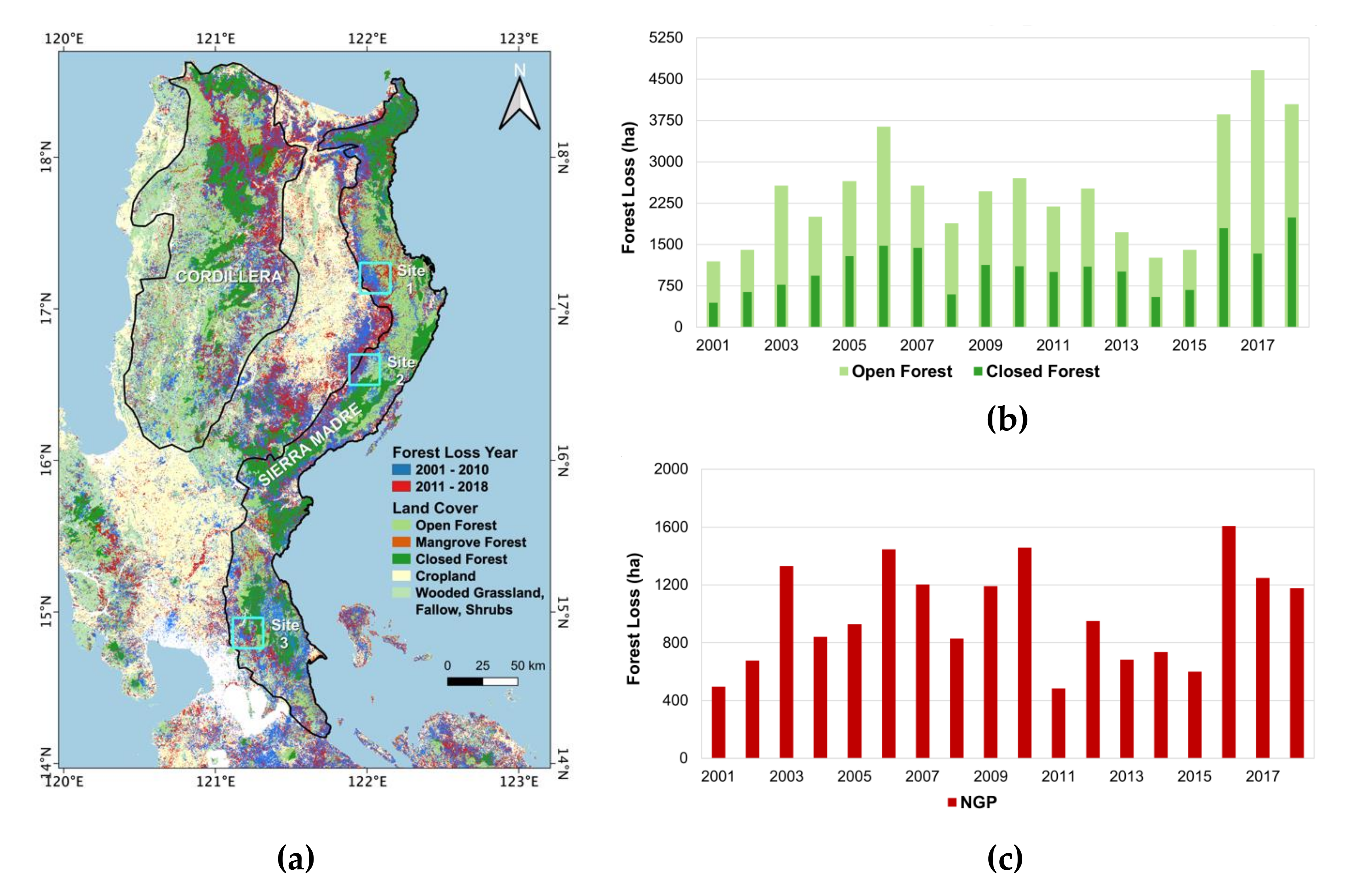
3.1. Estimates of Forest Loss from Landsat

A color-coded map of the land cover of Luzon indicating the general locations of open and closed forests, cropland, mangroves, grassland, and shrubs in 2010, as reported by NAMRIA [27], is presented in Figure 3a. The classification map provides the means to gain insights into the forest cover condition in areas considered as open and closed forest areas. Figure 3a shows a much-depleted closed forest and a relatively more extensive open forest. In the Sierra Madre forest, the closed forest cover is confined mainly in the northern and southern portions. In the Cordillera mountains, the closed forest is not as extensive and is located primarily in the north and central regions. There are also patches of closed forest in the Zambales mountains.
A large fraction of the vegetation cover shown in Figure 3a is areas of forest losses, the sizes of which are displayed at eight times the actual size for improved visibility. The data provided by Hansen et al. [14] indicate vast areas of forest losses in the Sierra Madre forest during the 2001 to 2010 period, while losses in the Cordillera forest were dominant during the 2011 to 2018 period. Interestingly, in some places, the data points of losses are scattered in different places, while some are clustered and adjacent to each other. This implies that there are deforestation activities that are done by low budget operators or farmers with relatively small-scale activities while, at the same time, there are large-scale operators that concentrate their activities in specific sections of the forest. A key concern is that some of the forest loss regions are located inside the closed forest and even in protected areas. As noted below, losses are also found even in areas where NGP sites are located. Due to the reported underestimation in the Hansen product [26], the loss reported in this study is the minimum possible, and the actual loss may even be more serious.
To better assess the magnitude of deforestation and reforestation activities, charts of yearly forest loss in Luzon for both closed (dark green) and open (light green) forests are presented in Figure 3b, using all data from 2001 to 2018. The charts depict similar interannual variations of open and closed forest, indicating a positive trend during the 2001 to 2006 period followed by a decline to a relatively low value in 2008. There was a modest increase in losses in 2009 and 2010, but this was followed by a decreasing trend reaching a record low in 2014 at 553 ha in the closed forest and 1246 ha in the open forest. It is almost as low in 2015, with 677 ha of loss in the closed forest and 1403 ha in the open forest. This is interesting because the decline occurred concurrently with the NGP project initiation in 2011, indicating support to the project and public awareness towards the crucial need for reforestation. However, during the last year of the first phase of the NGP in 2016, the loss area increased suddenly to a relatively high level at 1795 ha for the closed forest and 3862 ha for the open forest and was even higher in 2017 and in 2018. Such an increase in the loss of tree cover during the 2016 to 2018 period is discouraging because it occurred at the end of the first phase and the beginning of the second phase of the national greening program. Quantitatively, it is also important to note that the rate of losses is higher for the closed forest (i.e., 893 ha per year) than for the open forest (i.e., 388 ha per year). This is again a big concern because the much-valued closed forest that is closely connected to the rich biodiversity of the region is being reduced more indiscriminately than the open forest. For completeness, a similar chart is presented in Figure 3c but only in NGP sites. It appears that the unexpected phenomenon depicted in Figure 3b has also been occurring within the NGP sites. These results are disturbing since the goals of a very visible program like NGP that is intended to do reforestation were being negated concurrently by deforestation activities that are likely illegal and executed by unscrupulous entrepreneurs and other entities.

3.2. Regional and Large Scale Assessments of Greening

The availability of continuous coverage of satellite NDVI data from MODIS (which is used as a proxy for forest cover, as discussed previously) provides the opportunity to study regional and large-scale forestry changes in the country. 
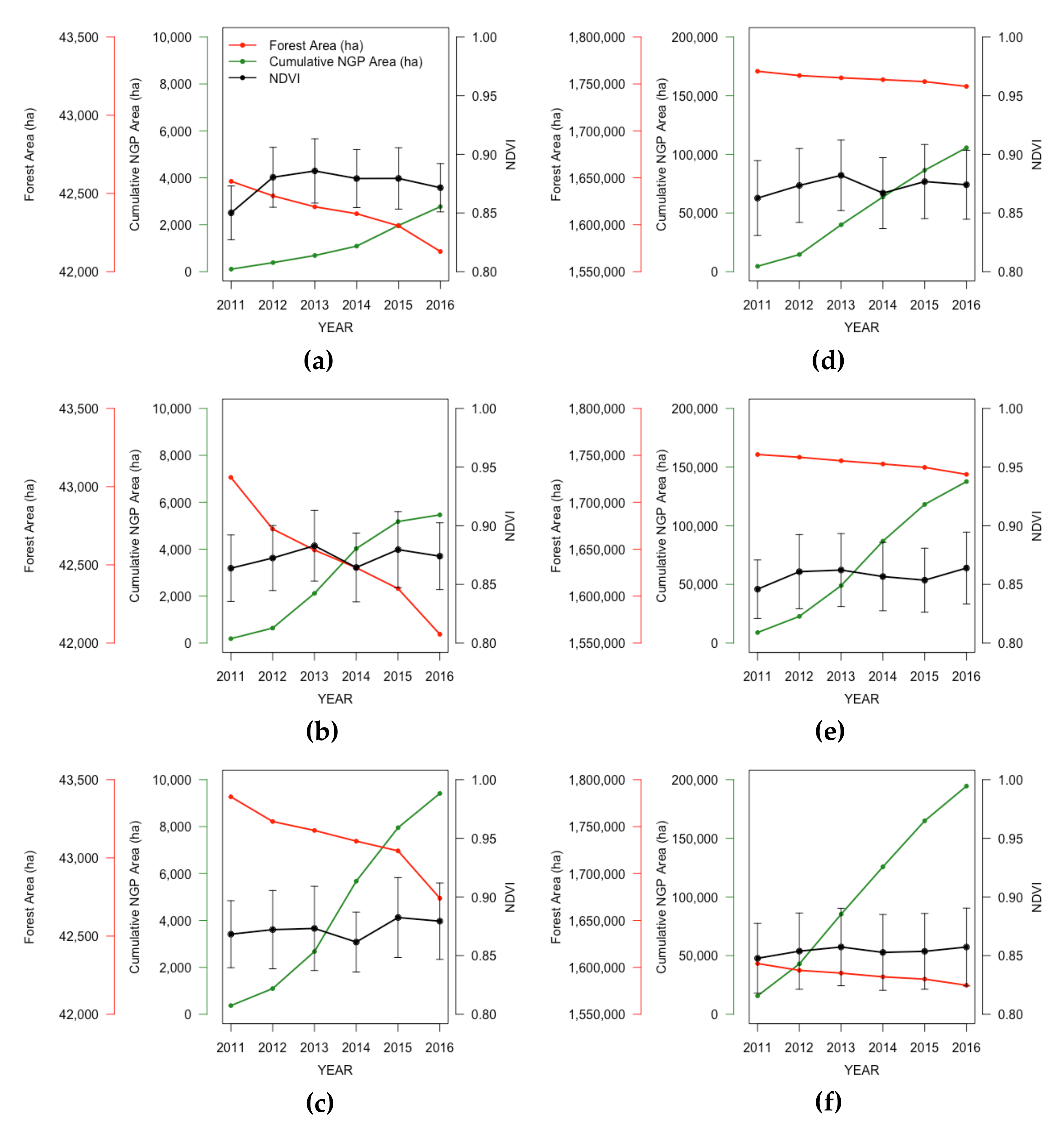
Figure 4a–c show estimates of NDVI yearly averages (in black) as well as reductions in forest area annually (in red) as derived from Hansen’s forest loss data and cumulative forest gain (in green) if the NGP areas are assumed to be wholly reforested in study sites 1, 2 and 3 for the period from 2011 to 2016.
The NDVI plot in site 1 (Figure 4a) shows a slight increase from 2011 to 2013 but is followed by a slight decrease after that, suggesting very minimal or no gain in forest cover. The forested area is also shown to be initially 42,577 ha in 2011 but was reduced to 42,128 ha in 2016, resulting in a net loss of 449 ha, using the loss data of Hansen et al. [14]. On the other hand, if the NGP sites were planted completely by trees during the period, there would have been a gain of about 2770 ha. Overall, there should have been a net gain of about 2300 ha or a 5.4% increase. However, the NDVI data do not show a significant trend.
In Site 2, the NDVI plot in Figure 4b also shows no significant change during the 2011 to 2016 period. Meanwhile, forest cover in the region changed from about 43,059 ha to 42,056 ha, equivalent to a net loss of 1003 ha. On the other hand, the area of NGP sites increased by about 5464 ha during the same period for a net gain of 4461 ha or 10.4%.
In Site 3, there is again no significant change in NDVI during the 2011 to 2016 period, as indicated in Figure 4c. The forest cover changed from 43,390 ha to 42,741 ha, or a net loss of 649 ha. Concurrently, there was an increase in the areal size of NGP sites of 9415 ha. The expected net gain is 8766 ha or 20.2%.
If the NGP sites were entirely planted by trees as assumed in the analysis above, the NDVI data should have shown a significant increase in all sites, but this assumption is likely too optimistic since reports have shown otherwise [35]. However, it is apparent that even if the NGP was correctly implemented, the percentage change in forest cover, as indicated in the study areas, is about 20% or less. Since these results may not represent what is typical for the entire country, a similar analysis was done to the whole of Sierra Madre forest, the Cordillera forest, and the rest of Luzon Island. The results are presented in Figure 4d–f. The yearly changes in NDVI show a slight increase from 2011 to 2012, but became relatively stable after that. Quantitatively, using the Hansen et al. [14] data, the Sierra Madre forest cover shows a decrease from 1,764,000 ha to 1,747,000 ha, for a net loss of 17,000 ha. Meanwhile, a 100% implementation of reforestation in the NGP sites would cause an increase of 105,631 ha, resulting in a net gain of 88,631 ha. On the other hand, the forest cover in Cordillera forest went down from 1,751,000 ha to 1,730,000 ha, for a net loss of 21,000 ha, while the NGP project has a potential gain of 13,000 ha forest cover. For the rest of Luzon, the forest cover went down from 1,604,000 to 1,581,000 ha, for a loss of 23,000 ha, while the NGP project could provide a gain of 195,000 ha and an overall net gain of 172,000 ha. These results are not reflected in the trend of NDVI values presented in Figure 4e,f.
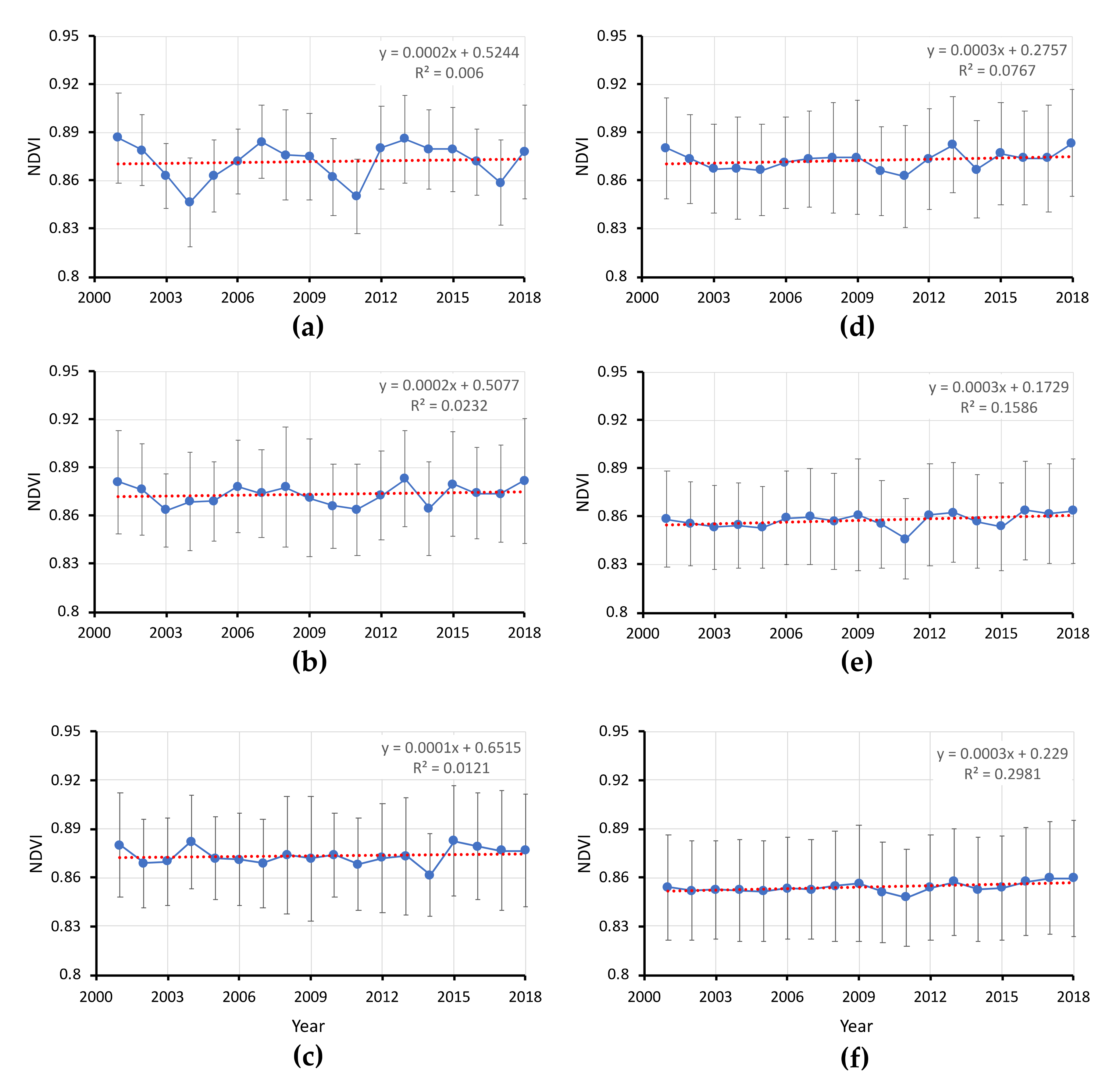
To better evaluate how the forest cover has changed for a more extended period, MODIS/NDVI data from April 2000 to April 2018 was used again as a proxy for forest cover, and results are presented in Figure 5. It is apparent that in the study sites 1, 2, and 3, there is significant interannual variability but, overall, trends are negligible at 0.002 per decade for sites 1 and 2, and 0.001 per decade for site 3. It is also interesting that there is a dip in 2010 before the NGP started and in 2011 during the onset of the NGP period. This means that if only data from 2010 to 2018 are considered, there would be a significant positive trend and it is only through the use of a longer data set that more reliable information about the actual trend can be derived.
The interannual variability and trend are also evaluated at a much larger scale using data from the entire Sierra Madre forest, Cordillera, and the rest of Luzon. The results are presented in Figure 5d–f, respectively. This time, the trends are slightly more positive but still negligible at 0.003 for the three regions. Interestingly, there is an even more persistent dip in 2010 and 2011. The results from the larger scale areas are consistent with those from the three study areas in the Sierra Madre forest.
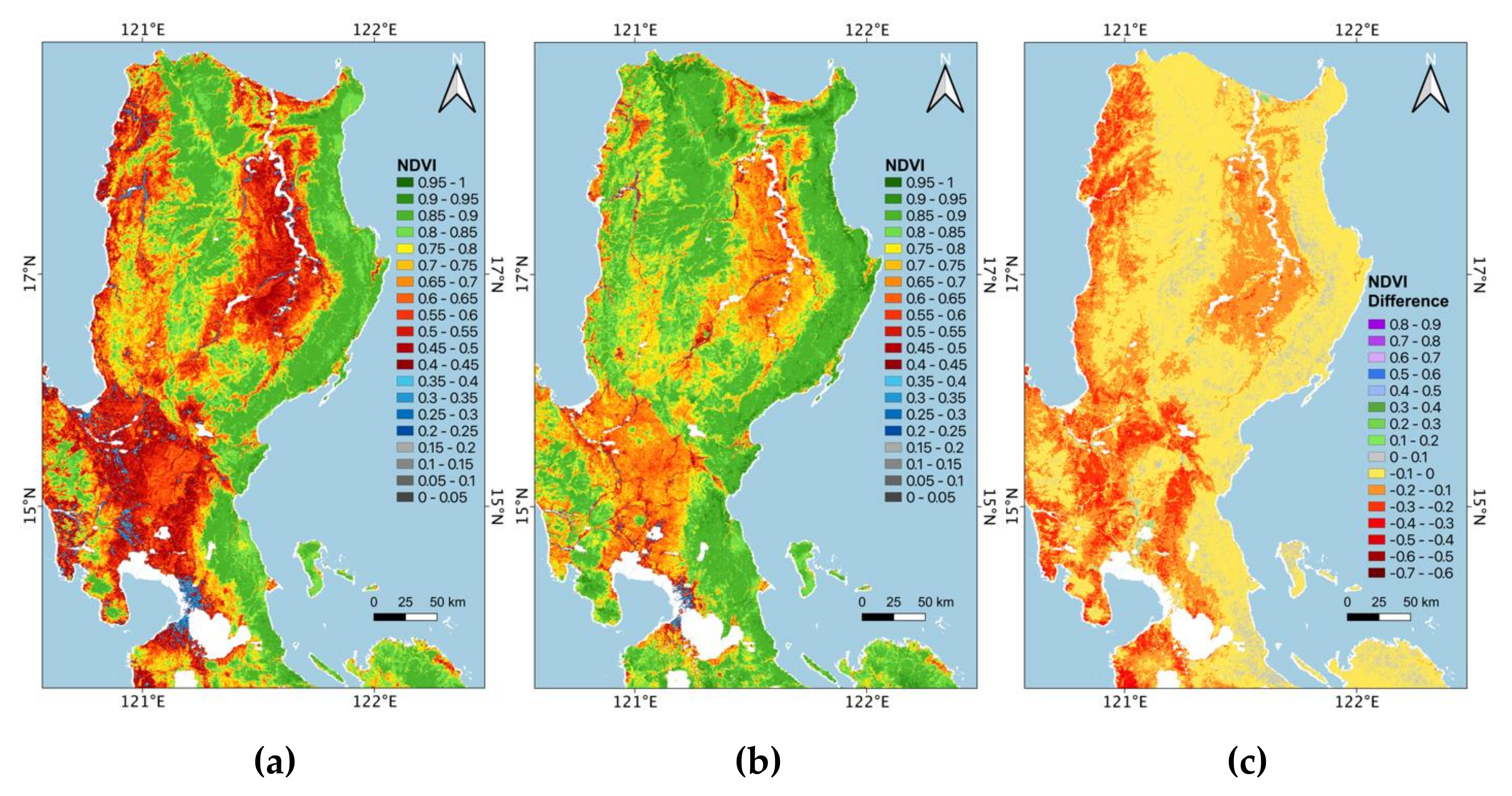
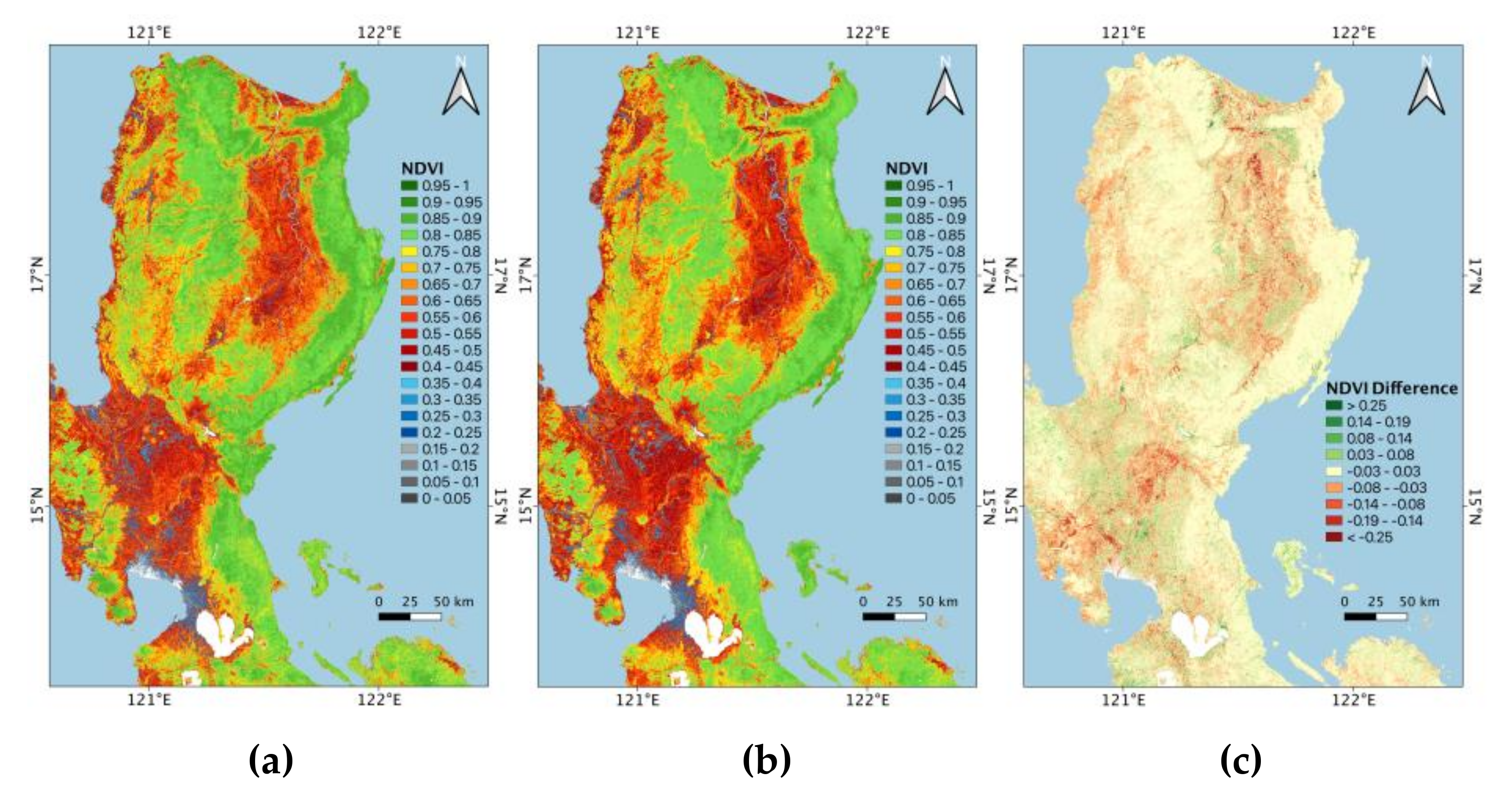
The impact of the NGP is further assessed by looking at the changes in NDVI values before and after the first phase of the NGP. Figure 6a shows the composite NDVI maps from 2008 to 2010, representing the state of the forest cover in Luzon just before the NGP started, while Figure 6b shows the composite values for the period 2017–2019, representing the state of the forest cover after the first phase of the NGP. Visual inspection of the two images indicates a remarkably similar distribution of NDVI values. The changes in NDVI values from the earlier period to the later period are represented by the difference map shown in Figure 6c. The difference map indicates no change (yellow) in the generally forested areas of Sierra Madre, Cordillera, and Zambales forest. This is consistent with the results discussed previously. Some relatively minor changes are apparent both in the middle of the forest and at the edges. The more significant changes are shown to occur in the agricultural and grassland regions, but the changes are almost an even distribution of positive and negative changes. Overall, the maps indicate minimal improvement in the forest cover during the two periods.

3.3. Case Studies in Sierra Madre Forest Using Landsat

To gain insights into the forest cover changes before, during, and after phase 1 of the NGP program, the three study sites in the Sierra Madre forest are analyzed in greater detail. As indicated earlier, the variability and trends in these study sites are similar to those observed from the Sierra Madre and Cordillera forest and the rest of Luzon. In this section, classified vegetation cover from Landsat before, during, and after the first phase of the NGP program in the three sites are evaluated. Landsat data from 2008 to 2010 are used to represent the forest cover before the NGP period, while Landsat data from the 2014 to 2016 period are used to represent the forest cover during the first phase of the NGP period. As indicated earlier, data from 2011 to 2013 are not used because it is an early period of the program when changes due to NGP are only moderate. In addition, Landsat data during the 2017 to 2019 period are used to represent the post-NGP period.
The Landsat images are classified into closed forest, open forest, sparse vegetation, and non-vegetation using the technique described earlier. For each study site, a set of classified images has been generated for the three different periods, and it is apparent that transformations are going on, as part of one class is transformed into another class. Tracking down such conversions is complicated but can be simplified through the use of the Sankey Diagram, as discussed earlier. In this study, the diagram is divided into three columns representing the pre-NGP, NGP, and post-NGP periods. In each column, color-coded representation of the area of each class is presented. From one column to the next, the diagram shows how the area for each class changes in magnitude as part of the area is converted to the other classes.
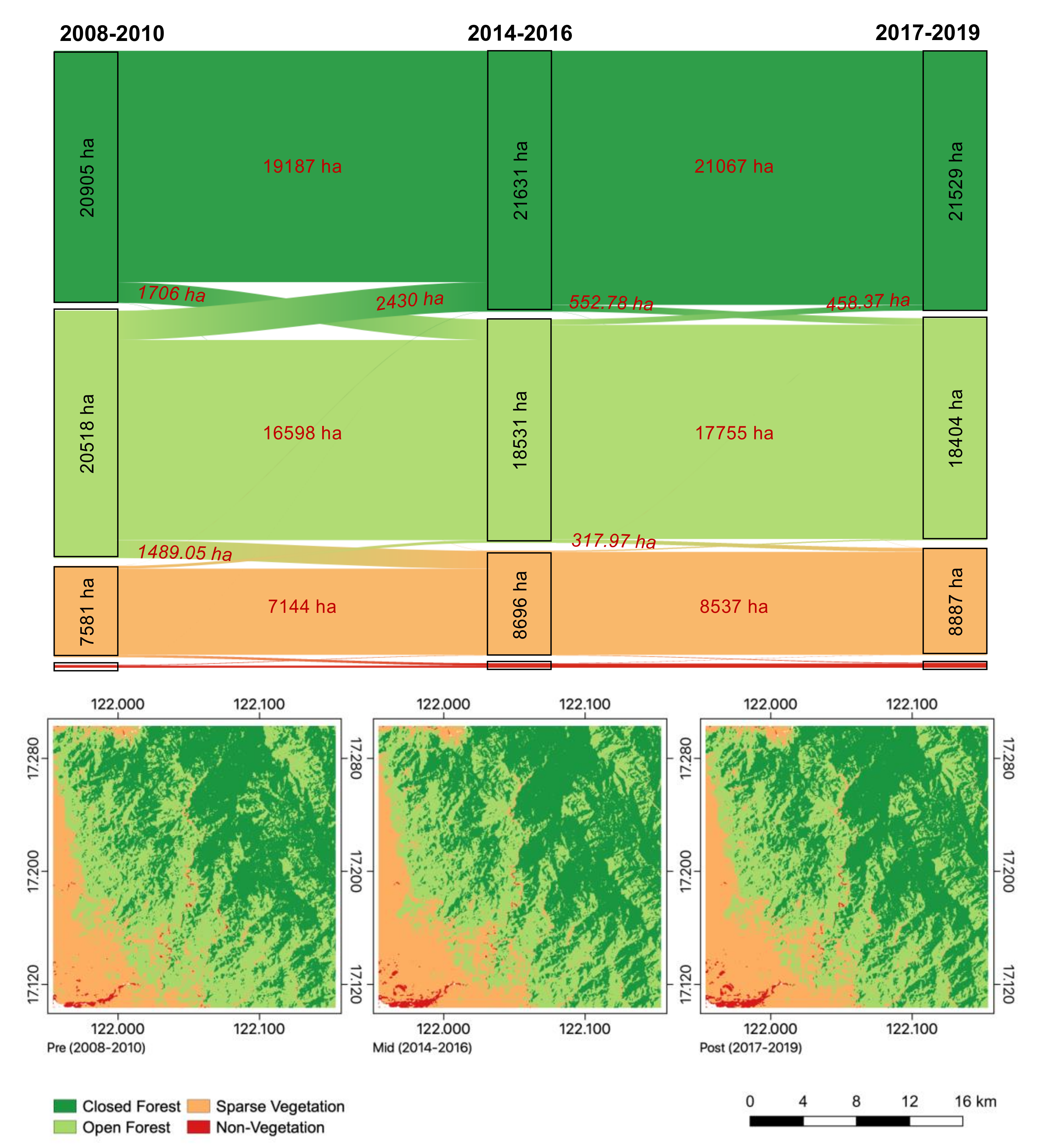
The Sankey Diagram and the associated set of classified images for Site 1 are presented in Figure 7. The classes used in the diagram are closed forest (dark green), open forest (light green), sparse vegetation (orange), and non-vegetation (red). During the pre-NGP period, there is 20,905 ha of closed forest, 20,518 ha of open forest, and 7581 ha of sparse vegetation. During the NGP period, there were significant redistributions in the extent with 1706 ha of closed forest converted to open forest, while 2430 ha of open forest was converted to closed forest. Meanwhile, 1489 ha of open forest was converted to sparse vegetation. The result is that after the end of phase 1 of the NGP, closed forest area increased to 21,631 ha, for a net gain of 726 ha, while open forest decreased in area to 18,531 ha, for a net loss of 1987 ha, and sparse vegetation increased to 8696 ha, for a net gain of 1115 ha. It is encouraging that there is a net gain in closed forest of 624 ha, but open forest suffered a loss of 2114 ha, causing a 3.6% decrease in forest cover. Concurrently, sparse vegetation gained 1309 ha, while the change in non-vegetation is shown to be insignificant. The set of maps in Figure 7 also provides a visual illustration of the spatial distribution of the various classes and the actual redistribution of the areas, as indicated by the Sankey Diagram. It is apparent that in Site 1, there was no improvement in the forest cover during NGP, and results show that there was even a decline.
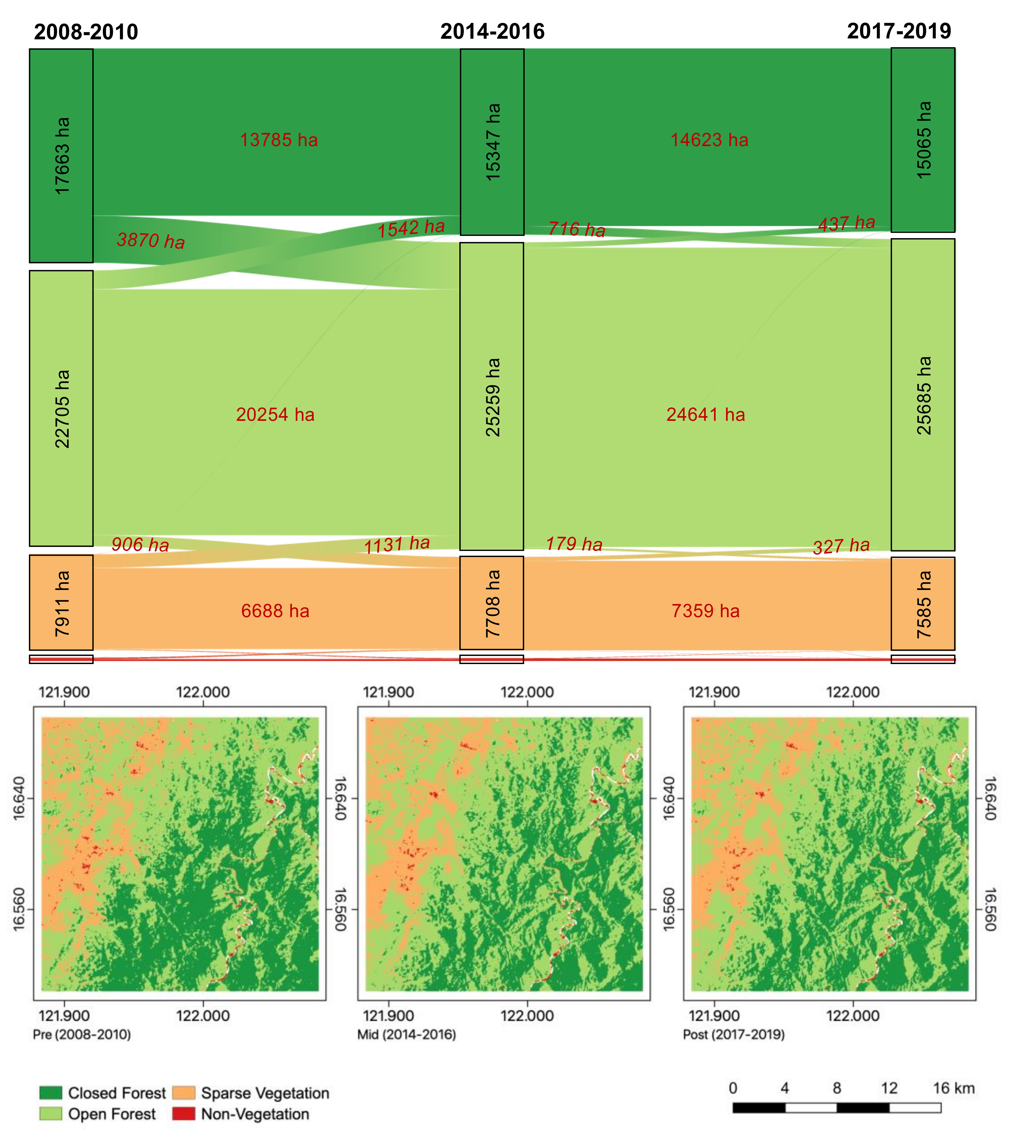
A similar analysis was performed for Site 2, and the Sankey Diagram, together with the corresponding set of classified Landsat images, are presented in Figure 8. The classified Landsat images show an apparent decline in the closed forest cover but an increase in open forest cover. The Sankey diagram shows that before NGP, the extent of the closed forest was 17,663 ha, that of the open forest was 22,705 ha, while that of sparse vegetation was 7911 ha. During NGP, the extent of closed forest cover was reduced to 15,347 ha, mainly because 3870 ha of closed forest became open forest while only 1542 ha of open forest became closed forest. After phase 1 of the NGP, the extent of the closed forest became 15,065 ha. On the other hand, the size of the open forest increased to 25,259 ha during NGP and increased further to 25,685 ha after the first phase of the NGP. Part of the increase is actually due to the reduction in Sparse Vegetation from 7911 ha to 7585 ha, which is likely on account of the NGP. The net loss of closed forest is 2598 ha while the net gain of the open forest is 2980 ha, leading to a net increase of 382 ha or a 0.9% increase in forest cover. In Site 2, there is an overall insignificant increase in forest cover, but the significant decline in the closed forest is disturbing.
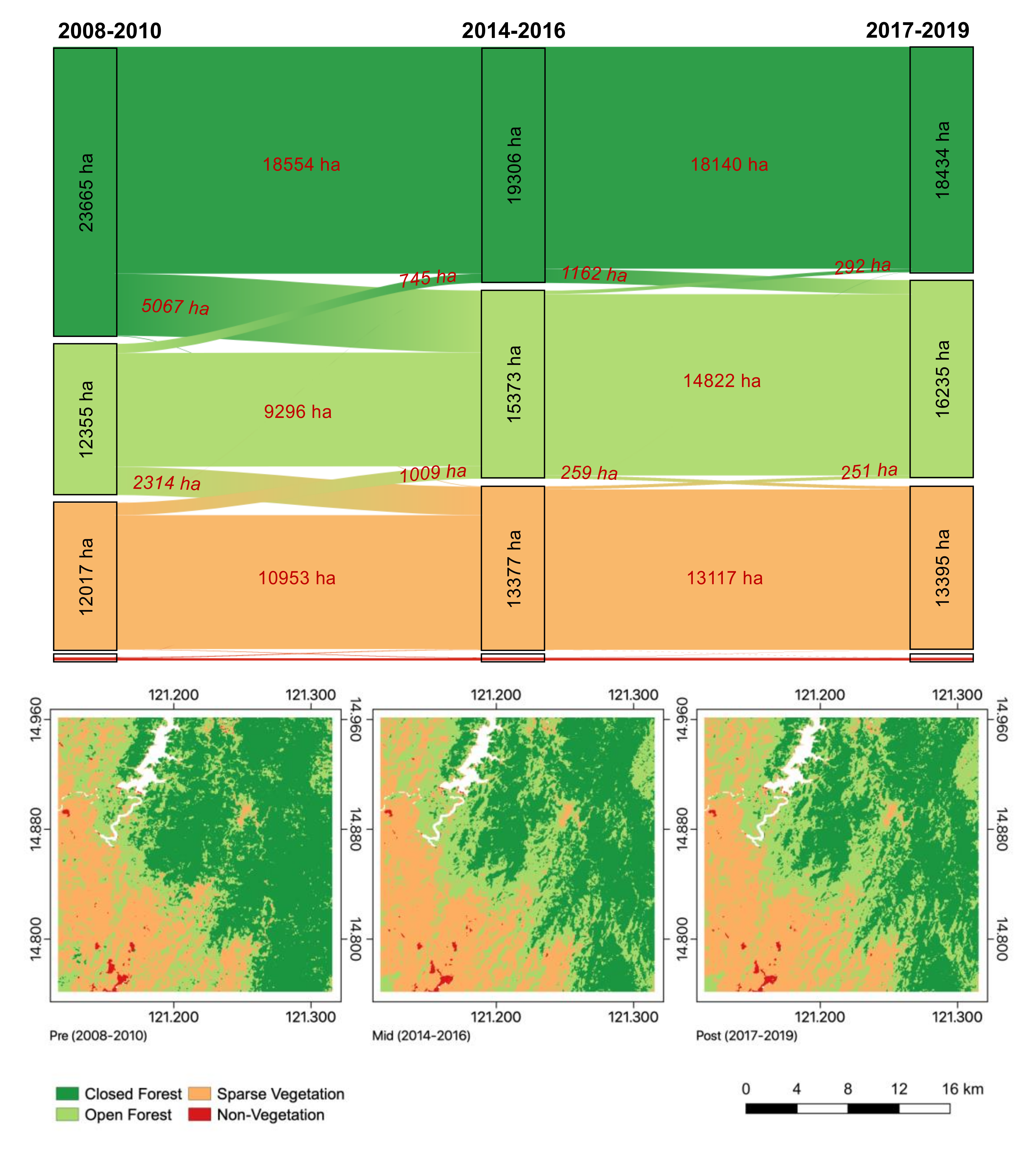
The procedure was repeated in Site 3, and the Sankey Diagram and the set of classified Landsat images, as presented in Figure 9, show results similar to those of Site 2. During the pre-NGP period, the extent of the closed forest was 23,665 ha, that of the open forest was 12,355 ha, while that of sparse vegetation was 12,017 ha. There was significant redistribution in the extents during the NGP period, with 5067 ha of closed forest converted to open forest while only 745 ha of open forest became closed forest. Meanwhile, 2314 ha of open forest was converted to sparse vegetation while only 1009 ha of sparse vegetation was converted to open forest. The result is that, after the end of phase 1 of the NGP, closed forest area was reduced to 18,434 ha, open forest increased in area to 16,235 ha, while sparse vegetation increased to 13,395. Overall, in Site 3, there was a reduction in the extent of closed forest by 5231 ha while, concurrently, there was an increase in the extent of open forest by 3880 ha. The net loss is 1351 ha or a 3.8% decline in the forest cover, which is significant, but more importantly, there was a considerable and damaging loss in the extent of closed forest cover.

3.4. Monitoring NGP Sites Using VHR Images

To gain additional insight into the observed changes, a sequence of very high-resolution (VHR) images is used to assess qualitatively, but in good spatial detail, how the vegetation cover gets transformed from one period to another. The VHR images were accessed through Google Earth Pro. Enhancements were applied to make the images uniformly calibrated. The resolution of the RGB images (at about 1 to 3 m) is good enough to discriminate the barren areas and the different vegetation cover types. 
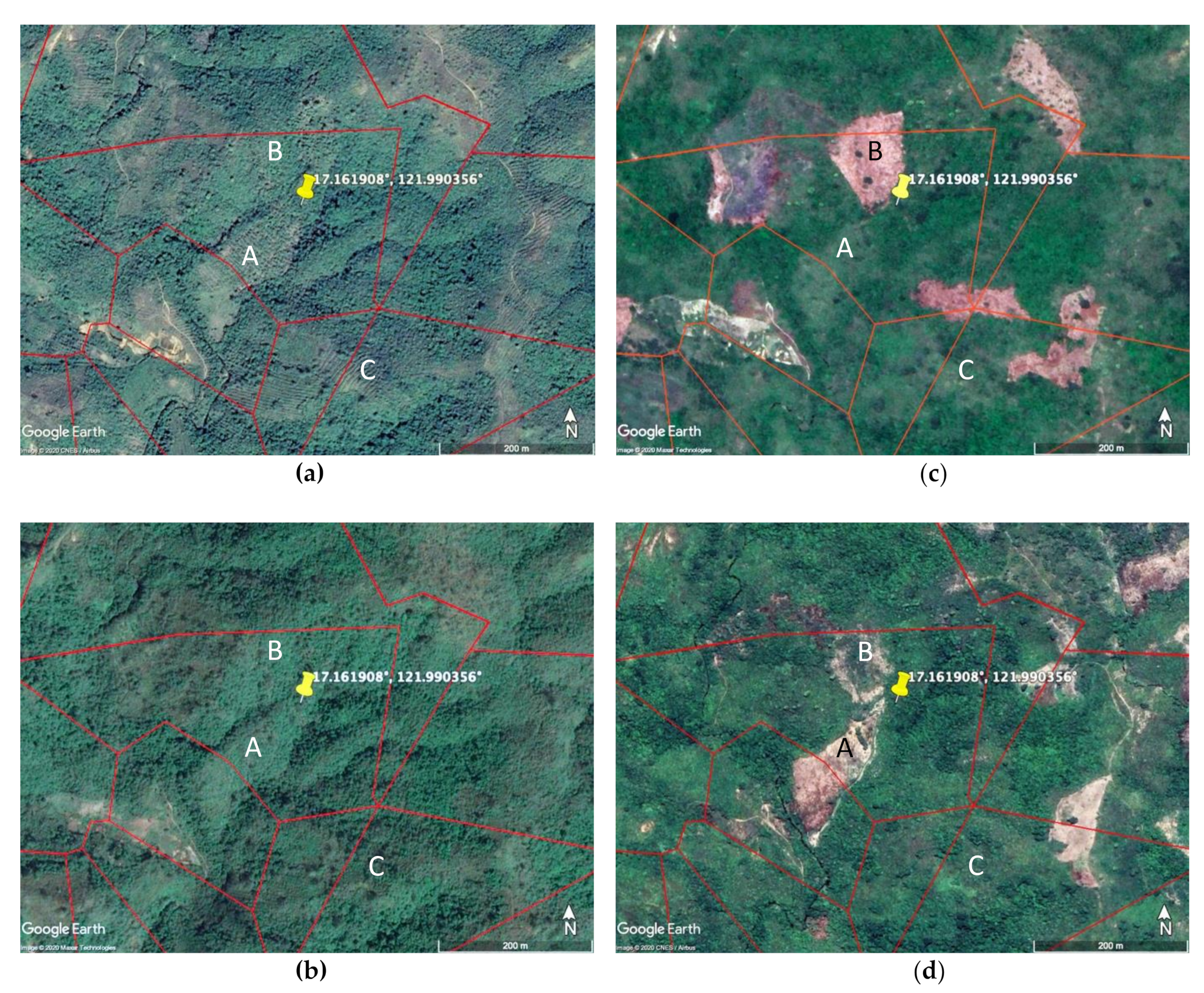
Figure 10 presents a sequence of images taken on 2 March 2014 (Figure 10a), 15 January 2016 (Figure 10b), 5 April 2016 (Figure 10c), and 11 July 2019 (Figure 10d) for several NGP sites within Site 1. The images indicate that the trend in vegetation in the NGP areas, identified by the red contour lines, is not always positive. During the NGP years, some areas became greener while other areas lost their forest cover. For example, an NGP area with label A is shown to have a moderate increase in vegetation cover from 2 March 2014 through 5 April 2016, but became almost barren on 11 July 2019. Similarly, the vegetation cover in B was slightly enhanced on 15 January 2016, but became barren only three months later on 5 April 2016, and recovered slightly on 11 July 2019. Several other areas also became barren on 5 April 2016 at the end of Phase 1 of the NGP, which is consistent with the forest loss shown earlier in Figure 3. Meanwhile, several vegetation patches similar to area B were lost on 5 April 2016, as shown in Figure 10c. The area labeled C is shown to have similar vegetation cover throughout the period, but surrounding areas became barren on 5 April 2016, as indicated in Figure 10c. Burn scars are evident in some of the patches of barren land. Overall, the images from March 2014 to April 2016 show a general decline in the vegetation cover during NGP, but a recovery was observed (except in A) in July 2019 that is likely because of ENGP, but it is not much of an improvement compared to 2014.
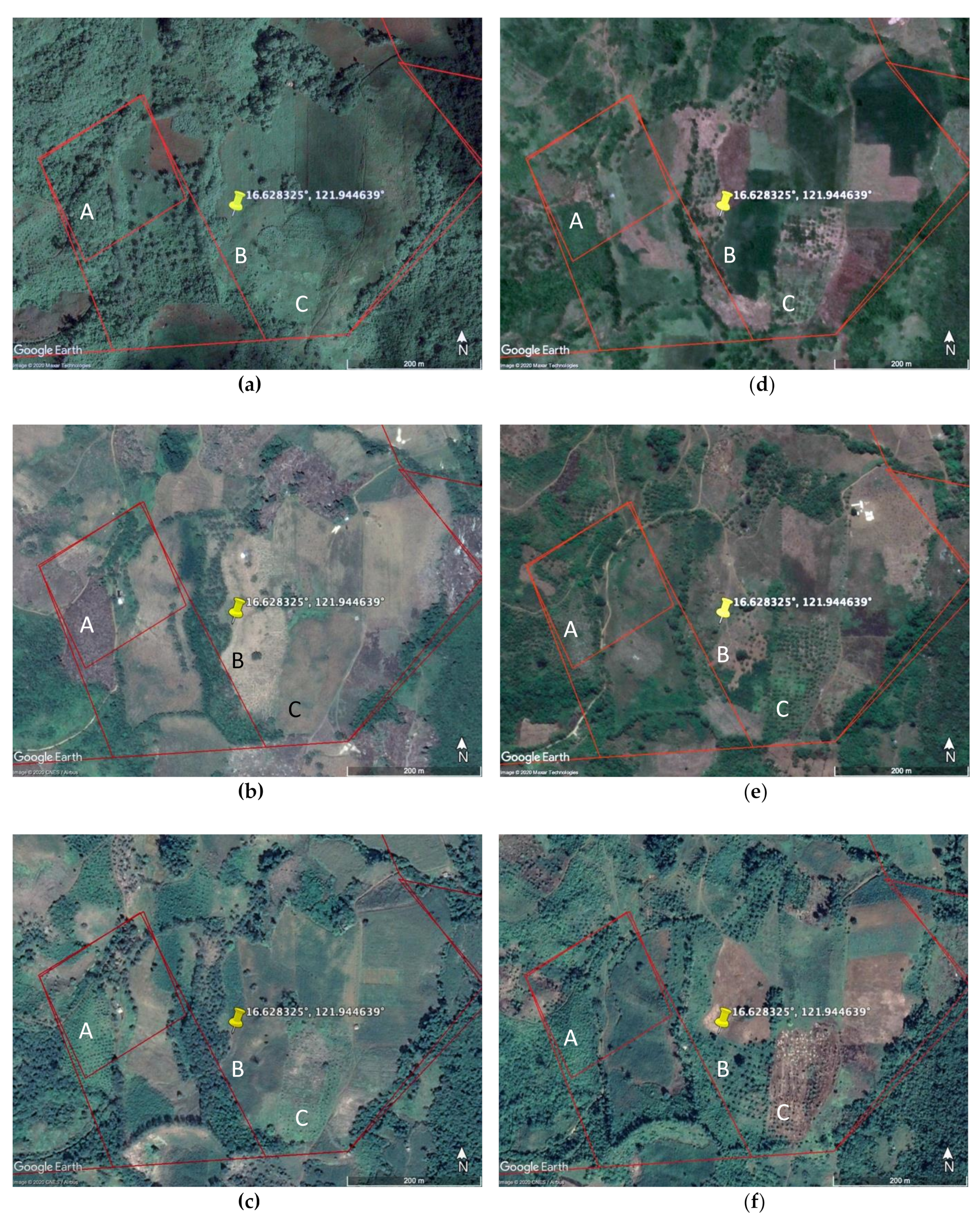
The set of VHR images shown in Figure 11, representing selected NGP areas within Site 2, illustrates an even more serious issue. The image in Figure 11a taken on 30 January 2010 depicts a relatively robust vegetation condition before the start of the NGP, but by 13 May 2014, which is during the NGP, much of the vegetation is gone, as shown in Figure 11b. This is quite contrary to what has been expected. In particular, the areas labeled A, B, and C, and other areas, became practically barren from 2010 to 2014. Some improvements are apparent by 23 February 2015 (Figure 11c), and more significantly by 23 March 2017 (Figure 11d), especially for A and B. However, the gains in A and B, as well as in other areas, were lost again only a year later on 18 June 2018, as depicted in Figure 11e. At a closer look, it is evident that some areas surrounding the NGP sites are also used for farming. A restoration was again implemented, as observed on 17 February 2019, and shown in Figure 11f. It appears that new trees are being planted in A and B, but although there is an improvement from 2018 to 2019 in A, a similar improvement is not apparent in B. The reforestation strategy for NGP does not appear consistent, and for NGP to succeed, more effort should be spent on preventing losses during the program.
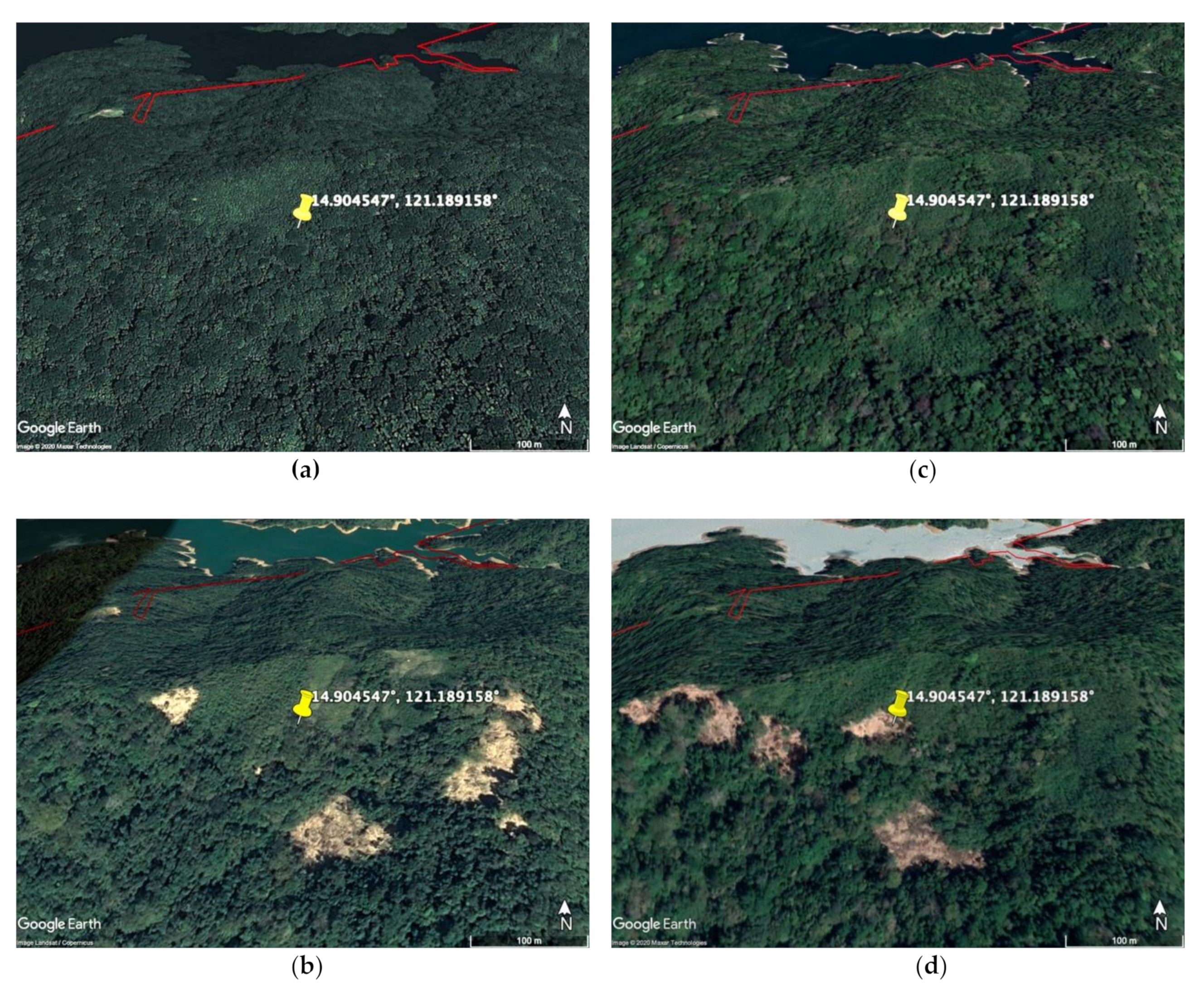
While the previous two examples are located in more accessible areas, Figure 12 shows a sequence of images of an upland area where both open and closed forest canopies exist. In particular, the images are taken on 2 November 2012 (Figure 12a), 20 March 2015 (Figure 12b), 16 March 2018 (Figure 12c), and 26 March 2019 (Figure 12d) of an NGP area within Site 3. Figure 12a depicts a closed canopy cover at the start of the NGP, but patches of denuded forest started to emerge in the middle of the NGP, as shown in Figure 12b,c, which shows that these areas appear to have recovered in 2018 but only to be lost again and even expanded a year later, as shown in Figure 12d.
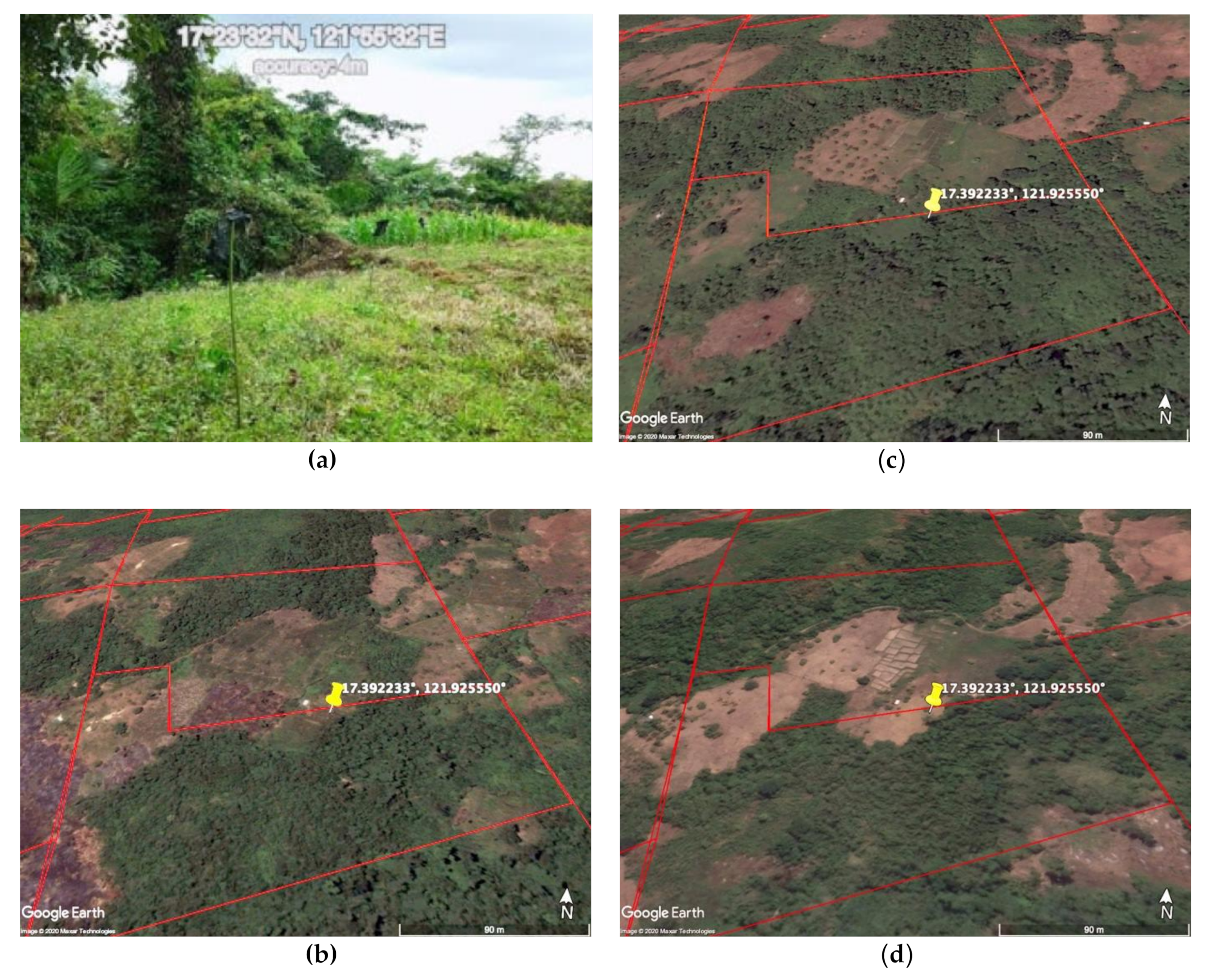
One of the overarching issues of interest is whether there is a plan to ensure that the seedlings have a good chance to survive after planting. To illustrate what is going on in the ground, Figure 13 and Figure 14 show VHR images from two NGP areas in Sierra Madre and Cordillera, respectively. In addition to the VHR images, geotagged photos taken by DENR of the actual plantation areas are also shown. Figure 13a is a photo that shows a densely vegetated area covering the left side and an open vegetation area on the right side with a single identifiable plant or seedling in the middle that may be accompanied by smaller plants. A series of VHR images covering the site where the geotagged photo was taken is shown in Figure 13b–d. Figure 13a, which was taken on 15 April 2012, indicates some newly planted areas that appear to have grown by 2015, as shown in Figure 13c. However, it became barren again in 2018, as depicted in Figure 13d. The photo in Figure 13a demonstrates the vulnerability of plants in open vegetation areas and the difficulty of tree seedlings to survive unless they are under proper care and attention during early stages that require the combined use of water and fertilizer, as well as pest and disease control. The corresponding VHR satellite images seem to support this finding.
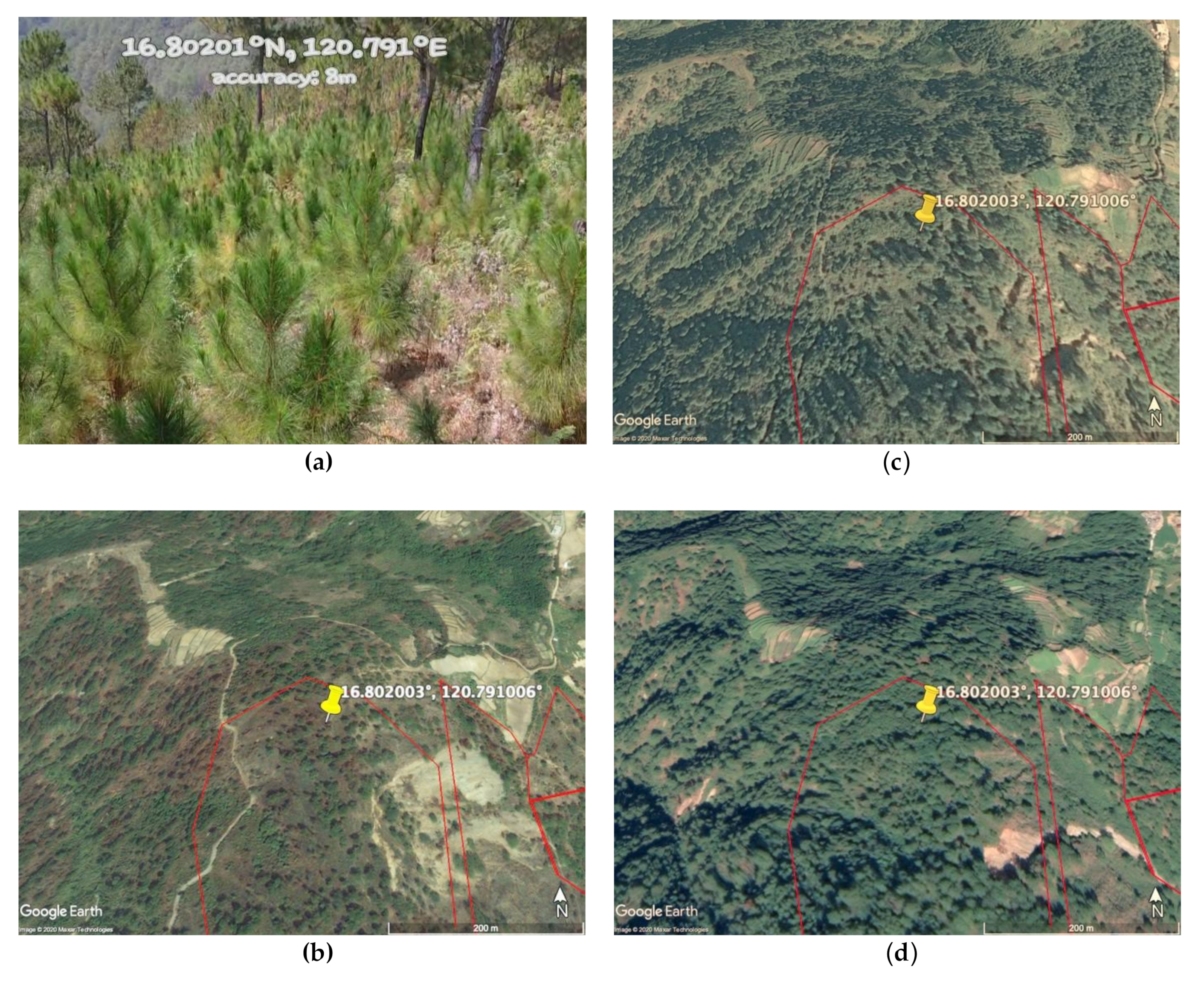
It is important to indicate that not all NGP sites have problems similar to those indicated previously. An example of a case where NGP was properly implemented is shown in Figure 14. The geotagged photo in Figure 14a shows relatively grown-up seedlings of pine trees in the NGP area as of 10 March 2014. A VHR image of the general location as of 22 April 2010 and shown in Figure 14b illustrates an almost barren area in the region. On 6 January 2014, about three months before the photo was taken, it is apparent that the area has much more robust vegetation, as indicated in Figure 14c. The vegetation in the entire region has also improved significantly. In this case, NGP succeeded in transforming a degraded area into a much more desirable vegetated and forested area.

4. Conclusions

The National Greening Program (NGP) that started in 2011 is an ambitious but a much-needed program that involves large scale restoration of forest cover in the country with the planting of more than a billion seedlings of trees. The goals of the NGP have strong scientific merit considering that the forest cover in the country has been drastically reduced to a highly deplorable state. The program has also helped the impoverished farmers and residents in the region do the planting of seedlings consisting of forest trees like Narra, Lauan, and Mahogany, and trees that provide immediate economic benefits like fruit trees, cacao, coffee, rubber, and bamboo. The reported success of the program has led to the extension of the activities to 2028.
However, the results of this study indicate that such a report is premature and may be difficult to justify. In particular, the results of this study suggest that despite the massive number of seedlings reported to have been planted, the state of the forest cover, at least in the greater Luzon region, does not show significant improvement on a large as well as regional scale. Analysis of Landsat data reveals significant losses in both open and closed forest cover during the same period when NGP was ongoing. This is alarming, especially since the extent of losses even increased significantly towards the end of phase 1 of the NGP program.
Satellite data indicate that the implementation of the NGP has not been done as effectively as desired. Time-series studies of forest cover in three study areas and the entire Sierra Madre, Cordillera, and Northern Luzon area reveal that there has not been a monotonical increase in vegetation or forest cover as expected from the highly touted NGP program. The results of trend analysis indicate practically no trend from the start of the NGP period to 2018. The use of MODIS data for more comprehensive coverage and longer record length also yielded a lack of increase in vegetation and forest cover.
A case study in the Sierra Madre forest using classified Landsat data and Sankey Diagrams shows modest but significant changes in the closed and open forest but not necessarily in the same direction. In Site 1, there was a slight increase in closed forest cover of 3% while the open forest suffered a loss of about 10%. In Site 2, there was a reversal in that the closed forest cover declined by about 9% while the open forest cover increased by about 13%. In Site 3, closed forest cover declined by 22% while the open forest increased by 31%. The net loss of open forest in Site 1 of about 1305 ha is acceptable, especially since there is a gain of 625 ha in closed forest. However, although the results in Site 2 and 3 show net increases in forest cover, the significant losses of 9% for Site 2 and 22% in site 3 in the extent of closed forest are disappointing. High-resolution data were used to confirm unambiguously that deforestation was going on while NGP was being implemented. Many seedlings were observed to be planted in open areas where it is unlikely that the plants get the kind of attention and care needed to survive.
The use of satellite data in this study is confined to optical sensors only, which are known to be vulnerable to cloud cover. This is generally acceptable because the forest cover does not change much over a relatively short period and clouds are dynamic with cloud-covered areas eventually becoming cloud-free over a reasonable period. For near real-time monitoring, the use of microwave data such as those from SAR, radar altimeter, and passive microwave radiometers would be more useful. For improved resolution in a limited area, the use of aircraft data and drones carrying similar sensors would be desirable. Detailed information about the forest cover, including canopy, tree type, and tree height, can be obtained through other types of sensors such as SAR, radar altimeter, and Lidar.
As the second phase of the NGP is being implemented, the activity must be better monitored to ensure that some of the key goals are achieved. In this regard, regular reporting of the project’s success and shortcomings should be made available near real-time and more accurately assessed through the combined use of in situ and satellite data. For an effective restoration of the forest, the NGP should also be accompanied by a conscious effort to reduce, if not eliminate, deforestation. The preservation of existing forests and especially old-growth forest is more desired because of their critical role in preserving the biodiversity and ecology of the region.

Author Contributions

Conceptualization, G.J.P., P.S.O., J.C.C., and L.V.A.; methodology, G.J.P., J.C.C., P.S.O., L.V.A. and H.C.M.; software, G.J.P., J.C.C., H.C.M.; validation, G.J.P., J.C.C., H.C.M., P.S.O., and L.V.A.; formal analysis, G.J.P., J.C.C., P.S.O., L.V.A., and H.C.M.; investigation, G.J.P., J.C.C., P.S.O., L.V.A., and H.C.M.; resources, P.S.O., G.J.P., J.C.C., and L.V.A.; data curation, G.J.P., J.C.C., and H.C.M.; writing—original draft preparation, G.J.P., J.C.C., and P.S.O.; writing—review and editing, G.J.P., J.C.C., and L.V.A.; visualization, G.J.P., J.C.C., H.C.M., and P.S.O.; supervision, G.J.P., J.C.C., L.V.A., and P.S.O.; project administration, G.J.P., J.C.C., L.V.A., and P.S.O.; funding acquisition, G.J.P., J.C.C., and P.S.O. All authors have read and agreed to the published version of the manuscript.

Funding

This research was partly funded by the Department of Science and Technology (DOST) through the Sustained Support for Local Space Technology and Applications Mastery, Innovation and Advancement (STAMINA4Space) Program: Ground Receiving, Science Product Development and Distribution (GRASPED) Project. GJ Perez received funding support from the Natural Science Research Institute (NSRI) under grant number ESM-15-1-01. JC Comiso received funding support from the DOST Balik Scientist Program to undertake this research.

Acknowledgments

This paper is dedicated to the memory of Perry S. Ong who died unexpectedly while this study, which was primarily conceived and driven by him, was in progress. Dean Perry S Ong of the College of Science, University of the Philippines in Diliman was one of the premier wildlife biologists and conservationists of the Philippines. He steered the national movement for the protection and eventual development of a national roadmap for the conservation of terrestrial and marine ecosystems and, more importantly, he was one of the main movers and supporters of the National Greening Program. With much passion, he insisted on accountability, transparency and proper application of science for the monitoring of the NGP.

Conflicts of Interest

The authors declare no conflict of interest.

References

  1. Heaney, L.; Mittermeier, R.A. The Philippines. In Megadiversity: Earths Biologically Wealthiest Nations; Robles, G.P., Ed.; CMEX: Taipei, Taiwan, 1997; pp. 236–255. [Google Scholar]
  2. Bankoff, G. One Island Too Many: Reappraising the Extent of Deforestation in the Philippines prior to 1946. J. Hist. Geogr. 2007, 33, 314–334. [Google Scholar] [CrossRef]
  3. Catibog-Sinha, C.; Heaney, L.R. Philippine Biodiversity: Principles and Practice; Haribon Foundation for the Conservation of Natural Resources, Inc.: Quezon City, Philippines, 2006. [Google Scholar]
  4. Ong, P.S.; Rosell-Ambal, R.G.; Afuang, L.E. Philippine Biodiversity Conservation Priorities: A Second Iteration of the National Biodiversity Strategy and Action Plan; Department of Environment and Natural Resources, Conservation International, University of the Philippines Center for Integrative and Development Studies, and Foundation for the Philippine Environment: Quezon City, Philippines, 2002. [Google Scholar]
  5. Moya, T.B.; Malayang, B.S. Climate variability and deforestation-reforestation dynamics in the Philippines. Environ. Dev. Sustain. 2004, 6, 261–277. [Google Scholar] [CrossRef]
  6. Araño, R.R.; Persoon, G.A. Action research for community-based resource management and development: The case of the northern Sierra Madre Natural Park conservation project, in Northeastern Philippines. In Research in Tropical Rain Forests: Its Challenges for the Future; Tropenpos International: Wageningen, The Netherlands, 1997; p. 101. [Google Scholar]
  7. Suarez, R.K.; Sajise, P.E. Deforestation, Swidden Agriculture and Philippine Biodiversity. Philipp. Sci. Lett. 2010, 3, 91–99. [Google Scholar]
  8. Apan, A.; Suarez, L.A.; Maraseni, T.; Castillo, A. The rate, extent and spatial predictors of forest loss (2000–2012) in the terrestrial protected areas of the Philippines. Appl. Geogr. 2017, 81, 32–42. [Google Scholar] [CrossRef]
  9. Novick, K.A.; Katul, G.G. The duality of reforestation impacts on surface and air temperature. J. Geophys. Res. Biogeosci. 2020, 125, e2019JG005543. [Google Scholar] [CrossRef]
  10. Department of Environment and Natural Resources–Expanded National Greening Program. Available online: https://www.denr.gov.ph/index.php/priority-programs/national-greening-program (accessed on 31 July 2020).
  11. Fostering Education and Environment for Development, Inc. Enhanced National Greening Program. Available online: https://feed.org.ph/engagement-activities/enhanced-national-greening-program/ (accessed on 5 October 2020).
  12. Wilkie, L.M. Whither the forests of Asia and the Pacific. In The Future of Forests in Asia and the Pacific: Outlook for 2020, Chiang Mai, Thailand, 16–18 October 2007; Leslie, R.N., Ed.; Food and Agriculture Organization of the United Nations, Asia-Pacific Forestry Commission: Washington, DC, USA, 2009; pp. 31–51. [Google Scholar]
  13. Song, X.P.; Hansen, M.C.; Stehman, S.; Potapov, P.V.; Tyukavina, A.; Vermote, E.F. Global land change from 1982 to 2016. Nature 2018, 560, 639–643. [Google Scholar] [CrossRef]
  14. Hansen, M.C.; Potapov, P.V.; Moore, R.; Hancher, M.; Turubanova, S.A.; Tyukavina, A.; Thau, D.; Stehman, S.V.; Goetz, S.J.; Loveland, T.R.; et al. High-resolution global maps of 21st-century forest cover change. Science 2013, 342, 850–853. [Google Scholar] [CrossRef] [Green Version]
  15. Turner, B.L., II; Lambin, E.F.; Reeberg, A. The emergence of land change science for global environmental change and sustainability. Proc. Natl. Acad. Sci. USA 2007, 104, 20666–20671. [Google Scholar] [CrossRef] [Green Version]
  16. Foley, J.A.; DeFries, R.; Asner, G.P.; Barford, C.; Bonan, G.; Carpenter, S.R.; Chapin, F.S.; Coe, M.T.; Daily, G.C.; Gibbs, H.K.; et al. Global consequences of land use. Science 2005, 309, 570–574. [Google Scholar] [CrossRef] [Green Version]
  17. Poulsen, M.K. The Threatened and Near-Threatened Birds of Luzon, Philippines, and the Role of the Sierra Madre Mountains in Their Conservation. Bird Conserv. Int. 1995, 5, 79–115. [Google Scholar] [CrossRef] [Green Version]
  18. Tucker, C.J. Red and photographic infrared linear combinations for monitoring vegetation. Remote Sens. Environ. 1979, 8, 127–150. [Google Scholar] [CrossRef] [Green Version]
  19. Perez, G.J.; Comiso, J.C. Seasonal and Interannual Variability of Philippine Vegetation as Seen from Space. Philipp. J. Sci. 2014, 43, 147–155. [Google Scholar]
  20. Tucker, J.; Sellers, P.J. Satellite remote sensing of primary production. Int. J. Remote Sens. 1986, 7, 1395–1416. [Google Scholar] [CrossRef]
  21. Sexton, J.O.; Song, X.P.; Feng, M.; Noojipady, P.; Anand, A.; Huang, C.; Kim, D.H.; Collins, K.M.; Channan, S.; DiMiceli, C.; et al. Global 30-m resolution continuous fields of tree cover: Landsat-based rescaling of MODIS Vegetation Continuous Fields with lidar-based estimates of error. Int. J. Digit. Earth 2013, 6, 427–448. [Google Scholar] [CrossRef] [Green Version]
  22. Margono, B.A.; Potapov, P.V.; Turubanova, S.; Stolle, F.; Hansen, M.C. Primary forest cover loss in Indonesia over 2000–2012. Nat. Clim. Chang. 2014, 4, 730–735. [Google Scholar] [CrossRef]
  23. Potapov, P.; Hansen, M.C.; Laestadius, L.; Turubanova, S.; Yaroshenko, A.; Thies, C.; Smith, W.; Zhuravleva, I.; Komarova, A.; Minnemeyer, S.; et al. The last frontiers of wilderness: Tracking loss of intact forest landscapes from 2000 to 2013. Sci. Adv. 2017, 3, e1600821. [Google Scholar] [CrossRef] [PubMed] [Green Version]
  24. Yuan, W.; Li, X.; Liang, S.; Cui, X.; Dong, W.; Liu, S.; Xia, J.; Chen, Y.; Liu, D.; Zhu, W. Characterization of locations and extents of afforestation from the Grain for Green Project in China. Remote Sens. Lett. 2014, 5, 221–229. [Google Scholar] [CrossRef]
  25. Jeong, S.J.; Ho, C.H.; Choi, S.D.; Kim, J.; Lee, E.J.; Gim, H.J. Satellite data-based phenological evaluation of the nationwide reforestation of South Korea. PLoS ONE 2013, 8, e58900. [Google Scholar] [CrossRef] [Green Version]
  26. Tropek, R.; Sedláček, O.; Beck, J.; Keil, P.; Musilová6, Z.; Šímová, I.; Storch, D. Comment on “High-resolution global maps of 21st-century forest cover change”. Science 2014, 344, 981. [Google Scholar] [CrossRef] [Green Version]
  27. Manuel, W.V. Land Cover Data in the Philippines. In Proceedings of the 5th UNREDD Regional Lessons Learned Workshop on Monitoring Systems and Reference Levels for REDD+, Hanoi, Vietnam, 20–22 October 2014. [Google Scholar]
  28. Roy, D.P.; Kovalskyy, V.; Zhang, H.K.; Vermote, E.F.; Yan, L.; Kumar, S.S.; Egorov, A. Characterization of Landsat-7 to Landsat-8 reflective wavelength and normalized difference vegetation index continuity. Remote Sens. Environ. 2016, 185, 57–70. [Google Scholar] [CrossRef] [Green Version]
  29. R Core Team. R: A Language and Environment for Statistical Computing. R Foundation for Statistical Computing. Available online: https://www.R-project.org/ (accessed on 27 September 2020).
  30. Hijmans, R.J. Raster: Geographic Data Analysis and Modeling. R Package Version 3.0-12. Available online: https://CRAN.R-project.org/package=raster (accessed on 27 September 2020).
  31. Liaw, A.; Wiener, M. Classification and Regression by randomForest. R News 2002, 2, 18–22. [Google Scholar]
  32. Fortier, J.; Rogan, J.; Woodcock, C.E.; Runfola, D.M. Utilizing temporally invariant calibration sites to classify multiple dates and types of satellite imagery. Photogramm. Eng. Remote Sens. 2011, 77, 181–189. [Google Scholar] [CrossRef]
  33. Song, C.; Woodcock, C.E. Monitoring forest succession with multitemporal Landsat images: Factors of uncertainty. IEEE Trans. Geosci. Remote Sens. 2003, 41, 2557–2567. [Google Scholar] [CrossRef]
  34. Gesmann, M.; de Castillo, D. Using the Google visualisation API with R. R J. 2011, 3, 40–44. [Google Scholar] [CrossRef] [Green Version]
  35. Vista, A.; Cororaton, C.B.; Inocencio, A.B.; Tiongco, M.M.; Manalang, A.B.S. Impact Assessment of the National Greening Program of the DENR: Scoping or Process Evaluation Phase (Economic Component); Discussion Paper Series No. 2016-27; Philippine Institute for Development Studies: Quezon City, Philippines, 2016; p. 84. [Google Scholar]
Figure 1. Satellite image of Northern Luzon showing the percentage of forest cover in the year 2000 as derived from Landsat data [14] and the locations (in red) of the National Greening Program (NGP) activities from 2011 to 2016. The three sites used in the case studies are enclosed by the square boxes (in light blue).
Forests 11 01071 g001
Figure 2. Normalized Difference Vegetation Index (NDVI) climatological maps (2000–2017) as derived from the Moderate Resolution Imaging Spectroradiometer (MODIS) during (a) Dry season (March, April, May); (b) Wet Season (August, September, and October); and (c) Difference between Dry and Wet Season.
Forests 11 01071 g002
Figure 3. (a) Map of Northern Luzon showing the locations of the different land cover types as classified by the National Mapping and Resource Information Authority (NAMRIA), and forest losses from 2001 to 2010 (in blue) and 2011 to 2018 (in red) using Hansen et al.’s data [14]; (b) Annual forest losses from 2001 to 2018 in both open forest (light green) and closed forest (green); and (c) Annual forest losses within NGP sites.
Forests 11 01071 g003
Figure 4. Yearly MODIS NDVI averages (black), accumulated forest loss (red) as derived by Hansen et al. [14], and NGP area (green) as provided by the Department of Environment and Natural Resources (DENR) in (a) Site 1; (b) Site 2; (c) Site 3; (d) the Sierra Madre; (e) Cordillera; and (f) the rest of the Luzon area.
Forests 11 01071 g004
Figure 5. Time series of MODIS NDVI averaged over the study (a) Site 1, (b) Site 2 and (c) Site 3, and also in (d) the Sierra Madre, (e) Cordillera, and (f) the rest of Luzon.
Forests 11 01071 g005
Figure 6. NDVI composites in Northern Luzon during April for the period (a) 2008 to 2010; and (b) 2017 to 2019, representing the state of vegetation before and after the NGP, respectively; and (c) their difference (b minus a) depicting net gain or loss.
Forests 11 01071 g006
Figure 7. Classified Landsat images in Site 1 before (2008–2010), during (2014–2016), and after (2017–2019) NGP, and associated Sankey Diagrams.
Forests 11 01071 g007
Figure 8. Classified Landsat images in Site 2 before (2008–2010), during (2014–2016), and after (2017–2019) NGP, and associated Sankey Diagrams.
Forests 11 01071 g008
Figure 9. Classified Landsat images in Site 2 before (2008–2010), during (2014–2016), and after (2017–2019) NGP, and associated Sankey Diagrams.
Forests 11 01071 g009
Figure 10. Actual changes in vegetation cover observed on (a) 2 March 2014; (b) 15 January 2016; (c) 5 April 2016; and (d) 11 July 2019 for a segment of the area within Site 1 (Pin location: 17.161908°, 121.990356°) as observed using very high-resolution (VHR) RGB data accessed through Google Earth Pro.
Forests 11 01071 g010
Figure 11. Actual changes in vegetation cover observed on (a) 30 January 2010; (b) 13 May 2014; (c) 23 February 2015; (d) 23 March 2017; (e) 18 June 2018; and (f) 17 February 2019, for a segment of the area within Site 2 (Pin location: 16.628325°, 121.944639°) as observed using VHR RGB data accessed through Google Earth Pro.
Forests 11 01071 g011
Figure 12. Actual changes in vegetation cover observed on (a) 2 November 2012; (b) 20 March 2015, (c) 16 March 2018; and (d) 26 March 2019, for a segment of the area within Site 3 (Pin location: 14.904547°, 121.189158°) as observed using VHR RGB data accessed through Google Earth Pro.
Forests 11 01071 g012
Figure 13. (a) Geotagged photo of the NGP site in the Sierra Madre and corresponding VHR RGB images taken on (b) 25 April 2012; (c) 26 May 2015; and (d) 18 June 2018, and accessed through Google Earth Pro. Pin location: 17.392233°, 121.925550°.
Forests 11 01071 g013
Figure 14. (a) Geotagged photo of the NGP site in Cordillera and corresponding VHR RGB images taken on (b) 22 April 2010; (c) 6 January 2014; and (d) 29 November 2018, and accessed through Google Earth Pro. Pin location: 16.802003°, 120.791006°.
Forests 11 01071 g014

