Article

Comparison of Forest Inventory Methods at Plot-Level between a Backpack Personal Laser Scanning (BPLS) and Conventional Equipment in Jeju Island, South Korea

1
Division of Forest Industry, National Institute of Forest Science, Seoul 02455, Korea
2
Department of Ecology and Environment System, Graduate School, Kyungpook University, Sangju 37224, Korea
*
Author to whom correspondence should be addressed.
Submission received: 4 February 2021 / Revised: 28 February 2021 / Accepted: 2 March 2021 / Published: 6 March 2021
(This article belongs to the Section Forest Inventory, Modeling and Remote Sensing)

Abstract

:
In recent years, light detection and ranging (LiDAR) has been increasingly utilized to estimate forest resources. This study was conducted to identify the applicability of a LiDAR sensor for such estimations by comparing data on a tree’s position, height, and diameter at breast height (DBH) obtained using the sensor with those by existing forest inventory methods for a Cryptomeria japonica forest in Jeju Island, South Korea. For this purpose, a backpack personal laser scanning device (BPLS, Greenvalley International, Model D50) was employed in a protected forest, where cutting is not allowed, as a non-invasive means, simultaneously assessing the device’s field applicability. The data collected by the sensor were divided into seven different pathway variations, or “patterns” to consider the density of the sample plots and enhance the efficiency. The accuracy of estimating the variables of each tree was then assessed. The time spent acquiring and processing real-time data was also analyzed for each method, as well as total time and the time required for each measurement. The findings showed that the rate of detection of standing trees by LiDAR was 100%. Additionally, a high statistical accuracy was observed in pattern 5 (DBH: RMSE 1.22 cm, bias—0.90 cm, Height: RMSE 1.66 m, bias—1.18 m) and pattern 7 (DBH: RMSE 1.22 cm, bias—0.92 cm, Height: RMSE 1.48 m, bias—1.23 m) compared to the results from the typical inventory method. A range of 115–162.5 min/ha was required to process the data using the LiDAR, while 322.5–567.5 min was required for the typical inventory method. Thus, the application of a backpack personal LiDAR can lead to higher efficiency when conducting a forest resource inventory in a coniferous plantation with understory vegetation. Further research in various stands is necessary to confirm the efficiency of using backpack personal laser scanning.

1. Introduction

Forest resource surveys are conducted to gather data for forest management decision-making by understanding the current state of forest resources. In forest management, an accurate estimation of the key forest variables is essential, namely, the diameter at breast height (DBH) and height. In general, forest resource surveys conducted in a wide range of regions are time-consuming and labor-intensive, making traditional field survey methods that manually measure each stand property inefficient [1]. Laser scanning (LS) technology is drawing much attention lately as an alternative method to improve the efficiency. Traditional methods to measure forest resources tend to produce a larger error margin, depending on the observer, thus causing a decrease in the overall accuracy. LS technology, however, is capable of producing high accuracy output consistently and is an environmentally friendly alternative to monitoring forests due to its non-invasive nature. Much effort has been made by many scholars and research organizations to develop ways to apply this technology to forest surveys [2,3,4].
Light detection and ranging (LiDAR) techniques provide a three-dimensional (3D) point cloud that contains tens of points for the objects of interest. Collecting 3D structural information is key to digital forest resource research [5]. In forests, airborne laser scanners (ALS) and terrestrial laser scanners (TLS) are mainly used. In the forest sector, ALS can be utilized to identify several structural characteristics of forests by placing LiDAR sensors on an aircraft to scan forests from above. However, such methods pose challenges in distinguishing the crowns of individual trees, along with restrictions on the acquisition of ground data, such as DBH and understory vegetation, which are essential factors in forest resource surveys. TLS is mainly used to measure the surrounding environment by installing LiDAR equipment on the tripod. This device acquires a range of 300,000–2 million points/s and has a higher density point cloud than ALS. It was not until the early 2000s that the study of the feasibility of TLS for forest monitoring began [6,7]. Furthermore, the development of computer hardware (CPU and GPU) and continuous improvement in algorithms have proven effective since the late 2000s to obtain detailed information on stand properties employing point clouds in forests [8,9]. TLS can be used to precisely acquire information from the top to the bottom of a tree. Data acquisition using TLS is generally performed in two ways: single scan (SS), a method to scan only once at the center of a sample point, and multi-scan (MS), a method to scan both from the center and inside and outside of a sample point. Furthermore, in TLS, the data occlusion effect, i.e., the inability to scan stems, branches, and leaves owing to objects blocking them, is a major limitation of using LiDAR equipment in forests [10]. While swift data acquisition is allowed by SS, the accuracy of the data tends to be poor owing to high occlusion effects, omission, and commission errors. Existing studies have shown that 10–32% of all trees in the standard sheet are not scanned in the center of the standard sheet because they are covered by another tree close to the LiDAR [11,12,13]. Conversely, MS is superior to SS regarding the accuracy of data acquisition, but because forests are heavily influenced by the surrounding environment, data obtained by MS are difficult to aggregate and take longer to process. While MS is necessary to acquire accurate data, there is also a lack of a proper software for high-density point cloud processing [1,9].
Mobile laser scanning (MLS) has recently been employed to compensate for the shortcomings of TLS. MLS can not only be attached to vehicles and drones but can also be carried by hand, which is known as personal laser scanning (PLS). Depending on how the device is handled, PLS devices are divided into two categories: handheld laser scanning (HMLS) and backpack personal laser scanning (BPLS). The introduction of PLS began in 2013, and the initial equipment weighed approximately 30 kg, thus limiting the mobility in forests [14]. However, in 2014, PLS started to be widely applied to forest surveys, owing to modifications that resulted in reduced the weight of the equipment and enhanced portability [4,15].
The equipment used in this study is a BPLS based on simultaneous localization and mapping (SLAM), a concept utilized to solve the problem of no Global Navigation Satellite System (GNSS) signal in forests or signal failure under the crown. BPLS also allows real-time data visualization by connecting smartphones or tablets through the scanner’s Wi-Fi interface to collect on-site data from mobile devices. BPLS is an equipment that can improve the detection efficiency compared to existing field measurement methods and supplement limitations such as the low mobility and data convergence of TLS. However, existing research on BPLS is focused primarily on determining the DBH and tree detection rates [16,17,18].
It is widely recognized that the forest sector has suffered from the lack of labor force because of arduous work and relatively low incomes. This implies a need to utilize technologies. Thus, with the introduction of LS technology, studies have been conducted on the field applicability of BPLS to address these issues. In addition, since this research using BPLS is unprecedented in South Korea, this study was conducted in a well-managed plantation with little understory vegetation to acquire basic data that will facilitate future case studies. The purpose of this study is to select the best data collection pattern for forest surveys in standard land units through BPLS and to estimate existing detection rates and stand variables. It also introduces methods for an efficient forest resource survey by accurately and conveniently estimating DBH and height in a forest survey using BPLS.

2. Materials and Methods
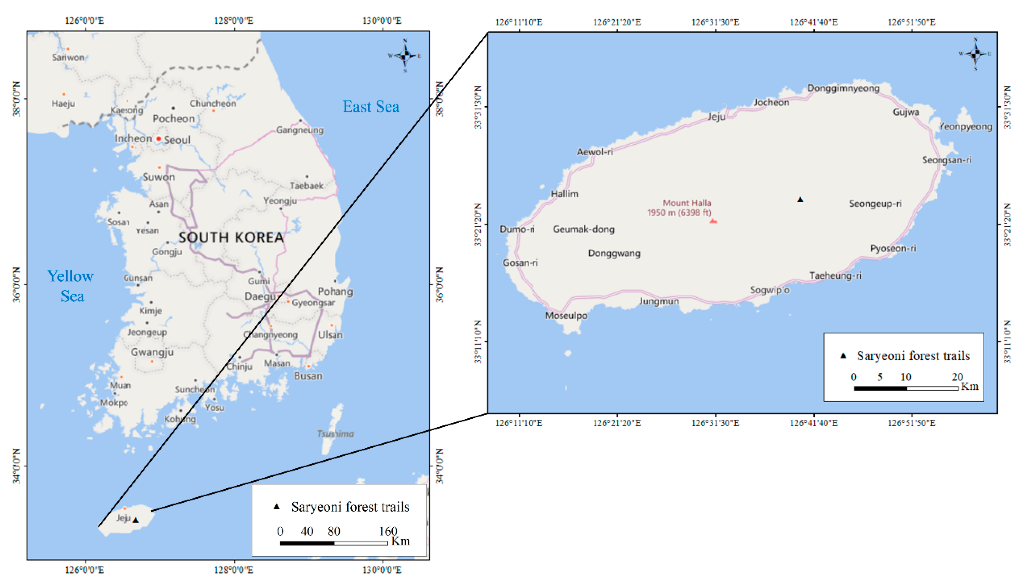
2.1. Study Area

To evaluate the applicability of a sample point forest survey using BPLS, this study was performed at Saryeoni Forest, a Cryptomeria japonica plantation located in Jeju-do, South Korea. Low in understory vegetation distribution, the Saryeoni Forest has the coordinates 33°23′31.8″ N, 126°40′17.8″ E (lat: 33.39216667, long: 126.6716111) (Figure 1).

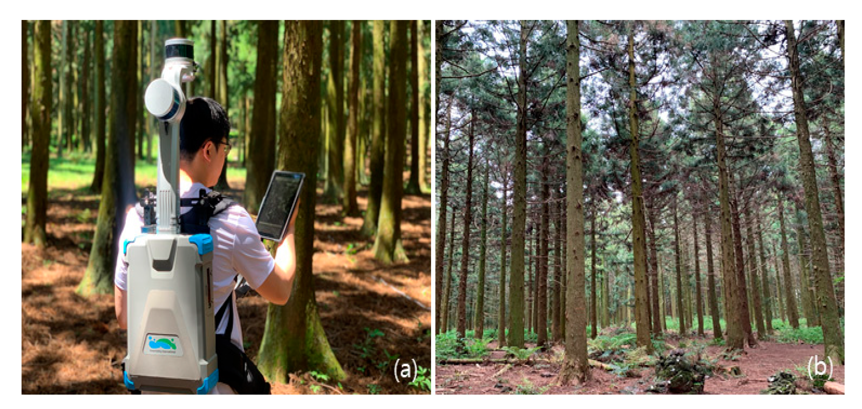
2.2. Data Collection Field Survey and Using BPLS

Data collection was conducted in June 2020. The sampling plot was a square (20 m × 20 m) of 0.04 ha and was divided into four according to stand density. The details of the sample points are listed in Table 1.
A field survey was conducted using Hagröf’s Vertex Laser Geo (Haglöf Sweden AB, Långsele, Sweden) [19], a traditional forest survey equipment, and DBH was measured using a steel tape (Table 2).
The method using laser scanning is influenced by the weather. Rain and snow affect the scattering properties of pulses, and especially wind can cause crowns to move, producing outliers in the point cloud. Seidel et al. [20] recommended scanning within 5 m/s of wind speed. In this study, the average wind speed between the tasks was investigated using Kestrel3000 (Kestrel, Boothwyn, PA, USA). Scanning was then performed under the conditions where wind speed was less than 5 m/s, thus implying that the impact of wind was not significant in this paper.
The BPLS device used was the Green Valley International’s model Libackpack D50 (California, USA) [21] with the following specifications (Table 3).
The D50 has two laser scanners mounted on the backpack vertically and horizontally; thus, the main scanner collects data horizontally, while the secondary scanner collects data vertically, making it easier to acquire data (Figure 2). As no data collection process via a BPLS is present, the data acquisition method was set to seven patterns considering the density of the sample points and the work efficiency. Using the BPLS, a user delineates pattern 1 by walking along the boundaries of the plot in an attempt to minimize blind spots. An additional diagonal path or paths were added to pattern 1 in patterns 2 and 3. To study the effect of scan density on the accuracy, 5–10 m interval paths were set for patterns 4–7. Patterns 5 and 7 were formed by combining pattern 1 with various scan density patterns to determine the necessity of path closure and its effect on LiDAR data accuracy (Figure 3).

2.3. Comparison of BPLS Measurements and Field Survey Methods

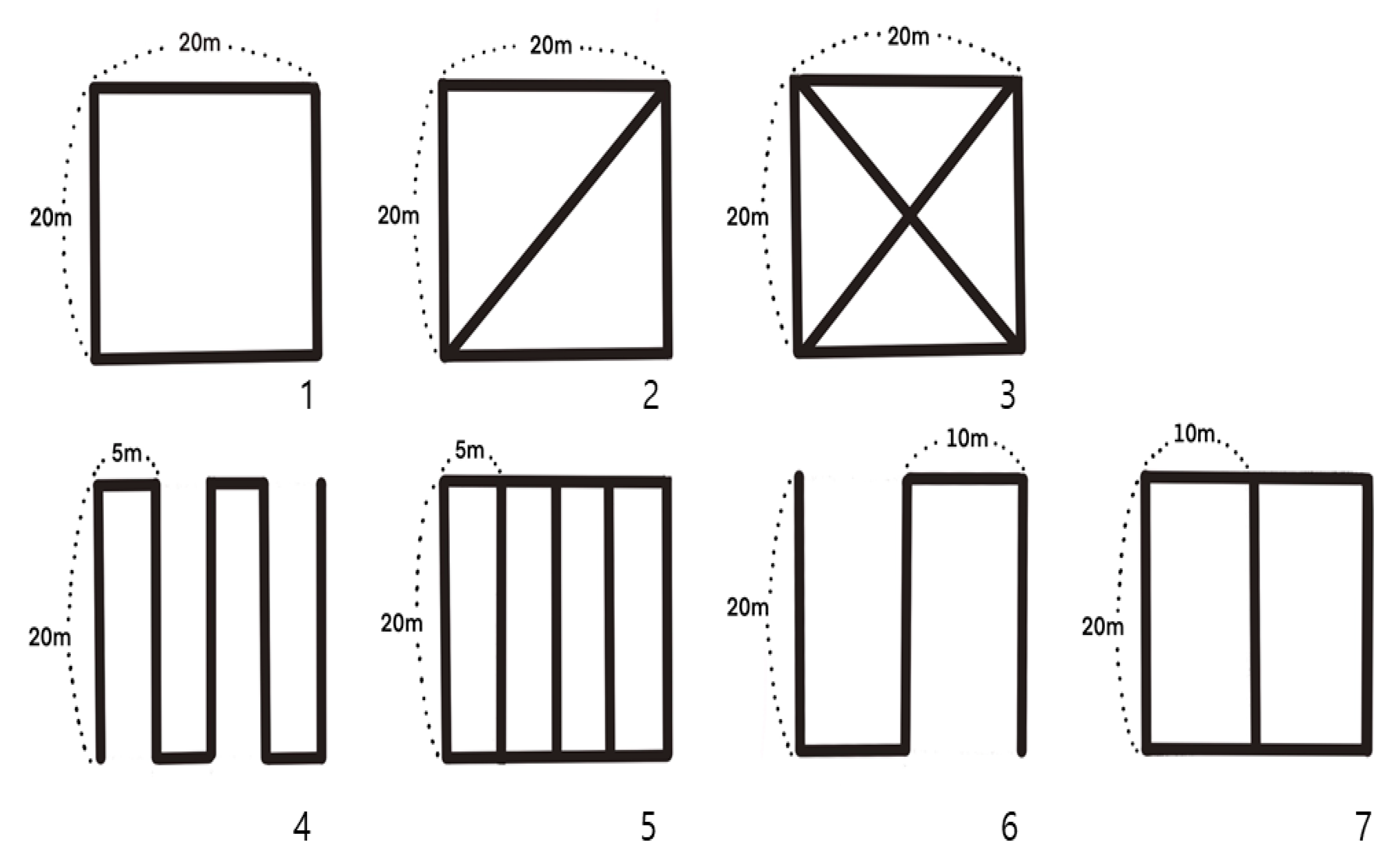
2.3.1. Performance Measurement (Time Study)

The forest survey was divided into field work carried out at the site and office work in the laboratory. The field survey was conducted by a group of three researchers, one of them was a recorder. Another researcher measured DBH values, while height was estimated by the third researcher. A backpack-typed LiDAR scan, on the other hand, was conducted by one person (Table 4). To analyze the overall work time, a stopwatch was used to measure the time spent on the field survey and acquiring a pattern-specific point cloud. There was no difference in the time spent segmenting in both the field survey and the LiDAR survey. The on-site inspection conducted a survey on the time spent by filling out the field information in Excel. The data were investigated with respect to the time per component task and the overall time spent on being analyzed by the LiDAR360 software program [22].

2.3.2. Data Processing Using BPLS Survey Data

Each plot was divided so that it became clear where point clouds collected by the BPLS were present and where a specific moving path was set. Outliers caused by laser pulses with multiple paths were eliminated using a function to remove outliers and the noise filter of the LiDAR360 software was used to enhance the quality of the data. Point clouds were classified into aboveground and ground parts by utilizing a triangulated irregular network algorithm (TIN) after the outliers were removed. Standing trees were then identified through a comparative shortest-path algorithm (CSP) which was used for space clustering. Next, the DBH value was then estimated by extracting a 10 cm-long slice at 1.2 m of the identified stem [23]. A point cloud is a set of data points that have their own x, y, and z coordinates. Once individual trees were identified, the height can be estimated by the difference between the point clouds found in the top and the bottom of the tree. In other words, the height was calculated using the z coordinates of the point clouds. The efficiency of processing data with an enormous number of point clouds depends on the specifications of a computer because of the immense quantity of data. The major specifications of the workstation employed in this research are CPU Xeon (R) E5-1620 V3 3.50 GHz, RAM 128 GB, GPU NVIDIA Quadro K1200, and Windows 10 (64-bits) as the operating system.
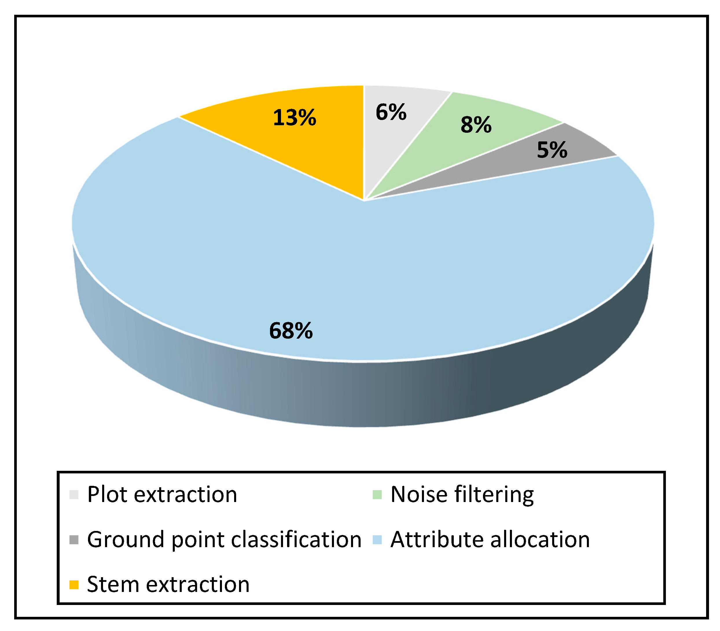
  • The work at the office using a BPLS is defined as the following:
    • Plot extraction—extracting only points within a sample point (20 m × 20 m) of the entire point cloud.
    • Noise filtering—removing outliers caused by multipath effects of laser pulses from the data Tasks to improve quality.
    • Ground point classification—the task of separating terrain using the triangulated irregular network (TIN) algorithm.
    • Attribute allocation—tasks that give each point cloud a property value for (e.g., entry, understory vegetation, buildings, etc.).
    • Stem extraction—extracting stands using the CSP algorithm.

2.4. Accuracy Assessment

DBH and height estimated by BPLS were evaluated using root mean square error (RMSE), RMSE%, bias, and bias%. RMSE is a value used to check the precision by examining the difference between measurements and estimates from the center, and bias is used to determine the degree of overestimation or underestimation of estimates relative to measurements. This is a commonly used measure when dealing with differences between estimates and measurements, and the closer to zero the value is, the higher its determined quality. In this study, the field data were set as the reference value, with the BPLS data evaluated by setting it as an estimated value (Table 5).

3. Results and Discussion

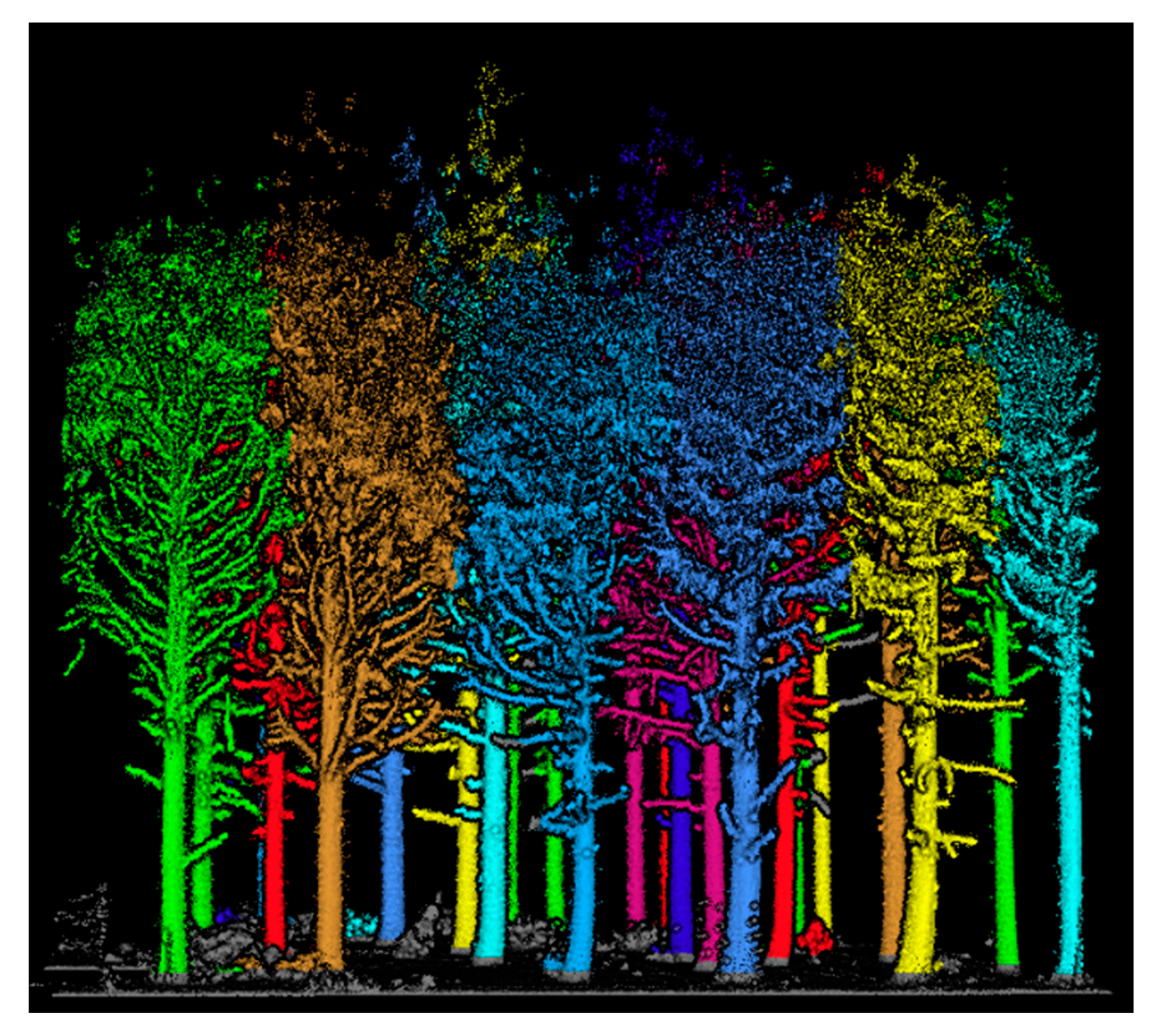
3.1. Stem Mapping Results

A total of 157 trees were present in the sample plots. The point cloud data obtained with D50 displayed a 100% detection rate from the four sample plots. BPLS is a device that allows a user to acquire terrain and tree information while walking, without being affected by the occlusion effect. Previous studies have noted that the mapping process using LS technology (ALS, TLS, MLS, and PLS) is heavily affected by the stand density [4]. Stand density in a given sample plot appeared to be inversely proportional to the detection rate. Chen et al. [4] utilized a ZEB-REVO-RT, a PLS device with high mobility, in Chinese pine and birch plots with a density of 1100/ha, and attained a detection rate of 90.9%, 9.1% short of 100%. Oveland et al. [24] used TLS, MLS, and BPLS and obtained the highest rate of 87.5% during surveys in five different sample plots with varying stand densities (from 380 to 1380/ha). Bauwens et al. [10] utilized FARO Focus 3D, a TLS, and ZEB1, an MLS, to examine eight different deciduous and coniferous plots with different stand densities (113–1344/ha) and attained average detection rates of 42% and 91% for FARO and ZEB1, respectively. Hyyppä et al. [25] analyzed the detection performance by using a BPLS in the Finnish tundra and obtained 95% and 84% detection rates for low and high understory vegetation plots, respectively.
Compared to the results of existing studies, the device used in this study displayed marginally higher performance. This improvement is attributed to the low slope and little understory vegetation. The enhanced performance can also be explained by the data collection using BPLS being considered more efficient with a relatively large DBH with a low stand density. Moreover, when compared with TLS and MLS, the BPLS is more competent in surveying tree stems in forests.

3.2. Comparison of DBH and Height Measurements between BPLS and Field Survey Methods

The test statistics values obtained by comparing the DBH and height data are presented in Table 6.
For DBH, the RMSE ranged from 1.22 to 1.40 cm, RMSE% from 4.69% to 6.04%, bias from −1.06 to −0.87 cm, and bias% from −5.07% to −3.75%. Overall, the estimation using the traditional field survey method and BPLS revealed high compatibility. For bias and bias%, the values tended to be negative. A stem is shaped more of an oval than a circle because of the irregular shapes of stems and bark. Measurements of DBH using BPLS are deemed different because its algorithm estimates the exact circle by taking only the 1.2 m point cloud from the surface. Korea’s forest management plan accepts RMSE values within a range of ±2 cm, and since the acquired RMSE values in this study were in the range of 1.22 to −1.40 cm, the results of this study are significant and warrant inclusion in a future forest management plan.
The results of this study are included in the DBH measurement using LiDAR, in which Liang et al. [26] indicated that RMSE% in visible forests is allowed in the range of 5–10%. Compared with prior research results, Oveland et al. [24] compared the efficacy of three different equipment: TLS, HMLS, and BPLS. The results were as follows: RMSE of 6.2 cm and RMSE% of 28.6% for TLS, RMSE of 3.1 cm and RMSE% of 14.3% for HMLS, and RMSE of 2.2 cm and RMSE% of 9.1% for BPLS. Furthermore, when DBH was estimated using MLS and PLS, the DBH was measured at a significantly higher level than the results of bias% ranging between −2 and −5%, and RMSE% ranging between 8 and 29% [27,28]. Conversely, the results of this study are significantly higher.
The height was between 1.48 and 1.93 m for RMSE, 6.24% to 7.19% for RMSE%, −1.61 m to −1.18 m for bias, and −5.42% to −4.46% for bias%. Overall, a high accuracy was obtained, however, not as precise as that of the DBH. Estimating the height by observing the top of the stand using TLS data has been studied for many standard sites using multiple scanning equipment [29,30]. Bauwens et al. [10] also reported that most laser signals have difficulty obtaining a height of 15–20 m. Huang et al. [29] acquired an MS method using TLS at RMSE 0.8 m and bias −0.3 m, and Liang and Hyyppä [31] at RMSE 2.04–6.53 m, RMSE% 12.47–34.11%, and bias 1.16–2.11 m. Del Perugia et al. [18] used HMLS according to scan density to investigate different scan densities of 10 m and 15 m for stands of less than 15 m in a plot at 10 m intervals (RMSE 0.67 m, RMSE% 6.52%, and bias 0.17 m) and 15 m intervals (RMSE 0.82 m, RMSE% 7.78%, and bias 0.44 m).
As for estimating the height, the LS technology is less accurate than the DBH estimation because the technology using vertices is more sensitive to the user, stand conditions, stem width, and species [32]. Conversely, it is more difficult to directly estimate the height in a dense forest because the surrounding stands may block the view. The height measurements using LS equipment displayed that the top of the stand was undervalued compared to that in the field survey method, and much of the top portion of the stand data could not be acquired (Figure 4).
Upon comparing the DBH and height values by pattern, it was observed that the patterns displayed high overall accuracy, while patterns 5 and 7 achieved the highest accuracy. This is attributed to the fact that patterns 5 and 7 require longer distances traveled during forest surveys, and the number of points acquired is larger than in the other patterns. Additionally, the accuracy of BPLS appears to have been improved because it is close to match the start and endpoints of the survey plot, unlike pattern 4 (5 m intervals) and pattern 6 (10 m intervals) set at the same interval.

3.3. BPLS Estimation and Field Survey Method Efficiency Comparison

The entire survey time was recorded to analyze the efficiency of each survey method. Both methods were applied to the same plots (20 m × 20 m), and the time to extract the individual stands was recorded after dividing them into field and office works. The time required for data acquisition by the two methods is presented in Table 7 and Table 8.
Comparing the time by pattern (Table 7), the time spent on the field work for the measurement method using BPLS equipment was between 03:04–06:29 min, and the longer the distances traveled, the more time the investigation took. Furthermore, the longer the distances traveled, the more points were acquired, and the positive correlation between the survey time and the capacity of the data revealed that pattern 5 acquired the largest quantity of data. The comparison of distances traveled per hour revealed that pattern 5 was the fastest, indicating 9.2 m/min, followed by pattern 7 with 8.96 m/min. A comparison of areas per hour indicated that pattern 1 was the widest at 27.51 m2/min, followed by pattern 6 at 26.04 m2/min. However, compared with both the distances traveled per hour and the area per hour pattern 7 is deemed the most efficient method because it requires little time despite its long distances traveled.
In regards to field work, Table 8 reveals an average of 15 min difference between the field survey method and the forest resource survey using BPLS (Table 8). Based on the calculation of the time taken to process 1 ha of data using BPLS and on-site surveys, BPLS takes between 115–162.5 min, while a field survey method takes between 322.5–567.5 min. The field survey method took approximately 3.8 times longer, indicating the efficiency of the BPLS method. The average time elapsed to attain results may vary depending on the site’s environmental conditions. Consistent with the results of this study, in a previous study, the scan time using TLS was 130–200 min/ha [10,28,33]. It should, however, be noted that the results presented in this research are limited to those acquired with Green Valley International’s BPLS device Libackpack D50. The accuracy or efficiency may vary depending on other LiDAR equipment and computer specifications.
Plot 4, which had fewer stands, took more time overall for the BPLS method than the field survey method, which immediately acquired variables such as height and DBH at the site, indicating a significant decrease in the number of outdoor hours compared to those for the other sites. BPLS is less affected by this number, while it is heavily influenced by stand conditions. As a result, the field survey method took up more time than the office work, and the opposite trend was observed for the BPLS method.
By utilizing the BPLS method, data are quickly acquired from the surrounding environment through continuous scans, with the operator moving. The collected points can be examined in the field through smartphones and tablet screens, which has the advantage of being able to check the stability of the data and whether additional data collection is needed. However, pre-processing is required to extract variables by separating the data collected from the device into objects. Pre-processing work to extract variables is done in the order of survey site compartment, aberration, terrain separation, attribute assignment, and object extraction, and variables in the stand are then measured during the work. Comparing the component-to-task time of pre-processing work using BPLS revealed that more acquired points entailed longer processing times. Particularly, attribute assignment, which gives attribute values to the point cloud, accounted for the largest portion of the total office work time at approximately 68% or more (Figure 5).
This is thought to have a significant effect on the task time due to the inhibitions in attribute assignment tasks (understory vegetation, obstacles, etc.) compared to the density and stand patterns.
A comparison of the total survey time of one minute per surveyor showed that (Table 8) the BPLS average is 22.5 m2/min and the field survey average is 5.6 m2/min, allowing approximately four times the area to be investigated in the same time given. Chen et al. [4] compared the field survey method with ZEB-REVO-RT, a handheld PLS equipment, and the field survey method was found to be more efficient than the field survey method, although for the PLS 30 m2/min was obtained and for the field survey 0.91 m2/min was obtained.
As a result, BPLS, which can be used by one person, was found to be more efficient compared to the same area and time compared to the field survey method conducted by a group of three members. In addition, a field survey can be obtained immediately, mainly by identifying variables such as DBH and height at the site, but it needs to be data-driven. On the other hand, data collected by LS devices, such as BPLS, cannot be acquired immediately on site, and additional processing is required as a task to obtain variables. However, for field investigation methods, only variables investigated in the field can be acquired, but BPLS can acquire additional variables for user-defined purposes and by-work as needed. Furthermore, it is judged that the method using BPLS is very useful in terms of the time it takes to collect the data. Therefore, BPLS is thought to have great potential in performing forest resource surveys in a cost-effective way.

4. Conclusions

This study was conducted to compare forest resource survey methods to measure major variables such as DBH and height at the plot level using a BPLS. The existing forest survey method for measuring DBH using a diameter tape and a caliper is cost-efficient, fast, and accurate. However, it is not possible to estimate additional information, such as stem diameter per height, because the measurements are limited to the height accessible by the user. However, these problems can be solved by utilizing the LS equipment. Much attention has been paid to LS equipment as a technology for obtaining precise properties of forest trees in forest resource surveys, and it is gradually evolving from manual measurements to automatic measurements. This not only yields variables that existing field survey methods cannot measure (e.g., crown width, crown area, stem slopes, branch angles, etc.) but also has the advantage of estimating variables in forests in a non-destructive manner and identifying time-dependent changes in forests.
Therefore, it is believed that a variety of variables in the area can be acquired in less time than the existing forest measurement method. In pattern-by-pattern comparisons, pattern 7 was judged to be the most efficient because of the large area to be investigated over time, despite the distance traveled compared to other patterns. In this study, pattern 7 was judged to be the most efficient method for forest resource surveys using a BPLS by comparing accuracy and time-efficiency.
On-site surveys were recorded on paper at the site and manually recorded in the database. Therefore, the possibility of input errors cannot be ruled out, along with other measurement errors from DBH, height, and miscellaneous error tilting of wood during this process. However, the measurement of variables by LS has the advantage that all algorithms are applied to the same data, thereby reducing measurement and input errors.
Consequently, forest surveys using BPLS are exceptionally useful for reducing the time required to collect data. This will support forest management plans by providing accurate and timely information on forest resource surveys. Particularly, it is believed to have greater potential in a more efficient way regarding cost and manpower reduction than existing forest surveys. These findings could contribute to developing a manual that is used for investigation using BPLS devices in the future.

Author Contributions

Conceptualization, C.K. and J.K.; methodology, C.K. and S.L.; software, C.K. and S.L.; validation, C.K. and D.K.; formal analysis, C.K.; investigation, C.K.; resources, J.Y.; data curation, C.K.; writing—original draft preparation, C.K.; writing—review and editing, C.K. and D.K.; visualization, C.K. and S.L.; supervision, C.K.; project administration, J.K.; funding acquisition, J.K. All authors have read and agreed to the published version of the manuscript.

Funding

This research was funded by the National Institute of Forest Science, grant number FM0000-2020-01-2021.

Institutional Review Board Statement

Not applicable.

Informed Consent Statement

Not applicable.

Acknowledgments

This study was supported by the R&D Program for Forest Science Technology (Project No. FM0000-2020-01-2021) provided by the National Institute of Forest Science.

Conflicts of Interest

The authors declare no conflict of interest.

References

  1. Hyyppä, E.; Kukko, A.; Kaijaluoto, R.; White, J.C.; Wulder, M.A.; Pyörälä, J.; Liang, X.; Yu, X.; Wang, Y.; Kaartinen, H.; et al. Accurate derivation of stem curve and volume using backpack mobile laser scanning. ISPRS J. Photogramm. Remote Sens. 2020, 161, 246–262. [Google Scholar] [CrossRef]
  2. Rutzinger, M.; Pratihast, A.K.; Oude Elberink, S.; Vosselman, G. Detection and modelling of 3D trees from mobile laser scanning data. Int. Arch. Photogramm. Remote Sens. Spat. Inf. Sci. 2010, 38, 520–525. [Google Scholar]
  3. Maltamo, M. Forestry Applications of Airborne Laser Scanning: Concepts and Case Studies; Springer: Dordrecht, The Netherlands, 2014. [Google Scholar]
  4. Chen, S.; Liu, H.; Feng, Z.; Shen, C.; Chen, P. Applicability of personal laser scanning in forestry inventory. PLoS ONE 2019, 14, e0211392. [Google Scholar] [CrossRef]
  5. Ayrey, E.; Hayes, D.J. The Use of Three-Dimensional Convolutional Neural Networks to Interpret LiDAR for Forest Inventory. Remote. Sens. 2018, 10, 649. [Google Scholar] [CrossRef] [Green Version]
  6. Erikson, M.; Karin, V. Finding tree-stems in laser range images of young mixed stands to perform selective cleaning. In Proceedings of the ScandLaser Scientific Workshop on Airborne Laser Scanning of Forest, Umea, Sweden, 3–4 September 2003. [Google Scholar]
  7. Lovell, J.L.; Jupp, D.L.; Culvenor, D.S.; Coops, N.C. Using airborne and ground-based ranging lidar to measure canopy structure in Australian forests. Can. J. Remote Sens. 2003, 29, 607–622. [Google Scholar] [CrossRef]
  8. Hopkinson, C.; Chasmer, L.; Young-Pow, C.; Treitz, P. Assessing forest metrics with a ground-based scanning lidar. Can. J. For. Res. 2004, 34, 573–583. [Google Scholar] [CrossRef] [Green Version]
  9. Liang, X.; Kankare, V.; Hyyppä, J.; Wang, Y.; Kukko, A.; Haggrén, H.; Yu, X.; Kaartinen, H.; Jaakkola, A.; Guan, F.; et al. Terrestrial laser scanning in forest inventories. ISPRS J. Photogramm. Remote Sens. 2016, 115, 63–77. [Google Scholar] [CrossRef]
  10. Bauwens, S.; Bartholomeus, H.; Calders, K.; Lejeune, P. Forest inventory with terrestrial LiDAR: A comparison of static and hand-held mobile laser scanning. Forests 2016, 7, 127. [Google Scholar] [CrossRef] [Green Version]
  11. Brolly, G.; Király, G. Algorithms for stem mapping by means of terrestrial laser scanning. Acta Silv. Lignaria Hung. 2009, 5, 119–130. [Google Scholar]
  12. Murphy, G.E.; Acuna, M.A.; Dumbrell, I. Tree value and log product yield determination in radiata pine (Pinus radiata) plantations in Australia: Comparisons of terrestrial laser scanning with a forest inventory system and manual measurements. Can. J. For. Res. 2010, 40, 2223–2233. [Google Scholar] [CrossRef]
  13. Lovell, J.; Jupp, D.; Newnham, G.; Culvenor, D. Measuring tree stem diameters using intensity profiles from ground-based scanning lidar from a fixed viewpoint. ISPRS J. Photogramm. Remote Sens. 2011, 66, 46–55. [Google Scholar] [CrossRef]
  14. Kukko, A. Mobile laser scanning—System development, performance and applications. Ph.D. Thesis, Aalto University, Espoo, Finland, 2013. [Google Scholar]
  15. Liang, X.; Kukko, A.; Kaartinen, H.; Hyyppä, J.; Yu, X.; Jaakkola, A.; Wang, Y. Possibilities of a personal laser scanning system for forest mapping and ecosystem services. Sensors 2014, 14, 1228–1248. [Google Scholar] [CrossRef]
  16. Saarela, S.; Breidenbach, J.; Raumonen, P.; Grafström, A.; Ståhl, G.; Ducey, M.J.; Astrup, R. Kriging prediction of stand-level forest information using mobile laser scanning data adjusted for nondetection. Can. J. For. Res. 2017, 47, 1257–1265. [Google Scholar] [CrossRef]
  17. Cabo, C.; Pozo, S.D.; Rodríguez-Gonzálvez, P.; Ordóñez, C.; González-Aguilera, D. Comparing terrestrial laser scanning (TLS) and wearable laser scanning (WLS) for individual tree modeling at plot level. Remote Sens. 2018, 10, 540. [Google Scholar] [CrossRef] [Green Version]
  18. Del Perugia, B.; Giannetti, F.; Chirici, G.; Travaglini, D. Influence of scan density on the estimation of single-tree attributes by hand-held mobile laser scanning. Forests 2019, 10, 277. [Google Scholar] [CrossRef] [Green Version]
  19. The VL Vertex Laser. Available online: http://www.haglofcg.com/index.php/en/files/leaflets/46-vl5-product-sheet (accessed on 28 January 2021).
  20. Seidel, D.; Fleck, S.; Leuschner, C. Analyzing forest canopies with ground-based laser scanning: A comparison with hemispherical photography. Agric. For. Meteorol. 2012, 154-155, 1–8. [Google Scholar] [CrossRef]
  21. LiBackpack—Mobile Handheld LiDAR—3D Mapping System. Available online: https://greenvalleyintl.com/hardware/libackpack/ (accessed on 1 February 2021).
  22. LiDAR360—Point Cloud Processing Software. Available online: https://greenvalleyintl.com/software/lidar360/ (accessed on 1 February 2021).
  23. Tao, S.; Wu, F.; Guo, Q.; Wang, Y.; Li, W.; Xue, B.; Hu, X.; Li, P.; Tian, D.; Li, C.; et al. Segmenting tree crowns from terrestrial and mobile LiDAR data by exploring ecological theories. ISPRS J. Photogramm. Remote Sens. 2015, 110, 66–76. [Google Scholar] [CrossRef] [Green Version]
  24. Oveland, I.; Hauglin, M.; Giannetti, F.; Kjørsvik, N.S.; Gobakken, T. Comparing three different ground based laser scanning methods for tree stem detection. Remote Sens. 2018, 10, 538. [Google Scholar] [CrossRef] [Green Version]
  25. Hyyppä, E.; Yu, X.; Kaartinen, H.; Hakala, T.; Kukko, A.; Vastaranta, M.; Hyyppä, J. Comparison of backpack, handheld, under-canopy UAV, and above-canopy UAV laser scanning for field reference data collection in boreal forests. Remote Sens. 2020, 12, 3327. [Google Scholar]
  26. Liang, X.; Wang, Y.; Pyörälä, J.; Lehtomäki, M.; Yu, X.; Kaartinen, H.; Kukko, A.; Honkavaara, E.; Issaoui, A.E.I.; Nevalainen, O.; et al. Forest in situ observations using unmanned aerial vehicle as an alternative of terrestrial measurements. For. Ecosyst. 2019, 6, 20. [Google Scholar] [CrossRef] [Green Version]
  27. Liang, X.; Wang, Y.; Jaakkola, A.; Kukko, A.; Kaartinen, H.; Hyyppä, J.; Honkavaara, E.; Liu, J. Forest data collection using terrestrial image-based point clouds from a handheld camera compared to terrestrial and personal laser scanning. IEEE Trans. Geosci. Remote Sens. 2015, 53, 5117–5132. [Google Scholar] [CrossRef]
  28. Ryding, J.; Williams, E.; Smith, M.; Eichhorn, M. Assessing handheld mobile laser scanners for forest surveys. Remote Sens. 2015, 7, 1095–1111. [Google Scholar] [CrossRef] [Green Version]
  29. Huang, H.; Li, Z.; Gong, P.; Cheng, X.; Clinton, N.; Cao, C.; Ni, W.; Wang, L. Automated methods for measuring DBH and tree heights with a commercial scanning lidar. Photogramm. Eng. Remote Sens. 2011, 77, 219–227. [Google Scholar] [CrossRef]
  30. Fleck, S.; Mölder, I.; Jacob, M.; Gebauer, T.; Jungkunst, H.F.; Leuschner, C. Comparison of conventional eight-point crown projections with LIDAR-based virtual crown projections in a temperate old-growth forest. Ann. For. Sci. 2011, 68, 1173–1185. [Google Scholar] [CrossRef] [Green Version]
  31. Liang, X.; Hyyppä, J. Automatic stem mapping by merging several terrestrial laser scans at the feature and decision levels. Sensors 2013, 13, 1614–1634. [Google Scholar] [CrossRef] [PubMed] [Green Version]
  32. Wang, Y.; Lehtomäki, M.; Liang, X.; Pyörälä, J.; Kukko, A.; Jaakkola, A.; Liu, J.; Feng, Z.; Chen, R.; Hyyppä, J. Is field-measured tree height as reliable as believed—A comparison study of tree height estimates from field measurement, airborne laser scanning and terrestrial laser scanning in a boreal forest. ISPRS J. Photogramm. Remote Sens. 2019, 147, 132–145. [Google Scholar] [CrossRef]
  33. Giannetti, F.; Chirici, G.; Gobakken, T.; Næsset, E.; Travaglini, D.; Puliti, S. A new approach with DTM-independent metrics for forest growing stock prediction using UAV photogrammetric data. Remote Sens. Environ. 2018, 213, 195–205. [Google Scholar] [CrossRef]
Figure 1. Location of study area in Jeju Island, South Korea.
Forests 12 00308 g001
Figure 2. Photograph of survey using Libackpack D50 (a) and the Saryeoni forest (b).
Forests 12 00308 g002
Figure 3. Survey paths used for scans with backpack personal laser scanning (BPLS) device. Walking along the plotline (pattern 1), a diagonal path added to pattern 1 (pattern 2), two diagonal lines added to pattern 1 (pattern 3), walking back and forth along straight lines at the interval of 5 m (pattern 4), a combination of pattern 1 and pattern 4 (pattern 5), walking back and forth along straight lines at the interval of 10 m (pattern 6), and a combination of pattern 1 and pattern 6 (7).
Forests 12 00308 g003
Figure 4. Tree extraction using LiDAR360 software.
Forests 12 00308 g004
Figure 5. Analysis of time spent on each process in office work with BPLS data (%).
Forests 12 00308 g005
Table 1. Geographical characteristics per plot of study area.
Plot No.Plot Size [ha]Altitude [m]Slope [°]Wind Speed [m/s]
10.0445533
245121
344824
443625
Table 2. Summary of statistics for sample trees in each sample plot.
Plot No.VariableNumber of TreesMeanStd.MinMax
Dev.
1DBH (cm)4330.76.316.343.4
Height (m)20.71.016.923.1
2DBH (cm)3633.65.122.444
Height (m)20.21.018.124.5
3DBH (cm)5227.55.316.539
Height (m)19.21.216.822.2
4DBH (cm)2637.86.12850.2
Height (m)18.82.49.521.3
Table 3. Technical specifications of the backpack personal laser scanning device (BPLS, Libackpack D50).
Specifications
Laser SensorVelodyne VLP-16 × 2
LiDAR Accuracy±3 cm
Scan Range100 m
Weight8.8 kg without battery
Scan Rate600,000 pts/s
Table 4. Survey methods categorized by tools.
Survey MethodTotal Time Elapsed
Field WorkOffice Work
Traditional field surveyPlot extraction
Height estimation
DBH estimation
Digitization of field measurement
BPLSPlot estimation
point cloud acquisition
Variable extraction using point cloud
Table 5. Accuracy of BPLS and field measurements.
StatisticsEquation
Bias i = 1 n ( x i x i ^ ) / n
Bias% B i a s x i ¯ × 100 %
Root mean square error(RMSE) i = 1 n ( x i x i ^ ) 2 n
RMSE% R M S E x i ¯ × 100 %
Where x i , x i ^ , x i ¯ = measurements (BPLS), reference value (field survey), and mean of the reference (field survey), value. n = the number of trees.
Table 6. Comparison and accuracy assessment of values between two survey methods (DBH, Height).
Pattern
1234567
DBH [cm]RMSE1.401.361.281.241.221.291.23
RMSE%6.045.485.585.255.255.254.69
Bias−1.03−1.06−0.90−0.87−0.90−0.95−0.92
Bias%−5.07−4.59−4.80−4.61−3.75−4.58−3.92
Height [m]RMSE1.931.751.81.691.661.651.48
RMSE%7.196.986.556.386.246.636.3
Bias−1.61−1.47−1.55−1.45−1.18−1.44−1.23
Bias%−5.31−5.42−4.63−4.46−4.62−4.85−4.73
Table 7. The amount of the time elapsed on patterns and the number of point clouds acquired.
PatternArea
[m2]
Distances Traveled [m]Time Consumption [min.s]Total Point Cloud [n]Efficiency by the Distance Covered Per Minute
[m/min]
Efficiency by the Area Covered Per Minute [m2/min]
SurveyProcessingTotal
Times
(A)(B) (C) (D) = (B)/(C)(E) = (A)/(C)
14008004:1110:2014:324,292,798 5.5027.51
2108.304:4012:0416:445,755,082 6.4723.89
3136.603:4714:1318:017,942,039 6.8219.98
412003:0413:5416:587,306,799 6.3221.07
520006:2915:1421:4410,249,218 9.2018.40
68004:0511:1615:214,992,602 5.2126.04
716005:2312:2417:478,083,810 8.9622.40
Table 8. Comparison of efficiency between field survey and BPLS survey.
Survey MethodPersonnelPlot No.Area
(m2)
Time Consumption (min.s)(m2/min)
SurveyProcessingTotal
Field
survey
3140020:425:3626:185.1
222:423:4826:365.0
322:186:0028:244.7
412:544:0016:547.9
BPLS1104:4211:0015:4225.5
206:3011:2417:5422.3
304:5413:3018:2422.1
404:3615:1819:5420.2
Publisher’s Note: MDPI stays neutral with regard to jurisdictional claims in published maps and institutional affiliations.

