
The Human Dimensions of Spatial, Pre-Wildfire Planning Decision Support Systems: A Review of Barriers, Facilitators, and Recommendations

Ecological Restoration Institute, Northern Arizona University, Flagstaff, AZ 86011, USA
Forests 2021, 12(4), 483; https://0-doi-org.brum.beds.ac.uk/10.3390/f12040483
Submission received: 5 March 2021
/
Revised: 9 April 2021
/
Accepted: 9 April 2021
/
Published: 14 April 2021
(This article belongs to the Special Issue Decision Support System Development of Wildland Fire)
Abstract
:Decision support systems (DSSs) are increasingly common in forest and wildfire planning and management in the United States. Recent policy direction and frameworks call for collaborative assessment of wildfire risk to inform fuels treatment prioritization using the best available science. There are numerous DSSs applicable to forest and wildfire planning, which can support timely and relevant information for decision making, but the use and adoption of these systems is inconsistent. There is a need to elucidate the use of DSSs, specifically those that support pre-wildfire, spatial planning, such as wildfire risk assessment and forest fuels treatment prioritization. It is important to understand what DSSs are in use, barriers and facilitators to their use, and recommendations for improving their use. Semi-structured interviews with key informants were used to assess these questions. Respondents identified numerous barriers, as well as recommendations for improving DSS development and integration, specifically with respect to capacity, communication, implementation, question identification, testing, education and training, and policy, guidance, and authorities. These recommendations can inform DSS use for wildfire risk assessment and treatment prioritization to meet the goals of national policies and frameworks. Lastly, a framework for organizing spatial, pre-wildfire planning DSSs to support end-user understanding and use is provided.
1. Introduction
Wildfire management is growing increasingly challenging as longer, more complex fire seasons demand additional resources and highlight the need for new strategies that acknowledge the role of fire and importance of adapting to wildfire [1]. Fire managers are working with partners and stakeholders to collaboratively and spatially assess wildfire risk using the best available science and technology, as well as facilitate decisions about where to prioritize fuels treatments to reduce the risk of fires before they start [2,3,4,5]. A growing number of policies, frameworks, and guidance documents in the United States (U.S.) articulate a need for collaborative, spatial, pre-fire planning in varying ways, including the National Cohesive Wildland Fire Management Strategy (Cohesive Strategy), Forest Service Manual Chapter 5140, Forest Service Shared Stewardship Initiative, and the 2018 Omnibus Spending Bill (PL115-141) to name a few [6,7,8,9]. At the same time, there are numerous analysis methods, tools, and geographic and temporal scales for modeling wildfire behavior, assessing fire risk, and prioritizing areas for treatment [10,11]. This can lead to confusion and other challenges in using decision support systems (DSSs) and decision support tools (DST) to assess wildfire risk and inform treatment prioritization, as well as in tactical settings on fires [12,13]. Thus, there is a need to elucidate the use of spatial, pre-fire planning DSSs and DSTs for assessing wildfire risk and determining areas for fuels treatment prioritization to facilitate collaborative, science-based pre-fire planning in the U.S. and elsewhere.
It is important to define key terms and develop a common language to talk about risk in wildland fire planning and management [14] (Table 1). The term used most prominently in this paper is “decision support system”, which broadly refers to the different frameworks, models, analysis methods, and products or decision support tools (i.e., software) that provide information about wildfire risk assessment and treatment prioritization to support strategic, risk-informed pre-fire planning (Table 1). In general, DSSs are computer-based systems that provide informational outputs like spatial data layers that characterize areas according to wildfire risk or highlight potential areas for prioritized forest restoration or fuels reduction work. The term DSS may not adequately capture the complexity of different spatial, pre-fire planning frameworks, methods, and tools, and new terminology may be warranted to describe the full realm of approaches [13]. Definitions are also discussed in the Results. Other key terms used in this paper include “wildfire risk assessment” and “treatment prioritization.” The distinction between wildfire risk assessment and treatment prioritization can be indeterminant depending on the underlying risk science paradigm, as they are related concepts. However, for the purposes of this paper, wildfire risk assessment refers to approaches that explicitly model fire and its behavior, while treatment prioritization refers to approaches that are more focused on fuel (i.e., vegetation) and the hazards it can create when fire is present.
Land management agencies like the U.S. Department of Agriculture Forest Service (hereafter: Forest Service) are required by numerous laws, policies, and guidance to use the best available scientific information (BASI) in decision making about the planning for and implementation of forest management treatments to restore forest health and reduce the risk of catastrophic wildfire [15]. BASI also includes technologies like DSSs that can inform forest and fire management decision making. However, the use of BASI is complicated by other decision-making considerations, such as resource availability, funding, end user perceptions of science, uncertainty, limited understanding of how to apply BASI, and BASI that is poorly conceived for end users, among other factors [16,17,18,19,20]. Furthermore, it is challenging to develop policies and guidance that effectively support the development and use of BASI in large, decentralized agencies like the Forest Service [21].
In recent years, the Forest Service and other agencies tasked with forest restoration and fire management have placed more emphasis on incorporating BASI and using DSSs to enhance decision making about wildfire risk and fuels treatment planning and prioritization. One example of this is the 2018 Forest Service Shared Stewardship Initiative, which encourages partnerships to focus restoration treatments and wildfire risk reduction on high priority, strategic areas of the landscape [8]. It is a recognition that addressing the challenge of the landscape-scale restoration and fire problem necessitates coordination among land management agencies and partners. Central to this initiative and others like it is working with partners to use DSSs to collaboratively identify wildfire risk and priority areas for treatment [4]. Collaboration has been shown to facilitate institutional changes in organizations like the Forest Service when trying to reconcile new priorities with traditional decision-making processes [22]. Shared Stewardship and similar frameworks illustrate a shifting paradigm in the Forest Service and other land management agencies toward risk-informed, strategic fire management and response, as well as acknowledge the inevitability of fire and its important ecological role [5,11,23].
Although there is broad direction and guidance to use DSSs for risk-informed, landscape-scale hazardous fuels reduction treatments and fire response, there are limited specifics for doing so, such as explicit recommendations or requirements for what risk assessment and prioritization DSSs to use. For example, Forest Service Manual (FSM) 5140—Hazardous Fuels Management and Prescribed Fire—includes two objectives: (1) “understand the role of fire on the landscape …”, and (2) “In cooperation with partners, strategically plan and implement on a landscape scale, risk-informed, and cost-effective hazardous fuel modification and vegetation management treatments …” [7]. FSM 5140 further directs Regional Foresters to “establish direction that supports the risk-based, strategically planned, prioritized, and cost-effective application of hazardous fuels management and prescribed fire practices…” It does not state how strategic planning should be conducted nor does it call out specific methods or DSSs, rather those specifics are left to the discretion and interpretation of each Forest Service Region, which is a common approach in Forest Service guidance. Indeed, a determination of what constitutes BASI is often left to the discretion of end users [15].
The paradigm shift toward a strategic, risk-informed approach to wildfire management that embraces the role of fire, acknowledges our changing relationship to fire, especially in the context of climate change, and moves away from fire exclusion that can increase long-term fire risk is a result, in part, of efforts by the fire science research community to facilitate a more comprehensive understanding of fire [1,5,24]. This shifting paradigm has helped to advance science and technology, such as the development of DSSs designed for fire managers to facilitate risk-informed, strategic decision making by fire managers both in pre-fire planning and fire response [13,25]. These DSSs can provide important information to fire managers who are working to balance multiple objectives, such as reducing the risk of catastrophic wildfire while working to restore the ecological role of fire. They can also provide an added level of support for complex decisions at different temporal and spatial scales to facilitate treatments and the safe and effective use of fire [3,26,27]. Some DSSs incorporate expert knowledge from fire managers and other partners into their associated outputs, as leveraging on-the-ground knowledge can provide a more comprehensive picture for decision-makers that can facilitate longer-term adaptation to fire [2].
At the same time, there are numerous scientific and technical approaches, many of which have associated DSSs and DSTs, for accomplishing spatial pre-fire planning [10,11,13,28]. DSSs evolve over time as they are tested and applied, so the suite of tools available to fire managers and decision makers is frequently changing. There are also different approaches to classifying and cataloging this suite of tools depending on their underlying assumptions, data, and methods of analysis [10,11]. This combination of a diverse and increasing pool of information and DSSs coupled with their ongoing evolution can result in confusion and other barriers to effectively using DSSs [12,18,23]. A lack of effective knowledge management and landscape-scale monitoring of completed restoration or fuels reduction treatments and limited or incomplete data sets can also limit the development of effective risk assessment and treatment prioritization DSSs, as well as the evaluation of outcomes of using DSSs to inform treatments and fire response [21,29]. Another limitation is a lack of end user participation in the development of the DSSs themselves [11,18]. In short, there is uneven adoption and use of DSSs by their intended end users in land management agencies [12,30]. Ultimately, it is unclear how DSSs impact decisions. The difficulty of using and evaluating the use of DSSs contributes to broader challenges in changing the fire-suppression focused paradigm that dominates Forest Service policies and guidance [31].
Although DSSs can provide robust, scientific information to inform pre-fire planning, there are many social barriers to realizing the effective use of DSS outputs in decision making in pre-fire planning in the U.S. Thus, research is needed to identify the specific barriers and facilitators to the effective development and use of DSSs for wildfire risk assessment and treatment prioritization and to generate actionable recommendations for DSS developers, users, and policymakers to improve the use of DSSs in U.S. forest and fire management. This is especially pertinent in the western U.S. where fire-adapted forests have departed from their historic fire regimes and are experiencing increases in wildfire activity driven by past management practices, climate change, and drought [1]. The western U.S. is also characterized by large areas of federally managed lands, much of which is under stewardship of the Forest Service—one of the largest fire management organizations in the world—which has become increasingly focused on improving its fire management practices to incorporate risk-informed management principles to meet both short and long-term fire management objectives [5]. At the same time, Forest Service lands in the western U.S. are interspersed with a wide array of other municipal, county, state, federal, and tribal lands that necessitate managing fire across jurisdictional boundaries [6,8].
This paper provides an analysis of barriers and facilitators to the use of DSSs for wildfire risk assessment and fuels treatment prioritization by federal land managers, especially in the context of the Forest Service, as well as identifies specific recommendations for improving the use of DSSs. This paper addresses the following key questions:
- What spatial pre-fire planning DSSs are in common use for wildfire risk assessment and treatment prioritization planning?
- What are common barriers and facilitators to the use of these DSSs?
- What recommendations and strategies can facilitate the effective use of these DSS outputs in decision making?
This paper does not provide a comprehensive or technical summary of wildfire decision support tools, nor does it evaluate specific DSS uses and successes [32]. Rather it is an effort to explore the social dimensions of using DSSs for pre-fire planning and to develop recommendations to enhance the use of scientific and technical tools in decision making. The results can be used to better understand the role of DSSs and support their effective use.
2. Materials and Methods
This paper reports findings from semi-structured interviews in which respondents were asked similar open-ended questions, though the order and exact questions varied according to respondent answers [33]. Prior to the semi-structured interviews, preliminary, scoping interviews with key contacts were conducted by the primary investigator/author to inform the study purpose and need, design, and questions. To identify semi-structured interview participants, a purposive sampling approach was used [34]. The primary investigator started by asking contacts from the scoping conversations for interviewee recommendations. The requirement for the purposive sample frame was that respondents be familiar with the development or use of DSSs relevant to wildfire risk assessment and treatment prioritization planning. The primary investigator also asked interviewees to provide suggestions for additional interviewees. This sampling approach can lead to bias if there is pre-existing alignment in perspectives among respondents in the same professional networks, so interviewees in multiple geographic locations and roles were contacted to capture a range of perspectives (Table 2 and Table 3).
A total of 27 interviews were completed between February and April 2020 (n = 27); 22 of those respondents or 81% were Forest Service employees and 5 (19%) were stakeholders or partners who work with the Forest Service. Interview participants were located in Forest Service Regions 1, 2, 3, 5, 6, and 9, which also included the following states: New Mexico (n = 6), Colorado (n = 5), Montana (n = 5), Oregon (n = 4), Arizona (n = 4), Idaho (n = 1), California (n = 1), Minnesota (n = 1). Two possible limitations of the sample include the heavy emphasis on Forest Service employees and the lack of resource specialist participation (Table 2). This study focused intentionally on the use of DSSs in the context of the Forest Service because of its directives and goals for using pre-fire planning DSSs and analytics [5,7,8]. However, the findings and recommendations may be applicable to other land management agencies using DSSs in pre-fire planning. Interviews were conducted until information saturation was reached or no new themes were being articulated.
Interviews, which ranged from approximately 30 min to one hour in length, were conducted over the phone. Interviews were recorded and the transcription service Rev (Rev.com 2020, accessed 13 April 2021) was used to develop draft transcripts, which were reviewed and edited for accuracy, as well as used to conduct a preliminary round of code development. Once the final transcripts were ready, the qualitative data analysis software NVivo 11 for Windows (QSR International 2020) was used to organize and code completed transcripts for key themes. A systematic, grounded theory approach was used to iteratively generate themes both from prior knowledge and literature, as well as from the data itself, during the coding process [35]. Codes were derived in two primary ways. First, a set of codes was developed that corresponded to the interview questions, which allowed the transcripts to be split into their broad, component parts. Then, within each of the broad codes (i.e., facilitators, barriers, recommendations), descriptive codes were inductively identified in the data and then iteratively revised. Each transcript was coded twice using this process, detailed analytical notes were developed, and interview participants were consulted when necessary to ensure single-coder reliability [36]. The findings presented here represent broad themes identified during analysis. Interviewees are not identified to ensure their anonymity according to the requirements of the Northern Arizona University Institutional Review Board that oversees human subjects’ research.
3. Results
Findings are organized according to the primary research questions. Illustrative quotes are used to highlight specific findings and are identified with interviewee classifications (Table 2) and respondent codes.
3.1. DSSs Referenced by Interviewees
Interviewees were asked to provide examples of DSSs they have used for wildfire risk assessment and treatment prioritization. The DSSs referred to by interviewees are organized in Table 4 according to the different kinds of information they provide and roles they play in spatial, pre-fire planning. Table 4 is not an exhaustive list of DSSs, rather it provides context for the results that follow. Some interviewees referred to project-specific DSSs developed for partners or collaborative groups, as well as groups like Risk Management Assistance (i.e., teams that travel to fires, provide analytics, and facilitate discussion [37]), which are not included in Table 4.
Table 4 is classified into four sections: data sources; wildfire risk probability simulators/models; methods or products that use wildfire risk simulations; and wildfire hazard assessment approaches, models, and tools. Data sources refer to data that are used as DSS inputs. With respect to wildfire risk, there are many challenges in modeling wildfire, depending on weather conditions, patterns of fire ignition across landscapes, and historical fire distribution [38]. Wildfire risk, as defined here, is the likelihood of a fire occurring, the intensity of behavior when a fire does occur, and effects of fire on highly valued resources and assets [25,39]. Wildfire risk probability simulators/models refer to first-order products that generate wildfire simulations. Each of the simulators/models have different parameters and use different fire behavior models to compute predictions, but all use the same surface fire spread equation developed by Rothermel [40]. Methods or products that use wildfire risk simulations refer to second-order products that use outputs from wildfire risk probability simulators/models to create additional decision support information. Wildfire hazard assessment approaches, models, and tools are more focused on fuels than fire and refer to DSSs that characterize fuels and other aspects of the fire environment, provide simulations of forest growth and landscape processes, and analyze how fuels management might impact fire behavior. These DSSs inform treatment planning and prioritization decisions, though as with wildfire risk, there are many challenges to simulating fuel changes [38].
3.2. DSS Definitions
Interviewees were asked to define the term “decision support tool (DST),” though this term has been expanded to “decision support system (DSS)” for this paper. The results in this section are presented using the term DST as was asked of interviewees, rather than DSS as is adopted elsewhere. The term DST means different things to different people, and there is no established definition that has been universally adopted by the fire science and management communities. Many interviewees described DSTs in broad terms, which is why it has been expanded to DSS. For example, one manager described a DST as, “Anything that helps inform a decision better than what you would have otherwise had available” (DST24). One scientist/developer noted that the term DST is misleading and suggested that another term might be more appropriate. “They shouldn’t be called decision support tools; they probably should be called something else. Thought analytics, you know? Or, I call it conversational analytics. It’s a way of starting a conversation that takes advantage of all the tools” (DST4).
Nonetheless, many respondents spoke of a clear distinction between the data that go into a DST (e.g., geospatial data layers), a DST that provides a higher-level analytical function (e.g., software), and DST outputs that inform decision making (e.g., maps or tables). One boundary spanner said, “An important distinction for me is that a decision support tool provides some capability to either evaluate scenarios or prioritize something. So, it has some higher-level function that evaluates or analyzes the data in a unique way to help someone make a decision” (DSS11). Respondents also distinguished between informational resources, such as a website, and a DST with specific functions, such as software. For example, one scientist/developer said, “A decision support tool…is something like WFDSS or IFTDSS that are actual computer programs, software programs that provide people actionable tools to ask questions and run analyses” (DSS16). Some interviewees also emphasized that DSTs do not make decisions, rather they support decisions by providing specific types of information for different management scenarios that are then balanced with other sources of information. One manager stated, “It doesn’t make a decision, but it helps us take a quick look at what we might expect and consider that when we need to move forward with a decision” (DSS21).
3.3. DSS Barriers
Respondents identified numerous barriers to DSS use, which fell into seven key themes (Table 5). The first theme identified by most interviewees, was that persistent tensions and cultural issues impact DSS use. Respondents described two persistent tensions. The first tension was that some respondents articulated a desire for top-down directives on what DSSs to use, while other respondents articulated a desire for organic, bottom-up development and integration of DSSs. As one manager put it, “Everybody wants to be the tip of the spear, be the most advanced or whatever, but you got to organically build that within your fire program” (DSS24). Meanwhile, another manager said, “It really needs to be a top-down thing where, from the Forest Service perspective, it forces you to say, ‘Hey, this is what we’re doing, and I want you to make sure that all of your staff is coming along’” (DSS23). Interviewees also articulated a tension between a desire for scientist/developers to co-develop tools in concert with intended end users, and conversely, a desire to not take limited time away from end users in experimenting with a DSS that may not be adopted. Interviewees also described persistent cultural issues, including the challenge of changing existing paradigms about the role of science and fire. As one scientist/developer noted, “It’s a bigger challenge to create decision support concepts and get those propagated and understood than it is to create a model” (DSS4).
The second theme highlighted by all respondents was that capacity issues inhibit both the development and use of DSSs. The most cited capacity issue was a lack of time for learning new DSSs and integrating them into a program of work. Turnover in personnel, vacant positions, and slow hiring create a persistent need to reeducate new staff. Interviewees noted that there is a lack of personnel capacity, specifically personnel with the scientific and analytical skills to learn and use DSSs. Existing agency personnel with analytical skills are often oversubscribed. As one scientist/developer noted, “What we find is that the GIS professionals within the agencies, they’re so swamped with just their regular GIS path” (DSS16). The same respondent noted that this also impacts agency researchers, “We’re a fairly small community of people doing the analytical work” (DSS16). The lack of personnel capacity also impacts boundary spanners. As one noted, “I don’t think there’s enough people who act in that tech transfer role” (DSS14). Lastly, funding creates capacity issues. When funding is limited, it can impact processes to integrate DSS outputs in programs of work or shift attention to other funding priorities.
The third theme identified in the interviews was that an ineffective process to integrate a new DSS into a program of work can limit its outcomes. Many respondents noted that there are diverse perspectives across fire, fuels, and resource areas within agencies. When perspectives are unevenly represented in DSS integration, procedural barriers can arise when those missing perspectives are consulted. Several respondents expressed concern that resource specialists are often missing from DSS conversations. Respondents also noted that poor communication about the need for a DSS or a lack of champion in leadership positions during integration can impact perceptions. As one manager explained, “There wasn’t a lot of communication about the need for this type of tool, or how this type of information would impact the ultimate users on the districts coming up with their five-year plan” (DSS22). Lastly, some respondents emphasized that learning and integrating a DSS takes time, and that it takes even longer to shift paradigms. As such, some respondents expressed concern about “DSS experimentation fatigue” because managers have been frequently asked to try new DSSs that may not have resulted in meaningful outcomes or changes in practice.
The fourth theme was that technical challenges in the use of DSSs can impact perceptions of their accuracy and usability. One frequently cited technical challenge was limitations with the underlying data or models that serve as input to DSSs, because as one boundary spanner noted, “The outlook that we’re going to get for these DSSs is heavily influenced by the data that is available. And if you don’t understand that limitation, you might just run with the results without factoring in those considerations that are a little more difficult to map” (DSS14). There can also be differences in data characteristics across geographic and temporal scales and overlapping scales of information, which create tradeoffs that can be difficult to communicate. Many respondents also noted that technology malfunctions inhibit DSS use and may drive end users back to tools with which they are familiar. As one manager noted, “When you’re running a fire, if you have to monkey with your iPad, and now this isn’t working and whatever’s going on, you’re just going to go back to your steno pad” (DSS17).
A fifth theme across interviewees was that complex information in DSSs can be difficult to understand leading to confusion and information overload. Respondents across categories highlighted that the number of different DSSs available and the different kinds of information they provide can be overwhelming. For example, one scientist/developer said, “It’s really easy, even for somebody like me who now works in this stuff day in, day out, to get confused” (DSS16). Furthermore, it can be difficult to select an appropriate DSS without technical expertise or assistance. Respondents also noted that even when a DSS is selected, there may still be a lack of understanding of how to use the DSS and interpret its outputs. There is a learning curve associated with new concepts that takes time to overcome. One scientist/developer explained, “There’s a lack of understanding of the information fundamentally, and then a lack of its intended use” (DSS27).
The sixth theme was that institutional issues and governance barriers can inhibit DSS use. Responses among interviewees highlight that different types of organizations face different types of institutional barriers. In management agencies, interviewees noted that a major institutional barrier is a lack of direction, alignment, and leadership intent about DSS use and integration. This can result in confusion across organizational units, as one scientist/developer described, “There just hasn’t been a lot of help out there to direct forests on, okay, so now how do we take that next step of, we have all this great information, how do we integrate it into our program of work?” (DSS9). Restrictions in agencies on the use of technology, as well as limited IT capacity can also impede DSS use. In scientific organizations, interviewees noted that the reward system does not incentivize scientists to work on operationally relevant DSSs. As one boundary spanner noted, “If a scientist makes something really useful that the field needs, there’s not a lot of incentives on their end to keep it going” (DSS1).
The seventh theme across interviews was that strategies for integrating DSS outputs into decision making processes are often lacking. Many interviewees noted that a major challenge is a lack of implementation plans for integrating DSSs into existing planning processes and programs of work. As one scientist/developer noted, DSS efforts often end with the production of outputs and less attention is paid on integrating those outputs. “A big issue is, then, the forest and regions, they get the data, and they say, ‘We have our QWRA, now what?’… ‘We have our PODs, now what?’ And people don’t know how to interpret it, so they need a little bit of assistance or a little bit of additional training on how to interpret it” (DSS9). Similarly, training is often limited or focused on using a specific DSS rather than interpreting its outputs and integrating them into a decision. Data management issues can also impact implementation. If data and outputs are not stored in an accessible location or format, it can be difficult for new users to find the appropriate information, and this issue tends to increase within large landscapes or jurisdictional entities.
3.4. DSS Facilitators and Benefits
Respondents identified numerous facilitators to and benefits from DSSs, which fell into three themes (Table 5). First, respondents illustrated, in various ways, that DSSs can spur new conversations and facilitate communication. This can include cross-boundary communication across disciplines within agencies, across jurisdictional boundaries, and from agencies to stakeholders or the public. For example, new conversations across disciplines within agencies might include discussions among staff that were not common in the past. As one scientist/developer explained, “One of the biggest and most beneficial outcomes is conversations between the fire folks and line officers and their resource specialist staff. Conversations that have rarely happened in the past” (DSS27). A DSS and its outputs can serve as a common space from which to share varying perspectives. DSSs can also facilitate creative thinking, such as thinking at landscape scales. DSS outputs, like visuals and maps, are communication objects that encourage discussions and joint decision-making. As one manager described, “We had a bunch of pre-made maps out. And the good part of it was we had the fire management officers, line officers drawing maps together, putting lines on the maps and thinking about things, from all the various history that was in their heads in addition to all the data” (DSS13). Maps and visuals are also helpful in communicating with the public and can help managers make effective arguments for fuels treatment and restoration work.
The second theme was that the process of developing and using DSSs impacts their perceived effectiveness. Interviewees referenced the concepts of co-development and boundary spanning as facilitators to creating and integrating operationally relevant DSSs. Co-development is a collaborative, iterative process in which multiple perspectives are brought into DSS development that can facilitate building relationships, trust, and respect. Boundary spanning or bridging organizations that span the spheres of science, decision making, and policy, have unique functions that allow them to facilitate the co-development of DSSs. For example, one scientist/developer noted, “This iterative process of working with the fire managers so that they’re owning it, it is their information. We’re just helping support the development of it and learning where our model’s working well and where our model’s not working well became really powerful” (DSS3). Co-development can also create and sustain relationships and generate support and buy-in for a DSS, including with leadership who can help articulate and communicate the rationale for adopting a DSS. As one manager noted, “The fact that leadership was involved and pushing to get it done, and to come up with a new way of looking at the problem was very useful” (DSS22). Interviewees also noted that working with boundary spanning organizations can add capacity and credibility, as well as increase access to scientific and technical expertise and even to a different DSSs and their outputs. As one boundary spanner noted, “Most of the work that I’ve done in this space is just making things more accessible” (DSS11). Lastly, interviewees highlighted that limited turnover or the presence of local champions who can articulate the need for a DSS can facilitate development and integration. For example, one boundary spanner said, “In order for these efforts to be successful on each landscape, there has to be one or two people who really act as a champion, who want to use it, who know how to use it, who understand how it was constructed … That’s the magic sauce” (DSS14).
The third facilitator was that DSSs can enhance the legitimacy of decisions. Respondents articulated that, at a broad scale, DSSs outputs can provide rationale for decisions about where to allocate funding and investments. DSSs can also illustrate the impact of investments in treatments by demonstrating successes, such as where risk has decreased. For example, one boundary spanner said, “It really allows people to look, take a step back, and say, ‘Wow, this work does show up, at least on the map, as being significantly reduced’” (DSS15). DSSs can also support longer-term planning and decision making by serving as a central repository for information and quantifying existing or local knowledge that may otherwise be difficult to institutionalize due to turnover or retirement. As one manager explained, “That institutional knowledge, I feel it lies in a few hands on the forest. Some folks have that. But if those folks retire … that information is lost. But if you capture it … then it’s more institutional. It’s more corporate knowledge, it will be retained” (DSS20). Lastly, respondents noted that DSS outputs can provide an added level of credibility in communication with the public about treatment decisions. One manager explained, “Having more of that scientific or analysis background and being able to show that to some of the concerned people about your project, it really helps clear the air and make it clear to them that you’re not just willy-nilly picking things” (DSS25).
3.5. DSS Recommendations
Respondents were asked to provide recommendations for improving the development and integration of DSSs in wildfire risk assessment and treatment prioritization planning, which are organized into seven major themes (Table 5). The first theme was that analytical capacity and funding to develop, integrate, and use DSSs needs to be increased. One of the most common recommendations across interviewees is that there is a need for more people with analytical expertise, which is consistent with other research [3,12,13,37]. As one manager explained, “If we want people to be using these tools, all the forests need to invest in people that can use the tools” (DSS25). Respondents generally agreed that it is important to prioritize and ensure funding for analytical work, especially for analyst positions. Many respondents articulated that there should be analysts within national forest or regional offices tasked with learning and integrating DSSs. It is important to locate analytical capacity as close to the end users of that capacity as possible to develop trust and buy-in. Respondents also noted that it would be helpful to have consistent analytical positions across forests and regions, because as the same manager noted, “Some forests have people that are good at this stuff, some forests don’t” (DSS25). Interviewees also talked about the need for additional assistance from boundary spanners and boundary spanning organizations to help co-develop and explain the need for DSSs, interpret and communicate outputs, and facilitate conversations.
The second theme was that communication about DSSs must be done in a common language and sustained through time to build relationships and trust. Communication can be a barrier or facilitator depending on the context. Many respondents emphasized that a common language is needed for DSSs and their associated concepts, which has also been articulated by Thompson et al. [14]. Interviewees noted that it is important to set expectations about language up front, as well as encourage participation from the intended end users of a DSS early in a process to learn or develop that common language in a collaborative space. As one manager explained, “the best way to communicate is right there on the front end” (DSS20). In addition to engaging end users from the outset, respondents highlighted the importance of sustaining engagement throughout DSS development and integration. End user engagement can also help scientists/developers learn what elements of a DSS are most useful or viable in each context. Effective communication can help forge relationships, which, as one manager noted, can also ensure progress. “Where the rubber meets the road, is where you have and you forge these individual relationships, either which way the road’s going. Whether it’s the scientist approaching the manager or the manager approaching the scientist” (DSS12). Interviewees also talked about the importance of in-person engagement to facilitate communication and sustain momentum. Lastly, some interviewees highlighted the importance of sharing success stories and case studies to illustrate and communicate best practices.
The third theme in the interviews was that implementation planning can ensure that DSS outputs are used. Once DSS outputs are developed, interviewees emphasized there should be a discussion about how those outputs are going to be integrated and used, as well as a plan to ensure that those outputs are updated. One manager emphasized the need for an implementation schedule, “The biggest recommendation I have is once you start and you pick the tool you want to use…get your folks on a schedule and stick to it” (DSS23). Respondents also noted that it is important to update data and outputs on some regular schedule to keep the information up-to-date and relevant. One manager said, “They’re all not static tools. They need to be updated to have relevance” (DSS24).
A fourth major recommendation was that it is critical to first determine the question that a DSS is meant to inform and then develop and integrate it accordingly. Respondents emphasized the concept of reverse engineering DSSs by first determining the management question(s) that needed decision support and then developing the technical aspects of a DSS so that it produced outputs to inform that management question(s). As one boundary spanner explained, “Early on in a process, define what a management question actually is that needs decision support” (DSS11). On the other hand, because there are numerous DSSs already available, in cases where one needs to be selected rather than developed, it can be challenging for end users to select the appropriate DSS. One scientist/developer emphasized that it is then incumbent on the scientists/developers to explain what kinds of questions a given DSS can answer. “This is what you can do with the information I’m giving you and these are the types of questions that this information can answer. But if you want answers to these questions, which are different, you maybe need to turn to different tools” (DSS16). Some respondents emphasized that this should also include explanations of the geographic and temporal scales, as well as data resolutions for which a given DSS is relevant. In short, respondents articulated that there are tradeoffs among DSSs that should be communicated to end users.
The fifth theme articulated by respondents was that DSSs should be validated and tested with end users. The importance of model validation for decision support has been identified in other research [12]. One boundary spanner noted, “After you’ve drawn stuff on a map, you need to get out in the woods” (DSS10). Respondents also emphasized that validating DSS outputs is an essential way to improve them over time. One manager said, “Verify it on the ground with the folks that are closest to it, because…applying all of the pieces that we might know in a geospatial lab sense out on the ground always is improved by ground-truthing” (DSS7). Respondents also illustrated ways in which validation can make DSSs more user-friendly. One manager noted, “Just make sure that things are tested with folks that are out there doing it…make sure that it is operationally relevant” (DSS17). Effective ground-truthing requires a thorough system of documentation of DSS uses and outcomes. Thus, respondents highlighted that end users can assist in validation and iterative improvement of DSSs through forums that allow for user feedback, such as user advisory groups.
The sixth theme is that DSS end users need both education and training in DSS concepts and tools. Education refers to the development of a comprehensive understanding of risk and risk-informed decision making. Training refers to the necessary steps to develop and apply DSS outputs in programs of work and decision-making. As one boundary spanner said, “Our line officers and fire managers need to be educated in risk, not trained but educated. Training tells you how to go through step A to step B, and C or D, or whatever. Education gives you the ability to work on a problem and apply concepts to the problem. Right now, most of our folks are not well educated in risk or educated at all in risk” (DSS2). Education is also a way to change existing paradigms and cultures in fire management that were identified as barriers by some respondents. Changing paradigms and cultures takes time, so some interviewees recommended continuing education programs and revised or new qualifications that could facilitate both education and training relevant to DSS development and integration. With respect to training, the “train-the-trainer” approach was mentioned by several respondents as an efficient strategy to deliver DSS concepts to geographically dispersed management units. Train-the-trainer is a model whereby a local user is trained to use a DSS and then returns to his or her local unit to train his or her colleagues. Respondents also noted that user workshops are helpful for DSS training. Some respondents highlighted that workshops also need to focus on interpreting and using DSS outputs, not just processing data and models to produce DSS outputs. One manager noted, “We’re working on … more of a user type of workshop, how do you use this data in ArcGIS, how can you put it in a NEPA (National Environmental Policy Act) analysis, how could you use it in a burn plan” (DSS25).
The seventh recommendation was that leadership intent for integrating and using DSSs should be clearly articulated through policies, guidance, and authorities. Interviewees recommended several ways in which policies, guidance, and authorities could be revised to illustrate a coherent and explicit leadership vision and intent for using DSSs. Some respondents felt that explicit, national guidance was needed. Other respondents noted that developing guidance for DSSs is challenging, in part, because the science and technology are constantly evolving. Thus, one recommendation for clarity in leadership intent is to start by articulating a compelling “why” for using a specific approach and associated tools to garner buy-in and support. This is especially important in a dispersed agency, such as the Forest Service, which could benefit from clear, consistent communication across all levels of the agency. Some respondents argued that multi-directional communication across agency levels is important to ensure that leadership understand the perspective of DSS users at different management levels. This can be accomplished, in part, by supporting and empowering thought leaders and change agents, including providing support for reasonable risk-taking. To that end, it is important to strike a balance between articulating leadership intent from the top, while also communicating local and public perspectives with leadership to inform setting directives. Interviewees also noted that it is important to develop incentives and accountability for using DSSs, which requires some degree of evaluation and documentation. In short, many respondents argued for a more structured approach to decision-making, which has also been articulated by other researchers [13,23]. As one manager explained, “I have a dream. We need an integrated approach and commitment to structured, risk-informed decision making … And one of the next steps is some assessment of the analytic capability in the agency and how we want to leverage it … And if we use a structured decision-making approach, I actually might come up with a fairly reasonable set of next steps” (DSS7).
4. Discussion
This paper has provided an overview of the human dimensions of using DSSs for wildfire risk assessment and fuels treatment planning and prioritization by forest and fire managers, especially in the context of the Forest Service in the U.S. The purpose of the paper was to elucidate the use of spatial, pre-fire planning DSSs and develop recommendations for improving their use. Although many barriers to the effective development, integration, and use of DSSs in spatial, pre-fire planning were identified, some of which have been noted in previous studies [3,11,12,13,18,19,30], this study sought to also identify respondent-informed, actionable recommendations for overcoming those barriers. Respondents provided numerous recommendations, which are intended to inform the perspectives of science, management, and decision-making audiences working to improve the use of DSSs for wildfire risk assessment and treatment prioritization. A limitation of this study is that it does not provide an evaluation of specific DSSs and their uses, rather, it is a broad assessment of the human dimensions of DSS use in both wildfire risk assessment and fuels treatment prioritization planning contexts. Future research should include evaluations of DSSs to understand their use in specific contexts (e.g., [32]), as well as communicate lessons learned and successes in DSS use.
Barriers to the use of DSSs are summarized in Table 5. These results highlight that one of the primary challenges is uneven use, lack of use, and confusion about the use of DSSs [12]. Respondents, including scientist/developers, noted that confusion is understandable due to the numerous DSSs in existence [11,13]. Additionally, respondents noted that there are cultural and institutional barriers to the use of DSSs that are illustrative of a changing paradigm in fire science and management, as well as necessitate new approaches to education and training [2,5,24,31]. Barriers also arise due to a lack of consistent and clear communication across agencies tasked with forest and fire management [4]. Nonetheless, there is a growing awareness and recognition of these types of barriers both in research and in practice. Many of these barriers stem from what has been characterized as a disconnect between science and management that is not exclusive to the topic of pre-fire planning, but pervades many complex natural resource management issues that seek to integrate scientific information into decision-making [43,44,45]. The barriers identified in this study are, therefore, not insurmountable, and many of the facilitators and recommendations provided by respondents align with a growing body of research that articulates ways in which to better develop actionable scientific information, including DSSs, to inform natural resource management decision-making [46,47].
Facilitators to the use of DSSs in spatial, pre-fire planning identified by respondents are summarized in Table 5. These facilitators demonstrate the importance of processes to develop and integrate DSSs that are focused on developing buy-in and trust in the concepts and outputs through iterative, sustained communication and engagement between DSS users, boundary spanners, and scientists/developers. This process is often referred to as the co-production of knowledge, which can refer to a wide range of science development and application practices [43] that are focused on creating scientific information that is credible, salient, and legitimate [44], as well as actionable by the intended users of that information [45]. The co-production of knowledge is a time-intensive process, but developing actionable, user-oriented scientific information can be facilitated through a range of engagements that are specifically designed to produce usable information [46]. These engagements often occur through boundary spanning activities, which intentionally bridge the spheres of science and decision making and are often facilitated by boundary organizations through two-way, sustained interactions between scientists/developers and DSS end users [44,47]. Many respondents alluded to the concepts of co-production and boundary spanning without explicitly using the terms, which suggests both the value of the concepts and their growing prevalence in science-management interactions. Respondents also noted that, when DSSs are developed in this way, that the use of their outputs enhances decisions, further emphasizing that these forms of engagement and DSS development can make outputs more actionable for decision making.
Most importantly, respondents identified seven key recommendations to improve the use of DSSs in spatial, pre-fire planning (Table 5). These recommendations range in terms of the level of potential complexity, cost, and feasibility their implementation would represent. Furthermore, some of these recommendations align with efforts that are underway to varying degrees. It should also be acknowledged that the reality of implementing these recommendations may vary depending on the context of the fire or forest management agency in which they are being implemented. While these recommendations are largely tailored for the Forest Service, if only one land management agency were to implement these types of changes, they would likely be less impactful due to the cross-boundary nature of wildland fire management challenge. These recommendations also have varying relevance to different audiences. For example, the recommendation that communication about DSSs must be done in a common language and sustained through time to build relationships and trust, applies to all audiences, and is something that has been addressed in previous work [14]. As respondents highlighted, this recommendation can be accomplished by establishing a common language early in a collaborative, pre-fire planning process and being consistent in the use of that language.
Other recommendations are more relevant to scientist/developer and boundary spanner audiences. For example, the recommendation that it is critical to first determine the question that a DSS is meant to inform and then develop and integrate it accordingly aligns with the concepts of co-production and boundary spanning [43,45] and is increasingly a common practice in the development of science that is meant to inform management decisions. There are multiple spatial, pre-fire planning DSSs that employ this approach to varying degrees, such as PODs (Table 4), which are developed through collaborative processes that incorporate local knowledge [26,27,41]. The recommendation that DSSs should be validated and tested with end users is also more relevant to scientist/developer and boundary spanner audiences and is another example of a recommendation that is being used more frequently in the development of many of the DSSs referred to be interviewees (Table 4). Validation and testing can include both ground-truthing of DSS outputs, as well as documentation and evaluation of decisions in which DSS outputs were incorporated. This can lead to iterative improvement in DSSs over time.
The recommendation that implementation planning can ensure that DSS outputs are used is more relevant to manager audiences. This recommendation would not require significant additional capacity to implement, since it focuses on ensuring that new DSSs are incorporated into existing programs of work. However, it would require clear and consistent communication within the management community—including among fuels, fire, and resource staff and line officers in the context of the Forest Service—to ensure that there is awareness of the DSSs, a consistent articulation of how they will be, implementation plans and schedules, and regular updates to DSS data and outputs. Additionally, managers could work with scientists/developers and boundary spanners to identify appropriate implementation plans and validation processes to ensure that DSSs are being used as intended and evaluated for relevance [12].
The last three recommendations are most relevant to leadership and policy audiences and are the most complex and challenging to implement. The recommendation that leadership intent for integrating and using DSSs should be clearly articulated through policies, guidance, and authorities could begin with steps such as articulating a compelling “why” for using a particular DSSs, which can then be refined and communicated multi-directionally across the levels of the Forest Service. Clear, consistent communication does not require additional resources to implement, but it does require commitment to the process. Leaders can also help to develop incentives for using DSSs and empower innovative thought leaders working to expand the use of DSSs. Leadership intent can also be articulated through explicit, national level guidance, which is already in existence in frameworks like the National Cohesive Strategy [6] or Shared Stewardship [8], though there could be additional work to better articulate the expectations and goals of pre-fire planning DSS use in many of these broader policies and frameworks. The recommendations that analytical capacity and funding to develop, integrate, and use DSSs needs to be increased and that DSS end users need both education and training in DSS concepts and tools are more complex and challenging to implement. Nonetheless, ensuring the use of DSSs in spatial, pre-fire planning requires a sufficient number of analysts who are located strategically to provide support to decision makers, and analysts are developed through appropriate education and training programs. Leadership and policymakers could begin to explore how to support the need for increased analytical capacity within agencies to support the use of DSSs, as well as integrate the necessary training, continuing education, and certification processes within forest and fire management agencies [5,31]. For example, revised qualifications for using DSSs could be developed to support the ongoing use of these tools and the need for continued education.
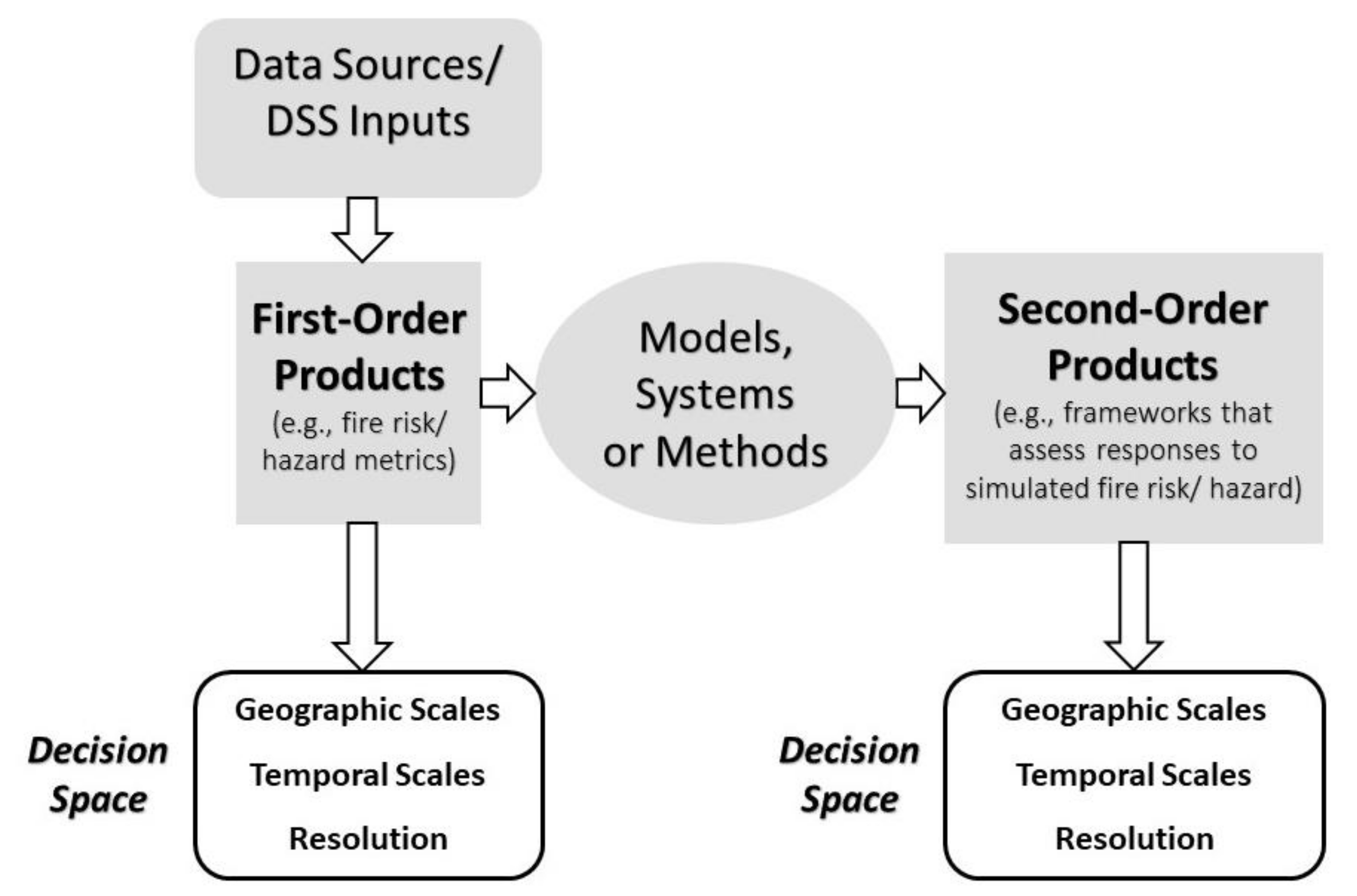
Lastly, many respondents defined DSSs in broad terms. Respondents made distinctions among data, software, and outputs when asked to define DSSs or DSTs. As has been noted, there are many DSSs in use, and those referenced in this paper (Table 4) are not a comprehensive summary (e.g., [11,13]). Nonetheless, due to the confusion about differences in DSSs expressed by respondents, as well as the other barriers identified by respondents, a clear organization of DSSs in a user-oriented framework that could be coupled with the other recommendations may be warranted. Such a framework could be updated as new tools emerge or existing tools evolve, but it is imperative that it be organized in such a way as to facilitate end-user understanding of the different DSSs and where they can be applied in different decision spaces or decision contexts (e.g., long-term, strategic planning; short-term, tactical planning; and scene-of-action decision-making). A framework for organizing DSSs according to the themes from this research is provided in Figure 1. The framework distinguishes between data or DSS inputs, which are processed to create first-order products such as fire probability surfaces that can provide decision support without any further processing. However, the framework also acknowledges that first-order products can be further processed with different models, systems, or analysis methods to produce second-order products that provide an added level of information for decision making (e.g., QWRA or PODs, see Table 4). Both first- and second-order products can be generated at different geographic and temporal scales, as well as resolutions. Each of these different types of outputs has potential use for decision making, but there is a need to better organize them according to the different decision spaces in which they are relevant.
This framework is a proposed path forward for better organizing existing and future DSSs according to the types of decisions their outputs can inform and to better contextualize them for end users. An organization of DSSs could be coupled with the other recommendations from this study to work toward a more efficient use of DSSs to support science-based, collaborative, strategic pre-fire planning that acknowledges a changing paradigm around forest and fire risk management.
Funding
This research was funded by a grant from the United States Department of Agriculture Forest Service.
Data Availability Statement
The interview recordings for this study were deleted after transcription in accordance with the Institutional Review Board (IRB) requirements for this study. The transcripts have been de-identified and are kept in a secure location managed by the author. Data requests will be considered on an as needed basis in accordance with IRB rules. Transcripts for this study will be deleted in 2025 in accordance with IRB rules.
Acknowledgments
I am grateful for the contributions and time of the interview participants whose knowledge and perspectives informed this report. I am also grateful for the time and perspectives of my colleagues in the field who helped in the conceptualization of this study. Northern Arizona University is an equal opportunity provider.
Conflicts of Interest
The author declares no conflict of interest. The funders had no role in the design of the study; in the collection, analyses, or interpretation of data; in the writing of the manuscript, or in the decision to publish the results.
References
- Schoennagel, T.; Balch, J.K.; Brenkert-Smith, H.; Dennison, P.E.; Harvey, B.J.; Krawchuk, M.A.; Mietkiewicz, N.; Morgan, P.; Moritz, M.A.; Rasker, R.; et al. Adapt to more wildfire in western North American forests as climate changes. Proc. Natl. Acad. Sci. USA 2017, 18, 4582–4590. [Google Scholar] [CrossRef] [Green Version]
- Dunn, C.J.; O’Connor, C.D.; Abrams, J.; Thompson, M.P.; Calkin, D.E.; Johnston, J.D.; Stratton, R.; Gilbertson-Day, J. Wildfire risk science facilitates adaptation of fire-prone social-ecological systems to the new fire reality. Environ. Res. Lett. 2019, 15. [Google Scholar] [CrossRef]
- Greiner, S.M.; Schultz, C.A.; Kooistra, C. Pre-season fire management planning: The use of Potential Operational Delineations to prepare for wildland fire events. Int. J. Wildland Fire 2020. [Google Scholar] [CrossRef]
- Stratton, R. The path to strategic wildland fire management planning. Wildfire 2020, 29, 24–31. [Google Scholar]
- Thompson, M.P.; MacGregor, D.G.; Dunn, C.J.; Calkin, D.E.; Phipps, J. Rethinking the wildland fire management system. J. For. 2018, 116, 382–390. [Google Scholar] [CrossRef] [Green Version]
- Wildland Fire Leadership Council. The National Strategy: The Final Phase in the Development of National Cohesive Wildland Fire Management Strategy. 2014; 101p. Available online: https://www.forestsandrangelands.gov/strategy/thestrategy.shtml (accessed on 13 April 2021).
- USDA Forest Service. Forest Service Manual 5100–Wildland Fire Management, Chapter 5140–Hazardous Fuels Management and Prescribed Fire; USDA Forest Service National Headquarters (WO): Washington, DC, USA, 2020; 17p.
- USDA Forest Service. Toward Shared Stewardship Across Landscapes: An Outcome-Based Investment Strategy; USDA Forest Service National Headquarters (WO): Washington, DC, USA, 2018; 28p. Available online: https://www.fs.usda.gov/sites/default/files/toward-shared-stewardship.pdf (accessed on 11 February 2021).
- United States Congress. H.R. 1625 Consolidated Appropriations Act (PL115-141). 2018. Available online: https://www.congress.gov/bill/115th-congress/house-bill/1625/text (accessed on 11 February 2021).
- O’Connor, C.D.; Thompson, M.P.; Rodríguez y Silva, F. Getting ahead of the wildfire problem: Quantifying and mapping management challenges and opportunities. Geosciences 2016, 6, 35. [Google Scholar] [CrossRef] [Green Version]
- Pacheco, A.P.; Claro, J.; Fernandes, P.M.; de Neufville, R.; Oliveira, T.M.; Borges, J.G.; Coelho Rodrigues, J. Cohesive fire management within an uncertain environment: A review of risk handling and decision support systems. For. Ecol. Manag. 2015, 347, 1–17. [Google Scholar] [CrossRef]
- Rapp, C.; Rabung, E.; Wilson, R.; Toman, E. Wildfire decision support tools: An exploratory study of use in the United States. Int. J. Wildland Fire 2020, 29, 581–594. [Google Scholar] [CrossRef]
- Thompson, M.P.; Wei, Y.; Calkin, D.E.; O’Connor, C.D.; Dunn, C.J.; Anderson, N.M.; Hogland, J.S. Risk management and analytics in wildfire response. Curr. For. Rep. 2019, 5, 226–239. [Google Scholar] [CrossRef] [Green Version]
- Thompson, M.P.; Zimmerman, T.; Mindar, D.; Taber, M. Risk Terminology Primer: Basic Principles and a Glossary for the Wildland Fire Management Community; General Technical Report 349; USDA Forest Service, Rocky Mountain Research Station: Ft. Collins, CO, USA, 2016; 19p.
- Esch, B.E.; Waltz, A.E.M.; Wasserman, T.N.; Kalies, E.L. Using best available science information: Determining best and available. J. For. 2018, 116, 473–480. [Google Scholar] [CrossRef] [Green Version]
- Colavito, M.M. Utilising scientific information to support resilient forest and fire management. Int. J. Wildland Fire 2017, 26, 375–383. [Google Scholar] [CrossRef] [Green Version]
- Hunter, M.E. Outcomes of fire research: Is science used? Int. J. Wildland Fire 2016, 25, 495–504. [Google Scholar] [CrossRef] [Green Version]
- Hunter, M.E.; Colavito, M.M.; Wright, V. The use of science in wildland fire management: A review of barriers and facilitators. Curr. For. Rep. 2020, 6, 354–367. [Google Scholar] [CrossRef]
- White, E.M.; Lindberg, K.; Davis, E.J.; Spies, T.A. Use of science and modeling by practitioners in landscape-scale management decisions. J. For. 2019, 117, 267–279. [Google Scholar] [CrossRef] [Green Version]
- Wright, V. Influences to the Success of Fire Science Delivery: Perspectives of Potential Fire/Fuels Science Users; JFSP #04-4-2-01. 2010. Available online: https://www.firescience.gov/projects/04-4-2-01/project/04-4-2-01_vw_jfsp_final_report.pdf (accessed on 13 April 2021).
- Wurtzebach, Z.; Schultz, C.A.; Waltz, A.E.M.; Esch, B.E.; Wasserman, T.N. Adaptive governance and the administrative state: Knowledge management for forest planning in the Western United States. Reg. Environ. Chang. 2019, 19, 2651–2666. [Google Scholar] [CrossRef]
- Timberlake, T.J.; Schultz, C.A.; Evans, A.; Abrams, J.B. Working on institutions while planning for forest resilience: A case study of public land management in the United States. J. Environ. Plan. Manag. 2020, 1–21. [Google Scholar] [CrossRef]
- Calkin, D.C.; Finney, M.A.; Ager, A.A.; Thompson, M.P.; Gebert, K.M. Progress towards and barriers to implementation of a risk framework for US federal wildland fire policy and decision making. For. Policy Econ. 2011, 13, 378–389. [Google Scholar] [CrossRef]
- Calkin, D.E.; Thompson, M.P.; Finney, M.A. Negative consequences of positive feedbacks in US wildfire management. For. Ecosyst. 2015, 2, 1–10. [Google Scholar] [CrossRef] [Green Version]
- Calkin, D.E.; Ager, A.A.; Gilbertson-Day, J. Wildfire Risk and Hazard: Procedures for the First Approximation; General Technical Report RMRS-GTR-235; U.S. Department of Agriculture, Forest Service, Rocky Mountain Research Station: Fort Collins, CO, USA, 2010; 62p.
- Caggiano, M.D. Potential Operational Delineations and Northern New Mexico’s 2019 Fire Season; CFRI-2002; Colorado Forest Restoration Institute: Ft. Collins, CO, USA, 2020; 8p, Available online: https://cfri.colostate.edu/wp-content/uploads/sites/22/2020/02/Caggiano_PODs-New-Mexico-Case-Study-2.14.20.pdf (accessed on 11 February 2021).
- O’Connor, C.D.; Calkin, D.E. Engaging the fire before it starts: A case study from the 2017 Pinal Fire (Arizona). Wildfire 2019, 28, 14–18. [Google Scholar]
- Rodríguez y Silva, F.; O’Connor, C.D.; Thompson, M.P.; Molina Martínez, J.R.; Calkin, D.E. Modelling suppression difficulty: Current and future applications. Int. J. Wildland Fire 2020, 29, 739–751. [Google Scholar] [CrossRef]
- Esch, B.; Waltz, A.E.M. Assessing Metrics of Landscape Restoration Success in Collaborative Forest Landscape Restoration Projects; ERI White Paper–Issues in Forest Restoration; Ecological Restoration Institute, Northern Arizona University: Flagstaff, AZ, USA, 2019; 12p, Available online: https://cdm17192.contentdm.oclc.org/digital/collection/p17192coll1/id/1015/rec/36 (accessed on 11 February 2021).
- Colavito, M.M.; Wasserman, T.N.; Vosick, D. All-Lands Planning, Coordination, and Wildfire Risk Reduction Project Report; Ecological Restoration Institute, Northern Arizona University: Flagstaff, AZ, USA, 2018; 54p, Available online: https://cdm17192.contentdm.oclc.org/digital/collection/p17192coll1/id/913/rec/2/ (accessed on 11 February 2021).
- Schultz, C.A.; Thompson, M.P.; McCaffrey, S.M. Forest Service fire management and the elusiveness of change. Fire Ecol. 2019, 15, 13. [Google Scholar] [CrossRef]
- Noble, P.; Paveglio, T.B. Exploring adoption of the Wildland Fire Decision Support System: End user perspectives. J. For. 2020, 118, 154–171. [Google Scholar] [CrossRef]
- Dunn, K. Interviewing. In Qualitative Research Methods in Human Geography, 2nd ed.; Hay, I., Ed.; Oxford University Press: Melbourne, VIC, Australia, 2008; pp. 79–105. [Google Scholar]
- Bernard, H.R.; Ryan, G. Analyzing Qualitative Data: Systematic Approaches; Sage Publications: Thousand Oaks, CA, USA, 2010; 480p. [Google Scholar]
- Strauss, A.L.; Corbin, J.M. Basics of Qualitative Research: Grounded Theory Procedures and Techniques; Sage Publications: Newbury Park, CA, USA, 1990; 270p. [Google Scholar]
- Saldaña, J. The Coding Manual for Qualitative Researchers; Sage Publications: Thousand Oaks, CA, USA, 2016; 339p. [Google Scholar]
- Schultz, C.A.; Kooistra, C.; Miller, L.; Ferguson, M. Findings from a Third-Party Assessment of the U.S. Forest Service’s Risk Management Assistance Teams; Public Lands Policy Group, Colorado State University: Ft. Collins, CO, USA, 2020; 40p. [Google Scholar]
- Ager, A.A.; Houtman, R.M.; Seli, R.; Day, M.A.; Bailey, J. Integrating large wildfire simulation and forest growth modeling for restoration planning. In Proceedings of the 2017 Forest Vegetation Simulator (FVS) e-Conference; Tech. Rep. SRS-224. Keyser, C.E., Keyser, T.L., Eds.; U.S. Department of Agriculture Forest Service, Southern Research Station: Asheville, NC, USA, 2017; pp. 129–137. [Google Scholar]
- Scott, J.; Thompson, M.P.; Calkin, D.E. A Wildfire Risk Assessment Framework for Land and Resource Management; Gen. Tech. Rep. RMRS-GTR-315; U.S. Department of Agriculture, Forest Service, Rocky Mountain Research Station: Fort Collins, CO, USA, 2013; 83p.
- Rothermel, R.C. A Mathematical Model for Predicting Fire Spread in Wildland Fuels; USDA Forest Service Research Paper INT-115; U.S. Department of Agriculture, Intermountain Forest and Range Experiment Station: Ogden, UT, USA, 1972; 40p.
- Caggiano, M.D. Collaboratively Engaging Stakeholders to Develop Potential Operational Delineations; CFRI-1908; Colorado Forest Restoration Institute: Ft. Collins, CO, USA, 2019; 10p, Available online: https://cfri.colostate.edu/wp-content/uploads/sites/22/2019/08/PODs-Collaborative-Engagement-Final-Report.pdf (accessed on 11 February 2021).
- Ager, A.A.; Houtman, R.M.; Day, M.A.; Ringo, C.; Palaiologou, P. Tradeoffs between US National Forest harvest targets and fuel management to reduce wildfire transmission to the wildland urban interface. For. Ecol. Manag. 2019, 434, 99–109. [Google Scholar] [CrossRef]
- Bremer, S.; Meisch, S. Co-production in climate change research: Reviewing different perspectives. Wiley Interdiscip. Rev. Clim. Chang. 2017, 8, e482. [Google Scholar] [CrossRef]
- Cash, D.W.; Clark, W.C.; Alcock, F.; Dickson, N.M.; Eckley, N.; Guston, D.H.; Jager, J.; Mitchell, R.B. Knowledge systems for sustainable development. Proc. Natl. Acad. Sci. USA 2003, 100, 8086–8091. [Google Scholar] [CrossRef] [PubMed] [Green Version]
- McNie, E.C. Delivering climate services: Organizational strategies and approaches for producing useful climate-science information. Weather Soc. 2013, 5, 14–26. [Google Scholar] [CrossRef]
- Meadow, A.M.; Ferguson, D.C.; Guido, Z.; Horangic, A.; Owen, G.; Wall, T. Moving toward the deliberate coproduction of climate science knowledge. Weather Soc. 2015, 7, 179–191. [Google Scholar] [CrossRef] [Green Version]
- Colavito, M.M.; Trainor, S.F.; Kettle, N.P.; York, A. Making the transition from science delivery to knowledge coproduction in boundary spanning: A case study of the Alaska Fire Science Consortium. Weather Soc. 2019, 11, 917–934. [Google Scholar] [CrossRef]
Figure 1.
A framework for organizing spatial, pre-fire planning DSSs to support end-user understanding and use of tools. Decision space (white boxes) refers to different decision contexts such as long-term, strategic planning; short-term, tactical planning; and scene-of-action decision-making.
Figure 1.
A framework for organizing spatial, pre-fire planning DSSs to support end-user understanding and use of tools. Decision space (white boxes) refers to different decision contexts such as long-term, strategic planning; short-term, tactical planning; and scene-of-action decision-making.


Table 1.
Key concepts and their associated definitions as used in this paper.
| Key Concept | Definition |
|---|---|
| Decision Support System | Different frameworks, models, analysis methods, products, and tools (i.e., software) that provide information about wildfire risk assessment and treatment prioritization to support pre-fire planning. DSS refers to specific tools, such as the Wildfire Decision Support System (WFDSS), as well as analysis methods and frameworks, such as Quantitative Wildfire Risk Assessments (QWRA) or Potential Operational Delineations (PODs). |
| Wildfire Risk Assessment | Approaches for assigning values to risks or benefits from fire to support decision making. The Thompson et al. [13] definition is used, “A product or process that collects information and assigns values (relative, qualitative, quantitative) to risks for the purpose of informing priorities, developing or comparing courses of action, and informing decision making.” |
| Treatment Prioritization | Approaches for determining where to treat hazardous fuels to reduce wildfire risk as determined by a wildfire risk assessment or other ranking process. |
Table 2.
Interviewee general classifications (as assigned or self-identified during interview). Scientist/developer refers to interviewees who primarily conduct research and may work in the Forest Service or external organization. Boundary spanner refers to interviewees who work to facilitate connections between scientists/developers and managers; they worked in both the Forest Service and partner institutions such as universities. Boundary spanners in the context of pre-fire planning in the U.S. are individuals who provide communication and translation functions that help to facilitate the exchange of knowledge to co-develop DSSs and bridge the spheres of science and management. Manager refers to interviewees who make fire or forest management decisions and work for the Forest Service.
| Interviewee Classification | Number of Interviewees | Percent of Interviewees |
|---|---|---|
| Scientist/Developer | 6 | 22% |
| Boundary Spanner | 8 | 30% |
| Manager | 13 | 48% |
Table 3.
Interviewee demographics by job role.
| Job Role | Number of Interviewees | Percent of Interviewees |
|---|---|---|
| Collaborative Partner | 2 | 7.3% |
| Agency Researcher | 2 | 7.3% |
| Line Officer | 2 | 7.3% |
| External Researcher | 3 | 11% |
| Fuels Management | 5 | 19% |
| Fire Management | 6 | 22% |
| Agency Analysis/Technical Transfer | 7 | 26% |
Table 4.
DSS types and DSSs referenced by interviewees; not a comprehensive list of DSSs for wildfire risk assessment and treatment prioritization planning. Websites where these DSSs can be accessed are provided where available.
Table 4.
DSS types and DSSs referenced by interviewees; not a comprehensive list of DSSs for wildfire risk assessment and treatment prioritization planning. Websites where these DSSs can be accessed are provided where available.
| DSS Type | DSSs Referenced by Interviewees | Website (All Sites Accessed 8 April 2021) |
|---|---|---|
| Data Sources/DSS Inputs | LANDFIRE: a database of more than 20 geospatial layers such as vegetation, fire regimes, and fuels for the United States. | landfire.gov |
| Field Sampled Vegetation (FSVeg): stores data about trees, fuels, down woody material, surface cover, and understory vegetation. | https://www.fs.fed.us/nrm/fsveg/ | |
| Forest Inventory and Analysis (FIA): a nationally coordinated inventory of U.S. forest data. | https://www.fia.fs.fed.us/ | |
| Wildfire Risk Probability Simulators/Models | FlamMap: a fire analysis system that calculates pixel-based measures of fire behavior; smaller scale but similar to LFSim. | https://www.firelab.org/project/flammap |
| FARSITE: a computational approach to estimating wildfire growth and behavior integrated in FlamMap. | https://www.firelab.org/project/farsite | |
| Large Fire Modeling Simulation System (FSim or LFSim): a method for simulating fire across larger scales and across seasons than FlamMap or FARSITE but using similar parameters. | https://www.firelab.org/project/fsim-wildfire-risk-simulation-software | |
| Fire Spread Probability (FSPro): a probabilistic model that estimates where fire may go. Only available within the Wildland Fire Decision Support System. | https://wfdss.usgs.gov/wfdss_help/3290.htm | |
| BEHAVE: a fire modeling system that simulates surface and crown fire rate of spread and intensity, ignition probability, fire size, spotting, and mortality. | https://www.firelab.org/project/behaveplus | |
| Methods or Products that Use Wildfire Risk Simulations | Wildfire Hazard Potential: a national map that combines flame-length and burn probability estimates across large landscapes. | https://www.firelab.org/project/wildfire-hazard-potential https://wildfirerisk.org/ https://wfdss.usgs.gov/wfdss/WFDSS_Home.shtml |
| Wildfire Risk to Communities: an interactive website that provides a national scale assessment of wildfire risk among communities, created in response to a 2018 law (PL115-141) [9] requiring the Forest Service to map hazards by community. | ||
| Wildland Fire Decision Support System (WFDSS): system that supports fire managers, agency administrators, and analysts in making decisions on fires; includes fire modeling capability and decision documentation processes. | ||
| Quantitative Wildfire Risk Assessment (QWRA): a fire modeling process that assesses how highly valued resources and assets respond to modeled fire behavior and determines associated benefits and threats [25,39]. | ||
| Potential Operational Delineation (POD): Boundaries or polygons that provide different fire response options across a landscape and an overview of fire risk according to potential control features and values at risk [3,26,41]. | ||
| Wildfire Hazard Assessment Approaches, Models, and Tools | Forest Vegetation Simulator (FVS): forest vegetation modeling tool that simulates forest growth in response to natural processes and management actions. | https://www.fs.fed.us/fvs/ |
| LSim: a forest landscape simulation model integrating FSim into a modified FVS Parallel Processing Extension [38]. | ||
| Scenario Investment Planning Platform (SIPP): spatial scenario planning model (FORSYS), formerly Landscape Treatment Designer (LTD), scenario planning approach for resource allocation and budgeting [42]. | https://sipp-usfs.opendata.arcgis.com/ | |
| ArcFuels: ArcGIS extension that uses FVS and fire behavior models to inform fuel treatment planning, fire behavior modeling, and wildfire risk assessment. | https://www.fs.fed.us/wwetac/tools/arcfuels/index.php | |
| Interagency Fuel Treatment Decision Support System (IFTDSS): online system for fuels treatment planning, including fire behavior modeling for testing fuels treatment impacts on fire behavior to determine priority treatment areas. | https://iftdss.firenet.gov/ |
Table 5.
Key themes from results on DSS barriers, facilitators, and recommendations.
| Results | Themes |
|---|---|
| DSS Barriers | (1) Persistent tensions, disconnects, and cultural issues impact the use of DSSs; |
| (2) Capacity issues inhibit both the development and use of DSSs; | |
| (3) An ineffective process to integrate a new DSS into a program of work can limit its outcomes; | |
| (4) Technical challenges in the use of DSSs can impact perceptions of their accuracy and usability; | |
| (5) Complex information in DSSs can be difficult to understand and can lead to confusion and information overload; | |
| (6) Institutional issues and governance barriers can inhibit the use of DSS; and | |
| (7) Strategies for integrating DSS outputs into decision making processes are often lacking. | |
| DSS Facilitators | (1) DSSs spur new conversations and facilitate communication; |
| (2) The process of developing and using DSSs impacts their perceived effectiveness; and | |
| (3) DSSs can enhance the legitimacy of decisions. | |
| DSS Recommendations | (1) Analytical capacity and funding to develop, integrate, and use DSSs needs to be increased; |
| (2) Communication about DSSs must be done in a common language and sustained through time to build relationships; | |
| (3) Implementation planning can ensure that DSS outputs are used; | |
| (4) Determine the question that a DSS is meant to inform and develop and/or apply it accordingly; | |
| (5) DSSs should be validated and tested with end users; | |
| (6) DSS end users need both education and training in the concepts and tools; and | |
| (7) Leadership intent for integrating and using DSSs should be clearly articulated through policies, guidance, and authorities. |
Publisher’s Note: MDPI stays neutral with regard to jurisdictional claims in published maps and institutional affiliations. |
© 2021 by the author. Licensee MDPI, Basel, Switzerland. This article is an open access article distributed under the terms and conditions of the Creative Commons Attribution (CC BY) license (https://creativecommons.org/licenses/by/4.0/).
Share and Cite
MDPI and ACS Style
Colavito, M. The Human Dimensions of Spatial, Pre-Wildfire Planning Decision Support Systems: A Review of Barriers, Facilitators, and Recommendations. Forests 2021, 12, 483. https://0-doi-org.brum.beds.ac.uk/10.3390/f12040483
AMA Style
Colavito M. The Human Dimensions of Spatial, Pre-Wildfire Planning Decision Support Systems: A Review of Barriers, Facilitators, and Recommendations. Forests. 2021; 12(4):483. https://0-doi-org.brum.beds.ac.uk/10.3390/f12040483
Chicago/Turabian StyleColavito, Melanie. 2021. "The Human Dimensions of Spatial, Pre-Wildfire Planning Decision Support Systems: A Review of Barriers, Facilitators, and Recommendations" Forests 12, no. 4: 483. https://0-doi-org.brum.beds.ac.uk/10.3390/f12040483
Note that from the first issue of 2016, this journal uses article numbers instead of page numbers. See further details here.