Article

Policy and Planning Challenges to Promote Efficient Urban Spatial Development during the Emerging Rapid Transformation in China

National Center for Smart Growth, The University of Maryland, 1112L Preinkert House Building, 054 College Park, MD, USA
Sustainability 2009, 1(3), 384-408; https://0-doi-org.brum.beds.ac.uk/10.3390/su1030384
Submission received: 16 June 2009 / Accepted: 31 July 2009 / Published: 3 August 2009
(This article belongs to the Special Issue Advanced Forum for Sustainable Development)

Abstract

:
This paper investigates the linkage between emerging urban spatial development and institutional arrangements in China. Emerging spatial patterns, which are prevalent and sizable so that any impacts will be substantial, include dispersed employment concentration, fragmented land development, over-scaled land development, leapfrogging development, and whack-a-mole development. From the institutional point of view, these patterns are associated with decentralization, fiscal incentives for local government, land regulations, and fragmented planning system. It is concluded that these emerging spatial patterns significantly affect long term city sustainable growth and comprehensive reforms are needed to promote efficient urban spatial forms. It is further concluded that labor division between planning and markets should be reshaped in determining urban spatial growth by shifting planning to focus on zoning that provides sufficient development room in a long term and making markets to decide the timing of land development.

1. Introduction

Urban form and spatial structure are of interest to economists, urban planners, transportation engineers, environmentalists, and geographers since they are directly and indirectly associated with land and capital allocations and utilizations, urban agglomerative economy, transportation demand, energy usage, environmental impact, and many other urban issues and problems such as traffic congestion [1,2,3]. Efficient utilization of land resources requires changes in the intensity of land use with respect to land prices while a certain degree of substitution of land to capital is needed to ensure optimal inputs of land and structure for profit maximization in housing production [4,5,6,7].
An efficient spatial structure facilitates labor pooling, reducing average manufacturing costs, and promotes spillovers in technology and management. Clustering employment and non-residential activities increases the average travel distance and time and are constructive in the creation, transfer and usage of knowledge [8,9,10]. The size and level of concentration of population and workers increases the chance for face-to-face contact, which “is an efficient communication technology, can help solve incentive problems, can facilitate socialization and learning, and provides psychological motivation” [11]. Through face-to-face contact facilitation, clustering of firms and workers increases localized interactions that promote technological innovation. Face-to-face contact also plays important roles in business development and social networking. Therefore, cities are hubs for innovation in the production of ideas and knowledge and in their commercialization [12].
An efficient urban spatial form is cost effective in infrastructure provision through coordination with land uses (such as land use and transportation integration). It can also enhance local governments’ fiscal and finance efficiency, which can be improved by arranging urban spatial patterns in ways in which preferences for the public good are homogenous, free-riders for public goods are reduced or eliminated, and private benefits and public costs of public goods and services are equalized [13,14].
An efficient urban spatial form has minimum land use externality via a separation of incompatible land uses [14,15,16,17]. Finally, an efficient spatial structure increases quality of life and promotes preservation of open space, farmland, and urban environment, which helps to increase a city’s competitiveness and attractiveness. In a sum, an efficient urban spatial pattern can accommodate urban growth while concurrently reducing or minimizing unwanted consequences.
Urban spatial structure is constantly evolving, reflecting accumulated decisions on land improvement, economic development, provision of urban infrastructure, institutional arrangements on fiscal and tax policy, as well as planning regulations. Urban spatial structure is thus a physical outcome of regulation, taxation, planning, and land markets upon the terrain constraints and topography of a city [18]. The complexity of urban areas and marginal changes of built areas are perhaps two primary reasons for the under documentation in the literature in linking city landscape to urban policy.
Both the speed and scale of urban development in Chinese cities, particularly along the eastern coast, have been taking place at an unprecedented pace and scale. The rapid urban spatial encroachment into rural areas has been driven by enormous economic growth for business development and by a strong individual desire for a better quality of life (measured by housing consumption, infrastructure improvement, increased transportation accessibility, and the building and preserving of urban green space) [19,20,21]. The remarkable urban spatial developments in Chinese cities do not occur without great costs and unwanted consequences, reflected in environmental deterioration, open space destruction, rising urban-rural tension, increased transportation expenses, chaotic urban spatial encroachment and sprawl. This paper will then focus on two fundamental questions: 1) during the rapid transition period, what are the emerging urban spatial development patterns that have substantial long term efficiency or cost implications and affect sustainable growth trajectories that reduce a city’s productivity and competitiveness; 2) are there any policies directly or indirectly responsible for the creation and development of these inefficient urban spatial patterns? In other words, what are institutional factors behind the emerging inefficient urban development patterns?
Urban spatial structures are complex, path-dependent, resilient, and slow to change. It is difficult, if not impossible, to analyze them, particularly with respect to policy changes. Rapid urban spatial expansion and dramatic changes in institutions governing resource mobility in China throughout the past three decades may provide a rare opportunity to investigate the interaction between urban spatial developments and policies. Dramatic movement towards a market economy from a planned one has greatly changed incentives of economic agents and increased mobility of labor, capital and land inputs.
Systematic and quantitative analyses of urban spatial structure and their association with policy and institutional changes require extensive data at both the micro- and macro-levels for measurement as well as in time series for possible causality examination. This kind of data, however, rarely exists. This paper hence takes a different approach to speculate about the possible connection between urban spatial development and policy and institutional settings. Instead of cross-section data examination or case studies on typical regions/areas, this paper analyzes urban spatial development patterns that are representative and widespread in many Chinese cities based on reasoning rational behaviors of players/agents and incentive structures behind land development. Sound investigation of causality between urban spatial development and policy and institutional arrangement is not a primary objective for this paper. Rather, this paper attempts to shed insight onto connections and interactions.
The remainder of the paper proceeds as follows: Section 2 discusses land use and development in the pre-reform period, followed by the examination of land development in the post-reform period. Section 4 focuses on emerging urban spatial forms while Section 5 reasons factors behind inefficient urban spatial patterns. Section 6 concludes the paper with a few final remarks.

2. Land Use and Development in the Pre-Reform Period

Both urban spatial development and the institutional arrangements for land use and development should be examined in a historical context because of resiliency and path-dependency of city shape. In the pre-reform period, the spatial structure of Chinese cities looked similar and had distinctive features of “uniform and standardized landscapes of mixed industrial and residential compounds” [22, p. 30]. These compounds, which were often separated from others via walls, served multiple functions such as workplaces, residential space, playgrounds, and social services such as kindergartens and shops. Those highly mixed land use compounds suited prevailing transportation modes (pedestrian and bicycles) well and became one of the dominant urban patterns in China. The widespread distribution of those mixed land use compounds in the city produced the so-called cellular urban fabric structure, which was integrated at a micro-level but became chaotic at a macro-level.
Highly mixed land use patterns have two spatial implications. One is associated with the flat employment density curve. Unlike monocentric cities with steep employment density curves (jobs, particularly non-manufacturing jobs, tend to concentrate in central locations), mixed land use patterns spread jobs out over a city and createed flat employment distribution and density curves in Chinese cities [23]. In contrast, westernized cities (i.e., New York, Tokyo, Seoul, Washington DC, and Chicago) have steep employment density curves, largely attributable to the presence of their Central Business Districts (CBDs). New York and San Francisco, for instance, have 45-50 percent of its total employment rate located within a 3 mile ring around their CBD respectively. The average employment density within 0–5 mile from the CBD, for instance, is 24,000 persons per square mile, which is much higher than average population density of 7,700 person per square mile across American cities.
The other implication is related to spatial traffic patterns. Highly mixed land use patterns generate traffic flows that point to all directions in the two dimensional space. Traffic jams resulting from chaotic and unorganized traffic spatial flows slow down traffic and create mental stress for drivers. Co-existence of multi-modes (walking, bicycling, automobiles, and buses) further substantially amplifies traffic jams (Figure 1).
Figure 1. Traffic jam in Beijing.
Sustainability 01 00384 g001
Many residential lots are found in the middle of farm fields, creating a very fragmented land use patterns in China rural areas (Figure 2). Like many other agrarian countries, intermingling of farmland and residential lots are due to low scale operation in agricultural economy and non-motorcycle dominance of transportation. What makes land use patterns in China’s rural areas more distinctive, however, is the degree to which residential lots and farmland are intermingled together, largely resulting from low capita cultivated land occupation, particularly in eastern coastal areas. Per capital cultivated land occupation in Zhejiang and Jiangsu provinces, for instance, were 0.54 mu and 1.03 mu, respectively, in 2000 (mu is area unit of 1/15 hectare). Since both provinces have high urbanization rates, actual cultivated land occupation per peasant is around 1.5–3 mu. I think there are few other places that are more fragmented than in eastern coastal China (Figure 2).

3. Land Development in Post-Reform Era

Rapid industrialization and economic growth have caused Chinese cities to grow at unprecedented rates. The number of cities, sizes, and built-up areas has increased remarkably [20]. The built-up areas for cities and towns increased from 7,438 square kilometer in 1981 to 25,927.6 square kilometer in 2002. Not all cities and towns have grown proportionally. Larger and more developed cities expand more quickly. The share of built-up areas by prefecture cities over total built-up areas increased from 68.56 percent in 1998 to 76.4 percent in 2002, for example.
Figure 2. Residential development in the rural Yangtze Delta.
Sustainability 01 00384 g002
Remarkable urban spatial expansion is both a cause and effect of rapid economic growth [24,25]. This is particularly true for big cities (here big cities are defined by administrative status, for instance, prefecture vs. county cities rather than by population size). The share of GDP produced by prefecture cities over total national GDP rose from 36 percent in 1990 to 63 percent in 2007. The secondary industry’s GDP produced by prefecture cities was 259.4 billion and accounted for 47 percent of total GDP in that sector. These numbers increased to $946.1 billion and 65.07 percent in 2006, respectively.
The development of the secondary industry is attributed largely to various industrial parks and economic development districts that greatly benefit from tax incentives and special financial treatment. By 2004, there were 6,866 industrial parks and economic zones on land covering 34,800 square kilometers, which exceeded total urban built-up areas. Many of these parks or districts are home to rapidly surging FDI and other fixed capital investments.
Massive fixed capital investments, particularly in real estate and housing industries, are one of main engineers for pronounced land development. The real estate investments in housing development by developers grew from nothing to $111.2 in 2007 (total real estate investments in housing development exclude investments by individuals). Accordingly, the completed building construction increased from 14.79 million square meters in 1981 to 48.82 million. Massive investments in housing have resulted in much improved housing conditions. The per capita housing consumption in cities and towns increased from 6.7 square meters in 1978 to 28 square meters in 2007.
The magnitude of land development in China is manifested in the growth of amount of land leased to developers through the so-called land use rights system. There were only 15.7 ha of leased land in its initial year of 1987, but the total amount of leased land increased to 0.415 million hectares, generating leasing revenues of nearly $160 billion in 2003. Land revenues, which were extra-budgetary incomes for sub-national governments until 2007 and accounted for 20–40 percent for total government expenditures, were primarily used to finance infrastructure for urban expansions and services [26].

4. Emerging Urban Spatial Patterns in Post-Reform Era

Enormous urban spatial expansion did not take place without huge potential costs in terms of optimal urban form and city shape. This section focuses on emerging land use development patterns and their primary assessments.

4.1. Dispersed Employment Concentrations

The growth of Special Economic Zones (SEZs) has been a key in the successful advancement of the Chinese economy. SEZs take various forms such as: 1) high-tech industrial parks; 2) economic and technological development districts; 3) free-trade zones; 4) export-process zones; and 5) others, such as science-based industrial parks. Rapid growth in international trade and surging FDI, along with other fixed capital investments makes these zones and parks (at least some of them) vital to the performance of the national economy. Streamlined government administration and financial and tax incentives encourage businesses and investments.
Each SEZ is a large-scale land development project and home to hundreds of thousands of jobs. A survey of 54 national SEZs in 2005 revealed that the average employment density was slightly over 7,000 jobs per square kilometer (one should be cautious when interpreting the employment density in SEZs for three reasons: 1) many zones are in the process of development; 2) 30–35 percent of land is mandated for green and open space; and 3) an underreporting of employment number because of high rate of turnaround and short job tenure for floating population and temporary workers). Some zones, like the Hongqian development zone in Shanghai, have an employment density of more than 20,000 jobs per square kilometer. The Shenzhen development zone in 2005 provided more than 422,500 employment opportunities in land of 70 square kilometers.
SEZs are developed at the urban fringe areas in a dispersed way, creating many satellite type towns, even in small or medium sized cities. For instance, Langfang located between Beijing and Tianjin is a city of slightly over 4 million on a territory of 6,429 square kilometers (the urban population was around 400,000 in its central built-up areas). Its administrative areas include the city proper and eight districts and each of them has one provincial level SEZ. The city proper has two spatially separated SEZs: one is Langfang SEZ and other is Longhe SEZ. In 2005, more than 5,000 hectares of land development in these SEZs were completed and they contributed 35.1 percent and 45.5 percent to total GDP and fiscal revenues, respectively. Economic success has driven SEZs to expand their land to 208.6 square kilometers.
This kind of dispersed SEZs is common across Chinese cities. Kunshan, located between Shanghai and Suzhou, is one such medium-sized city with a population of 600,000 with Kunshan Hukou in 2007. Figure 3 illustrates that twelve SEZs spread over the entire 921 square kilometers of Kunshan territory provide jobs for a floating population of 1.4 million that worked as nongmingong (so-called rural migrant workers) in 2007. Lack of skills, nongmingong most often end up with low paid jobs and their shelter needs are accommodated through workplace housing, rental housing, or enclaves around their workplaces [27]. Each SEZ thus emerges as spatial development node or nucleus in which jobs and housing are balanced but there is little integration of labor markets in the city. The dispersal of SEZs decreases labor mobility and negatively affects agglomeration economies in production, labor pooling, and spillover effects.
There is little dispute about the importance and contribution of industrial parks and zones to economic growth, particularly for manufacturing. There are, however, disputes about the spatial arrangements of these parks and zones. The issue of concern is associated with dispersed distribution of these parks and zones within a city, which creates many spatially separated employment sub-centers. This dispersed SEZs development inevitably reduces employment concentration and will negatively affect urban agglomeration effects.
Dispersed employment development reduces employment density that is positively corrected with urban agglomeration effects. Empirical studies suggest that urban density is an important determinant of increasing economic returns to scale which facilitates the growth of a city due to positive feedback. A study by Ciccone and Hall [28] provides empirical evidence on the connection between urban density and labor productivity. They conclude that doubling of employment density in a county will increase average labor productivity by six percent. Furthermore, empirical studies also find that the concentration of employment is correlated with high employment opportunity and that there is strong association between industrial concentration and industrial outputs [29]. A study by Sedgley and Elmslie [30] found that population density has a positive and significant relationship with the extent of innovation.
Dispersed development of SEZs may also have substantial implications for housing-job balance, particularly for low-income rural-urban migrants [31,32]. Workplace housing provides temporary solutions for nongmingong but alternative housing options should be sought to better serve the needs of the enormous number of rural-urban migrants projected during rapid urbanization and industrialization in the future. Job accessibility, urban service provision, and affordable housing for these low-income individuals and households will be among the top issues that would be better addressed in large, comprehensive and heterogeneous job markets such as in metropolitan areas rather than in satellite towns.
Finally, the impact of dispersed SEZs on urban transportation should not be overlooked. Although both theory and empirical studies provide mixed results with regard to the connection between urban transport demand and job decentralization [33,34,35], dispersed employment concentration may not likely help to reduce travel time and distance in China. This is partly because two-income households account for a large percentage of total households in Chinese cities and partly because of both low job mobility and low residential mobility [36,37,38]. It should be noticed that although urban transaction costs such as congestion increases with urban agglomeration, the continuous growth of many large metropolitan areas (such as New York and Tokyo) suggests that positive impacts of urban agglomeration exceed negative consequences [5].
Figure 3. Land use (left) and locations of various zones (right) in Kunshan city.
Sustainability 01 00384 g003
Note:
A: Kunshan economic and technology development district;  B: Wujiang Industrial Park
C: Zhouzhuang Science Park;     D: Export Industrial Zone (A and B)
E: Chengbei High Tech Park;      F: Enterprise Development Zone for Overseas Scholars
G: Huaqiao International Commercial District;
H: Northern Industrial Zone;       I: University Park
J: Bacheng Software Park;        K: Huayang Industrial Park
M: Jingban Industrial Park

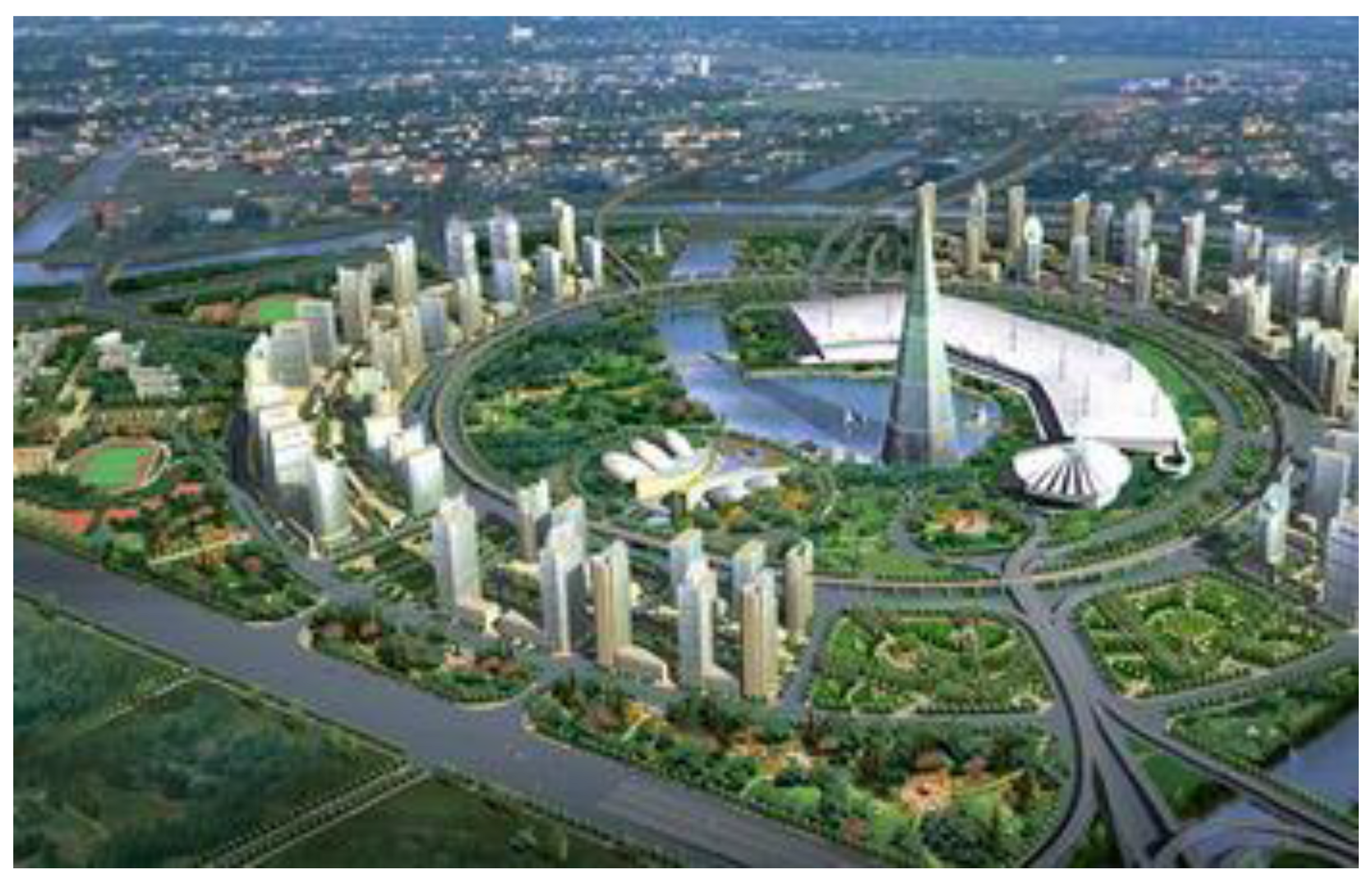
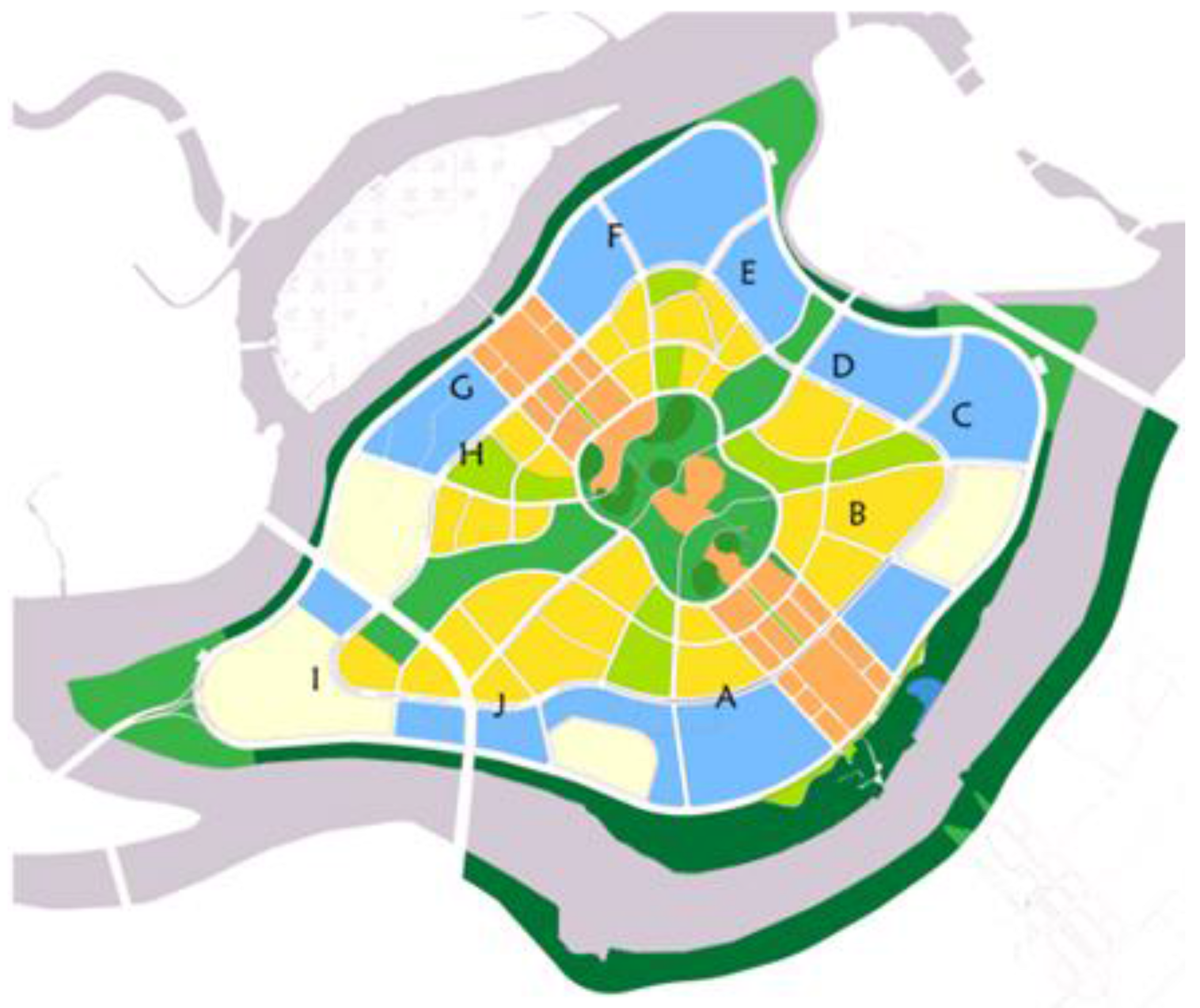
4.2. Fragmented CBD Development

A CBD is distinguished by high employment concentration, commercial and retail oriented activities, skyscrapers, and high traffic congestion. In 2001, the employment density in New York’s Manhattan was more than 238,000 jobs per square kilometer, while Tokyo’s three inner wards are treated as one of its CBDs in which 2,434,200 jobs are offered on an area of 42.2 square kilometers, yielding an average employment density of 57,683 jobs per square kilometer (source: http://www.demographia.com/db-intlcbddensa.htm).
Another striking physical feature that makes a CBD stand out in the city landscape is the clustering of commercial skyscrapers. The average FAR in the core of Seoul CBD is over 10 while the rest of the CBD and sub-centers have a FAR of 8. Land development for residential uses, has FAR values ranging between 0.5 and 4, much lower than those in Seoul CBD and other sub-centers. The FAR in Singapore’s CBD ranges from 8–25, much higher than residential FAR that ranges from 1.5–4 (residential FAR close to the CBD may be up to 6). New York’s Middle Town has 14.63 FAR, on average. The striking contrast between the CBD’s commercial development and other predominantly residential uses is similar in many other cities. Both physical profile and FAR values suggest that commercial buildings in CBDs have much higher values of FAR than that of residential structures outside the CBDs. Land use efficiency would be achieved if high-value added activities occupy central location where land prices are much higher than adjacent areas.
This leads to the determination of what land uses belong to CBD and what land uses do not. According to Murphy [39], non-CBD land uses include: 1) permanent residences (including apartment buildings and rooming houses); 2) government and public property (including parks and public schools as well as establishments carrying out administrative functions); 3) organization establishments (churches, colleges etc.); 4) industrial establishments (except newspapers); 5) wholesaling and commercial storage; 6) railroads and switching yards, and 7) vacant buildings and lots. According to both urban theory as well as Murphy, the presence of these types of land uses in CBDs would certainly reduce land use efficiency.
CBDs are also characterized by high building density. The mid-town CBD in New York’s Manhattan, for instance, has 36 lots on an area of 35.26 hectares. The average building density is 85.89 percent (the maximum value is 100 percent while the minimum value is 63 percent).
Since 1990s, many large cities (with populations exceeding 1 million) in China began to construct new CBDs. By 2002, 36 cities (such as Beijing, Shanghai, Guangzhou, Shenzhen, Zhengzhou, etc.) had planned or established a new CBD. As the economy continues to grow and living standards rise, non-manufacturing jobs become increasingly important. Therefore, building CBDs for non-manufacturing jobs such as commercial, retail, service (e.g., finance and banking sectors) to be concentrated in compact and dense geographic areas is a vital development strategy.
However, the ways in which CBDs are developed suggest that the urban form would not serve strong economic hubs well. Figure 4 illustrates a new planned CBD in Zhengzhou, capital of China’s Henan Province. At the heart of the new CBD is a man-made water pool adjacent to a convention center. High-rise residential and commercial buildings are constructed around the convention center. Lower Residential buildings (80 meter height) are sited inner ring whereas taller commercial buildings (120 meter height) are in outer ring. Residential apartment with much lower density are built further out, separated by green space and highways or main roads.
Unlike western cities, CBDs in China have low land use intensity manifested in low FARs and low building density [40]. For instance, Beijing’s CBD (located in Chaoyang district) was planned in 2001 on an area of 3.99 square kilometers. The average building density (the ratio of land used for building over total land in each lot) is 32.81 percent and average FAR is 5.3 for seven different land uses (commercial, mixed use, residential, school, cultural and recreational, public infrastructure, and open/green space). As expected, land use intensity varies significantly between types, as expected. Commercial use has the highest FAR of 5.67, followed by mixed use with 3.95 FAR and residential use with 3.5 FAR. Other types have FARs that range from 0.5 to 2. The variation of building density between land uses is quite small. School uses have the lowest building density of 20 percent while cultural and recreational uses have the highest value of 40 percent. These general features of low building density, high portion of green space in each lot as well as in the entire CBD areas, and presence of low value added land use types such as school and public utility in Beijing’s CBD are widely shared by CBDs in other Chinese cities.
Figure 4. Zhengzhou new CBD.

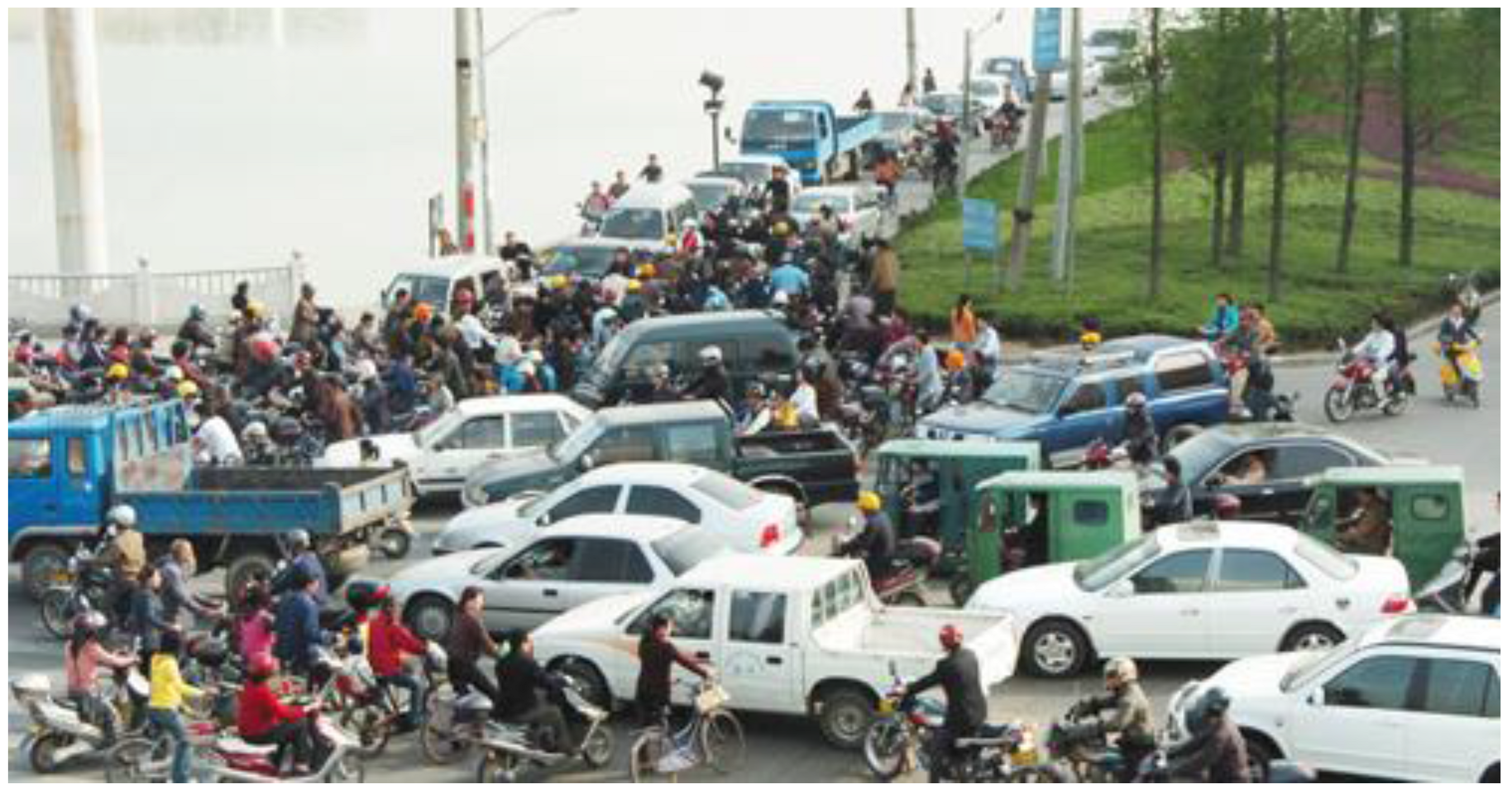
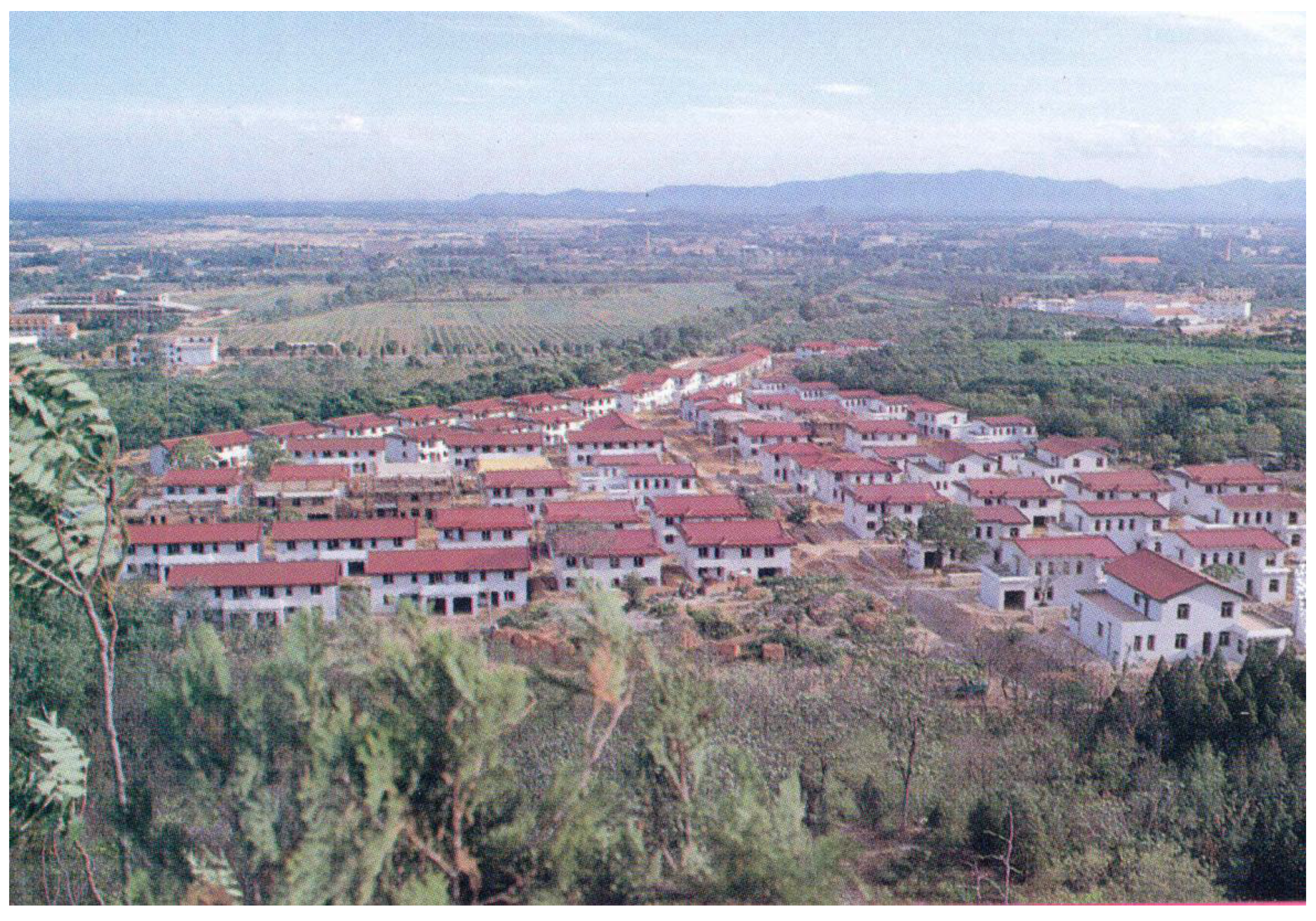
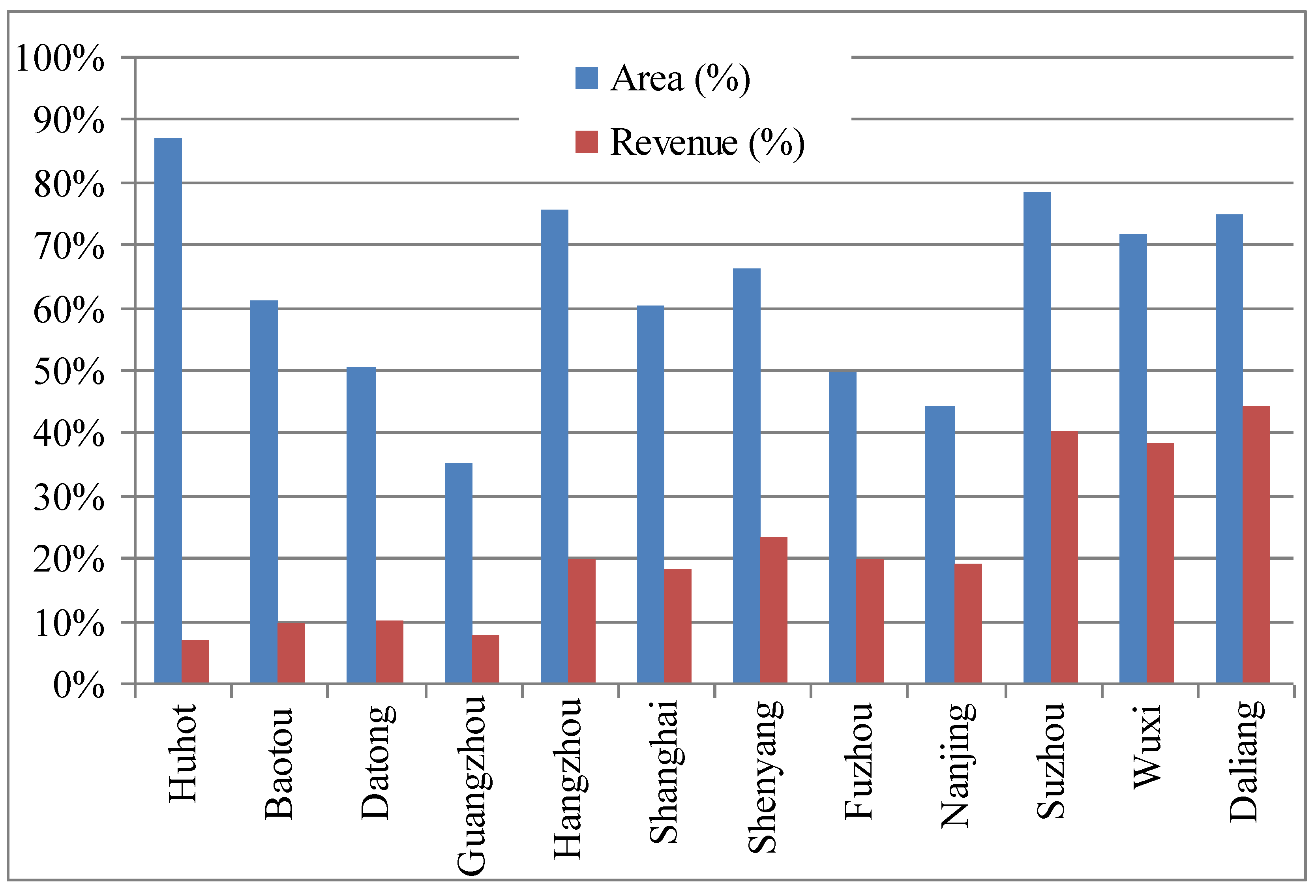
4.3. Over Scaled Land Development

Increasing scale renders positive social welfare as long as marginal benefits exceed marginal costs. Increasing rate in production costs will eventually exterminate any positive gains from increases in scale so that optimal operation exists for profit maximization. This general U-shape cost function is also applicable for land development.
The development of University Towns is one of the most striking urban spatial developments in terms of scale, driven partly by rapid increases in enrollment of higher education institutes and partly by the national policy to promote a knowledge-based economy. By the beginning of this decade, over 50 university towns have been developed across the country. Each is a large scale land development initiative accommodating multiple universities clustered in a concentrated geographic region. For instance, Shahe University Town in Beijing is developed to host 36 colleges and Yuelushan University in Changshai is home to 13 universities. There are 14 universities at Xiasha University Campus in Hangzhou. There are 50 university towns across the country and many of them are still under development [40].
Issues and problems can be better illustrated through a typical examination of a University Town. Guangzhou, for example, created a so-called “University Town” in its Panyu district in 2001. The Town, located about 17 kilometers away from the city center, was planned on 43.3 square kilometers of land with a targeted enrollment of 300,000–350,000 students [41]. Its completion involved multi-phases of construction. The first phrase was the construction of Xiaoguwei Island of 18 square kilometers on which ten different universities are housed. Constructed in a ring pattern, the heart of the campus is home to a centralized and shared physical recreation facility, surrounded by student dormitories along the middle ring, and then by classrooms, libraries, offices and other administrative functions along the outermost ring (Figure 5).
The preliminary assessment of University Towns indicates three main issues [40,41]. First, clustering of universities may help to build inter-university connections and intellectual resource sharing but create physical barriers for intra-university communication. This is because the majority of universities relocate some colleges and programs into newly established universities towns while their central administrative units and other colleges remain on old campuses. Shenzhen University Town has only graduate programs for several colleges while Zhejiang University has moved undergraduates into Zijingang University Town. There is no evidence that inter-campus collaboration has more value-added compared to intra-campus linkages. Therefore, opportunity costs of physical separation within universities may well exceed any gains from clustering different universities.
Figure 5. Guangzhou university town.
Sustainability 01 00384 g005
Light Blue = Institutional;        Yellow = Student Dormitory
Bark Green = Open Space;       Brown = Recreational Facility
A: Guangdong University of Technology   B: Southern China University of Technology
C: Guangzhou Medical College      D: Guangzhou University of Chinese Medicine
E: Guangdong University of Foreign Language and Trade
F: Sun Yat-Sen University         G: Xinghai Conservatory
H: Southern China Normal University     I: Guangzhou University
J: Guangzhou College of Fine Art
Second, the size and spatial arrangement in some cases diminishes the potential of resource sharing between or among universities. For instance, it is difficult, if not impossible, for students to take classes at other universities in Guangzhou University Town. Since ten universities have their classrooms built along the outside ring in the island, the average distance between department buildings on the opposite side of the island is 4.5 to 5 kilometers. Unless school buses are provided, sharing classes will be a real issue. This creates a dilemma for school administrations. The provision of school buses will have cost implications while inter-university class sharing will be impossible without school buses. If students cannot benefit from the presence of other nearby universities, the rationale for the clustering becomes questionable.
Third, there are no documented advantages or benefits to creating a university compound that is home to ten universities and 200,000 to 400,000 students. Conventional wisdom is that this is too big. Big is not always good if returns to scale are not commensurate. Certainly there seems no economic justification to build a dining hall with a capacity to feed 20,000 people at the same time as is the case at Zhejiang University Town in Hangzhou. Trips for dinners or lunches will be less crowded and short if many small restaurants spread over the entire compound. The size is impressive, but the induced trips are unnecessary and undesirable.
Fourth, University Towns are developed in urban fringes and in many cases in the middle of nowhere (for instance, in Shenzhen). Isolated and “remote” locations of University Towns raise doubts on their spillover effects in general and impacts on knowledge based local economy in particular. Their long term impacts remain to be seen, but it the short term impacts appear minimal, if any.
Finally, the clustering of universities in a spatially compact fashion also has long term consequences. It is anticipated that income will continue to grow along with industrialization and urbanization in China over the next couple of decades. The demand for higher education, therefore, will increase accordingly, which will inevitably require university expansion. However, each campus in a university town is so packed that there are few spaces left for additional construction. This implies that any expansion will have to take place in other sites or locations, creating multiple campuses for a university.

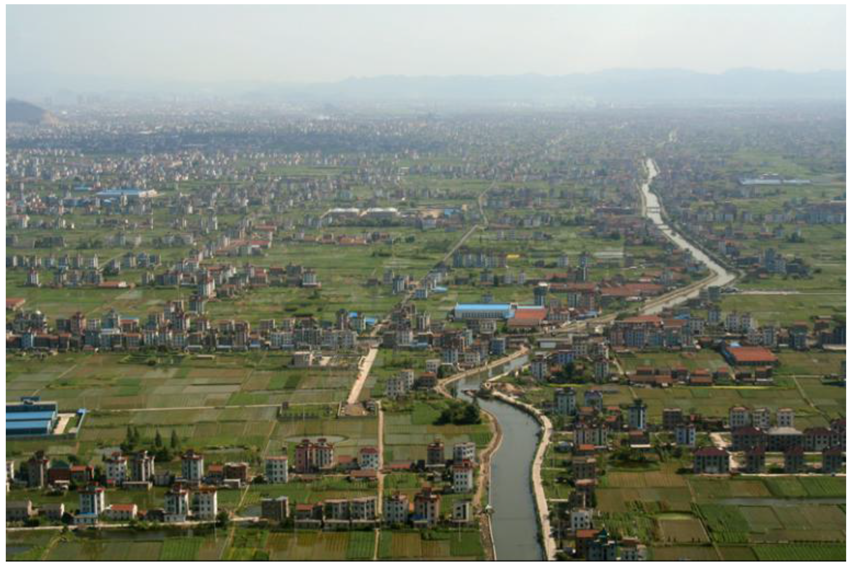
4.4. Leapfrogging Development

Urban sprawl in American cities refers to low density and leapfrogging development patterns. Common unwanted consequences of urban sprawl include loss of farmland, increases in transportation costs and distance, increases in automobile use and dependence, increases in the tax burden for provision of public services and infrastructure, worsening air and environmental quality, increases in energy consumption, and the development of social segregation [42].
The density of urban development throughout Chinese cities is relatively high compared to that in US cities. Many new developments are constructed arbitrarily, however (Figure 6). Development sites may seem efficient and resourceful due to their high densities and compactness of land use attributes, but spatial separation from city centers and urban built-up areas does not adhere to this notion, with similar consequences commonly found in sprawled American cities. Assuming that only upper-middle income households are able to afford apartments in these compounds, spatial income segregation is and will be emerging.
Figure 6. Urban leapfrogging development.
Sustainability 01 00384 g006

4.5. Whack-a-Mole Development

The whack-a-mole development pattern primarily takes place in China’s rural areas, particularly along eastern coastal regions (Figure 2). Benefitting from opportunities generated by rapid industrialization and urbanization, rural households gain substantial income growth and are able to redevelop their dwellings into modern structures on their homestead lots. Each dwelling unit is well structured, equipped and aesthetically pleasing. But collectively, they seem to have been constructed in a haphazard fashion (Figure 2). Each structure is built right in the middle of farm fields, creating a land development pattern that is costly in infrastructure provision and generates large negative externality. It will also be extremely expensive for farmland consolidation that is needed for scaled operation as well as infrastructure investments in agriculture. Farmland consolidation is conceivable and inevitable during urbanization and agricultural modernization. The former leads to the decline in rural population and increases average size of farming whereas the latter favors machinery uses and scale operations. Given the understanding that current rapid urbanization will continue into next a couple decades, some of these whack-a-mode developments will be engulfed into urban built-up areas. Redevelopment in these areas will be expensive economically, politically, and socially.

5. How Do We Understand China’s Urban Spatial Changes and Land Development?

5.1. Decentralization

Fiscal and economic decentralization in China in the past few decades have become the driving engines for economic success because of their impact on efficiency of the public sector and the incentives provided [43,44,45]. The decentralization of economic development has transformed local governments into entrepreneurs whose main task is to increase the competitive position of their cities by creating favorable institutional and physical conditions for attracting national and international investments as the major resource for economic development.
A by-product of fiscal and economic decentralization is increasing economic competition amongst local economies that is attributed to over-heating of the economy, causes economic instability, and reduces effectiveness of policy controls by the central government [44,45]. With respect to urban spatial development, local competition results in two kinds of issues. One is related to the mushroom-like booming of industrial estates. Job creation, GDP growth and fiscal tax revenues are among the most crucial developmental goals for local governments. They have used the creation of industrial parks and economic development zones as a strategy to attract businesses and investments [46].
Figure 7. Area and revenue of public land leasing to industrial development.
Sustainability 01 00384 g007
The other issue is related to the “race to the bottom” behavior of local government officials in granting land use rights. In order to attract investments and businesses, local governments usually offer use rights on the state owned land for free or at much lower prices through negotiation to investors than actual market prices. Public land leased to industrial projects through negotiation accounted for 75.69 percent of total leased land and generated 19.72 percent of total land leasing revenues in Hangzhou city in 2003 (Figure 7). Leased land through negotiation for industrial uses accounted for 35.02 percent but rendered only 0.08 percent of land revues for Guangzhou city at the same year. This implies that land access to residential and commercial development through tender and open bid as mandated is much more expensive than industrial uses. In fact, residential and commercial land areas are expensive. One developer paid $20,179,133 per acre to access land use rights in 2006, which is the highest land price ever recorded in Hangzhou city.

5.2. Fiscal Incentives

The Chinese government undertook a major fiscal/tax reform in 1994, aiming at a modernization of the public finance system [46]. The reform, which has been considered quite successful in terms of meeting its targeted objectives (two objectives are to increase the ratio of tax revenues over GDP and to increase the ratio of tax revenues by the central government over total tax revenue), has had large impacts on sub-national governments whose fiscal situations were completely turned around. Before the reform, revenue surplus for sub-national governments was $871.42 million in 1993. Yet after the reform, total fiscal deficit amounted to $24.65 billion in 1994, and further increased to $105.43 billion by 2003 [47].
The fiscal situation motivated local governments to begin their reliance on land revenues to finance urban expansion and urban infrastructure provision. The total area of leased land through the land use rights system was only 2,269 hectares in 1996, but increased to 62,058 hectares in 1998 and then to 414,782 hectares by 2003. Correspondingly, land conveyance fees increased from $4.15 billion in 1996, to $7.14 billion in 1998, and then to $158.96 billion in 2003, respectively [47].
From the demand perspective, the ability for local governments to raise revenues has been greatly enhanced by economic growth, housing privatization, and development of the real estate industry. From an institutional perspective, policy power in land taking and monopolized public land leasing enable local governments to obtain huge profits from land development process. The former enables local governments to obtain land for urban development at much lower prices and the latter makes local governments cash in large profits by charging developers and investors much higher costs for land. The price gap between land requisition compensations (prices paid to farmers) and land conveyance fees (prices charged to developers for land rights access) can be a factor of several dozens and land development becomes the source of the largest extra-budgetary revenues for local governments [48]. The magnitude of the importance of land revenues to local public finance is manifest in its ratio to tax revenues. Land generated revenues of $154 billion whereas total tax revenues for all level of governments were $292 billion in 2003. After discounting tax revenue shared by the central government, land generated more revenues than taxes by 26 percent for sub-national governments. Figure 8 reveals even astonishing figures, suggesting that land revenues can be as 1–3 times as big as budgetary revenue incomes (The overall contribution of land revenues to a city’s fiscal aspect is less important that what the ratio of land revenues to tax revenues suggests because of substantial intergovernmental transfers. On average, 42 percent of total budgetary expenditure for sub-national governments comes from the central government’s transfers).
The importance of land revenues to the local governments should be discounted since they are used for land leveling and on site infrastructure provision (roads, gas and electricity, water, sewerage, telecommunication, and greening of urban environment etc). Even after discounting all costs, however, land development still generates sizable revenues for local governments. Net profits from land development accounted for 25 percent of total land leasing revenues from 1992–2003 and over 60 percent of total extra budgetary incomes for sub-national governments. The net profits from land development can be as high as 90 percent in cities like Beijing in 2003-2004 (source: http://www.chinanews.com.cn/gn/news/2008/09-28/1398364.shtml).
Figure 8. Land revenue as percentage of annual local budgetary revenue.
Sustainability 01 00384 g008
As the literature suggests, extra budgetary revenues in China are more likely spent on improving transportation facilities, public squares and open space, rather than on education, health, and public safety programs [44]. Spending patterns of extra-revenues in Chinese cities are consistent with the literature. Land revenues in many Chinese cities are used to finance infrastructure for urban spatial expansion. Three cities in Zhejiang province, Shoaxing, Jinhua, and Yiwu, surveyed by a joint project of the World Bank and the Development Research Center of the State Council in 2005, reveal that urban spatial expansion heavily relies upon land revenue. About 32 percent of funds for financing urban expansion directly came from land revenues in Shaoxing, and figures were 51 percent and 22.3 percent in Jinhua and Yiwu, respectively [20]. Municipal governments also use land as collateral to access capital markets. In Shaoxing, the amount of land used as collateral accounted for more than 63 percent of total funds provided for urban expansion. Combining direct land revenues from land use rights leased and indirect revenues from land collateral, land is responsible for more than 95 percent of total financing of urban expansion in Shaoxing and 100 percent in Jinhua and Yiwu. The degree of reliance on land revenues for financing urban expansion raises an important question of sustainability and potential risks down the road as leasable state owned land is depleting (even taking land conversion into account) and less premium of land leasing will be generated with time.

5.3. Developers and Individual Stockholders

Rapid urbanization has presented unprecedented opportunities for farmers in urban fringe areas. In some cases, massive inflow and surge of rural migrant workers creates enormous demand for rental space. Rural villages adjacent to industrial parks and economic development zones and to urban-core areas offer locational advantages in housing these rural migrant workers. A village called Shangmeilin in Futian Ditrict of Shenzhen city had 241 indigent households in 2005, for example. They have built total 400 structures of 395,000 square meter building space that house 41,384 floating population. The average number of floating population (most of them are rural migrant workers) per household was 171.
Seeking maximum rental returns is one of the main incentives or motivations behind the whack-a-mole type land development. Confined geographically to their own homestead lots in many areas, rural households increase structure space by reconstructing taller buildings. Traditional houses in villages prior to 1978 were one story and flat in structure. They were torn down and rebuilt as 2–3 and then 5–10 story buildings in 1980s and 1990s, respectively. It took 20–30 years to demolish and rebuild houses before 1978, but declined to 4–5 years in late 1980s and further down to 2-3 years in the 1990s, respectively, in Shenzhen and Guangzhou [49].

5.4. Institutional Arrangement for Land Use and Development

Land ownership, land conversion, and public finance

Legal and institutional arrangements governing land use and development may have significant spatial implications. In China, institutional arrangements that enormously affect spatial developments include land ownership, public land leasing (called Land Use Rights system), land requisition, and farmland protection [50,51].
Land ownership in China is distinguished by its dichotomous structure in which virtually all urban land is state owned, whereas rural farmland is collectively owned (mining and manufactory land in isolated sites are also state owned). A public land leasing scheme was introduced in the late 1980s to increase land use efficiency and mitigate land use conflicts through pricing mechanisms. Under the public land leasing scheme, state owned land use rights can be separated from ownership and then be rented, sold, mortgaged, donated, and leased. Use rights need to be first acquired from the state by paying land conveyance fees to the respective local government. Land conveyance fees or lease prices of land use rights should be paid up front in a lump sum fashion prior to lease contact. Leasing terms range from 40 to 70 years, depending upon types of land uses (land use rights system and public land leasing is interchangeable in China; lease periods are 40, 50, and 70 years for commercial, industrial, and residential uses, respectively). Even though land is owned by the state, it is city or county governments that act as the representative of the state in managing land leasing [50,51].
The ability of local governments to raise enormous land revenues lies in the policy power of sub-national governments in land requisition and monopolizes land markets of public land leasing to developers. The land use rights system applies only to public land, which means that rural land must be converted to state ownership prior to development. By exercising policy power, local governments are able to take land from farmers at much lower prices and sell it to developers at much higher prices in monopolized land markets. The price difference can be in the order of factor of several dozen [48]. In one village in Fujian province, for instance, the local government paid approximately $8,700 per acre to farmers and then resold to developers for over $650,000 per acre for commercial housing. It is hardly surprising to observe massive scale of land development behind of huge land revenue potentials.

Farmland protection

Urbanization and industrialization have caused significant depletion of farmland [52]. This prompted the central government to take strict measures in farmland protection to address the concern in food security. The most influential measures include physical designation of capital cultivated land (or basic cultivated land) and 80 percent minimum requirement, which means the amount of basic cultivated land should account for at least 80 percent of total cultivated land in each of the provincial governments. The State Council’s approval is required before any basic cultivated land can be converted into urban uses. The Land Administration Law mandates the policy of zero-net loss in farmland (called the dynamic balance of farmland in China) to be implemented. It requires that one unit lost in farmland due to urban construction must be reclaimed somewhere else with same level of land production in agricultural yield (see the following section on the implications of farmland protection policy on urban spatial development patterns for more details).
Agricultural land productivity plays a predominant role in designating basic cultivated land that is strictly protected from development. Since most cities or a large part of the cities, if not all, are located at regions where land areas are not hampered by severe constraints for crop production, it is suggested that cities are surrounded by endowment of good farmland. As in the case in Canada, cultivated lands in urban fringes have higher agricultural productivities than in locations farther away from city cores [53]. Hence, urban spatial growth in city edge implies losses of quality farmland. Rigorous measures in farmland protection solely based on land quality will inevitably push land development farther away urban cores and result in leapfrogging urban spatial development.
The prohibition against land development on geographically designated basic cultivated land may render significant efficiency loss in land use and management. Sites inside basic cultivated land districts may have enormous economic value because of their access to transportation networks, adjacency to city centers, and proximity to job opportunities. Their economic values can far exceed total benefits from farmland protection. If so, net social welfare will be maximized by fully taking into account costs and benefits of zoning (such as agricultural) designation and by allowing tradeoffs of location determination for agricultural and non-agricultural activities rather than simply relying on land productivity in agriculture.

Role of land

The roles of land development are multi-faceted in China. As theory suggests, land demand is derived from urban development to accommodate needs in housing, jobs, infrastructure, and urban services. Empirical studies conducted by Seto and Kaufman [25] and Deng et al. [24] conclude that the outcome of economic growth is a key factor in determining urban spatial structure. Although the literature treats land as a production factor in housing production function and views demand for urban land as a derived demand [6,7], Land plays a small role in economic or urban growth. This is mainly because in the standard assumption in models of urban expansion land is available in perfectly elastic supply at a price equal to (a constant) agricultural rent, so that land adjusts frictionless to urban economic and population growth driven by other factors [54].
The unique combination of land institutions, land-people tension, uneven distributions of land resources and population, and land supply for non-agricultural activities suggests that land can be treated as a production factor for urban economic growth in China. Furthermore, the introduction of the land use quota virtually eliminates any possibility of incremental land conversion so that land supply is fixed in short run in China. Land becomes available for urban expansion only via explicit decisions of government officials rather than markets. Ding and Lichtenberg [54] look into the question of how urban spatial expansion influences economic growth in Chinese cities. They conclude through empirical tests that “the estimated value created by urban land is substantial, suggesting that land development constitutes an important part of the management of economic growth in major Chinese cities and thus is an important means through which decentralization reforms have fostered economic growth in China’s urban sector.” Duel land roles can help to explain both the incentives and motivation and then the scale and scope of land development across many Chinese cities.

5.5. Fragmented Planning System

Fragmentation

There are three types of plans that have profound impacts on urban development in China. The first is an economic development plan (Guomin Jingji He Shehui Fazhan Guihua) administrated by the development and reform department. The second type of plan is an urban plan administrated by the urban planning department and the third is a land plan administered by the land and resources department (environmental and transportation plans are also important in shaping urban landscape. But these two are beyond the scope of this paper).
Planning was the central theme in China’s socialist commanded economy that managed and controlled production, distribution, and consumption. The Five-Year plan (economic development plan) has been playing essential roles in urban economic affairs and growth. The primary objectives of an economic development plan include specific growth targets measured in GDP, industrial outputs, industrial structure, employment, incomes, and investments. An economic development plan is often supplemented by concrete capital projects that range from infrastructure such as highways, water transports, airports and ports to industrial establishments (development and expansion of state owned enterprises). With emerging market forces, the central government has shifted towards subsidies and tax and fiscal policies to stimulate and manage economic growth. Municipal governments continue to rely on capital and infrastructure projects to achieve economic growth objectives.
Urban planning, subservient to economic plans, has been used as a technical tool to materialize economic development [55]. Core elements of urban planning include the physical layout of infrastructure development, land arrangement for urban construction which includes determination of land demand for urban spatial expansion and physical locations, and spatial distribution of economic activities (urban planning, Chengshi Guihua, is a general term embracing urban master plans, detail plans and district plans. Detail and district plan are more design focused, under principle guidance of the urban master plan. In this paper, we refer urban planning to be an urban master plan).
Land planning administrated by land and resource departments is mainly viewed as a main tool to implement farmland protection policies or measures. Mandated by the 1998 Land Administration Law, all governments above the county level should develop a land plan (it would be called land use plan if direct translated into English, but the contents and meanings of such words are very different from what it implies in the US; to make a distinction, the term “land plan” is used in reference to China). the primary objectives of a land plan include: 1) to strictly protect basic farmland and control the amount of agricultural land for construction; 2) to improve land use efficiency; 3) to coordinate and balance land uses across regions; 4) to protect ecological and environmental systems and pursue the sustainable use of land; and 5) to maintain a balance of urban use and land reclamation). The means to achieve the objectives of farmland protection include 1) the requirement of a minimum share of protected farmland; 2) the designation of basic farmland districts; 3) a mandatory requirement of a zero-net loss in farmland; 4) approval by the State Council on land conversion of basic farmland; and 5) a top-down allocation of land use quotas. Land use quotas include the total amount for urban construction, the total amount for urban construction within cities and townships, the total amount for urban construction on farmland, the total amount for urban construction on capital farmland, as well as the total amount of protected farmland and capital farmland. The Land Administration Law requires that land plan at a lower level of government should be drawn up on the basis of a plan developed at a higher level of government in China’s hierarchical administration system (Article 18, the Land Administration Law). Vertical controls and management in land plan is much stronger than urban plan.

Issues and problems

A fragmented planning institution system has been blamed as least partially for ill-developed urban spatial patterns in China [56]. The fragmentation of plans is reflected in three important aspects. First, there is disintegration in contents. An economic development plan deals with capital projects without any consideration of site or location selection, whereas an urban plan determines zoning and infrastructure provision without any consideration, implicitly or explicitly, of costs or benefits of land use and pricing of land. Specifically, urban planning is focused on laying out a perfect end-state for a city and there has been little concern over the practical integration of services through budgeting, land markets and management, or for the cost and affordability of the expected end-state. Little attention has also been paid to the issues of economic efficiency or social equity. Therefore, the dominance of an economic development plan can lead to stochastic location selections for capital projects. A land plan prioritizes farmland protection based solely on the land’s physical quality without any consideration to the potential economic values of sites for non-agricultural uses.
The second aspect is associated with internal conflicts rising from the mismatch between development and approval of plans. An economic development plan is drafted by the development and reform department (or commission) on behalf of the government (each level of government—national, provincial, local, and international—has its own plan) and should be approved by the entire body of the people’s congress that convenes every five years at the same level (the county people’s congress approves the county’s plan, the city people’s congress approves the city’s plan, and so on). Like economic development plan, both the land plan and the urban plan are drafted by governments’ administrative braches (land and resources department and urban planning department, respectively) in each of four levels of governments. Unlike the economic development plan, both the land plan and the urban plan need different government levels for plan approvals. An urban plan (master plan) should be approved by the State Council for provincial capital cities including the four municipalities (Beijing, Shanghai, Tianjin, and Chongqing) directly under the Central Government or by the provincial government for other cities. A land plan is distinguished by its strong hierarchical structure of administration and approval procedures, reflected in the top-down allocation and determination of land use quotas. The State Council approves land plans for cities with a population over one million over while provincial governments approve land plans for countries, and cities with a population of less than one million.
The third and final aspect exposes the mismatches between the time goals of each of the three plans. The Five-Year Plan, has a five year planning period whereas the planning horizons for urban plans (urban master plan) and land plans (land master plan) are set at 20 years and 15 years, respectively. To make matters worse, the inception date of each of the three plans are usually different.
It is assumed that plans with long planning horizons should govern plans of short planning horizons for effective implementation. That is not the case in China. The five-year economic plan at all government levels above (including) counties is mandated by the Constitution while both urban plan and land plan are institutionalized by the Urban-Rural Planning Law and the Land Administration Law, respectively. The five-year economic plan, hence, has a much higher legislative status than other two plans. Both the Urban-Rural Planning Law and the Land Administration Law require that the urban plan and the land plan be drafted and developed under the requirements of five-year economic plans. This raises a fundamental question that is how to draw out a longer term plan (15–20 years) on the basis of a five-year plan while maintaining its efficiency and directory. This seems to be a task or a challenge void of any feasible solutions.
The fragmentation in planning systems (mismatch in three plans) becomes increasingly problematic in cities and counties mainly because location implications of plans are much stronger downward along the administrative ladder. City development requires mobilization of three key factors of labor, capital, and land for accommodating growth and development. Given approval requirements, city governments have less freedom in mobilizing land resources. The restriction of land resource mobility, which is needed to increase economic efficiency and to deal with future uncertainty in growth, results in inflexible zoning and land supply. This makes frequent revisions in urban plans inevitable to accommodate economic growth. Both lack of mobility and absence of pricing considerations result in efficient loss in urban spatial development.
The fragmentation of the three plans and the top-down control on land development has three unwanted consequences. First, it is associated with the behavior change of local officials. The top-down land quota allocation and tough approval procedures encourage city officials to request as much land area as possible and then worry less about land use efficiency and actual demand for development while the revenue incentive of land development encourages city officials to lease out as much land area as they can. The second consequence is a manifest in frequent revision of the urban plan. This is partly because more land is needed to achieve ambitious growth objectives and partly because urban plan revision is used as a technical tool for city governments to maneuver and circumvent strict land use controls. The third and final consequence is lack of a long term development vision and the systematic consideration in zoning and site determination for urban activities, which then leads to chaotic and stochastic development patterns.

Ill-designed planning regulations

There are several cases in which good intentions in planning and policy orientations generate unwanted outcomes. First of all, urban design has been a core element in urban plan practice, which stresses the improvement of urban living environments by implementing a minimum requirement of open and green space and strict control of FARs. Open/green space usually takes 30-35 percent of development lots (Figure 3) while the value of FAR is set to 1–2 for most residential development.
Secondly, open areas and green space are necessities for the quality of urban life. They provide amenities that are well capitalized into housing and land values and important to many urban activities such as educational institutions, health facilities, and residential enclaves, to name few. Greenbelts built to spatially separate manufacturing firms that discharge pollutants into the air and water can help to minimize environment impacts on urban residents. But green space separating commercial buildings in a CBD (Figure 2) adds little value to city competitiveness. It can make built-up urban landscape look beautiful and nice, but may impose huge direct and indirect costs on urban infrastructure, transportation, and agglomerative economy. These negative effects can outweigh any potential gains from ostensible beautification that does demand non-trivial maintenance inputs.

6. Final Remarks

Urban spatial development patterns have drawn a lot of attention because they directly influence travel demand and behavior, which are linked to climate change and energy consumption. A series of efforts in some American cities have been initiated to reduce auto-dependency and vehicle mileage traveled (VMT) through pricing policy (such as highway pricing) and smart growth that advocates mixed uses, compacted and dense developments, transit oriented development, and corridor development [42,54,55].
Although Chinese cities have different cultures, histories, and institutional arrangements governing land use and development, the principles of efficient urban spatial development are still applicable. Efficiency of urban spatial structure should be measured and gauged from the prospective of urban agglomeration, transportation implication, allocation of resources (land and capital), and environmental and social impacts. This paper reveals that there are prevailing development patterns that are inefficient in the rapid urbanization and industrialization in past decades and concludes that these inefficient patterns are directly or indirectly resulted from: 1) mal-functioning of planning institutions; 2) local competition and economic growth focused or oriented behavior of local government officials; 3) strong incentives behind land development and role of land in promoting city economic growth; 4) single-minded farmland protection; 5) single-minded urban planning practice; and 6) individual actions of stockholders for maximum rent seeking.
It is anticipated that China will experience rapid urbanization far into the 21st century, which will merge the two developing frontiers—rural and urban areas—more closely together and will result in a series of policy challenges in terms of employment pressure, housing sheltering for low income households, farmland preservation, environment protection, just name a few. China has demonstrated great abilities in promoting growth in past decades. It is hopeful that the Chinese governments take appropriate actions and measures to promote efficient spatial patterns for sustainable urban growth. More research on measuring urban development patterns and quantifying efficient losses is greatly needed in the future.

References

  1. Duranton, G.; Puga, D. Micro-foundations of urban agglomeration economies. In Handbook of Regional and Urban Economics; Vernon Henderson, J., Jacques-François, T., Eds.; North-Holland: Amsterdam, the Netherlands, 2004; Vol. 4, pp. 2063–2117. [Google Scholar]
  2. Boarnet, M.; Crane, R. Travel by Design: the Influence of Urban form on Travel; Oxford University Press: London, UK, 2001. [Google Scholar]
  3. Marshall, J. Energy-efficient urban form: reducing urban sprawl could play an important role in addressing climate change. Environ. Sci. Technol. 2008, 42, 3133–3137. [Google Scholar] [CrossRef] [PubMed]
  4. Brueckner, J.K. The Structure of Urban Equilibria: a Unified Treatment of the Muth-Mills Model. In Handbook of Regional and Urban Economics; Mills, E.S., Ed.; North-Holland: Amsterdam, the Netherlands, 1987; Vol. 2, pp. 821–846. [Google Scholar]
  5. Bertaud, A.; Malpezzi, S. The spatial distribution of population in 48 world cities: implications for economies in transition. Available online: http://alain-bertaud.com/AB_Files/Spatia_%20Distribution_of_Pop_%2050_%20Cities.pdf (accessed 2003).
  6. Dowall, D.E.; Treffeisen, P.A. Spatial transformation in cities of the developing world: multinucleation and land-capital substitution in Bogota, Colombia. Regional Sci. Urban Econ. 1991, 21, 201–224. [Google Scholar] [CrossRef]
  7. McDonald, F.J. Capital-land substitution in urban housing: a survey of empirical estimates. J. Urban Econ. 1981, 9, 190–211. [Google Scholar] [CrossRef]
  8. Maskell, P.; Lorenzen, M. The cluster as market organization. Urban Studies 2004, 41, 991–1009. [Google Scholar] [CrossRef]
  9. Jaffe, A.; Trajtenberg, M.; Henderson, R. Geographic localization of knowledge spillovers. Quarterly J. Econ. 1993, 63, 577–598. [Google Scholar] [CrossRef]
  10. Phelps, N.A. Clusters, dispersion and the spaces in between: for an economic geography of the Banal. Urban Studies 2004, 41, 971–989. [Google Scholar] [CrossRef]
  11. Storper, M.; Venables, A.J. Buzz: face-to-face contact and the urban economy. J. Econ. Geog. 2004, 4, 4. [Google Scholar]
  12. Feldman, M.; Audretsch, D. Innovation in cities: science-based diversity, specialization, and localized competition. Eur. Econ. Rev. 1999, 43, 409–429. [Google Scholar] [CrossRef]
  13. Fischel, W.A. Property taxation and the Tiebout model: Evidence for the benefit view from zoning and voting. J. Econ. Literature 1992, 30, 171–177. [Google Scholar]
  14. Fischel, W.A. Homevoters, municipal corporate governance, and the benefit view of the property Tax. National Tax J. 2001, 54, 157–174. [Google Scholar]
  15. Nelson, A.C.; Genereux, J.; Genereux, M. Price effects of landfills on house values. Land Econ. 1993, 68, 359–365. [Google Scholar] [CrossRef]
  16. Pettit, C.L.; Johnson, C. The impacts on property values of solid waste facilities. Waste Age. 1987, 18, 97–106. [Google Scholar]
  17. Li, M.; Brown, H.J. Micro-neighborhood externalities and hedonic housing prices. Land Econ. 1980, 54, 124–141. [Google Scholar]
  18. Bertaud, A. Metropolis: a measure of the spatial organization of 7 large cities. 2001; (in press). [Google Scholar]
  19. Lin, G.C.S. Metropolitan development in a transitional socialist economy: spatial restructuring in the Pearl River Delta, China. Urban Studies 2001, 38, 383–406. [Google Scholar] [CrossRef]
  20. Lin, G.C.S. Reproducing spaces of Chinese urbanisation: new city-based and land-centred urban transformation. Urban Studies 2007, 44, 1827–1855. [Google Scholar] [CrossRef]
  21. Wu, F. Urban restructuring in China's emerging market economy: towards a framework for analysis. Int. J. Urban Reg. Res. 1997, 21, 640–663. [Google Scholar] [CrossRef]
  22. Gaubatz, P.R. Urban transformation in post-Mao China: impacts of the reform era on China’s urban form. In Urban Spaces in Contemporary China: the Potential for Autonomy and Community in Post-Mao China; Davis, D.S., Kraus, R., Naughton, B., Perry, E.J., Eds.; Woodrow Wilson Center Press/Cambridge University Press: Washington, DC, USA, 1995; pp. 28–60. [Google Scholar]
  23. Bertaud, A. The spatial organization of cities: deliberate outcome or unforeseen consequence? 2004; (in press). [Google Scholar]
  24. Deng, X.; Huang, J.; Rozelle, S.; Uchida, E. Cultivated land conversion and potential agricultural productivity in China. Land Use Policy 2006, 23, 372–384. [Google Scholar] [CrossRef]
  25. Seto, K.C.; Kaufman, R.K. Modeling the drivers of urban land use change in the Pearl River Delta, China. Land Econ. 2003, 79, 106–121. [Google Scholar] [CrossRef]
  26. Liu, S. Functions of the land in city-expanding: report of investigation in three cities (countries) of Zhejiang Province. In Presented at the Joint Workshop by World Bank and Development Research Center of the State Council; Beijing, China, January 2007. [Google Scholar]
  27. Mobrand, E. Politics of cityward migration: an overview of China in comparative perspective. Habitat Int. 2004, 30, 261–274. [Google Scholar] [CrossRef]
  28. Ciccone, A.; Hall, R. Productivity and the density of economic activity. Am. Econ. Rev. 1996, 86, 54–70. [Google Scholar]
  29. Gabe, T.M. Establishment growth in small cities and towns. Int. Regional Sci. Rev. 2004, 2, 164–186. [Google Scholar] [CrossRef]
  30. Sedgley, N.; Elmslie, B. The geographic concentration of knowledge: scale, agglomeration, and congestion in innovation across U.S. States. Int. Regional Sci. Rev. 2004, 27, 111–137. [Google Scholar] [CrossRef]
  31. Cervero, R. The Master Planned Transit Metropolis: Singapore. In The Transit Metropolis: A Global Inquiry; Island Press: Washington, DC, USA, 1998; pp. 155–180. [Google Scholar]
  32. Richardson, H.W.; Bae, C.C.; Jun, M. Migration and the Urban System of South Korea. In International Handbook of Urban Systems: Studies of Urbanization and Migration in Advanced and Developing Countries; Geyer, H.S., Ed.; Edward Elgar: Cheltenham, UK, 2002; pp. 503–524. [Google Scholar]
  33. Cervero, R.; Wu, K.L. Sub-centering and commuting: evidence from the San Francisco Bay Area, 1980-1990. Urban Studies 1998, 35, 1059–1076. [Google Scholar] [CrossRef]
  34. McMillen, D.P. Employment Subcenters in Chicago: Past, Present, and Future Economic Perspectives; Federal Reserve Bank of Chicago, 2003. [Google Scholar]
  35. McDonald, F.J.; Prather, P. Suburban employment centers: the case of Chicago. Urban Studies 1994, 2, 201–218. [Google Scholar] [CrossRef]
  36. Naess, P.; Sandberg, S.L. Workplace Location, Modal split and energy use for commuting trips. Urban Studies 1996, 33, 557–580. [Google Scholar] [CrossRef]
  37. Levine, J. Employment suburbanization and the journal to work. Ph.D. Dissertation, Department of City and Regional Planning, UC Berkeley, 1990. [Google Scholar]
  38. Crane, R.; Chatman, D.G. As jobs sprawl, whither the commute? Access 2003, 23, 14–19. [Google Scholar]
  39. Murphy, R. The Central Business District; Longman Publisher: Chicago, IL, USA, 1972. [Google Scholar]
  40. Ding, C. Assessing urban spatial growth patterns in China during rapid urbanization. In The Chinese Economy; (in press).
  41. Ding, C. Consequences of Land Policy in China: Deciphering Several Emerging Urban Forms. In Smart Growth in China; Song, Y., Ding, C., Eds.; Lincoln Institute of Land Policy: Cambridge, USA, 2009. [Google Scholar]
  42. Growing Smart Legislative Guidebook: Model Statutes for Planning and Management of Change; Phase I interim edition; American Planning Association: Chicago, IL, USA, 1997.
  43. Qian, R.; Weingast, B.R. China’s transition to markets: market preserving federalism, Chinese style. J. Policy Reform 1996, 1, 149–185. [Google Scholar] [CrossRef]
  44. Blanchard, O.; Shleifei, A. Federalism with and without political centralization: China versus Russia. IMF Staff Papers 2001, 48, 171–179. [Google Scholar]
  45. Montinola, G.; Qian, R.; Weingast, B.R. Federalism, Chinese style: the politics basis for economic success. World Polit. 1996, 48, 50–81. [Google Scholar] [CrossRef]
  46. Wong, C.; Bhattasali, D. China: National Development and Sub-national Finance; CITIC Publishing House: Beijing, China, 2003. [Google Scholar]
  47. Xie, F.; Long, G.; Ding, C. China Real Estate Taxation System; China Land Press: Beijing, China, 2005. [Google Scholar]
  48. Ding, C. Land use policy reform in China: assessment and prospects. Land Use Policy 2003, 20, 109–120. [Google Scholar] [CrossRef]
  49. Meng, X.; Li, Y. Urban land supply in the Chinese transitional economy: case studies in Beijing and Shenzhen. In Emerging land and housing markets in China; Ding, C., Song, Y., Eds.; Lincoln Institute of Land Policy: Cambridge, USA, 2005; pp. 125–140. [Google Scholar]
  50. Yeh, A.G.O.; Wu, F.L. The new land development process and urban development in Chinese cities. Int. J. Urban Regional Res. 1996, 20, 330–353. [Google Scholar] [CrossRef]
  51. Lin, G.C.S.; Ho, S.P.S. The state, land system, and land development processes in contemporary China. Ann. Assn. Amer. Geogr. 2005, 95, 411–436. [Google Scholar]
  52. Lichtenberg, E.; Ding, C. Assessing farmland protection policy in China. Land Use Policy 2008, 25, 59–68. [Google Scholar] [CrossRef]
  53. Deng, X.; Huang, J.; Rozelle, S.; Uchida, E. Growth, population and industrialization and urban land expansion in China. J. Urban Econ. 2008, 63, 96–115. [Google Scholar] [CrossRef]
  54. Ding, C.; Litchenberg, E. Land and urban economic growth in China. In J. Regional Sci.; (in press).
  55. Leaf, M.; Hou, L. The “third spring” of urban planning in China. China Information 2008, 20, 553–585. [Google Scholar] [CrossRef]
  56. Yang, W. Theoretical Inquiry in Reform of Planning System (Guihua Tizhi Gaige de Lilun Tantao); China Price Publisher (Zhongguo Wujia Chubanshe): Beijing, China, 2003. [Google Scholar]

