Article

Whose Agency Counts in Land Use Decision-Making in Myanmar? A Comparative Analysis of Three Cases in Tanintharyi Region

by
Lara M. Lundsgaard-Hansen
1,2,*,
Flurina Schneider
1,2,
Julie G. Zaehringer
1,
Christoph Oberlack
1,2,
Win Myint
3 and
Peter Messerli
1,2
1
Centre for Development and Environment, University of Bern, 3012 Bern, Switzerland
2
Institute of Geography, University of Bern, 3012 Bern, Switzerland
3
Environmental Care and Community Security Institute, Yangon 11011 , Myanmar
*
Author to whom correspondence should be addressed.
Sustainability 2018, 10(10), 3823; https://0-doi-org.brum.beds.ac.uk/10.3390/su10103823
Submission received: 31 August 2018 / Revised: 11 October 2018 / Accepted: 12 October 2018 / Published: 22 October 2018

Abstract

:
Myanmar has experienced profound transformations of land use and land governance, often at the expense of smallholders. Empirical evidence on the agency of actors included and excluded in land use decision-making remains scarce. This study analyses who influences land use decision-making, how they do this, and under what circumstances smallholders are included. Comparing three land use trajectories in southern Myanmar, we analysed actors’ agency—conceived as the meanings and means behind (re)actions—in land use decision-making using data from focus groups and interviews. Results showed that uneven distribution of means can lead to unequal decision-making power, enabling actors with more means to exclude those with less means: smallholders. However, this only applies in the case of top-down interventions with mutually exclusive actor interests regarding use of the same land. Where interests are compatible or a mediator supports smallholders in negotiations, actors are likely to develop a collaboration despite unequal means, leading to smallholders’ inclusion in decision-making. Transformation of current land governance towards sustainable development could be promoted by providing mediators to actors with few means, ensuring equal access for all to formal land tenure, engaging with brokers in the land governance network, and improving access to knowledge and financial capital for actors with few means.

1. Introduction

Land governance in Myanmar has seen major changes over the past decades. The military government in power from 1962 to 2011 established a highly centralised, authoritarian state and a strongly regulated economy [1], reducing foreign influence to a minimum. Ethnic armed organisations resisted the central government in what became a long civil war, and Myanmar was outpaced economically by its neighbouring countries. The military government implemented agricultural master plans, reformed its land-related laws and policies, and granted concessions to wealthy or military-related investors in order to increase the number of prosperous large-scale agricultural projects that would boost development [2,3,4,5,6]. Previous local land users—most of them smallholders and many practising shifting cultivation—were usually excluded from land use decision-making in such government-initiated projects, and therefore lost access to the land they had been using. Many large-scale agricultural projects were implemented in ethnic minority areas or areas of insurgency, raising concerns that these development initiatives may have served purposes of control and state-building [7,8]. Moreover, agricultural expansion led to considerable deforestation [2,9]. With the partial opening of the country under the reform government from 2011 to 2016, national civil-society organisations as well as national and international nongovernmental organisations (NGOs) began to publicize the concerns of those who had experienced injustice, releasing a growing number of reports on land conflicts with detrimental outcomes for smallholders and ethnic minorities [10,11,12,13]. Besides acquisitions of arable land for commercial purposes, reports point to a growing number of land acquisitions aimed at conservation—also referred to as “green grabbing”—that threaten the legitimacy of local (mostly ethnic-minority) communities’ land use and hence their existence [10,14]. Furthermore, increasing liberalisation of the agricultural sector after 2005 and 2011 and the decrease in armed conflicts after 2011 led to spatial expansion of cash crops like rubber at the cost of forest ecosystems [2,15,16,17]. However, land users face a complex and often incoherent conglomerate of laws and policies that has accumulated over the past decades and makes land tenure a conflictive issue in Myanmar [18]. In areas where the Myanmar government and ethnic political organisations both claim authority and decision-making power, land users are even exposed to contradictory policies on land (see Appendix A). Also relevant for Myanmar’s current but fragile post-war process towards democracy [19], these developments in Myanmar’s land use systems pose considerable challenges to sustainability. The dynamics of such developments are crucially shaped by those actors whose agency counts [20]. Agency generally refers to actors’ ability to act in pursuit of their interests [21]. However, empirical evidence on agency in the context of land use system transformations in Myanmar is very scarce to date.
One of the current research frontiers of land system science is the search for a useful framework for assessing actors’ actions and agency in land use decision-making in the context of transformations of land use systems and land governance [22,23]. The definition of governance provided by Graham et al. [24] implies that a multitude of diverse actors—with their power, relationships, and accountability—as well as formal and informal institutions constitute the governance arena where decision-making processes take place [25,26]. In this study, we understand governance of land to encompass and formally and informally regulate, among others, access to land [27,28], land tenure and land use decision-making, land use changes and trajectories [22,29], customary practices, and formal policies and laws. Elements of land governance such as policies or decision-making processes can overlap, but may also conflict with one another or even be contradictory [24]. Scholars stress the critical role of actors’ actions, agency, and power relations in the context of land governance—including land use decision-making—and its transformation [30,31,32,33,34]. Eakin et al. [30] and Seto and Reenberg [35] suggested defining actors’ actions and reactions as the interplay between activities and agency, while agency in turn is a combination of meaning and means. According to Wiesmann et al. [21] and Bourdieu [36], the analysis of actors’ agency in terms of meaning and means can yield insights into power relations, as uneven distribution of material and immaterial means among actors can cause power imbalances. Accordingly, there is a growing need in land system science for better understanding how the agency of actors involved in and excluded from land use decision-making shapes short-term land use changes and long-term land use trajectories [22,29]. Given that actors contribute to and steer transformations [21,37,38,39,40], this understanding can also help to identify potential leverage points [41,42] for promoting transformations of land systems and their governance towards sustainable development.
The present paper contributes to this debate in land system science about actors’ actions and agency in land use decision-making and provides much-needed empirical evidence on whose agency influences land use decision-making in Myanmar, and why. The study was guided by the following research questions: How did actors’ actions and reactions shape land use trajectories in Myanmar? Whose agency counted in land use decision-making, and why? Moreover, as it seems particularly important from the point of view of sustainable development that smallholders in Myanmar are included in land use decision-making, we also asked: How did some smallholders manage to be included in land use decision-making? To answer these questions, we combined land system scientists’ understanding of action and agency with a human actor model [21] (based on multiple past papers [36,40]), and the concept of means [21,43] used by sustainability and development scientists.
In this paper, we first describe the basic characteristics of three selected land use trajectories (including official land zones, the timeline of land use changes, spatiotemporal dynamics, and territorial claims) and analyse actors’ actions and reactions in terms of their activities and their agency along each of the three trajectories. This analysis shows what happened along each of the three land use trajectories and why. In a second step, we compare actor interactions across the three land use trajectories, focusing on differences and similarities in agency related to the land use trajectories. This comparison sheds light on why some actors’ agency had a greater influence than others’, and how some smallholders managed to be included in the making of certain decisions along the land use trajectories. We conclude that uneven distribution of means among opposing actors in land use decision-making can indeed lead to an imbalance of decision-making power and targeted use of means by those who have more means to exclude smallholders who have fewer means. However, this finding only applies in the situation of top-down interventions where actors’ land use interests are mutually exclusive. In situations where actors’ land use interests were compatible or where a mediator supported smallholders in land use negotiations, actors developed a collaboration or at least mutual respect despite uneven distribution of means.

2. Methods

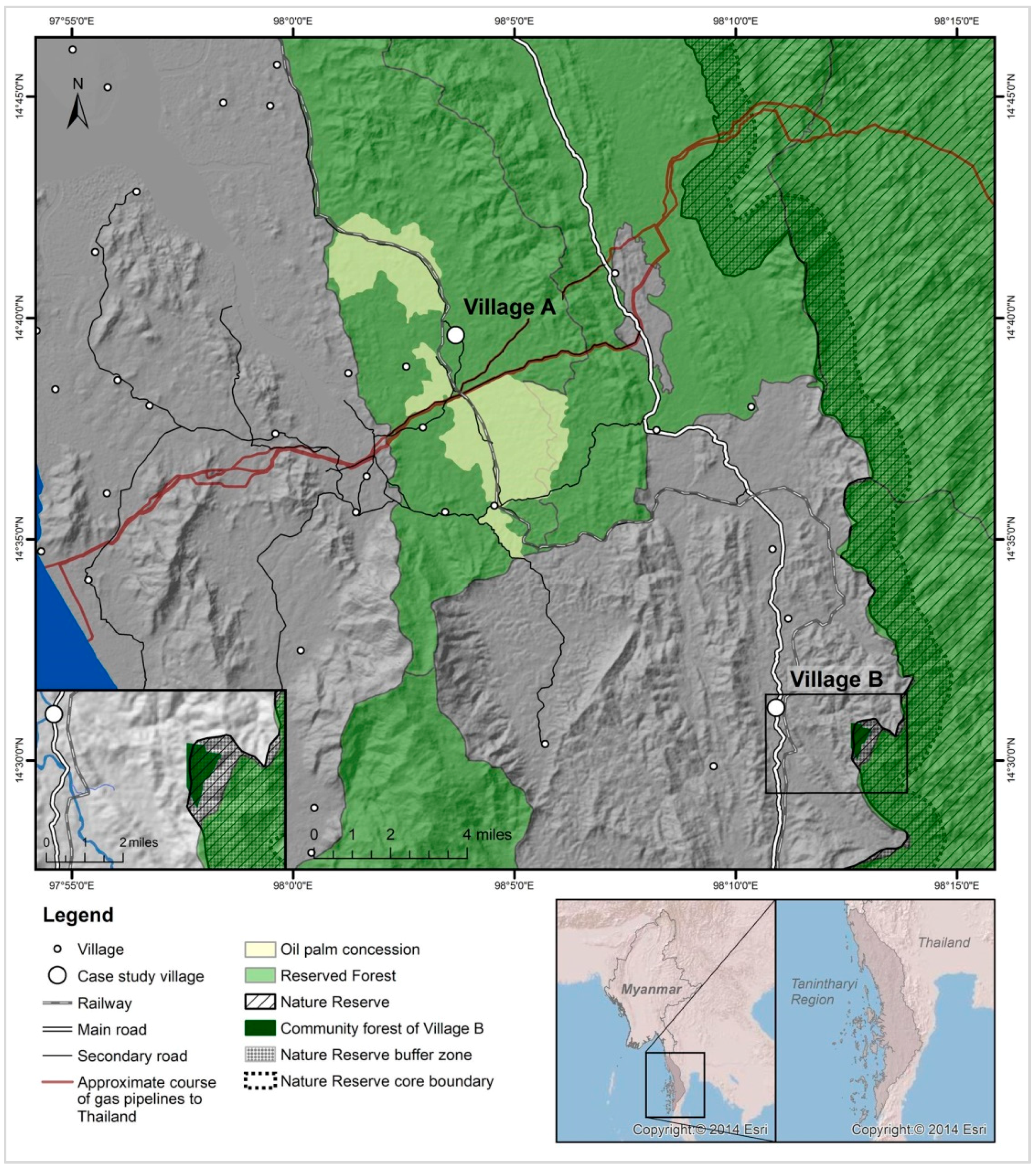
2.1. Study Area and Case Selection

We adopted a comparative case study design, analysing and comparing actors’ agency in the context of three different land use trajectories. Our study area is located in Tanintharyi Region, southern Myanmar (Figure 1). The area is a mix of forest and agricultural land, and land use has developed along various trajectories over the past 20 years. Within this area, we selected two villages for closer investigation. Village A has a predominantly Karen-Christian ethnic minority population, whereas Village B is mainly Burmese-Buddhist. The two villages are situated in different officially designated land zones. The study area contains large so-called Reserved Forest areas that were established under British colonial rule and today are administered by the central government’s Department of Forestry [44] (the term “central” refers to the national-level government of Myanmar). Anyone who uses land classified as Reserved Forest without permission from the Department of Forestry is acting illegally (see Appendix A). However, local communities have been using these forests for their own purposes without official permission. Village A is located inside a Reserved Forest. Accordingly, land users here can so far not apply for a formal land use certificate. Village B is situated in a zone designated for agricultural purposes, where land users can apply for a formal land use certificate; but it is also just outside a Reserved Forest which in 2005 was even upgraded to a more strictly regulated Nature Reserve. Villages A and B have each experienced one separate and one shared land use trajectory (LUT):
(1)
LUT 1, near Village A: Conversion of forest, shifting cultivation for subsistence, and some cash crop plantations to an oil palm concession managed by a military company.
(2)
LUT 2, near Village B: In 2005, conversion of the inconsistently enforced Reserved Forest into a more rigorously enforced Nature Reserve (LUT 2a); 12 years later, establishment of a community forest in the buffer zone of the Nature Reserve, making the use of some forest products possible again (LUT 2b).
(3)
LUT 3, in and around both villages: Expansion of private-sector commercial agriculture—predominantly cultivation of rubber and areca (betel) nut by various actors—at the expense of forest and shifting cultivation.
This case selection is particularly suited to address our research questions, because the initial land use and land tenure situation was very similar in all cases, whereas they differ in their development over the past 20 years. In the late 1990s, the only local land users in all three cases were smallholders, who used the forested land for shifting cultivation, some permanent crop farming, and the collection of forest products. The land use and tenure system was largely customary, without any formal land use certificates for any of the land users. In all cases, external actors entered the land system and contributed to a change in land use decision-making and in land use. In all cases, these external actors had the necessary means to dominate the smallholders, but in some cases the smallholders nonetheless managed to be included in land use decision-making. Thus, the three land use trajectories comprise different actor interactions that show how actors’ agency shaped the trajectories, starting from the same initial situation but achieving different outcomes of land use and land use decision-making. Comparison of the three cases enables us to draw conclusions as to why certain actors’ agency had a greater influence than others’, and why in some situations smallholders were included in land use decision-making even though they had fewer means than other actors.
Our cases are further influenced by another interesting aspect. Mirroring the turbulent history of civil war, both villages experienced many years of violent fighting between the ethnic political organisation Karen National Union (KNU) and the Myanmar government’s military as both parties claimed authority over the area. The KNU also formulated a land use policy in line with their own system and values (see Appendix A). Even today, the predominantly Karen population of Village A remains caught in the dilemma of which land use policies to adhere to—those of the KNU or those of the Myanmar central government.

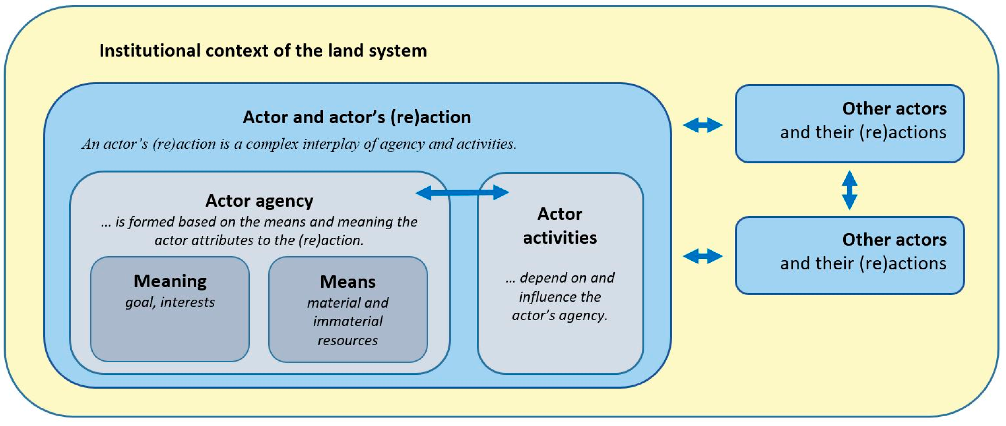
2.2. Conceptual Framework for Analysing Actors’ Actions and Reactions

To analyse actors’ (re)actions in land use decision-making in LUTs and their agency shaping these (re)actions, we used a conceptual and analytical framework that draws on the human actor model of Wiesmann et al. [21], the understanding of action and agency of Eakin et al. [30] and Seto and Reenberg [35], and the concepts of capitals or means of Bennett et al. [43], Wiesmann et al. [21], and their sources. In this study, we focus on collective and organisational actors.
Figure 2 illustrates the basic features of the framework. An actor can interact with other actors, and they might mutually influence each other’s actions and reactions. Actors are embedded in an institutional context, which may be the same or different for the various actors and influences their (re)actions. An actor’s action or reaction is a dynamic interplay of activities and the actor’s agency. Agency is comprised of two interdependent variables: The actor’s goal or interests give meaning to the (re)action, whereas material and immaterial resources constitute the means that an actor has to (re)act. A (re)action comprises a number of individual activities. Based on Wiesmann et al. [21], Bennett et al. [43], and their sources, we differentiate between (1) natural means; (2) human means; (3) physical means; (4) financial means; (5) social means; and (6) institutional means. We characterised each of these means based on their distinct components (Appendix B).

2.3. Data Collection and Analysis

Using this conceptual framework to structure the collection and analysis of qualitative data [45], we investigated all actors’ actions and reactions involved in shaping the three selected land use trajectories in the study area. We started with two exploratory focus group discussions with local residents in each village (n = 11 to 28 participants) to identify key land use changes, their timelines, and actors involved. On this basis, we identified the following main collective and organisational actors, (1) smallholders previously practising shifting cultivation and now growing various crops (land < 15 ha, see Appendix C)), including village leaders; (2) regional entrepreneurs with diverse activity portfolios often including rubber plantations in various places; (3) a private agribusiness; (4) a military agro-industrial company with a concession for oil palm cultivation; (5) landless immigrants and migrant workers; (6) the Nature Reserve Project (NRP); and (7) an international NGO that facilitates community forestry. We conducted a total of 31 semi-standardised interviews of 50 to 150 min each with representatives of these actors, collecting data on their activities, meanings, and means (see detailed agency components in Appendix B). We analysed the data from the focus group discussions and interviews using thematic coding and comparative content analysis. Where key data were missing or contradictory, we consulted further sources to enable triangulation. These included additional exploratory interviews with local actors and other experts and literature research.
Most interactions were conducted in a Myanmar language (Burmese) in teamwork by the first author of this paper and a research assistant; few were conducted in English. They were digitally recorded if participants agreed. The names of individual actors are kept anonymous to reduce the risk of repercussions. Data collection, analysis, and triangulation lasted from April 2016 to May 2018.

3. Results

3.1. Actors and Their (Re)Actions Shaping Land Use Trajectories

In this section, we present each actor’s activities and agency in each land use trajectory. Table A3 in Appendix C gives an overview of the main actors involved and their agency. As mentioned earlier, smallholders were the only local actors before the examined land use trajectories unfolded. Over time, other actors entered the study area, engaged in land use decision-making, and became locally active actors as well.

3.1.1. LUT 1: Conversion to Military Oil Palm Concession in Village A

As part of its Self-Sufficiency Plan, the military government decided in the late 1990s to reduce its dependency on imports of cheap palm oil and foster domestic oil palm cultivation on a large scale in the Tanintharyi Region (see Appendix A). It granted military-owned or -related companies as well as other private companies medium- to large-scale concessions and motivated, or sometimes even requested them, to establish oil palm plantations. The concession areas were usually located in what was officially considered “unproductive wasteland” (later also referred to as vacant, fallow, or virgin land; see Appendix A) or in Reserved Forests. The government only sometimes considered the existence of villages or natural ecosystems in the designated concession areas. The KNU strongly disagreed with this development.

Actors and Their Activities

Around the year 2000, the military government granted an area of 12,140 ha to the predecessor of the company running the plantation today (see Table 1). The arriving company briefly informed the village leaders, but did not consult them. The villagers disagreed with the establishment of the concession, but they did not dare to defend their land as civil war was still ongoing and the village was already experiencing violent oppression by military forces due to other reasons. The company started planting oil palms on about 1800 ha while claiming the remaining area of over 10,000 ha of the concession contract for future expansion. In 2003, the concession was handed over to today’s military agro-industrial company. Until 2010, this new company continuously expanded its plantations around Village A and other villages up to around 2750 ha (out of the originally permitted 12,140 ha) but did not relocate any villages. Various villagers lost access to parts or all of the land they had been using, as more and more land was converted into oil palm plantations. Those who had enough human and physical means cleared and cultivated other land in the vicinity of the village. After 2010, no more expansions by the military company have been observed (see Figure 1 for spatial extent). In 2011, the company signed a 30-year lease contract with the central Department of Forestry for the 2750 ha already converted and officially returned almost all of the remaining concession land (approx. 9000 ha) back to the Department of Forestry. Overall, this land use trajectory is an example of top-down interventions leading to abrupt changes in land use decision-making.
The company offered jobs to the surrounding villages’ residents, but most villagers refused. Some villagers worked for the company on a very short-term basis, but no villager was permanently employed. The around 200 workers employed by the company were almost all migrant workers from other regions of Myanmar.
At the time of fieldwork in 2017, the company and smallholders both reported several previous conflicts, but no active ones. The company representatives stressed that they tried to avoid clashes with smallholders but had not succeeded in preventing all conflicts. The villagers in turn insisted that the land had originally belonged to the local people and that they wished for it to be returned.

Actors’ Agency

The meanings behind the actors’ actions and reactions diverged strongly. The goal of the military company was to produce palm oil for their own soap factory, providing affordable soap for the domestic market and military camps throughout Myanmar (see Table A3). Local smallholders, who were extraordinarily poor and affected by military forces’ repression (unrelated to the company), strived to survive the civil war and produce enough food for their families by engaging in shifting cultivation for subsistence and few cash crops. They did not want to work on the military company’s plantation, as they preferred to cultivate their own land and had no interest in collaborating with the company. The result was an influx of mostly poor and landless migrant workers from distant places who were eager to work for the company to improve their difficult livelihood situation.
The company and the smallholders also had very different means (see Table A3). Strong social connections gave the military company access to influential land use decision-makers in the central and regional government. This enabled the company to obtain the formal concession—its institutional means that enabled it to disregard smallholders’ claims, who had no formal land use titles. Moreover, smallholders were intimidated by the company’s proximity to the military, with the military forces’ reputation among Karen people of being violent; this reputation of the military forces constituted an informal institutional means for the company. It explains smallholders’ reactive attitude of withdrawing instead of proactively opposing the company even though the company did never make use of any military forces. The company then drew on its major financial means to implement the conversions, acquiring physical and human means and obtaining knowledge from governmental representatives as well as national and international study tours.
Smallholders, by contrast, had no formal land use titles apart from their customary system of oral agreements with witnesses. Accordingly, they had no official permit for their shifting cultivation and crop plantations outside the village centre or for their use of the forest (see Table A3). Given that the area is a Reserved Forest, villagers’ agricultural practices were formally even illegal (see Appendix A). Moreover, smallholders hardly had any access to financial means, nor did they own or have access to substantial physical or human means.
For the immigrant workers, who found the employment through their personal network, the situation offered an opportunity to generally increase their means.

3.1.2. LUT 2: Conversion to Nature Reserve and Later Community Forestry near Village B

In 1992, the first international oil and gas company entered a collaboration with Myanmar’s central government to explore and produce natural gas for export to Thailand, despite disapproval of the KNU. Over the following years, several oil and gas companies settled in the study area. As environmental compensation for the pipelines to Bangkok crossing the so-called Myanmar Southern Forest Complex, three international oil and gas companies provided funding for the Nature Reserve Project (NRP), a central-level semi-governmental organisation at the Department of Forestry, tasked with establishing and maintaining a Nature Reserve. In 2005, the Nature Reserve was established on the area already designated as Reserved Forest (see Figure 1) and was entitled with the official land category of Protected Public Forest (for more background information on the Nature Reserve and Karen villages, see Appendix D).

Actors and Their Activities

Changes occurred in two phases (see Table 2). Before the establishment of the Nature Reserve, the villagers made full use of all forest products, hunted in the forest, and—due to population growth—continuously extended their shifting cultivation and plantations into what at that time was a Reserved Forest. The villagers managed and used the land and forest according to their customary system. In the first phase (LUT 2a), starting in 2005, NRP arrived as a new actor in the area and established the Nature Reserve several miles away from the settlement area of Village B. To our knowledge, there had not been any prior negotiation with local communities. However, NRP respected the already existing cultivations of smallholders. Over the first years, NRP held numerous information events and trainings for nearby villages, marked the boundaries, and set up ranger offices in villages. For villagers (and other land users), the establishment of the Nature Reserve meant that they were from that point on no longer allowed to use the forest for collecting timber and nontimber forest products or hunting, as well as to clear more forest for making forest land cultivable. Any trespassing and violating of rules could result in retribution. For security reasons, NRP rangers were not allowed to patrol in areas of active insurgency or fighting (inside the Nature Reserve), but they managed to build up law enforcement in the areas without insurgencies along the Western boundary of the Nature Reserve where Village B is located. Accordingly, people in this area increasingly refrained from forest use. This first phase of LUT 2 is thus another example of a top-down intervention leading to an abrupt change in land use decision-making.
In a later phase (LUT 2b), starting in 2015, an international NGO arrived in the Tanintharyi Region and opened an office near Village B. In collaboration with the Department of Forestry (including a memorandum of understanding) and NRP, this NGO conducted a series of information events in the area, motivating villages to apply for a community forestry (CF) certificate, which according to the law would have been possible since 1995. Like in many other regions, local villagers had not been aware of this possibility. With the intensified assistance, trainings, and funding from the NGO since 2015, Village B finally applied for a community forest in the buffer zone of the Nature Reserve (see Figure 1). NRP immediately agreed with their plans. In July 2017, the district-level Department of Forestry issued a 30-year land use certificate to the CF group. Thus this phase also led to an abrupt change in land use decision-making, but it was preceded by negotiations and consultations.

Actors’ Agency

In the first phase (LUT 2a), when NRP arrived, the meanings behind actors’ actions differed. While NRP mainly aimed to conserve biodiversity in collaboration with local communities (see Table A3), smallholders were concerned with surviving the civil war and having enough food. Accordingly, most smallholders wanted to use the forest as a source of food, building material, and land for cultivation expansion, and some, additionally, as a source of income based on informal selling of timber. NRP was willing to collaborate with local communities, but took measures to discourage smallholders from contributing to deforestation and forest degradation.
The distribution of means between these two actors was strongly asymmetrical. The formal connections between the central Department of Forestry and the oil and gas companies enabled the foundation of semi-governmental NRP as a new actor in a public–private partnership. From the beginning, NRP found itself well embedded in a strong collaborative social network between the Department of Forestry, the oil and gas companies, and itself. In addition, NRP could rely on its institutional means, namely the official mandate to implement and maintain the formally designated Nature Reserve. Moreover, having obtained substantial financial means (see Table A3), NRP could acquire human and physical means to implement the Nature Reserve. The smallholders, having far fewer means, could not compete with this new actor for access to the forest. They had no formal institutional means to support their forest use, but rather acted according to their customary system. The arrival of NRP drastically reduced their access to natural and physical means from primary forest, and indirectly also to financial means. At the beginning they did not accept this, but then they gradually gave up the use of primary forest. Being unaware of the legal options they had under CF regulations, they did not yet consider applying for a community forest.
In the latter phase (LUT 2b), after the arrival of the international NGO in 2015, the meanings behind all involved actors’ actions became compatible thanks to facilitation by the NGO. The NGO pursued the goal of empowering local people for sustainable forest management under the international REDD+ programme. Based on the formal CF Instructions under the Forest Law (see Appendix A) and with the support of the NGO, the CF group-to-be formulated its long-term interest in maintaining and using the forest’s natural resources. This meaning aligned with NRP’s meaning of conserving biodiversity in collaboration with local communities. Accordingly, NRP supported the endeavour of the CF group and the NGO to establish a community forest in the buffer zone of the Nature Reserve.
In this phase, too, the distribution of means among the actors was strongly asymmetrical (see Table A3). However, the actors did not use their means to compete with each other. The international NGO assisted the CF group in obtaining their ultimate institutional means: formal approval of their CF land use. The NGO did so by providing the group access to its social, human (knowledge and skills), and financial means. For instance, the NGO held several capacity building sessions with the CF group to inform them about their options and duties, assisted them with technical skills such as GPS geolocation for the CF application, supported them in communicating with the district Department of Forestry and other departments, and provided funding for purchasing tools needed for forest management.

3.1.3. LUT 3: Expansion of Private-Sector Commercial Agriculture in Both Villages

Actors and Their Activities

The private agribusiness in Village B was the first private actor to become considerably involved in commercial agriculture. The company had reacted to the government’s Self-Sufficiency Plan and the 2000 to 2030 Master Plan for the Agriculture Sector (see Appendix A), which promoted the cultivation of oil palms in Tanintharyi Region. The regional government granted the company permission to cultivate so-called wasteland (later referred to as vacant, fallow, or virgin land, see Appendix A), which was mostly forested and unused by villagers. The agribusiness started in 1998 (see Table 3) with 105 ha at the outskirts of Village B, mostly growing oil palm except for 10 ha of rubber. Later, the company realised that palm oil was not a profitable business and concentrated on other crops instead. Continual expansions up to today’s total area of 384 ha led to forest clearance, but not to conflict with villagers. The agribusiness and villagers have coexisted based on informal mutual consent, as the agribusiness supported the village with donations and exchanged frequently with the village leaders. With the establishment of the agribusiness, migrant workers from distant regions started to settle on the company’s compound.
In 2006, the agribusiness began to intensify rubber cultivation in response to institutional and economic incentives for rubber production created by the central government (see Appendix A). The incentives also attracted regional entrepreneurs from nearby towns, who acquired land at the outskirts of both villages with the help of local land brokers and also began to cultivate rubber, though only on a small to medium scale. Around 2007, inspired by the agribusiness and the regional entrepreneurs, all of whom are part of the regional elite, some smallholders also began to cultivate rubber. They usually converted some of their shifting cultivation plots to rubber plantations. With this gradual development of commercial agriculture, more migrant workers settled in or near both villages, usually working for the agribusiness or regional entrepreneurs. After the devastating cyclone Nargis hit Myanmar at the latitude of Yangon in 2008, the number of landless migrants looking for a future in the south increased significantly.
The decrease in armed conflicts and the market liberalisations that took place after 2011, as well as land-related reforms carried out in 2012, triggered a third wave of expansion of commercial agriculture. Smallholders stated that rubber and the areca nut (betel nut) were the main new crops they had started to grow since 2011, alongside some old crops such as cashew nut, black pepper, or fruits. In 2014, the agribusiness also began to produce areca nuts as they fetched a more attractive return on investment and a more stable market price compared to rubber. None of the actors have so far succeeded in producing good-quality rubber. Almost all rubber producers stated that income from latex production was much lower than what they had expected when they began to grow rubber.
No major conflicts between the coexisting actors have been reported. The agribusiness as well as the regional entrepreneurs—the regional elite—respected the smallholders’ customary land use system and in the predominantly Karen Village A also the KNU’s land use policy. The smallholders in both villages did not really welcome the rather speculative land acquisitions by regional entrepreneurs, as they reduced the availability of unused land; but they did not oppose them either.

Actors’ Agency

The meanings guiding actors’ actions were compatible. All involved actors’ actions and reactions were mainly driven by economic interests (see Table A3), and at the outset of this land use the trajectory of the availability of land was not yet a limiting aspect. Nonetheless, the reasons why actors developed similar meanings differed to some extent. Smallholders were unable to develop economic interests in commercial farming as long as more pressing problems such as food insecurity and civil war prevailed and markets were difficult to access. However, as the overall conditions improved, they began to strive for increased income generation in order to satisfy their basic needs and send their children to school. Regional entrepreneurs pursued economic interests not to satisfy their basic needs but to secure the livelihood improvements that their parents and they themselves had achieved (e.g., plantations, decent house, and increased financial income) and to further increase their resources to offer their children better prospects (mostly education). Some made speculative land purchases to further expand their investment. The private agribusiness, also driven by economic interests, additionally aimed at overall regional development. For instance, the main owner was also involved in regional trading associations, political consulting, health infrastructure and service development, and many more projects. Migrant workers from distant regions, also striving for more income, found a possibility to improve their basic livelihoods, similar to the smallholders. In addition, migrant workers hoped to earn enough money to eventually be able to buy their own land (some in their hometown and some in the study area).
The natural, human, physical, financial, and social means that the various actors owned or had access to increased proportionally to the migrant workers to the smallholders to the regional entrepreneurs to the agribusiness (see Table A3 in Appendix C). The distribution of institutional means, however, followed a different pattern: it depended on the village and the relevant official land zone. While all land users in Village B had reasonable formal tenure security for their plantations (see Table A3 in Appendix C), land users in Village A—including regional entrepreneurs—had never held formal land use certificates because Village A is located in a Reserved Forest where agriculture is officially illegal.

3.2. Comparative Analysis: Whose Agency Counted in Land Use Decision-Making and Why

Table 4 summarizes the results of the comparative analysis of the three land use trajectories studied. The trajectories show different patterns of agency. Looking at actor relations, the new actors were predominant in LUT 1 and LUT 2a, whereas smallholders exercised agency in a more pronounced manner in LUT 2b and LUT 3, resulting in peaceful coexistence among smallholders and new actors. Regarding territorial claims, one might expect that smallholders are excluded from decision-making when actors with more means claim the same land. This proved to be true in LUT 1 and LUT 2a. In LUT 2b, however, smallholders in the form of a CF group managed to be included in land use decision-making even though they claimed the same land as NRP, who had ample means. These and other differences can be attributed to the varying patterns of agency described in the following section.

3.2.1. Role of Meaning

Among the four situations in the three LUTs (LUT 2 comprises two situations), we encountered two situations where actor interests (meanings ascribed to actions) diverged and two situations where they were compatible. In the two situations with diverging interests, we noted that smallholders had been excluded from land use decision-making. In LUT 1, the military company aimed to produce palm oil for soap manufacturing, while the smallholders’ concern was to maintain their food security and survive the civil war involving various armed conflicts around their village. In this situation, the military company was using its means (see Table A3) to implement the land use changes against the smallholders’ will. In LUT 2a, NRP implemented a Nature Reserve with the aim of biodiversity conservation, whereas the smallholders aimed at maintaining their food security. NRP excluded the smallholders from land use decision-making by gradually restricting their access to the forest, making use of its vast means to successfully implement the Nature Reserve. Both situations represent a top-down intervention without prior negotiation where smallholders would have been involved.
In the two situations where actor interests were compatible, coexistence was peaceful and even constructive without any major top-down interventions. In LUT 2b, the NGO as well as the CF group-to-be both aimed at communal use of the forest. The NRP and the Department of Forestry both agreed with this, as long as the CF group complied with their rules and regulations for sustainable forest use. After approval of the community forest and the formation of a CF group, the smallholders were therefore no longer a competing actor for NRP, but rather a potential collaborator for improved forest management who pursued similar interests. Members of the CF group and the NRP forest rangers even stated that they now usually patrolled the forest together and that this was giving them increased satisfaction. In LUT 3, all actors indicated that they aimed to generate more income from their land use. As a rule, no actor interfered with any other land user. In many cases, actors even benefitted from each other: While smallholders perceived the agribusiness and regional entrepreneurs as economic innovators and important casual employers, the agribusiness and regional entrepreneurs partly relied on smallholders as casual labourers on their plantations. Even the migrant workers’ interest in generating income to improve their livelihood did not conflict much with any other actor’s interests, including those of the smallholders. Migrant workers usually worked permanently or at least seasonally on the plantations of the agribusiness and regional entrepreneurs. Smallholders were mostly interested in short-term casual labour on plantations, as they preferred to work on their own land (with few exceptions). When local smallholders or their children sought permanent or seasonal employment, they usually migrated to nearby Thailand, where wages were higher than in Myanmar.

3.2.2. Role of Means

The distribution of means among the actors was uneven in all four situations (see Table 4). New actors entering the land system usually had substantially more means than the local smallholders—with the exception of the migrant workers.
Comparison of all situations showed that institutional means were relevant in enabling actors to become land use decision-makers in three of them, namely in LUT 1, LUT 2a, and LUT 2b. In all three situations, the change in land use decision-making was abrupt. In LUT 1 and LUT 2a, smallholders did not own or have access to formal land titles issued by the central government, whereas the new actors held land use certificates or a mandate from the central government. In LUT 1, the military company used its concession to claim decision-making power over the land under concession, while the smallholders had no formal certificate to prove the rightfulness of their land use and tenure; what was much worse was that their activities were formally illegal according to Reserved Forest regulations, even though these regulations had never been strictly enforced (see Appendix A). In LUT 2a, NRP received a mandate from the central Department of Forestry to implement the Nature Reserve. This official mandate legitimised their appropriation of decision-making power over the designated forest, whereas in this case, too, the smallholders had no formal recognition of their use of the nearby forest to support their right to being included in decision-making. In both LUT 1 and LUT 2a, smallholders were excluded from land use decision-making because new actors brought formal institutions into a customary system—formal institutions that may have existed but until then had not been enforced in the study area. In LUT 2b, the very same smallholders who had been excluded in LUT 2a regained access to decision-making on the same forest by formally registering as a CF group and receiving a formal CF land use certificate. However, the CF group needed to comply with the national-level instructions for CF and Nature Reserve regulations. Thus, in all these situations, formal institutional means such as land titles—unlike informal, customary institutional means—where critical for actors to be included in or to dominate land use decision-making. As confirmed by several interview partners, the higher the level of the government authority issuing a land title, certificate, or mandate, the more power it gives its owner.
Strikingly, in all these situations, the actors’ social means were crucial to obtaining formal land titles. In LUT 1, the military company was closely connected to the national- and regional-level committees in charge granting land concessions. In LUT 2a, NRP was closely connected to the forestry departments at all levels who decided, based on existing legislation, to implement the Nature Reserve. In LUT 2b, the CF group received access to substantial new means by collaborating closely with the NGO. Even in LUT 3, the agribusiness owner proved to be well-connected to the regional, district, and township governments, to whom he repeatedly applied for permission to cultivate “wasteland”. These individuals and organisations thus seem to have used their social networks as instruments for obtaining the necessary formal land use certificates. Our findings show that access to social networks at higher administrative levels can be decisive when it comes to being included in or even dominating land use decision-making.
Further, in LUT 2b, access to knowledge (human means) was essential in enabling the CF group-to-be to apply for a community forest. One might argue that in LUT 1, LUT 2a, and LUT 3 knowledge about how to apply for a land use certificate was no less essential for actors to acquire their institutional means.
In LUT 3, where land use decision-making changed gradually in patches, all means were similarly important, and each actor acted according to the means they had and the meanings they attributed to their actions. Their peaceful coexistence may be explained by the fact that previous and new land users did not claim the same land, but rather acquired separate plots. However, it might also be connected to the circumstance that the new actors were from the same region and more familiar with and considerate of the conditions in which smallholders in the area live and work.
In all four situations, one type of means was relevant for the implementation of changes in land use, but not obviously relevant for bringing about changes in land use decision-making: financial means. Having decision-making power did not necessarily lead to an immediate change in land use. This was apparent in LUT 1 and LUT 2a, where the changes in land use happened gradually after land use decision-making had changed abruptly. Implementing land use changes required various types of means such as human (e.g., labour), physical (e.g., tools, saplings), and financial means. Financial means enabled actors to acquire the other types of means where necessary. Accordingly, access to financial capital is another particularly powerful means in land use competitions. For instance, the military company (LUT 1) was able to maintain and expand its plantations even though palm oil production was not profitable because it had access to income from other businesses and tax income. The NRP (LUT 2a) used its vast funds to hire project staff, conduct information events, and mark the Nature Reserve boundaries, for example. In LUT 3, actors with greater financial capital were able to acquire larger areas of land, hire labour, and access more or newer technologies for agricultural production and communication.

3.3. Inclusion of Smallholders’ Agency in Land Use Decision-Making

Since the inclusion of smallholders in land use decision-making is important from the point of view of sustainable development, we sought to identify situations and conditions where smallholders’ agency was, indeed, included in land use decision-making. The comparison of all actors’ interactions revealed three circumstances that contributed to—but did not guarantee—smallholders being included in land use decision-making despite the presence of actors who had more means than the smallholders did:
First, having a formal land tenure certificate issued by the Myanmar government and being located in an agricultural land zone contributed to smallholders being able to decide about use of their own land. In Village B, which is located in an agricultural land zone, holders of either a “Form Seven” land use certificate (after 2012) or at least a crop tax receipt for the land they cultivated did not experience any dispossession by actors with more means. Some smallholders who had not paid the crop taxes (for various reasons) and therefore had no crop tax receipt were dispossessed by other land users with more means. In Village A, most land use activities of smallholders and regional entrepreneurs are illegal because the land is in a Reserved Forest. For that reason, land users have so far never had a formal land title. Some smallholders in Village A reported that the KNU had started to issue land use certificates to Karen people to increase their land tenure security, and that smallholders greatly appreciated this. However, they also stressed that these certificates would be less legitimate before the Myanmar national law than a land use certificate issued by the Myanmar government.
Second, a mediating actor with considerable means (the NGO in LUT 2b) facilitated capacity building and constructive mediation on land use decision-making for actors with comparably few means (smallholders), who then formed a CF group (LUT 2b). This facilitating actor considerably improved the smallholders’ inclusion in land use decision-making. However, this was only possible because there was a legal framework that all actors could refer to; in this case, the national Forest Law with the CF Instructions (see Appendix A).
Third, compatible land user interests (meanings ascribed to actions) facilitated collaboration (see also Section 3.2.1). Where coexisting actors had similar rather than mutually exclusive land use interests there was no conflict or exclusion. The collaboration of NRP with the CF group and the NGO (LUT 2b) and private-sector-based agricultural expansion (LUT 3) illustrate how a peaceful environment can stimulate constructive collaboration or at least mutual respect. In these two situations, the smallholders’ agency had a substantial influence on land use decision-making.

4. Discussion

Myanmar has experienced profound transformations of land use systems and land governance, with different actors being included in or excluded from land use decision-making [1,2,4,6,11]. Development actors in Myanmar as well as land system scientists and sustainability scientists have broadly stressed the importance of understanding the agency of actors involved in—or excluded from—such transformations [21,22,30,32,33,34,37,38,39]: This knowledge is needed if we aim to promote the transformation of land governance towards sustainable development.

4.1. A Framework for Analysing Actors’ Actions and Reactions Based on Their Agency

Overall, we perceived the applied actor (re)action framework as useful for understanding how and why actors shape land use changes in the short term and land use trajectories in the long term. The operationalisation of agency through meanings and means—with their various components (see Appendix B)—helped to capture both visible and invisible aspects of actions and reactions. As stated by Wiesmann et al. [21], we can only observe activities and, to some extent, means, but a (re)action encompasses more than just these visible aspects. Our framework’s operationalisation of agency enabled us to disentangle the complexity of actions and reactions by identifying the visible aspects of activities and means while also capturing the invisible aspects of meanings and some types of means, such as institutional, social, and financial means, as well as knowledge. Insights into the subtle differences between different actors’ agency improved our understanding of how and why some actors were included in land use decision-making whereas others were excluded, and hence, why some actors’ agency had a greater influence on land use decision-making than others’ did. These insights also enabled us to identify factors that made it possible for smallholders to be included in land use decision-making. Overall, our analysis helped us locate leverage points for sustainable development, as it captured past and current weak points in the land system, such as the formalisation of land titles or lack of social networks, knowledge, and financial capital among smallholders. However, the operationalisation of the framework also entailed some challenges for data collection. It is a time-consuming and lengthy process, especially if samples need to be large. Moreover, respondents must be willing and able to share their data, which might not always be the case in every context.

4.2. Leverage Points for Transforming Myanmar’s Land Governance Towards Sustainable Development

The current Myanmar government is already undertaking many actions for transforming the land governance towards more sustainable development. As actors contribute to/steer transformations [21,37,38,39,40], the conducted analysis of actors’ agency in land use decision-making supported the identification of potential leverage points [41,42] for further supporting the transformation of this land system towards sustainable development. We have identified four leverage points. First, as experienced in LUT 2, where the interests of the competing actors (smallholders and NRP) regarding use of the same land diverged, a mediator (the NGO) facilitated constructive communication between the two parties and further actors, supported the identification of a shared interest, and improved smallholders’ access to necessary means such as social networks, knowledge, financial capital, and finally formal land tenure, which they would not otherwise have been able to obtain. This finding is consistent with studies from other countries which showed how, for example in Cambodia, domestic and international NGOs supported local communities’ resistance against large-scale land concessions [46] and exerted pressure on the government [47], or how, in Mozambique, NGOs collaborated with smallholders to avert land and water deals initiated by commercial investors [48]. Thus, even in conflictual large-scale land acquisitions, external actors can create advocacy support and mediators can assume the role of a facilitator [49]. In Sweden, mediators managed to support trust-building between actors, facilitate knowledge generation, and foster innovations for adaptive comanagement of wetlands [50]. Therefore, the targeted and preferably constructive involvement of such mediators—also referred to as bridging or boundary actors [50,51,52]—in land use decision-making and land governance negotiations could serve as a leverage point for transforming Myanmar’s land governance towards greater sustainability.
Second, our results have shown that formal land tenure recognition was crucial. Those actors who owned or had access to formal land titles were able to dominate or at least be included in land use decision-making. Other studies from Myanmar have also criticised the lack of formal land tenure recognition for smallholders [11,12,18,53]. At the time of submission of this paper, the Myanmar government was undertaking various attempts to integrate traditional land use systems and the use of Reserved Forests in its laws. So far however, the institutional framework of the Myanmar government has formally recognised neither customary or communal land tenure arrangements nor the use of land in Reserved Forests—situations that are both widespread in Myanmar’s ethnic regions [4,12,53,54]. This makes it impossible for many smallholders—like those in Village A—to access formal land tenure, thereby putting them at increased risk of expropriation and exclusion and limiting their access to credits and mortgages. However, some studies from Myanmar have demonstrated that the current institutional framework of formal land tenure recognition—“Form Seven” under the 2012 Farmland Law—is discriminatory against women and ethnic minorities [4,11,55]. Studies focusing on other developing countries in Southeast Asia and Africa have further highlighted that national attempts to formalize land may risk to open windows of opportunity for land speculation, elite capture, and legitimisation of state land, which in turn lead to poverty traps, as speculative or accumulative land acquisitions often happen at the expense of the more vulnerable groups [56,57,58]. These risks, and the importance of achieving good land tenure governance, are even greater in post-war countries, where institutional confusion still largely prevails and a variety of actors make claims on land tenure solutions as a crucial element of the peace process [57,59,60]. This is also the case in Myanmar. The formalisation of land titles including formal recognition of customary tenure system thus stand out as an important leverage point for transformation towards sustainable development. However, relevant procedures and impacts must be well-assessed, just, transparent, and monitored, and involved actors must be held accountable so as to prevent unsustainable trajectories like social exclusion or environmental degradation.
Third, we have seen in all LUTs that social networks played a crucial role in accessing the means needed to be able to participate in land use decision-making (e.g., formal land titles, knowledge, and financial capital). International conceptual and empirical studies underscore that social networks can have a strong influence on natural resource governance [61,62,63,64]. In Cambodia and Laos, for example, factors such as access to power, political networking, and connections to influential elites proved to be relevant in enabling citizens to successfully resist land grabbing [46,65]. Central or bridging actors [66,67] occupy an influential position in a social network and can become brokers for transformations [68,69], as their networks enable them to mobilize specific actors and also a comparably large number of actors. Scholars and development practitioners likewise underline the crucial role of informal power holders (e.g., traditional or religious leaders, socially, economically, or politically influential elites, and respected experts) in transformations, as they can influence both their followers and formal power holders in one direction or another [70,71,72,73]. In Kenya, for example, a social network study managed to identify the bridging actors between coastal fishers and conservation organisations and thereby contributed to improving a socially accepted mode of conservation diffusion through more effective collaboration [74]. Based on our own results as well as similar findings from other studies, we consider targeted work with central or bridging actors in the role of brokers and with their social networks another considerable leverage point for supporting transformation of Myanmar’s land governance towards sustainable development.
Finally, our results have shown that knowledge and financial capital were both useful means to access other means. Other studies provide similar findings. A study from Rwanda, for example, illustrated how financial capital was necessary for farmers to join associations that controlled fertile swamplands; this led to the exclusion of poorer households, who could not afford the membership fees [57]. In Chile, lack of access to loans prevented smallholders from entering the emerging fruit and vegetable business; as a result, most smallholders sold their land to entrepreneurs [75]. Smallholders in Vietnam and many other countries also lack knowledge of how to access land titles [76,77]. Accordingly, we argue that providing access to knowledge (e.g., land tenure options, agricultural techniques, credit options, etc.) and financial capital (e.g., microcredits) to actors who have comparably few means—such as smallholders or landless people—might serve as a further leverage point for enabling sustainable land use decision-making in Myanmar.
Nonetheless, our results also showed that LUT 1 and LUT 3 led to considerable environmental degradation (e.g., deforestation) and that LUT 1 and LUT 2a increased socioeconomic disparities (e.g., exclusion of smallholders from land use decision-making). Future land governance in Myanmar should therefore also endeavour to design sustainability-oriented regulations for land use decision-making and land use.

5. Conclusions

In this paper, we have presented an analysis of actors’ actions and reactions, as well as the agency behind them, in land use decision-making along three land use trajectories in southern Myanmar. We identified whose agency—conceived as the meanings and means behind (re)actions—influenced land use decision-making at what stage of the trajectory, and why.
In situations where the previous and new actors all claimed the same or at least parts of the same area of land for their use, formal land tenure recognition was the decisive means that secured decision-making power over the relevant land. Such certificates were always obtained through social connections; knowledge was likewise needed to obtain formal land tenure recognition. Where previous and new actors claimed different land for their use and land use and land use decision-making changed gradually in patches, all means were equally important and each actor acted according to the means they had and the meanings they attributed to their actions. In all situations, financial means were useful in implementing land use changes because they enabled actors to acquire other necessary means.
In two situations, smallholders were excluded from land use decision-making as a result of a top-down intervention. This exclusion also concurred with the circumstance that the competing actors pursued mutually exclusive interests regarding use of the same land. In both these situations, those actors who had the stronger means dominated land use decision-making. In one of these situations, a mediator later facilitated the identification of compatible interests and supported the establishment of a constructive collaboration between the previously competing actors. Overall, the existence of shared interests among actors led to the development of a peaceful and constructive collaboration.
We can conclude that an uneven distribution of means among actors may indeed create a power imbalance, especially in the context of top-down interventions. However, it does not necessarily lead to the exclusion of those with fewer means from land use decision-making or to any other disadvantages for them. Three circumstances increased the chances of smallholders with comparably weak means being included in land use decision-making: First, their access to formal land tenure recognition; second, support from a mediator in building knowledge and negotiating land use decision-making; and third, compatibility of the competing actors’ interests.
In view of the global struggle for sustainability, we consider it the scientific community’s responsibility to contribute to sustainable development with its research. From this study, we learnt that in order for sustainability science and land system science to be transformative, their proponents should further investigate actors’ actions and agency, also in other fields than land governance, simply because actors influence transformations. Furthermore, we believe it is promising to critically analyse actors’ interests (meanings attributed to action) and means, as well as the distribution of means among actors, with a special focus on social networks, power relations, sources of power, conditions of social and environmental justice, and the institutional context influencing actors. Regarding the study of land governance transformations in Myanmar, we see three priorities for further critical and transformative research. First, as shown in this study, formal land tenure recognition is vital for securing actors’ access to land; but land formalisation can also have negative social and environmental impacts. It is therefore important to learn more about the implications of past and current land tenure formalisation processes and potentials for formally recognizing customary land tenure systems in Myanmar. Second, there is need for a better understanding of the social networks of near and distant actors in land governance. Knowing how actors are connected to which other actors, comprehending their agency in interactions, understanding what kinds of institutions influence them, and identifying key actors in the network would facilitate the identification and targeting of leverage points for transforming land governance towards sustainable development. In connection with the analysis of social networks, further research could focus on power relations in Myanmar’s land governance. Third, if land governance transformation is to be oriented towards just and sustainable development, the transformation process itself requires further attention. Transdisciplinary approaches and concepts such as social learning might prove useful to identify enabling and hindering factors of collective (social) learning among current and potential key actors in land governance.

Author Contributions

L.M.L.-H. conceived the idea, conducted the fieldwork and case study, and drafted and finalised the manuscript. L.M.L.-H., F.S., J.G.Z., C.O., W.M. and P.M. contributed to the discussion of the conceptualisation, methods, and results of the study, and commented on draft versions. Additionally, W.M. managed the administrative requirements for conducting the fieldwork.

Funding

This research was supported by the Swiss Programme for Research on Global Issues for Development (r4d programme), funded by the Swiss National Science Foundation (SNSF) and the Swiss Agency for Development and Cooperation (SDC) [400440 152167].

Acknowledgments

The research was carried out as part of the project titled “Managing telecoupled landscapes for the sustainable provision of ecosystem services and poverty alleviation” (Project No. 152167) in Myanmar in collaboration with, and with extensive support from, the Environmental & Economic Research Institute (ERRi) and later the Environmental Care & Community Security Institute (ECCSi). We thank the regional authorities in the Tanintharyi Region, the township authorities, and the village leaders for their support throughout the fieldwork. We further thank the villagers and all other interview partners in the Tanintharyi Region and elsewhere for their great hospitality, their patience, and their valuable contributions to the study. Special thanks go to Nwe Nwe Tun for her invaluable research assistance and translations, the entire project team at ECCSi Myanmar (Win Myint, Nwe Nwe Tun, Cing Don Nuam, and Aung Myin Tun) for the wonderful collaboration, Florian von Fischer for coproducing the map, Joan Bastide for supporting the research and publication process, Tun Tun Thein for providing valuable feedback, Marlène Thibault for editing the manuscript, and the three anonymous reviewers for their constructive comments.

Conflicts of Interest

The authors declare no conflicts of interest.

Abbreviations

CFcommunity forestry
CSOcivil society organisation
GPSglobal positioning system
KNUKaren National Union
LUTland use trajectory
NGOnongovernmental organisation
NRPNature Reserve Project
REDD+Reducing Emissions from Deforestation and Forest Degradation
VFVvacant, fallow, and virgin (land)

Appendix A. Institutional Complexity in Myanmar

Land users in Myanmar are exposed to a complex conglomerate of overlapping and sometimes conflictive laws and policies [18]. This institutional complexity and opacity adds an additional layer of challenges for those who often neither understand nor benefit from legislation, such as smallholders or ethnic minorities. Table A1 summarizes some of the most relevant land-related laws and policies and their implications for land users. Some of the challenges inherent in the legal framework presented in Table A1 are discussed further below. The three land use trajectories examined in this study need to be understood against the backdrop of this dynamic institutional complexity.
Table A1. Main land-related laws and policies of Myanmar and their implications for land users.
FieldLaw or PolicyImplications
Land zonesThe multitude of laws and policies since 1850 generated an array of different land categorisationsThere are 22 different land zones (land categories defined by the government) in Myanmar [6]. Depending on the land zone, a specific law or policy is binding and a government department is responsible for administering the land. Legal land use purposes are stated in the respective laws and policies. In some land zones, dwellers can be forcibly evicted [78].
ForestForest Law (1992) and Forest Policy (1995)The law and policy define rules for governing the country’s so far overexploited forests with a greater focus on conservation, sustainable use, and community participation [44]. However, the law still permits logging by specific actors to a certain degree [79].
Community Forestry Instructions (1995, reformulated in 2016)Local communities can apply for community forests to fulfil basic livelihood needs and reforest degraded forests [5,44].
Land acquisitions“Wasteland Instructions” (1991) 1These instructions encouraged large-scale export-oriented plantations on “wasteland” [4] and provided agribusinesses with easier access it [5]. 2
Self-Sufficiency Plan (1990s)The cultivation of oil palms and other food and industrial crops were strongly encouraged to reduce Myanmar’s dependency on imports [2,3].
2000–2030 Master Plan for the Agriculture Sector (2002)The Ministry of Agriculture and Irrigation prioritised large-scale agriculture for industrial production, especially rubber, oil palm, and other strategic crops [2].
Rubber boosting policies (2005/06)In 2005, government quotas for rubber (45% of private harvest was reserved for government) were entirely abolished [15,16,17].
Moreover, with China’s Opium Substitution Program in 2006, Chinese agribusinesses received financial incentives and enjoyed eased bureaucratic procedures in Northern Myanmar [5].
Vacant, Fallow, and Virgin Land Management Law (2012)Similar to the Wasteland Instructions (see above), this law made it possible to allocate any “vacant”, “fallow”, or “virgin” land to domestic or foreign investors [6]. 2
Land use certificatesFarmland Law (2012)The law created a (quasi) 3 private land use property right, providing official land use certificates to farmers [4]. However, the Farmland Law is not valid for “forest land” administered by the Department of Forestry, such as Reserved Forests.
Forest Law (1992)On some (but not all) “forest land” administered by the Department of Forestry, any person or company can apply for a permit to implement an economic project such as an agribusiness, but must then strictly adhere to the exact contents of the approval [80].
Land Use Certificates of the Karen National Union (KNU)Over the past few years, KNU’s Agriculture Department has measured Karen people’s agricultural land and issued land use certificates to provide more land tenure security to Karen people [81]. However, according to our interview partners, so far these certificates are not recognised by the Myanmar government.
Ethnic minority policyKNU Land Policy (1974, amended in 2005 and 2014)KNU’s land policy of 2014 aims at promoting social progress, security, and justice in the management of land ownership. It claims to be in line with human rights standards, prioritizing the occupation and use rights of marginalised and vulnerable people and village communities. Moreover, it emphasizes the social and ecological functions of land, forests, fisheries, water, and related natural resources [81,82].
1 Full title: Duties and Rights of the Central Committee for the Management of Cultivable Land, Fallow Land and Waste Land [4]. 2 According to Kenney-Lazar ([5], p. 6), “wastelands” were effectively defined as land without a land title, the same as “vacant, fallow and virgin lands” [6]. 3 Under certain circumstances, the government can rescind a land use certificate [4].
Even though the Forest Law of 1992 attempted at promoting sustainable development of forestland, several challenges remained. Reserved Forest land is a protected class of forestland that was primarily intended for the production of forest products, including community forestry [4]. Oberndorf [4] (p. 7) however highlighted the diverging worlds of practice in reality and theory in law: “Many areas of Reserved Forest land in the country have been converted to agricultural production by smallholder famers or village settlement without a change in the classification of the land. In many areas, land classified as Reserved Forest land on existing maps does not match current use. Rural populations that have traditionally used areas of Reserved Forest land for generations are technically in violation of the Forest Law, though local authorities have often granted permission to use these lands in the past”. The Forest Law allows reclassification of forestland to accommodate actual use, but implementation is still pending [83]. Unlike Reserved Forests, Protected Public Forests are intended for conservation purposes. The mismatch between official land use regulations and actual land use is less prevalent in Protected Public Forests than in Reserved Forests, as they tend to be well demarcated [4]. However, the creation of a Protected Public Forest on land where communities have already established traditional livelihoods can be problematic [4,10].
In addition to the challenges related to forestlands, most of the laws and policies highlighted in Table A1 seem to have reduced smallholders’ land tenure security and eased land acquisitions. Especially the “Wasteland Instructions” (1991) and the Vacant, Fallow, and Virgin Land Management Law (short VFV Law, 2012) weakened smallholders’ land tenure. Both only recognised land as already being in use if farmers had official land use certificates, which most farmers in these land categories lacked—and still lack; accordingly, they acquired the status of “squatters” [12]. Ferguson [84] and Kelley-Lazar [5] argued that “wastelands” were a political land category used by the government to gain control over land and populations especially in ethnic minority areas and areas of insurgency. In 2012, the concept of “wastelands” was formalised in the VFV Law [4,5]. Over the past decades, “wastelands” or “vacant, fallow, and virgin lands” were preferably awarded to state-owned economic enterprises, joint ventures, corporations, or private individuals, regardless of the original landowner or customary traditions and laws [4,5]. Responding to pressures from civil society at the time of submission of this paper, the Myanmar government approved an amendment to the Vacant, Fallow, and Virgin Land Management Law of 2012 that excludes ethnic lands under customary systems from the category of vacant, fallow, and virgin land. However, the exact interpretation and implementation of this amendment is pending.
Another challenge arose from several changes in the military government’s national policies regarding oil palm and rubber concessions in the 1990s and 2000s. The Self-Sufficiency Plan and the 2000–2030 Master Plan for the Agriculture Sector aimed at turning Tanintharyi Region first into a “palm oil bowl” [2] and second into an area for rubber expansion [85]. With respect to palm oil, in the 1990s the Myanmar government needed to reduce its dependency on palm oil imports from other Southeast Asian countries [6]. Consequently, the government decided to become self-sufficient for palm oil, choosing the Tanintharyi Region as the most suitable region for oil palm cultivation due to its climatic conditions. With regard to rubber, in 1989 the government’s State Law and Order Restoration Council (SLORC) allowed rubber producers to sell 55% of their latex on the private market—while the rest had to be sold to the government [16]. In 2005, these government quotas were entirely abolished [16], assumedly due to the government’s intention to promote rubber as one of Myanmar’s strategic cash crops [15]. In 2006, China and Myanmar agreed on China’s Opium Substitution Programme, attracting many Chinese investors to northern Myanmar [2] and increasing demand for Myanmar rubber in China. Moreover, rubber prices increased throughout the 1990s and 2000s until 2011 [86]. Subsequently, companies with personal or business connections to the military were awarded large-scale land concessions for oil palm cultivation [2,3]. Additionally, over the following years the government created several financial incentives for rubber cultivation [5,15,16]. This Self-Sufficiency Plan in combination with the previously established land-acquisition-friendly legal environment prepared the ground for a series of large-scale land acquisitions in Tanintharyi Region.
Moreover, documentation of land titles has been inconsistent and unequal over the past decades. The Farmland Law (2012) introduced the “Form Seven” [18], the official land use certificate for farmers of any scale. A link between the Farmland Law and VFV Law eventually also permitted VFV lands to be reclassified as farmland [4], thus permitting VFV landholders to apply for such a land use certificate under the Farmland Law. However, land users whose plantations were officially located on Reserved Forest land were still not eligible to apply for “Form Seven” (source: personal communication, respondent anonymised). Prior to 2012, nothing like “Form Seven” had existed. Land users practised different forms of written documentation, such as tax receipts, “Form 105” (certified map), or booklets [18], or they arranged oral agreements with witnesses. Many land users still do not hold a “Form Seven” (due to pending applications or nonsuitability of land zone). For average residents like smallholders, the township-level Department of Agricultural Land Management and Statistics (DALMS)—previously called Settlement and Land Records Department (SLRD)—normally issues the “Form Seven” based on a mandate from the Committee of the Farmland Law (also called “Administrative Body of the Farmland Law”) (source: personal communication, respondent anonymised).
Finally, the Karen National Union’s Land Use Policy partly conflicts with the Myanmar government’s land-related laws and policies. While some land users in the mixed-control area might prefer to adhere to the KNU’s policy, others might prefer to follow the Myanmar government’s legislation (source: personal communication, respondent anonymised). Adhering to both sides’ legislations is rather challenging due to their different nature. This conflictual overlapping of different institutions adds another level of complexity to land governance.
It is also worth noting that until 2012 our case study area was called a “brown region”, which was a governmental term for an area of mixed control between the Myanmar government and ethnic organisations usually involving active fighting [87]. The KNU and the military were heavily engaged in armed conflict until the first regional ceasefire agreement in 2012. During this time, law enforcement was almost impossible. On the one hand, some villagers made unrestricted use of natural resources to improve their livelihood, engaging both in legal activities and officially illegal activities like logging or mining. On the other hand, villagers often suffered human rights violations committed by new actors entering the area from outside, and these were never held accountable for their crimes. Depending on the conflict situation, government staff sometimes did not dare to visit rural areas, including to measure cultivated land and hand out tax receipts that land users could have used to document government recognition of their land use (source: personal communication, respondent anonymised).

Appendix B. Overview of Agency Components in the Actor (Re) Action Framework

Table A2 provides an overview of how we operationalised agency components in our study.
Table A2. Overview of the definitions of agency components in this study.
MeaningMeans (Own or Have Access to Material and Immaterial Means) 1
Natural MeansHuman MeansPhysical MeansFinancial MeansSocial MeansInstitutional Means
Goals or interests actors pursue with their (re)actionLand, crops, forest, animals, etc.Labour, knowledge, skills, etc.Built infrastructure, machines, communication, transportation, etc.Turnover, funding, remittances, credits, etc.Social network, relationships, type of interaction, etc.Land tenure (formal and informal), political status, cultural identity, etc.
1 Means are defined according to Wiesmann, et al. [21], Bennett, et al. [43], and the sources they cite. In line with the grounded theory approach [88], we subsume political, institutional, and cultural means—different sources use different terms—under institutional means.

Appendix C. Overview of Main Actors and Their Agency

Table A3 summarizes the main actors involved in land use and land use decision-making across the three land use trajectories studied.
Table A3. Overview of the main actors and their agency across the three land use trajectories (LUTs) studied.
ActorsMeanings (Goals, Interests)Material and Immaterial Means (That Actors Own or Have Access to)
Natural MeansHuman MeansPhysical MeansFinancial MeansSocial MeansInstitutional Means
Locally involved actors before the studied LUTs evolved
Smallholders before LUTs evolvedTo have enough food and survive the civil war; some Karen fled to Thai refugee campsLand for shifting cultivation of rice, sesame (for oil), and other subsistence crops, some cattle, few cash crops, very little mining, full access to forestHelp each other with cultivation, never hire labour, traditional knowledge (cultivation and other), almost no access to other knowledgeRoad in bad condition, only bullock carts, no telephones, no electricity;
road and vehicles improved in early 2000s
Very little income (approx. 20% of today’s), no remittances, no credits; some were able to pawn goldSocial contacts outside nearby villages very limited, relationship to government officials almost inexistentNo formal land titles (only crop tax receipts at most) 1; customary practices, almost no political representation;
Karen (Village A) and
Dawei-Burmese (Village B) ethnicity
Locally involved actors during and after the evolution of the LUTs
Landless immigrants and migrant workers
(LUT 1 and LUT 3)
To generate income for their basic livelihood, return home, and/or buy landUsually no land apart from vegetable garden (0.2 ha), limited access to forestNever hire labour, learn by doing, through instructions from peers or supervisorsCompany employees: access to some resources via the company;
Casual labourers in village: very few physical means
Income of USD 440 to 2200 per year and person 2; no access to credits, but advance payment of salary possible; sending but no receiving of remittancesAccess to employment only through social contacts (relatives and friends) at place of origin and destination, usually limited to personal networkCompany employees: some have contract, some oral agreement;
others: oral agreement;
“outsider” status among villagers
Military agro-industrial company, production branch of military conglomerate
(LUT 1)
Operational: to produce palm oil for soap manufacturing serving domestic market and military camps in Myanmar;
strategic: follow objectives of conglomerate 3
2748 ha of oil palm plantations confirmed in current contract, totally 3720 ha managed (incl. mill, roads, waterways, etc.); original concession covered 12,140 ha13 permanent service staff, 160 plantation labourers (migrant workers) with contract, 25 casual labourers (locals); managers access cultivation knowledge via the government 4, Facebook, and other companiesMill for raw palm oil production (10 t per hour), water pumps, machine-aided tools, electricity from 10 generators, internet via personal smartphone, relatively good transportation vehiclesAnnual turnover of approx. USD 420,300, but no profit, therefore rather dissatisfied; access to funds from mother company, no need for access to creditsTop management closely connected to national and regional military elite and other influential national and regional actorsAt first concession permit from central Department of Forestry, since 2011 30-year land lease contract; proximity to military, with military forces’ reputation among Karen people of being intimidating and violent
Nature Reserve Project (NRP) (semi-governmental organisation)
(LUT 2)
To conserve biodiversity and protect endangered species in collaboration with local communitiesThe Nature Reserve encompasses approx. 170,000 ha of forest (ranging from primary forest to heavily degraded forest and villages with their cropland)Approx. 80 staff, of which 50% local project staff, 50% government staff; access to most types of knowledge when needed, receive technical support when neededGood transportation vehicles, full communication equipment (incl. computer and internet), electricity at headquarters, access to generators for some local officesInternational funding: USD 450,000 annually from three international oil and gas companies 5Close collaboration with departments of forestry at all levels, some collaboration with international NGOs, researchers, KNU, and local population, support from oil and gas companiesLand officially designated “Protected Public Forest” (under 1992 Forest Law), formal mandate from central Department of Forestry to implement the Nature Reserve
After 2015:
International NGO
(LUT 2)
To empower local people for sustainable forest landscapes in the Asia-Pacific region (under REDD+ programme)Does not use forest; has facilitated 94 Community Forestry (CF) permissions covering a total of 20,234 ha in Myanmar (Jan 2018)Myanmar office: 13 permanent, seven volunteer staff;
Tanintharyi office: three staff; access to most types of knowledge when needed, skills of employees improved
Good transportation vehicles, full communication equipment (incl. computer and internet), electricityInternational funding: USD 85,000 annually for the national CF programme; approx. USD 970,000 annually for all programmesClose collaboration with departments of forestry at all levels, with other national and international NGOs, civil society organisations (CSOs), researchers, and local populationNationally registered international NGO, viewed by local population as professional supporter
After 2016:
Village B
CF group
(LUT 2)
To maintain and use natural resources over the long term57 ha of community forest in the Nature Reserve buffer zone25 member households; access to information and capacity development via the NGONo physical infrastructure apart from personal resources, access to CF is difficult (no good paths)USD 1390 seed money from NGOClose collaboration with NGO; in exchange with Department of Forestry, NRP, and other CF groups in the region, elsewhere in Myanmar, and abroad (via NGO)30-year CF certificate from district Department of Forestry; internal constitution (board, members, procedures etc.)
Smallholders today
(LUT 3)
To generate income for their basic livelihood and children’s educationLand for mostly cash crops only, some mixed cropping, approx. 50% less land accessible today than before, on average 7.4 ha (2–15 ha) 6, very limited access to forestSome hire few labourers 2–3 times a year, some do not; cultivation knowledge from parents, peers, some training; access to market price (via traders); some training from CSOs and NGOsRoads are reasonable, access to motorbikes and cars; telephones, but usually no use of internet; limited electricity from generators or solar panelsAnnual household turnover (not profit) approx. USD 1400 from cash crops and casual labour 7, some access to informal credits with high interest rates, some people receive remittancesContacts mostly through personal network, some loose contacts to government officials, CSOs and NGOs, traders, middle(wo)men, entrepreneurs, etc.Village A: no change in land title situation;
Village B: change in 2013 from weak land use recognition (crop tax receipts) to “Form Seven” land use certificate from township government; in both villages: increased political representation (incl. CSOs)
Regional entrepreneurs
(do not live in the villages but use land there)
(LUT 3)
To generate income and keep their land in order to maintain their established livelihood and offer their children a good futureRubber plantations in different locations, small to medium scale (8–120 ha), some fallow landUsually do not work on the plantations, hire permanent and/or casual labour; access to relevant knowledge (in Myanmar language), satisfactory (but not excellent) own and employee skillsMost have a car and motorbikes, and machines to aid cultivation; some have a water pump, internet via smartphone, and electricity at their headquartersAnnual turnover from rubber approx. USD 18,800 (USD 2600–44,300), unclear whether profitable or deficient; some have additional sources of income, all have access to creditsWell-connected among regional elite and traders, access to government officials, usually members of business-oriented rubber association, rather good relationship with local population“Form Seven” from township government for all sites around Village B, but none around village A (Reserved Forest land); viewed by local population as innovators
Agribusiness (private company)
(LUT 3)
Short-term: to generate income and improve produce quality;
long-term: regional social and economic development
Owns over 400 ha, cultivates 384 ha (oil palm, rubber, areca palm, and others); started with 105 ha, continuously expanded; would prefer to cultivate more land to improve returns to scale22 permanent staff, 48 seasonal or temporary staff; mostly migrant workers, some locals; access to relevant knowledge (in Myanmar language), satisfactory (but not excellent) own and employee skillsSmall mill for raw palm oil production (3 t per 5 h), rubber processing (for air-dried sheets), machine-aided tools, water pumps, electricity from two generators, internet via personal smartphone, relatively good transportation vehiclesAnnual turnover approx. USD 119,900; apparently not profitable, therefore dissatisfied; company owners have additional sources of income; no credits neededOwners closely connected to regional elite and traders, high position in regional rubber association, politically active, good access to government, good relationship with local population30-year land lease permit from regional government from the outset (applied in 1998, received in 2000); later additional land under “Form Seven”; viewed by local population as innovator and agribusiness expert
1 However, crop tax receipts did not include shifting cultivation fallows, and farmers did not always register all cultivated plots because they could not afford to pay the taxes. 2 Household income depends on several factors, including (1) gender (women earn less); (2) how many people per household can work (including teenagers); (3) type of employment (permanent, seasonal, or casual); (4) position (supervisors earn more than other employees); (5) skills (special skills, like rubber harvesting, milling etc. are better paid); (6) other economic activities (e.g., selling of betel leaves, rubber saplings, etc. in spare time); and others; 3 The overall conglomerate’s goals are (1) to guarantee the welfare of current and retired military servants and their families; (2) to create job opportunities for local people; and (3) to support regional development. 4 Usually via the Perennial Crops Division or the Perennial Crops Research and Development Centre (PCRDC) of the Ministry of Agriculture, Livestock, and Irrigation (MoALI). 5 More than three oil and gas companies run activities in the case study area; we count only those who effectively contribute to NRP. 6 We defined the maximum area farmed by smallholders to be 15 ha—rather than the internationally widespread 2 ha—because most smallholders in the two villages cultivated between 2 and 15 ha of land. We also encountered a small number of wealthier local medium-scale farmers, who cultivated 20–83 ha, as well as local entrepreneurs with a diverse portfolio of activities and diverse sources of income. However, as these two groups were not perceived as main actors by the focus group participants, we did not include them as actor categories in this study. 7 Annual turnovers reported ranged between USD 110 and USD 4150. Most smallholders nowadays also do casual labour for other plantation owners in order to increase their income.

Appendix D. The Nature Reserve and Karen Villages

As elaborated in Section 3.1.2, the Nature Reserve was established thanks to an environmental compensation for the pipelines to Bangkok crossing the so-called Myanmar Southern Forest Complex. Three international oil and gas companies provided funding for the Nature Reserve Project (NRP), a central-level semi-governmental organisation at the Department of Forestry, tasked with establishing and maintaining the Nature Reserve. Besides this environmental compensation, the international oil and gas companies also support Karen and non-Karen village development through corporate social responsibility programmes (in the area near the companies’ compounds) such as infrastructure development, school construction, provision of medical teams, agricultural trainings, micro-finance programmes etc., which is greatly appreciated by the local villagers. For constructing the pipelines, most smallholders received financial compensation from the companies for the land they lost to the pipelines. However, one company has been accused of substantial human rights violations in Karen villages in connection with construction of the pipelines in the 1990s and early 2000s.
The KNU did not approve the settling of the oil and gas companies and the construction of the pipelines crossing the area for which the KNU claimed administrative authority. The Nature Reserve encompasses an area with predominantly Karen villages inside the reserve. NRP and KNU collaborate to a maximum degree to maintain peace. There are some diverging opinions between the two actors, however usually conflicts do not escalate. The Nature Reserve regulations (from being designated as Protected Public Forest under the Forest Law 1992) make the existence of villages and their land and forest use formally illegal. Several Karen villages inside the Nature Reserve do not approve the reserve and continue to practise their traditional, customary shifting cultivation and forest use. Moreover, the villagers argue that they do not need the Nature Reserve’s regulations because their use of the forest is already sustainable. They call for community-based management of their natural environment instead of top-down implementation of Protected Public Forest.

References

  1. Prescott, G.W.; Sutherland, W.J.; Aguirre, D.; Baird, M.; Bowman, V.; Brunner, J.; Connette, G.M.; Cosier, M.; Dapice, D.; Alban, J.D.T.; et al. Political transition and emergent forest-conservation issues in Myanmar. Conserv. Biol. 2017, 31, 1257–1270. [Google Scholar] [CrossRef] [PubMed] [Green Version]
  2. Woods, K. Commercial Agriculture Expansion in Myanmar: Links to Deforestation, Conversion Timber, and Land Conflicts; Forest Trends Report Series; Forest Trends: Washington, DC, USA, 2015; pp. 1–78. [Google Scholar]
  3. Fujita, K.; Okamoto, I. Agricultural Policies and Development of Myanmar’s Agricultural Sector: An Overview. Inst. Dev. Econ. Discuss. Pap. 2006, 63, 48. [Google Scholar]
  4. Oberndorf, R.B. Legal Review of Recently Enacted Farmland Law and Vacant, Fallow and Virgin Lands Management Law; Food Security Working Group: Yangon, Myanmar, 2012; pp. 1–41. [Google Scholar]
  5. Kenney-Lazar, M. Assessment of governance mechanisms, livelihood outcomes and incentive instruments for green rubber in Myanmar. Cent. Int. For. Res. 2016, 207, 1–26. [Google Scholar] [CrossRef]
  6. Thein, U.S.; Diepart, J.-C.; Moe, U.H.; Allaverdian, C. Large-Scale Land Acquisitions for Agricultural Development in Myanmar: A Review of Past and Current Processes; MRLG Thematic Study Series; Mekong Region Land Governance: Vientiane, Laos, 2018; pp. 1–80. [Google Scholar]
  7. Woods, K. Ceasefire capitalism: Military–private partnerships, resource concessions and military–state building in the Burma–China borderlands. J. Peasant Stud. 2011, 38, 747–770. [Google Scholar] [CrossRef]
  8. Gum Ja Htung, L. Land Grabbing as A Process of State-Building in Kachin Areas, North Shan State, Myanmar; University Academic Service Centre (UNISERV): Chiang Mai University, Thailand, 2014; pp. 1–16. [Google Scholar]
  9. Lim, C.L.; Prescott, G.W.; Alban, J.D.T.D.; Ziegler, A.D.; Webb, E.L. Untangling the proximate causes and underlying drivers of deforestation and forest degradation in Myanmar. Conserv. Biol. 2017, 31, 1362–1372. [Google Scholar] [CrossRef] [PubMed] [Green Version]
  10. Conservation Alliance of Tanawthari. Our Forest, Our Life: Protected Areas in Tanintharyi Region Must Respect the Rights of Indigenous Peoples; Conservation Alliance of Tanawthari (CAT): Tanintharyi Region, Myanmar, 2018; pp. 1–38. [Google Scholar]
  11. Boutry, M.; Allaverdian, C.; Mellac, M.; Huard, S.; Thein, U.S.; Win, T.M.; Sone, K.P. Land Tenure in Rural Lowland Myanmar: From Historical Perspectives to Contemporary Realities in the Dry Zone and the Delta; GRET: Yangon, Myanmar, 2017; pp. 1–302. [Google Scholar]
  12. Franco, J.; Kramer, T.; Fradejas, A.A.; Twomey, H.; Vervest, P. The Challenge of Democratic and Inclusive Land Policymaking in Myanmar: A Response to the Draft National Land Use Policy; Transnational Institute (TNI): Amsterdam, The Netherlands, 2015; pp. 1–72. [Google Scholar]
  13. Karen Human Rights Group. Losing Ground: Land Conflicts and Collective Action in Eastern Myanmar; Karen Human Rights Group (KHRG): Mae Sot, Thailand, 2013; pp. 1–92. [Google Scholar]
  14. Woods, K. Intersections of Land Grabs and Climate Change Mitigation Strategies in Myanmar as a (Post-) War State of Conflict; MOSAIC Working Paper Series; International Institute of Social Studies and RCSD: Chiang Mai University, Thailand, 2015; pp. 1–38. [Google Scholar]
  15. Woods, K. The Political Ecology of Rubber Production in Myanmar: An Overview; Global Witness: Yangon, Myanmar, 2012; pp. 1–66. [Google Scholar]
  16. Myint, H. Overview of Rubber Planting Industry in Myanmar; Kochi: Kerala, India, 2015. [Google Scholar]
  17. Kenney-Lazar, M.; Wong, G.; Baral, H.; Russell, A.J.M. Greening rubber? Political ecologies of plantation sustainability in Laos and Myanmar. Geoforum 2018, 92, 96–105. [Google Scholar] [CrossRef]
  18. Mark, S. Are the Odds of Justice “Stacked” Against Them? Challenges and Opportunities for Securing Land Claims by Smallholder Farmers in Myanmar. Crit. Asian Stud. 2016, 48, 443–460. [Google Scholar] [CrossRef] [Green Version]
  19. Myanmar Development Institute. Myanmar Economic Bulletin 2018; Myanmar Development Institute (MDI): Nay Pyi Taw, Myanmar, 2018; pp. 1–156. [Google Scholar]
  20. Scoones, I.; Leach, M.; Newell, P. The Politics of Green Transformations; Routledge: Oxon, UK; New York, NY, USA, 2015; ISBN 978-1-317-60112-8. [Google Scholar]
  21. Wiesmann, U.; Ott, C.; Ifejika Speranza, C.; Müller-Boeker, U.; Messerli, P.; Zinstag, J.A. Human Actor Model as a Conceptual Orientation in Interdisciplinary Research for Sustainable Development. In Research for Sustainable Development: Foundations, Experiences, and Perspectives; Wiesmann, U., Hurni, H., Eds.; Perspectives of the Swiss National Centre of Competence in Research (NCCR) North-South, University of Bern; Geographica Bernensia: Bern, Switzerland, 2011; Volume 6, pp. 231–256. ISBN 978-3-905835-31-1. [Google Scholar]
  22. Verburg, P.H.; Crossman, N.; Ellis, E.C.; Heinimann, A.; Hostert, P.; Mertz, O.; Nagendra, H.; Sikor, T.; Erb, K.-H.; Golubiewski, N.; et al. Land system science and sustainable development of the earth system: A global land project perspective. Anthropocene 2015. [Google Scholar] [CrossRef] [Green Version]
  23. Global Land Programme. Science Plan and Implementation Strategy 2016–2021; Global Land Programme (GLP): Taipei, Taiwan, 2016; pp. 1–49. [Google Scholar]
  24. Graham, J.; Amos, B.; Plumptre, T.W. Governance Principles for Protected Areas in the 21st Century; Institute on Governance, Governance Principles for Protected Areas: Ottawa, ON, Canada, 2003. [Google Scholar]
  25. Jessop, B.; Brenner, N.; Jones, M. Theorizing sociospatial relations. Environ. Plan. Soc. Space 2008, 26, 389–401. [Google Scholar] [CrossRef]
  26. Biermann, F.; Betsill, M.M.; Gupta, J.; Kanie, N.; Lebel, L.; Liverman, D.; Schroeder, H.; Siebenhüner, B. Earth System Governance: People, Places and the Planet. Science and Implementation Plan of the Earth System Governance Project; IHDP: Delhi, India, 2009. [Google Scholar]
  27. Ribot, J.C.; Peluso, N.L.A. Theory of Access. Rural Sociol. 2003, 68, 153–181. [Google Scholar] [CrossRef]
  28. Sikor, T.; Lund, C. Access and Property: A Question of Power and Authority. Dev. Chang. 2009, 40, 1–22. [Google Scholar] [CrossRef] [Green Version]
  29. Verburg, P.H.; van Berkel, D.B.; van Doorn, A.M.; van Eupen, M.; van den Heiligenberg, H.A.R.M. Trajectories of land use change in Europe: A model-based exploration of rural futures. Landsc. Ecol. 2010, 25, 217–232. [Google Scholar] [CrossRef] [Green Version]
  30. Eakin, H.; DeFries, R.; Kerr, S.; Lambin, E.F.; Liu, J.; Marcotullio, P.; Messerli, P.; Reenberg, A.; Rueda, X.; Swaffield, S.; et al. Significance of Telecoupling for Exploration of Land-Use Change. In Rethinking Global Land Use in an Urban Era; Seto, K.C., Reenberg, A., Eds.; Ernst Strungmann Forum: Frankfurt, Germany; The MIT Press: Cambridge, MA, USA, 2014. [Google Scholar]
  31. Friis, C.; Nielsen, J.Ø.; Otero, I.; Haberl, H.; Niewöhner, J.; Hostert, P. From teleconnection to telecoupling: Taking stock of an emerging framework in land system science. J. Land Use Sci. 2015, 11, 131–153. [Google Scholar] [CrossRef]
  32. Friis, C.; Nielsen, J.Ø. On the System. Boundary Choices, Implications, and Solutions in Telecoupling Land Use Change Research. Sustainability 2017, 9, 974. [Google Scholar] [CrossRef]
  33. Niewöhner, J.; Bruns, A.; Haberl, H.; Hostert, P.; Krueger, T.; Lauk, C.; Lutz, J.; Müller, D.; Nielsen, J.Ø. Land Use Competition: Ecological, Economic and Social Perspectives. In Land Use Competition: Ecological, Economic and Social Perspectives; Niewöhner, J., Bruns, A., Hostert, P., Krueger, T., Nielsen, J.Ø., Haberl, H., Lauk, C., Lutz, J., Müller, D., Eds.; Human-Environment Interactions; Springer Nature: Basel, Switzerland, 2016; pp. 1–17. ISBN 978-3-319-33626-8. [Google Scholar] [Green Version]
  34. Smith, A.; Stirling, A.; Berkhout, F. The governance of sustainable socio-technical transitions. Res. Policy 2005, 34, 1491–1510. [Google Scholar] [CrossRef]
  35. Seto, K.C.; Reenberg, A. Rethinking Global Land Use in an Urban Era. In Rethinking Global Land Use in an Urban Era; Seto, K.C., Reenberg, A., Eds.; Strüngmann Forum Reports; The MIT Press: Cambridge, MA, USA; London, UK, 2014; ISBN 978-0-262-02690-1. [Google Scholar]
  36. Bourdieu, P. In Other Words: Essays towards a Reflexive Sociology; Stanford University Press: Stanford, CA, USA, 1990; ISBN 978-0-8047-1725-0. [Google Scholar]
  37. Patterson, J.; Schulz, K.; Vervoort, J.; van der Hel, S.; Widerberg, O.; Adler, C.; Hurlbert, M.; Anderton, K.; Sethi, M.; Barau, A. Exploring the governance and politics of transformations towards sustainability. Environ. Innov. Soc. Transit. 2017, 24, 1–16. [Google Scholar] [CrossRef]
  38. McLaughlin, P.; Dietz, T. Structure, agency and environment: Toward an integrated perspective on vulnerability. Glob. Environ. Chang. 2008, 18, 99–111. [Google Scholar] [CrossRef]
  39. European Environment Agency. Perspectives of Transitions to Sustainability; European Environment Agency (EEA): Luxembourg, 2017; pp. 1–164. [Google Scholar]
  40. Giddens, A. The Constitution of Society; Polity Press: Cambridge, MA, USA, 1984. [Google Scholar]
  41. Meadows, D.H. Leverage Points: Places to Intervene in a System; The Sustainability Institute: Hong Kong, China, 1999; pp. 1–21. [Google Scholar]
  42. Abson, D.J.; Fischer, J.; Leventon, J.; Newig, J.; Schomerus, T.; Vilsmaier, U.; von Wehrden, H.; Abernethy, P.; Ives, C.D.; Jager, N.W.; et al. Leverage points for sustainability transformation. Ambio 2017, 46, 30–39. [Google Scholar] [CrossRef] [PubMed]
  43. Bennett, N.; Lemelin, R.H.; Koster, R.; Budke, I. A capital assets framework for appraising and building capacity for tourism development in aboriginal protected area gateway communities. Tour. Manag. 2012, 33, 752–766. [Google Scholar] [CrossRef]
  44. World Resources Institute Myanmar. Forest Legality Initiative. Available online: https://forestlegality.org/risk-tool/country/myanmar (accessed on 30 August 2018).
  45. Flick, U. Qualitative Sozialforschung: Eine Einführung, 3rd ed.; Rowohlt Taschenbuch Verlag: Reinbek bei Hamburg, Germany, 2005. [Google Scholar]
  46. Verkoren, W.; Ngin, C. Organizing against Land Grabbing in Cambodia: Exploring Missing Links. Dev. Chang. 2017, 48, 1336–1361. [Google Scholar] [CrossRef]
  47. Ngin, C.; Verkoren, W. Understanding Power in Hybrid Political Orders: Applying Stakeholder Analysis to Land Conflicts in Cambodia. J. Peacebuild. Dev. 2015, 10, 25–39. [Google Scholar] [CrossRef]
  48. Beekman, W.; Veldwisch, G.J. The evolution of the land struggle for smallholder irrigated rice production in Nante, Mozambique. Phys. Chem. Earth Parts ABC 2012, 50–52, 179–184. [Google Scholar] [CrossRef]
  49. Oberlack, C.; Tejada, L.; Messerli, P.; Rist, S.; Giger, M. Sustainable livelihoods in the global land rush? Archetypes of livelihood vulnerability and sustainability potentials. Glob. Environ. Chang. 2016, 41, 153–171. [Google Scholar] [CrossRef]
  50. Hahn, T.; Olsson, P.; Folke, C.; Johansson, K. Trust-building, Knowledge Generation and Organizational Innovations: The Role of a Bridging Organization for Adaptive Comanagement of a Wetland Landscape around Kristianstad, Sweden. Hum. Ecol. 2006, 34, 573–592. [Google Scholar] [CrossRef]
  51. Berkes, F. Evolution of co-management: Role of knowledge generation, bridging organizations and social learning. J. Environ. Manag. 2009, 90, 1692–1702. [Google Scholar] [CrossRef] [PubMed]
  52. Crona, B.; Parker, J. Learning in Support of Governance: Theories, Methods, and a Framework to Assess How Bridging Organizations Contribute to Adaptive Resource Governance. Ecol. Soc. 2012, 17. [Google Scholar] [CrossRef] [Green Version]
  53. Guest, D.; Bowman, V.; Wachenfeld, M. Land; Myanmar Centre for Responsible Business (MCRB): Yangon, Myanmar; Institute for Human Rights and Business (IHRB): London, UK; Danish Institute for Human Rights (DIHR): Copenhagen, Danmark, 2015; pp. 1–31. [Google Scholar]
  54. Springate-Baginski, O. Rethinking Swidden Cultivation in Myanmar—Policies for Sustainable Upland Livelihoods and Food Security. In Shifting Cultivation Policies: Balancing Environmental and Social Sustainability; Cairns, M., Ed.; CABI: Oxfordshire, UK, 2017; pp. 226–241. ISBN 978-1-78639-179-7. [Google Scholar]
  55. Land Core Group. Briefing Paper: Formalising Land, Marginalising Women? Norms and Customary Practices Regarding Land Rights in Dawei; LFTSF: Great Falls, MT, USA, 2018; pp. 1–4. [Google Scholar]
  56. Dwyer, M.B. The formalization fix? Land titling, land concessions and the politics of spatial transparency in Cambodia. J. Peasant Stud. 2015, 42, 903–928. [Google Scholar] [CrossRef]
  57. Ansoms, A.; Wagemakers, I.; Madison Walker, M.; Murison, J. Land Contestation at the Micro Scale: Struggles for Space in the African Marshes. World Dev. 2014, 54, 243–252. [Google Scholar] [CrossRef]
  58. Heinimann, A.; Messerli, P. Global Change; International Geosphere-Biosphere Programme (IGBP): Stockholm, Sweden, 2013; pp. 12–15. [Google Scholar]
  59. Unruh, J. Postwar land dispute resolution: Land tenure and the peace process in Mozambique. Int. J. World Peace 2001, 18, 3–30. [Google Scholar]
  60. Unruh, J.D. Land Tenure and Legal Pluralism in the Peace Process. Peace Chang. 2003, 28, 352–377. [Google Scholar] [CrossRef]
  61. Bodin, Ö.; Prell, C. Social Networks and Natural Resource Management: Uncovering the Social Fabric of Environmental Governance; Cambridge University Press: Cambridge, UK, 2011. [Google Scholar]
  62. Prell, C.; Hubacek, K.; Reed, M. Stakeholder Analysis and Social Network Analysis in Natural Resource Management. Soc. Nat. Resour. 2009, 22, 501–518. [Google Scholar] [CrossRef] [Green Version]
  63. Eakin, H.; Rueda, X.; Mahanti, A. Transforming governance in telecoupled food systems. Ecol. Soc. 2017, 22, 32. [Google Scholar] [CrossRef]
  64. Charli-Joseph, L.; Siqueiros-García, J.; Eakin, H.; Manuel-Navarrete, D.; Shelton, R. Promoting agency for social-ecological transformation: A transformation-lab in the Xochimilco social-ecological system. Ecol. Soc. 2018, 23. [Google Scholar] [CrossRef]
  65. Baird, I.G. Resistance and Contingent Contestations to Large-Scale Land Concessions in Southern Laos and Northeastern Cambodia. Land 2017, 6, 16. [Google Scholar] [CrossRef]
  66. Bodin, Ö.; Crona, B.I.; Ernstson, H. Social networks in natural resource management: What is there to learn from a structural perspective. Ecol. Soc. 2006, 11, 1–8. [Google Scholar] [CrossRef]
  67. Bodin, Ö.; Crona, B.I. The role of social networks in natural resource governance: What relational patterns make a difference? Glob. Environ. Chang. 2009, 19, 366–374. [Google Scholar] [CrossRef]
  68. Pielke, R.A. The Honest Broker: Making Sense of Science in Policy and Politics; Cambridge University Press: Cambridge, MA, USA; New York, NY, USA, 2007; ISBN 978-0-521-69481-0. [Google Scholar]
  69. Reed, M.S.; Graves, A.; Dandy, N.; Posthumus, H.; Hubacek, K.; Morris, J.; Prell, C.; Quinn, C.H.; Stringer, L.C. Who’s in and why? A typology of stakeholder analysis methods for natural resource management. J. Environ. Manag. 2009, 90, 1933–1949. [Google Scholar] [CrossRef] [PubMed]
  70. OXFAM. Making the Impossible, Possible: An Overview of Governance Programming in Fragile Contexts; Governance and Fragility; OXFAM: Hong Kong, China, 2014; pp. 1–13. [Google Scholar]
  71. Laws, E. Political Settlements, Elite Pacts, and Governments of National Unity: A Conceptual Study; Developmental Leadership Program: Honolulu, HI, USA, 2012; pp. 1–52. [Google Scholar]
  72. Power, M.; Newell, P.; Baker, L.; Bulkeley, H.; Kirshner, J.; Smith, A. The political economy of energy transitions in Mozambique and South Africa: The role of the Rising Powers. Energy Res. Soc. Sci. 2016, 17, 10–19. [Google Scholar] [CrossRef] [Green Version]
  73. Choudhury, M.U.I.; Haque, E. “We are more scared of the power elites than the floods”: Adaptive capacity and resilience of wetland community to flash flood disasters in Bangladesh. Int. J. Disaster Risk Reduct. 2016, 19. [Google Scholar] [CrossRef]
  74. Mbaru, E.K.; Barnes, M.L. Key players in conservation diffusion: Using social network analysis to identify critical injection points. Biol. Conserv. 2017, 210, 222–232. [Google Scholar] [CrossRef]
  75. Mamonova, N. Resistance or adaptation? Ukrainian peasants’ responses to large-scale land acquisitions. J. Peasant Stud. 2015, 42, 607–634. [Google Scholar] [CrossRef]
  76. Alvarado, G.; Hong, K.T.; Douglas, Z.; Van Anh, N.T.; Phuong Thao, N.T.; Mukasa, S.; Ngoc Diep, T.T.; Thai, V.X. Women, Land and Law in Vietnam; Vietnam Land Access for Women (LAW) Program; International Center for Research on Women (ICRW): Washington, DC, USA; Institute for Social Development Studies (ISDS): Bedford, UK, 2015; pp. 1–27. [Google Scholar]
  77. United Nations. Realizing Women’s Rights to Land and Other Productive Resources; United Nations Human Rights: Geneva, Switzerland; United Nations Women: New York, NY, USA, 2013; pp. 1–68. [Google Scholar]
  78. Leckie, S.; Simperingham, E. Housing, Land and Property Rights in Burma: The Current Legal Framework, 1st ed.; Displacement Solutions: Geneva, Switzerland, 2009; ISBN 978-2-8399-0578-7. [Google Scholar]
  79. Springate-Baginski, O.; Thein, A.K.; Neil, A.; Thu, W.M.; Doherty, F. Democratising timber: An assessment of Myanmar’s emerging ‘Forest Law Enforcement, Governance and Trade’ (FLEGT) process. For. Policy Econ. 2014, 48, 33–45. [Google Scholar] [CrossRef]
  80. NEPCon. Myanmar Forest Sector Legality Analysis; NEPCon: Ho Chi Minh City, Vietnam, 2013; pp. 1–57. [Google Scholar]
  81. Isue, S. KNU Agricultural Department Decide to Prioritize Measuring Land, Solving Land Disputes. Karen News, 4 July 2018. [Google Scholar]
  82. Office of the Supreme Headquarters Karen National Union Kawthoolei. Karen National Union—KNU Land Policy; Office of the Supreme Headquarters Karen National Union Kawthoolei: Kawthoolei, Myanmar, 2015; pp. 1–70. [Google Scholar]
  83. The World Bank. Towards a Sustainable Land Administration and Management System in Myanmar; Land Sector Needs Assessment; The World Bank: Washington, DC, USA, 2018; pp. 1–24. [Google Scholar]
  84. Ferguson, J.M. The scramble for the Waste Lands: Tracking colonial legacies, counterinsurgency and international investment through the lens of land laws in Burma/Myanmar. Singap. J. Trop. Geogr. 2014, 35, 295–311. [Google Scholar] [CrossRef]
  85. Anonymous. Development Work Coordinated for Taninthayi Division. New Light Myanmar, 6 November 1999. [Google Scholar]
  86. Vagneron, I.; Chambon, B.; Myo Aung, N.; Min Aung, S. Rubber Production in Tanintharyi Region; WWF: Yangon, Myanmar, 2017; pp. 1–80. [Google Scholar]
  87. Khin, A.; Aung, N.W. Land for The Refugees. VOA News, 9 April 2017. [Google Scholar]
  88. Corbin, J.M.; Strauss, A. Grounded theory research: Procedures, canons, and evaluative criteria. Qual. Sociol. 1990, 13, 3–21. [Google Scholar] [CrossRef]
Figure 1. Map of the study area and case study villages in Tanintharyi Region, southern Myanmar, in the year 2018. Data sources: CDE 2018, MIMU 2015, ESRI 2014, NASA 2014, other anonymised sources.
Sustainability 10 03823 g001
Figure 2. Actor (re)action framework: Actions and reactions of actors are understood as a complex interplay of their agency and activities. Actors’ agency in turn is determined by the means and meanings they attribute to their (re)actions.
Sustainability 10 03823 g002
Table 1. Basic characteristics of land use trajectory (LUT) 1.
Land Zone 1TimeActors Using the LandLand UseSpatiotemporal DynamicsTerritorial Claims and Consequences
Reserved ForestBefore the conversions, until late 1990s/2000 2Smallholders in a customary land use and land tenure system 3Use of forest products, shifting cultivation, some cash crop plantationsTop-down abrupt change in land use decision-making, gradual change of land use due to large spatial scalePrevious and new actors both claimed the same land (company claimed larger area). Smallholders had to withdraw. Conflicts and resentments arose between the two actors.
From approx. 2000 to todayMilitary company (first company approx. 2000–2002, second company 2003–today)Large-scale oil palm concession, gradual clearing of forest and conversion of smallholders’ shifting cultivation and plantations from approx. 2000 until 2010
1 Official land category defined by the central government. 2 Different sources provide different years; the concession was granted sometime between 1997 and 2000. 3 Administratively, the Department of Forestry would have been in charge of land use decision-making; however, smallholders were unaware of the legislation and decided on the ground how to use the land.
Table 2. Basic characteristics of land use trajectory (LUT) 2.
Land Zone 1TimeActors Using the LandLand UseSpatiotemporal DynamicsTerritorial Claims and Consequences
Hills further away from main road: Reserved Forest, upgraded to Nature Reserve (legal land category: Protected Public Forest) in 2005 2Before the conversions, until 2005 1Smallholders in a customary land use and land tenure system 3Use of forest products, hunting, shifting cultivation, few cash crop plantationsTop-down abrupt change in land use decision-making, gradual change of land use due to large spatial scalePrevious and new actors both claimed the same land (NRP claimed larger area). Smallholders along the Nature Reserve boundary had to give up forest use. This led to resentments among smallholders, but no violent conflict.
2005–2015 (LUT 2a)The newly created Nature Reserve Project (NRP)Nature Reserve as large-scale protected forest, use of forest products and forest encroachment no longer allowed 4
Since 2015 (LUT 2b)Community Forestry (CF) group (comprised of smallholders and other villagers), supported by an international NGO and NRPEstablishment of a medium-scale CF area in the buffer zone of the Nature Reserve for communal use of forestAbrupt but previously negotiated change of land use decision-making and land useThe CF group claimed a specific area within the territory controlled by NRP. Collaboration developed among all actors.
1 Official land category defined by the central government; 2 the land along the main road is in a different zone (agricultural land, vacant and fallow land). However, in this LUT we focus on the Reserved Forest and the designated Nature Reserve (official land category in the legislation is Protected Public Forest). 3 Administratively, the Department of Forestry would have been in charge of land use decision-making; however, smallholders were unaware of the legislation and decided on the ground how to use the land. 4 Any activities in the official buffer zone—the outermost mile of the Nature Reserve—must be approved by NRP. Inside the core zone of the Nature Reserve, all activity or trespassing is strictly prohibited.
Table 3. Basic characteristics of land use trajectory (LUT) 3.
Land Zone 1TimeActors Using the LandLand UseSpatiotemporal DynamicsTerritorial Claims and Consequences
Village A: Reserved Forest;
Village B: Agricultural land, garden land, vacant and fallow land 2
Before the conversionsSmallholders in a customary land use and land tenure systemForest, use of forest products, shifting cultivation, some cash crop plantationsGradual and patchy change of land use decision-making and land usePrevious and new actors both claimed land in the same area, but not the same plots. No major conflicts or resentments.
From 1998 to today (in waves occurring around 1998, 2006, and 2011)Smallholders (both villages), agribusiness (Village B), regional entrepreneurs (both villages)Gradual and patchy expansion of private-sector commercial agriculture
1 Official land category defined by the central government; 2 the land on the hills towards the east was designated as Reserved Forest and since 2005 as Nature Reserve (Protected Public Forest). However, in this LUT 3 we focus on the agricultural land near the main road (see Figure 1).
Table 4. Comparison of actors’ agency in land use trajectories (LUTs).
LUT 1: Conversion to Oil Palm ConcessionLUT 2: Conversion of Forest UseLUT 3: Expansion of Private-Sector Commercial Agriculture
LUT 2a: Conversion to Nature ReserveLUT 2b: Partial Conversion to Community Forestry (CF)
Actor relations in land use decision-making: Whose agency counted?Predominance of military company, smallholders excludedPredominance of Nature Reserve Project (NRP), smallholders excludedPeaceful coexistence among all actors, all actors includedPeaceful coexistence among all actors, all actors included
Characteristics of land use decision-making processTop-down intervention; actors claimed same landTop-down intervention; actors claimed same landConsultations and negotiations held; actors claimed same landNo interference, some consultations, actors claimed different plots of land
Meanings behind actors’ (re)actionsDiverging: industrial production versus securing of livelihoodDiverging: conservation versus securing of livelihoodCompatible: community-based sustainable management of forestCompatible: income generation, economic development
Means available for actors’ (re)actionsStrong asymmetry, company used its means to establish oil palm plantationsStrong asymmetry, NRP used means to reduce smallholders’ forest useStrong asymmetry, NGO used means to facilitate increased access to means for CF group-to-beGraded asymmetry, each actor used means without interfering with others’ land
Main means that brought about the change in land use decision-making(1) National-level formal land use permit (institutional means), achieved through social network (social means)
(2) Financial means to ensure the other means
(3) Intimidating reputation of military (company’s institutional means)
(1) National-level formal mandate to implement the Nature Reserve (institutional means), achieved through social network (social means)
(2) Financial means to ensure the other means for implementation, achieved through social means (NRP very close to oil and gas companies)
(1) District-level formal land use certificate (institutional means), achieved through social means (connection to NGO)
(2) Human (knowledge) and financial means, achieved through social means (support from NGO)
(1) All means are similarly important; but access to financial means can help to ensure other necessary means

