Sustainable Land-Use, Wildfires, and Evolving Local Contexts in a Mediterranean Country, 2000–2015

 ,
,  ,
,  ,
,
Abstract
:1. Introduction
2. Methods
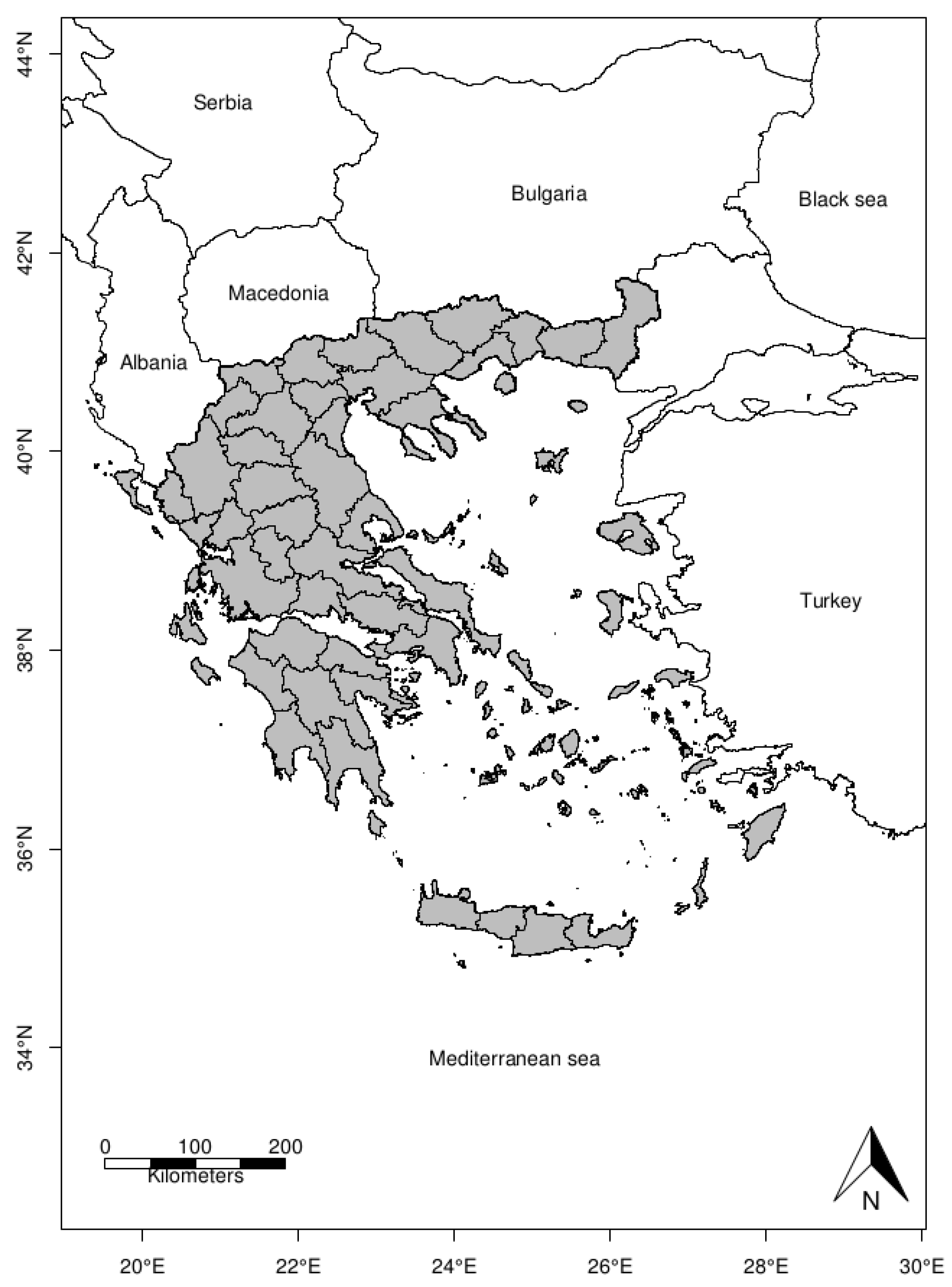
2.1. Study Area
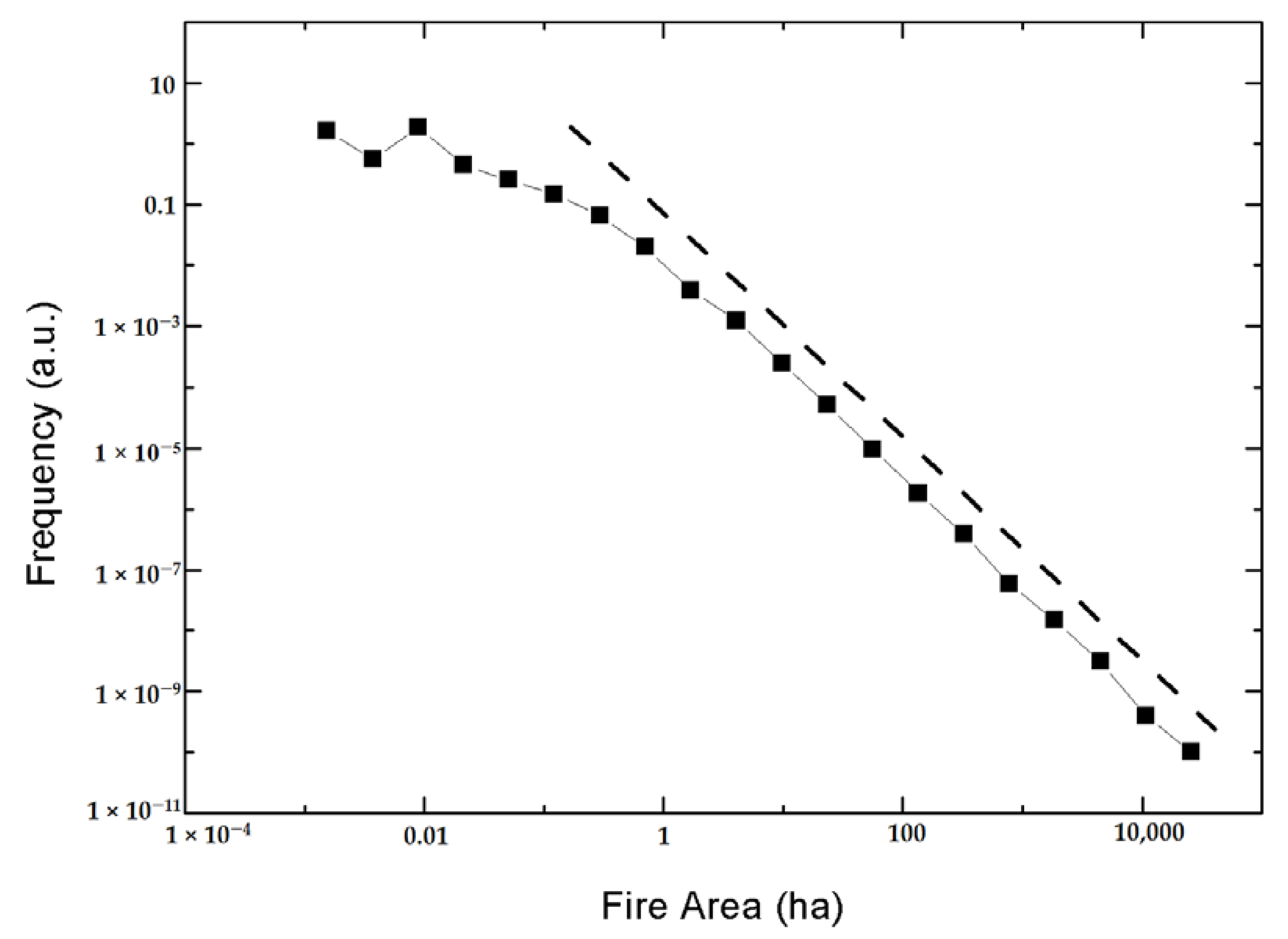
2.2. Data from Wildfires
2.3. Statistical Analysis
3. Results and Discussion
3.1. Basic Statistics
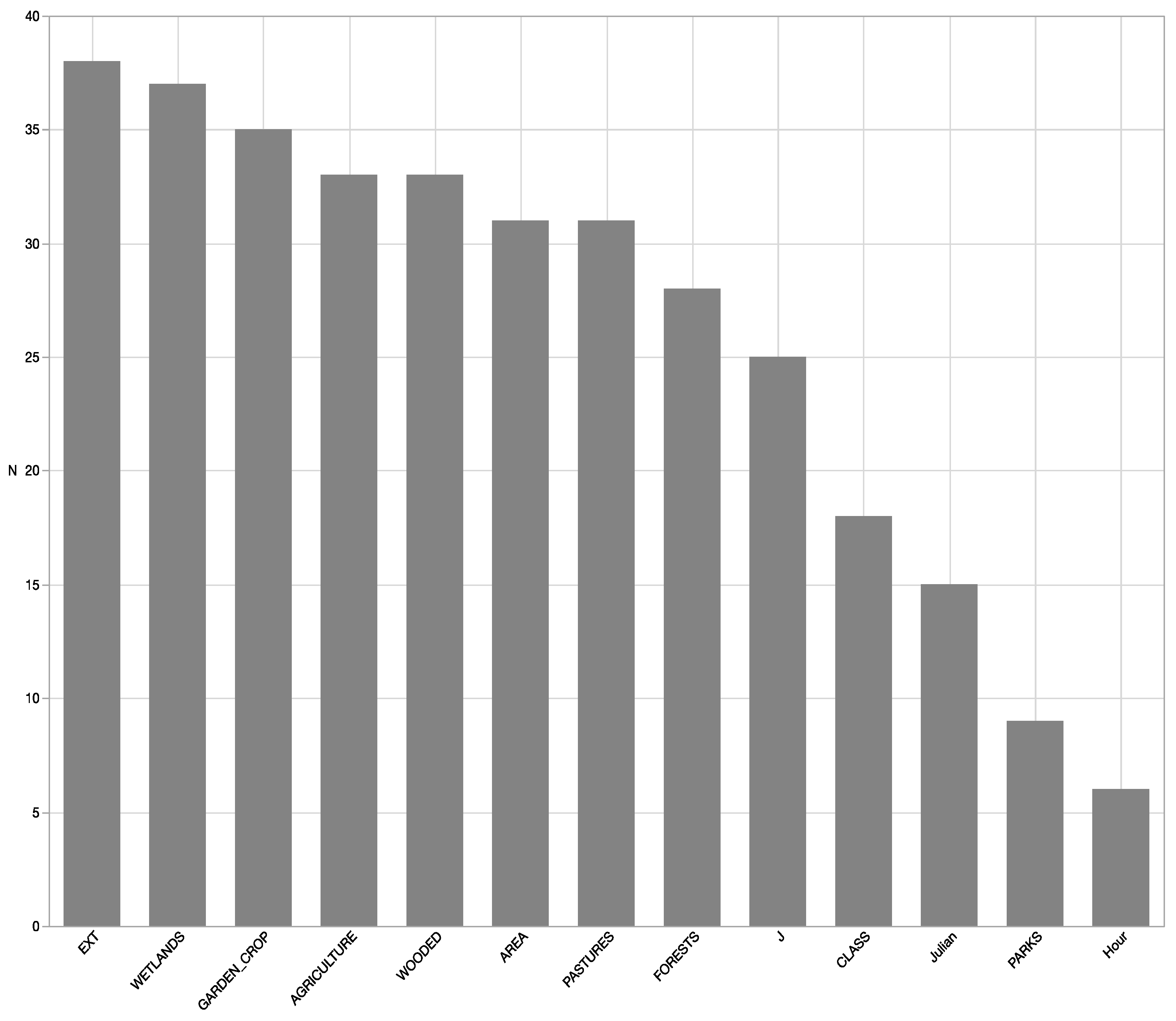
3.2. Linear Discriminant Analysis (LDA)
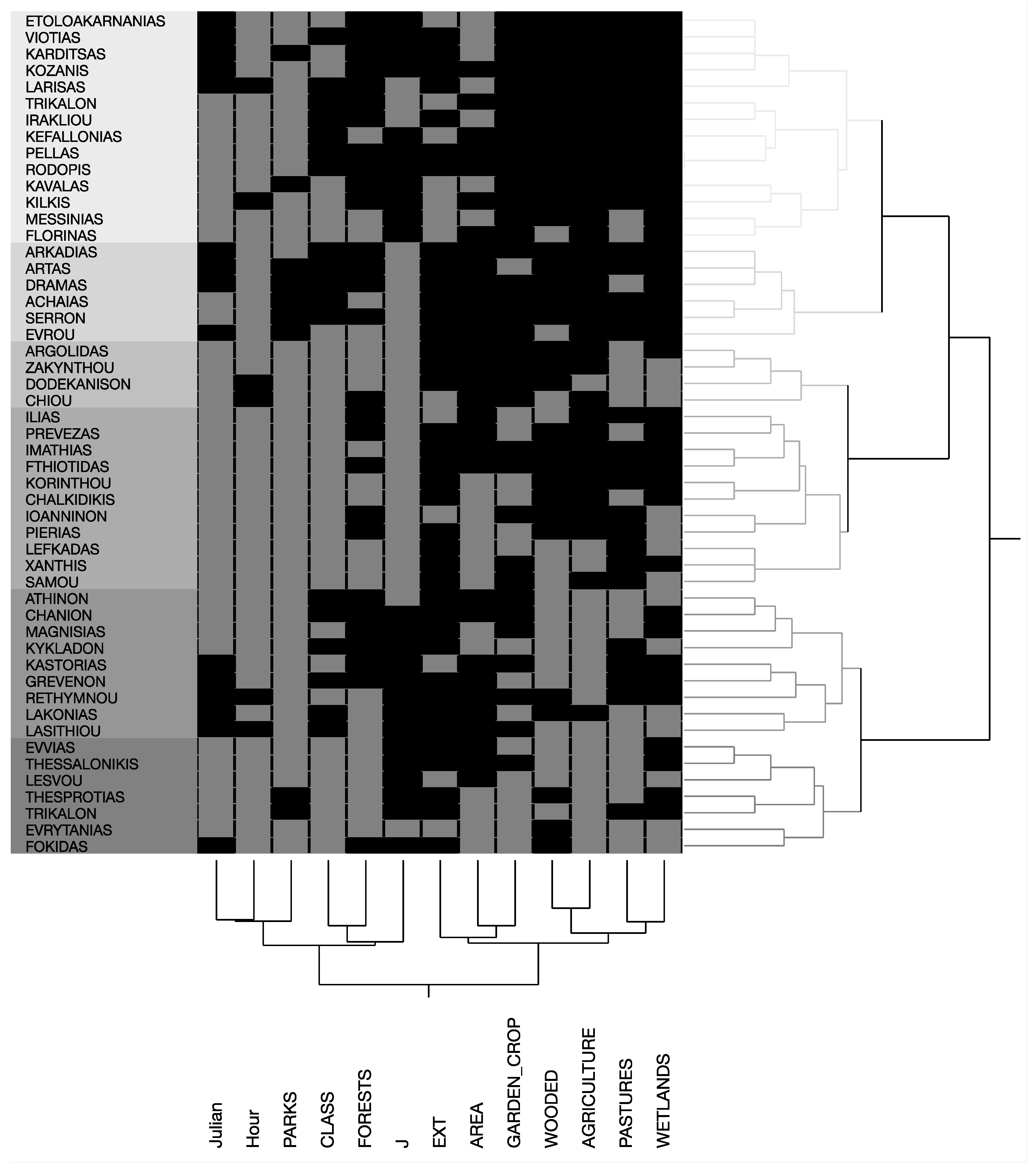
3.3. Hierarchical Clustering
3.4. Wildfire Regimes before and during the 2007 Recession
4. Conclusions
Supplementary Materials
Author Contributions
Funding
Acknowledgments
Conflicts of Interest
References
- Corona, P.; Ascoli, D.; Barbati, A.; Bovio, G.; Colangelo, G.; Elia, M.; Garfì, V.; Iovino, F.; Lafortezza, R.; Leone, V.; et al. Integrated forest management to prevent wildfires under Mediterranean environments. Ann. Silvic. Res. 2015, 39, 1–22. [Google Scholar] [CrossRef]
- Keeley, J.E. Fire intensity, fire severity and burn severity: A brief review and suggested usage. Int. J. Wildland Fire 2009, 18, 116–126. [Google Scholar] [CrossRef]
- Keeley, J.E. Fire in Mediterranean Ecosystems: Ecology, Evolution and Management; Cambridge University Press: Cambridge, UK; New York, NY, USA, 2012; ISBN 978-1-139-16080-3. [Google Scholar]
- Bond, W.J.; van Wilgen, B.W. Fire and Plants; Population and Community Biology Series; Springer: Amsterdam, The Netherlands, 1996; ISBN 978-0-412-47540-5. [Google Scholar]
- Chiriacò, M.; Perugini, A.L.; Cimini, A.D.; D’Amato, B.E.; Valentini, R.; Bovio, G.; Corona, P.; Barbati, A. Comparison of approaches for reporting forest fire-related biomass loss and greenhouse gas emissions in southern Europe. Int. J. Wildland Fire 2013, 22, 730–738. [Google Scholar] [CrossRef]
- Jacobson, M.Z. Effects of biomass burning on climate, accounting for heat and moisture fluxes, black and brown carbon, and cloud absorption effects: Effects of biomass burning on climate. J. Geophys. Res. Atmos. 2014, 119, 8980–9002. [Google Scholar] [CrossRef]
- Pyne, S.J.; Andrews, P.L.; Laven, R.D. Introduction to Wildland Fire; Wiley: Hoboken, NJ, USA, 1996. [Google Scholar]
- Kasischke, E.S.; Christensen, N.L.; Stocks, B.J. Fire, Global Warming, and the Carbon Balance of Boreal Forests. Ecol. Appl. 1995, 5, 437–451. [Google Scholar] [CrossRef]
- Levine, J.S. Biomass Burning and Global Change: Remote Sensing, Modeling and Inventory Development, and Biomass Burning in Africa; MIT Press: Cambridge, MA, USA, 1996; ISBN 978-0-262-12201-6. [Google Scholar]
- Chergui, B.; Fahd, S.; Santos, X.; Pausas, J.G. Socioeconomic Factors Drive Fire-Regime Variability in the Mediterranean Basin. Ecosystems 2018, 21, 619–628. [Google Scholar] [CrossRef]
- Tedim, F.; Xanthopoulos, G.; Leone, V. Chapter 5—Forest Fires in Europe: Facts and Challenges. In Wildfire Hazards, Risks and Disasters; Shroder, J.F., Paton, D., Eds.; Elsevier: Oxford, UK, 2015; pp. 77–99. ISBN 978-0-12-410434-1. [Google Scholar]
- Salvati, L.; Zitti, M. Land degradation in the Mediterranean Basin: Linking bio-physical and economic factors into an ecological perspective. Ital. J. Agron. 2005, 6, 67–77. [Google Scholar]
- Munafò, M.; Salvati, L.; Zitti, M. Estimating soil sealing rate at national level—Italy as a case study. Ecol. Indic. 2013, 26, 137–140. [Google Scholar] [CrossRef]
- Carlucci, M.; Grigoriadis, E.; Rontos, K.; Salvati, L. Revisiting a Hegemonic Concept: Long-term ‘Mediterranean Urbanization’ in Between City Re-polarization and Metropolitan Decline. Appl. Spat. Anal. Policy 2016, 10. [Google Scholar] [CrossRef]
- Cuadrado-Ciuraneta, S.; Guimerà, A.; Salvati, L. Not only tourism: Unravelling suburbanization, second-home expansion and “rural” sprawl in Catalonia, Spain. Urban Geogr. 2016, 38, 1–24. [Google Scholar] [CrossRef]
- Jappiot, M.; Gonzalez-Olabarria, J.R.; Lampin-Maillet, C.; Borgniet, L. Assessing Wildfire Risk in Time and Space. In Living with Wildfires: What Science Can Tell Us. A Contribution to the Science-Policy Dialogue; European Forest Institute: Joensuu, Finland, 2009; pp. 41–47. [Google Scholar]
- Sebastián-López, A.; Salvador-Civil, R.; Gonzalo-Jiménez, J.; SanMiguel-Ayanz, J. Integration of socio-economic and environmental variables for modelling long-term fire danger in Southern Europe. Eur. J. For. Res. 2008, 127, 149–163. [Google Scholar] [CrossRef]
- Bajocco, S.; Salvati, L.; Ricotta, C. Land degradation versus fire: A spiral process? Prog. Phys. Geogr. Earth Environ. 2011, 35, 3–18. [Google Scholar] [CrossRef]
- Salvati, L.; Petitta, M.; Ceccarelli, T.; Perini, L.; Battista, F.D.; Scarascia, M.E.V. Italy’s renewable water resources as estimated on the basis of the monthly water balance. Irrig. Drain. 2008, 57, 507–515. [Google Scholar] [CrossRef]
- Salvati, L.; Carlucci, M. The economic and environmental performances of rural districts in Italy: Are competitiveness and sustainability compatible targets? Ecol. Econ. 2011, 70, 2446–2453. [Google Scholar] [CrossRef]
- Salvati, L.; Zitti, M. Monitoring vegetation and land use quality along the rural–urban gradient in a Mediterranean region. Appl. Geogr. 2012, 32, 896–903. [Google Scholar] [CrossRef]
- Cissel, J.H.; Swanson, F.J.; Weisberg, P.J. Landscape Management Using Historical Fire Regimes: Blue River, Oregon. Ecol. Appl. 1999, 9, 1217. [Google Scholar] [CrossRef]
- Cochrane, M.A. Fire science for rainforests. Nature 2003, 421, 913–919. [Google Scholar] [CrossRef] [PubMed]
- Rego, F.; Silva, J. Wildfires and landscape dynamics in Portugal: A regional assessment and global implications. For. Landsc. Glob. Chang. 2014, 51–73. [Google Scholar] [CrossRef]
- Henderson, M.; Kalabokidis, K.; Marmaras, E.; Konstantinidis, P.; Marangudakis, M. Fire and Society: A Comparative Analysis of Wildfire in Greece and the United States. Hum. Ecol. Rev. 2005, 12, 169–182. [Google Scholar]
- Salvati, L.; Perini, L.; Sabbi, A.; Bajocco, S. Climate Aridity and Land Use Changes: A Regional-Scale Analysis. Geogr. Res. 2012, 50, 193–203. [Google Scholar] [CrossRef]
- Colantoni, A.; Mavrakis, A.; Sorgi, T.; Salvati, L. Towards a ‘polycentric’ landscape? Reconnecting fragments into an integrated network of coastal forests in Rome. Rendiconti Lincei 2015, 26, 615–624. [Google Scholar] [CrossRef]
- Pili, S.; Grigoriadis, E.; Carlucci, M.; Clemente, M.; Salvati, L. Towards sustainable growth? A multi-criteria assessment of (changing) urban forms. Ecol. Indic. 2017, 76, 71–80. [Google Scholar] [CrossRef]
- Salvati, L.; Serra, P. Estimating Rapidity of Change in Complex Urban Systems: A Multidimensional, Local-Scale Approach. Geogr. Anal. 2016, 48, 132–156. [Google Scholar] [CrossRef]
- Duvernoy, I.; Zambon, I.; Sateriano, A.; Salvati, L. Pictures from the other side of the fringe: Urban growth and peri-urban agriculture in a post-industrial city (Toulouse, France). J. Rural Stud. 2018, 57, 25–35. [Google Scholar] [CrossRef]
- You, W.; Lin, L.; Wu, L.; Ji, Z.; Yu, J.; Zhu, J.; Fan, Y.; He, D. Geographical information system-based forest fire risk assessment integrating national forest inventory data and analysis of its spatiotemporal variability. Ecol. Indic. 2017, 77, 176–184. [Google Scholar] [CrossRef]
- Modugno, S.; Balzter, H.; Cole, B.; Borrelli, P. Mapping regional patterns of large forest fires in Wildland–Urban Interface areas in Europe. J. Environ. Manag. 2016, 172, 112–126. [Google Scholar] [CrossRef] [PubMed]
- Bar Massada, A.; Radeloff, V.C.; Stewart, S.I.; Hawbaker, T.J. Wildfire risk in the wildland–urban interface: A simulation study in northwestern Wisconsin. For. Ecol. Manag. 2009, 258, 1990–1999. [Google Scholar] [CrossRef]
- Salvati, L.; Ferrara, A. Do Land Cover Changes Shape Sensitivity to Forest Fires in peri-urban Areas? Urban For. Urban Green. 2014, 13, 571–575. [Google Scholar] [CrossRef]
- Moreira, F.; Viedma, O.; Arianoutsou, M.; Curt, T.; Koutsias, N.; Rigolot, E.; Barbati, A.; Corona, P.; Vaz, P.; Xanthopoulos, G.; et al. Landscape–wildfire interactions in Southern Europe: Implications for landscape management. J. Environ. Manag. 2011, 92, 2389–2402. [Google Scholar] [CrossRef] [PubMed] [Green Version]
- Salvati, L. Profiling forest fires along the urban gradient: A Mediterranean case study. Urban Ecosyst. 2014, 17, 1175–1189. [Google Scholar] [CrossRef]
- Bajocco, S.; Rosati, L.; Ricotta, C. Knowing fire incidence through fuel phenology: A remotely sensed approach. Ecol. Model. 2010, 59–66. [Google Scholar] [CrossRef]
- Fares, S.; Bajocco, S.; Salvati, L.; Camarretta, N.; Dupuy, J.; Xanthopoulos, G.; Guijarro, M.; Madrigal, J.; Hernando, C.; Corona, P. Characterizing potential wildland fire fuel in live vegetation in the Mediterranean region. Ann. For. Sci. 2017, 74. [Google Scholar] [CrossRef] [Green Version]
- Salvati, L.; Zitti, M.; Ceccarelli, T. Integrating economic and environmental indicators in the assessment of desertification risk: A case study. Appl. Ecol. Environ. Res. 2007, 6. [Google Scholar] [CrossRef]
- Koutsias, N.; Arianoutsou, M.; Kallimanis, A.S.; Mallinis, G.; Halley, J.M.; Dimopoulos, P. Where did the fires burn in Peloponnisos, Greece the summer of 2007? Evidence for a synergy of fuel and weather. Agric. For. Meteorol. 2012, 156, 41–53. [Google Scholar] [CrossRef]
- Salvati, L.; Morelli, V.G.; Rontos, K.; Sabbi, A. Latent Exurban Development: City Expansion Along the Rural-To-Urban Gradient in Growing and Declining Regions of Southern Europe. Urban Geogr. 2013, 34, 376–394. [Google Scholar] [CrossRef]
- Karamesouti, M.; Detsis, V.; Kounalaki, A.; Vasiliou, P.; Salvati, L.; Kosmas, C. Land-use and land degradation processes affecting soil resources: Evidence from a traditional Mediterranean cropland (Greece). CATENA 2015, 132, 45–55. [Google Scholar] [CrossRef]
- Kosmas, C.; Karamesouti, M.; Kounalaki, K.; Detsis, V.; Vassiliou, P.; Salvati, L. Land degradation and long-term changes in agro-pastoral systems: An empirical analysis of ecological resilience in Asteroussia—Crete (Greece). CATENA 2016, 147, 196–204. [Google Scholar] [CrossRef]
- Xanthopoulos, G.; Caballero, D.; Galante, M.; Alexandrian, D.; Rigolot, E.; Marzano, R. Forest Fuels Management in Europe. In Proceedings of the Fuels Management—How to Measure Success, Portland, OR, USA, 28–30 March 2006; Andrews, P.L., Butler, B.W., Eds.; USDA Forest Service: Fort Collins, CO, USA, 2006; pp. 29–46. [Google Scholar]
- Mika, S.; Ratsch, G.; Weston, J.; Scholkopf, B.; Mullers, K.R. Fisher discriminant analysis with kernels. In Proceedings of the 1999 IEEE Signal Processing Society Workshop (Cat. No.98TH8468) on Neural Networks for Signal Processing IX, Madison, WI, USA, 25 August 1999; pp. 41–48. [Google Scholar] [Green Version]
- Ceccarelli, T.; Bajocco, S.; Luigi Perini, L.; Luca Salvati, L. Urbanisation and Land Take of High Quality Agricultural Soils—Exploring Long-term Land Use Changes and Land Capability in Northern Italy. Int. J. Environ. Res. 2014, 8, 181–192. [Google Scholar] [CrossRef]
- Salvati, L. Monitoring high-quality soil consumption driven by urban pressure in a growing city (Rome, Italy). Cities 2013, 31, 349–356. [Google Scholar] [CrossRef]
- Gutenberg, B.; Richter, C.F. Frequency of earthquakes in California. Bull. Seismol. Soc. Am. 1944, 34, 185–188. [Google Scholar]
- Petri, A.; Pontuale, G. Morphology and dynamics in SOC universality classes. J. Stat. Mech. Theory Exp. 2018, 2018, 063201. [Google Scholar] [CrossRef]
- Pietronero, L.; Tosatti, E.; Tosatti, V.; Vespignani, A. Explaining the uneven distribution of numbers in nature: The laws of Benford and Zipf. Phys. A Stat. Mech. Appl. 2001, 293, 297–304. [Google Scholar] [CrossRef]
- Gabaix, X. Power Laws in Economics and Finance. Annu. Rev. Econ. 2009, 1, 255–294. [Google Scholar] [CrossRef]
- Serra, P.; Martín, A.; Tulla, A.; Salvati, L. Beyond urban–rural dichotomy: Exploring socioeconomic and land-use processes of change in Spain (1991–2011). Appl. Geogr. 2014, 55, 71–81. [Google Scholar] [CrossRef]
- Salvati, L.; Ferrara, A. Validation of MEDALUS Fire Risk Index using Forest Fires Statistics through a multivariate approach. Ecol. Indic. 2015, 48, 365–369. [Google Scholar] [CrossRef]
- Zitti, M.; Ferrara, C.; Perini, L.; Carlucci, M.; Salvati, L. Long-Term Urban Growth and Land Use Efficiency in Southern Europe: Implications for Sustainable Land Management. Sustainability 2015, 2015, 3359–3385. [Google Scholar] [CrossRef]
- de Groot, R.S.; Alkemade, R.; Braat, L.; Hein, L.; Willemen, L. Challenges in integrating the concept of ecosystem services and values in landscape planning, management and decision making. Ecol. Complex. 2010, 7, 260–272. [Google Scholar] [CrossRef]
- Barbati, A.; Corona, P.; Salvati, L.; Gasparella, L. Natural forest expansion into suburban countryside: Gained ground for a green infrastructure? Urban For. Urban Green. 2013, 12, 36–43. [Google Scholar] [CrossRef] [Green Version]
- Bajocco, S.; Dragoz, E.; Gitas, I.; Smiraglia, D.; Salvati, L.; Ricotta, C. Mapping Forest Fuels through Vegetation Phenology: The Role of Coarse-Resolution Satellite Time-Series. PLoS ONE 2015, 10, e0119811. [Google Scholar] [CrossRef] [PubMed]
- De Angelis, A.; Bajocco, S.; Ricotta, C. Phenological variability drives the distribution of wildfires in Sardinia. Landsc. Ecol. 2012, 27, 1535–1545. [Google Scholar] [CrossRef]
- Cardille, J.; Ventura, S.; Turner, M. Environmental and Social Factors Influencing Wildfires in the Upper Midwest, United States. Ecol. Appl. 2001, 11, 111–127. [Google Scholar] [CrossRef]
- Sturtevant, B.R.; Cleland, D.T. Human and biophysical factors influencing modern fire disturbance in northern Wisconsin. Int. J. Wildland Fire 2007, 16, 398–413. [Google Scholar] [CrossRef]
- Lovreglio, R.; Leone, V.; Giaquinto, P.; Notarnicola, A. Wildfire cause analysis: Four case-studies in southern Italy. IFor. Biogeosci. For. 2010, 3. [Google Scholar] [CrossRef]
- Gilless, J.K.; Fried, J.S. Stochastic representation of fire behavior in a wildland fire protection planning model for California. For. Sci. 1998, 454, 492–499. [Google Scholar]
- Biasi, R.; Colantoni, A.; Ferrara, C.; Ranalli, F.; Salvati, L. In-between sprawl and fires: Long-term forest expansion and settlement dynamics at the wildland–urban interface in Rome, Italy. Int. J. Sustain. Dev. World Ecol. 2015, 22, 467–475. [Google Scholar] [CrossRef]
- Salvati, L.; Ferrara, A.; Mancino, G.; Kelly, C.; Chianucci, F.; Corona, P. A Multidimensional Statistical Framework to Explore Seasonal Profile, Severity and Land-Use Preferences of Wildfires in a Mediterranean Country. Int. For. Rev. 2015, 17, 485–497. [Google Scholar] [CrossRef]
- Ferrara, C.; Carlucci, M.; Grigoriadis, E.; Corona, P.; Salvati, L. A comprehensive insight into the geography of forest cover in Italy: Exploring the importance of socioeconomic local contexts. For. Policy Econ. 2017, 75, 12–22. [Google Scholar] [CrossRef]
- Stratton, R.D. Guidance on Spatial Wildland Fire Analysis: Models, Tools, and Techniques; Gen Tech Rep RMRS-GTR-183; U.S. Department of Agriculture, Forest Service: Fort Collins, CO, USA, 2006; Volume 183, 15p. [CrossRef]
- Mavrakis, A.; Salvati, L. Analyzing the Behaviour of Selected Risk Indexes during the 2007 Greek Forest Fires. Int. J. Environ. Res. 2015, 9, 831–840. [Google Scholar]


| Typology | Prefectures | |
|---|---|---|
| 1 | Economically marginal rural areas with moderate-poor accessibility | Artas, Dramas, Etoloakarnanias, Evrytanias, Florinas, Fokidas, Fthiotidas, Grevenon, Ilias, Imathias, Ioanninon, Karditsas, Kastorias, Kilkis, Kozanis, Pellas, Pierias, Rodopis, Serron, Thesprotias, Xanthis |
| 2 | Agricultural regions with intermediate population density and moderate accessibility from the capital | Achaias, Argolidas, Arkadias, Evrou, Evvias, Kavalas, Korinthou, Lakonias, Lasithiou, Lefkadas, Messinias, Prevezas, Trikalon, Trikalon, Viotias |
| 3 | Areas with uneven urbanization | Athens, Iraklio, Larisa, Thessaloniki |
| 4 | Coastal, island or peninsular areas specialized in tourism sector | Chalkidikis, Chanion, Chiou, Dodekanison, Kefallonias, Kykladon, Lesvou, Magnisias, Rethymnou, Samou, Zakynthou |
| Acronym | Description |
|---|---|
| JUL | Ignition date ranging between 0 and 1 (Julian calendar day rank/365 days) |
| HOU | Ignition hour ranging between 0 and 1 |
| EXT | Wildfire’s extinguishing time per space unit (min, logarithm) |
| AREA | Average forest burnt area (ha, logarithm) |
| CLASS | Number of land-use classes affected by wildfires to burnt area |
| FORESTS | Forest burnt area in total burnt area, forest and non-forest (%) |
| WOODED | Wooded burnt area (shrubland, maquis, garigue) in total burnt area (%) |
| PARKS | Urban parks and garden burnt area in total burnt area (%) |
| PASTURES | Pastures and sparsely vegetated burnt areas in total burnt area (%) |
| WETLANDS | Riparian vegetation and residual surrounding burnt land in total burnt area (%) |
| AGRICULTURE | Agricultural burnt area in total burnt area (%) |
| GARDEN CROP | Sparse cultivation burnt area in total burnt area (%) |
| J | Pielou J Eveness Index in the statistical distribution of land-use affected by wildfires |
| Economic Typology | Wildfire Phenology | Extinguishing Time | Wildfire Size | Landscape Heterogeneity | |
|---|---|---|---|---|---|
| 1 | Economically marginal rural areas with poor accessibility | Except for Dramas, it decreases or remains nearly constant | Except for Artas and Thesprotias, it increases | Except for Karditsas, it decreases or remains constant | It increases or remains constant |
| 2 | Agricultural regions with intermediate population density and moderate accessibility from the capital city | Except for Lakonias, it decreases | Except for Evrou, it increases | Except for Karditsas, it decreases or remains constant | Except for Achaias, it increases or remains nearly constant |
| 3 | Urban areas with heavy consumption of land | Except for Athens (where it strongly decreases), it is not significant | It increases | It remains constant | It decreases or remains constant |
| 4 | Coastal, island or peninsular areas with important tourism | Except for Kykladon (where it strongly decreases), it is not significant | It increases | Except for Samou, it decreases or remains constant | Except for Kefallonias, it decreases or remains constant |
© 2018 by the authors. Licensee MDPI, Basel, Switzerland. This article is an open access article distributed under the terms and conditions of the Creative Commons Attribution (CC BY) license (http://creativecommons.org/licenses/by/4.0/).
Share and Cite
Marchi, M.; Chianucci, F.; Ferrara, C.; Pontuale, G.; Pontuale, E.; Mavrakis, A.; Morrow, N.; Rossi, F.; Salvati, L. Sustainable Land-Use, Wildfires, and Evolving Local Contexts in a Mediterranean Country, 2000–2015. Sustainability 2018, 10, 3911. https://0-doi-org.brum.beds.ac.uk/10.3390/su10113911
Marchi M, Chianucci F, Ferrara C, Pontuale G, Pontuale E, Mavrakis A, Morrow N, Rossi F, Salvati L. Sustainable Land-Use, Wildfires, and Evolving Local Contexts in a Mediterranean Country, 2000–2015. Sustainability. 2018; 10(11):3911. https://0-doi-org.brum.beds.ac.uk/10.3390/su10113911
Chicago/Turabian StyleMarchi, Maurizio, Francesco Chianucci, Carlotta Ferrara, Giorgio Pontuale, Elisa Pontuale, Anastasios Mavrakis, Nathan Morrow, Fabrizio Rossi, and Luca Salvati. 2018. "Sustainable Land-Use, Wildfires, and Evolving Local Contexts in a Mediterranean Country, 2000–2015" Sustainability 10, no. 11: 3911. https://0-doi-org.brum.beds.ac.uk/10.3390/su10113911