Time, Cognition, and Approach: Sustainable Tourism Strategies for Abandoned Vernacular Landscapes

1
Department of Mechanical Engineering and Construction, Universitat Jaume I, 12071 Castelló de la Plana, Spain
2
School of Architecture, Universitat Politècnica de València, 46022 València, Spain
*
Author to whom correspondence should be addressed.
Sustainability 2018, 10(8), 2712; https://0-doi-org.brum.beds.ac.uk/10.3390/su10082712
Submission received: 21 June 2018
/
Revised: 25 July 2018
/
Accepted: 30 July 2018
/
Published: 1 August 2018
(This article belongs to the Special Issue Challenges and Opportunities for Sustainable Tourism)
Abstract
:The main objective of the study is to challenge previous approaches to heritage, both in terms of management and conceptualization. It aims to highlight the importance and articulation of the different attributes in abandoned vernacular landscapes in search of a sustainable approach. To do so, the study focuses on a specific landscape in the Mediterranean basin where three areas of intensity have been selected for an eventual assessment of the principles of integration and consistency of the landscape. These areas have helped to establish the importance of distance and cognition in determining strategies for sustainable tourism. Geographic Information Systems (GIS) have allowed us to ascertain the extent to which values, previously acquired from participatory fieldwork, can be detected depending on proximity or remoteness, as well as their application in the three cases for assessment. Thus, five criteria have been established to analyse these values: (1) overview of the landscape, (2) dominance or intensity of elements, (3) the aesthetic composition of space, (4) the selective interpretation of the visual variables, and (5) the fragility of specific areas in the landscape. Finally, the discussed criteria provide new insights into the dynamic and static realms of authenticity and integrity, which have helped in the analysis of previous rigid conventions on values, time, perception, and approach.
1. Introduction
The classic definition provided by Higgins-Desbiolles [1] through Butler [2] focuses on “tourism that is in a form that can maintain its viability in an area for an indefinite period of time”. This definition is essential in order to fully grasp the extent of stagnation found in rural areas of the Mediterranean, such as in the case study presented here. Equally, sustainable tourism, as Ruhanen [3] explains in reference to Wesley and Pforr [4], is based on the need for political and economic change that balances ecological, economic, and sociocultural aspects in order to move towards more appropriate forms of tourism development.
Connotations of sustainable environments rely on specific aspects of places, including population volume, the division of different local, regional or national actors, and how they assume the responsibility that results from attempts to balance the concepts of ecology, economy, and socialization of spaces. The stake which most parties, including local government institutions, have in tourism development planning, even though they are not tourism institutions [5], further complicates understanding of this relationship.
Snowdon et al. [6] define different intensities of tourism, ranging from mild to strong. These intensities are important in tackling the impact of unsustainable growth strategies including colonization of spaces and excess cargo capacity, as well as the depletion of resources and unequal development. Tourism, far from the clichés of economic growth or the repopulation of abandoned areas, requires the purpose and meaning of conscious and responsible actions to be questioned metaphysically. In this case, tourism can be a facilitator for education, intercultural commitment, ecological appreciation, intellectual development, and the transmission of values and cultures.
Initially, cultural tourism was an alternative form of tourism to mass tourism. Stebbins [7] defined cultural tourism as a kind of tourism of special interest based on the search and participation in new and profound cultural experiences, whether aesthetic, intellectual, emotional, or psychological. Cultural tourism currently focuses on integrating production and consumption, while increasing links between suppliers and consumers. Instead of passive consumption, cultural tourists exercise a proactive approach in order to satisfy and respect needs, and to actively participate in the creation of experiences during visits [8]. This sometimes calls for the commodification of cultural heritage, in turn revealing a “real” experience that is defined as authentic, original, and local.
There is growing concern among visitors regarding the authenticity of ecological and cultural tourism practices when intellectually, culturally, and environmentally assessing remote regions [9]. Quality tourism, which is supposed to be sustainable and durable over time, tends to shun mediocre, damaged, and homogenized landscapes, searching for original, authentic, aesthetically pleasing, and well-groomed landscapes.
Matsuoka and Kaplan [10] spoke of the personal preference for natural and partially anthropized environments over urban ones. This choice also depends on the natural, agricultural, cultural, symbolic, or historic significance of these environments, together with their encompassing activities and social realities. In this way, some contexts result in so-called “scenic beauty” aesthetic experiences, while others prompt different emotional experiences, such as perceived attention, attachment, and identity [11].
Although appreciation of the landscape is inherently dependent on subjective preferences, perception can only be referenced if the elements at stake are objectified. Therefore, viewing perception as the ability of landscapes to communicate results in an objectivity that is dependent on knowledge and cultural immersion.
Some studies focus on how the landscape can communicate through its values. Fredheim and Khalaf [12] reviewed the literature on values, arguing that a systematic lack of flexibility prevents values from being fully understood. They defended the dynamism of values through changes in perception. Providing values are conceived as social constructs [13], the concepts of integrity and authenticity are also accepting of new perspectives that affect the cognition of places [14,15], especially abandoned vernacular landscapes.
The International Council of Monuments and Sites (ICOMOS) [16] recently recognized dynamic physical changes and material absence as inherent to specific landscapes. These processes are considered intrinsic progressions of contemporary vernacular landscapes. Authenticity is therefore linked to truthfulness and the preservation of functions and meanings [17]. Although it should be borne in mind that expectations of authenticity are somewhat contentious, the industry can provide this authenticity without commodifying the individual attractions and stimulating consumer's experiences through recognition and habituation [18]. Tourist notions of authenticity are largely driven by the connection and association with the quality of the experience, and do not necessarily fit strict criteria of truthfulness or falsehood [19].
In places such as these, heritage provides social and cultural “representation” experiences in which people actively participate [20]. It is also argued that despite places having innate characteristics that may lack cultural significance [21], individuals tend to recognize values based on their own expectations or desires, shaping them according to their social, cultural, or economic circumstances [22]. Values associated to certain landscapes are not innate qualities in themselves. Instead, the context, the fabric, the object, or the medium are the carriers of imposed meanings, specifically natural, cultural, or historical meanings, determined in terms of the perceptual frames of certain eras [23].
Therefore, cognition cannot be dissociated from the approach and time in which the observer lives. Perception is conditioned by previous knowledge, experience, and the subsequent judgments of the individual. Perception and aesthetic appreciation of landscapes rely on many factors, some of which are common and fixed in time and space. Some factors are determined by the social context in which the tourist lives, while others are linked to experiences acquired over time.
Nassauer [24] suggests that the visible evidence of care and attention to the landscape evokes an aesthetic response that makes the viewer feel good. Land management no longer has the sole purpose of producing economic benefits, and instead it responds to the multifunctional needs of society, such as recreation and quality of life. Domon [25] highlights how earlier landscapes were appreciated based on their ability to produce goods, whereas the appreciation of rural spaces currently depends on the decisive factors of aesthetic, environmental, and heritage qualities.
As a result of this, the term “design” is used to define the “intentional change of the landscape” [26]. What is most striking about these changes, usually linked to tourism development or the management of natural resources, is that they can condition the lives of local residents. Therefore, design strategies including dynamization, homogenization, and fossilization need to be examined in depth from different perspectives.
In keeping with the above, it should be mentioned that the key concept of temporality [27] contributes to the understanding of abandoned vernacular landscapes. Spaces carry scars in the form of disruptions (e.g., abandonment) that can be of use in identifying and confirming the different strata of their cultural and natural evolution [28]. Over time, the development of this landscape is expressed by its temporary, continuous, and linear nature, which allows visitors to glimpse different periods or ages. As will be further analysed, values should not be based on static attributes alone, but also on dynamic ones that show how landscapes evolve and continue to evolve over time [29].
With this in mind, we will pursue novel insights into abandoned vernacular landscapes:
- An approach that helps design sustainable tourism interactions in fragile landscapes.
- Establishing an understanding while respecting the existing values of fragile landscapes.
2. Materials and Methods
2.1. Area of Study
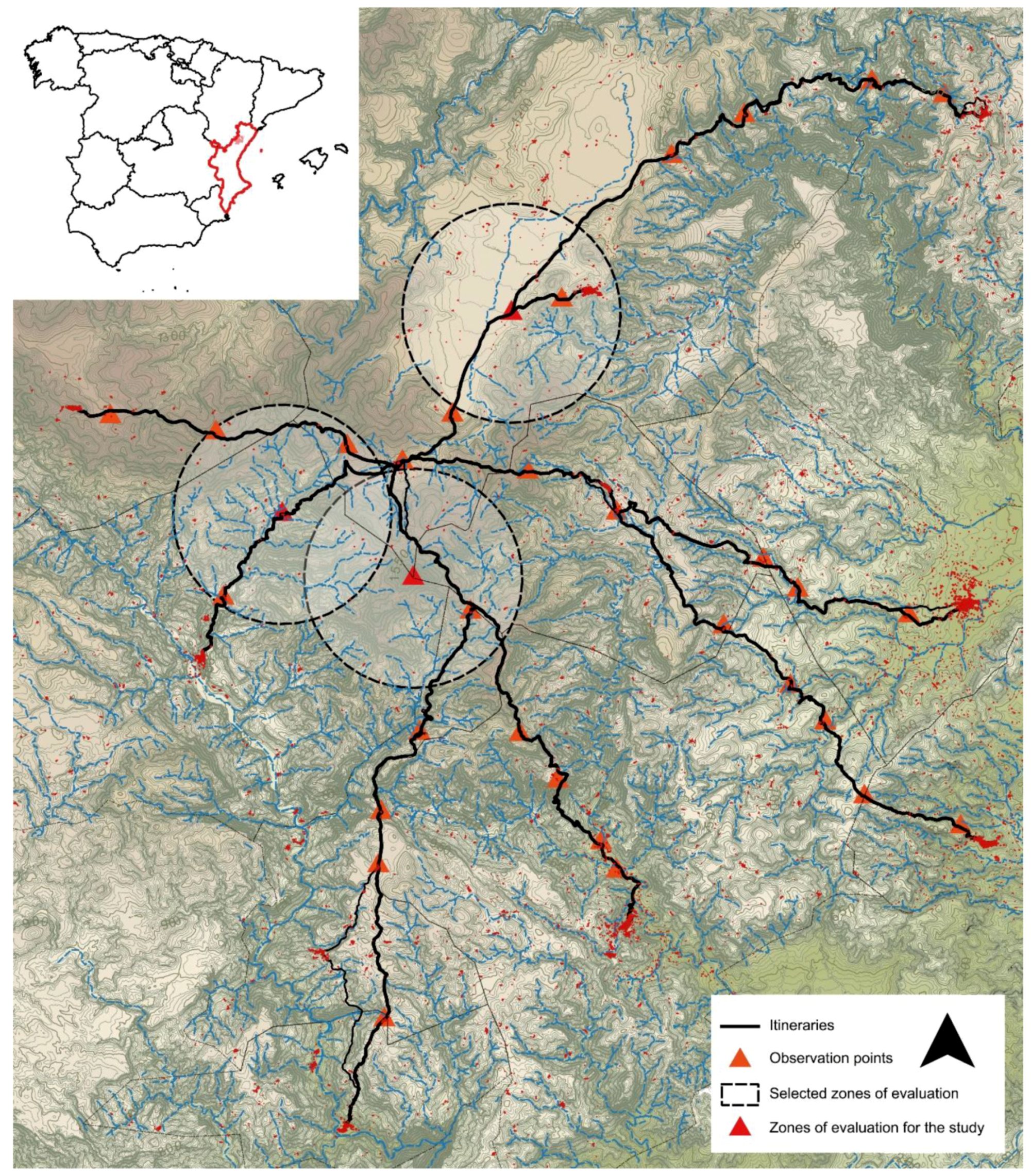
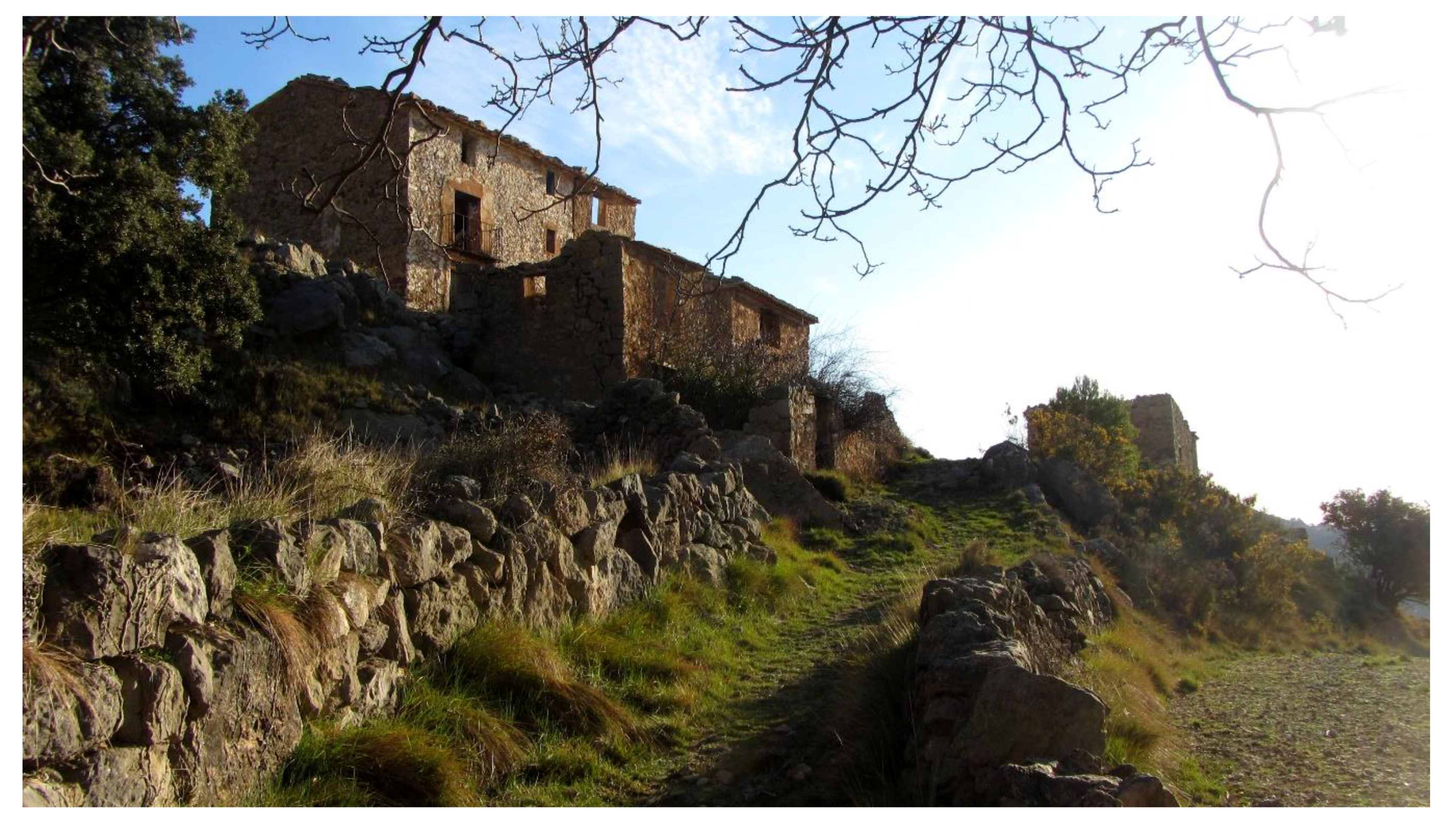
This study was carried out on Penyagolosa Mountain and its area of influence, in Castellón, Spain (Figure 1). The surface area, 288 km2, ranges from 400 to 1800 meters in altitude. These variations condition the climate to produce four different bioclimatic layers depending on altitude and orientation, generating a highly biodiverse natural environment, bordered by mountain ranges, ravines, and a few plateaus [30]. The municipalities found near this mountain experience the consequences of a strong migration to large urban nuclei [31,32]. Therefore, current loss of population, together with the relative abandonment of this type of pseudo-indigenous rural life [14], not only poses a relative threat to specific preservation criteria, but also sets interesting challenges for the economic, cultural, and environmental viability of the place (Figure 2) [33].
Extensive fieldwork was carried out in order to provide a wealth of information for the GIS analysis. As output, authors established six important phases or strata of transformation from different periods:
- The Moorish period: Before the 13th century, the area under study was populated by Moors. Although there are no material remains, methods for cultivation, settlement, and irrigation have been preserved.
- The Christian conquest: The living system, as it is known today, began in the first third of the 13th century. Farmhouses and hermitages were built and pilgrimages became popular. Although scarce, some remains from this period can be found in the area under study.
- Livestock: From the 13th to the 18th century, the main activity in the area was livestock. Inherited farmyards, gullies, trails, fountains, and territorial divisions for cattle enclosure can still be found in the landscape.
- Agriculture: From the 18th century on, socioeconomic change caused agriculture to become the main activity in the area. From then on, farmhouses and terraces for crops took shape on the mountain slopes, while the new landscapes were shaped by forest usage and the commercialization of goods.
- The exodus: The beginning of the 20th century saw the population in the area, both scattered and in small hamlets, peak. Nonetheless, rural exodus to cities increased between the 1940s and 1970s.
- The rediscovery of nature: Although hiking has always been a popular activity in the area, current processes are increasingly focused on social values and rural tourism, leading to changes in the management of heritage spaces.
All these stages provide a rich anthropized landscape with countless heritage sources. Currently, this landscape combines mostly natural resources with scattered architecture in deteriorating condition.
According to ICOMOS [34], integrity was first acknowledged in earlier considerations relating to visual importance. Unless they were intrinsically diverse, World Heritage properties were forced to respond to dynamic changes and threats through buffer zones. Nonetheless, this stance raises questions as to whether different approaches are valid instruments for safeguarding diverse heritage. This was seemingly the first time in which specificities of regions and diverse approaches were discussed for buffer zones. Concepts related to zoning, or excessive control, as processes that inevitably replace existing social, cultural, and economic diversity were examined. In keeping with this, the Council of Europe (2006) discussed the application of integration and consistency principles to Landscape Sustainability [35] to prevent the creation of parallel realities or heterotopias and policies at odds in the search for preserving diversity and distinctive features [36,37]. Based on the above, this research presents new formulas for rethinking the concept of buffer zones and concepts relating to authentic diverse heritage, seeking to integrate sustainable tourism into abandoned vernacular landscapes.
2.2. Method: The Design of a Sustainable Approach
2.2.1. Assessment of the Landscape
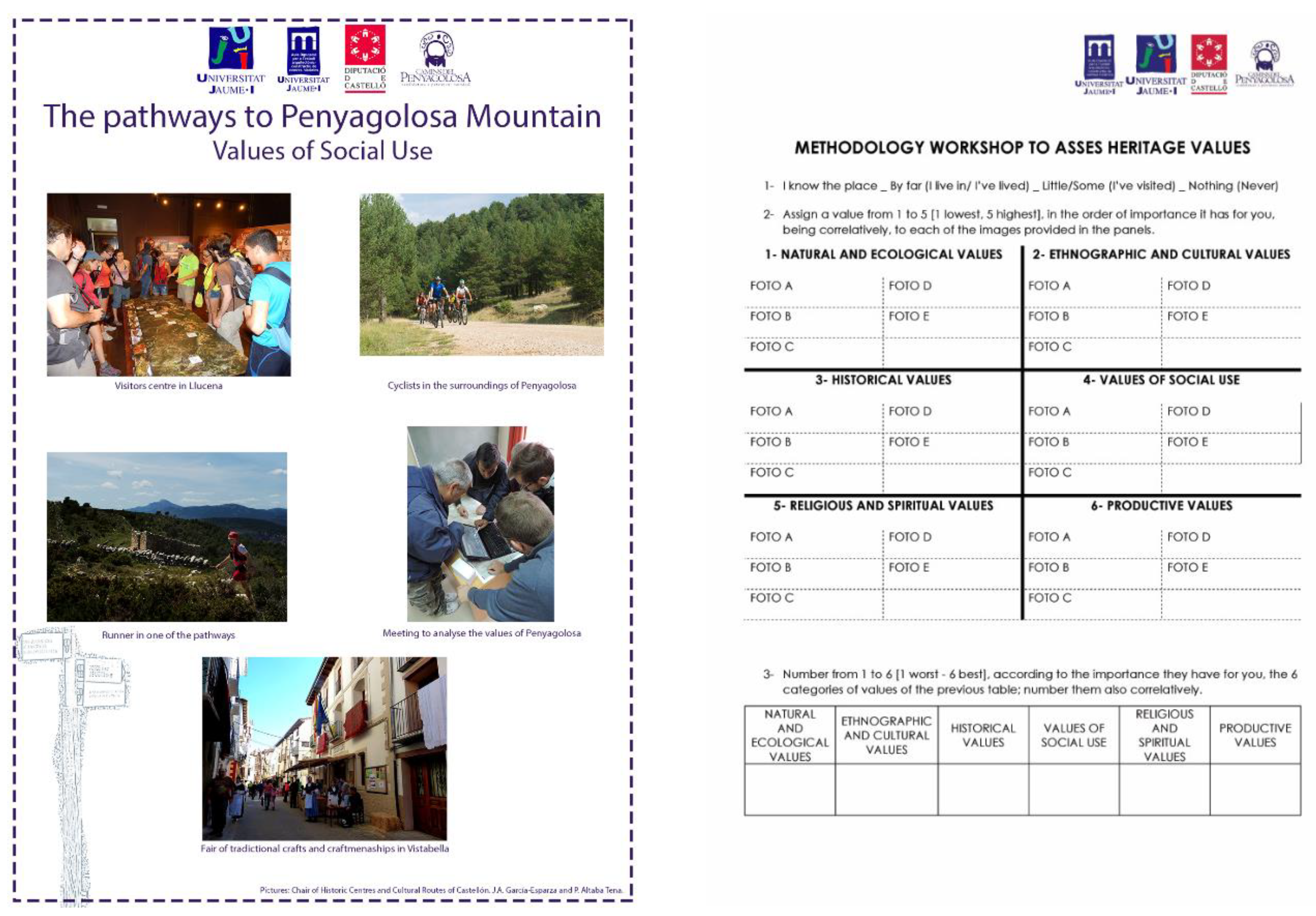
One of the aims of the research was to bring together experts and residents. Although the collaborations between locals and academics did cause some tension [38] due to differing interpretations of the same territory, it still appears to be the best possible form of analysis. For this reason, the introductory topics were examined jointly in order to establish common starting points regarding global landscape-heritage concepts. Cultural participation, despite disagreements, ensures inclusive transversal relationships between experts and citizens, thanks to the deliberate identification and assessment of the sociocultural, economic, and environmental interactions that make up the landscape [39]. Therefore, participation is not used as a shield or a mere validation method without further consequences [40].
Many institutions, associations, and researchers have revealed the unique characteristics of landscape and heritage. Recent examples of these assessments include the proposals from English Heritage [41], assigning four different types of value ranges: proof value, historic value, aesthetic value, and communal value. In contrast, another hypothesis attempting to focus on the theory of values was implemented by Stephenson [42] in the Cultural Values Model, which divided heritage into form, relationships, and practices. Other methods proposed focus primarily on the stories, later examining importance before going on to focus on other locations [43]. The aim is to work on the tangible and intangible nature of landscapes as basic points in order to interpret them through an “authorized” classification [44]. The evaluation proposed by Speed et al. [45] should also be taken into consideration, with a detailed comparison and individual and joint analysis of differences in the integration and assessment of natural and cultural values. Finally, Harrison [46] speaks of dialogical heritage models that lead to a more fluid examination of the relationship between heritage and other social, political, and environmental matters. These models do not necessarily view the different fields as separate, and instead see them as interconnected at the most basic and complex levels.
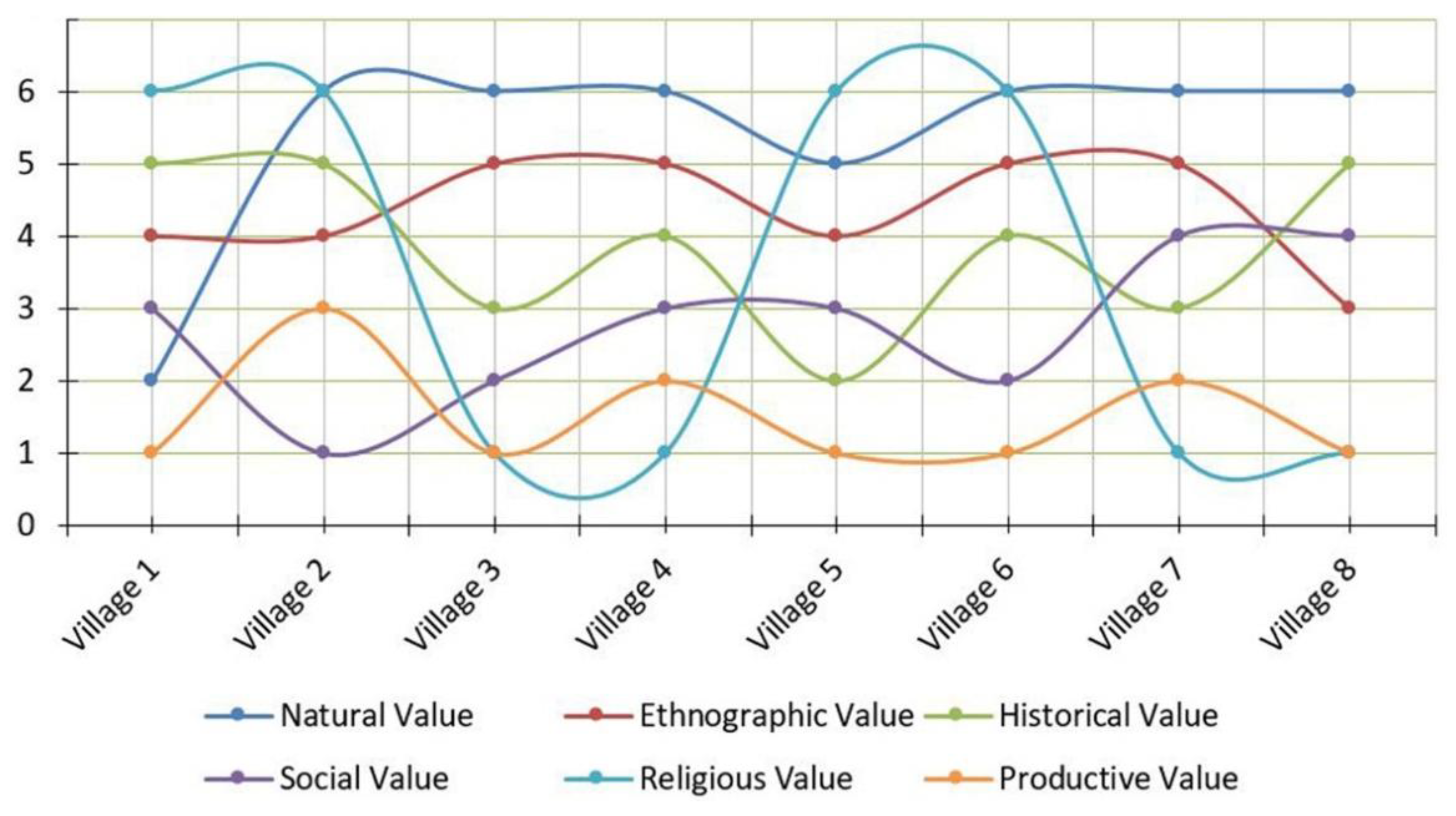
Using the photo-elicitation mentioned earlier and the incorporation of landscape values (Figure 3 and Figure 4), it was proposed to catalogue their importance based on the value attached. Natural values were recognized as the most important, followed by ethnographic values. Historic values and social values obtained similar results, with production values considered the least important. Paradoxically, in the surveys for most municipalities, the production value that configured the rural space under study came last. Nevertheless, there is a value that depends on the secular tradition of making pilgrimages, out of necessity and faith—praying for rain, health and peace—to the church of Penyagolosa. The municipalities that still observe these traditions consider religious value to be the most important. In contrast, in villages where pilgrimages are no longer practiced this value comes in last place.
One of the main characteristics of the landscape is that it is better understood and appreciated when all the values are combined. These value typologies enhance or delegitimize certain values to the benefit of others [47], and as a result they are neglected and eventually forgotten.
2.2.2. Evaluation of Areas of Intensity Using GIS
Many methodologies, including those developed by Stephenson [42], Swanwick [48], Tudor [49], and Wagtendonk and Vermaat [50], assess the tourist experience in any given landscape or historic building [51]. The procedure uses participation in order to obtain better approximations to the anthropic elements found in the landscape, translating them cartographically like Brown and Fagerholm [52] and Brown, Weber and de Bie [53]. Photographs from strategic locations have been assessed based on the models developed by Tempesta [54], Stewart et al. [55], and Dupont et al. [56]. The use of photographic analysis, Geographic Information Systems (GIS) and analytical studies on the perception of the elements contained in each position on these routes have followed the work of Martin et al., and Chamberlain and Meitner [57,58]. Finally, mathematical models integrated into GIS software ensured a better adaptation of the visual basins in digital terrain models [59].
This study has shown participatory processes to be useful in managing the landscape as a run-up to a touristization process, while the article aims to provide an objective view of the elements that might define the tourist experience. In this case, GIS tools are used to graphically display the scope of objective perception of the landscape at different distances from certain places that need to be respected according to inhabitants’ wishes.
The different points of observation in the area of study can be seen in Figure 1. These points—places of intangible values, unique buildings, culturally significant geographical locations, and major river basins or itineraries of considerable historical, natural, or cultural interest—are very important to the local population.
After workshops, researchers analyzed how those assets would be better represented. In this respect, given a piece of land and a point of view, the main problem of visibility lay in the analysis of the visual basin, the elements, and portion of terrain that were perceptible from that point. The analysis required altimetry information, as this was the only data that allowed the zones that can be classified in a range of intensities to be theoretically mapped. In the raster models, the altimetry was connected to the center of each cell and, by extension, to its entire surface. Consequently, the minimum unit of information was the cell, and Visible/Non-Visible values were assigned to it.
Certain factors influenced the analysis of visibility and could hinder the GIS analysis. In addition to relief; vegetation; perspective and decreasing height at a certain distance, other factors such as the height of the observer, the height of what is observed, and the maximum distance at which something may be observed could influence this analysis.
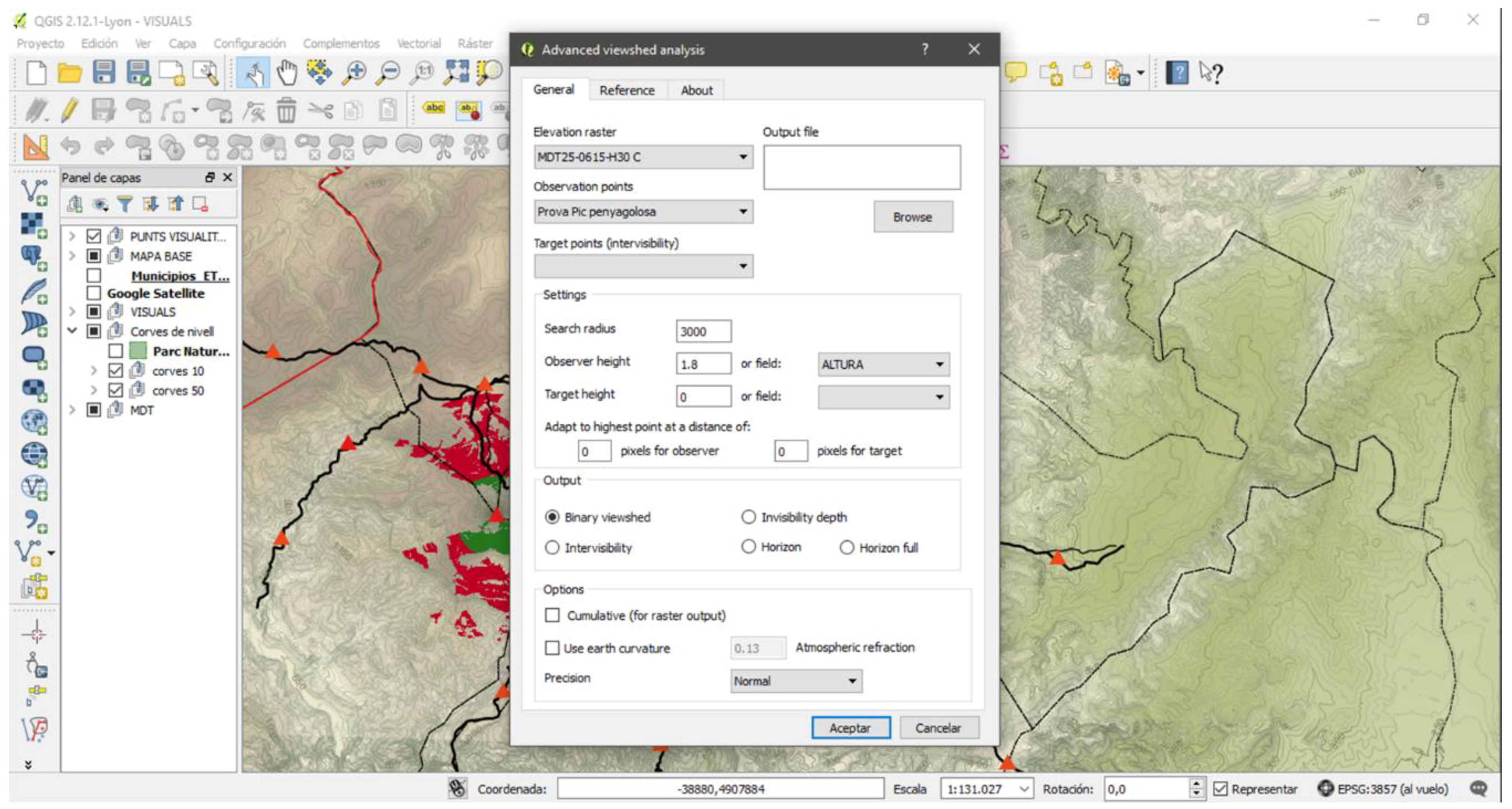
QGIS Lyon 2.12 software and the Viewshed Analysis plugin were used in this assessment. The tool gives several options for adding the data, and the following parameters were used in the process:
- Elevation raster: MDT25-0615-H30 C
- Observation points: selected by the user
- Output file: Mas Coria 1000 Alt0_2_Binary (for example)
- Search radius: 3000 or 1000 m (depending on the desired proximity)
- Observer height: standardized to 1.8 m
- Output: Binary Viewshed
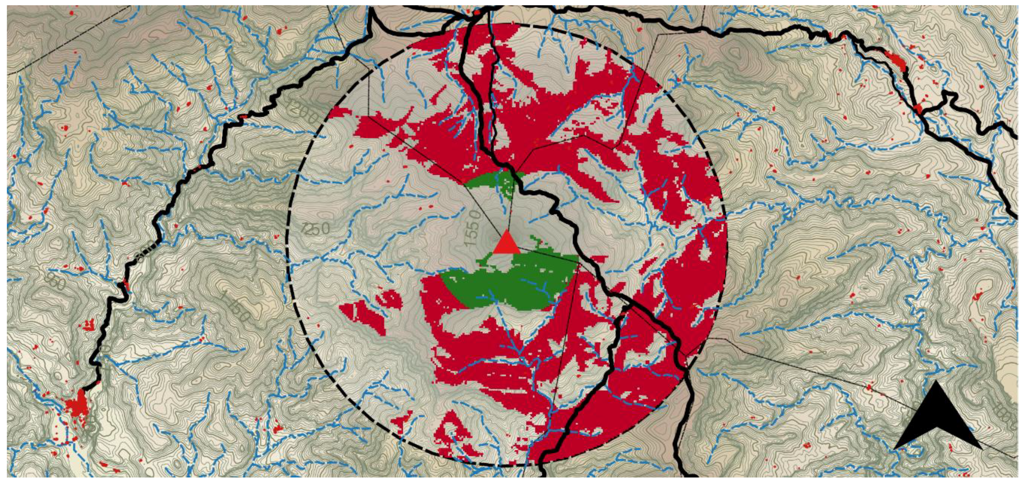
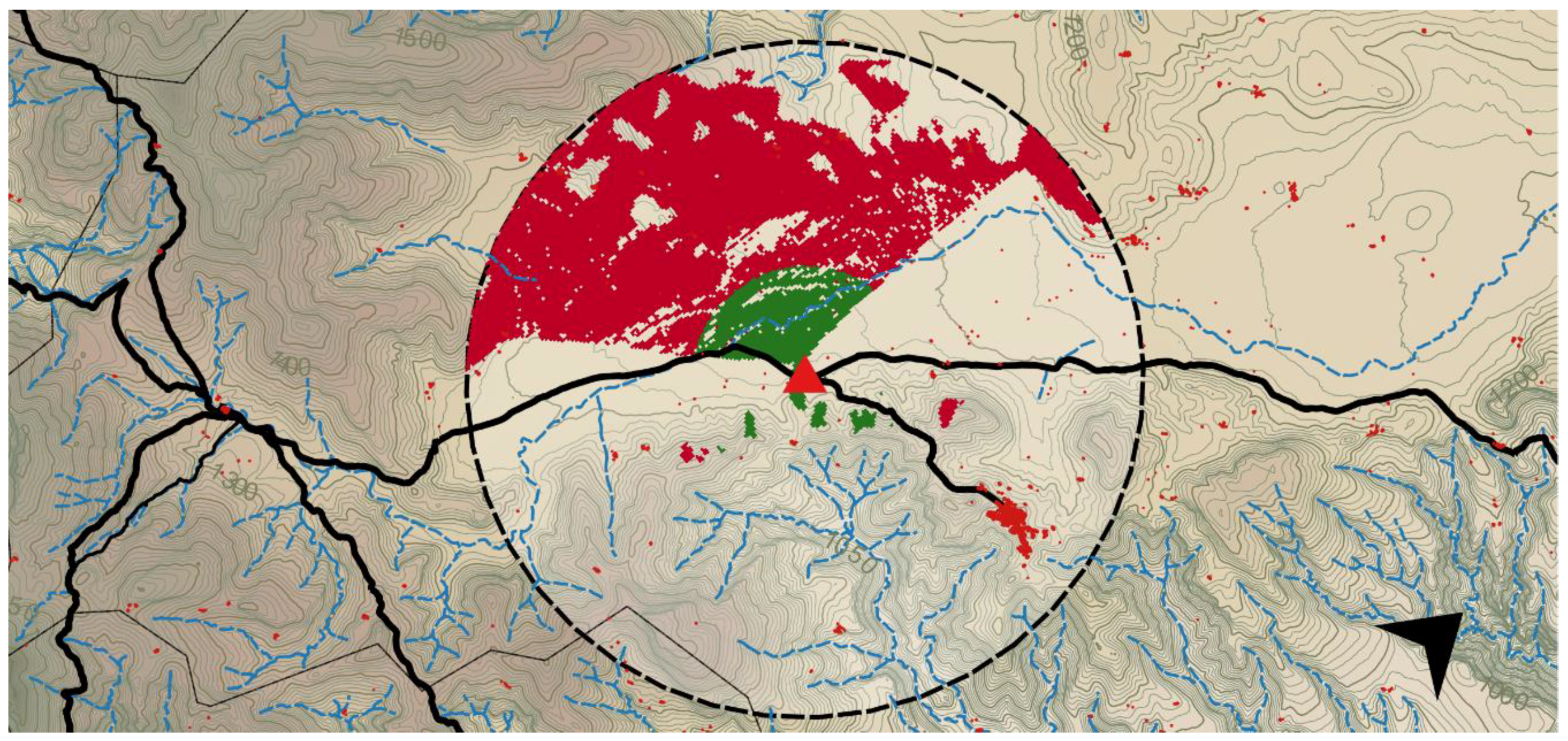
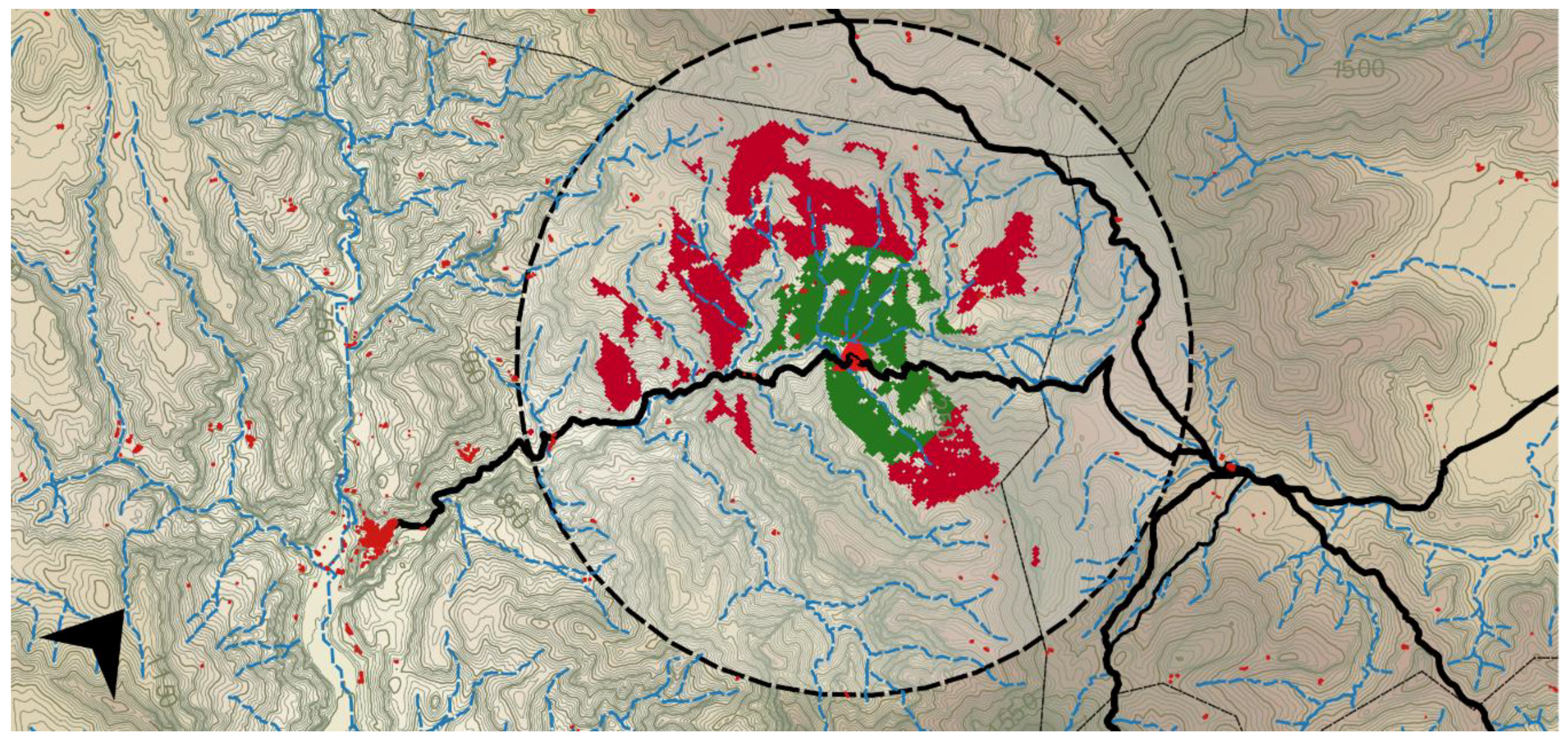
This process provides a raster layer based on altitude models that synthesizes information in cells termed Visible and Non-Visible. The final step is the assignment of transparency options through the layer style to the squares that are Non-Visible squares and a color to those that are Visible (Figure 5). The color green is used for short visual basins (1000 m), while the color red is used for long visual basins (up to 3000 m). In addition, differences were observed between three scenarios: peaks, plains, and ravines (Figure 6, Figures 8 and 10). Visual consecutive basins along the different routes were used in an initial trial. Nonetheless, it was concluded that these were not of use for the purposes of appreciating the different potential approaches of the landscape studied.
The raster layers with geographic information were downloaded from the Valencian Cartographic Institute website [60]. Observation points were established according to data retrieved from field work and methodological workshops in which the information gathered was analyzed with the collaboration of local residents.
The categorization systems and the monitoring of changes were determined by management tools (see Section 3.2). Landscape assessment work was produced in methodological workshops, using ad hoc surveys, where participants assigned value to the characteristics that make a place unique, or in contrast its values are common to others.
The research thus established five different criteria for the analysis of important areas of these mountainous landscapes (see Table 1):
- Landscape overview: completion of global disaggregated analysis;
- Intensity: analysis of the dominance of elements and the aesthetics they convey;
- Space: aesthetic composition;
- Visibility: selective interpretation of visual variables; and
- Fragility: alterations or impacts induced in the landscape or areas of “respect”.
Evaluation of Elevated Areas: The Case of Penyagolosa Mountain
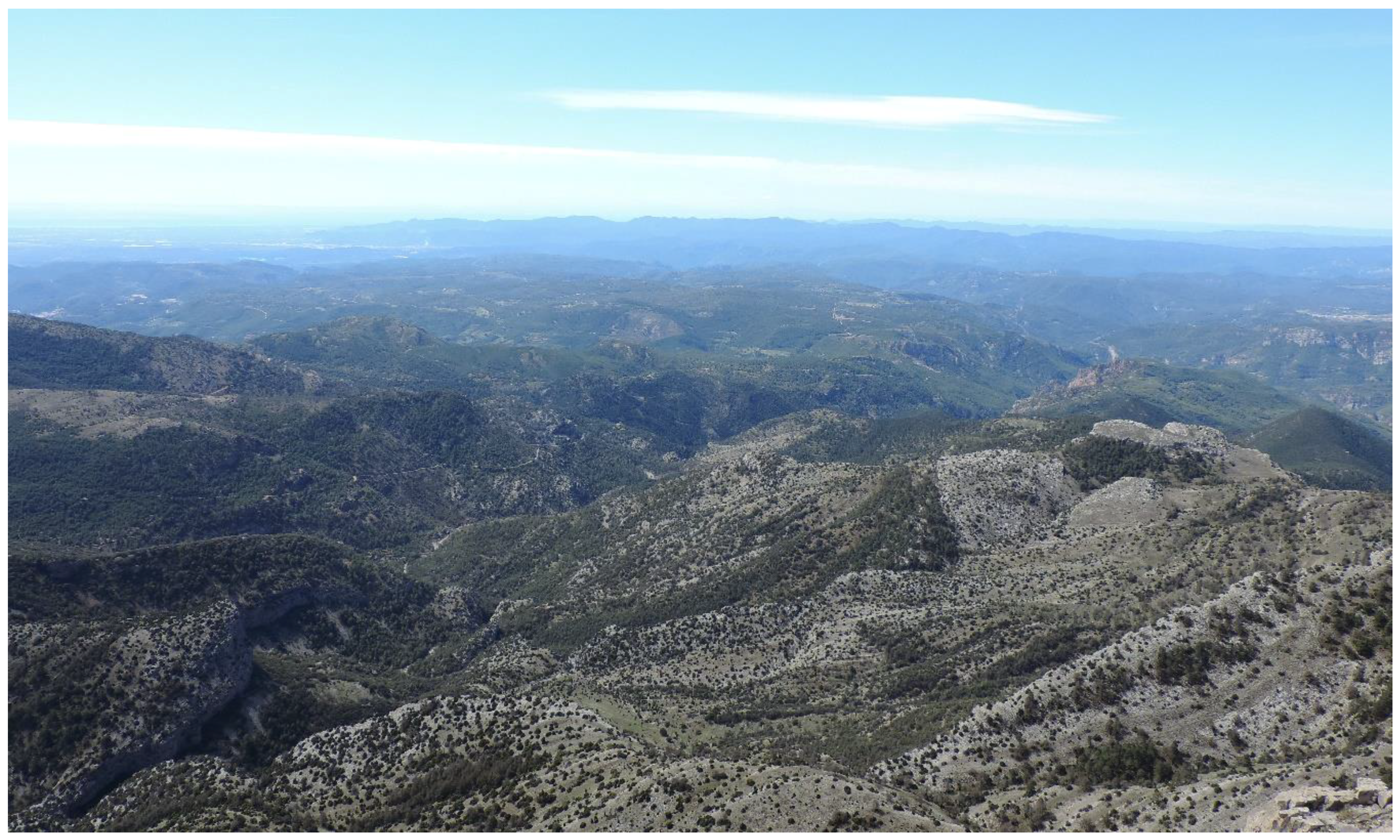
Steep areas offer dimensions with broad visibility. These places provide 360° panoramic views from which tourists can get an overview of the entire landscape. Using GIS software, Figure 6 offers a graphic representation where binaries in green and red are used to make the distinction between the view ranges at certain distances.
The views that can be gained from individual map positions are referenced as follows. When views allow distances equal or greater than 3000 m, they are shaded in red, and when the distance is about 1000 m, it is represented in green. Thus, locations could be selected according to panoramic views and the eventual importance of the different areas based on the assets and values expressed by inhabitants and visitors. Although aesthetic composition was more difficult to define here than in other locations, these areas provided some degree of uniformity (Figure 7). Paradoxically, this uniformity was often a contributing factor that added an abstract dimension to the landscape’s true character, in turn hindering the selective interpretation of visual variables by depriving the only goods visible from the attributes of authenticity and integrity.
From this elevated area, nature is the predominant value (Figure 6). The different morphological patterns in the area can be made out, as can the environmental variety, which depends on orientation, climate, flora, and fauna. Values such as ethnography, production, history, and culture were seen as mere elements configuring the vast landscape, albeit less so than other units of landscape. The ethnographic buildings found include structures made of ice or dry stone. Peaks bring a global vision to the aesthetic value of the place, which was also linked to the anthropological value. Culturally, these elevated areas have been and continue to be a benchmark for writers, painters, and other intellectuals and scholars from multiple disciplines, providing visitors with a particular evocative symbolism.
Evaluation of Flat Areas: The Plateau of Vistabella
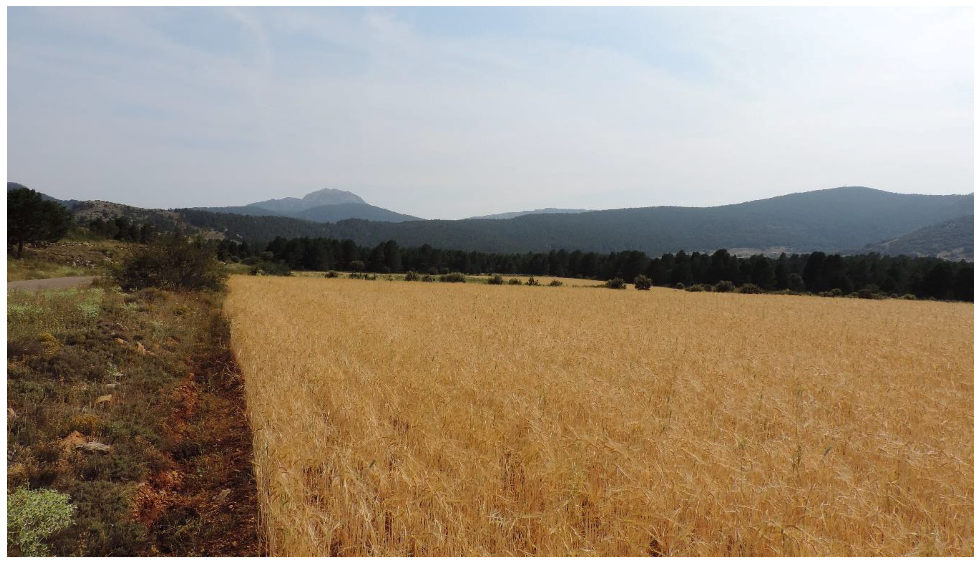
The area under study has few flat areas. In terms of perception, harmony is understood to be the combination of uniformity and entropy. Some scenic compositions prompt interest and are enhanced by the presence of discordant elements that proportionately break up the homogeneity. Of the perceptions described above for these cases, place provided observers with a global or broken-up vision of the landscape, which ultimately depended on what observers were able to notice. Here, the landscape was dominated by the rain-fed crops which brought continuity to the setting. Vernacular buildings seemed to be discordant elements that were scattered enough to aid understanding of the spatial relationship between dwellings and agricultural activity. In certain locations, harmony could be fragile. Observers could recognize other contemporary adaptations in traditional constructions reconfiguring the aesthetics of the place as well as judgements of authenticity and integrity. Figure 9 shows how observers are conditioned by the mountain in the background and the crops in the foreground. An aerial observation, Figure 8, provides a 180° panoramic view of the flat area. GIS analysis presents a fragmented vision of the landscape in green, while global vision of the surroundings is offered in red.
The plateau of Vistabella, at an altitude of 1100 m, was the only flat area of significance in the region. There is still a predominance of values associated to agricultural production (Figure 9), as fields are still used for crops, albeit with contemporary agricultural techniques. Place was of great aesthetic importance, with the crops treating visitors to a charming selection of hues that change with the seasons of the year. Other values such as the cultural, ethnographic, and historical ones—taking the form of farmhouses, wells, fountains, shepherd huts, and other dry-stone structures—could also be observed in the surroundings. In addition, intangible values associated to tradition and other contemporary practices were found in some areas near the plateau and visitors must kept their distance and respected them. In a way, this fragility was as important as the particular natural values of the place, resulting from this unique setting. The plateau of Vistabella is a polje, a karst plain with a seasonal river which can flood the area in severe climatic conditions.
Evaluation of Ravine Areas: The Case of the Carbo River
This part of the study focused on ravine areas. According to the criteria featured above, these areas were conditioned by a closer vision, and therefore, a more precise disaggregated analysis could be carried out. These areas usually had a natural dominance, with trees and bushes prevailing on the slopes, while stationary powerful water flows and natural pools dominated the basin area of these valleys.
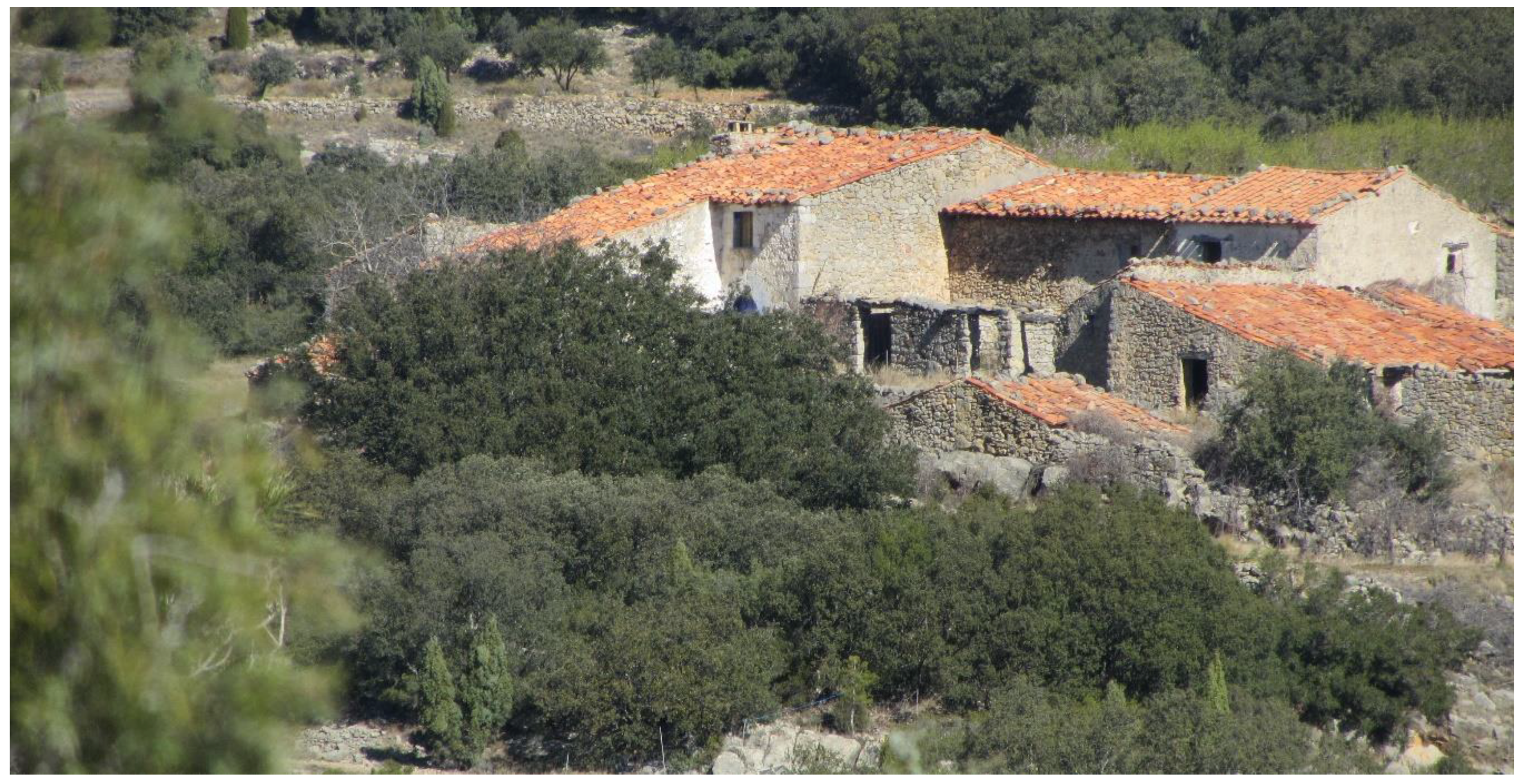
In ethnographical terms, small hamlets and scattered farmhouses made up a semi-structured landscape, which was not very evident or complex, but was varied and entertaining. Environmental processes resulted in a systemic organization with compositions in varying degrees of order. Spreading vegetation and abandonment could be observed depending on the height and orientation of the slopes, as well as the focal distances. The area could be perceived as “affected” by abandonment and by minor alterations induced by human activity. Nonetheless, impacts could be identified, managed, and potentially reversed, either completely or partly. Similarly, accurate details could be overseen in situ, by applying the criteria of distances for tourist consumption, and depending on position. In this, the authenticity and integrity of the scenery must be taken into consideration and perceived in keeping with past and present realities. Figure 10 highlights the slopes of the ravine in red. Accordingly, this vision was much more constrained than that of previous cases. This approach also provided observers with subtlety so they could focus on specific heritage assets. The areas featured in green reflected closer heterogeneous details and a prevalence of the most communicative visualization of specific cultural values (Figure 11).
3. Discussion: What Is Authentic, Original, and Local?
These landscapes bear considerable witness to human adaptation in regions with a scarcity of living resources: extreme orographic conditions, terraced slopes, extensive grazing land, fields for cultivation, vineyards, and fruit crops. Horticulture and agro-pastoral activities came to fully exploit the existing resources. These landscapes bear witness to the continuous evolution of human settlements and provide an exceptional response. The direct effects of wars and dictatorship on these continuously populated lands marked the start of a process of abandonment and depopulation, which worsened later when owners moved from the hinterland to the better-paid coastal activities resulting from economic development in the final decades of the 20th century.
The terms “visualization” and “authenticity” in landscapes, as referenced by UNESCO, do not just denote how a landscape evolves and is affected in material terms. They also relate to how the past is viewed and experienced by locals and foreigners alike, a key aspect in many heritage studies [61], and to whether it offers a sense of identity, anchoring collective memory by providing tangible links between past, present, and future [62]. In this regard, given that views and perceptions of landscape are not merely deeply rooted in society, the evolution of a landscape is a characteristic factor with a culturally dependent outcome.
Previous research identified two major trends in terms of the perceptions of abandoned landscapes that appeared in Europe. The first of these trends reflects rejection, while the second highlights the poetic connotations and feelings of freedom associated with these spaces [63,64]. The social impact brought about by the enclosure of landscape by forests and the loss of scenic qualities, together with depopulation and the loss of perception of a well-managed landscape, can give rise to feelings of desolation, isolation, oppression, and loss of contact [65,66]. In keeping with this, some believe that the landscape is defaced by the enclosure of mountain landscapes, the disappearance of contours, and the loss of spatial hierarchies [67].
Landscapes have an important tale to tell, highly influenced by the successive layers of socio-economic and cultural evolution of each place. The perception, valuation, and re-enactment of abandoned cultural landscapes rely on knowledge. Given that landscape is something to be constructed, both physically and intellectually, the recognition of more than one epistemology should not be ruled out. Knowing and helping others to identify how a present layer is a response to previous layers and the framework for later changes will directly affect the way a landscape is managed. In fact, one of the many ways to understand the history of landscape change is recognizing that change itself is actually a part of the landscape [68], even if change means abandonment.
As a result of this, previous debates of authenticity in specific landscapes, such as abandoned ones, can be questioned. In this regard, recent theories consider dynamic authenticity to be based on present perception, action, experience, and social practice, as well as values of time and place [23]. This is about objects making or transforming space, and no longer merely being part of it [69]. The dynamically authentic object is directly affected by contemporary decision-making processes and is the result of cumulative socio-cultural reconstructions by modest cultures. Its value therefore lies in how objects reflect the circumstances rather than its own importance.
Static authenticity is found in every heritage object that somehow retains or attaches importance to embedded values from the past today, irrespective of cultural background, flows, or transmigrations. Given that static authenticity is fundamentally based on the materiality of the object, it needs to be implemented forcefully using dynamic authenticity so that the heritage object can provide a sincere response to context, time, and place [14].
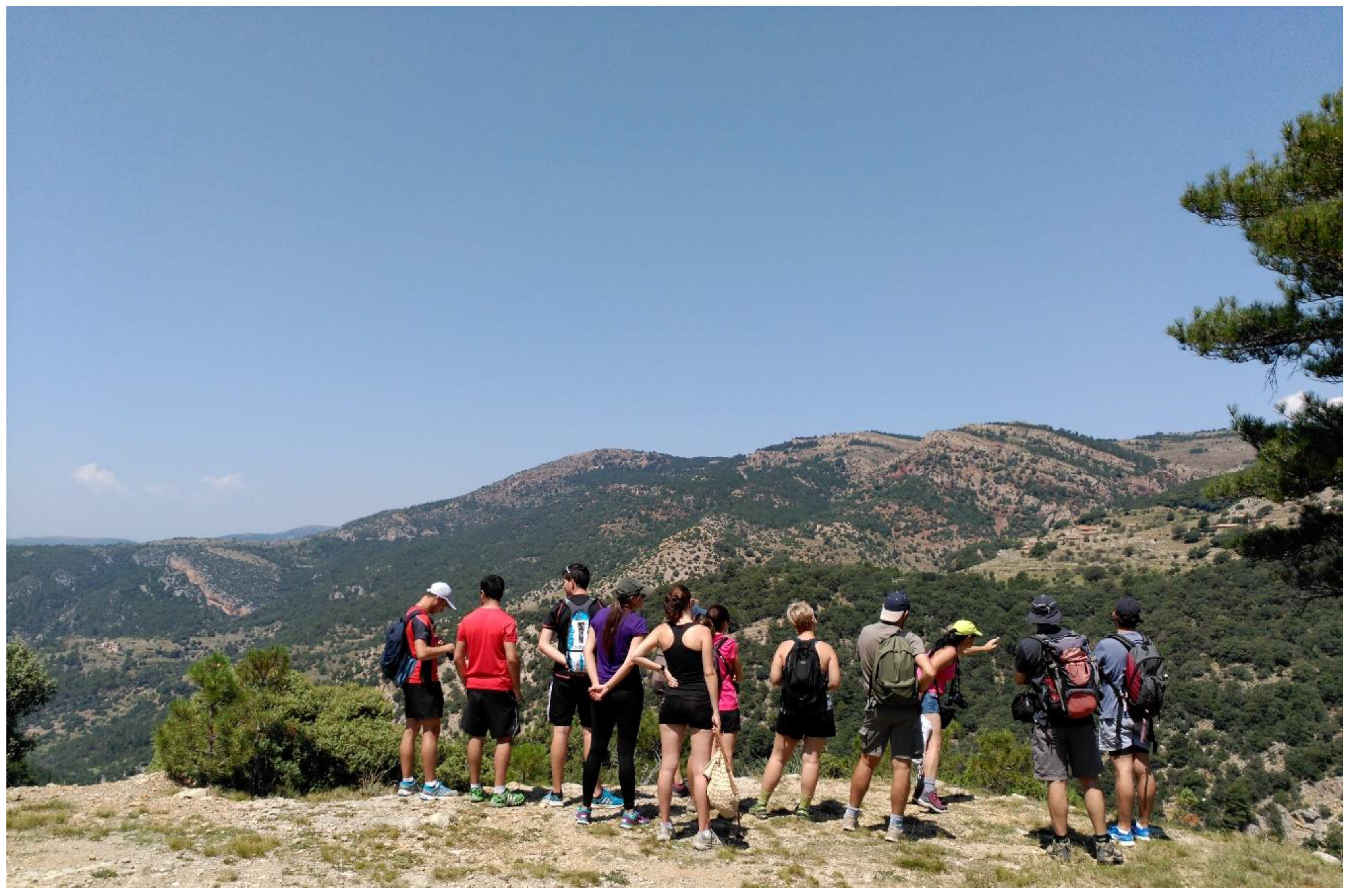
The perception at short distances provides subtlety. As a result of this subtlety and the different points of observation examined in this study, concepts such as authenticity and integrity play a key role in the management of spaces. The task of preserving the character of the abandoned landscapes requires extensive thought to be given once more to these concepts, as well as to how the intangible can be made a permanent and visible factor in landscapes. Although vernacular constructions and representations have continued to endow landscapes with a powerful character, they no longer fulfil their original function (Figure 12).
Abandonment brings mysticism, an intangible manifestation that remains materially in the landscape. In terms of cultural significance, other intangible values and the landscape they are found in are key elements in the recognition of identity, and in turn help to identify specific fragile areas. These fragile areas are determined not only by specific hallmarks, but also by modest and ordinary spaces [70].
Previous results on the assessment of the landscape may be culturally conditioned, as identity depends on collectives, not on cultures. Although cultural significance and identity can coexist within a collective, collective identity is born from a collective process of conscious “seduction” or creation. Identity is therefore a process developed from the bottom up [71] and entails discovery, interpretation, and of course, understanding [72]. One hypothesis is that the rural changes currently occurring in this type of landscapes create microidentities [73] based on localisms.
After the assessment, the authors noted how most people felt they were represented by the heritage elements of their municipality, except in the case of Mount Penyagolosa and its sanctuary. The mountain was seen as a symbolic identitarian element in all the municipalities together with life in the masías, with their architecture, tradition, nature, etc., resulting in a shared landscape that facilitated a joint cultural image. It can thus be asserted that the limits of culture did not match those of identity, although they help to prioritize frameworks for conservation.
A survey on stakeholders’ perception was conducted among 400 participants from the 10 villages surrounding Penyagolosa. The aim of this survey was to ascertain the criteria locals applied when perceiving authenticity in this landscape. Responses were divided into three groups: (a) the landscape contains and conserves the original anthropic use, (b) the landscape contains the use, but due to abandonment some anthropic components are not visible, and (c) the landscape has completely lost all signs of past uses. Option (a) accounted for 40% of responses and is therefore considered a positive and significant exercise in collective memory. Option (b), which accounted for 50% of the total of the survey, shows the extent to which people perceive the state of emergency of certain local ecosystems. Finally, the least popular option (c) with a total of 10%, highlights how abandonment is considered negative, while the landscape containing it is perceived as positive.
3.1. Classification and Consideration of These Types of Landscapes by UNESCO
On an international scale, several landscapes fitting this description of Mediterranean physiognomy have already been listed under Criterion 5 as world heritage properties under threat from modern economic development, rural depopulation, and the abandonment of traditional agricultural practices. These include The Holy Valley and the forest of Cedars of God (Lebanon) and Portovenere, Cinque Terre (Italy), listed in 1998 and 1992 respectively for “the harmonious interaction between people and nature to produce a landscape of exceptional scenic quality that illustrates a traditional way of life”. In the twenty-five years since this declaration, it has become clear that these were included for their visual integrity and material-original authenticity. Despite the absence of specific information, it can be assumed that the abandonment, transformation, and decay of the traditional way of life in the hinterlands were ignored.
The integrity of another two recent inclusions (2011), the Cultural Landscape of Sierra de Tramuntana (Spain) and Causses and Cévennes, Mediterranean agro-pastoral Cultural Landscape (France) have been analyzed differently. Although the project for the former was accepted for its visual integrity, which it had “retained to a considerable extent”, it was also pointed out that the fragility of the structural integrity was “due to the progressive increase of tourism”. In the case of Causses and Cévennes, the project made no mention of visual or structural integrity. This wholeness and intactness were associated with the intangibility of agro-pastoralism, said to be almost obsolete in the landscape of the time.
In terms of authenticity, the case of the Tramuntana highlights the decline in traditional dynamic processes. However, this landscape has been preserved thanks to the awareness of the many wealthy artists and intellectuals living in this evocative setting. In the case of Causses and Cévennes, this relict landscape is said to have maintained a certain degree of authenticity that is in need of conservation. Nevertheless, in both cases, once the social construction of the landscape is disrupted, rural landscapes replace their simplicity with other rather different new material processes.
Due to the control referenced above, no mention was made of the values of contemporary adaptations of materiality. When working on these candidacies UNESCO treats landscape as something outstanding, which has evolved over centuries and kept safe from contemporary pervasive threats, rather than attempting to understand certain forms of contemporary eclecticism, abandonment, decay, or even destruction deriving from uncontrolled actions. Of course, not all forms of eclecticism, abandonment, or reconstruction could be considered valid. However, when referring to the rural landscapes of necessity and faith, any form of social reconstruction will probably lead to honest and respectful conservation of its material form.
In a later declaration (2014), the Vineyard Landscape of Piedmont: Langhe-Roero and Monferrato, UNESCO declared that the property possessed the qualities of cultural, residential, architectural, environmental, and productive integrity. These defining qualities suggest that integrity is acquiring the range of definition that has been sought throughout the last decade. Nevertheless, the criteria for ascertaining the validity of cultural and architectural continuity are not specified.
None of the World Heritage Cultural Landscapes mentioned earlier refer to the authenticity and integrity of the sincere response to rural life, inherited vernacular architecture, or the contemporary architecture of “humble” pseudo-indigenous people, excessively patronized by our understanding or neglect. This intellectual appropriation is therefore leading to an architecture devoid of the spontaneous expression of humility, necessity, and faith. Thus, folklore and other types of intangible performance can clearly be pure yet spontaneous and contemporary. Why is this not true of architectural objects to the same extent? This architecture is only produced when the contemporary socio-economic and cultural integrity of the landscape and its structure co-exist with abandonment, decay or “latent” maintenance, enabling a “dynamic integrity and authenticity” to be found together with the continuity of the materiality of the property in itself [14].
3.2. Framework for the Conservation and Sustainability of Vernacular Landscapes
A sustainable tourist approach may depend on whether the observer is looking for the cultural process of landscape, which is dynamic, or for the visual experience that occurs in a spatially static landscape. Close observations or more removed ones, such as those detailed here, are based on perceptual experiences and respect. Observers looking for global experiences and visions of landscape should look to locations with wide-ranging perspectives, such as those provided by elevations and plateaus. In contrast, those looking at a more heterogeneous or vibrant cultural dynamism, or even at its complexities, may require closer examination. The design of locations in abandoned cultural landscapes aims to strengthen experiences, intensity, aesthetics, visualization, and respect without polarizing or excessively defacing the character of the place. Therefore, one form of sustainable approach requires places to be understood while planning based on distance—areas of lower or higher intensity pressures—adding to the understanding and respect of the extrinsic and intrinsic processes this type of fragile areas inhabited by pseudo-indigenous people are subject to. There is thus a need to correctly convey the values of authenticity and integrity of landscapes, and how they are dependent on dynamic and static interactions, which in turn define context, time, and place. It can be stated that sustainable approaches to abandoned cultural landscapes are in need of perceptions, assessments, and cultural immersions that are supported by knowledge and interpretation.
Areas of special care (ASC) in vernacular landscapes are subject to conservation objectives and operational objectives for the eventual application of a tourism competitiveness plan. At the same time, operational objectives can be achieved by a series of strategic measures, regulatory norms, and executive measures, conservation objectives address intervention priorities and levels of protection. The contextual or global nature of these objectives will greatly affect the character and assessment of the landscape.
The objectives of conservation for sustainable tourism planning tools need to meet priorities for intervention, respecting different levels of protection. These two parameters guarantee the continuity of the character and diversity of natural, social, and cultural values of specific periods, cognition, and approach in contemporary habitats, which to some extent are open to dynamism but are somehow susceptible to suffer from imposed unbalanced affections.
The priorities for intervention on habitats of abandoned vernacular landscapes are based on three levels of intensity: (1) high intensity habitats with great biodiversity in a remarkable environment from the point of view of the natural, social and cultural landscape, (2) average intensity, which are habitats with great biodiversity in an environment that is not remarkable in terms of the point of view of the natural, social, and cultural landscape (in these two cases, a prevailing pattern of conservation could be maintained in the study area), and (3) low intensity, i.e., other habitats.
The levels of protection of these habitats are therefore established based on the state of conservation and the perception of this conservation. This classification also relies on three levels—A, B, and C. When the global value of a specific place is A (excellent), the protection goal will be to maintain that value if agreed. When the global value is B (good) or C (significant), the protection goal will be to increase it to the next highest value if possible (A or B, respectively). Therefore, the combination of both scales can result in a notable parametric approach for different zones in vernacular landscapes.
The success of a correct management rests in the follow-up and in the continuous collection of information. Objectively verifiable indicators and their subsequent evaluation can be used to verify the degree of implementation of these measures, their effects on the operational objectives, and possible variations in the level of protection of the habitats.
4. Conclusions
This research has identified some challenges and opportunities affecting abandoned vernacular landscapes. Sustainable approaches rely on methodologies that are subjective and to some extent linked to the idiosyncrasy of individual places. Assessment of the landscape based on geomorphological standards was valid given the simplicity of the abstraction of assets and values, as entire areas share common features thus facilitating an understanding of preservation criteria. The analysis of three landscape categories greatly facilitated assessment by allowing easy comparison of areas. GIS and rigorous fieldwork provided these details, helping the categorization of the elements perceived that are to be observed and their changes over time. This shows the usefulness of GIS tools in categorizing spaces. Categorization is understood to be applicable to different heritage environments when categories are open not only to changes, but also to perception. It seems undeniable that personal factors affect the perception of the landscape, and these factors are always linked to subjectivity. Nonetheless, individuals who are taught to interpret also understand certain complex attributes of the landscape and can draw a network of values that can characterize a place.
However, as long as abandonment is accepted as a variable induced by time, it must be managed according to the dynamic character of the authenticity and integrity of the place. In order to ensure success, this research has highlighted how improvements can be implemented when applying the concept of intensity area to previous zoning systems. The plurality of zones and the different options when evaluating values and when choosing locations all work towards updating tourism planning tools. This is especially applicable when the goal is to maintain diversity of social and cultural interaction within multi-faceted living sites.
To this end, intensity areas must be functional and critical in understanding contexts to subsequently ensure principles of integration and consistency for the landscape. These are “nursing zones” or zones for special care and knowledge. Tourism in abandoned vernacular landscapes can be complex because these are heterogeneous and fragile. They require careful study, ethics, and comprehension in order to ascertain their character. They call for a type of tourism that is sensitive and able to recognize the environment, appropriating its cultural values, both past and present. Areas of intensity, itineraries, and other non-invasive resources and policies open up new paths of inquiry for future research on the critical analysis of heritage places, as well as methodologies challenging mass tourism both in rural locations and urban environments. Ultimately, these challenges help ensure that the sustainability and diversity of social and cultural living sites are treated sensitively.
Author Contributions
Conceptualization, J.A.G.-E.; Methodology, J.A.G.-E. and P.A.; Software, P.A.; Validation and Formal Analysis, J.A.G.-E. and P.A.; Investigation, J.A.G.-E. and P.A.; Resources, J.A.G.-E. and P.A.; Data Curation, J.A.G.-E.; Writing-Original Draft Preparation, P.A. and J.A.G.-E.; Writing-Review & Editing, J.A.G.-E.; Funding Acquisition, J.A.G.-E.
Funding
This research was funded by the Ministry of Economy and Competitiveness in Spain, MINECO. CSO2015.65787-C6-6-P, and Generalitat Valenciana grant number [GV/2017/100]. The fieldwork was funded by Diputación de Castellón through the Chair on Historic Villages and Cultural Routes in Castellón.
Acknowledgments
I would like to thank the three reviewers of this paper for the invaluable comments provided, as they have helped to greatly enhance the discussion included within the manuscript.
Conflicts of Interest
The authors declare no conflict of interest and the funders had no role in the design of the study; in the collection, analyses, or interpretation of data; in the writing of the manuscript; or in the decision to publish the results.
References
- Higgins-Desbiolles, F. Sustainable tourism: Sustaining tourism or something more? Tour. Manag. Perspect. 2018, 25, 157–160. [Google Scholar] [CrossRef]
- Butler, R.W. Tourism: An evolutionary perspective. In Tourism and Sustainable Development: A Civic Approach; Nelson, J.G., Butler, R., Wall, G., Eds.; University of Waterloo: Waterloo, ON, Canada, 1999; pp. 33–63. [Google Scholar]
- Ruhanen, L. Local government: Facilitator or inhibitor of sustainable tourism development? J. Sustain. Tour. 2013, 21, 80–98. [Google Scholar] [CrossRef]
- Wesley, A.; Pforr, C. The governance of coastal tourism: Unravelling the layers of complexity at Smiths Beach, Western Australia. J. Sustain. Tour. 2010, 18, 773–792. [Google Scholar] [CrossRef]
- Hall, C.M. Tourism Planning: Policies, Processes and Relationships; Pearson Education: Upper Saddle River, NJ, USA, 2008. [Google Scholar]
- Snowdon, P.; Slee, B.; Farr, H. The economic impacts of different types of tourism in upland and mountain areas of Europe. In Tourism and Development in Mountain Regions; Godde, P.M., Price, M.F., Zimmerman, F.M., Eds.; CABI Publisher: Wallingford, UK, 2000; pp. 137–157. [Google Scholar]
- Stebbins, R.A. Cultural tourism as serious leisure. Ann. Tour. Res. 1996, 23, 948–950. [Google Scholar] [CrossRef]
- Jovicic, D. Cultural tourism in the context of relations between mass and alternative tourism. Curr. Issues Tour. 2014, 19, 605–612. [Google Scholar] [CrossRef]
- Tiberghien, G.; Bremner, H.; Milne, S. Performance and visitors’ perception of authenticity in eco-cultural tourism. Tourism Geographies. Int. J. Tour. Space Place Environ. 2017, 19, 287–300. [Google Scholar]
- Matsuoka, R.H.; Kaplan, R. People needs in the urban landscape: Analysis of Landscape and Urban Planning contributions. Landsc. Urban Plan. 2008, 84, 7–19. [Google Scholar] [CrossRef]
- Gobster, P.H.; Nassauer, J.; Daniel, T.C.; Fry, G. The shared landscape: What does aesthetics have to do with ecology? Landsc. Ecol. 2007, 22, 959–972. [Google Scholar] [CrossRef]
- Fredheim, L.H.; Khalaf, M. The significance of values: Heritage value typologies re-examined. Int. J. Herit. Stud. 2016, 22, 466–481. [Google Scholar] [CrossRef]
- Parkinson, A.; Scott, M.; Redmond, D. Competing discourses of built heritage: Lay values in Irish conservation planning. Int. J. Herit. Stud. 2016, 22, 261–273. [Google Scholar] [CrossRef]
- García-Esparza, J.A. Are World Heritage concepts of integrity and authenticity lacking in dynamism? A critical approach to Mediterranean autotopic landscapes. Landsc. Res. 2017. [Google Scholar] [CrossRef]
- García-Esparza, J.A. Re-thinking the validity of the past. Deconstructing what authenticity and integrity mean to the fruition of cultural heritage. Vitruvio—Int. J. Arch. Technol. Sustain. 2016, 1, 20–33. [Google Scholar] [CrossRef]
- ICOMOS. ICOMOS-IFLA Principles Concerning Rural Landscapes as Heritage. In Proceedings of the 19th ICOMOS General Assembly and Scientific Symposium, New Delhi, India, 11–15 December 2017. [Google Scholar]
- Silva, R.; Fernández, V. El nuevo paradigma del patrimonio y su consideración con los paisajes: Conceptos, métodos y prospectivas. Doc. Anàl. Geogr. 2017, 63, 129–151. [Google Scholar] [CrossRef]
- Cohen, E. Authenticity and commoditization in tourism. Ann. Tour. Res. 1988, 15, 371–386. [Google Scholar] [CrossRef]
- Hall, C.M. Response to Yeoman et al: The fakery of ‘The authentic tourist’. Tour. Manag. 2007, 28, 1139–1140. [Google Scholar] [CrossRef]
- Smith, L. El “espejo patrimonial”. ¿ilusión narcisista o reflexion es múltiples? Antipoda 2011, 12, 39–63. [Google Scholar] [CrossRef]
- De la Torre, M. Values and Heritage Conservation. Herit. Soc. 2013, 6, 155–166. [Google Scholar] [CrossRef]
- Spennermann, D.H.R. Gauging Community Values in Historic Preservation. CRM J. Herit. Steward. 2006, 3, 6–20. [Google Scholar]
- Pendlebury, J.; Gibson, L. Valuing historic environments. In Valuing Historic Environments; Pendlebury, J., Gibson, L., Eds.; Ashgate: Farnham, UK, 2009; pp. 1–18. [Google Scholar]
- Nassauer, J. Care and stewardship: From home to planet. Landsc. Urban Plan. 2011, 100, 321–323. [Google Scholar] [CrossRef]
- Domon, G. Landscape as resource: Consequences, challenges and opportunities for rural development. Landsc. Urban Plan. 2011, 100, 338–340. [Google Scholar] [CrossRef]
- Nassauer, J.; Opdam, P. Design in science: Extending the landscape ecology paradigm. Landsc. Ecol. 2008, 23, 633–644. [Google Scholar] [CrossRef]
- Stenseke, M. Integrated landscape management and the complicating issue of temporality. Landsc. Res. 2016, 41, 199–211. [Google Scholar] [CrossRef]
- Harvey, D.C. Heritage Pasts and Heritage Presents: Temporality, meaning and the scope of heritage studies. Int. J. Herit. Stud. 2010, 7, 319–338. [Google Scholar] [CrossRef]
- Coeterier, J.F. Dominant attributes in the perception and evaluation of the Dutch landscape. Landsc. Urban Plan. 1996, 34, 27–44. [Google Scholar] [CrossRef]
- Roncero i Ventura, E. Al Voltant de Penyagolosa; Tàndem Edicions: València, Spain, 2006. [Google Scholar]
- MacDonald, D.; Crabtree, J.; Wiesinger, G.; Dax, T.; Stamou, N.; Fleury, P.; Gutierrez Lazpita, J.; Gibon, A. Agricultural abandonment in mountain areas of Europe: Environmental consequences and policy response. J. Environ. Manag. 2000, 59, 47–69. [Google Scholar] [CrossRef] [Green Version]
- Benayas, J.; Martins, A.; Nicolau, J.; Schulz, J. Abandonment of agricultural land: An overview of drivers and consequences. CAB Rev. 2007, 2, 1–14. [Google Scholar] [CrossRef]
- Agnoletti, M. Rural landscape, nature conservation and culture: Some notes on research trends and management approaches from a (southern) European perspective. Landsc. Urban Plan. 2014, 126, 66–73. [Google Scholar] [CrossRef]
- Martin, O.; Patti, G. World Heritage and Buffer Zones; World Heritage Papers 25; Unesco World Heritage Centre: Paris, France, 2009; pp. 21–79. [Google Scholar]
- Europe, Co. Landscape and Sustainable Development of the European Landscape Convention; Council of Europe: Strasbourg, France, 2006. [Google Scholar]
- Hourdequin, M.; Havlick, D.G. Restoring Layered Landscapes: History, Ecology, and Culture; Oxford University Press: Oxford, UK, 2016. [Google Scholar]
- Navarro, L.M.; Pereira, H.M. Rewilding Abandoned Landscapes in Europe. Ecosystems 2012, 15, 900–912. [Google Scholar] [CrossRef] [Green Version]
- Pendlebury, J.; Townshend, T. The Conservation of Historic Areas and Public Participation. J. Arch. Conserv. 2014, 5, 72–87. [Google Scholar] [CrossRef]
- Dalglish, C.; Leslie, A. A question of what matters: Landscape characterisation as a process of situated, problem-orientated. Landsc. Res. 2016, 41, 212–226. [Google Scholar] [CrossRef]
- Sánchez-Carretero, C.; Jiménez-Esquinas, G. Relaciones Entre Actores Patrimoniales: Gobernanza Patrimonial, Modelos Neoliberales y Procesos Participativos. Revista Ph. 2016. Available online: http://www.iaph.es/revistaph/index.php/revistaph/article/view/3827 (accessed on 8 January 2018).
- English Heritage. Conservation Principles: Policies and Guidance for the Sustainable Management of the Historic Environment; English Heritage: London, UK, 2008. [Google Scholar]
- Stephenson, J. The Cultural Values Model: An Integrated Approach to Values in Landscapes. Landsc. Urban Plan. 2008, 84, 127–139. [Google Scholar] [CrossRef]
- Pocock, C.; Collett, D.; Baulch, L. Assessing stories before sites: Identifying the tangible from the intangible. Int. J. Herit. Stud. 2015, 21, 962–982. [Google Scholar] [CrossRef]
- Pendlebury, J. Conservation values, the authorised heritage discourse and the conservation-planning assemblage. Int. J. Herit. Stud. 2013, 19, 709–727. [Google Scholar] [CrossRef]
- Speed, J.; Austrheim, G.; Birks, H.; Johnson, S.; Kvamme, M.; Nagy, L.; Thompson, D. Natural and cultural heritage in mountain landscapes: Towards an integrated valuation. Int. J. Biodivers. Sci. Ecosyst. Serv. Manag. 2012, 8, 313–320. [Google Scholar] [CrossRef]
- Harrison, R. Beyond “Natural” and “Cultural” Heritage: Toward an Ontological Politics of Heritage in the Age of Anthropocene. Herit. Soc. 2015, 8, 24–42. [Google Scholar] [CrossRef] [Green Version]
- Stephenson, J. The dimensional landscape model: Exploring differences in expressing and locating landscape qualities. Landsc. Res. 2010, 35, 299–318. [Google Scholar] [CrossRef]
- Swanwick, C. Landscape Character Assessment: Guidance for England and Scotland, the Countryside Agency and Scottish Natural Heritage. 2002. Available online: http://publications.naturalengland.org.uk/publication/2671754 (accessed on 17 May 2017).
- Tudor, C. An Approach to Landscape Character Assessment, Natural England. 2014. Available online: https://www.gov.uk/government/publications/landscape-character-assessments-identify-and-describe-landscape-types (accessed on 17 May 2017).
- Wagtendonk, A.J.; Vermaat, J.E. Visual perception of cluttering in landscapes: Developing a low resolution GIS-evaluation method. Landsc. Urban Plan. 2014, 124, 85–92. [Google Scholar] [CrossRef]
- Saygi, G.; Remondino, F. Management of Architectural Heritage Information in BIM and GIS: State-of-the-art and Future Perspectives. Int. J. Herit. Digit. Era. 2013, 2, 695–713. [Google Scholar] [CrossRef]
- Brown, G.; Fagerholm, N. Empirical PPGIS/PGIS mapping of ecosystem services. A review and evaluation. Ecosyst. Serv. 2015, 13, 119–133. [Google Scholar] [CrossRef]
- Brown, G.; Weber, D.; de Bie, K. Assessing the value of public lands using public participation GIS (PPGIS) and social landscape metrics. Appl. Geogr. 2014, 77–89, 77–89. [Google Scholar] [CrossRef]
- Tempesta, T. The perception of agrarian historical landscapes: A study of the Veneto plain in Italy. Landsc. Urban Plan. 2010, 97, 258–272. [Google Scholar] [CrossRef]
- Stewar, T.P.; Liebert, D.; Larkin, K.W. Community identities as visions for landscape change. Landsc. Urban Plan. 2004, 69, 315–334. [Google Scholar] [CrossRef]
- Dupont, L.; Antrop, M.; Van Eetvelde, V. Does landscape related expertise influence the visual perception of landscape photographs? Implications for participatory landscape planning and management. Landsc. Urban Plan. 2015, 141, 68–77. [Google Scholar] [CrossRef]
- Martín, B.; Ortega, E.; Otero, I.; Arce, R.M. Landscape character assessment with GIS using map-based indicators and photographs in the relationship between landscape and roads. J. Environ. Manag. 2016, 180, 324–334. [Google Scholar] [CrossRef] [PubMed]
- Chamberlain, B.C.; Meitner, M.J. A route-based visibility analysis for landscape management. Landsc. Urban Plan. 2013, 111, 13–24. [Google Scholar] [CrossRef]
- Nutsford, D.; Reitsma, F.; Pearson, A.L.; Kingham, S. Personalising the viewshed: Visibility analysis from the human perspective. Appl. Geogr. 2015, 62, 1–7. [Google Scholar] [CrossRef] [Green Version]
- Institut Cartogràfic Valencià (GVA). Cartographic Database Icv.gva.es. 2018. Available online: http://www.icv.gva.es/es (accessed on 20 July 2017).
- Waitt, G. Consuming heritage: Perceived historical authenticity. Ann. Tour. Res. 2000, 27, 835–862. [Google Scholar] [CrossRef]
- Millar, S. Heritage management for heritage tourism. Tour. Manag. 1989, 10, 9–14. [Google Scholar] [CrossRef]
- Hunziker, M. The spontaneous reafforestation in abandoned agricultural lands: Perception and aesthetic assessment by locals and tourists. Landsc. Urban Plan. 1995, 31, 399–410. [Google Scholar] [CrossRef]
- Rouay-Hendrickx, P. La perception de la friche: Étude méthodologique. Revue Géogr. Lyon 1991, 66, 27–37. [Google Scholar] [CrossRef]
- Bell, S.; Montarzino, A.; Aspinall, P.; Peneze, Z.; Nikodemus, O. Rural society, social inclusion and landscape change in Central and Eastern Europe: A case study of Latvia. Sociol. Rural. 2007, 49, 295–326. [Google Scholar] [CrossRef]
- Benjamin, K.; Bouchard, A.; Domon, G. Abandoned farmlands as components of rural landscapes: An analysis of perceptions and representations. Landsc. Urban Plan. 2007, 83, 228–244. [Google Scholar] [CrossRef]
- Liou, V. Méthode d’approche des friches dans le parc naturel régional du pilat. Revue Géogr. Lyon 1991, 66, 55–60. [Google Scholar] [CrossRef]
- Fairclough, G. A prospect of time. Interactions between landscape architecture and archaeology. In Exploring the Boundaries of Landscape Architecture; Bell, S., Sarlöv Herlin, I., Stiles, R., Eds.; Routeledge: London, UK; New York, NY, USA, 2012; pp. 83–114. [Google Scholar]
- Crang, M. Rhythms of the city: Temporalised space and motion. In TimeSpace: Geographies of Temporality; May, J., Thrift, N., Eds.; Routledge: London, UK; New York, NY, USA, 2001. [Google Scholar]
- Plottu, E.; Plottu, B. Total landscape values: A multidimensional approach. J. Environ. Plan. Manag. 2013, 55, 797–811. [Google Scholar] [CrossRef] [Green Version]
- Mira, J.F.; Sanmartín, R. L’Antropologia del detall. Rev. Valencia. D’etnol. 2007, 2, 13–32. [Google Scholar]
- Tilden, F. Interpreting Our Heritage; University of North Carolina Press: Chapel Hill, NC, USA, 1957. [Google Scholar]
- Paniagua, A. Rurality, identity and morality in remote rural areas in northern Spain. J. Rural Stud. 2014, 35, 49–58. [Google Scholar] [CrossRef]
Figure 1.
Area under study with a map of the routes and areas of intensity.

Figure 2.
Ethnographic remains in the abandoned vernacular landscape under study.

Figure 3.
Workshop Methodology to assess Heritage Values.

Figure 4.
Perception of the values of the landscape of Penyagolosa.

Figure 5.
QGIS Lyon 2.12 software and Viewshed Analysis plugin.

Figure 6.
GIS intensity area at an elevated zone of the landscape.

Figure 7.
View from the elevated area.

Figure 8.
GIS intensity area of the plateau of Vistabella.

Figure 9.
View from the flat area.

Figure 10.
GIS intensity area of the Carbo ravine zone.

Figure 11.
Small hamlet on the slopes of the Carbo ravine zone.

Figure 12.
Visitors interpreting the abandoned vernacular landscape.


Table 1.
Semiquantitative evaluation of the five criteria under analysis.
| Criteria of Analysis | 1. Elevated Areas | 2. Flat Areas | 3. Ravine Areas |
|---|---|---|---|
| 1. Landscape overview | +++ | ++ | + |
| 2. Intensity: dominance of elements | - | - - | - - - |
| 3. Space: aesthetic composition | +++ - | ++ - - | + - - - |
| 4. Visibility: selective interpretation | + | ++ | +++ |
| 5. Fragility: alterations of impacts | - - - | - - | - |
Legend: Choice. +++: very good overall perception; ++: good overall perception; +: bad overall perception. Metric. - - -: >66% of relative visible elements (r.v.e.); - -: between 33% and 66% of r.v.e.; -: <33% of r.v.e.
© 2018 by the authors. Licensee MDPI, Basel, Switzerland. This article is an open access article distributed under the terms and conditions of the Creative Commons Attribution (CC BY) license (http://creativecommons.org/licenses/by/4.0/).
Share and Cite
MDPI and ACS Style
García-Esparza, J.A.; Altaba Tena, P. Time, Cognition, and Approach: Sustainable Tourism Strategies for Abandoned Vernacular Landscapes. Sustainability 2018, 10, 2712. https://0-doi-org.brum.beds.ac.uk/10.3390/su10082712
AMA Style
García-Esparza JA, Altaba Tena P. Time, Cognition, and Approach: Sustainable Tourism Strategies for Abandoned Vernacular Landscapes. Sustainability. 2018; 10(8):2712. https://0-doi-org.brum.beds.ac.uk/10.3390/su10082712
Chicago/Turabian StyleGarcía-Esparza, Juan A., and Pablo Altaba Tena. 2018. "Time, Cognition, and Approach: Sustainable Tourism Strategies for Abandoned Vernacular Landscapes" Sustainability 10, no. 8: 2712. https://0-doi-org.brum.beds.ac.uk/10.3390/su10082712
Note that from the first issue of 2016, this journal uses article numbers instead of page numbers. See further details here.