Article

Low-Cost Archaeological Investigation and Rapid Mapping of Ancient Stone Tidal Weirs in the Penghu Archipelago Using Google Earth

1
Key Laboratory of Digital Earth Science, Institute of Remote Sensing and Digital Earth, Chinese Academy of Sciences, Beijing 100094, China
2
National-Local Joint Engineering Laboratory on Digital Preservation and Innovative Technologies for the Culture of Traditional Villages and Towns, Hengyang Normal University, Hengyang 421001, China
3
International Centre on Space Technologies for Natural and Cultural Heritage under the Auspices of UNESCO, Beijing 100094, China
4
College of Information Science and Engineering, Shandong Agricultural University, Tai’an 271000, China
*
Authors to whom correspondence should be addressed.
Sustainability 2019, 11(17), 4536; https://0-doi-org.brum.beds.ac.uk/10.3390/su11174536
Submission received: 29 July 2019 / Revised: 15 August 2019 / Accepted: 16 August 2019 / Published: 21 August 2019
(This article belongs to the Special Issue Remote Sensing for Archaeology and Cultural Landscapes)

Abstract

:
This paper provides a brief history review of the use of ancient weirs in fishing on our planet, as well as a pilot study that involves investigating and mapping the coastal heritage of ancient stone tidal weirs (STWs) in the Penghu Archipelago which is located in the Taiwan Strait. The spatial distribution and morphological features of STWs across Penghu Archipelago were investigated and analyzed using very high-resolution (VHR) and freely available Google Earth (GE) imagery and geographic information system (GIS) analysis tools. A total of 539 ground-truthed STWs were identified from multiple temporal GE images, and these accounted for over 90% of the localized inventory databases. The proposed GE-based method was found to be more efficient, timely and effective compared to field and airborne surveys. This paper illustrates the utility of GE as a source of freely available VHR remote sensing imagery for archaeological surveys and heritage sustainability in coastal areas.

Graphical Abstract

1. Introduction

Historically, human communities living along coastal areas have been characterized by their exploitation of marine resources such as shellfish, fish, mammals, crustaceans, and seaweed. The intertidal flat, or intertidal zone, is a coastal area located in the foreshore and features a seabed that is exposed to air at low tides and submerged at high tides [1]. From the viewpoint of island culture, the intertidal flat provides well-preserved cultural, environmental, and economic information concerning islander activity [2,3,4]. A low tide has traditionally allowed for islanders to fish or gather not only sea snails (gastropods) but bivalves (e.g., clams, oysters, etc.) on the intertidal flat. This area was considered the most important location for fishing before the use of motorized boats and modern technology [2]. Fishing has always been an important component of human civilization since its origins and has influenced the development and the worldview of societies dedicated to its practice [5,6].
Fishing weirs are obstructions that are placed in intertidal waters, or entirely or partially across a river, to direct the passage of fish [7]. Weirs have been used to trap fish since before the emergence of modern civilization, and they continue to be used by many societies across the world [8,9,10,11,12,13,14]. Generally, a weir is constructed from reeds, bamboos, stones, or wooden posts placed within the channel of a stream or on an intertidal flat. These structures are designed and built to capture fish as they swim along the ocean current [15,16]. Past marine civilizations used daily sea-level fluctuations to catch fish from fixed structures mounted on the foreshore in areas with significant tidal range [11,14]. These structures, named tidal weirs or traps, are made of either rows of wooden stakes and wattle, or dry-stone walls that are frequently erected between two rocky spurs [16]. Stone tidal weirs (STWs) have been effective for centuries not only in the Penghu Islands but also on other Pacific and Atlantic islands in Japan, the Philippines, Polynesia, Australia, and France [8,17,18] (Figure 1).
STWs are traditional fishing traps that are constructed on intertidal flats. They are semicircle or horseshoe-shaped walls that are composed of natural or coral stones [9,19]. They were once widely distributed throughout the world in coastal areas and in coral reefs with developed lagoons. Their construction is based on tidal fluctuations. In 2001, the United Nations Educational, Scientific and Cultural Organization (UNESCO) World Heritage Convention labeled these STWs as underwater cultural heritage sites [20,21]. Most have been partially or totally under water for at least one hundred years. The Penghu STWs are the most densely populated weirs on our planet and are inscribed as one of the most significant cultural heritage sites in Taiwan, China. The history of STWs in the Penghu Islands can be dated back to the 18th century during the Qing Dynasty (1644 A.D.–1912 A.D.) [2].
The study and conservation of ancient STWs is an important issue so that the cultural relics from the coastal paleoenvironment can be safeguarded, and handed on to future generations [22,23]. Additionally, these sites are considered precious assets, the preservation of which supports the United Nation’s 2030 Sustainable Development Goals (SDGs) [24,25,26,27]. They are especially important for the development of the tourism economy in coastal zones. Conventional field surveys for underwater STWs are both time-consuming and costly. These surveys are also difficult and potentially dangerous due to their location in complex underwater environments and the influence of tides, waves, and coastal winds. Thus, there is a need for a fast, safe, accurate, and effective method for investigating STWs in the Penghu Archipelago.
Over the past 20 years, various passive and active remote sensing techniques and data have been widely used for archaeological surveys. Remote sensing is a useful tool for conducting archaeological surveys, especially in remote areas. Many previous studies [22,28,29,30,31,32,33,34] have relied on purchasing commercial VHR imagery for archaeological surveys, which is costly for large areas. Google Earth (GE) is a virtual globe platform that was first released in 2005 and has since become a popular geographical information computer application [23,35]. It displays high-resolution scenes of Earth’s surface [35], allowing experts and general public to view regions of interest (ROIs) at multiple viewing angles and scales [36,37,38,39,40,41]. Fortunately, over the last 16 years, GE has provided an unparalleled variety of free VHR imagery with a spatial resolution of 0.5 m or finer. Although GE does not provide original spectral values, it allows for rapid investigation and identification of archaeological landscapes and cultural heritage sites [22,32,33,34].
GE has been widely used in place of high-cost commercial satellite imagery for archaeological research [22,23,32,35,36,37,38,39,40,41,42,43,44,45,46,47,48,49,50,51,52,53]. For instance, Luo et al. [34] proposed an auto-detection approach for circular archaeological traces by combining GE imagery with an Object Based Image Analysis (OBIA) method. Magli [53] used GE VHR imagery to reveal that sacred sites in China were being encroached upon by modern urbanization. He also further discussed some of the results of recent surveys and highlighted certain aspects contributing to sustainable development. Luo et al. [35] provided a comprehensive and thorough overview of GE and its applications in archaeology and cultural heritage based on a bibliometric analysis of scientific literature. They provided several case studies that formed the basis for highlighting current research trends in GE-based archaeological prospecting. They also noted that the GE platform serves as a low-cost and easy-to-use tool for more timely and effectively communicating, disseminating and sharing archaeological geospatial data with bothscientific communities and general public.
In this paper, an extended case study [23] is then used to demonstrate how the GE platform can be used as a powerful tool for the fast and low-cost study and mapping of STWs on intertidal flats in the Penghu Archipelago. More importantly, this study is aiming to propose and partially address the growing question of sustainability of the STWs in Penghu, and to provide local administrators a simple but useful approach to coastal heritage management.

2. STWs in Penghu

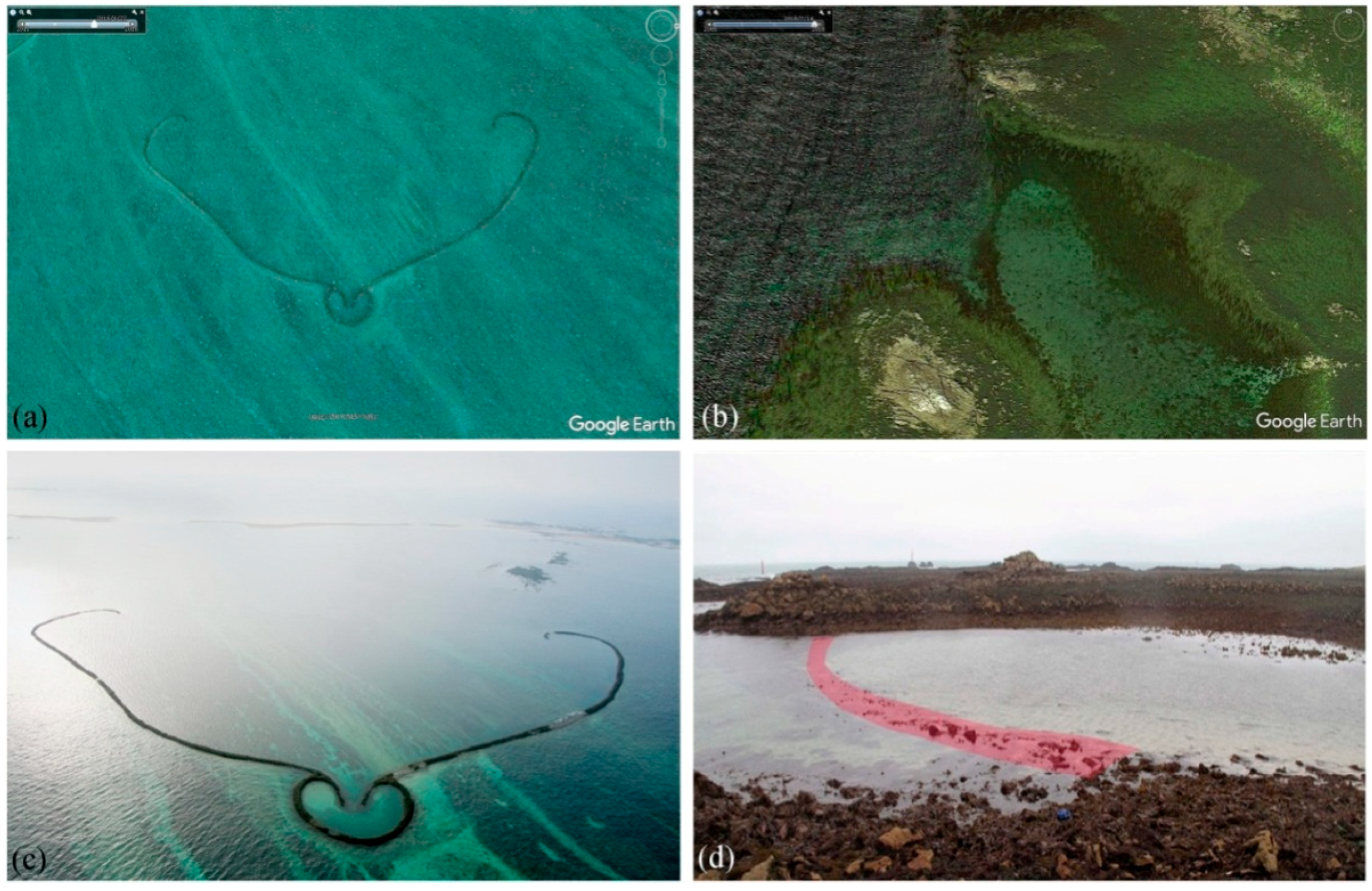
2.1. Study Area and Regional Settings

The Penghu Archipelago is located50 km west of Taiwan Island (Figure 2a) and consists of 90 islands and islets. The average elevation of these islands is limited to 17 m and the highest elevation (79 m) is found in Damaoyu Island in the southwest [2,54]. The base of the Penghu Archipelago is an uplifted basalt mesa, which was formed by the interaction of sea-land uplift, erosion, and volcanic eruptions. In this area, the maximum wave height is 6 to 7 m and themaximum tidal range reaches up to 2.25 m. The average annual wind speed is about 6.1 m/s, and the wind direction is stable. The wind mostly flows northeast from November to April and flows to the south and southwest from June to August.
The Penghu Archipelago is located at the intersection of cold and warm ocean currents, where migratory organisms are known to gather. This configuration allows for numerous fish species to survive and reproduce near the surrounding islands. The coastline in the archipelago is observed to be exposed to erosion by storm waves. Most islands are surrounded by fringing reefs, and the tidal flats occupy large areas ranging up to 37 km2 [55,56]. The archipelago was formed by volcanic activity and has an abundance of basalt and limestone. Local islanders have used these local geologic resources to construct STWs in order to survive in the coastal areas [9]. The Penghu Archipelago has one city and five townships, and Baisha Township in the north has the largest number of STWs. In this area, Chipei Island (Figure 2b) has been historically recognized as the “Land of the Stone Weirs” [57].

2.2. Cultural and Archaeological Contexts

The STWs are locally known as shihu (石沪) and are thought to have originated from Fujian Province in mainland China, perhaps during the Qing Dynasty [23,55,56]. The number of shihu has increased since then and most households have access to one. The STWs enjoyed a golden age before the development of modern-day fishing techniques (Figure 3) and still remain in use today and are leased to companies and cooperatives. STWs of various shapes and sizes are found throughout the Penghu Archipelago. They feature unique construction methods that are representative of a distinctive cultural fishing heritage and the rich natural resources of the local islands.
STWs represent the physical symbols of a dying traditional fishing culture and are precious archaeological and cultural heritage sites for promoting sustainable development in the Penghu Archipelago. These structures represent knowledge, experiences, skills, cultures, and techniques that have been handed down from generation to generation [6]. STW-based fishing also involves the creation and advancement of specific instruments, devices, and tools, and favors the rise and development of other related socio-cultural activities (e.g., residential, sacrificial, astronomical, and dietary) [6,54,55]. In Penghu, STW-based fishing is recognized not only as the act of catching fish and seafood for consumption, but also as a way of interacting with other islanders, understanding life and human nature, and cohabiting with the coastal environment [6,56].

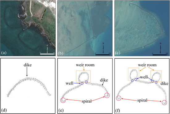
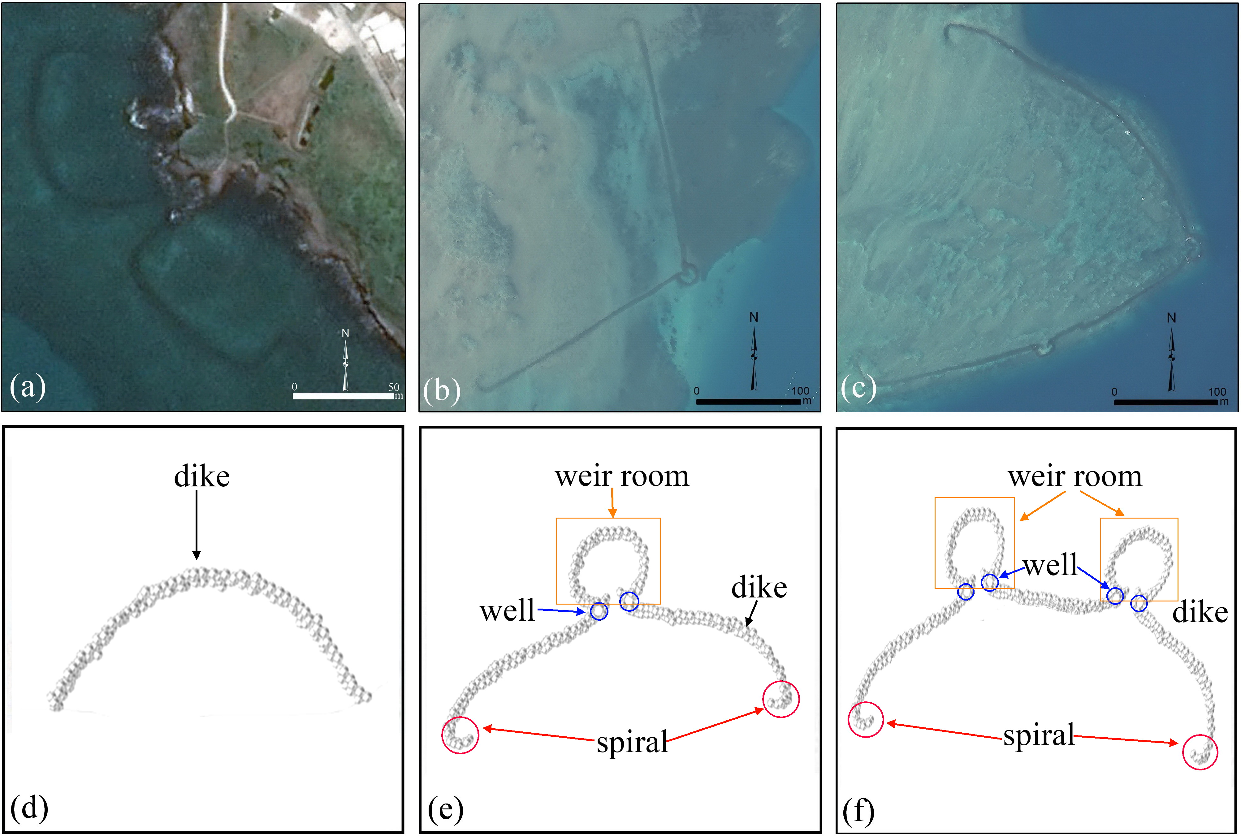
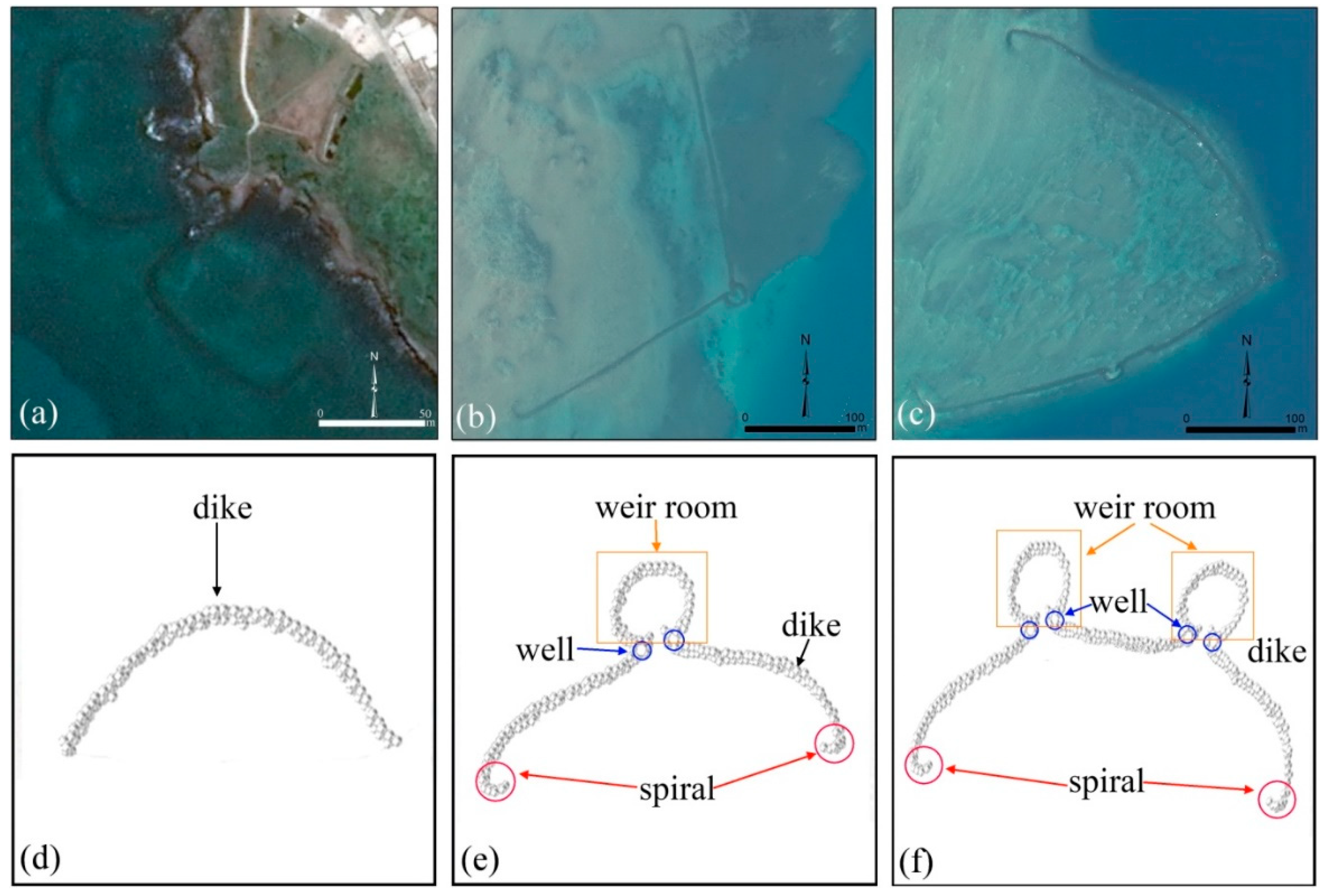
2.3. Morphological Features

The stone tidal weirs in the Penghu Islands can be categorized into three main types: arched (Figure 4a), single-room (Figure 4b), and double-room (Figure 4c) STWs. Different types of stone tidal weirs were attributed to different cultures of adapting the different natural settings, who shared a fishing-centered worldview.
In general, the arched weirs are dustpan-shaped fishing weirs that sit near the coastline. These were constructed in shallower waters and are often called “shallow-plain weirs” [23]. The “plain” term indicates that they have been smoothed into an abrasion platform by waves in the intertidal zone [55]. The water level in arched STWs is low or dry when the tide falls. Only deeper areas have enough water to enable fishing. The single and double-room STWs are necklace-shaped weirs with one or two heart-like weirrooms. They are often built on intertidal flats that are far from the coastline. They are also known as “deep weirs” or “outer weirs” due to their deep water levels and remote location. The primary function and role of the heart-like weir rooms are to catch fish, and they often hold more water than other parts of the weir. Hence, as the tide falls, the fish have no choice but to swim into the weir rooms [23]. The arched stone dike that links the weir rooms often has a half-curved spiral at its end that prevents fish from escaping. The fish swimming along the maze-like dike are thus re-directed back towards the weir rooms [56].

3. Investigation Methods

GE is a fast and effective tool for conducting archaeological surveys at the landscape-scale, where the high-resolution imagery can reveal small or micro archaeological features and traces at about 0.5 m [23,51]. Appreciable sections of the Penghu Archipelago are now available at VHR with lower or nonexistent cloud cover, specifically in the central area and along its western coastline. However, imagery of the northeast section still features high cloud cover and this makes the identification of STWs difficult. GE VHR images were observed to be available for 98% of the intertidal flat areas in the archipelago. Thus, they are ideal sources for investigating STWs.
The discernibility of GE VHR images is improved by searching linear image textures rather than individual image pixels (Figure 5). The STWs are visible as dark linear traces and can be clearly differentiated from ship trails and ebb traces. The linear traces of STWs can be differentiated from tide ebb traces since the center line of an ebb-trace is lighter than the surrounding unscarred intertidal flat surface. Ship trails, in addition, have two or three brighter border lines due to the high reflectance of sunlight.
Based on our previous study [23], the traces of STWs were depicted using the polyline drawing tool in GE drawn over historic VHR imagery. Figure 4c,d reveals images of the STWs, which are represented as red curves. These curves were exported as Keyhole Markup Language (KMZ) files and imported into a geographic information system (GIS). GIS allowed for the storage and management of vector data related to the identified STWs. The KMZ files were then converted into vector polylines in ArcGIS 10.1 using the data management tool. Lastly, STWs on the intertidal flats were mapped, and statistical analyses were performed in a GIS environment.

4. Results and Discussion

4.1. STWs on Penghu Island
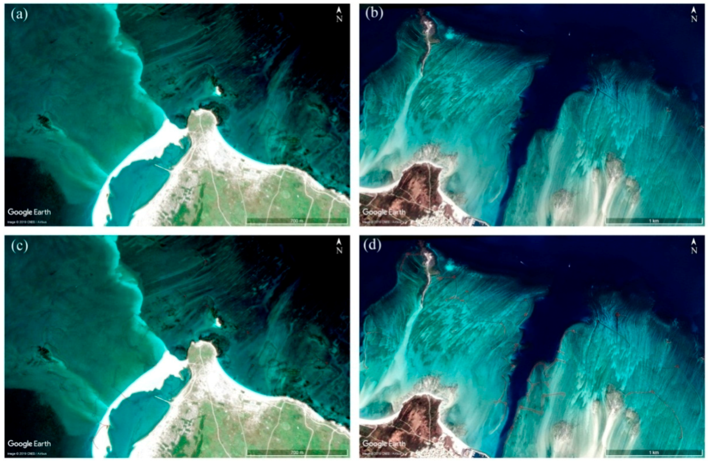
GE allows for the identification of the faint traces of STWs using multi-temporal VHR imagery. The selection of GE images depends on the tidal fluctuations in the Penghu Archipelago. In the summer of 2015, we surveyed the STWs using archived GE VHR data. Our preliminary results (Inventory 2015) revealed that there were 503 STWs [23] distributed along the coastal areas. In the spring of 2018, we carried out the leak finding and data updating of the 2015 STWs Inventory. Our latest results (Inventory 2018) revealed that there were 539 STWs scattered in Penghu coastal areas. Figure 6 reveals the distribution of the identified STWs. The geometry calculator in ArcGIS10.1 was used to calculate STW dimensions. The length of the STWs in the Penghu Archipelago ranged from dozens of meters to hundreds of meters (Table 1), with some surpassing 1000 m. It is worth noting that, the Penghu Archipelago has featured 117 large fishing weirs, consisting of 103 weirs with lengths ranging from 500 to 1000 m and 14 weirs with lengths greater than 1000 m.

4.2. Validations

Several ground-truthed surveys have been carried out for STWs in the Penghu Archipelago during the past 20 years. The results from the surveys produced two valuable but costly investigations. The first investigation consisted of field surveys in the late 1990s by Hong [54]. The second series of surveys were conducted as part of the Digital Archives Program (http://www.daweir.npu.edu.tw) in which field surveys were integrated with airborne photography data [56,57]. The results from these previous studies (around 592 STWs) were used as a reference database in our study. The performance of the GE-based method was evaluated by comparison with these reference databases. Table 2 compares the results for the reference catalog and the GE-based two inventories. There were 311 arched, 254 single-room, and 27 double-room STWs in the ground-truthed reference catalog. In Figure 6a, the red, yellow and violet points denote 279 arched STWs, 236 single-room STWs and 24 double-room STWs, respectively, that were identified and updated using GE and that were present in the reference catalog.

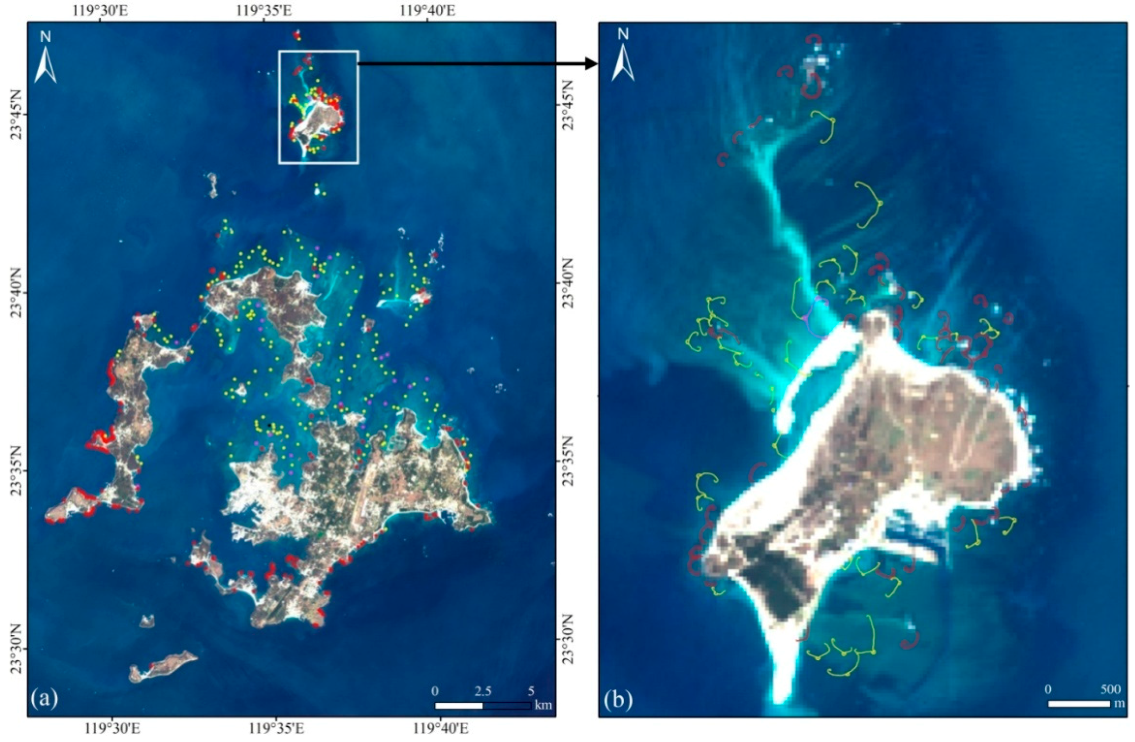
4.3. Spatial Distribution Patterns

Generally, the spatial distribution of fishing weirs was closely related to the fluctuation of ocean tides. The coastal areas that had a large area of intertidal flats usually had higher STW densities. Arched STWs were found to be concentrated on the western and southern coastal areas where the intertidal zones were smaller or nonexistent (Figure 6a). The intertidal zone was mainly distributing in the central inner bay and in the northern areas of the Penghu Archipelago. Single and double-room STWs were found to be concentrated in these areas. Figure 5a reveals how the single and double-room STWs were built along the edge of low tide sub-zones in the intertidal zone (Figure 6b,c). It is worth noting that there were hundreds of STWs distributed in coastal waters around Chipei Island where the intertidal zone can reach several kilometers after the tide ebbs (Figure 5b). Historically, it would have been necessary to consider environmental and landscape conditions when planning the organization and lay-out of STWs. Moreover, the design would have to consider factors such as ocean currents, tidal flows, and physical landscape features. The STWs also featured a range of sedimentary resources, construction materials, and structural morphologies [10,17,56].

4.4. Sustainability

The stone tidal weirs were once one of the most significant means for Penghu to obtain fish and seafood. However, in Penghu, the STWs have been left to degrade and other more productive but less sustainable tools or means have taken their place [20]. These stone structures were symbolized by locals to have fulfilled their historical, cultural and economic role and it was the loss of community support that contributed to their decline [20,56]. However, there has recently been a renewed interest in the conservation of STWs due to the emergence of the tourism economy in Penghu. The Museum of Chipei Village in Baisha Town has emerged as a local site devoted to informing locals and visitors about the fishery, history, culture, value, sustainability, and heritage conservation of STWs [20,54]. The results of this study can be used to construct a virtual museum, which is useful for reconstructing and understanding STW-based fisheries. This can include education on the culture, geography, history, construction, and use and maintenance of STWs. Participants can work in groups to build new STWs within a virtual reality environment and learn more about the religion, culture, marine environment, and the coastal community culture and spirit that were a part of everyday life in historic Penghu [20,56].

4.5. Limitations of GE

The majority (53) of the missed STWs were arched weirs that showed no obvious traces in GE VHR imagery owing to water submersion, especially in the western Penghu Archipelago. Additionally, 18 single-room STWs and three double-room STWs located on the edge of the tidal flats were not identified since they did not have full outlines. The STWs can only be observed by satellite imaging sensors when the tide is low. Moreover, VHR satellite imagery generally has a narrow swath width. The arbitrary timing of GE imagery suggests that certain STWs may not be viewable due to tidal fluctuations. Although GE is a powerful tool for investigating and studying the STWs, traditional and novel survey methods, including field survey, ground remote sensing and aerial reconnaissance (e.g., sonar, unmanned aerial vehicles (UAVs), aircrafts, etc.), must be employed as well to distinguish false positives from regions of interest, and to discover these partial weirs and other missed weirs too vague to be detected reliably by GE VHR imagery. Ideally, a specifically timed UAV-based aerial survey is necessary to inventory these missed sites. GE will not replace the traditional field survey or aerial reconnaissance, but, used judiciously, data gathered by the low-cost GE platforms can rapidly uncover many STWs, the existence of which would not be unsuspected from the ground.

5. Conclusions

This study provided a brief review of GE’s potential applications in archaeology and evaluated the platform’s utility for identifying STWs in the Penghu Archipelago. The STWs were integrated in GIS to analyze their spatial distribution and morphological features. The results were comparable to high-cost field survey data and data obtained from airborne photographic surveys. A total of 539 STWs, 91.07% of all stone weirs in the ground-truthed reference catalog, were identified using GE. However, 53 STWs were not detected using GE imagery since they were submerged by sea water. This large-scale investigation demonstrates that GE is a low-cost, fast, effective and practical tool in archaeological research and in supporting the sustainability of coastal cultural heritage. The fishing STWs distributed on intertidal flats of Penghu Islands will forever deserve our awe and admiration as valuable cultural heritages and a symbol of maritime cultures.

Author Contributions

Conceptualization, L.L. and X.W.; Data curation, X.W.; Formal analysis, L.L.; Funding acquisition, X.W. and W.Z.; Investigation, W.Z. and H.W.; Methodology, L.L.; Project administration, L.L.; Resources, J.L.; Software, H.W.; Validation, L.Z. and C.L.; Visualization, J.Z.; Writing—original draft, L.L.; Writing—review and editing, H.W.

Funding

This work was funded by the Strategic Priority Research Program of the National Natural Science Foundation of China (Grand No. 41801345), the open-fund project of National-Local Joint Engineering Laboratory on Digital Preservation and Innovative Technologies for the Culture of Traditional Villages and Towns and the Chinese Academy of Sciences (Grant No. XDA19030504).

Acknowledgments

The authors thank two anonymous reviewers for their helpful comments and suggestions, which improved this manuscript. Many thanks are given to the Google Earth TM © DigitalGlobe for providing the VHR imagery that was used in this study.

Conflicts of Interest

The authors declare no conflict of interest.

References

  1. Corte, G.; Yokoyama, L.; Amaral, A. An attempt to extend the Habitat Harshness Hypothesis to tidal flats: A case study of Anomalocardiabrasiliana (Bivalvia: Veneridae) reproductive biology. Estuar. Coast. Shelf Sci. 2014, 150, 136–141. [Google Scholar] [CrossRef]
  2. Ting, L. Stone Weirs on Chipei Island, Taiwan: Landesque Capital and Ecologically Unequal Exchange. Master’s Thesis, Lund University, Lund, Sweden, June 2009. [Google Scholar]
  3. Fitzpatrick, S.; Rick, T.; Erlandson, J. Recent progress, trends, and developments in island and coastal archaeology. J. Isl. Coast. Archaeol. 2015, 10, 3–27. [Google Scholar] [CrossRef]
  4. Pichler, H.; Spach, H.; Gray, C.; Broadhurst, M.; Junior, R.; Neto, J. Environmental influences on resident and transient fishes across shallow estuarine beaches and tidal flats in a Brazilian World Heritage area. Estuar. Coast. Shelf Sci. 2015, 164, 482–492. [Google Scholar] [CrossRef]
  5. Howard, P.; Pinder, D. Cultural heritage and sustainability in the coastal zone: Experiences in southwest. Eng. J. Cult. Herit. 2003, 4, 57–68. [Google Scholar] [CrossRef]
  6. Madariaga, C.; Hoyo, J. Enhancing of the cultural fishing heritage and the development of tourism: A case study in Isla Cristina (Spain). Ocean Coast. Manag. 2019, 168, 1–11. [Google Scholar] [CrossRef]
  7. Wikipedia. Available online: https://en.wikipedia.org/wiki/Fishing_weir (accessed on 3 May 2018).
  8. Nishimura, A. Legal conditions of Ishihibi, living fossil of the oldest fishing gear. Co. Law Rev. 1969, 5, 73–116. (In Japanese) [Google Scholar]
  9. Chen, X. Investigation into the stone tidal weirs in the Penghu Islands. Geogr. Res. 1996, 25, 117–140. (In Chinese) [Google Scholar]
  10. Mcniven, I.; Crouch, J.; Richards, T.; Sniderman, K.; Dolby, N.; Mirring, G. Phased redevelopment of an ancient gunditjmara fish trap over the past 800 years: Muldoons trap complex, lake condah, southwestern victoria. Austr. Archaeol. 2015, 81, 44–58. [Google Scholar] [CrossRef]
  11. Erlandson, J.M. The archaeology of aquatic adaptations: Paradigms for a new millennium. J. Archaeol. Res. 2001, 9, 287–350. [Google Scholar] [CrossRef]
  12. Erlandson, J.M.; Graham, M.H.; Bourque, B.J.; Corbett, D.; Estes, J.A.; Steneck, R.S. The kelp highway hypothesis: Marine ecology, the coastal migration theory, and the peopling of the Americas. J. Isl. Coast. Archaeol. 2007, 2, 161–174. [Google Scholar] [CrossRef]
  13. Fitzpatrick, S.M.; Thompson, V.D.; Poteate, A.S.; Napolitano, M.F.; Erlandson, J.M. Marginalization of the margins: The importance of smaller islands in human prehistory. J. Isl. Coast. Archaeol. 2016, 11, 155–170. [Google Scholar] [CrossRef]
  14. Elder, J.T.; Gilmour, D.M.; Butler, V.L.; Campbell, S.K.; Steingraber, A. On the role of coastal landscape evolution in detecting fish weirs: A Pacific Northwest Coast example from Washington State. J. Isl. Coast. Archaeol. 2014, 9, 45–71. [Google Scholar] [CrossRef]
  15. Hritz, C. A malarial-ridden swamp: Using Google Earth Pro and Corona to access the southern Balikh valley, Syria. J. Archaeol. Sci. 2013, 40, 1975–1987. [Google Scholar] [CrossRef]
  16. Langouët, L.; Daire, M. Ancient maritime fish-traps of Brittany (France): A reappraisal of the relationship between human and coastal environment during the Holocene. J. Marit. Archaeol. 2009, 4, 131–148. [Google Scholar] [CrossRef]
  17. Nishimura, A. Living stone tidal weirs of East Asia in transition fossils of fixed fishing gear: Investigation into the relics of stone tidal weirs constructed along the coast of the Miyako Archipelago in Okinawa. Jpn. J. Ethnology 1979, 44, 223–259. (In Japanese) [Google Scholar]
  18. Gandois, H.; Stéphan, P.; Cuisnier, D.; Hulot, O.; Ehrhold, A.; Paul, M.; Dantec, N.; Franzetti, M. The stone tidal fish weirs of the Molène Archipelago, Iroise Sea, Brittany, Western France: A long-term tradition with early megalithic origins. Int. J. Nautical Archaeol. 2018, 47, 5–27. [Google Scholar] [CrossRef]
  19. Tawa, M. Stone Tidal Weirs of East Asia in Transition. Humanit. Rev. 2010, 59, 95–107. [Google Scholar]
  20. Jeffery, B. Reviving community spirit: Furthering the sustainable, historical and economic role of fish weirs and traps. J. Mari. Arch. 2013, 8, 29–57. [Google Scholar] [CrossRef]
  21. Stone Tidal Weirs, Underwater Cultural Heritage or Not? Available online: http://www.themua.org/collections/items/show/1623 (accessed on 27 May 2018).
  22. Luo, L.; Wang, X.; Guo, H.; Lasaponara, R.; Zong, X.; Masini, N.; Wang, G.; Shi, P.; Khatteli, H.; Chen, F.; et al. Airborne and spaceborne remote sensing for archaeological and cultural heritage applications: A review of the century (1907–2017). Remote Sens. Environ. 2019, 232. [Google Scholar] [CrossRef]
  23. Luo, L.; Wang, X.; Liu, J.; Guo, H. Ancient stone tidal weirs in Penghu archipelago: Distribution, category, structure and function, a Google Earth and GIS approach. ISPRS Int. Arch. Photogramm. Remote Sens. Spat. Inf. Sci. 2015, XL-5/W7, 311–314. [Google Scholar] [CrossRef]
  24. Lasaponara, R.; Masini, N. Space-Based Identification of Archaeological Illegal Excavations and a New Automatic Method for Looting Feature Extraction in Desert Areas. Surv. Geophys. 2018, 39, 1323–1346. [Google Scholar] [CrossRef]
  25. Cuca, B.; Hadjimitsis, D. Space technology meets policy: An overview of Earth Observation sensors for monitoring of cultural landscapes within policy framework for Cultural Heritage. J. Archaeol. Sci. Rep. 2017, 14, 727–733. [Google Scholar] [CrossRef] [Green Version]
  26. Stott, D.; Kristiansena, S.; Lichtenberger, A.; Rajac, R. Mapping an ancient city with a century of remotely sensed data. Proc. Natl. Acad. Sci. USA 2018, 115, E5450–E5458. [Google Scholar] [CrossRef] [PubMed] [Green Version]
  27. Xiao, W.; Mills, J.; Guidi, G.; Rodríguez-Gonzálvez, P.; Gonizzi Barsanti, S.; González-Aguilera, D. Geoinformatics for the conservation and promotion of cultural heritage in support of the UN Sustainable Development Goals. ISPRS J. Photogramm. Remote Sens. 2018, 142, 389–406. [Google Scholar] [CrossRef]
  28. Lasaponara, R.; Masini, N. Satellite Remote Sensing: A New Tool for Archaeology; Springer: Berlin, Germany, 2012; pp. 3–16. [Google Scholar]
  29. Luo, L.; Wang, X.; Liu, C.; Guo, H.; Du, X. Integrated RS, GIS and GPS approaches to archaeological prospecting in the Hexi Corridor, NW China: A case study of the royal road to ancient Dunhuang. J. Archaeol. Sci. 2014, 50, 178–190. [Google Scholar] [CrossRef]
  30. Agapiou, A.; Alexakis, D.; Hadjimitsis, D. Spectral sensitivity of ALOS, ASTER, IKONOS, LANDSAT and SPOT satellite imagery intended for the detection of archaeological crop marks. Int. J. Digit. Earth 2014, 7, 351–372. [Google Scholar] [CrossRef]
  31. Palmer, R. Google Maps. AARGnews 2005, 31, 38–39. [Google Scholar]
  32. Ur, J. Google Earth and archaeology. SAA Archaeol. Rec. 2006, 6, 35–38. [Google Scholar]
  33. Myers, A. Camp Delta, Google Earth and the ethics of remote sensing in archaeology. World Archaeol. 2010, 42, 455–467. [Google Scholar] [CrossRef]
  34. Luo, L.; Wang, X.; Guo, H.; Liu, C.; Liu, J.; Li, L.; Du, X.; Qian, G. Automated extraction of the archaeological tops of Qanat Shafts from VHR imagery in Google Earth. Remote Sens. 2014, 6, 11956–11976. [Google Scholar] [CrossRef]
  35. Luo, L.; Wang, X.; Guo, H.; Lasaponara, R.; Shi, P.; Bachagha, N.; Li, L.; Yao, Y.; Masini, N.; Chen, F. Google Earth as a Powerful Tool for Archaeological and Cultural Heritage Applications: A Review. Remote Sens. 2018, 10, 1558. [Google Scholar] [CrossRef]
  36. Yu, L.; Gong, P. Google Earth as a virtual globe tool for Earth science applications at the global scale: Progress and perspectives. Int. J. Remote Sens. 2012, 33, 3966–3986. [Google Scholar] [CrossRef]
  37. Chang, A.; Parrales, M.; Jimenez, J.; Sobieszczyk, M.; Hammer, S.; Copenhaver, D.; Kulkarni, R. Combining Google Earth and GIS mapping technologies in a dengue surveillance system for developing countries. Int. J. Health Geogr. 2009, 8, 1–11. [Google Scholar] [CrossRef] [PubMed]
  38. Parks, L. Digging into Google Earth: An analysis of “Crisis in Darfur”. Geoforum 2009, 40, 535–545. [Google Scholar] [CrossRef]
  39. Trujillo, P.; Piroddi, C.; Jacquet, J. Fish Farms at Sea: The Ground Truth from Google Earth. PLoS ONE 2012, 7, e30546. [Google Scholar] [CrossRef] [PubMed]
  40. Goudie, A. Characterising the distribution and morphology of creeks and pans on salt marshes in England and Wales using Google Earth. Estuar. Coast. Shelf Sci. 2013, 129, 112–123. [Google Scholar] [CrossRef]
  41. Yang, X.; Jiang, G.; Luo, X.; Zheng, Z. Preliminary mapping of high-resolution rural population distribution based on imagery from Google Earth: A case study in the Lake Tai basin, eastern China. Appl. Geogr. 2012, 32, 221–227. [Google Scholar] [CrossRef]
  42. Beck, A. Google earth and world wind: Remote sensing for the masses? Antiquity 2006, 80, 308. [Google Scholar]
  43. Ur, J. CORONA satellite photography and ancient road networks: A northern Mesopotamian case study. Antiquity 2003, 77, 102–115. [Google Scholar] [CrossRef]
  44. Thomas, D.; Kidd, F.; Nikolovski, S.; Zipfel, C. The archaeological sites of Afghanistan in Google Earth. AARGnews 2008, 37, 22–30. [Google Scholar]
  45. Myers, A. Field work in the age of digital reproduction: A review of the potentials and limitations of Google Earth for archaeologists. SAA Archaeol. Rec. 2010, 4, 7–11. [Google Scholar]
  46. Pringle, H. Google Earth shows clandestine worlds. Science 2010, 329, 1008–1009. [Google Scholar] [CrossRef] [PubMed]
  47. Kaimaris, D.; Georgoula, O.; Patias, P.; Stylianidis, E. Comparative analysis on the archaeological content of imagery from Google Earth. J. Cult. Herit. 2011, 12, 263–269. [Google Scholar] [CrossRef]
  48. Kennedy, D.; Bishop, M. Google earth and the archaeology of Saudi Arabia: A case study from the Jeddah area. J. Archaeol. Sci. 2011, 38, 1284–1293. [Google Scholar] [CrossRef]
  49. Sadr, K.; Rodier, X. Google Earth, GIS and stone-walled structures in southern Gauteng, South Africa. J. Archaeol. Sci. 2012, 39, 1034–1042. [Google Scholar] [CrossRef]
  50. Fish Weir—Ancient Fishing Tool of Hunter-Gatherers, an 8000 Year Old Fishing Technology. Available online: https://www.thoughtco.com/fish-weir-ancient-fishing-tool-170925 (accessed on 27 March 2018).
  51. Kempe, S.; Al-Malabeh, A. Desert kites in Jordan and Saudi Arabia: Structure, statistics and function, a Google Earth study. Quatern. Int. 2013, 297, 126–146. [Google Scholar] [CrossRef]
  52. Parcak, S.; Gathings, D.; Childs, C.; Mumford, G.; Cline, E. Satellite evidence of archaeological site looting in Egypt: 2002–2013. Antiquity 2016, 90, 188–205. [Google Scholar] [CrossRef]
  53. Magli, G. The sacred landscape of the “Pyramids” of the Han Emperors: A cognitive approach to sustainability. Sustainability 2019, 11, 789. [Google Scholar] [CrossRef]
  54. Hong, G. Stone Tidal Weirs in Penghu Islands; Penghu Cultural Affairs Bureau: Penghu, China, 1999; pp. 48–218. (In Chinese) [Google Scholar]
  55. Li, M. Origin and Distribution of Fish. Weir Culture, an Exploration with an International Perspective; Penghu Cultural Affairs Bureau: Penghu, China, 2009; pp. 52–64. (In Chinese) [Google Scholar]
  56. Li, M. Stone Weirs of Penghu Islands. China Scenic 2014, 5, 109–118. [Google Scholar]
  57. Li, M.; Zhan, Y. Digital archives program of Penghu stone tidal weirs. Coral Stone 2006, 44, 2–19. (In Chinese) [Google Scholar]
Figure 1. Stone tidal weirs in the Penghu Archipelago, China (left panel), and Molène Archipelago, France (right panel). The two Google Earth (GE) images were acquired on (a) 22 June 2016 and (b) 14 July 2018. (c) The aerial photo of (a) which can be downloaded from http://museum02.digitalarchives.tw/ndap/2005/StoneTidalWeir/www.daweir.npu.edu.tw/searchstw_pic_view7a3f-2.html?sn=2654, accessed on 12 January 2018. (d) A ground photo of (b) is shown on the bottom right [18].
Sustainability 11 04536 g001
Figure 2. The Penghu Islands at (a) regional and (b) local scales. The base map consists of Landsat-7 Enhanced Thematic Mapper Plus (ETM+) imagery that can be downloaded from http://www.usgs.gov.
Sustainability 11 04536 g002
Figure 3. (a) A 1934 map of a stone tidal weir fishing ground (http://museum02.digitalarchives.tw/ndap/2005/StoneTidalWeir/www.daweir.npu.edu.tw/searchaob01view14cb.html?sn=7, accessed on 1 December 2018) and (b) a photocopy of a stone tidal weir fishing license from 1859 (http://museum02.digitalarchives.tw/ndap/2005/StoneTidalWeir/www.daweir.npu.edu.tw/searchaob02viewdb91.html?sn=12, accessed on 1 December 2018).
Sustainability 11 04536 g003
Figure 4. Upper panel shows GE images for three typical stone tidal weirs (STWs), including (a) arched, (b) single-room, and (c) double-room STWs. The lower panel shows schematic views corresponding to the GE images on the upper.
Sustainability 11 04536 g004
Figure 5. (a) GE imagery of STWs in Chipei Island (© 2019 Digital Globe, acquired on 22 July 2013) and (b) Husi Island (© 2019 Digital Globe, acquired on 16 February 2017). The top panel includes the original GE that depicts intertidal flats. In the bottom panel (c,d), red lines are used to mark the positions of STWs.
Sustainability 11 04536 g005
Figure 6. Spatial distribution of STWs (2018 Inventory) on the Penghu Archipelago (left) and Chipei Island (right). Red, yellow, and pink symbols represent arched, single, and double-room STWs, respectively. The base map consists of Landsat-8 OLI imagery that can be downloaded from http://www.usgs.gov.
Sustainability 11 04536 g006
Table 1. Size comparison of STWs in the Penghu Archipelago.
CategoriesSize in Length (m)
(0, 100)(100, 300)(300, 500)(500, 1000)>1000
Arched741881700
Single749818910
Double024144
Total8123910210314
Table 2. A comparison of STWs identified using GE with the reference catalog.
Types2015 Inventory2018 Inventory
GE (G)Reference (R)G/R×100%GE (G)Reference (R)G/R×100%
Arched25231181.0327931189.71
Single22725489.3723625492.91
Double242788.89242788.89
Total50359284.9753959291.04

