Article

Land Degeneration due to Water Infiltration and Sub-Erosion: A Case Study of Soil Slope Failure at the National Geological Park of Qian-an Mud Forest, China

Construction Engineering College, Jilin University, Changchun 130026, China
*
Author to whom correspondence should be addressed.
Sustainability 2019, 11(17), 4709; https://0-doi-org.brum.beds.ac.uk/10.3390/su11174709
Submission received: 7 August 2019 / Revised: 25 August 2019 / Accepted: 26 August 2019 / Published: 29 August 2019
(This article belongs to the Section Sustainability in Geographic Science)

Abstract

:
Sustainable development of the natural landscape has received an increasing attention worldwide. Identifying the causes of land degradation is the primary condition for adopting appropriate methods to preserve degraded landscapes. The National Geological Park of Qian-an mud forest in China is facing widespread land degradation, which not only threatens landscape development but also endangers many households and farmlands. Using the park as a research object, we identified the types of slope failure and the factors that contribute to their occurrence. During June 2017, a detailed field survey conducted in a representative area of the studied region found two main types of slope failure: soil cave piping and vertical collapse. Physicochemical properties of the soil samples were measured in the laboratory. Results show that soil slope failure is controlled by three factors: (1) the typical geological structure of the mud forest area represented by an upper layer of thick loess sub-sandy soil and the near-vertical slope morphology; (2) particular soil properties, especially soil dispersibility; and (3) special climate conditions with distinct wet and dry seasons.

1. Introduction

Recently, the sustainable development of natural landscapes has received an increasing attention worldwide. Sustainability studies of landscapes have evolved into a vibrant research field, especially since 2004–2006 [1]. The landscapes of a territory are the consequence of its history [2] and the result of biodiversity distribution in accordance with physiographic and structural traits [3,4]. It is important to explore the nature of landscape change [5]. Aiming for landscape sustainability science to move forward, it needs to integrate landscape sustainability into other disciplines. Emphasizing both “linking knowledge to action” and “understanding human-environment interactions,” is the essence of sustainability science [1]. Land degradation occurs in all types of landscapes over the world [6]. Concerning the face of mounting changes and threats to landscapes [7], we should be keenly aware of this challenge [8]. The threat to sustainable development caused by land degradation was explicitly recognized at the 1992 Earth Summit and 2002 World Summit on Sustainable Development [9]. Land degradation involves deterioration in soil properties related to crop production, infrastructure maintenance, and natural resource quality [10,11]. It also is associated with the decline in the productivity of ecosystems over time [12]. Approximately 60% of the world’s land area is regarded as degraded and land degradation, including soil erosion, is one of the greatest challenges for land managers [11,13].
Soil erosion is not only a geomorphological but also a land degradation process that may cause environmental damage affecting people’s lives [14,15]. Ebabu et al. [16] regarded soil erosion as a major cause of land degradation in different regions of the world. Chalise et al. [11] pointed out that land degradation, particularly soil erosion, is currently a major challenge for Nepal, and rainfall infiltration is thought to accelerate land degradation. Soil erosion by water is also one of the major threats to soils in the European Union, with a negative impact on ecosystem services, crop production, and drinking water [17]. Similarly, land degradation due to soil erosion is a major challenge in Africa [18]. Although land degradation occurs in all kinds of landscapes over the world, the drivers of land degradation vary from region to region [6]. Generally, soil erosion results in the loss of nutrients and fine particles as well as desertification in most semi-arid areas [19,20,21]. The loess region of China also has suffered from serious soil erosion for years [19]. Found in loess areas, mass movement is very typical and characteristic. The occurrence of mass movement is controlled by a series of internal and external factors, such as rainfall [22,23,24]. Dry loess can sustain near-vertical slopes; however, a loess area can rapidly disaggregate when locally saturated by rainfall [25] and, thus, a loess slope is highly prone to mass movement processes [26]. Mass movements are common and typical and in loess areas, especially following intense rainfall or prolonged rainfall [27]. Mass movement involves multifarious movement types, and several classification systems for mass movements have been developed [28]. Varnes [29] developed a mass movement classification based on the material (mud, soil, earth, rock, and debris) and movement type (falls, topples, slides, lateral spreads, and flows). Varnes [29] also proposed a further movement type, which he named complex, this type is a combination of two or more principal types of movements [30]. Based on geometry and movement mechanisms, mass movement also can be divided into four categories: bedrock contact landslides, palaeosol contact landslides, mixed landslides, and slides within loess [31]. Xu et al. [32] suggested a systemic classification of loess landslides, including slides, flows, and combined loess and bedrock landslides. Abramson et al. [33] recognized five types of mass movement: falling, toppling, sliding, spreading, and flowing, however, there are few researches on the type of mass movement caused by sub- erosion. Sub-erosion generally refers to various forms of erosion caused by groundwater below the surface [34,35]. Li et al. [35] pointed out that under the action of sub-erosion, the loess soil slope failure with caves mainly is divided into three types: the formation of a cave or cave system and its subsequent deformation and failure; the whole or partial deformation of slope due to the existence of caves; and the subsequent transformation of newly created caves on the slope failure due to rainfall after the overall slope failure.
The National Geological Park of Qian-an mud forest in China is used as the research object in this study. Qian-an mud forest was officially approved as a national geological park in 2009. Due to its unique landform (Figure 1) caused by sub-erosion, this landscape has become the only protected “mud forest” site in China with these geological features, giving the area a high aesthetic and scientific investigation value. Soil slope failure is a direct and main form of land degradation in the mud forest area. Recently, soil slope failure has become increasingly serious, and the destruction trend is evident. Observed in this area, sub-erosion is the main process of soil slope failure, causing damage to its unique and beautiful landscape and leading to soil mass failure. The destruction scope of the soil slope reaches over 5 km. Soil mass failure threatens numerous households and farmlands in the vicinity (Figure 2), as well as the development of the mud forest geological park. This limits the sustainability of the mud forest landscape and local agriculture. The mud forest landscape has distinctive features. It is rare at home and abroad. It is a geological landscape of great ornamental and research value [34]. To make it provide landscape services in a long and stable way, we must understand the causes of landscape degradation. Agricultural income is the main source of income for local residents. Accompanying the expansion of the destruction range of the soil slope, the cultivated land area decreases. Timely suppression of land degradation promotes local sustainability. Several studies have been conducted on the mud forest area, most of which focused on the formation of the mud forest landscape. Take, for example, Zhou et al. [36] who considered the area a peculiar geological landscape formed by the combined action of various geological factors. They proposed the view of protecting the landscape. Chi et al. [37] presented that the mud forest formation is not only related to internal and external dynamic geological processes, but also closely related to the soil composition. Zhu et al. [38] divided the formation of mud forest landforms into four periods. Few studies, however, have focused on the slope failure of the mud forest at its current condition. During 2013, certain control measures were implemented in locations that posed the highest threats to residential area, such as cutting slopes, spraying concrete, and anchorage, however, these measures ultimately failed because the influence of sub-erosion has been neglected. Slope failure was not controlled, and the local landscape was damaged severely. Thus, the causes of soil slope failure must be clearly investigated.
Two typical types of slope failure are found in the mud forest area, namely, soil cave piping and vertical collapse. According to the classification mode, the former is characterized by the subsequent transformation of newly created caves on the slope failure due to rainfall after the overall slope failure, while the latter is characterized by sliding. We realize that the failure factor of soil slope is closely related to geological structure, topographic conditions, soil physicochemical properties, and climatic conditions.

2. Materials and Methods

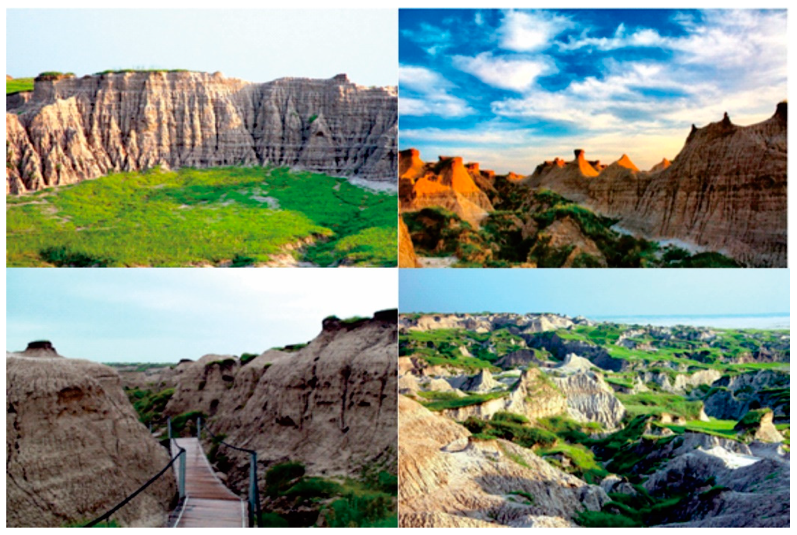
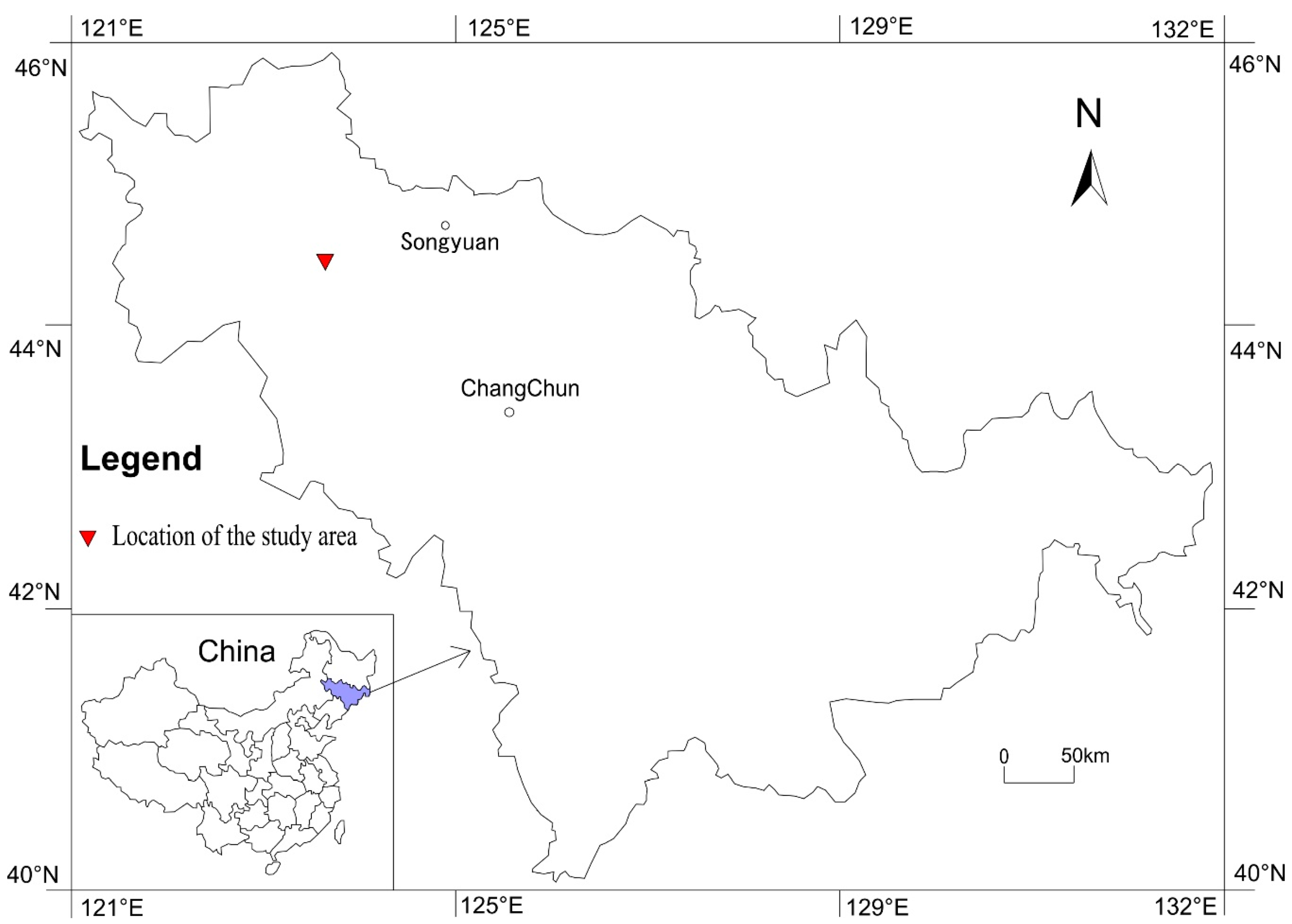
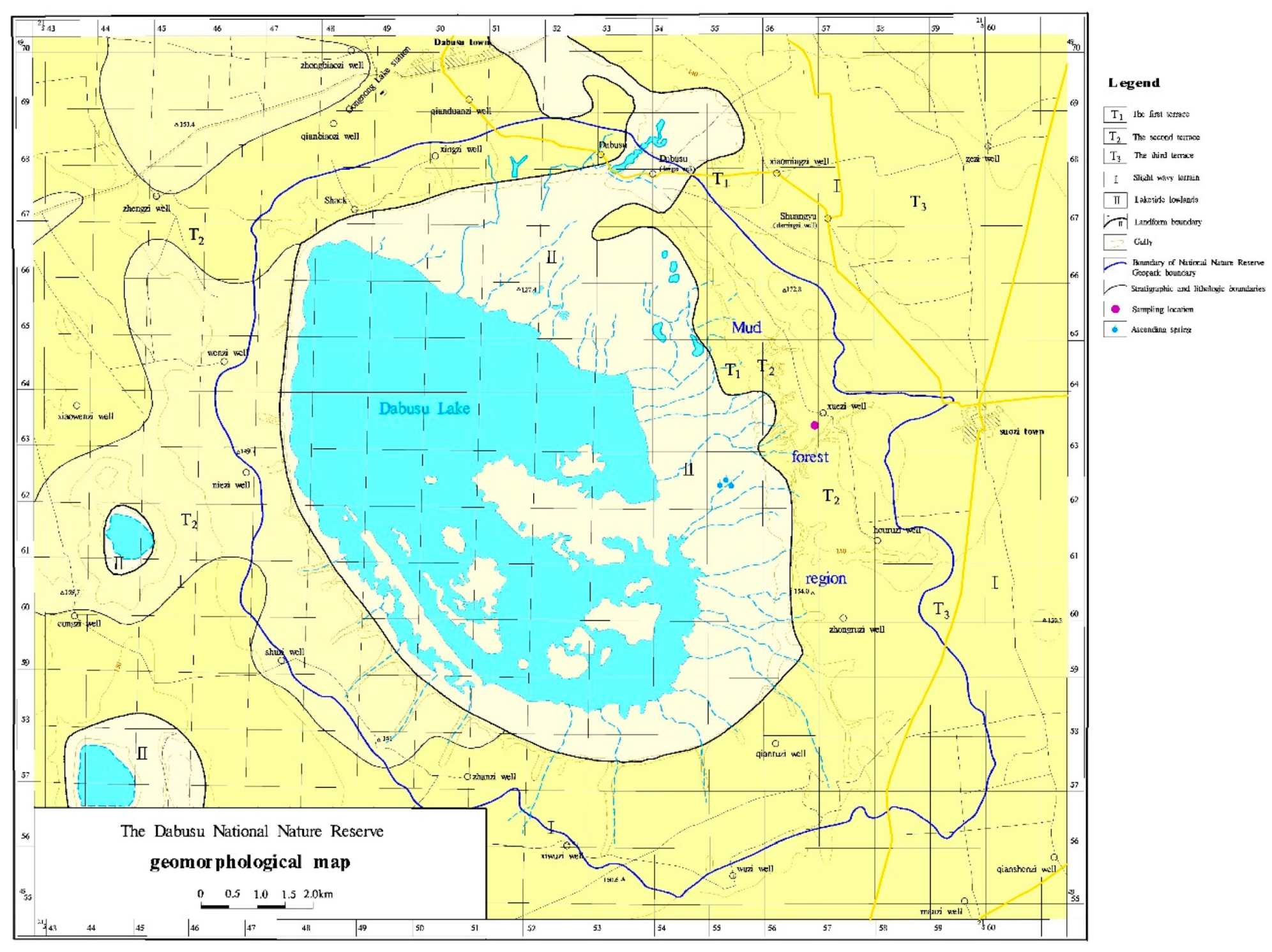
2.1. Description of the Study Area

The National Geological Park of Qian-an mud forest (123°36′−123°42′ E, 44°45′−44°50′ N, covering an area of more than 110 km2) is located in the northwest part of Jilin Province, China (Figure 3). The mud forest region is distributed in the western alluvial plain of the Songnen plain, where the terrain is inclined from east to west and from south to north due to the influence of neotectonic movement. This inclination resulted in the absence of modern rivers on the Qian-an terrace plain, however, numerous depressions, lakes, and marshes left over from ancient rivers formed relatively independent closed flow areas as they permeated and supplied each other. Preliminary statistics shows that nearly 700 lakes exist within an area of over 6 km2, including the large Dabusu Lake, which is a typical and representative inland lake.
The Qian-an mud forest region is distributed mainly in the secondary terrace of the Dabusu Lake basin (negative topography) (Figure 4). The trend of the lake basin is high and steep in the east but low and gentle in the southwest, with a relative height difference of 30 m. The secondary terrace elevation is approximately 150–160 m, whereas the first is approximately 140 m, and the lowest point is approximately 119.1 m. Based on the regional stratigraphic sequence, the geological age of this region is very late Pleistocene. The upper layer comprises thick loess sub-sandy soil.
The study area has a typical temperate continental monsoon climate with four distinct seasons where drought and semi-drought coexist. The annual average precipitation is approximately 400 mm, nearly 70% of which is concentrated in June, July, and August. The annual average evaporation is approximately 1800 mm, which is 4.5 times higher than the amount of annual average precipitation [40]. The annual average temperature is 4.6 °C with extremely high temperatures varying from 30 °C to 35 °C and low temperatures ranging from −30 °C to −23 °C.
Vegetation in the study area is characterized by meadow steppes. The current vegetation types are mainly from the stipe grass group, white thorn community, reed community, erigeron community, and crops.

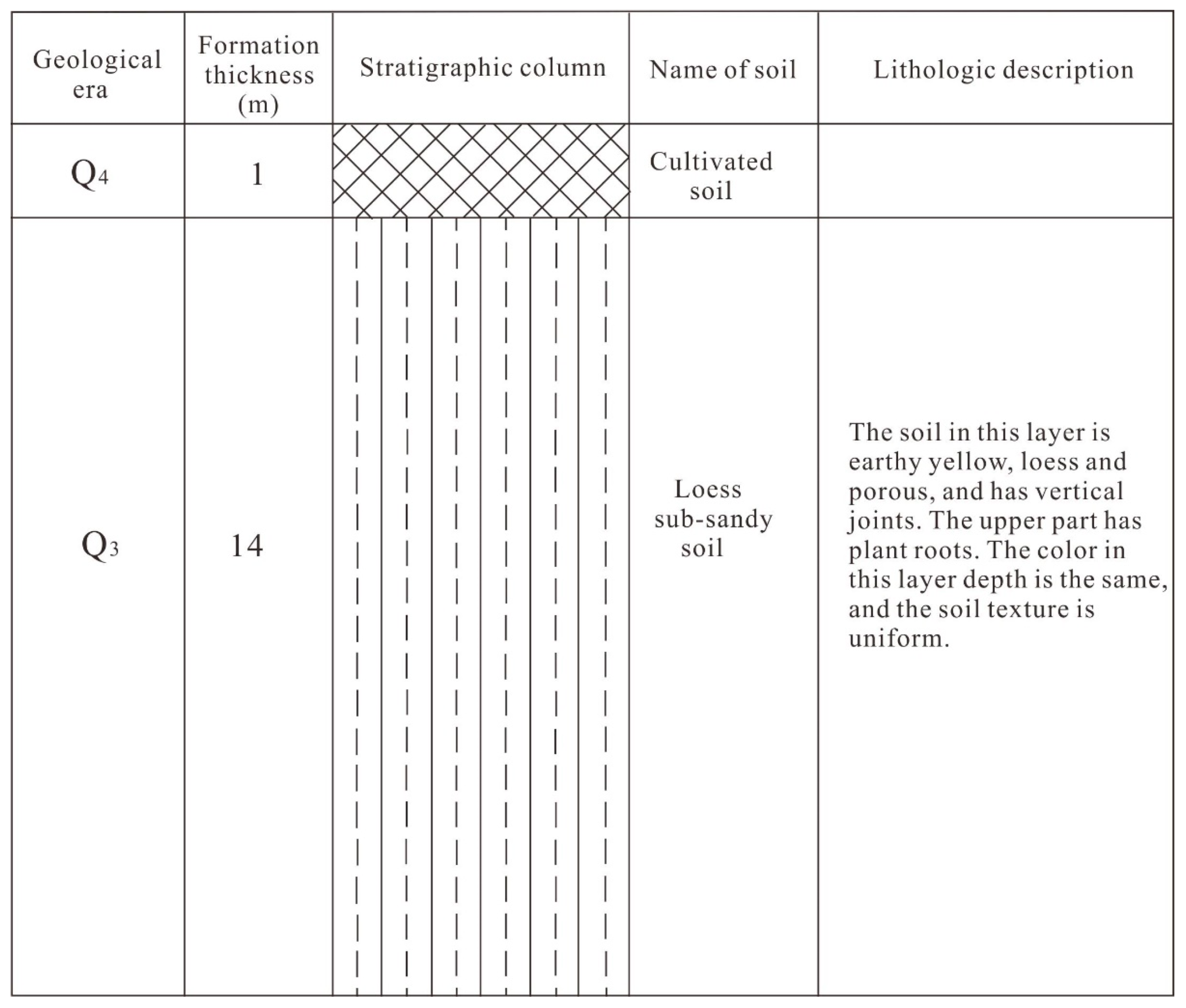
2.2. Field Survey and Sampling

A detailed field survey was conducted in a representative part within the study area that experiences severe erosion. Observations show that soil slope failure is a main process of land degradation and the extent of slope damage is serious. The failure types of the slope are classified. The slope also was observed, and its height was recorded using a tape measure. According to the drill disclosure, we drew the drill column as shown in Figure 5. The loess sub-sandy soil had a thickness of 14 m, with a top of 1m and a bottom of 15 m. Each sample was collected every two meters, for a total of eight samples, namely C1–C8, respectively. The location of the sampling point can be seen in Figure 4. Meanwhile, a sample of underground water was taken.

2.3. Laboratory Test

Soil samples were analyzed for grain size, physical properties, such as moisture content, density, porosity, liquid limit moisture content, and plastic limit moisture content. Grain size composition was determined through the densitometer method, whereas moisture content was calculated through the oven drying method. The density of samples was measured through the cutting ring method. Porosity was determined through the mercury injection method, and the limit moisture content was measured through the combined method of liquid and plastic limits. Qualitative mineralogy was measured using a D2700 diffractometer. The crystalline composition was estimated quantitatively through a method that combines chemical and diffractometric data [41,42]. Regarding terms of soil chemistry, major elements were determined via X-ray fluorescence spectrometry following the analytical procedure of Franzini et al. [42] and Leoni and Saitta [43]. This method uses powder pellets and is based on the full matrix correction method. Total volatile components (H2O+ and CO2) were determined as loss on ignition (LOI) at 950 °C on powders dried at 105 °C [44,45,46]. The sample C8 was selected as the test object, its PH value and soluble salt content were measured. PH was determined using a PHS-3C instrument. The type and amount of cations and anions present in the sediment pore water were assessed. Sediment at natural moisture content was mixed with sufficient distilled water to reach the liquid limit. This sediment water system was left to stand overnight to establish equilibrium. Then, 10–25 mL of pore water was extracted from the saturated sediment paste. This saturation extract was analyzed for the main cations (Na+, K+, Ca2+, and Mg2+) and anions (Cl, HCO3 and SO42−) through Dionex Dx-120 ion chromatograph. SAR, PS, and TDS were then calculated using the soluble salt content to analyze the soil dispersion. The chemical composition of the water sample was tested.

3. Results and Discussion

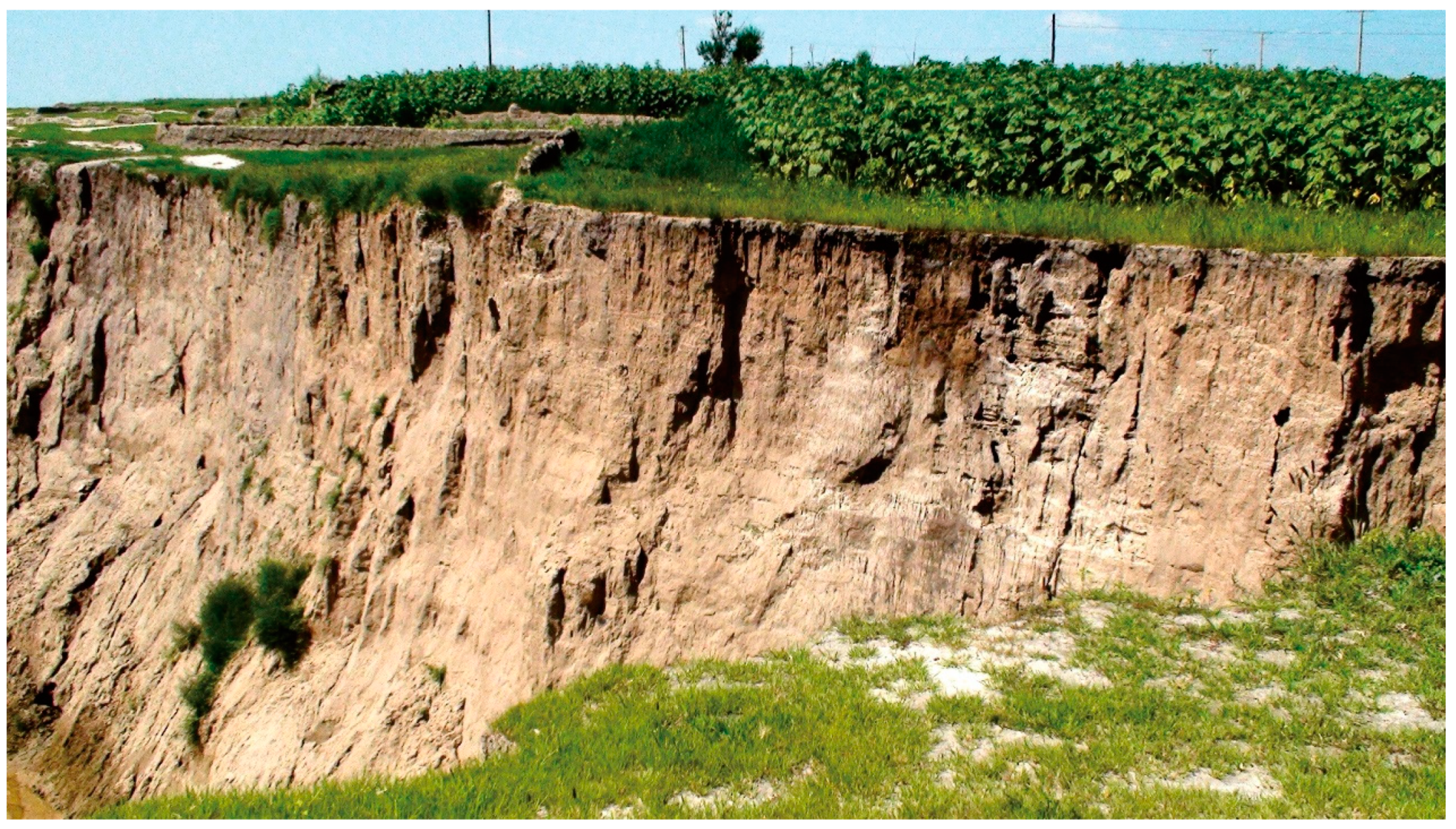
3.1. Types of Soil Slope Failure in the Mud Forest Area

The failure mode of soil slope is classified in accordance with their different failure mechanisms. Two main types of soil slope failures were found in the study area: soil cave piping (Figure 6) and vertical collapse (Figure 7).

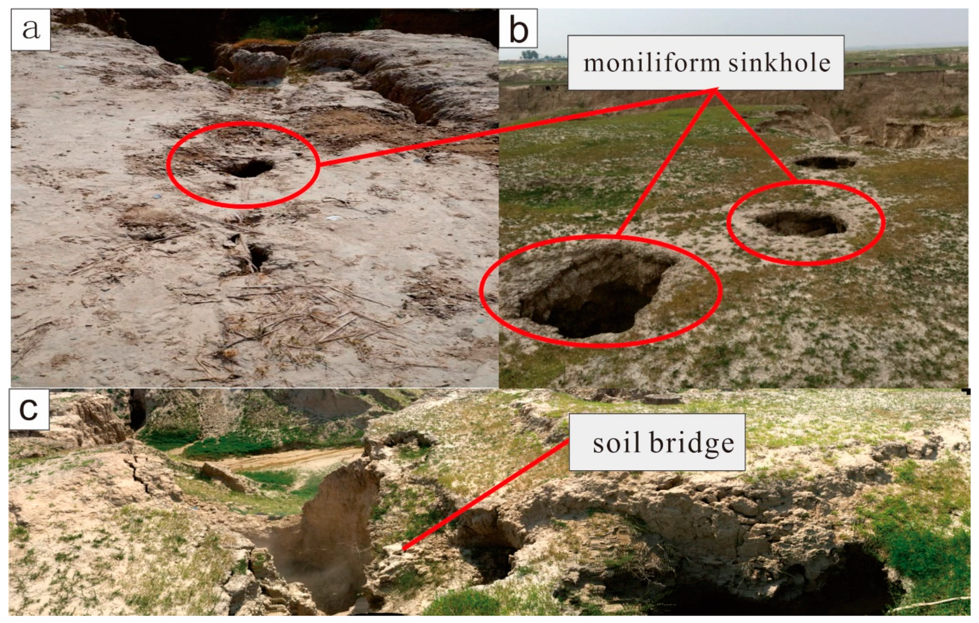
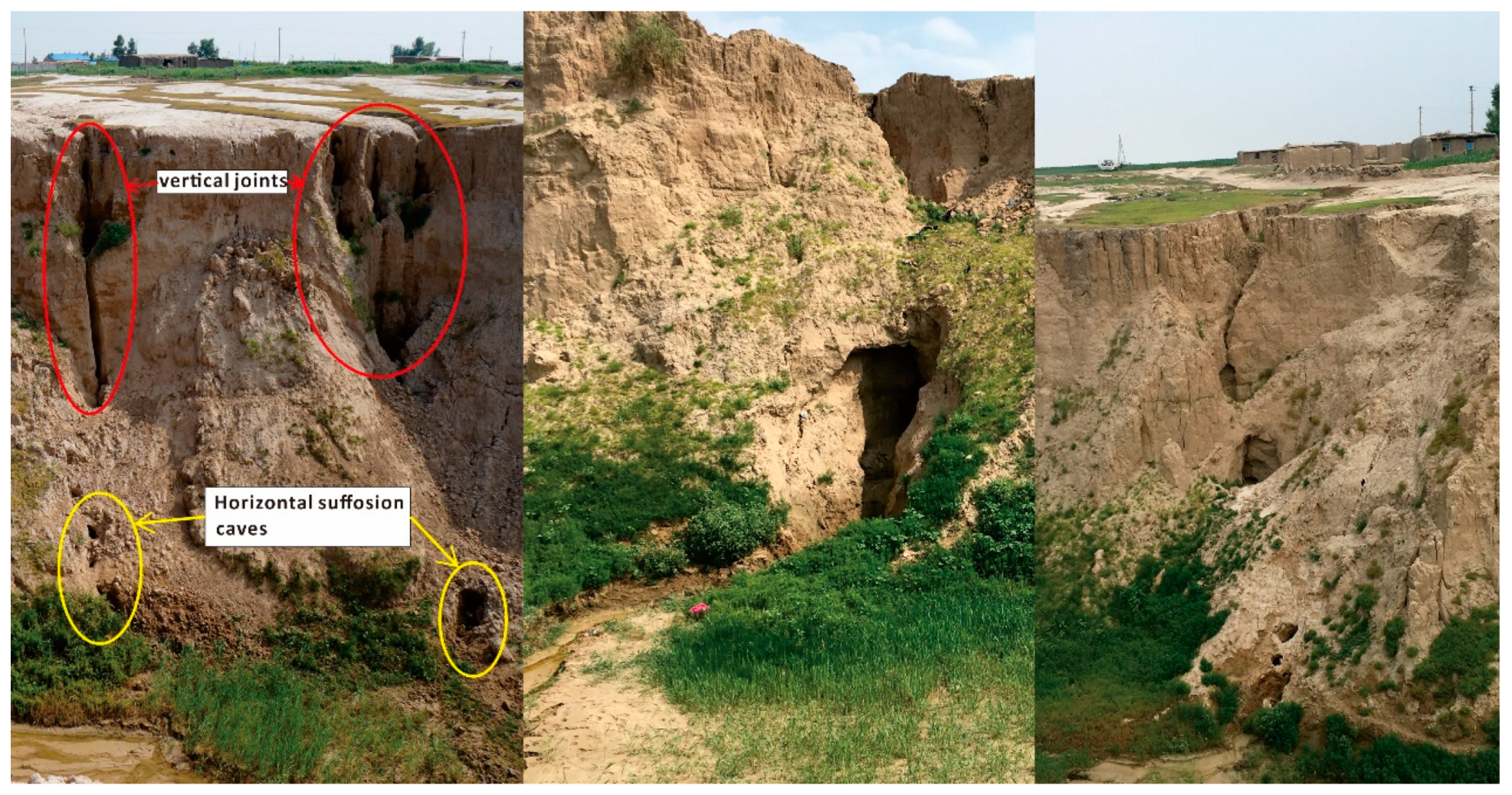
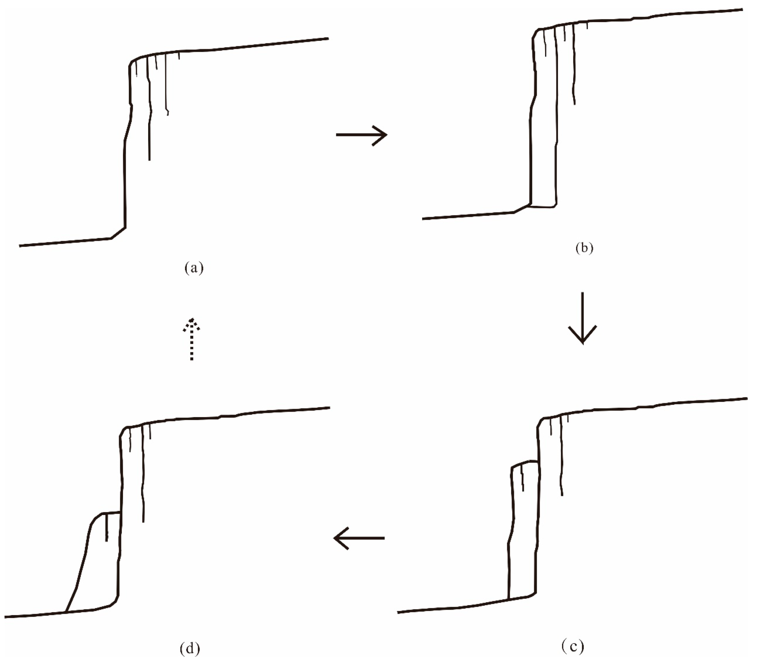
3.1.1. Soil Cave Piping Failure of Slope

Soil cave piping failure of a slope is particularly common in the mud forest area. During the rainy season, surface water collects in negative landforms and penetrates downward along the vertical joints. Surface water infiltration is the source of piping failure. Accompanying erosion, the ground surface gradually forms geomorphic features, such as moniliform sinkholes (Figure 6a,b) and soil bridges (Figure 6c).
During the transfixion of sinkholes, surface water stops penetrating the soil at a certain depth and discharges toward the free face together with groundwater. Meanwhile, horizontal suffosion caves or channels are formed at the foot of the slope (Figure 8), leading to slope failure.

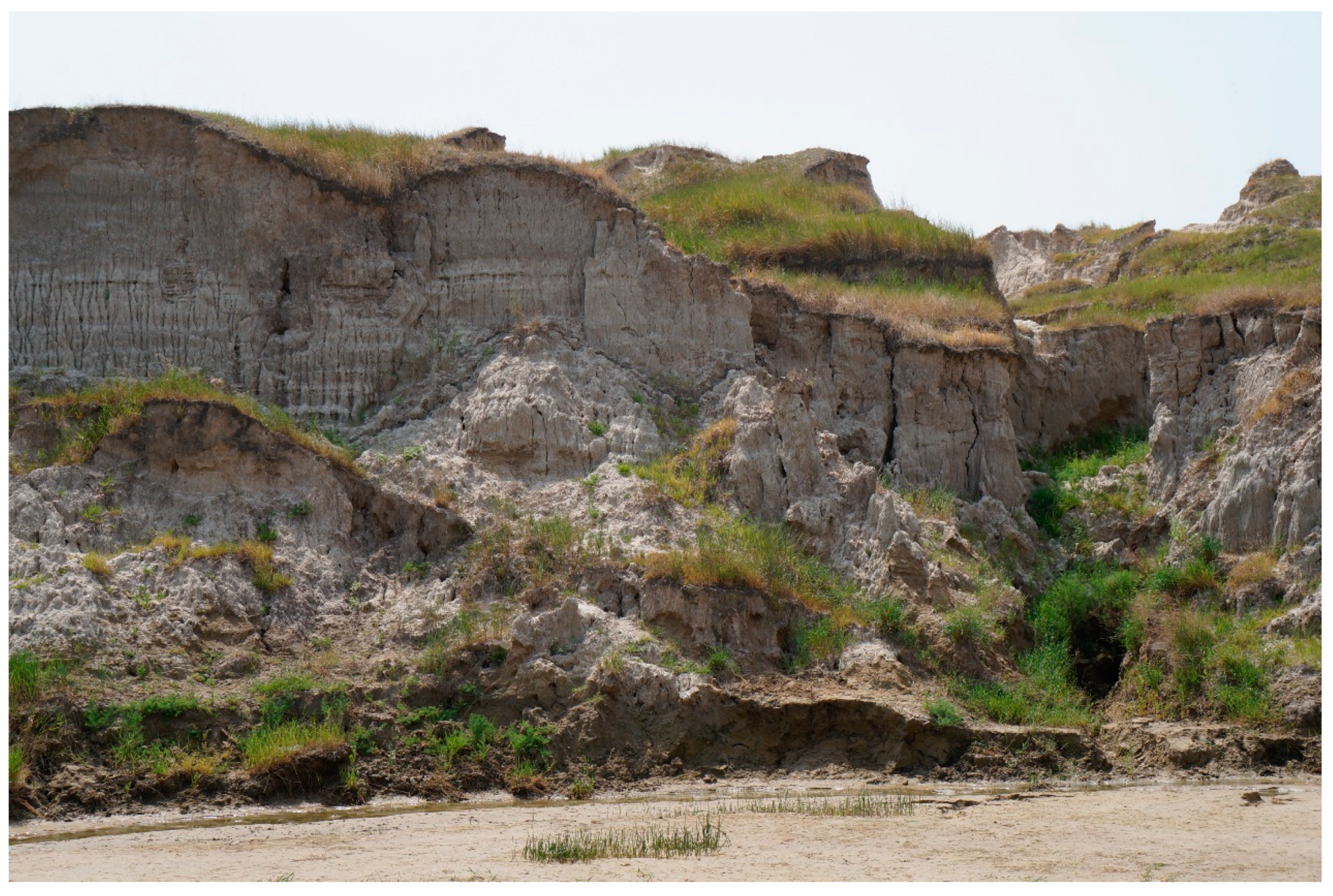
3.1.2. Vertical Collapse of Slope

Vertical collapse is another common form of slope failure in the mud forest area (Figure 7). Surface water infiltrates along the vertical joints (Figure 9a), and vertical cracks are wide and deep. The water infiltration reduces the shear strength of the soil and cutting forms vertical layered or columnar soil (Figure 9b). Occurring at a certain depth, surface water stops penetrating the soil and discharges toward the free face together with groundwater. Water seepage infiltrating along the vertical cracks promotes the movement of loose particles near the foot of the slope, which forms a seepage channel. Horizontal seepage forms hollowed zones at the bottom of the layered or columnar soil. Finally, a staggered collapse occurs due to the sheer force of free face soil and the self-weight of the overlying soil (Figure 9c). Following the free face of the soil slope collapse (Figure 9d), a new free face is exposed, which results in cyclical slope failure. While the accumulation of soil gradually is carried away by gully river scouring, vertical collapse of slope continues to occur.

3.2. Factors Controlling Slope Failure

The mud forest landscape not only has the aesthetic experience of landscape, but also can increase the geological knowledge for tourists. It is a rare geological landscape in the world. However, from the perspective of the ecological environment and geological disasters, it is very fragile [36]. The landscape is suffering from the two failure forms mentioned above. To develop the geological landscape resources of mud forest sustainably, it is necessary to figure out how to coordinate natural geological phenomena with geological problems. The slope failure has reduced the area of cultivated land which has led to a reduction in land use efficiency, which threatens local economic development. According to the research, we found that the failure factor of soil slope closely is related to geological structure, topographic conditions, climatic conditions, and soil physicochemical properties.

3.2.1. Geological Structure and Topography

Approximately 20,000 years ago, in the early to late Pleistocene, the function and influence of neotectonic movements caused the ground to rise gradually and tilt toward the northwest. The Huolin River gradually moved toward the north, and with lake basin areas shrinking and differentiating, the Dabusu Lake was formed as a residual lake. During the neoid period, the earth’s crust rose several times, especially tilted toward the northwest with numerous fault activities. Thus, the banks of the Dabusu Lake basin had asymmetric topography characteristics, with the gully on the east bank further developed with strong erosion and sub-erosion. This phenomenon was the basis of the formation of the mud forest area and also was the geological structure factor of the soil slope failure. Geotectonically, the mud forest area belongs to a depressed part of the Songnen plain. Since the Miocene era, this basin-like plain has been subsiding and accumulating thick Mesozoic sediments continuously. Drilling revealed that the upper part of the Songnen plain is loess sub-sandy soil with large pores and abundant vertical cracks, and the visible thickness of this layer is greater than 21 m.
Field observation and measurements reveal that, on the surface, there are many negative terrains, such as pits. These negative terrains are conducive to rainfall accumulation. Subsequently, the accumulation of rainwater promotes the occurrence of sub-erosion. This accelerates the process of soil cave piping failure. The occurrence of mass failure depends on the characteristic of landforms, which can be represented by slope gradient, slope height and slope surface morphology [47]. Generally, the larger the slope gradient and the higher the slope height, the more likely vertical collapse will occur. The angle of the soil slope in the mud forest area is nearly vertical, and the slope height ranges from 15 m to 21 m. This creates topographic conditions for the vertical collapse of the slope. Generally, terrain slope profiles may be grouped into three types: plane, concave, and convex [47]. Most of the soil slopes in the mud forest are concave, which are prone to runoff accumulation and erosion. The especially developed vertical crack of the soil slope becomes an important reason for the vertical collapse of slope. These vertical cracks provide channels for precipitation infiltration. Following the infiltration of rainfall, the crack expands. Consequently, soil shear strength decreases, and vertical collapse occurs. Vertical fissures and beaded drop holes are evident on the free face of the slope, and the failure range of soil slope increases annually in an apparent trend.

3.2.2. Climatic Conditions

Rainfall plays an important role in stimulating the destruction of soil slopes [48]. Given that rainfall is concentrated into short periods of time, most geomorphic work (e.g., soil erosion) occurs in short temporal intervals [49]. Occurring in the mud forest region, the dry season lasts for 8 months. The total annual average precipitation is 404 mm (Table 1), over 80% of which falls during the wet season (from June to September). Thus, the precipitation in this area is particularly concentrated. The total annual average evaporation is approximately 1800 mm. The concentrated precipitation in a short period makes the surface soil vulnerable to erosion and the long drought season facilitates the development of abundant vertical joints and cracks in the soil material surface [50]. The cracks in the soil gradually enlarge and widen under the action of dry–wet circulation and erosion.
The rain soaks the soil for a long time, in the concave surface terrain, and the soil underneath is eroded at the same time, on the one hand. The infiltrating surface water carries away the fine particles in the soil and weakens its cementation strength, which expands the pore volume of the soil. The overlying soil body collapses and, thus, the process of soil cave piping failure is accelerated.
Rainwater enters the inner soil body via cracks along the numerous vertical joints and tends to weaken the soil consistence, on the other hand. The vertical joints expand due to rainwater infiltration and sidewall soil body cutting. The soil body absorbs part of the rainwater entering the cracks, increasing the sidewall weight, which becomes an important reason for its sliding. The sidewall slide finally leads to the vertical failure of the slope. The rainy season is also a high temperature period. The cycle of rainfall and evaporation occurs. It is also a wet and dry cycle. Dry–wet circulation leads to soil fracture expansion, which is more conducive to rainfall infiltration [50]. This is also an important reason for slope vertical collapse.

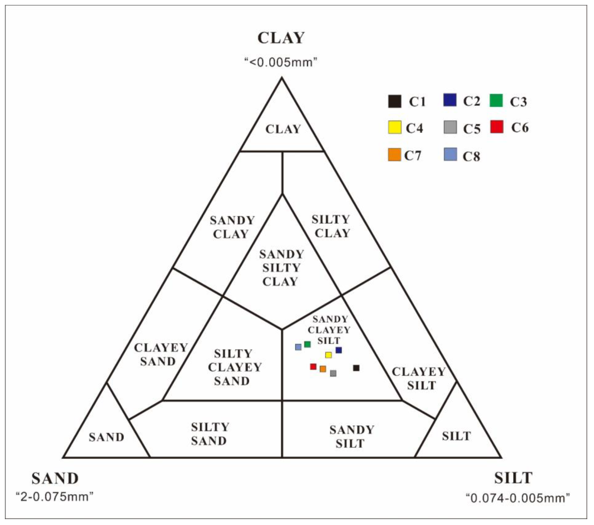
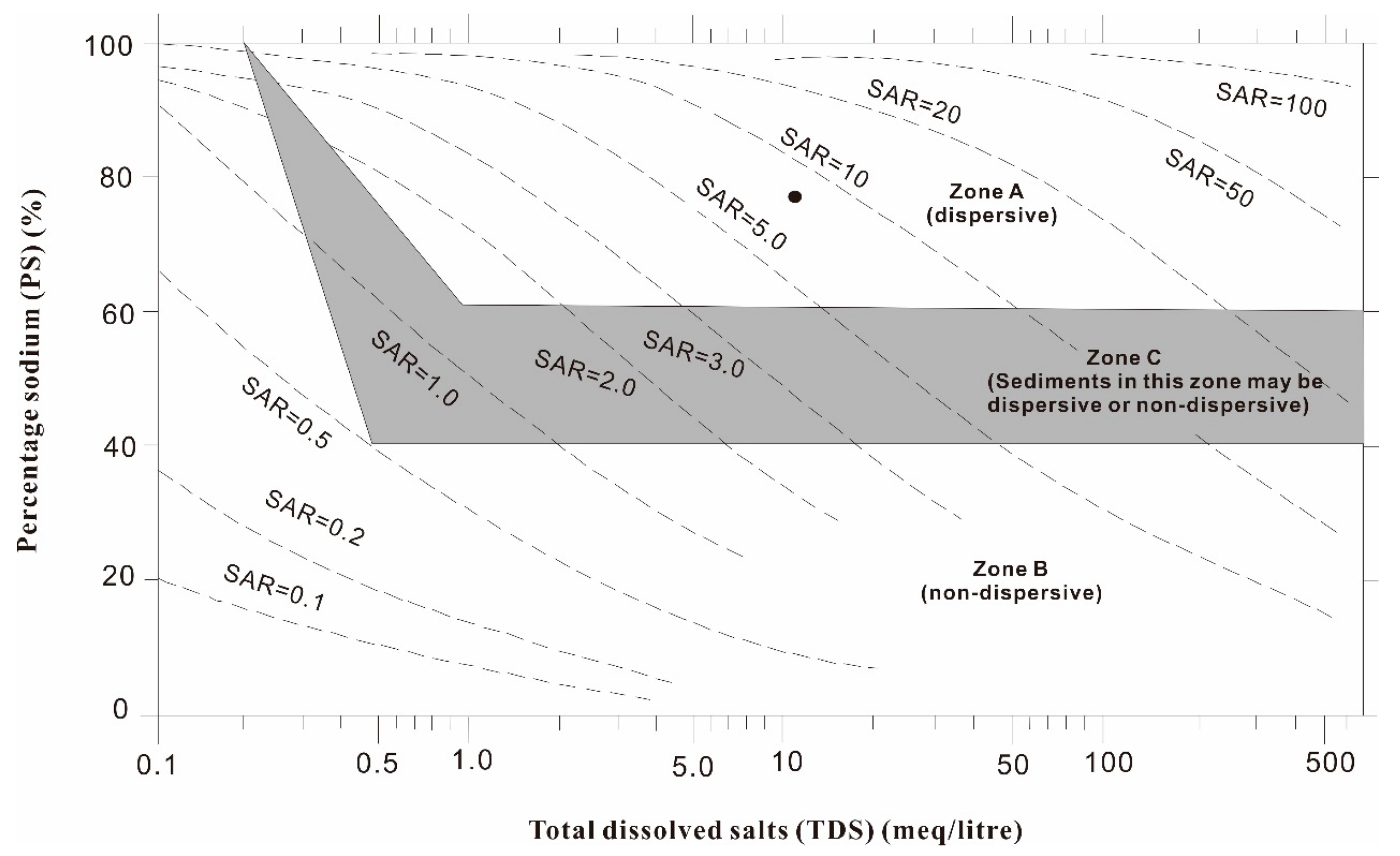
3.2.3. Soil Physicochemical Properties

Certain physicochemical properties of the clays were found to influence the different erosion processes fundamentally [52]. The textural data in Table 2 and Figure 10 demonstrate that all samples are sandy–clayey silt with a high sandy fraction. Grain size analysis shows that (a) no particles are larger than 0.5 mm, (b) approximately 70% of particles are smaller than 0.075 mm, and (c) a clay fraction <0.005 mm represents that all samples are approximately 25%. Soil particles are dominated by silt with weak hydrophilic, which is easy to erode by precipitation and groundwater during the rainy season. The data in Table 3 demonstrate that all samples have a high porosity greater than 50%. These pores provide channels for rainfall infiltration and migration of fine particles, accompanied by the process of physical sub-erosion [53]. The higher porosity accelerates the sub-erosion process. Fine particles migrate through pores to the free face along with water. The soil cave piping failure of the slope is accelerated. Table 3 shows several physical soil properties, including the important soil plasticity index. The plasticity index of the soil samples is small; thus, the plasticity of the soil sample is poor and easily suffers irreparable damage when exposed to external forces. Furthermore, the liquid indices of the soil samples are less than 0, indicating that the soil samples have no plasticity [54].
Table 4 and Table 5 show the mineralogical and chemical compositions of the samples, respectively. The mineral composition of sediments is relatively uniform; quartz, potash feldspar, plagioclase, and calcite are the main non-clay components, and dolomite components are only present in the C8 sample. The clay mineral assemblage is characterized by a mass of illite/smectite mixed layer, minerals, with a small number of chlorites. Illite/smectite mixed layer minerals have a weak connection, it is easy for the water molecule to infiltrate, and the shear strength is low. The shear strength of soil decreases after water absorption, which is a reason for soil slope failure. The mixed layer minerals not only have a strong hydrophilicity, but also have the property of expansion and contraction. Its cementation and adhesion often change reversibly with the change of water content. That is to say, the cementation is strong in the dry climate, and weak in the precipitation infiltration condition [23]. Therefore, after rainfall infiltration, soil cementation strength decreases. Further, soil shear strength decreases. The soil cannot bear the shear stress of the sidewall soil and vertical collapse occurs. The chemical composition of the studied samples (Table 5) is uniform and closely reflects their mineralogy. The chemical compositions of SiO2, Al2O3, and CaO are the highest, which is consistent with the main mineral compositions of quartz and feldspar.
Monovalent cations, particularly sodium and lithium, promote dispersion, whereas di- and trivalent cations favor flocculation [55]. Table 6 shows the content of monovalent cation (Na+ and K+) evidently is higher than that of divalent cation (Mg2+ and Ca2+). The diffusion layer formed by sodium ions is relatively thick, and the high content of sodium ions reduces the cohesion of soil particles, which is conducive to their dispersion. An alkaline environment for soil dispersion was provided because the PH is 8.2 (Table 6), which provides an environment for the occurrence of chemical sub-erosion.
Clay dispersibility is a good indicator of the dispersion vulnerability of soil and, therefore, of the associated risks of soil erosion [56]. Sherard et al. [57] regarded SAR, TDS, and PS as the dispersion functions and discussed the relationship (Figure 11). They showed that the clays of zone A have a high tendency for spontaneous dispersion, the materials of zone B are ordinary erosion-resistant clays, and the sediments of zone C may be dispersive or nondispersive. Table 6 presents the results of SAR, TDS, and PS. The sample plots fall under zone A (Figure 11), which indicates its high dispersivity. Clay dispersibility results in the disruption of soil stability and fragmentation [58,59,60,61] and increased soil water erosion [59,62]. Furthermore, Sherard et al. [57] pointed out that dispersive clays most often develop large pipes and erosion tunnels through rapid enlargement of small cracks and fissures as a consequence of the spontaneous dispersion of clays lining the fissure walls when these come in contact with rainwater. Thus, the parent materials of the mud forest area have a great propensity to produce a colloidal dispersion when saturated by rainwater. The dispersion of cementing material destroys the cementation of soil, thus the particle size of soil decreases. Fine particles are easier to be carried away by rainfall and groundwater. Found in concave terrains, due to the migration of fine particles, the internal pore volume of soil increases then gravity erosion occurs. Under the action of gravity, the overlying soil collapses, forming caves. Regarding the vertical slope, fine particles are easy to be carried due to the strong dispersion of soil, which leads to the decline in the cementation strength of soil. This promotes the occurrence of vertical collapse.
Underground water composition plays a vital role in landform development. The relative amounts of monovalent and di- or trivalent cations in the underground water (and then in the adsorbed complex) significantly influence the clay’s physical properties, in particular, their tendency for spontaneous colloidal dispersion (dispersivity) [47]. Table 7 shows that the water sample is white and turbid, indicating the dispersion of soil substances. Sodium ion, bicarbonate ion, and chloride ion contents in the water sample are very high, forming a hydrochemical type of HCO3·Cl-Na. This finding is consistent with the results of soluble salts in soil.
When the soil is dry in its natural condition, cemented connection and strong adsorbed water connection is the dominant position. However, this type of connection has weak water resistance, especially in high Na ion content, and thick water film forms when waters meet. Thus, the soil particles are extremely easy to disperse.

4. Conclusions

Land degradation in the mud forest area threatens the lives and property of hundreds of people and numerous farmlands. A comprehensive knowledge of the cause–effect relationship between sub-erosion and soil slope failure is the basis for finding methods of curbing land degradation. This condition is primary for preserving degraded landscapes. Two typical types of slope failure: soil cave piping failure and vertical collapse of slope, were found. Sub-erosion caused by surface water infiltration is highly important for slope failure. Soil in the study area was loose and porous. Due to the high soluble salt content, chemical sub-erosion played a significant role. Once the cementing material was destroyed, fine particles were transported along the rich pore and accompanied by the process of physical sub-erosion. Therefore, this area is the result of the combined effect of physical and chemical sub-erosion. The cause of soil slope failure is closely related to geological structure, topographic conditions, soil physicochemical properties, and climatic conditions. Among these influencing conditions, geological and topographic factors are the root, and climatic conditions are the external factors. The special property of the loess sub-sandy soil with high silt component and high soluble salt is easy to disperse, which is the fundamental factor for slope failure. Soil particles and water solutions rich in sodium ions form an ionic diffusion layer, and the high content of sodium ions thickens the water film of the diffusion layer and reduces the intergranular attraction, which is the essential factor of soil slope failure. Accelerative factors for soil cave piping failure are: (1) Concave relief; (2) Concentrated precipitation; (3) Developmental pores in the soil; and (4) Dispersed soil. Accelerative factors for vertical collapse of slope are: (1) Near-vertical slope morphology; (2) Developmental vertical cracks; (3) Precipitation and dry–wet circulation; (4) Rich illite/smectite mixed layer minerals; and (5) Dispersed soil.

Author Contributions

Data curation, X.R. and L.N.; Formal analysis, H.W.; Funding acquisition, Y.X.; Investigation, X.R.; Methodology, X.R. and L.N.; Writing—original draft, X.R.; Writing—review & editing, Y.X.

Funding

This research received financial support from the Natural Science Foundation of China (grant no.41702300), (grant no.41502270), and (grant no. 41572254).

Acknowledgments

The authors are grateful for financial support from the Natural Science Foundation of China (grant no.41702300), (grant no.41502270), and (grant no. 41572254). And we received funds to cover publication costs. We wish to thank the testing science experiment center of Jilin University for supporting experiment. We would also like to thank the Jilin Dabusu National Nature Reserve Administration for supporting our research work.

Conflicts of Interest

The authors declare no conflict of interest.

References

  1. Zhou, B.-B.; Wu, J.; Anderies, J.M. Sustainable landscapes and landscape sustainability: A tale of two concepts. Landsc. Urban Plan. 2019, 189, 274–284. [Google Scholar] [CrossRef]
  2. García-Quintana, A.; García-Hidalgo, J.F.; Martin-Duque, J.F.; Pedraza, J.; González-Martin, J.A. Geological factors of the Guadalajara landscapes (Central Spain) and their relevance to landscape studies. Landsc. Urban Plan. 2004, 69, 417–435. [Google Scholar] [CrossRef] [Green Version]
  3. González, A.; Fry, J. Developing Integrated Biodiersity Impact Assessment (IBIA): Data limitations on GIS Support. In Proceedings of the IAIA11 Conference Proceedings, Puebla, Mexico, 28 May–4 June 2011; pp. 1–7. [Google Scholar]
  4. Marchi, M.; Ferrara, C.; Biasi, R.; Salvia, R.; Salvati, L. Agro-Forest Management and Soil Degradation in Mediterranean Environments: Towards a Strategy for Sustainable Land Use in Vineyard and Olive Cropland. Sustainability 2018, 10, 2565. [Google Scholar] [CrossRef]
  5. Potschin, M.B.; Haines-Young, R.H. Landscapes and sustainability. Landsc. Urban Plan. 2006, 75, 155–161. [Google Scholar] [CrossRef]
  6. Wieland, R.; Lakes, T.; Yunfeng, H.; Nendel, C. Identifying drivers of land degradation in Xilingol, China, between 1975 and 2015. Land Use Policy 2019, 83, 543–559. [Google Scholar]
  7. Vlami, V.; Zogaris, S.; Djuma, H.; Kokkoris, I.; Kehayias, G.; Dimopoulos, P. A Field Method for Landscape Conservation Surveying: The Landscape Assessment Protocol (LAP). Sustainability 2019, 11. [Google Scholar] [CrossRef]
  8. Jakab, G.; Madarász, B.; Szabó, J.; Tóth, A.; Zacháry, D.; Szalai, Z.; Kertész, Á.; Dyson, J. Infiltration and Soil Loss Changes during the Growing Season under Ploughing and Conservation Tillage. Sustainability 2017, 9, 1726. [Google Scholar] [CrossRef]
  9. Gomiero, T. Soil Degradation, Land Scarcity and Food Security: Reviewing a Complex Challenge. Sustainability 2016, 8, 281. [Google Scholar] [CrossRef]
  10. Lal, R. Soil degradation by erosion. Land Degrad. Dev. 2001, 12, 519–539. [Google Scholar] [CrossRef]
  11. Chalise, D.; Kumar, L.; Kristiansen, P. Land Degradation by Soil Erosion in Nepal: A Review. Soil Syst. 2019, 3, 12. [Google Scholar] [CrossRef]
  12. Turner, K.G.; Anderson, S.; Gonzales-Chang, M.; Costanza, R.; Courville, S.; Dalgaard, T.; Dominati, E.; Kubiszewski, I.; Ogilvy, S.; Porfirio, L.; et al. A review of methods, data, and models to assess changes in the value of ecosystem services from land degradation and restoration. Ecol. Model. 2016, 319, 190–207. [Google Scholar] [CrossRef]
  13. Pimentel, D. Soil Erosion: A Food and Environmental Threat. Environ. Dev. Sustain. 2006, 8, 119–137. [Google Scholar] [CrossRef]
  14. Bernatek-Jakiel, A.; Poesen, J. Subsurface erosion by soil piping: Significance and research needs. Earth-Sci. Rev. 2018, 185, 1107–1128. [Google Scholar] [CrossRef]
  15. Smetanova, A.; Follain, S.; David, M.; Ciampalini, R.; Raclot, D.; Crabit, A.; Le Bissonnais, Y. Landscaping compromises for land degradation neutrality: The case of soil erosion in a Mediterranean agricultural landscape. J. Environ. Manag. 2019, 235, 282–292. [Google Scholar] [CrossRef] [PubMed]
  16. Ebabu, K.; Tsunekawa, A.; Haregeweyn, N.; Adgo, E.; Meshesha, D.T.; Aklog, D.; Masunaga, T.; Tsubo, M.; Sultan, D.; Fenta, A.A.; et al. Effects of land use and sustainable land management practices on runoff and soil loss in the Upper Blue Nile basin, Ethiopia. Sci. Total Environ. 2019, 648, 1462–1475. [Google Scholar] [CrossRef] [PubMed]
  17. Panagos, P.; Borrelli, P.; Poesen, J.; Ballabio, C.; Lugato, E.; Meusburger, K.; Montanarella, L.; Alewell, C. The new assessment of soil loss by water erosion in Europe. Environ. Sci. Policy 2015, 54, 438–447. [Google Scholar] [CrossRef]
  18. Nyamekye, C.; Thiel, M.; Schönbrodt-Stitt, S.; Zoungrana, B.; Amekudzi, L. Soil and Water Conservation in Burkina Faso, West Africa. Sustainability 2018, 10, 3182. [Google Scholar] [CrossRef]
  19. Xin, Y.; Liu, G.; Xie, Y.; Gao, Y.; Liu, B.; Shen, B. Effects of soil conservation practices on soil losses from slope farmland in northeastern China using runoff plot data. Catena 2019, 174, 417–424. [Google Scholar] [CrossRef]
  20. Sterpi, D. Effects of the Erosion and Transport of Fine Particles due to Seepage Flow. Int. J. Geomech. 2003, 3, 111–122. [Google Scholar] [CrossRef]
  21. Kong, W.; Yao, Y.; Zhao, Z.; Qin, X.; Zhu, H.; Wei, X.; Shao, M.; Wang, Z.; Bao, K.; Su, M. Effects of vegetation and slope aspect on soil nitrogen mineralization during the growing season in sloping lands of the Loess Plateau. Catena 2019, 172, 753–763. [Google Scholar] [CrossRef]
  22. Zhuang, J.Q.; Peng, J.B. A coupled slope cutting—A prolonged rainfall-induced loess landslide: A 17 October 2011 case study. Bull. Eng. Geol. Environ. 2014, 73, 997–1011. [Google Scholar] [CrossRef]
  23. Conforti, M.; Pascale, S.; Sdao, F. Mass movements inventory map of the Rubbio stream catchment (Basilicata—South Italy). J. Maps 2014, 11, 454–463. [Google Scholar] [CrossRef]
  24. Xu, X.Z.; Guo, W.Z.; Liu, Y.K.; Ma, J.Z.; Wang, W.L.; Zhang, H.W.; Gao, H. Landslides on the Loess Plateau of China: A latest statistics together with a close look. Nat. Hazards 2017, 86, 1393–1403. [Google Scholar] [CrossRef]
  25. Dai, F.C.; Lee, C.F. Landslide characteristics and slope instability modeling using GIS, Lantau Island, Hong Kong. Geomorphology 2002, 42, 213–228. [Google Scholar] [CrossRef]
  26. Wang, J.J.; Liang, Y.; Hui, P.Z.; Wu, Y.; Lin, X. A loess landslide induced by excavation and rainfall. Landslides 2014, 11, 141–152. [Google Scholar] [CrossRef]
  27. Hu, X.S.; Brierley, G.; Zhu, H.L.; Li, G.R.; Fu, J.T.; Mao, X.Q.; Yu, Q.Q.; Qiao, N. An exploratory analysis of vegetation strategies to reduce shallow landslide activity on loess hillslopes, Northeast Qinghai-Tibet Plateau, China. J. Mt. Sci. 2013, 10, 668–686. [Google Scholar] [CrossRef] [Green Version]
  28. Guo, W.Z.; Luo, L.; Wang, W.L.; Liu, Z.Y.; Chen, Z.X.; Kang, H.L.; Yang, B. Sensitivity of rainstorm-triggered shallow mass movements on gully slopes to topographical factors on the Chinese Loess Plateau. Geomorphology 2019, 337, 69–78. [Google Scholar] [CrossRef]
  29. Varnes, D.J. Slope Movement Types and Processes; Landslide Analysis and Control. Transportation Research Board Special Report; National Academy of Sciences: Washington, DC, USA, 1978; pp. 11–33. [Google Scholar]
  30. Guerra, A.J.T.; Fullen, M.A.; Jorge, M.D.C.O.; Bezerra, J.F.R.; Shokr, M.S. Slope Processes, Mass Movement and Soil Erosion: A Review. Pedosphere 2017, 27, 27–41. [Google Scholar] [CrossRef]
  31. Derbyshire, E. Geological hazards in loess terrain, with particular reference to the loess regions of China. Earth-Sci. Rev. 2001, 54, 231–260. [Google Scholar] [CrossRef]
  32. Xu, L.; Dai, F.; Tu, X.; Tham, L.G.; Zhou, Y.; Iqbal, J. Landslides in a loess platform, North-West China. Landslides 2013, 11, 993–1005. [Google Scholar] [CrossRef]
  33. Abramson, L.; Lee, T.; Sharma, S. Slope Stability and Stabilization Methods; John Wiley & Sons: New York, NY, USA, 2002. [Google Scholar]
  34. Li, X.A.; Peng, J.B.; Ma, R.R.; Qiao, X.Y.; Kang, J.H.; Li, L. On the hazards and evolution processes of loess tunnels. J. Xi’an Univ. Sci. Technol. 2009, 29, 737–741. [Google Scholar]
  35. Li, X.A.; Song, Y.X.; Ye, W.J. Engineering Geological Research on Tunnel-Ersion in Loess; TONGJI UNIVERSITY PRESS: Shanghai, China, 2010; p. 151. (In Chinese) [Google Scholar]
  36. Zhou, X.C.; Wang, C.; Ren, G.; Cai, W.D.; Zhang, B.F. The genetic characteristics of the Dabusu mud forest, and its protection and development suggestions. Jilin Geol. 2003, 22, 62–67. (In Chinese) [Google Scholar]
  37. Chi, Y.; Wang, Q.; Yang, J. Formation of Qian’an “Mud Forest” in Jilin Province. J. Eng. Geol. 2006, 14, 174–178. (In Chinese) [Google Scholar]
  38. Zhu, Q.G.; Liang, X.J. A preliminary syudy on the origin of the “Wolf’s fang shaped” topography on the eastern bank of the Dabusu lake. Jilin Geol. 1991, 1, 75–78. [Google Scholar]
  39. The Jilin Dabusu National Nature Reserve Administration. 2013–2014 Project Design Report of Jilin Qian-an Mud Forest Geological Relics and Vertebrate Fossil Site Protection. (unpublished).
  40. Yang, L.; Shi, K.Q.; Zhang, B.B. Temporal and spatial distribution characteristics of evaporation volume in Jilin province in recent 40 years. In Proceedings of the 35th Annual Meeting of the Chinese Meteorological Society S6 on Climate Change, Low-Carbon Development and Ecological Civilization Construction, Hefei, China, 24–26 October 2018. [Google Scholar]
  41. Jackson, M.L. Soil Chemical Analysis; Prentice-Hall: Upper Saddle River, NJ, USA, 1958. [Google Scholar]
  42. Franzini, M.; Leoni, L.; Saitta, M. A simple method to evaluate the matrix effects in X-Ray fluorescence analysis. X-Ray Spectrom. 1972, 1, 151–154. [Google Scholar] [CrossRef]
  43. Leoni, L.; Saitta, M. X-ray fluorescence analysis of 29 trace elements in rock and mineral standards. Rend. Soc. Ital. Mineral. Petrol. 1976, 32, 497–510. [Google Scholar]
  44. Tertian, R. Principles of Quantitative X-Ray Fluorescence Analysis; Heyden: Rhone-Poulenc Industries: Aubervilliers, France, 1982. [Google Scholar]
  45. Wobrauschek, P. Total reflection x-ray fluorescence analysis—A review. X-Ray Spectrom. 2007, 36, 289–300. [Google Scholar] [CrossRef]
  46. Battagliaa, S.; Leonib, L.; Sartorib, F. Mineralogical and grain size composition of clays developing calanchi and biancane erosional landforms. Geomorphology 2003, 49, 153–170. [Google Scholar] [CrossRef]
  47. Chen, A.; Zhang, D.; Yan, B.; Lei, B.; Liu, G. Main types of soil mass failure and characteristics of their impact factors in the Yuanmou Valley, China. Catena 2015, 125, 82–90. [Google Scholar] [CrossRef]
  48. Jeong, S.; Lee, K.; Kim, J.; Kim, Y. Analysis of Rainfall-Induced Landslide on Unsaturated Soil Slopes. Sustainability 2017, 9, 1280. [Google Scholar] [CrossRef]
  49. Gonzalez-Hidalgo, J.C.; Batalla, R.J.; Cerda, A.; de Luis, M. A regional analysis of the effects of largest events on soil erosion. Catena 2012, 95, 85–90. [Google Scholar] [CrossRef]
  50. Wang, L.-L.; Tang, C.-S.; Shi, B.; Cui, Y.-J.; Zhang, G.-Q.; Hilary, I. Nucleation and propagation mechanisms of soil desiccation cracks. Eng. Geol. 2018, 238, 27–35. [Google Scholar] [CrossRef]
  51. Precipitation in Songyuan City, Jilin Province, China. Available online: http://weather.sina.com.cn/qianan. (accessed on 8 March 2019).
  52. Piccarreta, M.; Faulkner, H.; Bentivenga, M.; Capolongo, D. The influence of physico-chemical material properties on erosion processes in the badlands of Basilicata, Southern Italy. Geomorphology 2006, 81, 235–251. [Google Scholar] [CrossRef]
  53. Sun, J.Z. Loessology; HONG KONG ARCHAEOLOGICAL SOCIETY: Hong Kong, China, 2005; Volume 1, pp. 40–43. [Google Scholar]
  54. Tang, D.X.; Liu, Y.R.; Zhang, W.S.; Wang, Q. Engineering Geotechnical; Geological Publishing House: BeiJing, China, 1998; Volume 2, pp. 61–68. [Google Scholar]
  55. Mitchell, J.K. Fundamentals of Soil Behavior; Wiley: New York, NY, USA, 1976; p. 422. [Google Scholar]
  56. Lipiec, J.; Czyż, E.A.; Dexter, A.R.; Siczek, A. Effects of soil deformation on clay dispersion in loess soil. Soil Tillage Res. 2018, 184, 203–206. [Google Scholar] [CrossRef]
  57. Sherard, J.L.; Dunnigan, L.P.; Decker, R.S. Identification and nature of dispersive soils. ASCE J. Geotech. Eng. Div. 1976, 102, 287–301. [Google Scholar]
  58. Abdollahi, L.; Schjønning, P.; Elmholt, S.; Munkholm, L.J. The effects of organic matter application and intensive tillage and traffic on soil structure formation and stability. Soil Tillage Res. 2014, 136, 28–37. [Google Scholar] [CrossRef]
  59. Turgut, A.; Isik, N.S.; Kasapoglu, K.E. Investigation of factors affecting the dispersibility of clays and estimation of dispersivity. Bull. Eng. Geol. Environ. 2016, 76, 1051–1073. [Google Scholar] [CrossRef]
  60. Farahani, E.; Emami, H.; Keller, T.; Fotovat, A.; Khorassani, R. Impact of monovalent cations on soil structure. Part I. Results of an Iranian soil. Int. Agrophysics 2018, 32, 57–67. [Google Scholar] [CrossRef]
  61. Farahani, E.; Emami, H.; Keller, T. Impact of monovalent cations on soil structure. Part II. Results of two Swiss soils. Int. Agrophysics 2018, 32, 69–80. [Google Scholar] [CrossRef] [Green Version]
  62. Kjaergaard, C.; de Jonge, L.W.; Moldrup, P.; Schjønning, P. Water-dispersible colloids: Effects of measurement method, clay content, initial soil matric potential, and wetting rate. Vadose Zone J. 2004, 3, 403–412. [Google Scholar] [CrossRef]
Figure 1. Mud forest sub-erosion landscape.
Sustainability 11 04709 g001
Figure 2. Soil slope failure threatens large areas of farmland.
Sustainability 11 04709 g002
Figure 3. Location of the study area.
Sustainability 11 04709 g003
Figure 4. The Dabusu National Nature Reserve geomorphological map [39].
Sustainability 11 04709 g004
Figure 5. Drill column near the sampling location.
Sustainability 11 04709 g005
Figure 6. Moniliform sinkhole and soil bridge. Moniliform sinkholes can be seen in the (a,b), and soil bridges can be seen in the (c).
Sustainability 11 04709 g006
Figure 7. Vertical collapse failure.
Sustainability 11 04709 g007
Figure 8. Horizontal suffosion caves or channels formed at the foot of the slope.
Sustainability 11 04709 g008
Figure 9. Formation process of vertical slope failure in the mud forest area. (a) Surface water infiltrates along the vertical joints; (b) vertical cracks are wide and deep, with vertical layered or columnar soil formed by cutting, and a hollowed zone forms at the bottom of layered or columnar soil by horizontal seepage; (c) staggered slope begins to occur; (d) vertical collapse of slope occurs.
Sustainability 11 04709 g009
Figure 10. Grain size composition of the plot samples on the ternary diagram.
Sustainability 11 04709 g010
Figure 11. Sherard’s suggested diagnosis shows that the sample has a dispersivity (expressed through the PS, TDS, and SAR parameters defined in Table 3) [57].
Sustainability 11 04709 g011
Table 1. Total annual average precipitation and evaporation in Songyuan, Jilin province. The data include the average data of precipitation and evaporation from 2014–2018 [51].
Month123456789101112Total
Precipitation (mm)1.191.705.9315.6825.7863.59136.1994.2537.6014.595.162.35404.05
Evaporation (mm)18.832.591.1233.9344.0287.9242.1198.8162.2125.051.322.11798.5
Table 2. Grain size composition.
SampleDepth (m)Grain Size Composition (wt. %)
>2 mm(2–1) mm(1–0.5) mm(0.5–0.25) mm(0.25–0.075) mm(0.075–0.005) mm<0.005 mm
C11---0.8723.8051.3523.98
C23---0.4425.0047.9526.60
C35---0.6328.5741.8928.92
C47---1.7724.6046.6626.97
C59---1.1724.2052.5322.10
C611---0.1230.2345.6823.97
C713---0.6828.4648.1422.72
C815---1.7329.8340.4527.98
Table 3. Physical properties of soil.
SampleDensity (g/cm3)Moisture Content (%)Plastic Limit (%)Liquid Limit (%)Plastic IndexLiquidity IndexPorosity
C11.231020.1924.714.52−3.4755.65
C21.3010.1519.4622.192.73−2.2557.60
C31.5915.7118.8024.876.07−0.5158.38
C41.3515.7118.3026.177.87−0.3353.21
C51.3616.7317.9028.6710.77−0.1154.47
C61.5117.2218.9024.805.90−0.2850.48
C71.3316.6520.9124.844.61−1.8456.69
C81.2616.6520.9124.843.93−1.0856.43
Table 4. Mineral composition of soil.
SampleQzPhfPeCcDolChlIsm
C13026109-223
C2282979--27
C3322666--30
C4302688--28
C5342299--26
C6303387--22
C7392688--19
C83828954-16
Note: Qz = quartz; Phf = potash feldspar; Pe = plagioclase; Cc = calcite; Dol = dolomite; Chl = chlorite; Ism = illite/smectite mixed layer minerals.
Table 5. Chemical composition of soil (major element, in wt. %).
SiO2Al2O3Fe2O3FeOCaOMgOK2ONa2OTiO2P2O5MnOLOI
C173.739.701.860.363.630.892.781.570.360.050.074.60
C270.2511.361.880.233.850.952.661.990.440.050.075.77
C368.8012.962.010.453.971.122.811.670.390.060.075.34
C471.2311.952.660.474.041.082.951.860.550.070.083.01
C569.5410.882.360.394.341.052.882.110.480.060.095.78
C665.6012.562.890.545.271.362.872.010.570.070.096.16
C767.7812.892.560.494.221.212.772.210.570.070.075.14
C868.4812.022.480.494.291.162.962.240.580.070.074.74
Table 6. Soluble salt content (meq/l) and related parameters controlling clay dispersivity.
Na+K+Ca2+Mg2+SO2–4ClHCO-3TDS aPS bSAR cPH
Content7.8440.0141.8960.3011.6234.0114.86510.05578.0117.4848.2
a TDS = total dissolved salts = Na+ + K+ + Ca2+ + Mg2+ (in meq/L); b PS = percentage sodium = [Na+ (meq/L)/TDS (meq/L)] × 100; c SAR = sodium adsorption ratio = Na+ (meq/L)/[(Ca2+ + Mg2+)/2]1/2.
Table 7. Results of water sample analysis (mg/L).
Test ItemValueTest ItemValueTest ItemValueTest ItemValue
Visible substancesWhite and turbidZn2+0.002SO42−99.1NO2(N)0.003
Water temperature15Cd+0.00082Cl589.9HCO3696.1
PH7.01Cr3+/Cr6+0.0001NO3(N)0.30Na+481.96
ORP127.1As3+/As5+0.0085Fe2+/Fe3+0.814K+0.707
MnO44.10Hg2+0.0049Mn2+/Mn4+0.0001Ni2+0.0047
NH3/NH4+0.148Ca2+272.1Cu2+0.0204Mg2+39.68
F-0.52Water hardness842.8Pb2+0.00087Total dissolved solids2184

