Sustainable Development Research on the Spatial Differences in the Elderly Suitability of Shanghai Urban Parks

1
School of Mathematics and Computer Science, Shangrao Normal University, Shangrao 334001, China
2
Research Center for China Administrative Division, East China Normal University, Shanghai 200241, China
3
School of Urban and Regional Science, East China Normal University, Shanghai 200241, China
*
Authors to whom correspondence should be addressed.
Sustainability 2019, 11(22), 6521; https://0-doi-org.brum.beds.ac.uk/10.3390/su11226521
Submission received: 30 August 2019
/
Revised: 6 November 2019
/
Accepted: 15 November 2019
/
Published: 19 November 2019
(This article belongs to the Special Issue A Healthy Built Environment for an Ageing Population)
Abstract
:As an important subset of the urban population and a major contributor to urban social wealth, the elderly play an important role in a city’s sustainable development. Based on data from the statistical yearbook and an empirical investigation, this paper evaluated the elderly suitability of 75 parks in China’s Shanghai Central District using a self-defined Python script tool based on ArcGIS. According to spatial differences in the elderly suitability of parks, we employed spatial interpolation to explore the reasons for variations in park services in different residential spaces in Shanghai Central District. The results revealed the following: (1) the elderly suitability of parks in Shanghai Central District decreases gradually from the inner ring to the outer ring; (2) the park accessibility in Shanghai Central District is generally low, and the park service space can be divided into five categories ranging from “low accessibility, super-low elderly suitability” to “high accessibility, high elderly suitability”; and (3) the advantages of regional function and location, the development of regional culture and tourism economy, and the implementation of regional elderly-care policies are factors promoting the improvement of the elderly suitability of regional park services. Finally, this paper provided scientific decision-making suggestions for Shanghai and other aging cities to optimize the elderly suitability of urban parks.
1. Introduction
The elderly play a significant guiding role in both the current and future stages of a city’s sustainable development. They are an important subset of the urban population and a major contributor to urban social wealth [1]. Therefore, society benefits from ensuring that elderly individuals receive necessary assistance in all aspects of their lives. One way to realize these benefits is to ensure that urban public spaces and facilities are suitable for the elderly [2,3,4,5]. Providing safe, inclusive, and accessible public spaces can help the elderly obtain a higher quality of life and better health conditions [6,7]; thus, the sustainable development of cities can be more easily achieved [8].
In the 1960s, developed countries began to focus on the humanistic design of elderly residences. This trend was the origin of the elder-suitability concept. Initially, the concept referred to whether a certain residence’s internal spaces (or facilities) were suitable for the elderly to utilize or inhabit them. In the 1980s, however, Carstens [9] proposed that retirement communities should establish external spaces and facilities that were suitable for the elderly, thereby adapting to the varied abilities of this population. Marcus [10] also suggested that designs for elderly communities should combine gardening practices with health care to design therapeutic gardens. Such studies indicate that, with the rise in the aging population and the unique issues that accompany this group, scholars not only have focused on elderly residences but also increasingly considered the elderly suitability of urban outdoor spaces. These shifts aim to improve the quality of life of the elderly and to promote the sustainable development of urban society.
Compared to elderly suitability, the concept of a “sustainable city” was proposed in relatively recent years (1996). Since it is characterized by fairness, beauty, creation, ecology, and easy communication, the concept of a “sustainable city” has rapidly become more prevalent; some scholars even regard it as an ideal city model to facilitate the achievement of sustainable development goals [11]. The ultimate goal of sustainable urban development is to enhance the living environment and to improve the quality of life for all urban people, including the elderly [8]. Zhang Wenfan, the deputy director of the China Aged Work Committee Office, believes that “the sustainable development strategy is not only the premise and condition for realizing a healthy and aging society but also the only way for us to solve the problem of the elderly and to realize the sustainable development of human society” [12]. Thus, to establish a healthy aging society, it is not only feasible but also quite necessary to research how cities adapt to aging in terms of sustainable development.
Urban parks are the most visited public green spaces for the urban elderly and play an indispensable role in maintaining elderly physical and mental health and in fostering their daily social interactions. This has been shown in many studies on the elderly suitability of urban parks in recent years. Kemperman [13] and Levy-Storms [14] believe that the elderly need specific open spaces and moderately strenuous sports in or near parks. Gibson [15] contends that a natural environment in a park is an important prerequisite for the elderly to meet their autonomous needs and that, when these needs are met by a park, the elderly will want to visit again. Levinger [16] points out that urban public spaces should provide special outdoor sports equipment for the elderly while local authorities should consider how to provide safe access to the equipment. Zhai [17,18] demonstrated that the elderly prefer parks which have soft or even flat footpaths, along which there are benches, flowers, and light. Xie [19] showed that accessibility is the key factor affecting the elderly’s assessment of the potential usability of the parks. Finally, Zhai [20] found that, as long as the destination is attractive, 23.4% of elderly people would visit high-quality parks that are far away from home. All of these studies also indicate that the elderly have stricter requirements and needs in terms of usability [19], accessibility [19], safety [16], comfort [15], and entertainment [20] in parks than younger people.
On the whole, much research has been conducted on how urban planners should design suitable parks for the diversified needs of the elderly based on their health conditions [13,14,15], behavioral abilities, and characteristics [7,13,14,15,16]. However, there is still no research on the spatial difference of the elderly suitability of parks in a single city or in certain kinds of cities. The impact that spatial difference in the elderly suitability of urban parks has on the city’s elderly life and sustainable development seems to have been neglected. In fact, if the parks in a certain area of the city are less suitable, the elderly in this area may have to choose a high-quality park far from home [20]; this will not only add to the city’s traffic but also greatly reduce the elderly’s quality of life in the city, hindering the sustainable development of the city’s society. Therefore, we should not only focus on the improvement of the elderly suitability of some parks but also abide by the principles of sustainable urban development, which include “commonality,” “coordination,” “fairness,” and “sustainability.” We must pay more attention to the difference in the elderly suitability of all urban parks as well as to the rationality and scientificity of their spatial distribution.
To fill the gap in research, this study examined 75 parks on 77 streets (or towns) in the Shanghai Central District. Based on the evaluation of the elderly suitability of these urban parks as well as on the characteristics and causes of their spatial differences, this research analyzed the impact of spatial differences of the elderly suitability of urban parks on the park service of local residents’ space. It aims to provide suggestions and to become a reference for scientific decision making for Shanghai and other aging cities in order to optimize the elderly suitability of urban parks and to better guarantee the sustainable development of the city’s society.
2. Related Literature
While there is no standardized definition of urban park, one international common recognition is that parks meet the daily leisure and entertainment needs of residents [21,22]. Van Herzele et al. found that most countries agree on the maximum distance between urban green space and residential areas (generally between 0.15 km and 0.5 km), but less consensus exists concerning the standard size of the park area [23].
Park accessibility not only can represent the cost (time, distance, cost, energy, etc.) of people going to park green space but also can effectively reveal the rationality and fairness of the spatial pattern of the urban park system [24,25,26,27,28]. As a group, the elderly are disadvantaged by their limited physical and mental health. Therefore, accessibility should be an important index in judging the elderly suitability of urban park green space [19]. According to some studies, there are three main aspects that affect park accessibility. First is attractiveness, such as atmosphere quality [29], culture and history, natural environment, area, and facilities. Second is the characteristics of different demand groups, including age and economic status. Third is constituted by physical barriers to parks, e.g., rivers and traffic congestion [30,31].
The main accessibility evaluation methods include the GIS (Geographic Information System)-based statistical index method [32], travel cost method (e.g., cost weighted distance method [33] and network analysis method [34]), opportunity accumulation method (e.g., floating catchment area method [35]), spatial interaction method (e.g., potential model method [36,37]), time geography method, and topology method based on matrix or spatial syntax [38,39]. Kwan believes that reasonable abstraction and simplified expression of geographical entities (such as parks) is the primary issue in evaluating park accessibility [40]. The representation of a park by its geometric center (or centroid) [41] or its boundary [42] may lead to an underestimation or overestimation of park accessibility. Some studies have also proposed that the actual entrance point of the park represents the park [34], but we believe that this method is too complex and will greatly reduce the efficiency of the evaluation.
The aforementioned literature [13,14,15,16,17,18,19] reflects not only the stricter requirements of the elderly for park green space than those of younger people but also the preferences of the elderly for specific attributes of urban parks (including spatial and nonspatial aspects). Similar to these studies, Jin [43] considered that functional requirements, microclimate environment, appropriate enclosure, and management policy were the key factors concerning the improvement of the elderly suitability of urban micro-space through the survey of urban micro-space (including 18 factors of location, landscape, and environment). Based on the physiological and psychological characteristics of the elderly, Deng [44] proposed that comfort, identifiability, safety, space variety, and communicativeness are the optional indicators for evaluating the elderly suitability of the urban public space. According to Chen [45] and Levinger [16], accessible facilities; a well-lit, suitable spatial scale; activity centers for the elderly and children; resting seats; toilets; and cover/shade (preferably waterproof coverage) are the characteristics of age-friendly parks.
Based on the geographical location of the research area, this paper selected parks (including comprehensive parks, community parks, special parks, strip parks, street greenbelt, etc.) that meet the definition of the “Classification Standard of Urban Greenbelt in China” (No. CJJ/T 85-2002) as research objects. The selected parks are relatively independent, open to the public, and recreation-oriented and include green land with comprehensive functions of ecology, environment, and disaster prevention. Their service radius ranges from 0.15 km to greater than 2 km, and the area is as small as 0.8 hm2.
3. Materials and Methods
3.1. Research Area
Shanghai, China’s largest economic center, is located in the eastern part of the country, bordering the Yangtze River in the north, the East China Sea in the east, Hangzhou Bay in the south, and Jiangsu and Zhejiang in the west; the Huangpu River runs through the city. Due to the large elderly population and the current aging situation, Shanghai has launched a pilot project to become an “old-age friendly city” in some urban areas since 2009 and gradually implemented the Guidelines for the Construction of Shanghai as an Old-age Friendly City (Trial Implementation) in 2013. According to the 2015–2018 editions of the Shanghai statistical yearbook, however, although the Shanghai Central District (which includes the seven administrative divisions of Yangpu, Hongkou, Jing’an, Putuo, Changning, Xuhui, and Huangpu) accounts for about 45% of Shanghai’s population aged 60 and above, its parks occupy only 14.5% of the city’s total green space (Table 1). This reveals that the demand for green space in elderly-accessible parks in Shanghai Central District still urgently needs to be addressed and that the number, quality of service, spatial distribution, and other aspects of parks may require further enhancements.
3.2. Research Data
Two types of data were used in this research. First, the geospatial vector layer data of park green spaces, road networks, streets (or towns), and rivers in the research area were considered. These data were mainly sourced from the Shanghai Urban Traffic Map compiled by the Shanghai Surveying and Mapping Institute in January 2016 and were obtained by scanning paper maps and by performing classified vectorizing by ArcGIS 10.4 (a series of GIS softwares produced by American Environmental Systems Research Institute). Second, the general attribute data of various ground elements, including the number of permanent residents on each street (or town) at the end of 2016 and the score data of the evaluation index of the elderly suitability of each park, was obtained. The population data came from the statistical tables of administrative divisions compiled by the Shanghai Statistical Bureau in 2016. The index score data were based on field surveys and public comments on each park in the public commentary network (http://www.dianping.com/); a comprehensive score was assigned according to the unified standard.
3.3. Research Methods
3.3.1. Surveys
On-site interviews and questionnaires were employed to obtain the index score of the elderly on the suitability of parks. These are subjective indexes, such as park service attraction and park walkway spaciousness (as shown in Table 2).
On-site interview is the most effective method for truly understanding the status of the elderly suitability of parks. Due to the wide geographical coverage of this study, 2–3 parks were selected in each administrative district and 2–4 elderly groups (generally composed of 4–10 people) were randomly selected in each park for interviews. A total of 50 on-site interviews were conducted. We arranged the interviews on each weekend in April, May, and October 2018. Interviews were conducted during several different times each day: 06:30–08:30, 08:30–10:30, 14:30–16:30, and 16:30–18:30. April, May, and October were chosen because the weather is the mildest for Shanghai (about 20 °C) and therefore is most suitable for the elderly’s various outdoor activities.
A questionnaire was followed after each on-site interview. The questionnaires were conducted by nonrandom sampling, which contains the subjects’ background information and their scores on the indexes of the elderly suitability of their parks. A total of 150 self-administered questionnaires (excluding the elderly interviewed above) were received. Each questionnaire subject was an individual over 60 years old.
3.3.2. Evaluation Index System
Based on the existing literature [39,43,44,45], this paper suggests that spatial accessibility, health and recreation, environmental comfort, and environmental safety are important manifestations of the elderly suitability of urban parks and comprise essential demands of sustainable cities, which can fundamentally determine the elderly suitability of urban parks. Therefore, this paper considers these four attributes as the first-level index for the evaluation of the elderly suitability of urban parks and chooses the corresponding second-level index according to the principles of systematicness, representativeness, and feasibility. After expert judgement and analysis using the analytic hierarchy process, the evaluation index system of the elderly suitability of urban parks was created, as shown in Table 2.
From Table 2, we can see that environmental comfort, health, and recreation had higher weights in the first-level indexes. This is in line with the elderly’s desire for physical and mental health and their need for a comfortable and beautiful outdoor leisure environment. Environmental safety index had the smallest weight, which indicates that, although the elderly have special requirements for park safety, it is not the main aspect of their requirements for the elderly suitability of the parks. In addition, among the weights of the secondary indicators, the three indicators of pleasant degree of green landscapes, completeness of entertainment facilities, and completeness of recreation tables or chairs ranked the highest, indicating that improving the quality or level of these three park indicators can greatly improve the elderly suitability of the parks.
3.3.3. Workflow of Evaluation and Analysis
According to Zhai’s research (which states that, as long as the destination is attractive, 23.4% of elderly people would visit high quality parks that are far away from home [20]) and in order to avoid underestimation of park accessibility [41], this paper designates the shortest traffic distance between the centroid of the residential area and the centroid of the park as the limiting variable, assuming that the elderly only enjoy services in parks with the limiting variable value less than or equal to 2 km. First, by using the ArcGIS Origin-Destination cost matrix analysis module, the Origin-Destination cost matrix between each park and all residential areas (with a maximum distance of 2 km) was obtained. Second, by using the self-defined Python script tools based on ArcPy (a Python site package based on ArcGIS scripting produced by American Environmental Systems Research Institute) and the improved potential model, the accessibility and the elderly suitability of parks were calculated successively. Finally, the general Kriging interpolation, based on ArcGIS, was used to obtain the elderly suitability of any location park services in the research area. Based on this procedure, the types of park service spaces in the research area were classified and the reasons for the formation of this spatial pattern of park service were also analyzed (Figure 1).
The ArcGIS Origin-Destination cost matrix analysis refers to a branch of the ArcGIS network analysis module. It not only can determine the minimum cost path from multiple source points to multiple destinations in the network but also can record the minimum network distance between each source point and the corresponding destination automatically in the “line” attribute data table and can allows us to specify the number of destinations and the maximum network distance to be searched as needed [46].
3.3.4. Elderly-Suitability Evaluation of Parks based on Self-Defined Scripting Tools
The potential model is derived from Hansen’s gravity model, which has been improved many times and is often used to measure spatial accessibility [47,48]. Because Equation (1) is a widely used improved potential model that can consider the attenuation of spatial effects of both suppliers and demanders with distance as well as the influence of the self-attraction of both suppliers and demanders [37], this paper uses it to solve park accessibility, which is the main influencing factor of the elderly suitability of parks.
where Ai refers to the spatial accessibility of residential area I to park green space j; Mj refers to the service attraction of park green space j; Vj refers to the negative impact of residential service demand (or residents’ competition for services) on the accessibility of park green space j; Dij refers to the actual distance from residential area I to park green space j; β refers to the travel friction coefficient; n and m are the number of park green spaces and residential areas, respectively; and Pk is the population of any residential area K around park green space J.
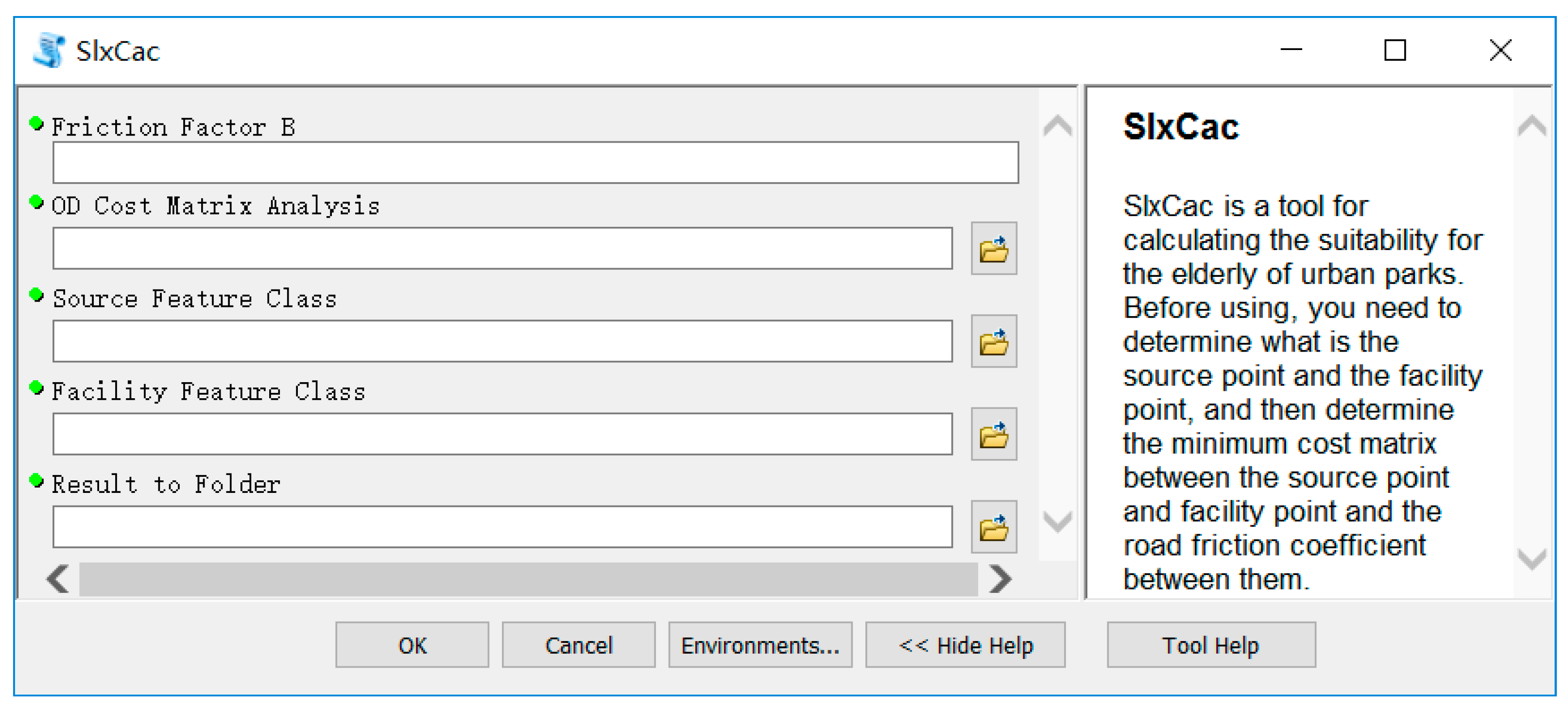
ArcPy can be used to practically and efficiently perform geographic data analysis, data conversion, data management, and map automation with Python [49]. In order to solve problems caused by large amounts of data (involving geospatial and general attribute data) and complex calculations as well as due to the fact that existing GIS software cannot directly evaluate the elderly suitability of urban parks, this paper customized a tool to evaluate the elderly suitability of parks by using Python script programming technology oriented to ArcGIS and based on the improved potential model and ArcPy [50]. Users can apply this tool to evaluate the elderly suitability of urban parks automatically and efficiently (Figure 2).
The specific process of developing this self-defined tool is as follows: (1) write Python program code with Python 3.7 (a Python program editor for Windows environment, https://www.python.org/getit/) and save it as a file suffixed with .py; (2) find the “My Toolbox” node in the Catalog of ArcMap (a member of the ArcGIS series software), and right click the node to create a new toolbox for storing the new tools; (3) right click on the new toolbox, and complete the following three tasks in the three dialog boxes using script addition Wizard:
- Set the name, label, description, and style sheet of this tool;
- Set up the function code file of this tool, which is the .py file created in step (1) above;
- Set the running parameters of this tool (including parameter display name, data type, default value and direction, etc.)
In this research, the Tool Style Sheet text box was set to empty, which allows us to use the same interface style as the tools in ArcToolBox. The main functional code (that is, the main content of the above .py file) for the tool can be found in Appendix A, and its execution can be completed within only 40 seconds.
3.3.5. Elderly-Suitability Estimation of Park Service in Residential Space Based on Spatial Interpolation
As the number and quality of parks accessible in adjacent residential areas are similar and related to each other, we believe that the suitability of the park services available to the neighboring elderly residents is similar and correlative. Therefore, to understand the impact of spatial differences in the elderly suitability of parks on local residential spaces’ park services, this paper presents the concept of “the elderly suitability of park service” and uses the method of spatial interpolation (a process of converting discrete point data into continuous data surfaces) to measure and discuss the elderly suitability of park service at various points in the research area.
Interpolation methods are numerous and vary in complexity and efficiency. Since the sample points of this study case are few [51] and ordinary kriging interpolation is defined as an optimal and unbiased linear estimation method based on spatial autocorrelation, which uses the structural properties of the semi-variogram and the data of the considered parameters to predict the value of a variable at non-sampled sites by a linear combination of point values of a regionalized variable or averages on blocks of a regionalized variable (Formula 2) [52,53], this paper chooses ordinary kriging interpolation to achieve the above purpose. The specific implementation steps are as follows. First, the sum of the elderly suitability of all accessible parks within 2 km of each street centroid was defined as the elderly suitability of park service at each street centroid. Second, taking the elderly suitability of park service at each street centroid as the known value, the elderly suitability of park service at any location in the research area was estimated by the ordinary kriging interpolation tool based on ArcGIS [54]. Finally, the spatial distribution map of the elderly suitability of park services in the research area was used to determine the impact of the spatial difference in the elderly suitability of the parks on local residential spaces’ park services.
where refers to the elderly suitability of park services at the estimated point ; refers to the true value of point , which is the elderly suitability of park service at each street’s centroid point; n refers to the number of known true points for interpolation (in this paper, 77 or the number of streets sampled); and refers to the kriging weight coefficient.
4. Results
4.1. Evaluation Results
Through the aforementioned method, this research evaluated the elderly suitability of the parks (Table 3) and its related indicators (including the spatial accessibility, healthy entertainment, environmental comfort, and environmental safety of parks) in Shanghai Central District. Descriptive statistics reveal that there are obvious differences in the elderly suitability of the parks in different administrative divisions of the central district. Among the administrative divisions, the average value in terms of elderly suitability, accessibility, healthy entertainment, environmental comfort, and environmental safety of parks for Huangpu District is higher than the overall average for the research area (0.58), followed by Changning and Yangpu. On the other hand, the average values of Xuhui and Putuo are lower.
4.2. Spatial Difference and Characteristic Analysis
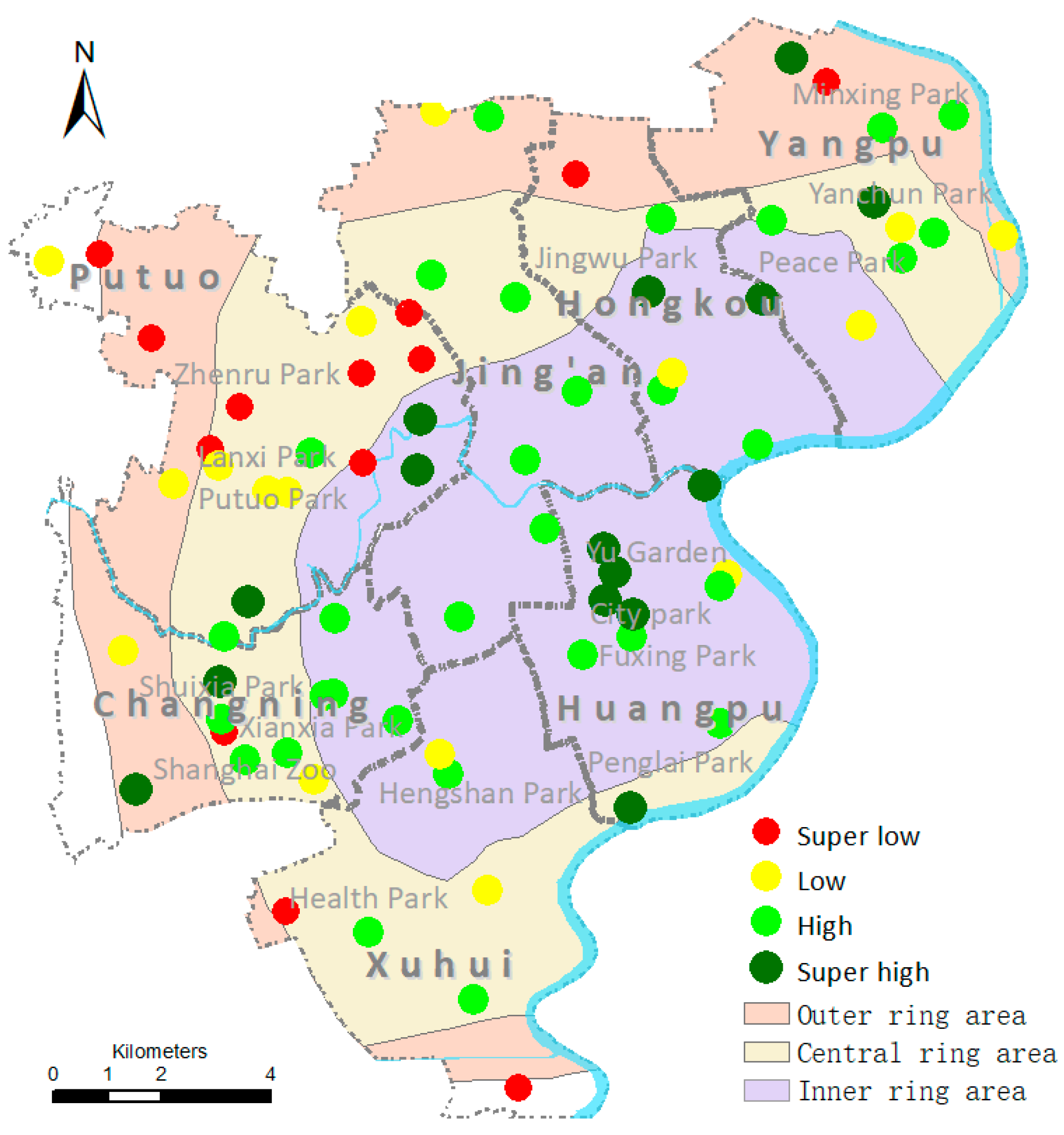
Based on the above results, by overlapping the layers of parks, administrative divisions, city ring lines, and elevated roads in ArcMap 10.4 and by using Jenks Natural Breaks to render the park elements according to the elderly-suitability value of parks with different symbols, a spatial distribution map of the elderly suitability of parks in the central district was created (Figure 3).
Figure 3 divides all parks in the Shanghai Central District into four levels according to their elderly-suitability value. The spatial distribution indicates that the elderly suitability of Shanghai urban parks tends to decrease gradually from the inner ring to the outer ring. This distribution also demonstrates the following trends: (1) most parks with super-high elderly suitability are located inside the inner ring and extend from southwest (Changning District) or southeast (Huangpu District) to northeast (Yangpu District); (2) most parks with high elderly suitability are also situated in the inner ring area, and the number of parks with high elder-suitability rapidly decrease in the central and outer rings; (3) the parks with low elderly suitability are mainly located in the central ring area, and these parks extend from the south (Xuhui District) or northeast (Yangpu District) parts of the central area to the central part of Putuo; and (4) the parks with super-low elderly suitability are mainly located in the central and the outer rings, but they stretch from the south (Xuhui South border) or northeast (Yangpu North border) parts of the Central Ring Line to the northwest (outer ring) area of Putuo.
At first glance, the local situation of each district appears unique; however, upon closer examination, several districts with higher levels of elderly suitability of parks (such as Huangpu, Changning, Yangpu, and Hongkou) have the characteristics of “high center” while several districts with lower levels of elderly suitability in parks (such as Xuhui, Putuo, etc.) have the characteristics of “low center.” Only Jing’an District has a balanced spatial distribution of the elderly suitability of parks.
This evidence indicates that the spatial distribution of the elderly suitability of parks in Shanghai Central District is different from the distribution generally found in the central district of small cities [55]. The elderly suitability of parks in the central area of small cities is generally characterized by a low center and high perimeter, but that is not true for Shanghai Central District. This difference may be related to its population, economic, and social development factors. First, due to differences in economic and cultural attributes of residents, the residents in the central area of the Shanghai metropolitan center might pay more attention to the quality requirements of parks than those in the central area of small prefecture-level city centers. Second, the suburbanization of residential areas in the Shanghai metropolis is obvious [56] and the elderly suitability of parks in the central area of the Shanghai metropolitan center is less affected by population factors; however, in small prefecture-level cities, the opposite is true. Moreover, the degree of population aging and the level of social and economic development present in small prefecture-level cities are obviously inferior to those of metropolitan cities. Thus, in the planning and management departments of small prefecture-level cities, attention to the elderly suitability of parks and actions to improve this are obviously lagging behind those of the metropolis [57]. Although both the Shanghai Central District and small prefecture-level city centers have performed similar promotion activities, the elderly suitability of parks in the central areas of the small prefecture-level city centers is still not as good as that of the beautiful, natural environment in the surrounding areas. Therefore, the spatial distribution of the elderly suitability of parks in small prefecture-level cities has the obvious characteristics of low center and high perimeter. However, the effects of initiatives to increase elderly suitability of parks in the central area of Shanghai Central District are so obvious that the elderly suitability of parks in the whole Central District decreases gradually from the inner ring to the outer ring.
5. Discussion
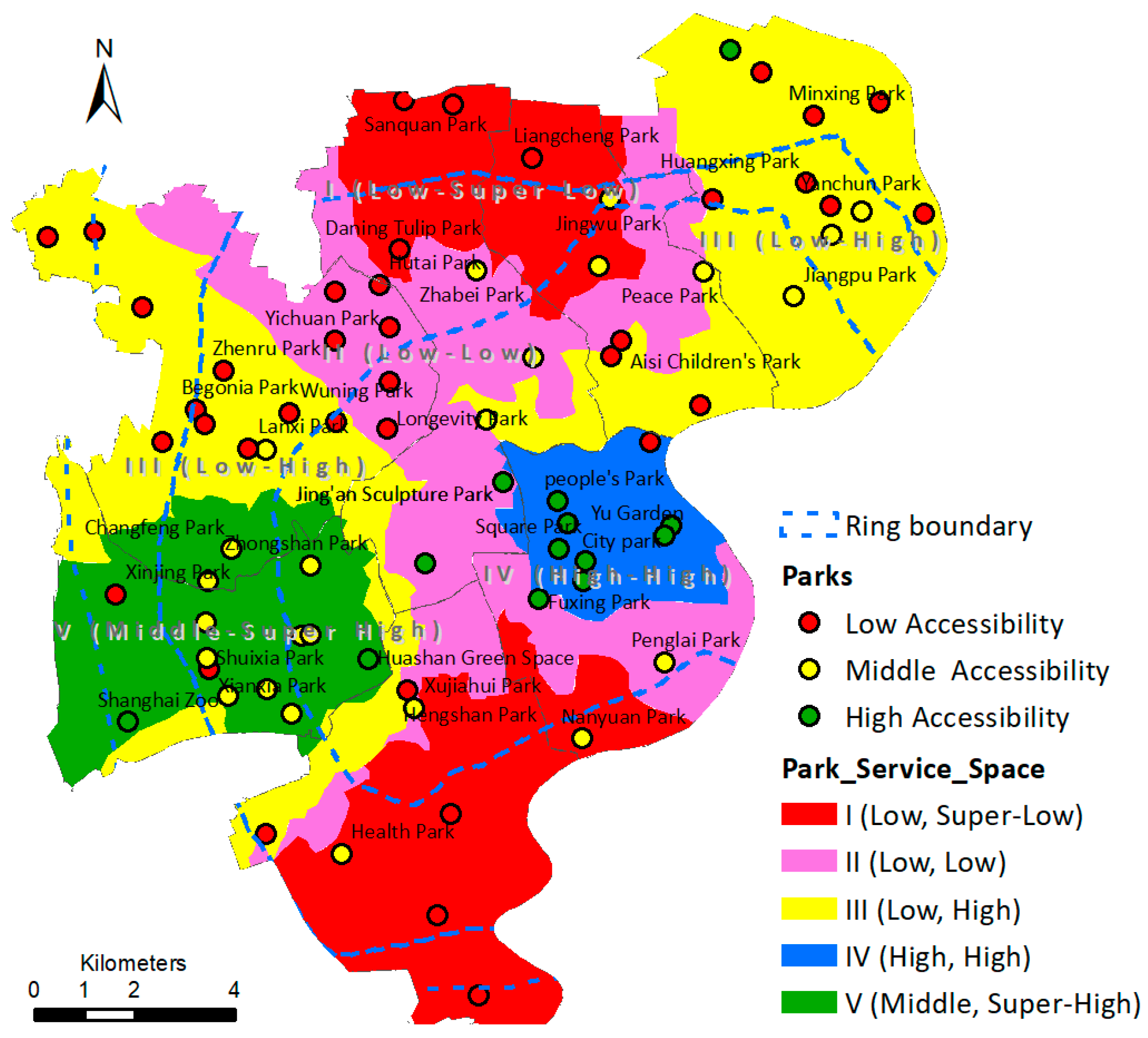
By adding the elderly suitability of all accessible parks within 2 km of each street centroid to the field “Caging” of the corresponding street elements, the elderly suitability of the park service at each street centroid was obtained. Then, using the spatial interpolation method described in Section 3.3.4, the elderly suitability of the park service at any location in the research area was determined. Based on this, since the accessibility can reflect the elderly suitability of parks from a spatial perspective, when exploring the differences and its influencing factors of the elderly suitability of different residential space park service in the research area, we divided the research area into the following park service spaces (Table 4) according to the overlap of the elderly suitability of any location’s park service and the accessibility of all parks (Figure 4).
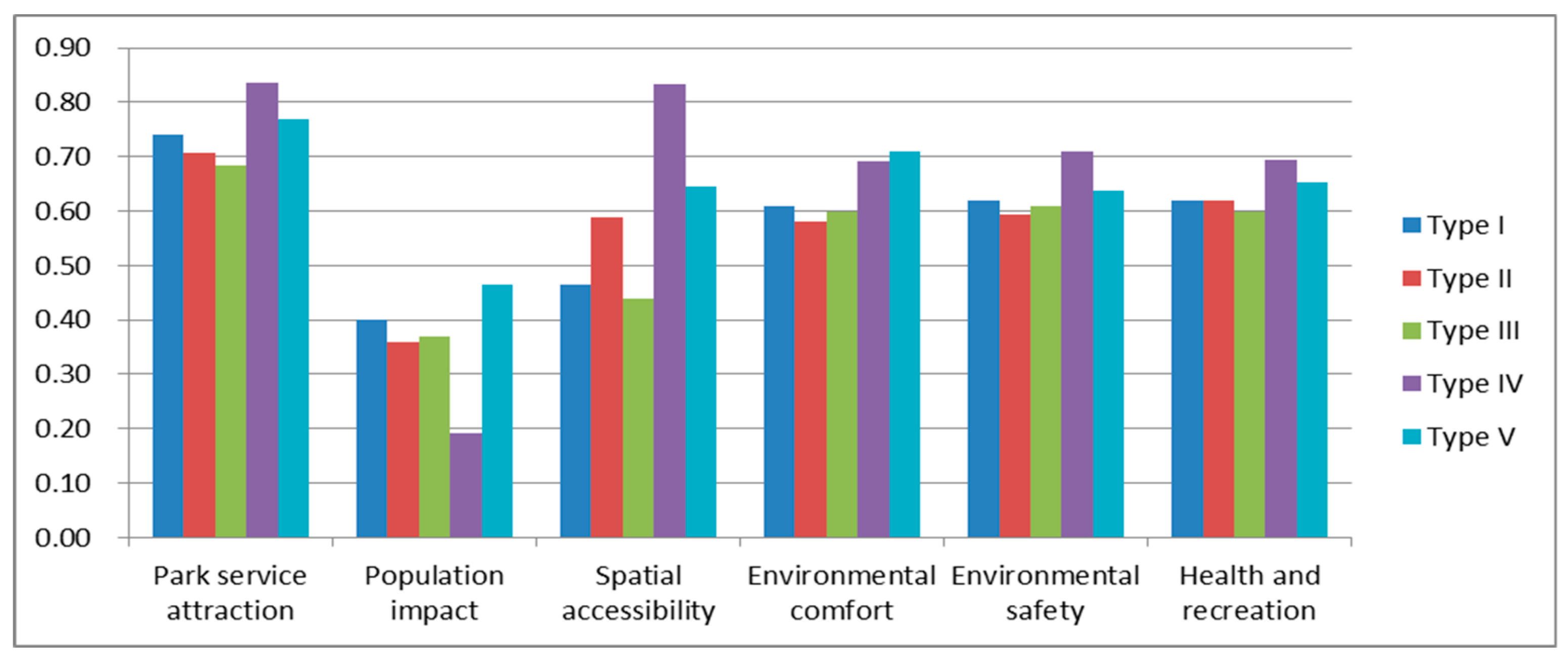
Based on the data from Figure 5, Table 5, and the relevant statistical yearbook, comprehensive analysis suggests that the above formation of the spatial pattern of park service is mainly caused by park service spaces’ population, economy, location, and policy factors. The inner ring of Shanghai Central is the heart of local economic and cultural development. Relying on the regional functional positioning and the development of the tourism economy along the Huangpu River, space type IV (which is located in the inner ring area) is generally better in urban road networks, park facilities, and other amenities. Parks are generally large (that is, of large mean value and small variance, as shown in Table 5), and their attractiveness, accessibility, safety, healthy entertainment, environmental comfort, and other aspects also reach the highest level in the central district. Additionally, since government offices occupy a lot of space in this area (that is, the impact of the population is quite small), the elderly suitability of park services in space type IV is higher. Although the residential space of type II is adjacent to the residential space of type IV, the area, attraction, environmental comfort, and other aspects of the parks in space type II are generally small. Therefore, the accessibility and the elderly suitability of the park services in space type II are both lower.
Relatively speaking, the urban road network and traffic quality outside the inner ring area need to be further improved and the average park accessibility in the residential spaces of types I and III are low. Moreover, because of the large permanent population in Xuhui and Jing’an (1,085,600 and 1,067,800 people, respectively) and the large population density in the north of Hongkou and the south of Huangpu (the population density of these two districts ranked first and second, respectively, in all districts, http://www.stats-sh.gov.cn/tjnj/nj17.htm?d1=2017tjnj/C0202.htm), the elderly suitability of parks in the type I residential spaces are greatly influenced by population factors, so the elderly suitability of their park services are among the lowest in the city.
Compared with space type I, space type III is less affected by population for a variety of reasons. Yangpu and Hongkou have developed tourism along the Huangpu River in recent years, and their urban outlook is improving with each passing day. The environmental comfort and safety of parks in Xinjiangwan city, Wujiaochang, and North Bund have improved rapidly, which has a significant positive impact on the elderly suitability of local parks. Moreover, Putuo is an urban district with a large elderly population, and although most of the parks in this district have a lower elderly-suitability level, the total number of parks in the area is the largest in the city; adding that the southern area is affected by the high elderly-suitability parks of Changning District, the elderly suitability of park services in space type III is higher than that of space type I.
In the residential space of type V, Changning, as a district with a high degree of population aging, has actively enhanced the security and convenience of public facilities and environments following the government guidelines of “happy old-age care” [58] and “Guidelines for the construction of old-age friendly cities” [59]. This has made the attraction, accessibility, comfort, safety, and healthy entertainment of the parks for the elderly in this region reach the leading level in the central district, which is reflected in the high elderly suitability of park services in type V residential spaces.
In summary, the advantages of regional functions and positions, the development of regional culture and tourism economy, and the implementation of regional elderly-care policies have very positive roles in promoting the elderly suitability of the corresponding regional park services in Shanghai Central District. At the same time, the large regional population and high population density constrain the improvement of the elderly suitability of regional park services [60].
6. Conclusions
Research on the continuous improvement of open public spaces for a healthy aging society is still limited [5]. The purpose of this research was to provide a scientific decision-making reference to optimize the elderly suitability of urban parks in Shanghai and other aging cities in China as well as to better guarantee the sustainable development of the city. The results indicated (1) that the elderly suitability of parks in Shanghai Central District decreases gradually from the inner ring to the outer ring and (2) that the park accessibility in Shanghai Central District is generally low and there are five different park service spaces. Furthermore, this paper also shows that, by promoting the development of regional tourism, the good implementation of regional elderly-care policies, and the advantages of regional functional positioning, the elderly suitability of Shanghai urban parks can be improved effectively.
The method created for this study has greatly improved the evaluation efficiency of the elderly suitability of urban parks; it can provide a new way for scholars to solve similar problems. For other cities, if scholars can acquire the geospatial data, the population composition data of the city, and the scoring data of the elderly on the elderly-suitability indicators of urban parks, they can use the method proposed in this paper to customize a personalized evaluation tool for the elderly suitability of parks. This will help them quickly and accurately understand the elderly-suitability condition of urban parks. Moreover, due to the different interests, hobbies, and health concepts of the elderly in different countries and regions, we encourage other scholars to modify the index composition or weight appropriately according to the local situation and the connotation of the elderly suitability of urban parks. This may help to improve the objectivity of their evaluation and the availability of recommendations.
The findings in this paper, combined with the equalization and homogenization requirements for urban public resources in current aging societies and the guidance of China on the construction of the livable environment for the elderly [61], provided important implications for improving the elderly suitability of parks in Shanghai Central District and other similar cities. First, attention should be paid to the indirect promotion of regional culture and tourism economy to the elderly suitability of parks. The high elderly suitability of park service in the districts of Yangpu and Huangpu indicate that regional culture and tourism can open, promote, or coordinate city construction. Therefore, tourism strategies such as heritage tourism [62], eco-tourism [63], and global tourism [64] can be used to improve the construction of urban park environment for the elderly [65] and to thus accelerate the improvement of the elderly suitability of the urban park services [66,67,68]. For example, for the eastern area of Xuhui District and the southern area of Hongkou District, Yangpu and Huangpu can be taken as examples to actively develop tourism economy along the Huangpu River depending on location conditions. Second, attention should be paid to the direct impact of park accessibility on the elderly suitability of parks. In a residential space in which many parks have low accessibility, the elderly suitability of the park service is also very low (Figure 5). This confirms to some extent the important impact of park accessibility on the elderly suitability of a residential space’s park services [18,19]. Therefore, improving park accessibility is a good starting point. In residential spaces where the park service level is still “low, super-low,” “low, low,” or “low, high,” a focus on building old-age friendly traffic, on improving neighborhood accessibility [69], on increasing the number of parks, on increasing the area of parks, on increasing the barrier-free facilities of parks, or on enhancing parks’ attractiveness (e.g., water fountains and other amenities) may help improve the accessibility of parks as well as their suitability for elderly people [16]. Third, steps should be taken to strengthen policy support and demonstration guidance. For urban districts where the elderly suitability of parks and their services are still relatively low, it is crucial to actively seek suitable model areas according to the similarity of location, population, economy, and other factors. For example, central and northern Hongkou, central and western Xuhui, and especially Jing’an and Putuo can examine Changning as a model; can adhere to the “happy old-age pension” index system as a guide; and can enhance the convenience, safety, and daily management of public facilities and public environments in the region.
Since the index scores of some parks came from the comments of the public commentary network (excluding parks that have been visited on the spot), since the setting of index weights was based on expert judgement, and since the maximum travel distance for the elderly was assumed to be 2 km, this study has the following limitations. First, because of the subjectivity of the setting of index weights and because the comments on the public commentary network were mainly from youths (ages < 60), there may be some deviations in the evaluation results of those parks’ elderly suitability. Second, the criterion of maximum travel distance for the elderly is still controversial in academia. This article only determined the distance criterion subjectively according to a few authors’ viewpoints and the common modes of traveling (not just walking) for elderly people in Shanghai. In the future, we plan to do more research on the method of collecting the elderly’s scoring data as well as on the criterion of the maximum travel distance for the elderly. This will make the research conclusions more reliable.
Author Contributions
Conceptualization, W.Y. and B.S.; methodology, W.Y., H.H., and B.S.; software, W.Y. and H.H.; validation, W.Y. and B.S.; formal analysis, W.Y. and B.S.; resources, B.S.; data curation, W.Y.; writing—original draft preparation, W.Y.; writing—review and editing, B.S. and H.H.; supervision, W.Y. and B.S.; project administration, W.Y.; funding acquisition, W.Y. All authors have read and approved the final manuscript.
Funding
This research was funded by the Project of Humanities and Social Sciences Research Planning Foundation of the Chinese Ministry of Education (No. 17YJAZH113).
Acknowledgments
We would like to thank respected editors and anonymous reviewers for their insightful suggestions and comments in improving the quality of the paper.
Conflicts of Interest
The authors declare no conflict of interest.
Appendix A. The Main Functional Code of the Self-Defined Python Script Tool in this Article
The self-defined Python script tool in this article was customized by Python scripting technology oriented to ArcGIS and based on ArcPy. Hence, this part contains two components: the self-defined functions and the main program. The following sentences, which begin with #, are the comments on the codes.
Appendix A.1. The Self-Defined Functions
| import arcpy,math,sys,os |
| reload(sys) |
| #Step 1: Define a function named ConnectShp in order to Connect ShpLyr1 and ShpLyr2, and calculate ShpLyr1.calFld according to exp (a calculation expression). |
| def ConnectShp(ShpLyr1,joinField1,ShpLyr2,joinField2,joinName,exp,calFld): |
| templayer= os.path.split(ShpLyr1)[0]+"\\"+ShpLyr1Name+"tt.shp" |
| arcpy.MakeFeatureLayer_management(ShpLyr1,templayer) |
| arcpy.AddJoin_management(templayer,joinField1,ShpLyr2,joinField2) |
| arcpy.CalculateField_management(templayer,calFld,exp,"PYTHON") |
| arcpy.RemoveJoin_management(templayer,joinName) |
| arcpy.Delete_management(templayer) |
| #Step 2: Define a function named Cacl_1, and its function is that the r1 and r2 field values of the same record are searched in searchlyr and that the r2 field values are added to avitems [r1]. Finally, caclshp.calfld is updated by avitems [i]. |
| def Cacl_1(caclshp,searchlyr,calfld,r1,r2): |
| count = int(arcpy.GetCount_management(caclshp).getOutput(0)) |
| i=1 |
| avitems=[0] # initialization |
| while i<=count: |
| avitems.append(0) |
| i=i+1 |
| with arcpy.da.SearchCursor(searchlyr,[r1,r2]) as cursor: |
| for row in cursor: |
| avitems[row[0]]=avitems[row[0]]+row[1] |
| cursor=arcpy.UpdateCursor(caclshp,"","","","Id") |
| row=cursor.next() |
| i=1 |
| while row: |
| row.setValue(calfld,avitems[i]) |
| cursor.updateRow(row) |
| row=cursor.next() |
| i=i+1 |
Appendix A.2. The Main Program
| #step1: Get parameters that have been entered by the user from the self-defined tool’s running interface (as shown in Figure 2 of this article). |
| B=arcpy.GetParameter(0) # Get friction coefficient. |
| ODAnaLyr=arcpy.GetParameterAsText(1) # Get ArcGIS Origin-Destination cost matrix (.shp). |
| SourLyr=arcpy.GetParameterAsText(2) # Get residential distribution layer (.shp). |
| InfraLyr=arcpy.GetParameterAsText(3) # Get parks distribution layer (.shp). |
| ResultO=arcpy.GetParameterAsText(4) # Set the folder for storing results. |
| #step2: Set field names according to the value of B. |
| if B.isdigit(): |
| # when B is an integer |
| VBFld="V"+B |
| …… # Give names to others fields in the same way. |
| else: |
| # when B is a float |
| VBFld="V"+B.replace(".","_") |
| …… # Give names to others fields in the same way. |
| #step3: Add the above fields for SourLyr, InfraLyr, and ODAnaLyr. |
| arcpy.AddField_management(ODAnaLyr,VBFld,"DOUBLE",12,6) |
| …… |
| #step4: According to, the population impact value VjBFld of each park in InfraLyr is calculated. |
| joinField1= "OriginID" |
| joinField2= "Id" |
| ODAnaLyrName=FileMainName(ODAnaLyr) # Get the main file name from ODAnaLyr. |
| joinName=FileMainName(SourLyr) # Get the main file name from SourLyr. |
| exp1=joinName+".Pop!/pow( !"+ODAnaLyrName+".Total_leng!,"+B+")" # pop stands for population. |
| ConnectShp(ODAnaLyr,joinField1,SourLyr,joinField2,joinName,exp1,VBFld) |
| r1="Destinatio" |
| Cacl_1(InfraLyr,ODAnaLyr,VjBFld,r1,VBFld) |
| #step5: According to, the spatial accessibility from the centroid of residential areas to the centroid of the corresponding parks is calculated (i.e., SourLyr.AiBFld). |
| joinField1= "Destinatio" |
| joinName=FileMainName(InfraLyr) # Get the main file name from InfraLyr. |
| exp2=joinName+".Mj!/(pow(!"+ODAnaLyrName+".Total_leng!,"+B+")*!"+joinName+"."+VjBFld+"!)" #Mj stands for the attraction of parks. |
| ConnectShp(ODAnaLyr,joinField1,InfraLyr,joinField2,joinName,exp2,ABFld) |
| r1="OriginID" |
| Cacl_1(SourLyr,ODAnaLyr,AiBFld,r1,ABFld) |
| #step6: Calculate the contribution value of nonspatial attributes of parks to the elderly suitability of parks according to the weights in the index system, and record it to InfraLyr.NormalSlx. |
| arcpy.AddField_management(InfraLyr,"NormalSlx","DOUBLE",12,6) #Add InfraLyr.NormalSlx |
| exp="!CofFF!*0.09+!CofRF!*0.15+!CofCI!*0.04+!CofRTC!*0.12+!SofRS!*0.06+!LofWP!*0.04+!ADofGL!*0.18+ !CDofPT!*0.03+!EDofS!*0.04+!LofIC!*0.02+!CDofSG!*0.01+!CDofNI!*0.01+!CDofBFA!*0.02" |
| arcpy.CalculateField_management(InfraLyr,"NormalSlx",exp,"PYTHON") |
| #step7: Calculate the elderly-suitability value of each park, and record it to InfraLyr.Paging |
| r1="Destinatio" |
| # Calculating InfraLyr.PaiBFld (i.e. the Spatial Accessibility Value of Parks in InfraLyr) |
| Cacl_1(InfraLyr,ODAnaLyr,PAiBFld,r1,ABFld) |
| Xfld_Std(InfraLyr,"Id",PAiBFld,PAiBStdFld) # Standardize InfraLyr.PAiBFld. |
| exp5="!NormalSlx! + !"+PAiBStdFld+"!*0.19" |
| arcpy.CalculateField_management(InfraLyr,"Paging",exp5,"PYTHON") |
| #step8: Calculate the elderly suitability of park service at each residential area, and record it to SourLyr.Caging. |
| #Assign InfraLyr.Paging to ODAnaLyr.tmpFld2 |
| arcpy.AddField_management(ODAnaLyr,"tmpFld2","DOUBLE",12,6) |
| templayer2= os.path.split(ODAnaLyr)[0]+"\\"+ODAnaLyrName+"tt2.shp" |
| arcpy.MakeFeatureLayer_management(ODAnaLyr,templayer2) |
| arcpy.AddJoin_management(templayer2,"Destinatio",InfraLyr,"Id") |
| InfraLyrFName=FileMainName(InfraLyr) # Get the main file name from InfraLyr. |
| exp3="!"+InfraLyrFName+".Paging!" |
| arcpy.CalculateField_management(templayer2,"tmpFld2",exp3,"PYTHON") |
| arcpy.RemoveJoin_management(templayer2,InfraLyrFName) |
| arcpy.Delete_management(templayer2) |
| #The elderly suitability of park service at each residential area was obtained by adding the elderly suitability of all accessible parks within 2 km of the centroid of each residential area to the field “Caging” of the corresponding residential areas. |
| r1="OriginID" |
| Cacl_1(SourLyr,ODAnaLyr,Caging,r1, tmpFld2) |
References
- Fu, H.; Wu, Y.H. Issues on Living Condition for Aging Population in Sustainable Development City. J. Cap. Norm. Univ. 2000, 21, 86–93. [Google Scholar]
- Yung, E.H.; Conejos, S.; Chan, E.H. Social needs of the elderly and active aging in public open spaces in urban renewal. Cities 2016, 52, 114–122. [Google Scholar] [CrossRef]
- Yung, E.H.; Conejos, S.; Chan, E.H. Public open spaces planning for the elderly: The case of dense urban renewal districts in Hong Kong. Land Use Policy 2016, 59, 1–11. [Google Scholar] [CrossRef]
- Zhu, B.W.; Zhang, J.R.; Tzeng, G.H.; Huang, S.-L.; Xiong, L. Public Open Space Development for Elderly People by Using the DANP-V Model to Establish Continuous Improvement Strategies towards a Sustainable and Healthy Aging Society. Sustainability 2017, 9, 420. [Google Scholar] [CrossRef]
- Heite, E.; Rüßler, H.; Stiel, J. Age (ing) and participative neighbourhood development. Obstacles and perspectives for social sustainability. Z. Gerontol. Geriatr. 2015, 48, 415–425. [Google Scholar] [CrossRef]
- World Health Organization. Multisectoral Action for a Life Course Approach to Healthy Ageing: Draft Global Strategy and Plan of Action on Ageing and Health; World Health Organization: Geneva, Switzerland, 2016; Available online: http://apps.who.int/gb/ebwha/pdf_files/WHA69/A69_17-en.pdf (accessed on 5 October 2016).
- Kestens, Y.; Chaix, B.; Gerber, P.; Desprès, M.; Gauvin, L.; Klein, O.; Klein, S.; Köppen, B.; Lord, S.; Naud, A.; et al. Understanding the role of contrasting urban contexts in healthy aging: An international cohort study using wearable sensor devices (the CURHA study protocol). BMC Geriatr. 2016, 16, 96. [Google Scholar]
- Liu, Y.N. Population Aging and the Sustainable Development of World Cities; Machinery Industry Press: Beijing, China, 2015; pp. 12–13. [Google Scholar]
- Carstens, D.Y. Site Planning and Design for the Elderly: Issues, Guildelines and Alternatives; John Wiley & Sons: Hoboken, NJ, USA, 1993. [Google Scholar]
- Marcus, C.C.; Sachs, N.A. Therapeutic Landscapes: An Evidence-Based Approach to Designing Healing Gardens and Restorative Outdoor Spaces; John Wiley & Sons: Hoboken, NJ, USA, 2013. [Google Scholar]
- Zhang, J.; Zhou, Y.; Yang, C.Z.; Li, Q. Perspective and Progress of Sustainable Urban Study in China. Resour. Dev. Mark. 2015, 31, 86–90. [Google Scholar]
- Zhang, W.F.; Cheng, Y.; Chen, G. Population Problems of the Elderly and Sustainable Development. Chin. J. Gerontol. 2001, 21, 471–475. [Google Scholar]
- Kemperman, A.; Timmermans, H. Green spaces in the direct living environment and social contacts of the aging population. Landsc. Urban Plan. 2014, 129, 44–54. [Google Scholar] [CrossRef]
- Levy-Storms, L.; Chen, L.; Loukaitou-Sideris, A. Older Adults’ Needs and Preferences for Open Space and Physical Activity In and Near Parks: A Systematic Review. J. Aging Phys. Act. 2018, 26, 682–696. [Google Scholar] [CrossRef]
- Gibson, S.C. “Let’s go to the park.” An investigation of older adults in Australia and their motivations for park visitation. Landsc. Urban Plan. 2018, 180, 234–246. [Google Scholar] [CrossRef]
- Levinger, P.; Sales, M.; Polman, R.; Haines, T.; Dow, B.; Biddle, J.H.S.; Duque, G.; Hill, D.K. Outdoor physical activity for older people—The senior exercise park: Current research, challenges and future directions. Health Promot. J. Aust. 2018, 29, 353–359. [Google Scholar] [CrossRef] [PubMed]
- Zhai, Y.; Baran, P.K. Urban Park Pathway Design Characteristics and Seniors’ Walking Behavior. Urban For. Urban Green. 2017, 21, 60–73. [Google Scholar] [CrossRef]
- Zhai, Y.; Baran, P.K. Do configurational attributes matter in context of urban parks? Park pathway configurational attributes and senior walking. Landsc. Urban Plan. 2016, 148, 188–202. [Google Scholar] [CrossRef]
- Xie, B.; An, Z.; Zheng, Y.; Li, Z. Healthy aging with parks: Association between park accessibility and the health status of older adults in urban China. Sustain. Cities Soc. 2018, 43, 476–486. [Google Scholar] [CrossRef]
- Zhai, Y.; Li, K.; Liu, J. A Conceptual Guideline to Age-Friendly Outdoor Space Development in China: How Do Chinese Seniors Use the Urban Comprehensive Park? A Focus on Time, Place, and Activities. Sustainability 2018, 10, 3678. [Google Scholar] [CrossRef]
- Jiang, Y.; Liu, B.; Liu, S.; Wang, L. Comments on the Study of Overseas Green Space Classification System in Urban Areas. Urban Plan. Forum 2007, 51, 109–114. [Google Scholar]
- Zube, E.H. Greenways and the US national park system. Landsc. Urban Plan. 1995, 33, 17–25. [Google Scholar] [CrossRef]
- Van Herzele, A.; Wiedemann, T. A monitoring tool for the provision of accessible and attractive urban green spaces. Landsc. Urban Plan. 2003, 63, 109–126. [Google Scholar] [CrossRef]
- Talen, E.; Anselin, L. Assessing spatial equity: An evaluation of measures of accessibility to public playgrounds. Environ. Plan. A 1998, 30, 595–613. [Google Scholar] [CrossRef]
- Xu, M.; Xin, J.; Su, S.; Weng, M.; Cai, Z. Social inequalities of park accessibility in Shenzhen, China: The role of park quality, transport modes, and hierarchical socioeconomic characteristics. J. Transp. Geogr. 2017, 62, 38–50. [Google Scholar] [CrossRef]
- Almohamad, H.; Knaack, A.; Habib, B. Assessing Spatial Equity and Accessibility of Public Green Spaces in Aleppo City, Syria. Forests 2018, 9, 706. [Google Scholar] [CrossRef]
- Smoyer-Tomic, K.E.; Hewko, J.N.; Hodgson, M.J. Spatial accessibility and equity of playgrounds in edmonton, canada. Can. Geogr. 2004, 48, 287–302. [Google Scholar] [CrossRef]
- Jang, S.; An, Y.; Yi, C.; Lee, S. Assessing the spatial equity of Seoul’s public transportation using the Gini coefficient based on its accessibility. Int. J. Urban Sci. 2017, 21, 91–107. [Google Scholar] [CrossRef]
- Schipperijn, J.; Ekholm, O.; Stigsdotter, U.K.; Toftager, M.; Bentsen, P.; Kamper-Jørgensen, F.; Randrup, T.B. Factors influencing the use of green space: Results from a Danish national representative survey. Landsc. Urban Plan. 2010, 95, 130–137. [Google Scholar] [CrossRef]
- Jorgensen, A.; Anthopoulou, A. Enjoyment and fear in urban woodlands—Does age make a difference? Urban For. Urban Green. 2007, 6, 267–278. [Google Scholar] [CrossRef]
- Scott, D.; Munson, W. Perceived constraints to park usage among individuals with low incomes. J. Park Recreat. Adm. 1994, 12, 79–96. [Google Scholar]
- Higgs, G. A literature review of the use of gis-based measures of access to health care services. Health Serv. Outcomes Res. Methodol. 2004, 5, 119–139. [Google Scholar] [CrossRef]
- Yin, H.W.; Kong, F.H. Accessibility analysis of urban green space in Jinan. J. Plant Ecol. 2006, 30, 17–24. [Google Scholar]
- Comber, A.; Brunsdon, C.; Green, E. Using a GIS-based network analysis to determine urban greenspace accessibility for different ethnic and religious groups. Landsc. Urban Plan. 2008, 86, 103–114. [Google Scholar] [CrossRef]
- McGrail, M.R.; Humphreys, J.S. Measuring spatial accessibility to primary care in rural areas: Improving the effectiveness of the two-step floating catchment area method. Appl. Geogr. 2009, 29, 533–541. [Google Scholar] [CrossRef]
- Guagliardo, M.F. Spatial accessibility of primary care: Concepts, methods and challenges. Int. J. Health Geogr. 2004, 3, 3. [Google Scholar] [CrossRef] [PubMed]
- Song, Z.N.; Chen, W.; Che, Q.J.; Zhang, L. Measurement of Spatial Accessibility to Health Care Facilities and Defining Health Professional Shortage Areas Based on Improved Potential Model. Sci. Geogr. Sin. 2010, 30, 213–219. [Google Scholar]
- Liu, Y.; Song, R.; Li, Z. Evaluating of the Accessibility to rail Transit Based on Spatial Syntax. Urban Rapid Rail Transit 2014, 27, 70–74. [Google Scholar]
- Hu, H.Q.; Chang, L. Planning Cultural Entertainment Facilities Adaptive to the Elderly in Old Residential Areas: A Case Study of Hongmiaobeili Community in Beijing. Archit. J. 2016, 63, 22–27. [Google Scholar]
- Kwan, M.P.; Murray, A.T.; O’Kelly, M.E.; Tiefelsdorf, M. Recent advances in accessibility research: Representation, methodology and applications. J. Geogr. Syst. 2003, 5, 129–138. [Google Scholar] [CrossRef]
- Nicholls, S. Measuring the accessibility and equity of public parks: A case study using GIS. Manag. Leis. 2001, 6, 201–219. [Google Scholar] [CrossRef]
- Li, X.M.; Liu, C.F. Accessibility and service of Shenyang’s urban parks by network analysis. Acta Ecol. Sin. 2009, 29, 1554–1562. [Google Scholar]
- Jin, J.; Qi, K.; Bai, L.F.; Shen, X.Q. The Investigation and Analysis of the Fitness to the Aged of Micro-space in Old Town Based on the Livable Target: With the Example of Nanjing Xinjiekou Subdistrict. Chin. Landsc. Archit. 2015, 31, 91–95. [Google Scholar]
- Deng, Y.; Hu, B. Planning and Design Framework of Urban Public Space for the Elderly Based on Spatial Syntax. Urban Probl. 2016, 35, 53–60. [Google Scholar]
- Chen, Y.S.; Wei, L.L.; Huang, L.S. Research on the Elderly-Friendly Rest Areas in Urban Parks: A Case Study of Xiamen Zhongshan Park. J. Xiamen Univ. Technol. 2017, 25, 60–67. [Google Scholar]
- ArcGIS Help 10.1. OD Cost Matrix Analysis. Available online: http://resources.arcgis.com/en/help/main/10.1/index.html#//00470000004r000000 (accessed on 20 May 2019).
- Wang, F.; Luo, W. Assessing spatial and nonspatial factors for healthcare access: Towards an integrated approach to defining health professional shortage areas. Health Place 2005, 11, 131–146. [Google Scholar] [CrossRef] [PubMed]
- Geertman, S.C.M.; Ritsema, V.E.J.R. GIS and Models of Accessibility Potential: An Application in Planning. Int. J. GIS 1995, 9, 67–80. [Google Scholar] [CrossRef]
- ArcGIS Help 10.1. What Is ArcPy? Available online: https://resources.arcgis.com/en/help/main/10.1/ind-ex.html#//000v000000v7000000 (accessed on 20 June 2019).
- Yang, C. Introduction to GIS Programming and Fundamentals with Python and ArcGIS; CRC Press: Boca Raton, FL, USA, 2017. [Google Scholar]
- Zhang, J.; Wei, W.; Cheng, Y.; Zhao, B. Study on site selection of small and medium-sized city parks based on GIS suitability evaluation. J. Nanjing For. Univ. 2019, 43. [Google Scholar] [CrossRef]
- Khan, A.R.; Rafique, M.; Rahman, S.U.; Basharat, M.; Shahzadi, C.; Ahmed, I. Geo-spatial analysis of radon in spring and well water using kriging interpolation method. Water Sci. Technol. Water Supply 2019, 19, 222–235. [Google Scholar] [CrossRef]
- Metahni, S.; Coudert, L.; Gloaguen, E.; Guemiza, K.; Mercier, G.; Blais, J.F. Comparison of different interpolation methods and sequential Gaussian simulation to estimate volumes of soil contaminated by As, Cr, Cu, PCP and dioxins/furans. Environ. Pollut. 2019, 252, 409–419. [Google Scholar] [CrossRef] [Green Version]
- ArcGIS for Desktop, Kriging. Available online: http://desktop.arcgis.com/en/arcmap/10.3/tools/spatial-analyst-toolbox/kriging.htm (accessed on 2 October 2019).
- Yu, W.Y.; Hu, H. Research on the Evaluation Index System of Urban Leisure Greenland Adaptability for the Elderly. For. Resour. Manag. 2018, 47, 69–75. [Google Scholar]
- Yang, S.G.; Wu, B.J. Evolution Trend and Problems of Suburbanization of Urban Space: A Case Study of Shanghai. Urban Probl. 2009, 28, 57–61. [Google Scholar]
- Dou, X.L.; Pynoos, J.; Feng, C.C. The City and Active Aging: International Initiatives towards Age-friendly Urban Planning. Urban Plan. Int. 2015, 30, 117–123. [Google Scholar]
- NetEase. Blessed Is the Old Man in Changning! Many Old-Age Pension Project Assessment Is the First in the Country, Won National Recognition. Available online: http://dy.163.com/v2/article/detail/E3IKK0D50514C 79Q.html (accessed on 10 May 2019).
- Shanghai Civil Affairs Bureau of China. Notice on Printing and Distributing the Guidelines for the Construction of Old-Age Friendly Cities in Shanghai (Trial). Available online: http://mzj.sh.gov.cn/gb/shmzj /node8/node194/u1ai36526.html (accessed on 1 May 2019).
- Rahman, K.M.A.; Zhang, D. Analyzing the Level of Accessibility of Public Urban Green Spaces to Different Socially Vulnerable Groups of People. Sustainability 2018, 10, 3917. [Google Scholar] [CrossRef] [Green Version]
- China Aged Work Committee Office. Guidance on Promoting the Construction of a Livable Environment for the Elderly. Available online: http://www.cncaprc.gov.cn/contents/12/177185.html (accessed on 20 May 2019).
- Cui, X. Planning for Sustainability in Heritage Tourism—The Case of a Beijing Hutongs. Master’s Thesis, University of Florida, Gainesville, FL, USA, 2010. [Google Scholar]
- Qi, M. The Impact of Ecotourism and Path Analysis to Ecological City of Hebei. Master’s Thesis, Yanshan University, Qinhuangdao, China, 2015. [Google Scholar]
- China Travel News Network. Xinjin County: Promoting the Construction of Park City by Global Tourism Path and Accelerating the Presentation of Beautiful Livable Park City. Available online: http://www.ctnews.com.cn/art/2019/1/16/art_379_33065.html (accessed on 1 October 2019).
- Tokarchuk, O.; Gabriele, R.; Maurer, O. Development of city tourism and well-being of urban residents: A case of German Magic Cities. Tour. Econ. 2017, 23, 343–359. [Google Scholar] [CrossRef]
- Luo, W.; Tan, R. Quantitative study on the coordination of urban tourism and urban development: A case of Hangzhou. Geogr. Res. 2012, 31, 1103–1110. [Google Scholar]
- Huang, J. Research on the Development Strategy Choice of Tourist City under the Regional Tourism Cooperation: The Case of Xiamen City. Tour. Forum 2011, 4, 83–86. [Google Scholar]
- Wang, Y. Research on the development direction of international tourist cities. Product Res. 2010, 25, 120–122. [Google Scholar]
- Krizek, K.J. Residential relocation and changes in urban travel: Does neighborhood-scale urban form matter? J. Am. Plan. Assoc. 2003, 69, 265–281. [Google Scholar] [CrossRef]
Figure 1.
Workflow of evaluation and analysis.

Figure 2.
A self-defined Python script tool for evaluating the elderly suitability of urban parks.

Figure 3.
The spatial distribution map of the elderly suitability of parks.

Figure 4.
The overlap of the elderly suitability of any location’s park service and the accessibility of all parks.
Figure 4.
The overlap of the elderly suitability of any location’s park service and the accessibility of all parks.

Figure 5.
Park index mean.


Table 1.
Summary of the elderly population and park green space in Shanghai Central District.
| Year | Aged 60 and over (Ten Thousand) | Proportion of the Whole City’s Elderly Population | Park Area (hm2) | Proportion of the Whole City’s Park Area |
|---|---|---|---|---|
| 2015 | 187.02 | 45.18% | 2590.82 | 14.56% |
| 2016 | 196.21 | 45.01% | 2686.82 | 14.61% |
| 2017 | 205.26 | 44.84% | 2720.15 | 14.35% |
| 2018 | 215.49 | 44.74% | 2848.3 | 14.38% |
Table 2.
Evaluation index system of the elderly suitability of urban parks.
| General ObjectiveA | First-Level Indexes B (Weight B − A) | Secondary Indexes C | |||
|---|---|---|---|---|---|
| Name | Description | Weight (C − B) | Weight (C − A) | ||
| The elderly suitability of park | Spatial accessibility (0.19) | Traffic distance | The shortest traffic distance from residential area to the park | Calculating by the potential model formula | |
| Friction coefficient | Friction coefficient for the elderly to park along the shortest path | ||||
| Surrounding population | Total population within a certain traffic distance from park | ||||
| Park service attraction | Attraction of park service for elderly | ||||
| Health and recreation (0.28) | Completeness of fitness facilities | The extent to which quantity and category meet the needs of the elderly | 0.33 | 0.09 | |
| Completeness of entertainment facilities | The extent to which quantity and category meet the needs of the elderly | 0.55 | 0.15 | ||
| Children’s interest allocation | The extent to which quantity and category meet the needs of accompanying children | 0.12 | 0.04 | ||
| Environmental comfort (0.43) | Completeness of recreation tables and chairs | The extent to which quantity and category of tables and chairs meet the needs of the elderly | 0.29 | 0.12 | |
| Recreation spatial scale | Size of recreational space | 0.14 | 0.06 | ||
| Walkway spaciousness | The spaciousness of the main pedestrian passages | 0.10 | 0.04 | ||
| Pleasant degree of green landscapes | Overall degree of pleasantness of the green landscapes of the park | 0.41 | 0.18 | ||
| Public toilet allocation | Whether the quantity and location of public toilets are suitable for the elderly | 0.06 | 0.03 | ||
| Environmental safety (0.10) | Degree of spatial enclosure | The degree of recreational space enclosure, including plant/artificial enclosure, etc. | 0.40 | 0.04 | |
| Identity plate clarity | Whether the location of the sign is appropriate or conspicuous | 0.20 | 0.02 | ||
| Configuration degree of soft ground | Scope and degree of soft ground pavement in continuous active space | 0.12 | 0.01 | ||
| Configuration degree of night lighting | Whether there is enough lighting in the park at night | 0.10 | 0.01 | ||
| Barrier-free channel allocation | Whether there is barrier-free access to all kinds of space in the park | 0.18 | 0.02 | ||
Table 3.
Evaluation results of the elderly suitability of parks.
| Park Name | Elderly-Suitability | Park Name | Elderly-Suitability |
|---|---|---|---|
| People’s Park | 0.72 | Taiping Bridge Park | 0.59 |
| New Jiangwan City Park | 0.71 | Shuixia Park | 0.59 |
| Peace Park | 0.70 | Lingnan Park | 0.58 |
| Changfeng Park | 0.70 | Meichuan Park | 0.58 |
| Huaihai Park | 0.69 | Minxing Park | 0.58 |
| Shanghai Zoo | 0.68 | ZTE Green Space | 0.57 |
| Square Park | 0.68 | Never sleep City Green Space | 0.57 |
| Mengqing Garden | 0.67 | Yanhong Green Space | 0.57 |
| Nanyuan Park | 0.67 | Jiangpu Park | 0.56 |
| People’s Square | 0.66 | City park | 0.55 |
| Tianyuan Park | 0.66 | Yanchun Park | 0.55 |
| North Bund Riverside Green Space | 0.66 | Putuo District Sports Park | 0.55 |
| Huangxing Park | 0.65 | Xinjing Park | 0.54 |
| Longevity Park | 0.65 | Sanquan Park | 0.53 |
| Lu Hsun Park | 0.64 | Song Qingling Cemetery | 0.53 |
| Jingwu Park | 0.64 | Hengshan Park | 0.53 |
| Putuo Riverside Green Space | 0.64 | Ganquan Park | 0.53 |
| Renaissance Park | 0.64 | Fuxing Park | 0.52 |
| Future Island Park | 0.63 | Cao Yang Park | 0.52 |
| Jing’an Sculpture Park | 0.63 | Lanxi Park | 0.52 |
| Jing’an Park | 0.63 | Aisi Children’s Park | 0.51 |
| Zhengyue Road Community Sports Park | 0.63 | Xianghe Park | 0.50 |
| Penglai Park | 0.63 | Huajing Park | 0.50 |
| Huashan Green Space | 0.63 | Xinhongqiao Central Garden | 0.50 |
| Sichuan North Road Park | 0.62 | Zhenru Park | 0.49 |
| Huangpu Park | 0.62 | Begonia Park | 0.49 |
| Neijiang Park | 0.62 | Liangcheng Park | 0.48 |
| Siping Science Park | 0.61 | Shanghai Botanical Garden | 0.47 |
| Health Park | 0.61 | Hutai Park | 0.47 |
| Tianshan Park | 0.61 | Taopu Town Green Space | 0.46 |
| Xujiahui Park | 0.61 | Guanlang Park | 0.46 |
| Yangpu Park | 0.60 | Yichuan Park | 0.45 |
| Daning Tulip Park | 0.60 | Putuo Park | 0.45 |
| Caohejing Development Zone Park | 0.60 | Longhua Martyr’s Cemetery | 0.44 |
| Zhabei Park | 0.59 | Gongqing National Forest Park | 0.42 |
| Wuning Park | 0.59 | Xianxia Park | 0.41 |
| Seaweed Green Space | 0.59 | Zhongshan Park | 0.40 |
| Yu Garden | 0.59 | Average | 0.58 |
Table 4.
Division of park service space in research area.
| Space Type | Space Location | Parks and Quantities |
|---|---|---|
| I. Low accessibility, super low elderly-suitability region (“low, super-low”) | North and south ends of the central district | Huajing Park, Shanghai Botanical Garden, Longhua Martyr’s Cemetery, Health Park, Nanyuan Park, Sanquan Park, Lingnan Park, Liangcheng Park, Jingwu Park, Daning Tulip Park, Lu Hsun Park; 11 parks in total. |
| II. Low accessibility, low elderly-suitability region (“low,low”) | Central area of the central district | Zhabei Park, Ganquan Park, Hutai Park, Yichuan Park, Guanlang Park, ZTE Green Space, Longevity Park, Never sleep City Green Space, Penglai Park, Hengshan Park, Xujiahui Park; 11 parks in total. |
| III. Low accessibility, high elderly-suitability region (“low,high”) | The central and western parts of Putuo, the southern part of Hongkou, and all of Yangpu | Jiangpu Park, Yangpu Park, Neijiang Park, Fuxing Island Park, Yanchun Park, Huangxing Park, Gongqing National Forest Park, Minxing Park, Zhengyue Road Community Sports Park, Putuo District Sports Park, Taopu Town Green Space, Future Island Park, Zhenru Park, Begonia Park, Meichuan Park, Xianghe Park, Lanxi Park, Wuning Park, Putuo Park, Huangpu Park, North Bund Riverside Green Space; 21 parks in total. |
| IV. High accessibility, high elderly-suitability region (“high,high”) | The central and northern parts of Huangpu | People’s Park, People’s Square, Square Park, Huaihai Park, Taiping Bridge Park, City park, Yu Garden; 7 parks in total. |
| V. Moderate accessibility, super high elderly-suitability region (“moderate, super-high”) | Changning and some areas of Putuo adjacent to Changning | Xianxia Park, Shuixia Park, Tianshan Park, Tianyuan Park, Changfeng Park, Zhongshan Park, Xinjing Park, Xinhongqiao Central Garden, Yanhong Green Space, Seaweed Green Space, Putuo Riverside Green Space, Song Qingling Cemetery; 12 parks in total. |
Table 5.
Park area.
| Space Type | Variance | Mean (hm2) | Space Type | Variance | Mean (hm2) |
|---|---|---|---|---|---|
| Type I | 20.77 | 14.16 | Type IV | 11.43 | 11.21 |
| Type II | 0.85 | 4.63 | Type V | 14.47 | 9.32 |
| Type III | 34.58 | 9.25 |
© 2019 by the authors. Licensee MDPI, Basel, Switzerland. This article is an open access article distributed under the terms and conditions of the Creative Commons Attribution (CC BY) license (http://creativecommons.org/licenses/by/4.0/).
Share and Cite
MDPI and ACS Style
Yu, W.; Sun, B.; Hu, H. Sustainable Development Research on the Spatial Differences in the Elderly Suitability of Shanghai Urban Parks. Sustainability 2019, 11, 6521. https://0-doi-org.brum.beds.ac.uk/10.3390/su11226521
AMA Style
Yu W, Sun B, Hu H. Sustainable Development Research on the Spatial Differences in the Elderly Suitability of Shanghai Urban Parks. Sustainability. 2019; 11(22):6521. https://0-doi-org.brum.beds.ac.uk/10.3390/su11226521
Chicago/Turabian StyleYu, Weiyi, Bindong Sun, and Hong Hu. 2019. "Sustainable Development Research on the Spatial Differences in the Elderly Suitability of Shanghai Urban Parks" Sustainability 11, no. 22: 6521. https://0-doi-org.brum.beds.ac.uk/10.3390/su11226521
Note that from the first issue of 2016, this journal uses article numbers instead of page numbers. See further details here.