Article

Addressing Geospatial Preparedness Inequity: A Sustainable Bottom-Up Approach for Non-Governmental Development Organizations

by
Roberto San Martin
*,
Marco Painho
* and
Frederico Cruz-Jesus
NOVA IMS, Universidade Nova de Lisboa, 1070-312 Lisbon, Portugal
*
Authors to whom correspondence should be addressed.
Sustainability 2019, 11(23), 6634; https://0-doi-org.brum.beds.ac.uk/10.3390/su11236634
Submission received: 24 July 2019 / Revised: 16 November 2019 / Accepted: 20 November 2019 / Published: 23 November 2019

Abstract

:
In less developed areas, the use of Geographic Information Systems (GIS) to coordinate disaster response is hindered by a lack of geospatial preparedness. Humanitarian missions often rely on OpenStreetMap as a source of information to overcome this limitation. In these places, Non-Governmental Organizations (NGOs) might already be using GIS to implement development projects before the disaster. This study considers the management of geospatial information by those NGOs and whether they could improve geospatial preparedness from within the communities. This bottom-up approach would allow the inclusion of information relevant to the community in the disaster response decision-making process. The research method was an online survey with a worldwide sample of more than 200 development NGOs. The results show that many NGOs use digital geographic information, mostly open-data. They could indeed improve geospatial preparedness while using open-data and community mapping for the implementation of their projects. There is, however, a limitation; most of the development NGOs using open geographic data are not familiar with the open platforms used by the humanitarian community (i.e., OpenStreetMap). Therefore, the study indicates that the sustainability of this synergic approach requires further harmonization between development and humanitarian organizations working for the wellbeing of the same communities.

1. Introduction

Communities are exposed to hazards with different consequences depending on their levels of vulnerability, preparedness, and response. In the aftermath of a disaster, situation, needs, and response capabilities are assessed. Depending on the local capacities and complexity of the disaster, international and multidisciplinary response teams might support the local response. Geographic Information Systems (GIS) are among the tools used to coordinate and facilitate the decision-making process. Geography is a complex reality full of synergies between space, ecosystem, society, culture, and economy. During an emergency response, GIS provides this spatial dimension mainly as a cartographic tool for information sharing, resource allocation, planning, and logistics, and to map population and displacements. Modelling capabilities, optimization methods, problem-solving, and decision support tools (e.g., route and resource allocation) are also of special interest for in-field operations [1,2].
The use of GIS to implement these functionalities requires Geospatial Preparedness. This concept is described by the United States Department of Homeland Security (DHS) as: “… the level of overall capability and capacity necessary to enable all levels of the Department to use geospatial data, geographic information systems software and hardware, and geospatial applications to perform essential functions such as prevention, detection, planning, mitigation, response, and recovery in order to minimize loss of life and property…” [3] (p. 3). There is a geospatial preparedness inequity issue across the world [4]. In some countries, institutions and the private sector count upon skilled staff, tools, and reliable geospatial data, making a holistic approach to disaster management possible. However, in other countries, geospatial information is nearly not considered, and GIS are hardly used. As a consequence, geospatial preparedness is deficient or does not exist [5]. The United Nations Committee of Experts on Global Geospatial Information Management (UN-GGIM) who report about the status of topographic mapping in the world, stated this inequity and pointed to out-of-date information as one of the main issues [6]. Due to the lack of geospatial pre-disaster information in less-developed countries, during disasters, Information Management Officers (IMOs) should produce that information ad hoc, losing precious time and hindering the response coordination [5].
In the aftermath of a sudden-onset disaster happening in a place without adequate resources to cope, the UN Office for the Coordination of Humanitarian Affairs (OCHA) provides coordination, information management, and funding. The first phase is to compare local capacities with the magnitude of the disaster. UN Disaster Assessment and Coordination (UNDAC) teams, including IMOs from partner organizations (i.e., MapAction, ACAPs) might be deployed. The Coordinated Data Scramble project coordinates IMOs from different organizations to remotely support the IMOs in the field. Most IMOs, deployed or supporting remotely, have similar information requirements. This project provides a framework to gather and share, so everybody uses the same data for each particular topic [7,8,9]. In this context, UN institutions are no longer the unique source of information but a coordination point between the affected community, and relief agencies and volunteers. Production and data sharing have become more dynamic, transparent, and decentralized [10].
It is important to consider the actual use of open-data by these IMOs involved in humanitarian operations. The objective of these IMOs is to provide the best datasets available, ideally sourced from governmental data. In the past, that would have been the only source of information considered. However, the response to the 2010 Haiti earthquake showed a significant change, placing collaborative mapping at the centre of the response [11]. Nowadays, OpenStreetMap is often used as an easily available and reliable geographic open-data platform [12]. OpenStreetMap might be considered the main reference of crowdsourced geospatial information in the form of community or collaborative mapping. In parallel, the Humanitarian OpenStreetMap Team (HOT) applies open-source and open-data sharing to humanitarian aid [13,14]. OpenStreetMap can be used, at least, to complement and triangulate existing data and to provide a contact person [15]. During the 2014 West Africa Ebola epidemic, Médecins sans Frontiers (MsF) and Red Cross International decided to crowdsource the task of mapping newly infected areas relying on HOT and Missing Maps [16]. HOT work was also significant in response to the 2015 Nepal earthquake and other major disasters [17,18,19]. Indeed, information management during the 2015 Nepal earthquake shows the development of a new paradigm in data sharing and the use of volunteered geographic information (VGI), especially through OpenStreetMap [20]. Indeed, crowdsourcing post-disaster information through volunteers [21] and the use of deep learning for the same task [22] have focused academic research in this area. Nevertheless, in a previous study [15] it was established that, since IMOs in humanitarian missions consider OpenStreetMap a reliable tool [18,20], improving pre-disaster information in OpenStreetMap improves geospatial preparedness.
However, it is not only mapping but also capacity building that is needed to deliver the long-term cartographic solutions that promote the social sustainability of the community. The projects listed above represent mainly humanitarian organisations mapping communities non-related to them. They are examples of communities depending on external support. Therefore, the disconnection between local communities and volunteer mappers brings concerns about the longer-term sustainability of these projects that do not consider the necessary maintenance and updating of the datasets [23]. This transition from crisis mapping to sustainable and locally-owned community-mapping is only possible with the engagement of the community [4,24].
Moreover, an implementation that breaks the unidirectional top-down flow of information is necessary for Information and Communication Technologies (ICT) capacity building projects to be able to empower the community. ICT should allow communication to also be bottom-up from the community to the establishment, and horizontal within the community [25]. This approach could allow not only breaking the dependency of the community from external support but also could create communities more equitable and connected.
However, in less developed countries, contributions to OpenStreetMap are mainly disaster response related. These event-driven contributions are not in line with the long-term work necessary to use OpenStreetMap as Information and Communication Technologies for Development (ICT4D) [26]. A different approach would be required. Community mapping aiming to develop OpenStreetMap for a particular location has already been successfully implemented in projects such as Map Kibera [27]. Also, the GroundTruth Initiative uses volunteers and handheld GPS to upload information to OpenStreetMap for community mapping. In a different line of work, also built on OpenStreetMap, Development Seed, in partnership with the World Bank, makes Openroads and Rural Accessibility Map available, a suite of tools for least developed countries which allows road mapping and planning and impact modelling. These projects show OpenStreetMap’s potential for democratizing mapping. They also establish the possibility of finding a balance in the debate between process-oriented community mapping vs. goal-oriented professional mapping for targeted results within communities [27]. In addition, development NGOs might use OpenStreetMap data without any payment or limitations since it is free for any purpose through the Open Database License (ODbL1.0) distribution license [28].
IMOs involved in humanitarian operations consider community mapping and NGOs working in development projects reliable sources of data to improve geospatial preparedness [29]. GIS could be a key tool for these organizations, which should be considered within the framework of ICT4D [30]. NGOs working within the community could use OpenStreetMap to cover their information management needs while improving geospatial preparedness. In the reverse direction, needs and aid during disaster response actions could bounce back into development projects.
Therefore, considering that OpenStreetMap is used during disaster response in places lacking geospatial preparedness, that development NGOs could improve geospatial preparedness providing long-term sustainability and that IMOs would trust that information, it is necessary to study the feasibility of these NGOs improving OpenStreetMap. Moreover, in order to consider the possibility of development NGOs using OpenStreetMap to improve geospatial preparedness, it is necessary to understand how these organizations use geospatial information and their relationship with open-data. There are, however, no indications of exhaustive research in this area. Therefore, the present research aims to study the use of geographic information by NGOs working in development projects in areas lacking geospatial preparedness. The object of the study will be referred to using the terms “development NGOs”, and “NGOs working in development projects” alternatively. “Development NGOs” is a rather extensive designation. Conceptually, the study is focused on Non-Governmental Development Organizations (NGDOs) which places the topic on NGOs working within the framework of International Cooperation. As indicated by Makuwira, the generic concept of these NGOs as “organizations that work for the aid and development of others, without direct profit for themselves” includes a great diversity of organizations and it has many nuances [31]. Indeed, given the thin and blurry line separating NGOs in general from NGDOs, it is difficult to estimate the number of organizations that fit in the total target population [32], but it could exceed the hundreds of thousands [31,33].
Moreover, in practical terms, the study contemplates a broader range including NGOs and grassroots associations working in development projects in less developed countries, and locations potentially with a low level of geospatial preparedness. Moreover, the humanitarian and development communities might be difficult to separate. NGOs usually working in development may become part of the humanitarian community supporting the response to a disaster. In addition, some NGOs that usually work in disaster management have projects focused on disaster risk reduction and capacity building that could be considered development projects. Within OpenStreetMap, HOT has, as an objective, to provide a transition from Crowdsourced Mapping to Community Mapping [24]. Other platforms, such as Crowdmap created by Ushahidi [34], Missing Maps, or Tomnod, use OpenStreetMap to work in specific projects in this fuzzy line between humanitarian action and long-term development. However, at this stage of the research, we focused only on NGOs working in development projects. During the selection of the target population, NGOs working mainly in disaster management were not considered. Please refer to the Methodology section for further information about the target population. The approach of the research places a particular focus on the use of geographic open-data. Consequently, this paper aims to answer the following questions: How do development NGOs working in less developed countries use geographic information? Can these organizations improve geospatial preparedness through open platforms such as OpenStreetMap?
After this introduction, the article presents the methodology used for this research and specifies the outcomes related to the subject in question in a series of figures to facilitate the visualization of the results. The paper closes with a discussion on those results and the overall conclusion. The main outcome is that OpenStreetMap is not widely known among the development community; this factor being the main limitation to improve geospatial preparedness.

2. Materials and Methods

This research is based on a multi-method strategy using qualitative and quantitative methods to “triangulate” the findings [35]. In this particular case, the methodology includes a literature review, a semi-structured individual interview with an OpenStreetMap manager, and a questionnaire distributed online to development NGOs.
Since practitioner engagement is necessary for ICT4D research [36], a questionnaire applied to development NGOs was considered the optimal method to investigate the topic. Several geospatial specialists and researchers tested the survey before initiating the study. The online questionnaire was drafted based on the results of previous research [15,
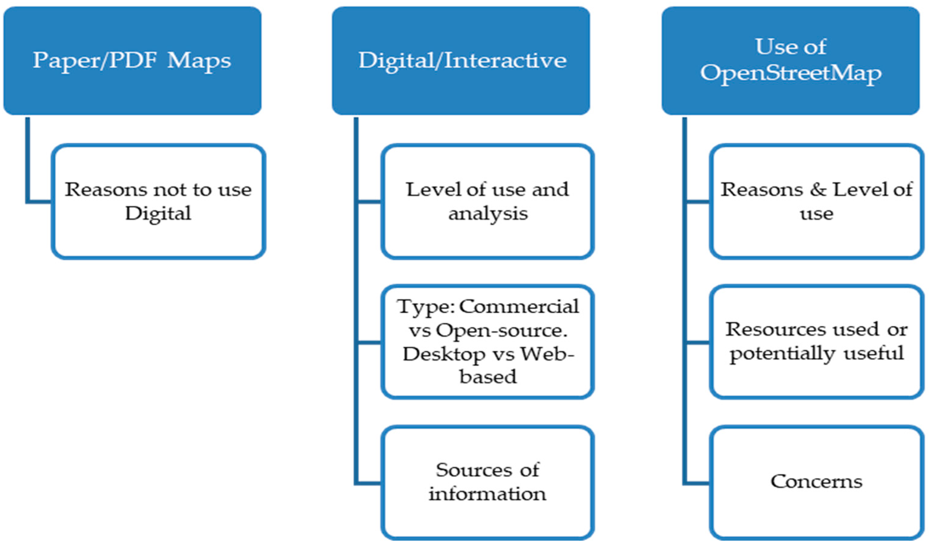
29], the outcomes of the literature review described in the introduction, and a semi-structured interview with an OpenStreetMap representative. The questionnaire included two parts, an initial part to characterize the participant organization with seven mandatory questions and a second part with questions orientated to define the approach to the Sustainable Development Goals and the use of maps by the participant NGOs, as shown in Figure 1. It should be noted that the results of the second part related to Sustainable Development Goals were not used for this article.
For those participants replying positively to the use of maps, the subsequent phase of the questionnaire explored the type of maps considering the format used, as described in Figure 2. A full description of the questionnaire may be found in Supplementary Materials.
The research includes both international and local NGOs considering their geographical scope of intervention. Main international development organizations have IMOs responsible for the management of these tools. On the contrary, small local organizations might not be able to afford the necessary resources. Therefore, both realities should be considered. They could serve the community as external stakeholders or themselves be part of the receiving community [31,33]. The research was conducted globally to avoid country or culture-related biases. Purposive sampling techniques [35] were used to identify NGOs from several databases (i.e., OnGood by the Public Interest Registry formed by the Internet Society, Civil Society Organizations System developed by the UN Department of Economic and Social Affairs, Organizations listed in The Idealist, Forus network of National NGO Platforms and Regional Coalitions, Latin American Network Information Center, Participants Of The Netzkraft Movement, Civil Society in the Commonwealth of Nations, and the Non-Governmental Organization Network of the Global Environment Facility). In the second stage, other networks and partners of the initial sample were used to identify further NGOs within the target population. NGOs that might have disaster management as their main activity were disregarded. The survey was online for three months from September 2018. The resulting sample of 2684 NGOs was contacted by email or contact forms on the organization’s website, with a description of the study and a link to the questionnaire. In order to increase the sample size, the invitation to participate in the study requested to cascade the call to include further NGOs within the target population. From 383 responses to the questionnaire (over 14% of the number of development NGOs contacted), partial replies were disregarded and only completed replies were considered for analysis. The analysis of the Internet Protocol (IP) address of the device used to complete the questionnaire led to dismissing further answers to avoid duplications. The final sample was therefore 204 answers. This sample was considered representative of the target population in view of the characterization of the participants and their geographical location as shown in 
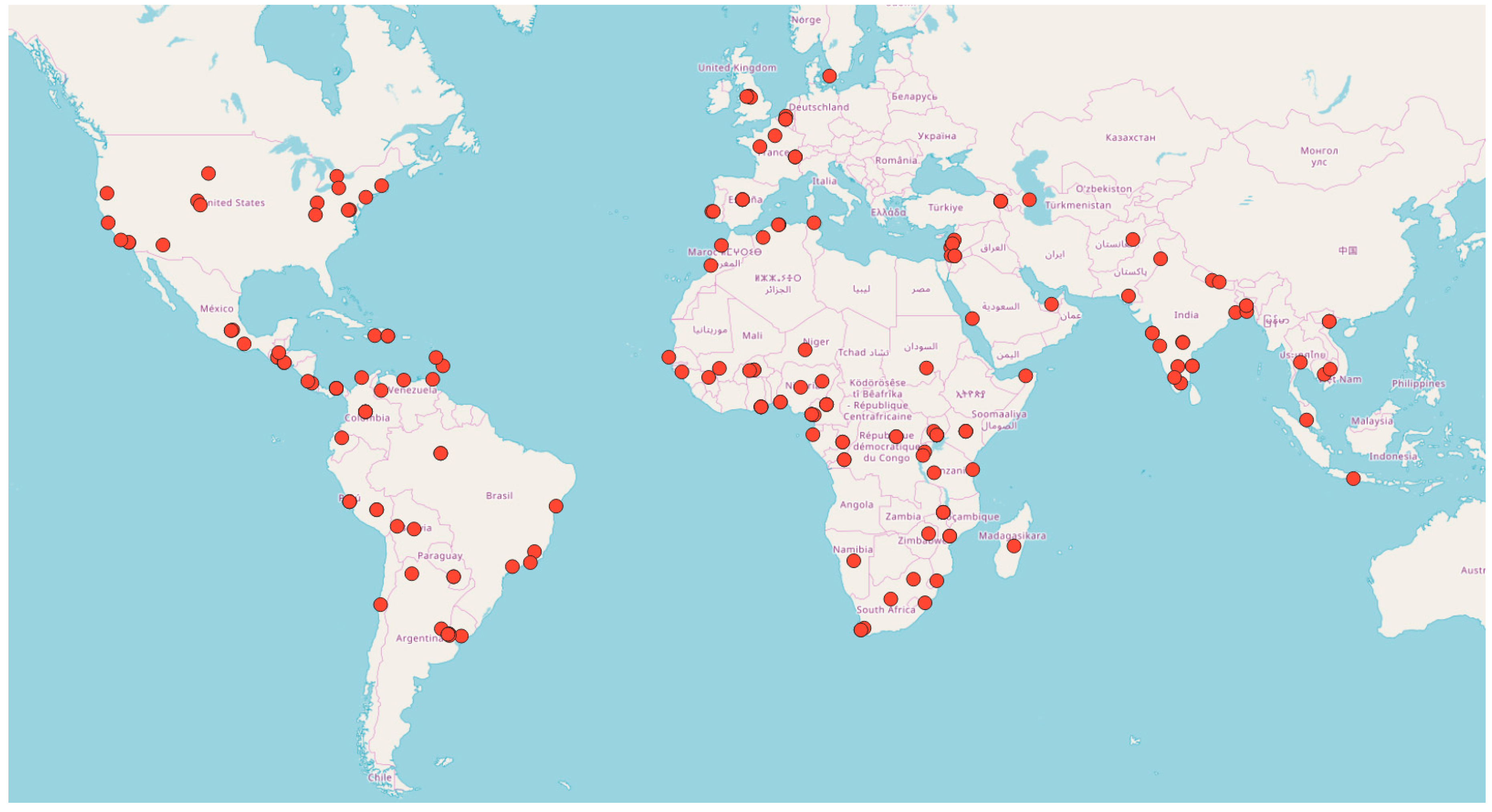
Figure 3. Data was anonymized and treated in an aggregated way. Therefore, all responses remained confidential.

3. Results

3.1. Characterization of the Sample

The participants included all ranges of development NGOs based on size (considering the number of paid staff and annual implementation budget), working strategy, areas of work, and geographical scope of project implementation as shown in Figure 4. The sample characterizes the different sub-sets of the targeted population proportionally represented. It is interesting to note the large representation of small development NGOs, both considering number of paid staff (34 relying only on volunteers and 94 with less than 10 personnel which would total 63% of the sample) and budget (60 under USD 25,000 and a further 75 under USD 200,000 which would total 66%), working in local grassroots projects (97 participants 47%). The rural vs. urban division is also well represented with half of the sample (103 NGOs) working in both. Finally, the development NGOs that did not count on a dedicated IMO represent a large portion of the sample (59% accounting for 120 participants).

3.2. Use of Geographic Information by Development NGOs

There is a substantial percentage of development NGOs (38% of the sample that amounts to 78 participants) that do not use geographic information in the form of maps for their work, as Figure 5a shows. The main reasons not to use geographic information are the lack of equipment followed by the lack of staff and know-how. Further reasons are described in Figure 6a.
For those NGOs using geographic information, digital maps allowing for interaction with the geographic information are the preferred format, as reflected in Figure 5b (74%, which means that from the 123 participants that do use maps, 89 mainly use this format).
When considering the 26% (31 participants) that use mainly paper/PDF format, again, the lack of equipment was presented as the main reason not to use digital format. Further reasons are presented in Figure 6b. All the participants presenting the lack of equipment as the reason not to use digital maps confirmed that they have access to the internet and a cheap smartphone.
As for the 123 participants using geographic information in the form of maps, the main use is project planning and monitoring as shown in Figure 7. It is also interesting to note the high number of NGOs involved in community mapping (62 development NGOs are involved in this task which means 56% of map users). Among the “other” uses, there are some NGOs (6 participants) using maps for some type of research. Maps are considered necessary and/or useful by the participants using them. When asked about the reasons to use maps, 87 participants answered that maps are necessary while 82 considered them useful. There is also a certain number of development NGOs (21 participants) that use maps because donors request them. Nevertheless, none of the participant NGOs claimed donor request as the only reason to use maps.

3.3. Use of Open-Source by Development NGOs

Open-source was expected to be an interesting option for development NGOs. The study confirmed this point. Figure 8a displays the types of software used by the development NGOs. Thirty-five participants stated desktop open-source, with a similar number using web-based open-source, as the GIS software used for the management of geographic information. Analyzing these answers in the context of the 89 participants using geographic information in digital format, Figure 8b shows the percentage of users of open-source vs. commercial software. From the results, it might be established that open-source software is the preferred option (41 development NGOs rely exclusively on open-source software and 16 more use it together with commercial options).
The sources of geographic information considering the 89 participants using digital maps are displayed in Figure 9a. It is interesting to find that gathering the information directly is the main source. Open-data, governmental data, and data obtained from partner organizations are almost equally used. When only considering the sub-set of 57 participants that use open-source software (in some cases together with commercial software), the use of open-data gains importance as shown in Figure 9b.

3.4. Use of OpenStreetMap by Development NGOs

From the 123 NGOs using geographic information in the form of maps, only 26 participants (21%) use OpenStreetMap as displayed in Figure 10a. If the sub-set of 57 users of open-source software is considered independently, the percentage of OpenStreetMap users rises to 26% (15 participants). From the 26 users of OpenStreetMap, 69% (18 participants) recognize that the main task is just as a basemap (see Figure 10b).
Some of the NGOs using OpenStreetMap (26 participants) have concerns about the use of an open platform. Figure 11 presents how security and accuracy are the main concerns when using these types of platforms. In addition, no concerns were expressed by 15% of the development NGOs (4 participants).
With regard to the 97 users of maps that do not use OpenStreetMap, the main reason offered was that they did not know OpenStreetMap before completing the questionnaire. The reasons behind the lack of adhesion to OpenStreetMap are displayed in Figure 12 Only three NGOs pointed to security concerns as the only reason not to use OpenStreetMap while just one did so over privacy. Two participants considered a lack of accuracy as the only reason not to use it. In two other cases the participants do not use OpenStreetMap because they use Google Maps.
In terms of the 174 participants that do not use OpenStreetMap (considering those using maps and those that do not use them), 72% (125 participants) found an OpenStreetMap application that could be useful for their organizations. Figure 13 displays the opinion of these participants regarding the different OpenStreetMap services that could be of use for their organizations.

4. Discussion

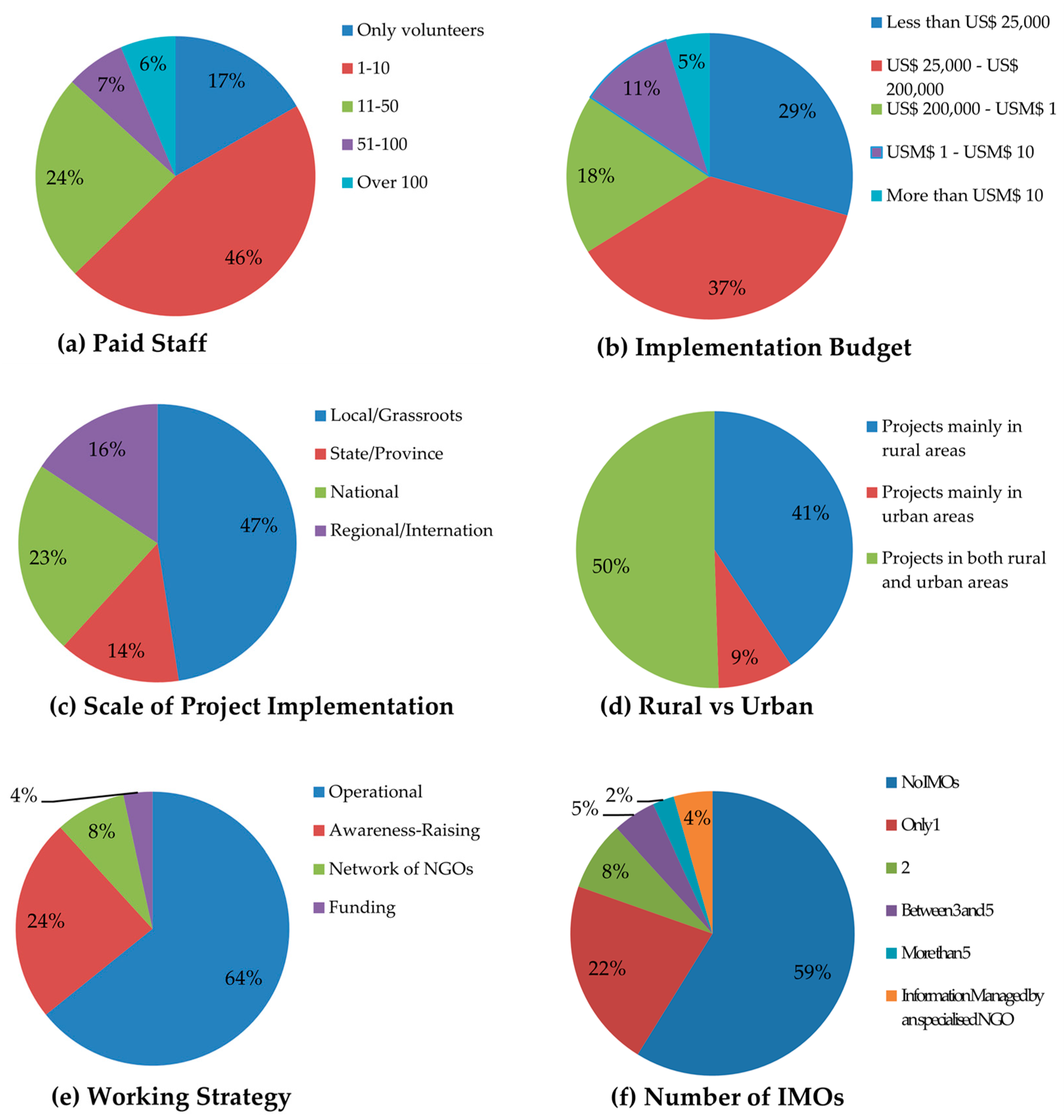
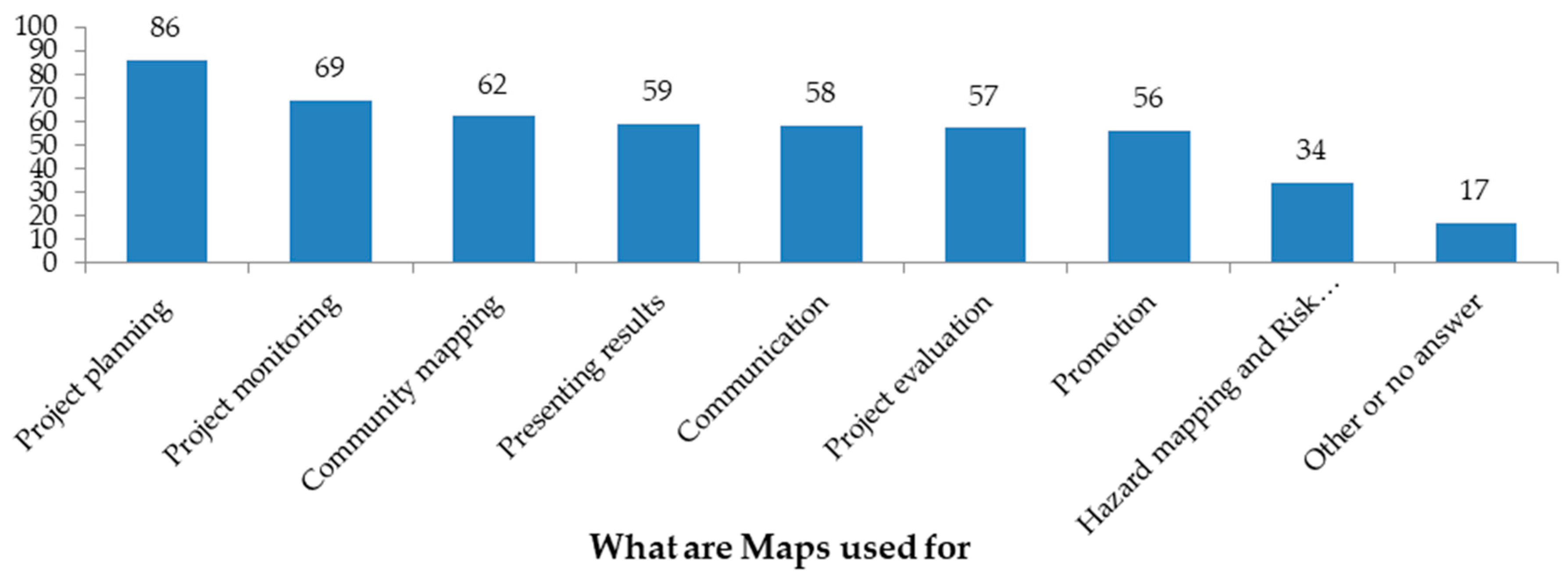
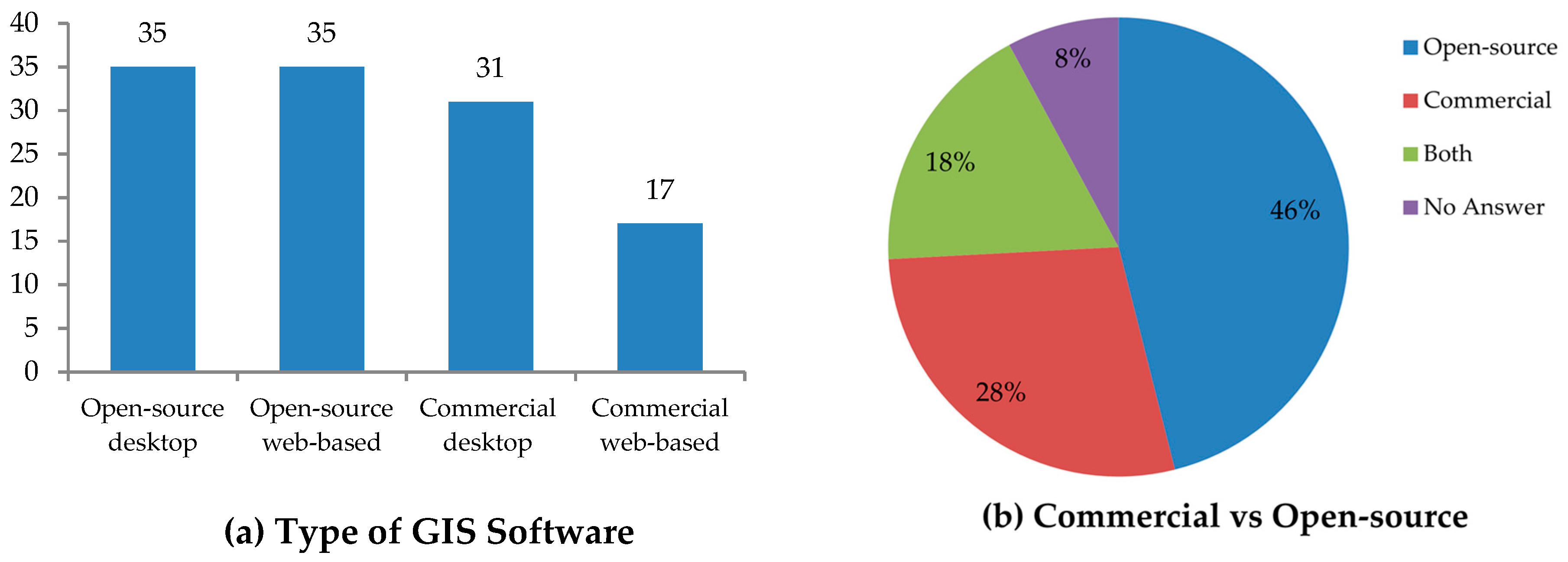
The benefits of using geographic information are clear for those participants who actually use it. NGOs using maps do so during all phases of their development projects, from planning to implementation and evaluation. Maps are also used to communicate, to promote projects or organizations, and to present results. There are other uses for this information, and among them, community mapping should be highlighted. Further research is necessary to establish the objectives, tools used, and methodology followed by development NGOs conducting community mapping and how it could be embedded in capacity building initiatives. The maps used by development NGOs are mostly in a digital format that allows for interaction with the information. The use of paper maps or in PDF format is indeed quite limited. Development NGOs might have dedicated IMOs (37% of the participants) or development practitioners taking over information management among other tasks (59% of the participants). Both consider geographic information for their work, and GIS are a common tool. Open-source GIS, either desktop or web-based, is the most common software among these users of digital information, even if in some cases open-source options are used together with commercial ones. In addition, it should be noted that the use of open-source GIS software usually runs together with the use of open-data as the main source of information.
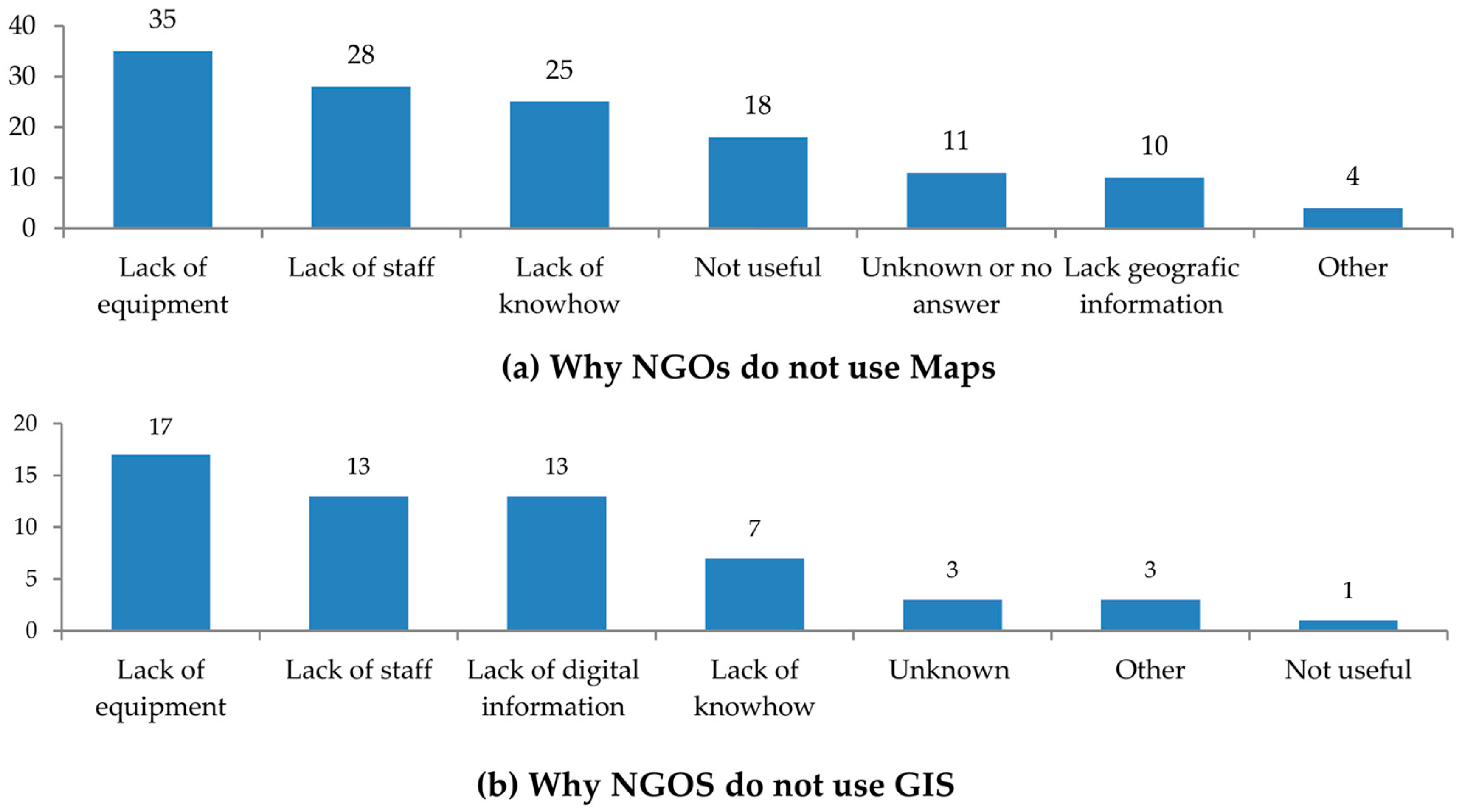
Regardless of the benefits of using geographic information, some development NGOs do not use maps in any format. The lack of equipment is pointed out as the main reason not to use digital maps or not to use maps altogether. However, the same participants confirmed that they have access to the internet and a cheap smartphone. They consider many of the possible applications of GIS and open platforms (i.e., OpenStreetMap) interesting for their work. Nevertheless, the use of geographic information is limited by the idea that specialized equipment is needed when the reality is that it is not. The OpenStreetMap representative confirmed that a cheap smartphone and internet access is all that is needed to take advantage of their tools and services. This issue could be explained by Sen’s capabilities approach, in which “what people have” is replaced by “what people can do” [37]. Development is understood as a process where people help each other to gain entitlements, to obtain access capacity [
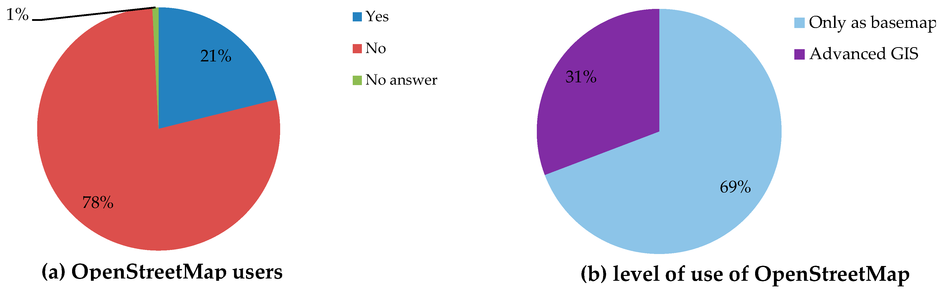
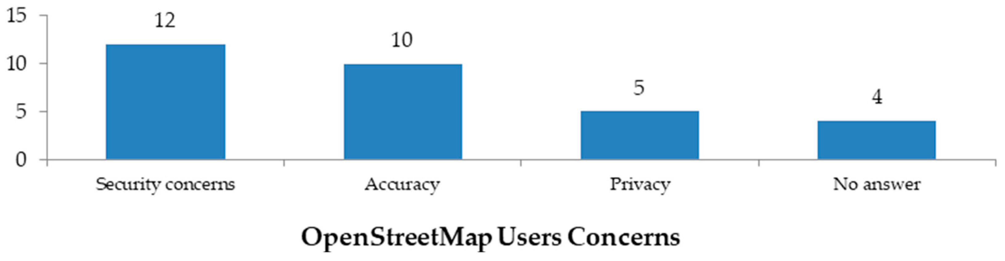
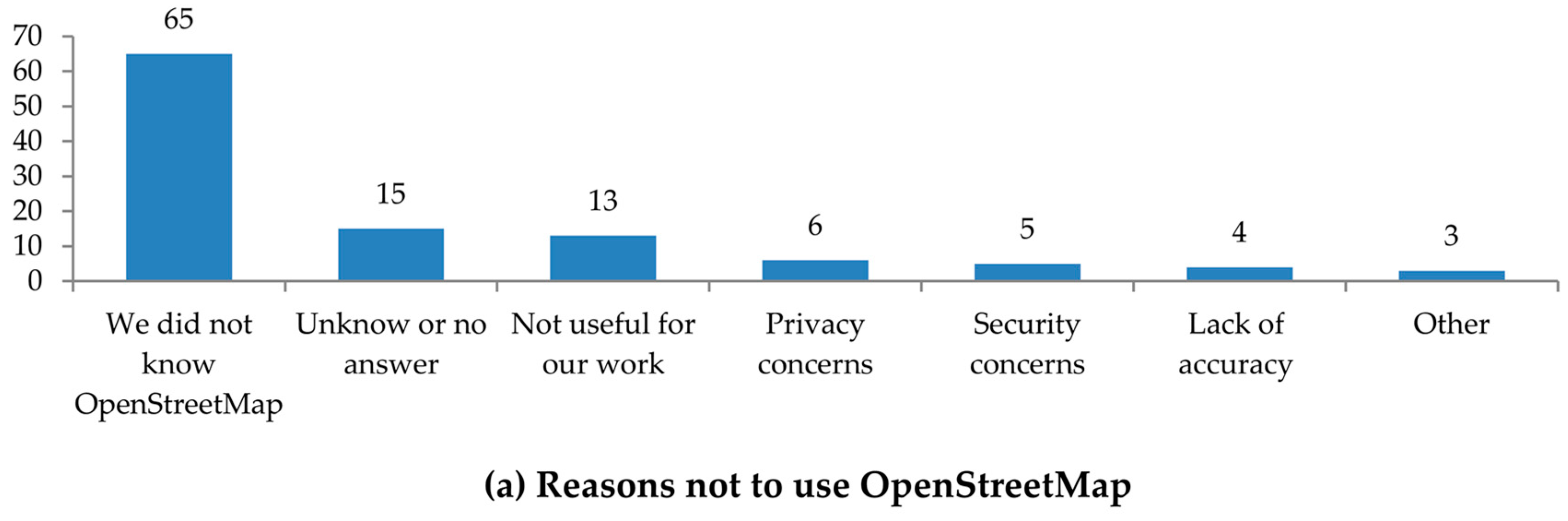
38]. In this case, development NGOs not using maps need to learn that the equipment they “have” is sufficient so they “can” gain the capacity to use geographic information in the form of digital maps. Likewise, the use of OpenStreetMap presents similar circumstances. NGOs consider that OpenStreetMap tools and services could be useful for their work. However, most of the participants in the study do not use them. The reason behind the lack of adhesion to OpenStreetMap is mainly because the participants did not know about the open-platform before contributing to the study. Therefore, development NGOs would need to learn about the existence of OpenStreetMap and the capabilities of the platform so they could gain the entitlement to access these tools and services. Further research is required to consider the use of other crowdsourced platforms by the development community.
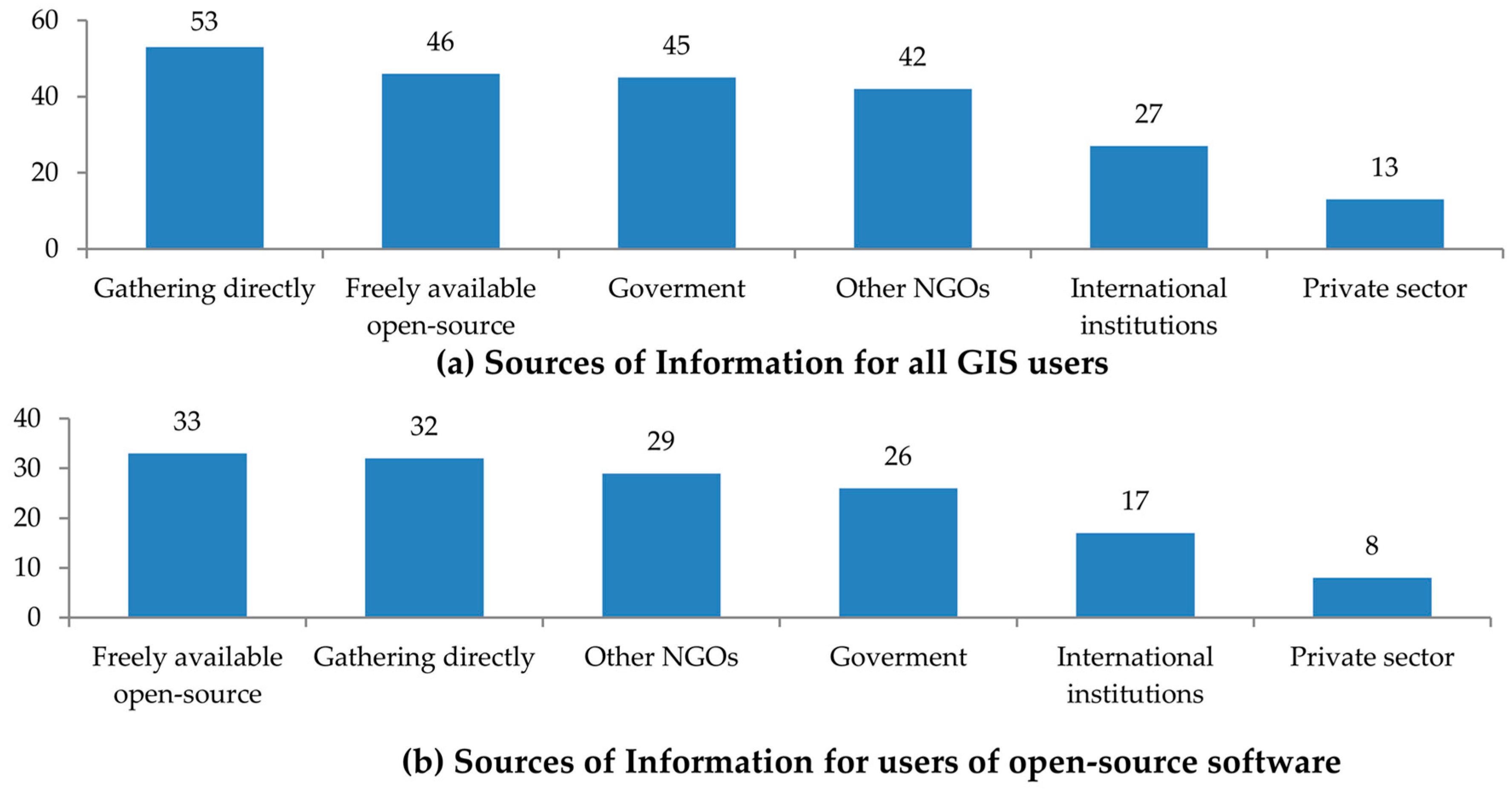
Another issue presented as a reason not to use GIS is the lack of digital information. This issue could be solved if more organizations gathered information and shared it on an open platform such as OpenStreetMap. Indeed, the main source of information for most of the development NGOs using GIS is to gather their own. In addition, many also use data from other NGOs and freely available open-data. The widespread implementation of open-data policies among development NGOs could initiate a virtuous cycle in which the availability of data would drive more NGOs to use GIS and to create more open-data. The ownership of the project by the community would ensure the maintenance of the information and that it would be kept up to date. This approach would empower the community allowing for a horizontal transfer of information within the community, and bottom-up from the community to the establishment. The inequity in the access to information would be reduced allowing for a more sustainable community. The main issue is that, while IMOs involved in humanitarian missions do use OpenStreetMap, a great number of those managing information for NGOs working in development projects do not even know about the existence of this open platform. The results of the study do not show a link between this fact and the use of dedicated IMOs or their background. In order to establish the causes of this lack of knowledge and how to solve it would require further research. Moreover, OpenStreetMap is considered by many in the academic world as paramount to open platform for community mapping. Studies should consider this ambiguity between development practitioners and researchers.
The actual approach to close the gap in geospatial preparedness using OpenStreetMap might be focused in the use of remote sensing imagery analyzed by volunteers working remotely or computers using machine learning. This approach might be able to map the areas. However, it does not offer a socially sustainable alternative since it would lose the reality of those communities.
The present study is limited by the use of a digital platform to conduct the survey. Obviously, the fact that the survey was conducted online supposes that all participant NGOs should have internet access, in principle. This aspect, however, does not affect the validity of the survey results. Nevertheless, the existence of a more intense digital divide created by the lack of access to the internet should be the object of further research.

5. Conclusions

A sizable number of development NGOs do not consider geospatial information. Some NGOs deem that they lack the necessary equipment to handle digital geographic information. Capacity building initiatives are needed to provide the know-how that would allow them to create and use geospatial data. These NGOs could learn that the use of open geographic data does not require special resources while the benefits could be spread through the whole community. Nevertheless, the results of the study show that, for those development NGOs already using geographic information, a majority use it in a digital format that allows for interaction with the information. In this case, the main limitation in becoming a source of information to improve geospatial preparedness for humanitarian institutions is the lack of harmonization between the tools used by these communities. Humanitarian missions rely on OpenStreetMap as a source of information. The use of this open platform by development NGOs could improve the availability of open-data and geospatial preparedness for disaster response by humanitarian missions. In addition, this capacity building approach would empower the community allowing for a new paradigm in the transfer of information. This process would facilitate the transfer of information within the community and the connection of the community to the outside world. The information significant to the community would become part of the information considered by the decision makers supporting that very same community in the aftermath of a disaster. In parallel, the ownership of the project by the community would ensure long-term sustainability since the community would maintain and keep the information up-to-date. Indeed, development NGOs use geographic information and GIS open-source software for community mapping and the implementation of development projects. The main issue is that OpenStreetMap is not widely known among the development community. The reasons behind this lack of knowledge should be the object of further research. The interaction between humanitarian and development communities could be more frequent, becoming more open and transparent. Development NGOs that already use open-data should consider OpenStreetMap as an option for the management of digital geographic information. This approach would allow the harmonization of tools used by development NGOs and humanitarian missions working for the well-being of the same communities. In addition, these development NGOs, as representatives of the local community, would improve geospatial preparedness creating a framework that could break the dependency on external support.

Supplementary Materials

Author Contributions

Conceptualization, R.S.M.; methodology, R.S.M. and M.P.; validation, F.C.-J.; investigation, R.S.M.; writing—original draft preparation, R.S.M.; writing—review and editing, M.P. and F.C.-J.; supervision, M.P.

Funding

This research received no external funding.

Conflicts of Interest

The authors declare no conflicts of interest.

References

  1. Shorbi, M.; Wan Hussin, W.M.A. The use of Spatial Data in Disaster Management. TI J. World Appl. Program. 2015, 5, 73–78. [Google Scholar]
  2. Tomaszewski, B.; Judex, M.; Szarzynski, J.; Radestock, C.; Wirkus, L. Geographic Information Systems for Disaster Response: A Review. J. Homel. Secur. Emerg. Manag. 2015, 12, 1–32. [Google Scholar] [CrossRef]
  3. DHS. Geospatial Management Office Management Directive System; MD Number: 4030; DHS: Washington, DC, USA, 2004. [Google Scholar]
  4. Sumadiwiria, C. Putting Vulnerable Communities on the Map: A Research Report on What Influences Digital Map-Making with Young Volunteers in Bangladesh; Y-Care International: London, UK, 2015. [Google Scholar]
  5. San Martin, R.; Painho, M. Inequity and development in geospatial preparedness. In Proceedings of the 22nd Annual International Sustainable Development Research Society Conference Rethinking Sustainability Models and Practices: Challenges for the New and Old World Contexts, Lisbon, Portugal, 13–15 July 2016; Volume 3, pp. 12–24. [Google Scholar]
  6. Konecny, G.; Breitkopf, U.; Radtke, A. The Status of Topographic Mapping in the World a UNGGIM - ISPRS Project 2012–2015. In Proceedings of the The International Archives of the Photogrammetry, Remote Sensing and Spatial Information Sciences, Prague, Czech Republic, 12–19 July 2016; Volume XLI-B4, pp. 737–741. [Google Scholar]
  7. Verity, A. Verity Think Blog. Available online: http://blog.veritythink.com/post/145957370879/i-scramble-you-scramble-we-all-scramble-for (accessed on 13 May 2019).
  8. Campbell, H. Coordinated Data Scramble. Available online: https://www.youtube.com/watch?v=HmsF743VRX0 (accessed on 13 May 2019).
  9. Van den Homberg, M. Toward a Balkans’ Data for Disaster Management Collaborative? In Implications of Climate Change and Disasters on Military Activities. NATO Science for Peace and Security Series C: Environmental Security; Nikolov, O., Veeravalli, S., Eds.; Springer: Dordrecht, The Netherlands, 2017; pp. 11–18. [Google Scholar]
  10. Kawasaki, A.; Berman, M.L.; Guan, W. The growing role of web-based geospatial technology in disaster response and support. Disasters 2013, 37, 201–221. [Google Scholar] [CrossRef] [PubMed]
  11. De Albuquerque, J.P.; Eckle, M.; Herfort, B.; Zipf, A. Crowdsourcing geographic information for disaster management and improving urban resilience: An overview of recent developments and lessons learned. In European Handbook of Crowdsourced Geographic Information; Ubiquity Press: London, UK, 2016; pp. 309–321. [Google Scholar]
  12. Westrope, C.; Banick, R.; Levine, M. Groundtruthing OpenStreetMap Building Damage Assessment. Procedia Eng. 2014, 78, 29–39. [Google Scholar] [CrossRef]
  13. See, L.; Mooney, P.; Foody, G.; Bastin, L.; Comber, A.; Estima, J.; Fritz, S.; Kerle, N.; Jiang, B.; Laakso, M.; et al. Crowdsourcing, Citizen Science or Volunteered Geographic Information? The Current State of Crowdsourced Geographic Information. ISPRS Int. J. Geo-Inf. 2016, 5, 55. [Google Scholar] [CrossRef]
  14. See, L.; Estima, J.; Podor, A.; Arsanjani, J.J.; Laso Bayas, J.-C.; Vatseva, R. Sources of VGI for Mapping. In Mapping and the Citizen Sensor; Foody, G., See, L., Fritz, S., Mooney, P., Olteanu-Raimond, A.-M., Costa Fonte, C., Vyron, A., Eds.; Ubiquity Press Ltd: London, UK, 2017; pp. 13–36. ISBN 9781911529163. [Google Scholar]
  15. San Martin, R.; Painho, M. Geospatial preparedness: Empirical study of the joint effort to provide geospatial support to disaster response. Trans. GIS 2019. [Google Scholar] [CrossRef]
  16. Koch, T. Mapping Medical Disasters: Ebola Makes Old Lessons, New. Disaster Med. Public Health Prep. 2015, 9, 66–73. [Google Scholar] [CrossRef] [PubMed]
  17. Poiani, T.H.; Rocha, R.D.S.; Degrossi, L.C.; Albuquerque, J.P. De Potential of collaborative mapping for disaster relief: A case study of openstreetmap in the Nepal earthquake 2015. In Proceedings of the Annual Hawaii International Conference on System Sciences, Koloa, HI, USA, 5–8 January 2016; pp. 188–197. Available online: https://www.researchgate.net/publication/282090569_Potential_of_Collaborative_Mapping_for_Disaster_Relief_A_Case_Study_of_OpenStreetMap_in_the_Nepal_Earthquake_2015 (accessed on 22 November 2019).
  18. Givoni, M. Between micro mappers and missing maps: Digital humanitarianism and the politics of material participation in disaster response. Environ. Plan. D 2016, 34, 1025–1043. [Google Scholar] [CrossRef]
  19. Dittus, M.; Quattrone, G.; Capra, L. Mass Participation During Emergency Response: Event-centric Crowdsourcing in Humanitarian Mapping. In Proceedings of the CSCW; ACM DL: Portland, OR, USA, 2017; pp. 1290–1303. [Google Scholar]
  20. Soden, R.; Palen, L. Infrastructure in the Wild: What Mapping in Post—Earthquake Nepal Reveals about Infrastructural Emergence. In Proceedings of the 2016 CHI Conference on Human Factors in Computing Systems, San Jose, CA, USA, 7–12 May 2016; ACM: New York, NY, USA, 2016; pp. 2796–2807. [Google Scholar]
  21. Kankanamge, N.; Yigitcanlar, T.; Goonetilleke, A.; Kamruzzaman, M. Can volunteer crowdsourcing reduce disaster risk? A systematic review of the literature. Int. J. Disaster Risk Reduct. 2019, 35. [Google Scholar] [CrossRef]
  22. Chen, J.; Zhou, Y.; Zipf, A.; Fan, H. Deep Learning from Multiple Crowds: A Case Study of Humanitarian Mapping. IEEE Trans. Geosci. Remote Sens. 2019, 57, 1713–1722. [Google Scholar] [CrossRef]
  23. Turk, C. Cartographica incognita: ‘Dijital Jedis’, Satellite Salvation and the Mysteries of the ‘Missing Maps’ Cartographica incognita: ‘Dijital Jedis’, Satellite Salvation and the Mysteries of the ‘Missing Maps’. Cartogr. J. 2016, 1–10. [Google Scholar] [CrossRef]
  24. Soden, R.; Palen, L. From Crowdsourced Mapping to Community Mapping: The Post-earthquake Work of OpenStreetMap Haiti. In Proceedings of the 11th International Conference on the Design of Cooperative Systems; Rossitto, C., Ciolfi, L., Martin, D., Conein, B., Eds.; Springer International Publishing Switzerland: Nice, France, 2014; pp. 27–30. [Google Scholar]
  25. Gigler, B.-S.; Bialur, S. Introduction: The Potential for Empowerment through ICTs. In Closing the Feedback Loop: Can Technolog Bridget the Accountability Gap? The World Bank: Washington, DC, USA, 2014; pp. 1–16. ISBN 9781464801914. [Google Scholar]
  26. Mahabir, R.; Stefanidis, A.; Croitoru, A.; Crooks, A.; Agouris, P. Authoritative and Volunteered Geographical Information in a Developing Country: A Comparative Case Study of Road Datasets in Nairobi, Kenya. ISPRS Int. J. Geo-Information 2017, 6, 24. [Google Scholar] [CrossRef]
  27. Hagen, E. Open Mapping from the Ground up: Learning from Map Kibera; The Institute of Development Studies: Brighton, UK, 2017. [Google Scholar]
  28. Miyazaki, H.; Nagai, M.; Shibasaki, R. Reviews of Geospatial Information Technology and Collaborative Data Delivery for Disaster Risk Management. ISPRS Int. J. Geo-Inf. 2015, 4, 1936–1964. [Google Scholar] [CrossRef]
  29. San Martin, R.; Painho, M. Geospatial preparedness: Empirical study of alternative sources of information for the humanitarian community. J. Homel. Secur. Emerg. Manag. 2019, in press. [Google Scholar] [CrossRef]
  30. Sala, S.; Dendena, B. Geographical Information Systems in the Global South. Int. Encycl. Digit. 2015, 1–12. [Google Scholar] [CrossRef]
  31. Makuwira, J.J. Non-Governmental Development Organizations and the Poverty Reduction Agenda: The Moral Crusaders; Weiss, T.G., Wilkinson, R., Eds.; Routledge Global Institution Series; Routledge: London, UK; New York, NY, USA, 2014; ISBN 9781315857701. [Google Scholar]
  32. Lewis, D.; Kanji, N. Non-Governmental Organizations and Development, 1st ed.; Binns, T., Ed.; Routledge: London, UK; New York, NY, USA, 2009; ISBN 978-0-203-87707-4. [Google Scholar]
  33. Fowler, A. Development NGOs. In The Oxford Handbook of Civil Society; Edwards, M., Ed.; Oxford University Press: New York, NY, USA, 2011; pp. 43–54. Available online: https://www.oxfordhandbooks.com/view/10.1093/oxfordhb/9780195398571.001.0001/oxfordhb-9780195398571-e-4 (accessed on 22 November 2019). [CrossRef]
  34. Brandusescu, A.; Sieber, R.E.; Jochems, S. Crisis Mapping, Time and Community Development. In Proceedings of the Spatial Knowledge Information Canada, Banff, AB, Canada, 6–9 February 2014; pp. 6–8. [Google Scholar]
  35. Denscombe, M. The Good Research Guide for Small-Scale Social Research Projects, 5th ed.; Open University Press McGraw-Hill Education: Berkshire, UK, 2014; ISBN 978-0-335-26471-1. [Google Scholar]
  36. Walsham, G. ICT4D research: Reflections on history and future agenda. Inf. Technol. Dev. 2017, 23, 18–41. [Google Scholar] [CrossRef] [Green Version]
  37. Sen, A. Commodities and Capabilities; Oxford University Press: Amsterdam, North-Holland, 1985. [Google Scholar]
  38. Ul Haq, M. The Human Development Paradigm. In Reflections on Human Development; Oxford University Press: Oxford, UK, 1995; pp. 13–23. ISBN 0-19-510193-6. [Google Scholar]
Figure 1. Questionnaire structure overview.
Sustainability 11 06634 g001
Figure 2. Questionnaire structure for NGOs using maps.
Sustainability 11 06634 g002
Figure 3. Geographic location of responses based on the IP address of the participant in the study which might not be related to the geographical location of the implementation of the projects.
Sustainability 11 06634 g003
Figure 4. Characterization of the participants in the study based on (a) Number of Paid Staff, (b) Annual Implementation Budget, (c) Scale of Implementation of the Projects, (d) Implementation of Projects in Rural or Urban areas, (e) Working Strategy and (f) Number of IMOs.
Sustainability 11 06634 g004
Figure 5. (a) Percentage of participants using geographic information in the form of maps. (b) Use of geographic information in pdf/paper format vs. digital/interactive.
Sustainability 11 06634 g005
Figure 6. Reasons presented ordered by number of participants for (a) not to use maps and (b) not to use geographic information in a digital/interactive format.
Sustainability 11 06634 g006
Figure 7. Description of the use of maps considering the number of participants using maps for each task.
Sustainability 11 06634 g007
Figure 8. Description of the different software options used by the participants, (a) by number of participants for each option and (b) by percentage of those using digital maps.
Sustainability 11 06634 g008
Figure 9. Sources of information considering the number of participants, (a) all digital maps users and (b) the users of open-source software.
Sustainability 11 06634 g009
Figure 10. (a) Percentage of participants using OpenStreetMap among the users of maps and (b) percentage of the level of use for those users.
Sustainability 11 06634 g010
Figure 11. Concerns among the users of OpenStreetMap representing the number of participants.
Sustainability 11 06634 g011
Figure 12. Reasons not to use OpenStreetMap represented by the number of occurrences.
Sustainability 11 06634 g012
Figure 13. Potential uses recognized as interesting for the participants including those not using Maps (78) and not using OSM (96).
Sustainability 11 06634 g013

