Article

Differentiation of Rural Development Driven by Natural Environment and Urbanization: A Case Study of Kashgar Region, Northwest China

1
State Key Laboratory of Desert and Oasis Ecology, Xinjiang Institute of Ecology and Geography, Chinese Academy of Sciences, Urumqi 830011, China
2
College of Resources and Environment, University of Chinese Academy of Sciences, Beijing 100049, China
*
Authors to whom correspondence should be addressed.
Sustainability 2019, 11(23), 6859; https://0-doi-org.brum.beds.ac.uk/10.3390/su11236859
Submission received: 6 October 2019 / Revised: 21 November 2019 / Accepted: 28 November 2019 / Published: 2 December 2019

Abstract

:
With the socio-economic transformation, the recombination of regional development factors and the followed reconstruction of the rural development elements system have profoundly changed the rural landscape of the Kashgar region in Northwest China. The factors affecting the rural production and lifestyle interact with each other, shaping different types of rural development. Accordingly, basing on the main factors influencing the rural development ability and long-term development potential, the assessment indicator system of rural comprehensive development (RCD) was established to reveal the differentiation of rural development and identify the dominant factors affecting rural development. The principal component analysis method and the cluster analysis method was used to distinguish the different types. The results show that the high-level rural development areas are mainly concentrated in the center of the region, while the low-level areas are mainly distributed in the periphery, with significant spatial differentiation characteristics. We divided the rural development into three categories and 11 zones for which the basic natural conditions and external challenges are different. The categories reflect three possible results of rural development: grow, decline, and vanish, which is in the industrialization development stage. With the transformation of human society and the change of urban–rural relationship in its mode and content, the external economy, society, and changing environment has put pressures on rural areas. Therefore, according to different rural development types, it is necessary to take measures to strengthen the rural areas to cope with external environmental challenges.

1. Introduction

Urban and rural areas are two major regional organizational units in geographical space and are two important components in the process of social and economic development. Under the conditions of large-scale production and the division of labor, an interactive symbiotic relationship between urban and rural areas, called the urban-rural relationship, has formed [1]. How to better coordinate the relationship between urban and rural areas has been a wide concern in the academic community. The development of urban–rural connections is considered by all countries in the world to be required to achieve sustainable development [2,3,4]. However, in the process of urbanization and modernization, the contrast between urban prosperity and rural degeneration is obvious. Rural recession has become a common phenomenon around the world. Germany, France, the United States, Japan, South Korea, and other developed countries in the world have experienced signs of recession or rural crisis; emerging developing countries such as India, South Africa, Brazil, Mexico, and China are also experiencing rural recession, and large numbers of young and middle-aged laborers are moving to cities [5,6]. The phenomenon of urban “slums” is prominent and agricultural development is lagging behind [7]. Worldwide, rural recession has become a global issue that poses serious challenges to sustainable development [8], and is an important aspect of the global governance system. So, how can we avoid rural decline under the rapid trend of global urbanization? There is no doubt that rural development must be emphasized and promoted in the process of urbanization and modernization [9].
Western scholars have studied rural development policies, elements, subjects, and approaches from the perspectives of rural development and global governance [10]. In terms of the theory of rural development and urban–rural integration, the United States attaches great importance to the coordinated development of industry and agriculture, and promotes urban–rural integration via the “metropolitan circle model” [11]. The U.K. attaches great importance to the establishment of a social security system for urban and rural integration and to the strengthening of urban and rural planning and legislation [12,13]. Germany attaches importance to the balanced development of urban and rural areas and promotes urban–rural integration with the idea of “urban–rural equivalence” [14]. In terms of rural development, France promotes agricultural modernization and rural development through rural land and agricultural subsidies [15]; the U.K. promotes rural social-economic development by formulating comprehensive rural policies and development plans; Japan promotes agriculture and rural development through the establishment of the rural land legal system; Germany pays attention to improving the structure of rural population; while South Korea respects the main role of farmers and attaches importance to the harmonious development of human-land relations [16,17,18]. Japan, South Korea, France, and other countries guarantee the integrated development of rural industries by extending the agricultural industrial chain and value chain, strengthening technical research, establishing advanced information management and supporting the services, and increasing policy subsidies and financial support. China is a developing country with a large population, a weak rural base, a poor agricultural foundation, large regional differences, and a large urban–rural gap. Can China’s rural development rely on strong financial support or the full transfer of rural surplus labor as Western countries do? Chinese scholars have conducted many studies on this issue. The results show that there are many differences between China and Western countries in terms of rural development stage, development priorities, and goals [19]. Therefore, theories and models of rural development suitable for China should be explored on the basis of the research results of rural development in Western countries, and promotes the integrated development of urban and rural areas.
How do we develop China’s countryside? The “Rural Revitalization Strategy” proposed in 2017 has pointed out the direction for realizing the optimization and reorganization of rural values and factor functions, promoting rural development, and realizing comprehensive rural revitalization. It also provides an important policy and institutional guarantee for the integrated development of urban and rural areas in the new era. Subsequently, a wave of rural development research began in academic circles. Some scholars analyzed the theory and mechanism of urban–rural integration of rural development [20]. Others carried out studies on main developing body, developing institutional arrangements, developing rural characteristic industries, and rural population/housing/land legacy issues [21,22,23].
Although previous studies have helped us to understand what regional characteristics of rural areas and rural development issues in China are, most of these studies are based on the eastern and central rural areas with higher development levels [24,25], while there are few studies on the rural areas in the western regions with a lower development level. China’s rural areas are vast, with complex, regional, and dynamic characteristics. The natural conditions and social-economic backgrounds in the eastern, central, and western regions are different. The rural development foundation, level, and constraints also have regional differences, so it is necessary to study rural development differentiation characteristics in the underdeveloped areas in the northwestern region. In addition, existing studies focus more on the villages surrounding the big cities [26,27,28]; the rural development model and paths in these studies may not be applicable to remote villages. Different types of villages need different development requirements and ideas. Therefore, it is necessary to conduct targeted research on rural development in different regions and types.
Northwestern China is a key area for rural development and urban–rural integration, with serious rural recession, low industrial development level, prominent poverty, weak governance capacity, and poor ecological environment [29]. Our research takes Kashgar region in northwestern China as an example. Based on the theory of human–land relationship systems and focus on the regional characteristics of urban and rural development, we established a measurement indicator system to comprehensively evaluate the rural development level; and then analyze the spatial differentiation characteristics, identify the restrictive factors, and classify the types. Our study first reveals the spatial differentiation characteristics of rural development in the area of Northwest China, and discusses the constraints of rural development, which provides a scientific reference for rural development in the future. Second, this study enriches the existing theoretical research and practical exploration of rural revitalization in western China, which will help promote the process of rural revitalization in China and help to realize the comprehensive revitalization of different types of rural areas across the country. More importantly, the results of this study can provide case studies from China to rural development studies in other parts of the world to accelerate the theoretical exploration and practical experience of the world’s rural geography. The rest of this paper is organized as follows. The next section presents a brief review of urban–rural relations and differentiation rural development types. This is followed by a section on the methodology, study area, and data collection. The main section involves the empirical investigation. The last section gives a discussion and conclusions.

2. A Review of Urban–Rural Relationships and Rural Development Types

2.1. Urban–Rural Relationships

To explore the issue of rural development, we should first scientifically recognize the development and evolution rules of urban–rural relationship theory, which is of great significance to revitalize rural areas, to narrow the urban–rural gap, to adjust the urban–rural structure, and to optimize urban–rural development pattern.
Developed countries have achieved mature results in theoretical research on urban–rural relations. Western urban–rural relationship theory mainly includes three kinds of urban and rural development views [30,31,32,33]: urban bias, rural bias, and urban–rural linkage. There are roughly four major development stages of urban–rural relations. The first stage is the original theory of “urban–rural integration” represented by the utopian socialist and Marxist “integration” ideology. The second stage is the urban–rural dichotomy theory represented by the “Lewis-Fei-Ranis” model [34]. And the third stage is the urban–rural coordinated development theory represented by the “Desakota” model [35] and “The Regional Network” model [34,36,37]. The fourth stage is the urban–rural dichotomy dissolved theory from Westlund, who hold the view that rural areas surrounding the cities have two completely different development types: the city-close countryside has become a part of the expansive city regions, while the peripheral areas will stagnate or disappear if they cannot create new exchanges with the booming city regions. Therefore, rural areas as well as urban–rural dichotomy will disappear in the post-urban world [38].
Based on the study of Western urban–rural relations, China has also explored the development of its own urban–rural relations. Since the founding of the People’s Republic of China in 1949, the urban–rural relations and rural development can be divided into three stages. These different stages have their own agricultural and rural development policies, systems, and characteristics (Table 1).
In the first 30 years after the founding of the People’s Republic of China, a centrally planned economic development model, with collectivized agricultural production in the rural areas and concentration on heavy industry in the urban areas, was adopted. Farmers had no choice but to work in collective agricultural production, and all members shared the production output, leading to low production enthusiasm, low agricultural productivity, and poor farmers [39,40]. Agriculture supported the priority development of industry, and the development of agriculture and industry was unbalanced. Moreover, the “Price scissors”—artificially low prices for agricultural products in exchange for high prices for industrial goods [41], resulted in the formation of a dual economic system of the urban–rural division. The income gap between urban and rural residents was expanding, and the urban–rural development gap appeared.
Since the implementation of economic reform in 1978, the traditional centrally planned economy has been transformed into a market-oriented economic model, and the primary agricultural economy has been gradually shifted to an urban and rural industrial economy. The implementation of the household contract responsibility system promoted the vitality of rural development and aroused enthusiasm for agricultural production. The emerging of township enterprises (TVEs) has opened up a new scene of rural development and it is one of the major achievements of China’s social and economic reforms [42,43]. It has promoted the transfer of agricultural surplus labor and has raised the employment level and income of farmers. Overall, urban and rural development is relatively coordinated. However, for a long time, under the dual system of urban and rural areas in China, the city-oriented development strategy, the citizen-oriented distribution system, and the heavy-industry-oriented industrial structure deepened the urban and rural division, land division, and human-land separation in China, which also restricted the transformation of China’s economic development mode, the transformation of urban–rural development, and the transformation of institutions and mechanisms. The strong polarization effect of cities in the process of rapid urbanization has prompted the rapid transfer of production factors such as rural labor, capital, energy, and technology to the cities, which has led to the formation of “city disease” characterized by population congestion, traffic congestion, environmental pollution, and housing poverty, as well as non-agricultural production factors. A series of rural development problems such as hollow villages, an aging population, environmental pollution, multi-dimensional poverty, and disorder of governance have damaged the development of farmers, agriculture, and rural areas (“rural three”), and cause rural areas declining day by day. To some extent, agriculture and rural areas have contributed to the industry and cities development in the process of industrialization and urbanization, but great sacrifices have also been made [44]. As a result, a series of problems, such as the reduction of cultivated land, ecological destruction, environmental deterioration, and a widening gap between urban and rural areas, have appeared, which has restricted the development of the rural social economy and urban–rural integration [45,46,47]. The urban–rural income ratio is still expanding, and the gap between urban and rural areas is obvious.
Since 2003, with the successive development and implementation of national development strategies such as “Urban–Rural Balanced Development,” “New Socialist Countryside Construction,” “New-Type Urbanization,” “Beautiful Countryside,” “Precise Poverty Alleviation,” and “Rural Revitalization,” industrial support for agriculture and urban support for rural areas have been remodeled, and the relationship between urban and rural areas has gradually improved. In the new development stage, development environment, and policy framework, China’s urban–rural relationship has undergone profound changes and entered a new period of urban–rural relationship construction driven by “strong linkage”. Simultaneously, what we cannot ignore is that the urban–rural income ratio in year 2004–2005 and 2006–2012, reached 3.22 and 3.25 respectively, which are the largest two in 1949–2018 in China. Therefore, we were thinking about why the urban–rural coordinated development policies and rural construction measures have been implemented in these two periods, but the urban–rural income gap still reached the maximum? For one thing, we have come to a point that it takes a certain amount of time for policy formulation to fully implement and then to achieve coordinated development of urban and rural areas. Still, the “urban bias” policy of the previous development stage is playing its role. For another, in the industrialization period, the development speed of the cities is obviously faster than that of the countryside. Thus, the countryside needs a certain time, called buffering stage, to narrow the gap with the cities.

2.2. Differentiation Rural Development

Because of social, economic, technological and the interaction of various resource elements, large spatial and temporal changes are taking place in rural areas. This change has increased the difficulty of our understanding of rural development characteristics to a certain extent. In addition, there is no doubt that rurality is difficult to accurately define because of the functions, dynamics, and variations [48]. Therefore, the differentiation rural development and classification of rural types have been discussed from multiple perspectives by scholars.
From the geographical location point of view, compared with cities, the countryside is a marginalized position, especially in remote and mountainous areas. This marginalization is reflected in the relatively underdeveloped economy, society, politics, and culture of the countryside, which affects the rural production and life style and largely leads to the decline of the countryside [49]. According to the locations of urban and rural areas, Bryant C.R. categorized urban–rural areas into the core built-up area, rural-urban fringe (inter-fringe and outer fringe), urban shadow, and rural hinterland [50]. Correspondingly, the villages can be divided into urban villages, suburban villages, far-suburban villages, and remote villages. Kato divided rural areas into urban–rural areas, suburban villages, urban-peripheral villages, and reserve villages based on regional differences in the employment of the agricultural population and the intensity of rural impact by cities [51].
From the perspective of rural production, the older generation of geographers in China adhered to the purpose of geography research for agricultural development and actively promoted theoretical and practical research on regional agricultural types. Hu took the lead in researching on differentiation and dividing China into its various agricultural regions. After the reform and opening up in 1978 [52], Zhou divided rural areas of China into 10 first-level agricultural regions and 38 second-level agricultural regions [53]. In the new era, Liu and other scholars incorporate the regional differentiation of China’s rural areas into 15 agricultural first-level districts and 53 secondary districts, and rural development paths were chosen according to the relative advantages of rural agricultural production in each district [54].
From the perspective of rural production and geographical location, Long pointed out that the rural areas close to urban agglomerations have the advantages of manufacturing developments, while for remote and mountainous villages, if they have good resources, they can also focus on developing agriculture or tourism. There are some rural areas that do not have any development advantages. Therefore, the differences between rural production levels and lifestyles have shaped different types of rural development with different industries as the carrier. Based on productivity, China’s rural space can be divided into farming-industry-dominated rural; industry-dominated rural; business, tourism, and services rural; and balanced rural [40]. Concerning China’s rural community development, Unger and Chan proposed four major rural community space—predominance of private industry, collectives, foreign industry, and no industry—based on the investigation and study of rural areas in southern China, thus forming a rural revitalization model [55].
From the perspective of rural function, on the basis of analyzing the conditions and changes in rural China, Li proposed that the main types of rural development in urbanization are grain-making villages, specialized agricultural villages, professional tourism villages, residential villages, and mixed villages and explored a future rural development model [56]. From the perspective of rural settlements, some scholars have divided villages into low-density, medium-density, and high-density based on the size distribution of rural settlements [57]. Some scholars also classified rural space into mass-type, broadband types, strips, scatter, and cluster-distributed villages based on the spatial form of rural settlements [58].
From a comprehensive development perspective, Clock, also with Edwards, constructed an “index of rurality,” based on evaluation indicators such as population, household amenities, occupational structure, commuting patterns, and the distance to urban centers in order to divide local government districts in England and Wales into five categories, namely, extreme rural, intermediate rural, intermediate non-rural, extreme non-rural, and urban [59,60]. Bański comprehensively considered rural agricultural and non-agricultural functions in Poland from the perspectives of land-use structure, employment structure, tourism, and recuperation [61]. On the basis of the relationship between the proportion of the non-agricultural labor force and rural economic diversity, Sharma et al. portrayed regional differences in rural diversity in India and classified them into four types: higher, high, low, and lower level [62]. Zhou built indicators from four dimensions—the environmental system, resource system, humanities system and economic system—to evaluate the level of comprehensive rural development. On this basis, China’s rural areas can divide into southeast coastal areas, the middle and lower reaches of the Yangtze River, northeastern regions, and the Xinjiang region, etc., forming 11 types [63]. Taking northwestern China as an example, Wen comprehensively evaluated the rural development from the aspects of the rural main body, industrial development, the human settlement environment, and resource endowment and divided the rural development types into the agglomeration and promotion type, integration type of three industries, integration type of suburbs, characteristic protection type, and relocation type, corresponding to the rural revitalization paths of infrastructure improvement, industrial cultivation, resource sharing, environmental protection, and ecological restoration, respectively [64]. Taking the rural areas of the Beijing-Tianjin-Hebei metropolitan area as an example, Li evaluated the rural development status using from the aspects of economy, population, location, and resources and the environment. They divided the rural development types into the central community, modern agricultural area, and enterprise agglomeration area, and correspondingly proposed rural revitalization models of satellite towns, large-scale production, and technology cultivation [65].
Overall, the above review summarizes the differentiation of rural development in China, helping us to better understand the types of villages. However, the existing research is still limited. On the one hand, in terms of the research scale, it is more conducive to understand the characteristics of inter-regional villages by classifying the villages from a macro perspective. However, there is a lack of discussion on the differences between the villages within the region. Liu’s research shows that there are obvious rural differences in the region: the level of inequality between villages is still high, and the income gap continues to expand [66]. On the other hand, in terms of the research area, scholars prefer to study villages around the metropolitan areas and big cities, where the rural development model and experience cannot be completely copied to the economically underdeveloped poor rural areas and the remote mountainous areas with harsh environments. These areas are shortcomings for rural revitalization and urban–rural integration, and the research task is even more urgent.
In order to more comprehensively understand the differences between rural areas, scholars have built a comprehensive indicator system to measure the rural areas. This system comprises environmental subsystems, including indicators such as elevation, slope, and terrain fragmentation. Resource subsystems, including per capita arable land, annual average precipitation, and other indicators. Economic subsystems, including per capita GDP, farmers’ income, non-agricultural employment ratio, crop production value, industrial output value, etc. Social subsystems, including urbanization rate, population density, aging rate, population outflow rate, education level, etc. Location subsystems, including distance to central areas (cities, towns, central villages), distance to major traffic lines, distance to rivers, etc. Because of the regional differences in natural foundation, economic and social backgrounds, there are differences between the selected evaluation systems and the evaluation indicators. In addition, based on the regionalism and particularity, the evaluation indicators included in the same evaluation system may differ in different research areas. Therefore, in this paper we took the rural areas of Kashgar region in northwestern China as an example, focusing on the special characteristics of the natural environment and the regional differences between urban and rural development in the study area. Then, we constructed an indicator system from the four subsystems of population, environment, location, and economy to comprehensively evaluate the level of rural development and identify the constraints of rural development.

3. Methodology, Study Area, and Data

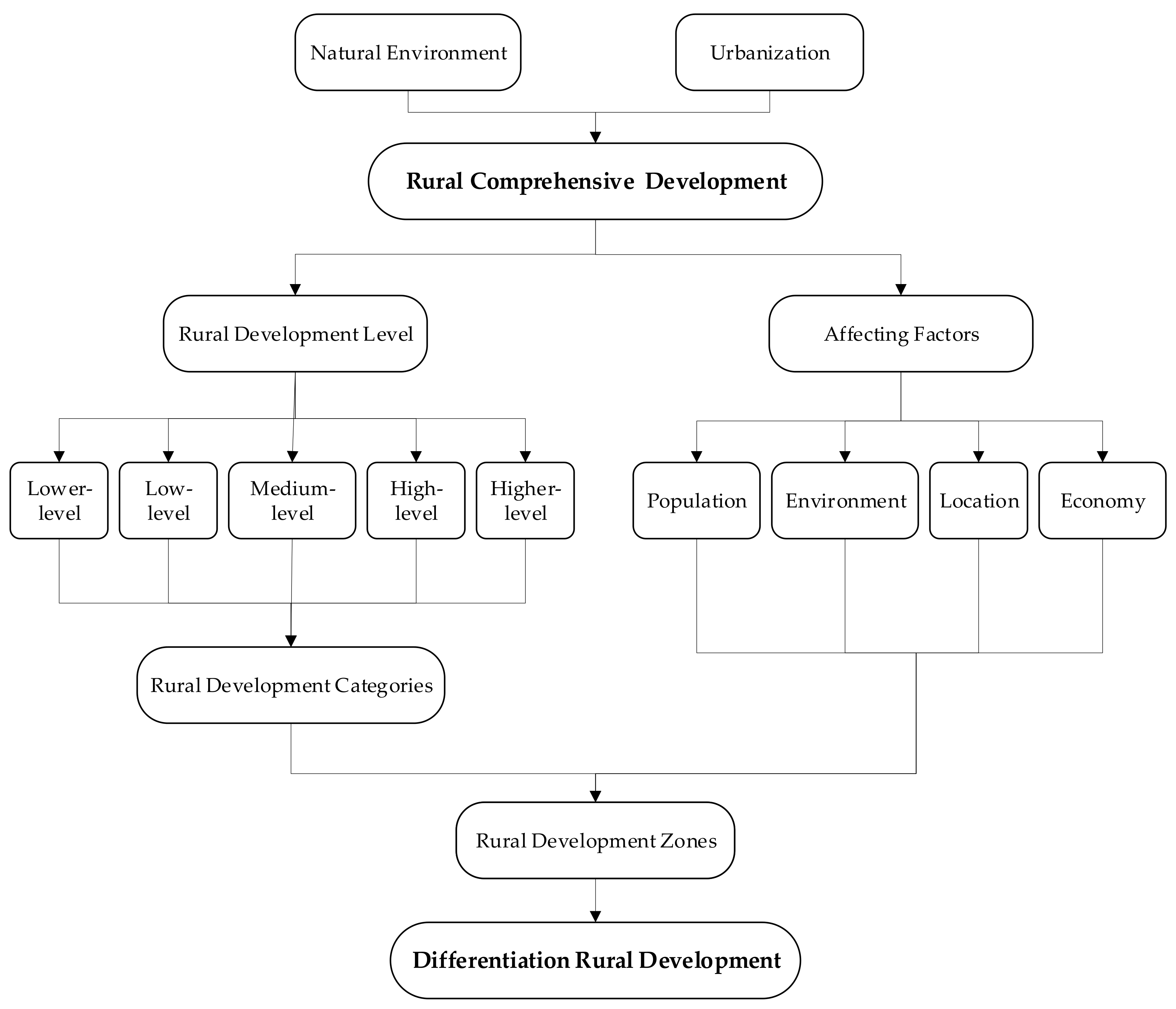
3.1. Research Framework and Methodology

3.1.1. Assessment Indicator System

The countryside is a regional complex with natural, economic, and social characteristics and with multiple functions relating to production, life, and ecology. The rural regional system is composed of rural main systems, such as humanities and the economy, and an ontology system, such as resources and the environment. It is a complex, comprehensive, dynamic, and open system that interacts in certain rural areas [67]. The development and evolution of rural regional systems are influenced by rural core systems such as economic development, social development, natural resources, and the ecological environment, and by external systems such as industrialization, urbanization, national or regional development policies, and institutional mechanisms [63,67]. At the same time, they are affected by objective factors such as the economic base and location conditions, and by subjective factors such as government, enterprises, and farmers [68]. Rural development is influenced by the rural core driving force, urban foreign aid driving force, and urban–rural interaction force [67], which determine the comprehensive measurement of rural development level from multiple dimensions. Therefore, on the basis of the comprehensiveness, scientific representativeness, and the availability of evaluation indicators, an evaluation index system of the rural comprehensive development level was constructed from the subsystems of population, environment, location, and economy (Table 2).
Three indicators—permanent population, the proportion of employees, and the proportion of employees in secondary and tertiary industries—were selected to evaluate the development capacity and potential of the rural population system. The key to rural development lies in people, especially those who live in rural areas for agricultural production [69]. They provide the human support for rural development. The rural population reflects the level of rural development and development potential to a certain extent. At the same time, for the arid areas where desert and oasis are distributed alternately, the rural population is affected by the natural environment; because of the influence of the natural environment, the rural population has a significant geographical differentiation pattern, which can better reflect the regional differences in rural areas. Labor supply is an important factor in rural development [70]. The proportion of employees reflects the age structure of the population and the status of labor resources, reflecting the capacity for rural development. The proportion of employees in secondary and tertiary industries reflects the cultural structure of the population and the awareness of multiple employment areas. The Kashgar region once was a traditional farming area, where farmers mainly focus on agricultural production activities. The people engaged in the secondary and tertiary industries are mostly returnees and immigrants with a relatively high education level, reflecting the cultural structure and population absorption in the region. Farmers who have contracted or transferred their land and gained leisure time as a result may also choose to engage in secondary and tertiary industry management activities, reflecting the diverse employment consciousness of rural farmers. The larger the permanent population, the proportion of employees and the proportion of employees in secondary and tertiary industries, the greater the development capacity and potential of the rural population.
Elevation, slope, climate suitability, and oasis area were selected as the four indicators of rural environmental conditions. The natural geographical environment, especially the topographical conditions, forms the basis for rural production and rural development [71]. We used elevation and slope indicators to characterize the topographical features. The smaller the values, the better the natural geographical environment. Climate suitability is an important manifestation of the natural adaptability of rural human settlements. It is also a prerequisite for rural agricultural production activities and production efficiency [72], reflecting the rural population’s living and production conditions. The greater the value, the better the natural environmental conditions. The proportion of oases in the arid area reflects the regional ecological environmental conditions. The higher the value, the better the ecological environment; otherwise, the more fragile the ecological environment.
Three indices, namely, the shortest distance to the county center, the shortest distance to the traffic line, and the shortest distance to the river channel were selected to comprehensively evaluate the rural location conditions (the traffic line includes roads above Grade III, and the river channel includes natural rivers and artificial canals). Location conditions are one of the main influencing factors of rural development model selection and economic activity layout. There is a strong positive correlation between comprehensive location conditions and rural development strength [71]. The distance between the county and the city center represents the urban–rural relationship and the rural economic location advantage. The urban radiation effect on rural areas has a distance attenuation effect: the closer the rural area is to the city, the more likely it is to be driven by urban radiation, and the greater the advantage of the economic location [50]. The shortest distance to the traffic line represents the rural external traffic conditions. The accessibility and convenience of the traffic line is the foundation of communication across the countryside and between urban and rural areas. The shorter the distance, the greater the advantage of the transportation location, the possibility of external communication, and the likelihood that rural development will be affected by the driving force of the city. Water resources are an important factor limiting the economic activities, agricultural production, and population capacity in arid areas. The shortest distance to the river channel reflects the degree of regional water endowment and the location conditions of rural water sources. The shorter the distance, the better the water endowment and location. The smaller the distances to the county center, to the traffic line, and to the river (drain), the better the comprehensive location conditions of the village.
Two indicators—industrial output value and per capita cultivated land—were selected to evaluate the rural economic level. Regional economic development is the background of rural economic development, which is represented by the total industrial output value. At the same time, the per capita cultivated land is used to represent the agricultural economic level and the potential of land resources. The larger the value, the higher the economic development level.

3.1.2. Rural Development Type Classification

  • Standardization Processing
In order to eliminate the influence of the index data of each subsystem index, make them comparable, and standardize the index data, we used the following formula:
Positive   indicator :   X i j , = ( X i j X min ) / ( X max X min )
Negative   indicator :   X i j , = ( X max X i j ) / ( X max X min )
where X i j , is the normalized value for the j th indicator of the i th sample, i = 1,2,…,n, and n is the sample size; X ij is the original value for the j th indicator of the i th sample; X max is the maximum value of the j th indicator; X min is the minimum value of the j th indicator.
2.
Rural Comprehensive Development
On the basis of data standardization, the rural comprehensive development index was calculated by multiplying and summing the index weights with the normalized values. The formula is as follows:
R C D = s = 1 4 i = 1 n ω s j X i s j ,
where R D is the rural comprehensive development index; ω s j is the weight of indicator s j , which was calculated by the quotient method; s j is the j th indicator of the subsystem s ; and X s i j , is the normalized value of indicator s j of sample i .

3.1.3. Geographical Type Division

Following the principles of comprehensiveness, dominance, consistency, and regionality, we comprehensively considered various population distributions, regional natural environments, economic development levels, and comprehensive geographic locations. We should grasp the similarities and differences in regional comprehensive features, so as to divide the rural areas into types of rural development. Principal component analysis was carried out in SPSS software prior to the cluster analysis; the results were imported into ArcGIS and converted into spatial data. Finally, the rural areas in the Grater Kashgar Area were divided according to their development patterns, main function area planning, comprehensive agricultural divisions, and ecological divisions. The analysis framework is shown in Figure 1.

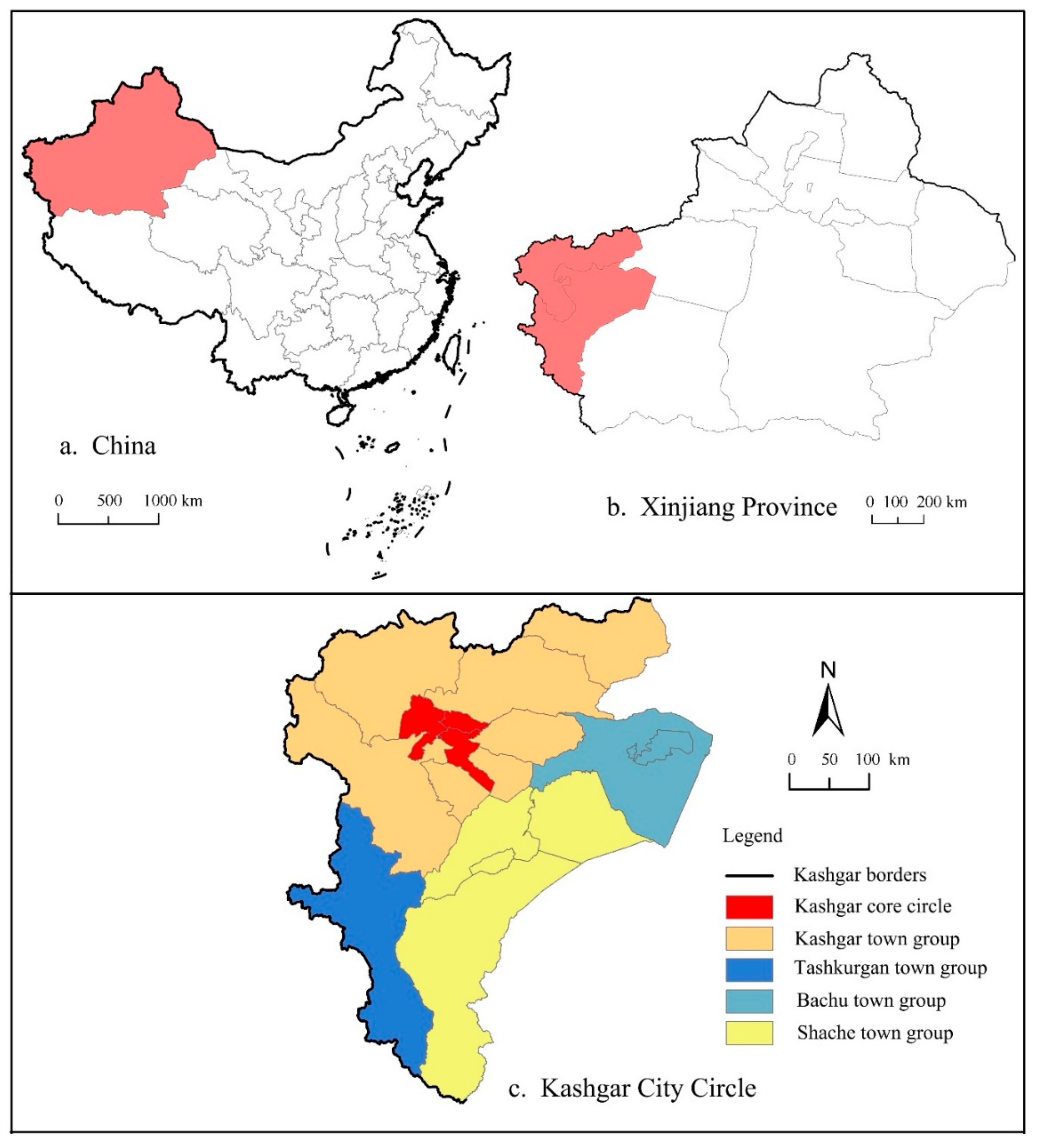
3.2. Study Area and Data Collection

The Kashgar region of northwest China has regional complexity and typicality. It is an area (Figure 2) that integrates inland arid regions, border regions, and poverty-stricken areas in northwestern China. The Kashgar region is one of China’s 14 concentrated contiguous special hardship areas and deeply poverty-stricken areas. The 12 counties (cities) under its jurisdiction are all key poverty alleviation ones; of them, ten are key poverty-stricken counties, and they contain 1222 key poverty alleviation villages. This accounts for 52.09% of the administrative villages in the district, and the number of people classified as “poor” is 1.21 million, accounting for 35% of the total rural population. In the Kashgar region, 126 mountain villages and 58 border villages have 128,000 poor people living in harsh conditions with poor infrastructure, and a low development level. The deep mountainous areas and border areas with low levels of dispersion and development have the characteristics of wide and deep poverty with many poor people. The Kashgar area provides a good geographical space for rural revitalization. Its harsh environment and poverty characteristics also determine the difficulty of rural revitalization, which has research significance.
The indicators of the population subsystem (X1-X3) and the industrial output value (X11) in the economic subsystem were the 2018 derived from China County Statistical Yearbook (township volume). The elevation (X4) and slope indicators of the environmental subsystem (X5) were determined based on the digital elevation model (DEM) data obtained from the geospatial data Cloud platform using the spatial analysis method. The climate suitability (X6) indicator data were calculated based on temperature, precipitation, and humidity data obtained from the Resource Environment Cloud Platform of the Chinese Academy of Sciences. The oasis area ratio (X7) of the environmental subsystem and the per capita arable land (X12) data of the economic subsystem were calculated from the land use data. The data of the location subsystem (X8-X10) are calculated by a spatial analysis method based on the traffic line, river and county distribution data obtained from the National Geographic Information Resources Catalogue Service System.

4. Results

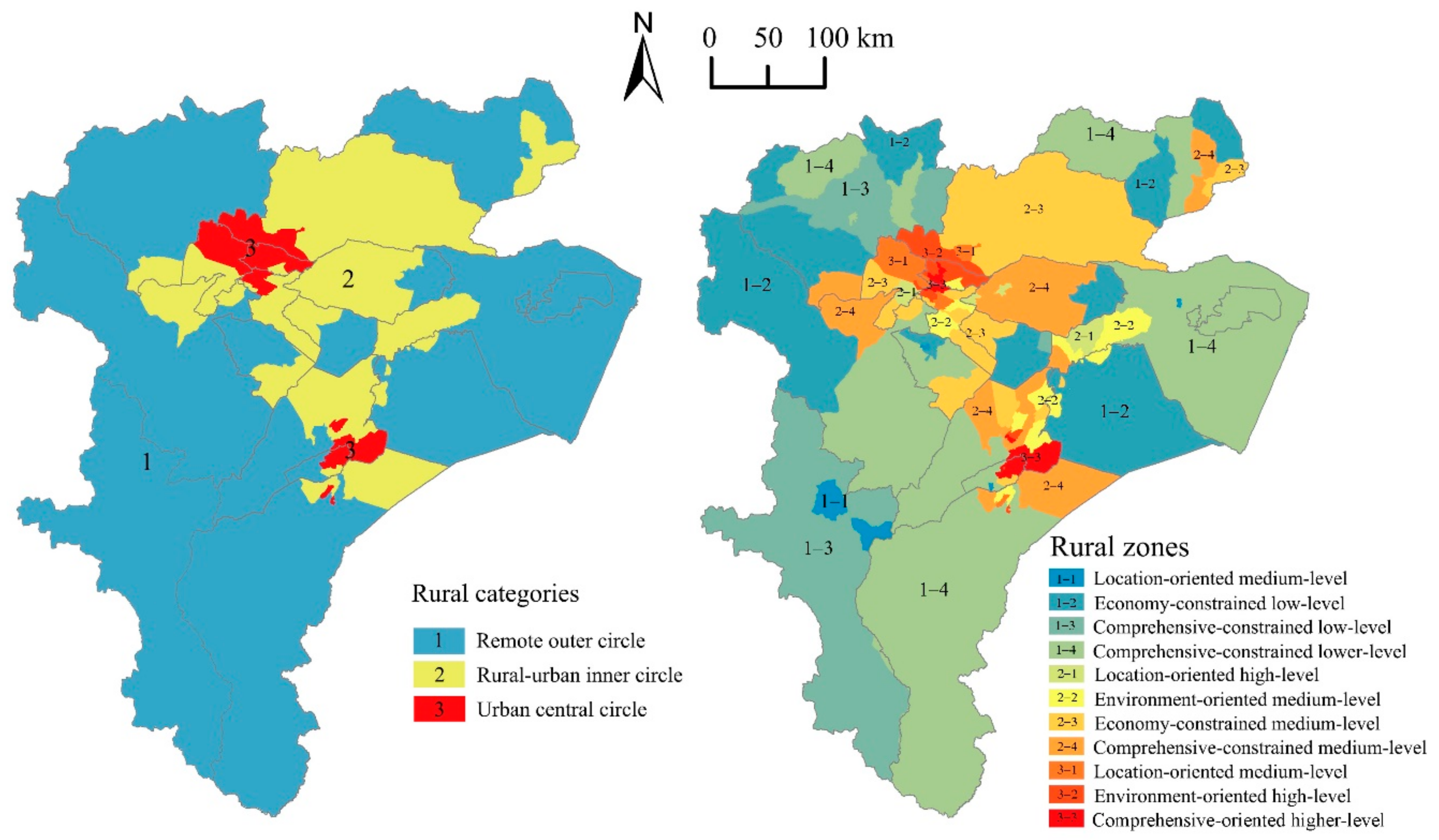
4.1. Spatial Differentiation Characteristics of the Rural Development Level

According to Equation (3), the comprehensive development levels of rural areas in the Kashgar region were calculated, and the results were normalized to obtain the final evaluation results. The natural breakpoint method (Jenks) was used to divide the rural comprehensive development levels into five levels.
The comprehensive development levels of rural areas in the Kashgar region can be divided into lower-level areas (0–0.05), low-level areas (0.05–0.11), medium-level areas (0.11–0.20), high-level areas (0.20–0.33), and higher-level areas (0.33–1) (Figure 3). There are obvious regional differences in the comprehensive development level of rural areas, which is generally manifested in the gradual decline from the inside to the outside with Kashgar-Shache as the center. Rural areas with lower, low, medium, high, and higher levels of comprehensive development accounted for 7.74%, 31.61%, 41.29%, 8.39%, and 10.97% of the total number, respectively. The number of towns with medium development level was the largest, followed by the low development level. The total proportion of the above two types of towns was close to 73%, and only about 20% of the total were at a higher development level (Table 3).
The higher-level areas are distributed in the core towns of the Kashgar town group and the Shache town group. These areas have flat terrain, superior agricultural production conditions, and better living environment, which is conducive to population agglomeration. The transportation is convenient, greatly influenced by the radiation of urban development, and rural industrialization is high.
The high-level areas are located in Kashgar town group, which is close to the periphery of higher-level areas. These areas are located in the transition zone from high mountain to flat land, with large gradient, small oasis areas, limited agricultural production, and a high proportion of employees in the secondary and tertiary industries. The villages have a certain self-development ability and a high level of comprehensive development, but its traffic location advantage is insufficient.
The medium-level areas are located in the middle of the study area, close to the periphery of the higher-and high-level areas. The small oasis area and insufficient per capita arable land in this area lead to the lack of scale advantage in agricultural production. The faraway location makes the weak influence from the town and the low development level of the secondary and tertiary industries. As a result, the rural self-development ability is weak and the external driving force is deficient, which belongs to the middle development level areas.
The low-level areas are located in the periphery of the study area. These areas are characterized by extensive mountains and deserts, fragile ecological environment, rare population, and poor location conditions. Still, rural areas lack the self-development foundation and ability, and are limited by the positive impact of cities. Therefore, rural development is restricted by both internal and external driving forces, which makes the rural poverty problem prominent.
The lower-level areas are scattered. These areas are high in altitude, steep in slope, harsh in natural environment, fragile in ecological environment, and agricultural production is dominated by alpine animal husbandry. Villages are sparsely distributed, with a small population and strong seasonal mobility and a lower level of comprehensive development.

4.2. Rural Development Types

In view of the regional differences in the pattern characteristics, influencing factors and development mode of the comprehensive development level in rural areas, this paper further discusses the regional division of the rural comprehensive development types. Based on the principal component analysis and cluster analysis, the rural areas in the Kashgar region are divided into three categories (primary areas) and 11 zones (secondary areas) (Figure 4). Different rural area types capture the distinction basic characteristics and development orientation.
According to the spatial characteristics and clustering results of rural comprehensive development level, the first level areas of rural development type were divided. Then based on the above rural comprehensive development level threshold standard, the rural development types included in every primary area are counted. For example, there are three rural development types in the urban central circle: medium-level (0.20), high-level (0.32), and higher-level (0.43). Accordingly, identifying the leading factors that affect the rural development level base on the evaluation subsystem score of the rural comprehensive development level, and take “leading factors + development level” as the criterion to name the secondary area.
The primary areas form a circle structure with Kashgar Kashi-Shache as the center, which the comprehensive rural development level gradually decreases from the inside to the outside. The basic features of each category are shown in Table 4.
The urban central circle countryside is mainly distributed in the center of the Kashgar town group and the Shache town group. There are three rural development types in this circle, i.e., medium-level area, high-level area, and higher-level area. On this basis, it can be further divided into three secondary rural zones: the location-dominated medium-level zone, the environment-oriented high-level zone, and the comprehensive-oriented higher-level zone. The basic features of each zones are shown in Table 5.
The urban–rural inner circle countryside is mainly distributed in the periphery of the urban central circle countryside. There are two rural development types in this circle, namely, medium-level area and the high-level area. On this basis, it is further divided into four secondary rural zones: the location-oriented high-level zone, the environment-oriented medium-level zone, the economy-constrained medium-level zone, and the comprehensive-constrained medium-level zone.
The remote peripheral circle countryside is mainly distributed in the periphery of the Kashgar region. There are three rural development types in this circle, namely lower-level area, low-level area, and medium-level area. On this basis, it can be further divided into four secondary rural zones: the location-oriented medium-level zones, the economy-constrained low-level zones, the comprehensive-constrained low-level zone, and the comprehensive-constrained lower-level zone.

5. Discussion and Conclusions

5.1. Discussion

Rural development is influenced by natural conditions, existing economic, social foundations, historical and cultural background, as well as geographical location and traffic conditions. In the above analyses, we concluded that the spatial differentiation characteristics of rural comprehensive development level in the Kashgar region is very obvious. The high-level areas are mainly concentrated in the center areas while the low-level areas are mainly distributed in the periphery areas. This spatial differentiation pattern can be attributed to regional differentiation of natural environmental foundations and urban radiation intensity.
It should be noted that the rural areas surrounding of the cities are very important to the cities. Many people work in cities but live in rural areas. This means that the connection between the city and the city-close countryside has been further strengthened in some aspects, and in the process of urban expansion, this city-close countryside has become an important part of the urban area. However, the impact of the city on the surrounding area decreases as the distance increase. The possibility that residents work in the city and choose to live in the countryside depends on their commuting time [38]. As Johansson et al. [73] found that the proportion of commuters dropped rapidly after more than one hour of commuting time. Although the acceptable commuting time in the Kashgar region is different from that in other countries and regions because of the differences in the traditional and social conditions, the general pattern that commuting is reduced as the distance increases is undisputed. In other words, the interaction between the city and the city-close rural will be further strengthened, while the interaction with peripheral rural areas will gradually decrease. It seems that rural recession is an inevitable process in the development of human society from agricultural economy to urban-industrial economy and further to knowledge economy.
In fact, in the urban-industrial dominated capital socioeconomic development stage, the city-close rural and the peripheral rural has significant differences in the external development environment, economic growth mode and momentum, production factors organization mode and composition. Therefore, their response pattern, degree and results to the external development disturbance also have stage characteristics [74]. Under the interaction of rural system and urban radiation, there are two completely different directions of rural development, that is, the city surrounding the countryside will rely more on the city to achieve rapid development, and eventually become a part of the metropolitan area with the arrival of the knowledge economy era; while the peripheral hinterlands will gradually decline and eventually die out. In this process, if the peripheral remote villages can continuously improve their resilient capacity to adapt to the changes of the external environment through learning and change, and then realize transformation and development, they can avoid stagnant or dying and realize new development. For example, tourism areas that exploit new resources in the form of natural and cultural amenities, or new functions such as research communities, retirement communities, entertainment communities, and local trade centers that meet the urban demands have been found in rural areas, which may eventually lead to different models and results of peripheral rural development [74].
The division of the rural development types in the Kashgar region reflects three possible results of rural development: grow, decline and vanish, which is in the industrialization development stage. The urban central circle countryside, in city-close area, which has the strongest exchange with the city. The villages in this area will rely more on the city in the current development stage and the future knowledge economy stage, so as to achieve rapid development. While the urban–rural inner circle countryside and the remote peripheral circle countryside are belonging to the peripheral areas, which have weak interaction with the city and will decline or vanish in the current development stage and the future knowledge economy stage. However, no matter in the natural environment foundation, economic development level or the interaction with cities and towns, the urban–rural inner circle countryside is better than the remote peripheral circle ones. Villages in the urban–rural inner circle area will gradually decline at this development stage. The remote peripheral circle are those villages, located in deep valleys or mountainous areas with inconvenient transportation, unstable water supply, infertile land, atrocious natural environment, frequent natural disasters, will always be developmentally fragile. Needless to say, these unsuitable living villages need to be relocated under the development concept of rural sustainability and ecological environment protection [9]. Therefore, the exogenous rural development force, such as government’s responding development strategy, will push inhabitants in the remote peripheral circle countryside move to the nearby towns or villages in urban–rural inner circle, where there are better transportation, land, and public services. In other words, the remote peripheral circle countryside in the Kashgar region will “given over to nature.” It is a rapid vanish caused by the peasant migration, which is different from what Westlund and Lefebvre demonstrate in the post-urban world. Therefore, we declare that in this kind of areas with atrocious natural conditions, some villages may vanish rapidly, which complements the discussion on the rural development types in the industrialization stage.
In this paper, the classification of rural development types is significantly different from the previous ones, which focus on urban–rural location, rural production and rural functions, which can further deepen the understanding of urban–rural relations. These classifications can further deepen the understanding of urban–rural relations. However, the Great Kashgar Region is different from other countries and regions in terms of natural conditions and urbanization level, the former classification of rural development types is not suitable for the Kashgar region. Therefore, based on the comprehensive consideration of the rural development level and its dominant factors, we have carried out a comprehensive classification of the rural development types, which can clear the rural development direction and optimize the rural development path. Furthermore, it should be pointed out that changes in natural environmental factors and socio-economic factors affecting rural development, even the flow between regions, can cause changes in the rural development type. Therefore, the types of rural development in this paper are the ones under the current development stage. With the time passage by, the rural development types may change. As for which type will be changed in the future, and when will it start to change, it depends on the trend of these factors.

5.2. Conclusions

Different rural development types are shaped by the interaction between material and immaterial elements that affect rural production and lifestyles [41]. According to the main factors influencing the rural development ability and long-term development potential, the assessment indicator system of rural comprehensive development (RCD), including four dimensions of rural population, environment, location, and economy, was established to assess the comprehensive development level. Then, using the principal component analysis method and the cluster analysis method, we divided the rural areas in the Kashgar region into three categories and 11 zones based on the comprehensive evaluation results.
Our research results show that the high-level rural development areas are mainly concentrated in the center of the region, while the low-level areas are mainly distributed in the periphery, with significant spatial differentiation characteristics. We have divided the rural development types into three categories (primary areas) and 11 zones (secondary areas). These three categories form a circle structure with Kashgar-Shache as the center, and its comprehensive rural development level gradually decreases from the inside to the outside. With the development of economy and society and the enhancement of the interaction between cities and surrounding villages, the core-periphery differentiation pattern will become more obvious. To some extent, the primary areas division can accurately reflect the rural development basis and status quo, and the secondary zones division can reflect the dominant factors of rural development. It has important guiding significance for periphery rural to adjust the internal components function and structure to respond to the external development changes, so as to promote rural transformation and avoid recession.
In the process of social development from agricultural period to urban-industrial economy and to knowledge economy, tremendous changes have taken place in the relationship between urban and rural areas. In the interaction with cities, the rural external development environment has also changed, facing more severe challenges, and rural recession seems inevitable. It has been considered that the rural areas began to show two different development trends in the industrialization stage. The rural areas around the city have achieved growth because of the better interaction with cities. While the periphery villages are increasingly not needed by the cities, and began to decline due to the worse interaction with cities. Even worse, the former will become a part of the metropolitan region, while the latter will decline and vanish in knowledge economy era. That is to say, the countryside will no longer exist.
However, while this negative prognosis for periphery rural area is global, then affected by the varying development processes of industrialization, urbanization, globalization, and informatization, the rural areas in developed countries and regions are not the same as those in developing countries and regions, in terms of their development stages and external environmental challenges. We cannot help thinking about whether there are other types or results of rural development. Scholars have cited many examples to show that the peripheral rural can gain new development by adjusting their internal function and structure to adapt to the changes in urban demand. Through the case study of the Great Kashgar Area, we pointed out that in the urban industrialization stage, in addition to growth and decline, there is another rural development type: vanish. This kind of vanish is the rapid migration of all the residents to the around areas with better natural environment and economic under the management of the government or resident’s spontaneous migration.
With the transformation of human society and the change of urban–rural relationship in its mode and content, the external economy, society, and changing environment has put pressures on the rural areas. These pressures are so great, and the ability of rural areas to counteract them is so limited. Therefore, according to different rural development types, it is necessary to take measures to strengthen rural areas to cope with external environmental challenges. At present, the purpose of the Rural Revitalization Strategy in China is to promote the interaction between rural areas and urban areas, then to achieve a balanced state of rural functions, elements composition, and system operation, and finally to promote the transformation of rural development and to achieve urban–rural integration.
As a special geographical location, Great Kashgar Area is the west gate of China and the core area of the Silk Road Economic Belt. From the perspective of economic development level, this region is one of the most underdeveloped areas in China, with low rural development level and prominent urban–rural contradictions. According to the latest Rural Revitalization and Development Plan of Kashgar in 2018, it is necessary to classify rural areas and promote rural development orderly. In order to achieve these goals, local governments should adopt corresponding measures to promote rural transformation, improve comprehensive rural development level, achieve urban–rural integration, and maintain social stability, according to the characteristics of rural development types and dominant factors.
Specifically, first of all, for the urban central circle area, that is, the growing rural around the cities, the local government should promote ruralization together with urbanization. City and village residents should enjoy equal rights of resources, public services, and social welfare. Improve rural development level from rural location conditions and internal and external environment, enhance endogenous development force, and promote sustainable rural growth. Second, for the urban–rural inner area, that is, the declining rural, government needs to take measures to revitalize the countryside. One is to discover local resources, special agricultural products and landscapes in these areas and develop them into industries to help local economic prosperity. Another is to develop rural social capital, such as social network, social participation and trust, to attract business. Third, for the remote outer circle villages, that is, the dying rural, government should provide suggestions and funds in the process of migration, and their willingness to move to where to live should be respected. At the same time, the local government should guarantee these resettlers housing, education, employment, medical care, and entrepreneurship services. Finally, no matter what rural type it is, a scientific plan is necessary to guide the rural revitalization. Researchers must understand the factors that lead to the rural decline and rural response to urbanization and the natural environment change. Ministries, research institutes, and enterprises should promote multidisciplinary research in rural planning, management and engineering, and monitor rural development.

Author Contributions

Data curation, J.L. (Jiangang Li); Funding acquisition, J.L. (Jun Lei); Writing—original draft, J.L. (Jinping Lin); Writing—review and editing, Z.Y. All authors read and approved the final manuscript.

Funding

The current work is the Strategic Priority Research Program of Chinese Academy of Sciences, Pan-Third Pole Environment Study for a Green Silk Road (Pan-TPE) (NO: XDA20040400).

Conflicts of Interest

The authors declare no conflict of interest.

References

  1. Mayer, H.; Habersetzer, A.; Meili, R. Rural-urban linkages and sustainable regional development: The role of entrepreneurs in linking peripheries and centers. Sustainability 2016, 8, 745. [Google Scholar] [CrossRef]
  2. Liu, Y.S.; Lu, S.S.; Chen, Y.F. Spatio-temporal change of urban-rural equalized development patterns in China and its driving factors. J. Rural Stud. 2013, 32, 320–330. [Google Scholar] [CrossRef]
  3. Roberts, P. Wealth from waste: Local and regional economic development and the environment. Geogr. J. 2004, 170, 126–134. [Google Scholar] [CrossRef]
  4. McGee, T.G. Managing the rural-urban transformation in East Asia in the 21st century. Sustain. Sci. 2008, 3, 155–167. [Google Scholar] [CrossRef]
  5. Liu, C.F.; Yu, B.; Zhu, Y.; Liu, L.C.; Li, P.J. Measurement of rural residents’ mobility in Western China: A case study of Qingyang, Gansu province. Sustainability 2019, 11, 2492. [Google Scholar] [CrossRef]
  6. Shi, M.; Xie, Y.; Cao, Q. Spatiotemporal changes in rural settlement land and rural population in the middle basin of the Heihe River, China. Sustainability 2016, 8, 614. [Google Scholar] [CrossRef]
  7. Zeng, Z. Changes to the global economic pattern and modernization prospects of development countries. In Global Modernization Review: New Discoveries and Theories Revisited; WSPC: Singapore, 2015. [Google Scholar] [CrossRef]
  8. Li, Y.H.; Su, B.Z.; Liu, Y.S. Realizing targeted poverty alleviation in China people’s voices, implementation challenges and policy implications. China Agric. Econ. Rev. 2016, 8, 443–454. [Google Scholar] [CrossRef]
  9. Liu, Y.S.; Li, Y.H. Revitalize the world’s countryside. Nature 2017, 548, 275–277. [Google Scholar] [CrossRef]
  10. Zhang, Y.N.; Long, H.L.; MA, L.; Tu, S.S.; Chen, K.Q. Research progress of urban-rural relations and its implications for rural revitalization. Geogr. Res. 2019, 38, 578–594. (In Chinese) [Google Scholar] [CrossRef]
  11. Xue, Q.; Sun, H.A. The successful experience of urban and rural integration in western countries. Agric. Econ. 2014, 61–63. (In Chinese) [Google Scholar] [CrossRef]
  12. Huang, Z.X. Garden cities of tomorrow and rural land system reform in China. J. Anhui Agric. Univ. 2009, 6, 19–21. (In Chinese) [Google Scholar] [CrossRef]
  13. North, D.; Smallbone, D. The innovativeness and growth of rural SMEs during the 1990s. Reg. Stud. 2000, 34, 145–157. [Google Scholar] [CrossRef]
  14. Clark, G.; Cummins, N. Surnames and social mobility in England, 1170-2012. Hum. Nat. 2014, 25, 517–537. [Google Scholar] [CrossRef]
  15. Tang, S.S. Rural policy and enlightenment in the process of rapid urbanization in France. Issue Agric. Econ. 2012, 33, 104–109. (In Chinese) [Google Scholar] [CrossRef]
  16. Farrigan, T.L. Rural development: Principles and practice. Reg. Stud. 2004, 38, 728. [Google Scholar]
  17. Halfacree, K. Contesting rurality: Politics in the British countryside. J. Rural Stud. 2008, 24, 478. [Google Scholar] [CrossRef]
  18. Cole, M. New labour’s countryside: Rural policy in Britain since 1997. Political Stud. Rev. 2010, 8, 267–268. [Google Scholar]
  19. Tian, L.; Yao, Z. From state-dominant to bottom-up redevelopment: Can institutional change facilitate urban and rural redevelopment in China. Cities 2018, 76, 72–83. [Google Scholar] [CrossRef]
  20. He, R.W. Urban-rural integration and rural revitalization: Theory, mechanism and implementation. Geogr. Res. 2018, 37, 2127–2140. (In Chinese) [Google Scholar] [CrossRef]
  21. Liu, Y.S. Introduction to land use and rural sustainability in China. Land Use Pol. 2018, 74, 1–4. [Google Scholar] [CrossRef]
  22. Liu, Y.S.; Fang, F.; Li, Y.H. Key issues of land use in China and implications for policy making. Land Use Policy 2014, 40, 6–12. [Google Scholar] [CrossRef]
  23. Zhou, Y.; Guo, L.Y.; Liu, Y.S. Land consolidation boosting poverty alleviation in China: Theory and practice. Land Use Policy 2019, 82, 339–348. [Google Scholar] [CrossRef]
  24. Chen, C.; Gao, J.L.; Chen, J.L. Institutional changes, land use dynamics, and the transition of rural settlements in suburban China: A case study of Huishan District in Wuxi city. Habitat Int. 2017, 70, 24–33. [Google Scholar] [CrossRef]
  25. Tian, Y.S.; Liu, Y.F.; Kong, X.S. Restructuring rural settlements based on mutualism at a patch scale: A case study of Huangpi District, central China. Appl. Geogr. 2018, 92, 74–84. [Google Scholar] [CrossRef]
  26. Lin, Y.L.; De Meulder, B.; Cai, X.X.; Hu, H.D.; Lai, Y.N. Linking social housing provision for rural migrants with the redevelopment of ‘villages in the city’: A case study of Beijing. Cities 2014, 40, 111–119. [Google Scholar] [CrossRef]
  27. Liu, R.; Wong, T.C. Urban village redevelopment in Beijing: The state-dominated formalization of informal housing. Cities 2018, 72, 160–172. [Google Scholar] [CrossRef]
  28. Guo, Y.; Xiao, Y.; Yuan, Q.F. The redevelopment of peri-urban villages in the context of path-dependent land institution change and its impact on Chinese inclusive urbanization: The case of Nanhai, China. Cities 2017, 60, 466–475. [Google Scholar] [CrossRef]
  29. Wu, X.Y.; Qi, X.H.; Yang, S.; Ye, C.; Sun, B. Research on the intergenerational transmission of poverty in rural China based on sustainable livelihood analysis framework: A case study of six poverty-stricken counties. Sustainability 2019, 11, 2341. [Google Scholar] [CrossRef]
  30. Lipton, M. Why Poor People Stay Poor: Urban Bias in World Development; Harvard University: Cambridge, MA, USA, 1977; p. 467. [Google Scholar]
  31. Friedmann, J. Four theses in the study of China’s urbanization. Int. J. Urban Reg. Res. 2006, 30, 440–451. [Google Scholar] [CrossRef]
  32. Preston, D.A. Rural-urban and inter-settlement interaction: Theory and analytical structure. Area 1975, 7, 171–174. [Google Scholar] [CrossRef]
  33. Wang, H.; Chen, L. Review on the development theories of rural and urban areas in west. Econ. Geogr. 2006, 26, 463–468. (In Chinese) [Google Scholar] [CrossRef]
  34. Douglass, M. A regional network strategy for reciprocal rural-urban linkages: An agenda for policy research with reference to Indonesia. Third World Plan. Rev. 1998, 20, 1. [Google Scholar] [CrossRef]
  35. Sui, D.Z.; Zeng, H. Modeling the dynamics of landscape structure in Asia’s emerging desakota regions: A case study in Shenzhen. Landsc. Urban Plan. 2001, 53, 37–52. [Google Scholar] [CrossRef]
  36. Skeldon, R. Rural-to-urban migration and its implications for poverty alleviation. Asia Pac. Popul. J. 1997, 12, 3–16. [Google Scholar] [CrossRef] [Green Version]
  37. Andersson, K. Beyond the rural urban divide. Environ. Urban. 2012, 10, 3–4. [Google Scholar] [CrossRef]
  38. Westlund, H. In Urban-rural relations in the post-urban world. In The Post-Urban World: Emergent Transformation of Cities and Regions in the Innovative Global Economy; Haas, T., Westlund, H., Eds.; Routledge: London, UK, 2018; pp. 70–81. [Google Scholar]
  39. Long, H.L.; Zou, J.; Pykett, J.; Li, Y. Analysis of rural transformation development in China since the turn of the new millennium. Appl. Geogr. 2011, 31, 1094–1105. [Google Scholar] [CrossRef]
  40. Long, H.L.; Hellig, G.K.; Li, X.B.; Zhang, M. Socio-economic development and land-use change: Analysis of rural housing land transition in the Transect of the Yangtse River, China. Land Use Policy 2007, 24, 141–153. [Google Scholar] [CrossRef]
  41. Long, H.L.; Zou, J.; Liu, Y.S. Differentiation of rural development driven by industrialization and urbanization in eastern coastal China. Habitat Int. 2009, 33, 454–462. [Google Scholar] [CrossRef]
  42. Jiang, G.H.; Ma, W.Q.; Zhou, D.Y.; Zhao, Q.L.; Zhang, R.J. Agglomeration or dispersion? Industrial land-use pattern and its impacts in rural areas from China’s township and village enterprises perspective. J. Clean. Prod. 2017, 159, 207–219. [Google Scholar] [CrossRef]
  43. Zheng, J.H.; Liu, X.X.; Bigsten, A. Ownership structure and determinants of technical efficiency: An application of data envelopment analysis to Chinese enterprises (1986-1990). J. Comp. Econ. 1998, 26, 465–484. [Google Scholar] [CrossRef]
  44. Cai, Y.L.; Smit, B. Sustainability in Chinese agriculture-challenge and hope. Agric. Ecosyst. Environ. 1994, 49, 279–288. [Google Scholar] [CrossRef]
  45. Liu, Y.S.; Gao, J.; Yang, Y.F. A holistic approach towards assessment of severity of land degradation along the Great Wall in Northern Shaanxi Province, China. Environ. Monit. Assess. 2003, 82, 187–202. [Google Scholar] [CrossRef] [PubMed]
  46. Xu, W.; Tan, K.C. Impact of reform and economic restructuring on rural systems in China: A case study of Yuhang, Zhejiang. J. Rural Stud. 2002, 18, 65–81. [Google Scholar] [CrossRef]
  47. Yang, H.; Li, X.B. Cultivated land and food supply in China. Land Use Policy 2000, 17, 73–88. [Google Scholar] [CrossRef]
  48. Cloke, P.J. Whither rural studies? J. Rural Stud. 1985, 1, 1–9. [Google Scholar] [CrossRef]
  49. Cloke, P.; Goodwin, M.; Milbourne, P.; Thomas, C. Deprivation, poverty and marginalization in rural lifestyles in England and Wales. J. Rural Stud. 1995, 11, 351–365. [Google Scholar] [CrossRef]
  50. Bryant, C.R.; McLellan, A.G.; Russwurm, L.H. The City’s Countryside: Land and its Management in the Rural-Urban Fringe; Longman: New York, NY, USA, 1982; pp. 11–15. [Google Scholar]
  51. Kato, Y.; Yokohari, M.; Brown, R.D. Integration and visualization of the ecological value of rural landscapes in maintaining the physical environment of Japan. Landsc. Urban Plan. 1997, 39, 69–82. [Google Scholar] [CrossRef]
  52. Hu, H.Y. Agricultural regions of China. Acta Geogr. Sin. 1936, 3, 1–17. (In Chinese) [Google Scholar] [CrossRef]
  53. Zhou, L.S.; She, Z.X. Agricutural geography and land utilization. Acta Geogr. Sin. 1990, 45, 146–153. (In Chinese) [Google Scholar] [CrossRef]
  54. Liu, Y.S.; Zhang, Z.W.; Wang, J.Y. Regional differentiation and comprehensive regionalization scheme of modern agriculture in China. Acta Geogr. Sin. 2018, 73, 203–218. (In Chinese) [Google Scholar] [CrossRef]
  55. Unger, J.; Chan, A. Inheritors of the boom: Private enterprise and the role of local government in a rural south China township. China J. 1999, 42, 45–74. [Google Scholar] [CrossRef]
  56. Li, X.J.; Yang, H.M. The change of rural settlements and their future development patterns. Econ. Geogr. 2017, 37, 1–8. (In Chinese) [Google Scholar] [CrossRef]
  57. Shan, Y.B.; Ma, X.D.; Qiu, F.D. Distribution patterns characteristics and type classification of the rural settlements in central Jiangsu province. Sci. Geogr. Sin. 2012, 32, 1340–1347. (In Chinese) [Google Scholar] [CrossRef]
  58. Tan, X.L.; Liu, Z.; He, Y.H.; Tan, J.; Zhang, Y.S.; Zhou, G.H. Regional differentiation and type division of rural settlements to South of Yangtse River: A case study of Changsha. Geogr. Res. 2015, 34, 2144–2154. (In Chinese) [Google Scholar] [CrossRef]
  59. Cloke, P.J. An index of rurality for England and Wales. Reg. Stud. 1977, 11, 31–46. [Google Scholar] [CrossRef]
  60. Harrington, V.; O’Donoghue, D. Rurality in England and Wales 1991: A replication and extension of the 1981 Rurality Index. Sociol. Rural. 1998, 38, 178. [Google Scholar] [CrossRef]
  61. Bański, J.; Mazur, M. Classification of rural areas in Poland as an instrument of territorial policy. Land Use Policy 2016, 54, 1–17. [Google Scholar] [CrossRef]
  62. Sharma, H.R. Distribution of landholdings in rural India, 1953–1954 to 1981-82: Implications for Land Reforms. Econ. Political Wkly. 1994, 29, A117–A128. [Google Scholar] [CrossRef]
  63. Zhou, Y.; Guo, Y.Z.; Liu, Y.S. Areal types and their development paths in rural China. Geogr. Res. 2019, 38, 467–481. (In Chinese) [Google Scholar] [CrossRef]
  64. Wen, Q.; Zheng, D.Y. Identification and revitalization of rural poverty-stricken areas in northwest China. Geogr. Res. 2019, 38, 509–521. (In Chinese) [Google Scholar] [CrossRef]
  65. Li, L.T.; Yang, Y.Y.; Jiang, N. Mode of rural revitalization and its approaches in Beijing-Tianjin-Hebei metropolitan area: A case study of Jinghai District in Tianjin. Geogr. Res. 2019, 38, 496–508. (In Chinese) [Google Scholar] [CrossRef]
  66. Liu, H. Changing regional rural inequality in China 1980-2002. Area 2006, 38, 377–389. [Google Scholar] [CrossRef]
  67. Zhang, F.G.; Liu, Y.S. Dynamic mechanism and models of regional rural development in China. Acta Geogr. Sin. 2008, 63, 115–122. (In Chinese) [Google Scholar] [CrossRef]
  68. Long, H.L.; Liu, Y.S. Rural restructuring in China. J. Rural Stud. 2016, 47, 387–391. [Google Scholar] [CrossRef]
  69. Guo, Y.Z.; Zhou, Y.; Han, Y. Population aging in rural China: Spatial-temporal pattern and countermeasures for rural revitalization. Geogr. Res. 2019, 38, 667–683. (In Chinese) [Google Scholar] [CrossRef]
  70. Liao, L.W.; Gao, X.L. Progress and prospect of research on the impact of population aging on rural development. Prog. Geogr. 2018, 37, 617–626. (In Chinese) [Google Scholar] [CrossRef]
  71. Yang, R.; Xu, Q.; Xu, X.; Chen, Y. Rural settlement spatial patterns and effects: Road traffic accessibility and geographic factors in Guangdong Province, China. J. Geogr. Sci. 2019, 29, 213–230. [Google Scholar] [CrossRef] [Green Version]
  72. Li, J.; Wu, Y.D.; Zhang, L.; Chen, C.Y. The suitability evaluation of social and economic factors on the location of rural settlement: Take Erhai Rim Region of Yunnan for example. Econ. Geogr. 2016, 36, 195–201. (In Chinese) [Google Scholar] [CrossRef]
  73. Johansson, B.; Klaesson, J.; Olsson, M. Time distances and labor market integration. Pap. Reg. Sci. 2002, 81, 305–327. [Google Scholar] [CrossRef]
  74. Li, Y.H.; Westlund, H.; Liu, Y.S. Why some rural areas decline while some others not: An overview of rural evolution in the world. J. Rural Stud. 2019, 68, 135–143. (In Chinese) [Google Scholar] [CrossRef]
Figure 1. Analysis framework.
Sustainability 11 06859 g001
Figure 2. Location of the Kashgar region in China (a); Xinjiang province (b); and the town group of Kashgar (c).
Sustainability 11 06859 g002
Figure 3. The distribution of rural comprehensive development level in the Kashgar region.
Sustainability 11 06859 g003
Figure 4. Regionalization of the types of rural development in Kashgar region.
Sustainability 11 06859 g004
Table 1. Urban–rural relations and rural development in China since 1949.
TimeUrban–Rural Relationship Economic Development ModelRural Transformation StageMain CharacteristicsUrban–Rural Income Ratio
1949–1978Urban–rural separationHeavy industry- oriented; agriculture supports priority industrial development1949–1953Land reform revived farmers’ enthusiasm for production
1954–1958Scissors of industrial and agricultural sectors; dual urban–rural economic system2.09
1959–1978Natural disasters occurred frequently, large-scale migration between urban and rural areas forced by political factors2.23
1978–2003Urban–rural disparityCentering on city economic construction1979–1983The household contract responsibility system promoted the vitality of rural development; urban–rural coordination2.24
1984–1996Township enterprises promoted the transfer of agricultural surplus labor and agricultural modernization; urban–rural unbalancing began2.35
1997–2003Resource elements flow to cities; urban–rural unbalanced worse2.81
Since 2003Urban–rural coordinated trendIndustry supporting agriculture; urban supporting villages2004–2005“Urban–rural Balanced Development”3.22
2006–2012“New Socialist Countryside Construction”; cancelled the agricultural tax in 20063.25
2013–2017New-Type Urbanization”;“Beautiful Countryside”;“Precise Poverty Alleviation”2.79
Since 2018“Rural Revitalization”2.69
Table 2. Evaluation index system of the rural comprehensive development level.
Evaluation SystemEvaluation IndexIndicator Description (Unit)Weight
PopulationPermanent resident (X1)Frequently living at home or at home for more than 6 months (person)0.046
Proportion of employees (X2)Regional employment population-/-regional total population (%)0.060
Proportion of employees in secondary and tertiary industries (X3)Secondary and tertiary industries employees-/-total employees (%)0.008
EnvironmentElevation (X4)Regional average elevation (m)0.005
Slope (X5)Regional average slope (°)0.093
Climate suitability (X6)Temperature-humidity index0.008
Oasis area (X7)Regional oasis area-/-total area (%)0.138
LocationShortest distance to the county center (X8)The average nearest neighbor distance from villages to the county center (m)0.137
Shortest distance to the traffic line (X9)The average nearest neighbor distance from villages to the traffic line (m)0.134
Shortest distance to a river (X10)The average nearest neighbor distance from villages to any river (m)0.100
Economicindustrial output value (X11)The total amount of industrial products produced by regional industrial enterprises (yuan)0.129
per capita cultivated land (X12)Area of cultivated land/total population of the area (acres/person)0.141
Table 3. Quantity and area of different levels of towns.
Hierarchical PartitionNumber of TownsProportion (%)Area (ha)Proportion (%)
Lower-level areas127.742,792,86515.39
Low-level areas4931.6110694410.1258.91
Medium-level areas6441.293,871,32921.33
High-level areas138.39400233.702.20
Higher-level areas1710.97393691.802.17
Table 4. The basic features of rural development types.
CategoryProportion of Town(%)Comprehensive Development LevelPopulation SubsystemEnvironment SubsystemLocation SubsystemEconomy Subsystem
Urban central circle countryside16.770.350.260.830.670.17
Rural–urban inner circle countryside39.350.180.120.730.730.05
Remote peripheral circle countryside43.880.090.080.430.570.02
Kashgar region1000.210.150.660.650.08
Table 5. The basic features of rural development zones.
CategoryZoneComprehensive Development LevelPopulation SubsystemEnvironment SubsystemLocation SubsystemEconomy Subsystem
Urban central circle country-sideLocation- oriented medium-level zone0.200.190.620.840.12
Environment- oriented high-level zone0.320.280.800.550.15
Comprehensive higher-level zone0.430.270.880.710.23
Rural-urban inner circle country-sideLocation-oriented high-level zone0.330.250.540.670.29
Environment-oriented medium-level zone0.180.120.890.690.06
Economy-constrained medium-level zone0.150.110.730.690.02
Comprehensive-constrained medium-level zone0.170.130.550.680.02
Remote peripheral circle country-sideLocation-oriented medium-level zone0.160.130.560.730.04
Economy-constrained low-level zone0.080.030.520.690.01
Comprehensive-constrained low-level zone0.080.070.400.620.02
Comprehensive-constrained lower-level zone0.030.020.290.650.01
Note: The numerical characteristics of each subzone do not take into account the missing values. The comprehensive development level and the values of each subsystem are standardized values, so the comprehensive development level is not equal to the sum of the subsystems.

