1. Introduction
The system of stepped terraces of the Tormes River is the most frequent in the rivers of the Iberian Peninsula, with numerous examples noted: Pisuerga and Arlanzón-Duero Rivers, Arlanzón-Duero River, Tagus River, Duero River, Ebro River, Lozoya-Tajo Rivers, and Tagus River, among many others.
A synthetic scheme (maintaining the heights to scale) of the terrace levels of the Tormes River, in the sub-basin of Salamanca, where the heights relative to the thalweg have been indicated and as a result, the heights of the different escarpments between terraces have been drawn up successive. From the observation of these profiles, it is appreciated that there are a series of more significant escarpments, and that they are maintained in the three selected rivers. The reason for the selection of Arlanzón River (Duero Basin) and Tajo River (Tajo Basin), is that the first one has been mapped with several field scampies since the year 1983, and subsequent chronological studies of the terraces with sampling were carried out paleomagnetic and dating by ESR TL and OSL, being able to attribute to these escarpments a more precise chronology when determining the boundaries between the lower, middle, and upper Pleistocene and Holocene.
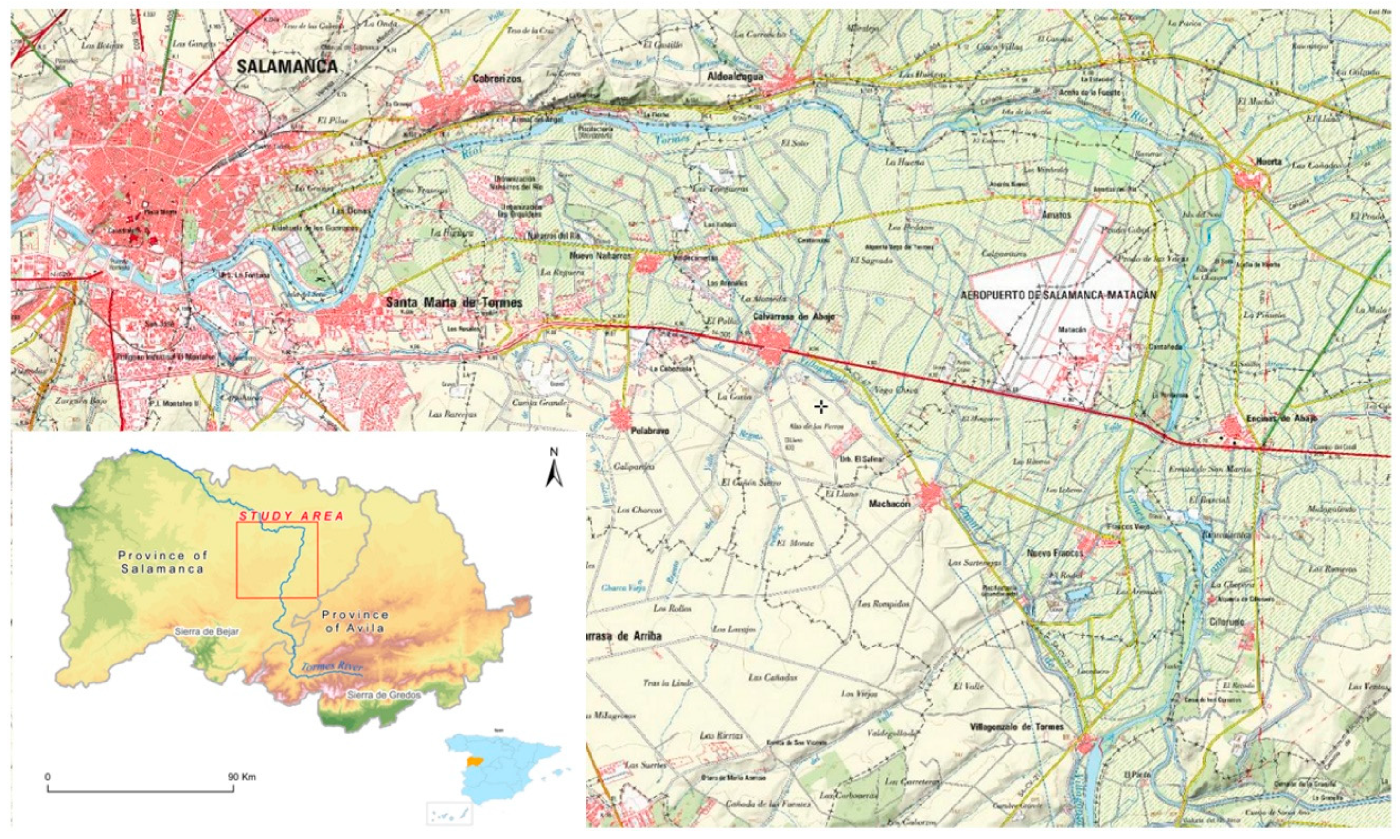
The second profile selected, Tajo River (Tajo Basin), downstream of Toledo, has been due to the fact that this sequence has numerous deposits of fauna (Macro and microfauna.), and lithic industry, which also allows the dating of terraces and their correlation; as an example, the level of +75 m is clearly located in the lower Pleistocene (presence of Equus stenonis) and that of +60m in the middle Pleistocene (southern Mammutus), so this type of correlation between escarpments can be used for related. The Tormes River belongs to the Duero River network and is located in the central-western basin of the Iberian Peninsula. This is the largest basin in the entire Iberian Peninsula, and it is called the Duero Basin. It is located in the province of Salamanca. The Tormes River runs for 80 km along a series of Cenozoic materials and through a Paleozoic basement, constituted primarily of granitic and metamorphic materials. The area is characterized by little sharp reliefs with flat and elevated surfaces and staggered plains in its central part. It is surrounded by a peripheral mountainous border with heights between 600 and 800 m. The study area occupies an area of 3200 km
2 in the Northeast part of the Province of Salamanca (
Figure 1)
The objective of this work was the realization of a detailed geomorphological cartography that allows different morphologies to be identified, and establishes the succession of depositional terraces of the Tormes River to determine the relationships among the different terraces and the time periods in which they were deposited [
1,
2,
3,
4]. From longitudinal and cross-sectional profiles, the different terraces of the same basin (Duero Basin) and similarly behaving basins (Tagus Basin) were altimetrically correlated. With these data, the incision and displacement rates of the Tormes River in the Salamanca sub-account were calculated by correlating them with the terraced sequences of the Arlanza River (Duero Basin) and the Tagus River (south of Toledo). Different three-dimensional geological models of the different stages of the Quaternary (Lower Pleistocene, Middle Pleistocene, Upper Pleistocene, and Holocene) were generated by analyzing the paleogeographic evolution of this sub-basin.
1.1. Geological Context
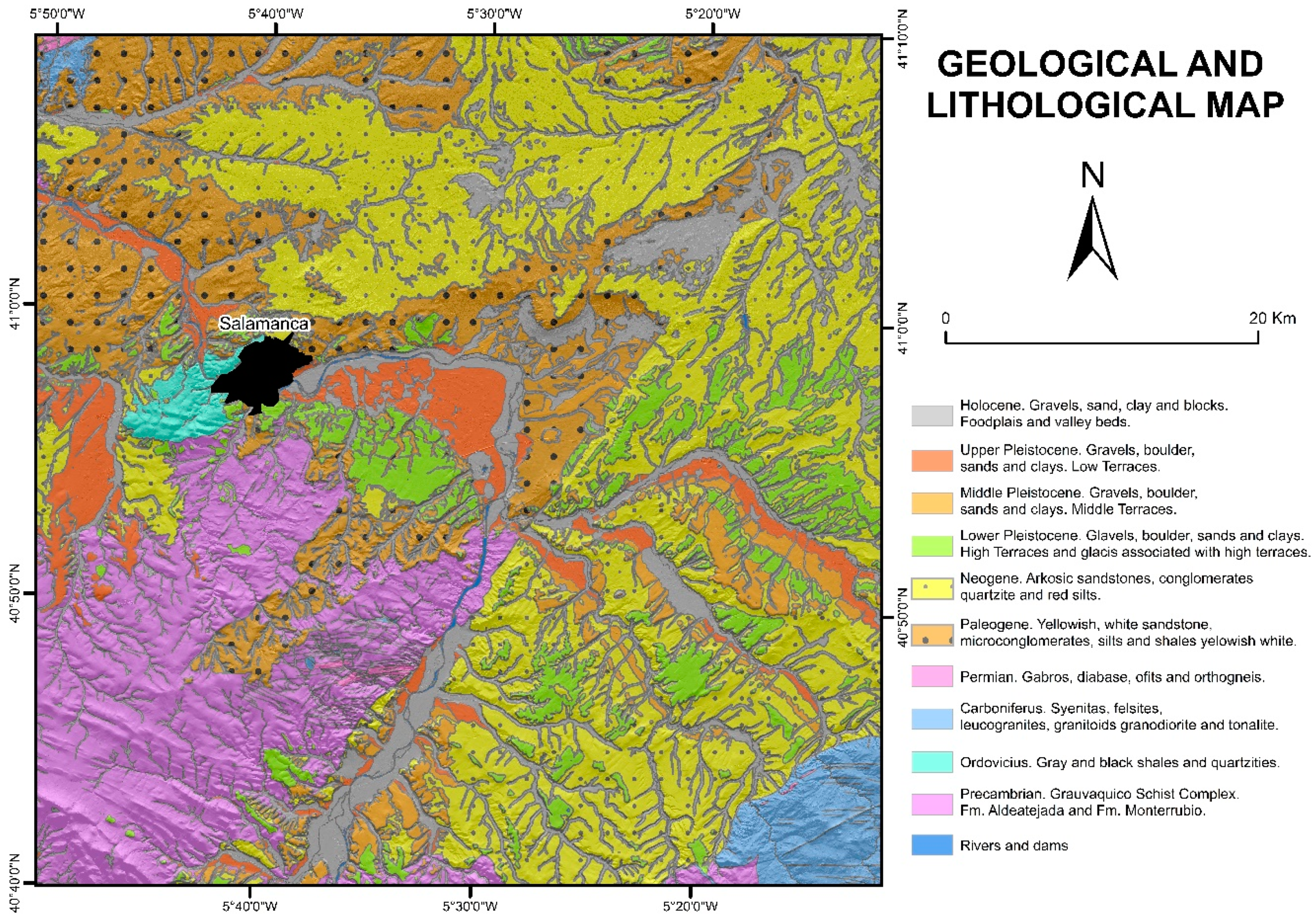
Geologically, this river belongs to the Central Iberian Zone [
5], where sediments of the Cambrian-Ordovician age are deposited on the Varisc basement, and materials of the final Mesozoic and Cenozoic age are recognized as filling the Duero basin (
Figure 2). The oldest known materials are from the Precambrian-Cambrian era and were formed by gneisses associated with slate and sandstone belonging to the so-called Greywacke Shale Complex. Particularly, in the study area, they are grouped into two formations: The Monterrubio Formation and the Aldeatejada Formation [
6]. The Ordovician rocks include sandstone, black and gray slate, and the quartzite "Armoricana Quartzite", which are located within the Iberian Massif that is located discordantly in the nuclei of the synclines. For the Carboniferous and Devonian eras, there is hardly any sedimentary record, but igneous rocks, granites, aplites, and pegmatites emerge [
7].
At the end of the Mesozoic, a distensive stage occurred, generating a dismantling in the raised reliefs and producing wide alluvial fans in the NE direction that gave rise to siliceous sandstones (Salamanca Sandstone Formation) composed of thick sands and gravels at the base and formed sand roofs, silt, and clays.
Cenozoic materials belong to the South-West part of the Duero Basin. During the filling, horst and grabens reliefs were produced, representing two stages: One exorheic during the Paleogene and one endorheic during the Neogen. The Paleogene stage is characterized by yellowish white sandstones, microconglomerates, silt and white-yellow shales, and siliceous sandstones. They correspond to river sediments formed by canal and avenue deposits, and above them are those of the flood plain. In the Neogen, the arc, sandstones, conglomerates, and red silts stand out, as does the Red Unit of the Neogen, which formed during the endorheic stage of the basin. This is of conglomeric character with sand and clay intercalations. In the Quaternary, the sedimentary record is linked to the activity of the Tormes River and the development of its valley. Its initiation is linked to an exorheic stage due to the clogging of the basin in the previous phase.
1.2. Geomorphological Context
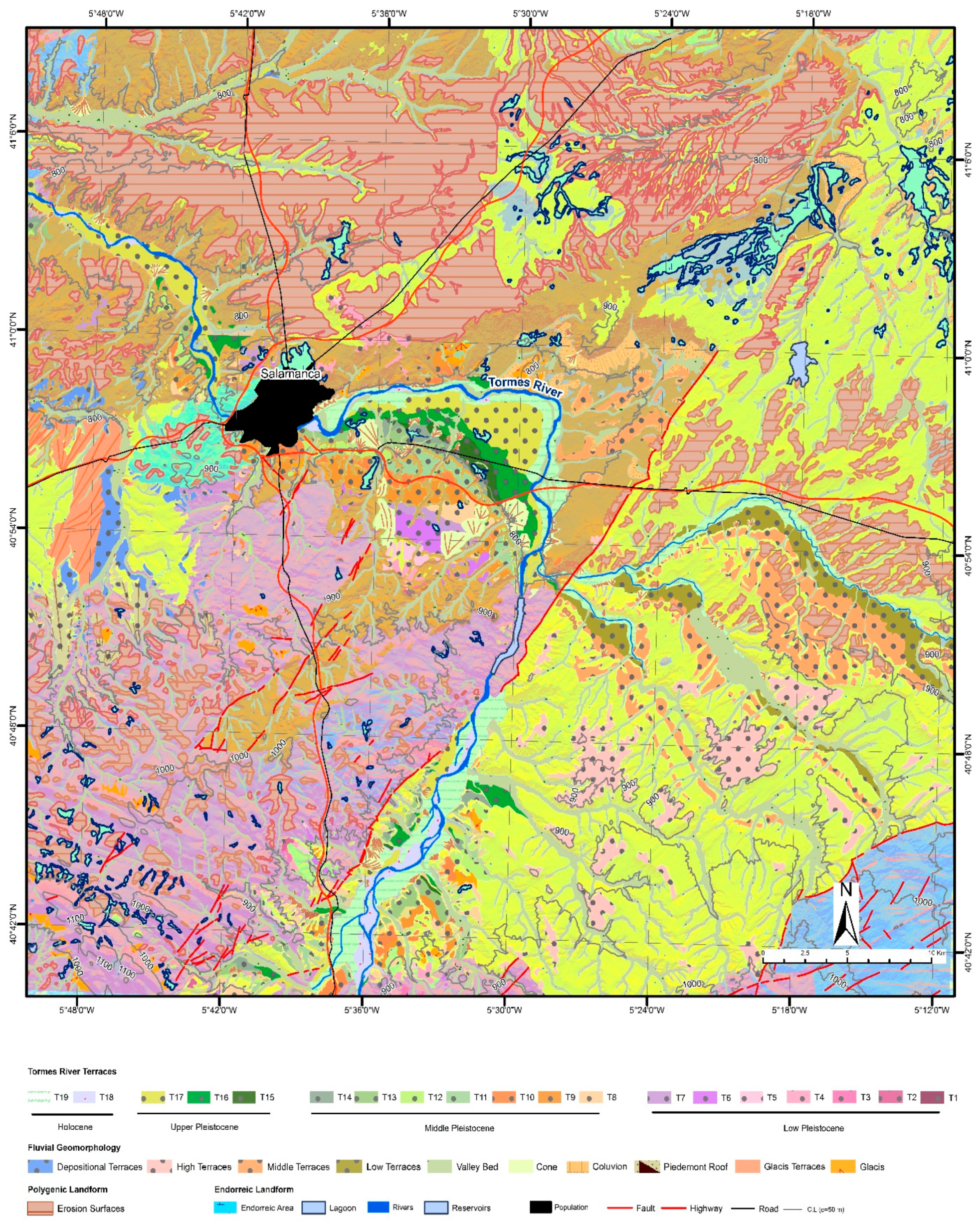
At the geomorphological level, a series of deposits located on the rooves of ancient alluvial fans that correspond to the onset of the river inset stand out (
Figure 3 and
Table 1). Embedded in these, the most important forms in the area are the quaternary erosive and depositional terraces, formed by accumulations of gravel, conglomerates, sand, and sometimes clays (sometimes crusted) with flat, stepped morphologies that are associated with the main rivers of the area, highlighting those of the Tormes river [
8,
9]. The valley funds are formed by deposits of sand, gravel, and scarce silty matrix. Alluvial fans and alluvial cones are formed in opening areas of secondary valleys that pour into the main river, causing the sedimentation of sands, silts, and gravels. With a conical shape, the most important ones are located on the low terraces. Pediments (glacis) are observed, which are siliciclastic sediments of streams formed by sands, silts, and gravels that give rise to relatively flat surfaces with less extension than terraces. Within the gravitational domain are colluvions (hillside deposits) that appear to be associated with the escarpments. Both rivers and structural components stand out, being abundant in the NE of the study area. Finally, within the endorheic domain, semiendorheic areas that form in carbonate rock dissolution environments stand out and are structures that generate temporary lagoons due to the waterproofing of their materials or the proximity of the water table [
10].
The most significant tectonic effects are neotectonics, which are associated with large reactivated varisc fractures that affect the geomorphology of the study area. The main direction of major faults such as Alba-Villoria is NNE–SSW, which causes a relevant morphological scarp as a result of its recent activity, affecting Neogenic deposits by tilting them towards the NE, resulting in an asymmetry of the river valleys of the Tormes and its tributaries (Almar, Gamo, and Margañán). This causes sequences of terraces on the left banks of the rivers and escarpments on the right banks (Tormes River, Almar, Regamon, Trabancos, Zapardiel, etc.) due to the general balancing of the Sierra de Béjar towards the NE. In addition to this mega-structure, there are numerous modifications of river courses in the area, following the NEN–WSW (Torremencías, south of Mozárbez, La Vellés, etc.), NW–SE (Almar, Gamo and Margañán), EW (Tormes River in Cabrerizos, east of Salamanca), and WNW–ESE (Tormes River northwest of Salamanca) directions.
2. Materials and Methods
To elaborate the geomorphological cartography, the following stages were carried out:
Firstly, an analysis of the geological cartography was carried out. The geomorphological cartography was elaborated on the same scale, and once the base maps were elaborated, the interpretation of different sectors was carried out by means of photointerpretation and verification in the field, assigning the new chronology of terraces with deposits and erosives for this central sector of the Tormes River sub-basin.
The geomorphological cartography was completed with the differentiation of the different morphogenetic systems (
Table 1), highlighting, above all, the river system, and within this, the sequences of erosive and depositional terraces. These cartographies were subsequently geo-referenced and digitized with GIS (ArcGis), which integrated them with the topographic cartography of the National Topographic Map at a scale of 1:50,000, and with the orthophotos (years 1956 and 2018) of the national plan of aerial orthophotography at a scale of 1:10,000.
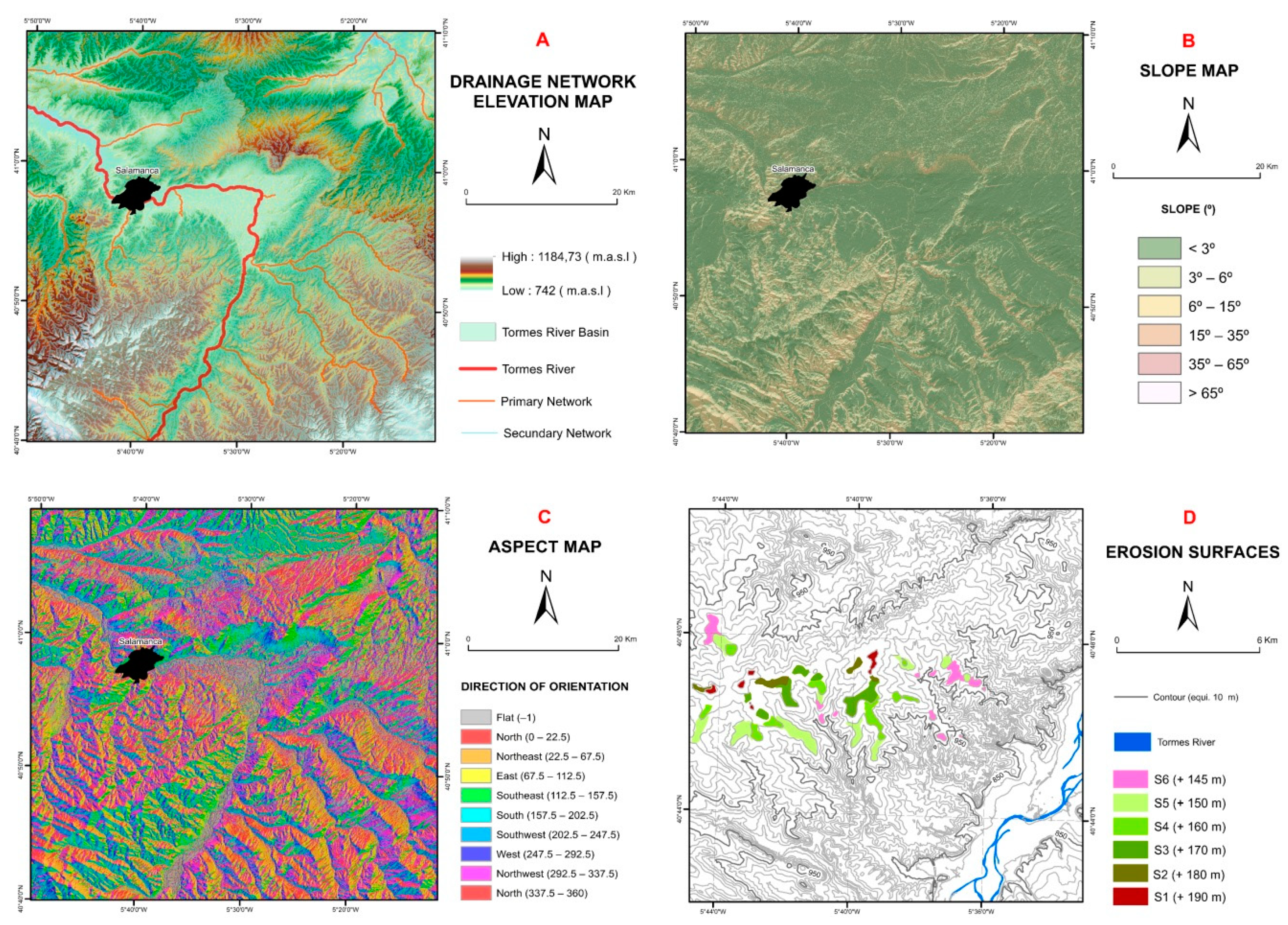
In a second stage, a digital terrain model with LiDAR data (spatial resolution: 1 m) was generated to recognize the different morphologies present in 3D, as well as to calculate the different levels of interest. From the digital terrain model, auxiliary maps were made to show the location, drainage, elevation, orientation, and slope (intervals selected according to the geomorphological characteristics of the area), in addition to an auxiliary geological–lithological map showing where the materials (conglomerates, gravels, sands, etc.) that constitute the deposits of the terraces came from, the pre-quaternary materials found, and a map of erosive surfaces (terraces) in the southern sector of the study area (
Figure 4).
In a third stage, the enlistment (incision) and river displacement rates were calculated, taking into account the relative height of each group of erosive and depositional terraces with respect to the river thalweg and the age at which they were deposited, grouping them into four eras: Lower Pleistocene, Middle Pleistocene, Upper Pleistocene, and Holocene; so the fitting rate is the ratio between the meters of incision or displacement and the elapsed time. The displacement rates of the main channel of the Tormes River were also calculated in relation to the times indicated for the incision, in meters of displacement per 1000 years. Two transversal profiles of the entire sequence of terraces and nineteen longitudinal profiles were generated crossing each terrace.
Finally, paleogeographic reconstruction of the area was carried out using a technique that is currently being developed and is used to model the relief and the processes that occurred in the past [
11,
12]. To do this, a small area with the most complete sequence of depositional terraces was located. To obtain the different models, the altimetry of the area was determined in the form of dimensions (points), the height of each terrace in meters, and the incision suffered by them at each time. The width of the channel was estimated by an approximate average (Equation (1)):
where “
x1” and “
xn” are the distances between each of the terrace levels of each era, divided by the number of points, that is, the total number of terrace levels there are. Based on this estimate and once the data was obtained, the digital terrain model was constructed, and the necessary knowledge was applied in terms of color techniques, shading, exposure to light, etc., to give a better view, and 3D views were generated with the ArcScene module.
3. Results
Based on the cartography, the different morphologies present were grouped into domains associated with different active processes. The main morphologies that stand out in the area are the sequence of terraces deposited by the river itself arranged in a staggered way dating back to the Quaternary. It is important to highlight another type of terrace at higher levels, in this case, erosive, which is associated with a set of river processes constituting coatings of low thickness [
13]. This type of terrace is presented in the same way and forms flat, inclined, and variable inclined lengths. A total of six levels were classified (S1 to S6), within which there were other sub-levels, highlighting that these surfaces are above the highest depositional terrace level (T1).
3.1. Sequence of River Terraces
A group of 19 river terraces with deposit (T1 to T19) in the northern sector and six previous erosive levels in the southern sector (S1 to S6) that formed during the Quaternary (
Table 2) were differentiated. They were classified according to their relative heights with respect to the elevation of the thalweg of the Tormes River, and they were assigned a relative chronology corresponding to the time in which they were deposited. Most of them were found to be arranged in elongated bands in the WNW–ESE direction in the north and NE–SW in the south. It is important to note that the continuity of the terraces (from T6) is affected by the narrowing of the Tormes River valley in the Tejares area, downstream of Salamanca, where the Tormes River fits into the Varisc basement, causing a coining of them. Sedimentologically, the levels belonging to the Lower Pleistocene are characterized by siliceous ridges, gravels, and arcosic sands, presenting a white-greenish clay matrix. The immediately higher levels belonging to the Middle Pleistocene are constituted of siliceous conglomerates, sands, and red silts, presenting tabular bodies of erosive bases and flat roofs. Those belonging to the Upper Pleistocene have siliceous conglomerates, sand, and ocher limos. Lastly, the ones closest to the current riverbed, attributed to the Holocene, contain deposits of sand, silt, and ridges. However, it should be noted that level T18 presents a morphology in the form of bars, and T19 corresponds to nearest terrace and next to the flood plain of the current river. The number of levels of river terraces present in the valleys will depend, in general, on the age and importance of the drainage basin, and in some cases, on the neotectonic activity.
3.2. Longitudinal and Transversal Profiles
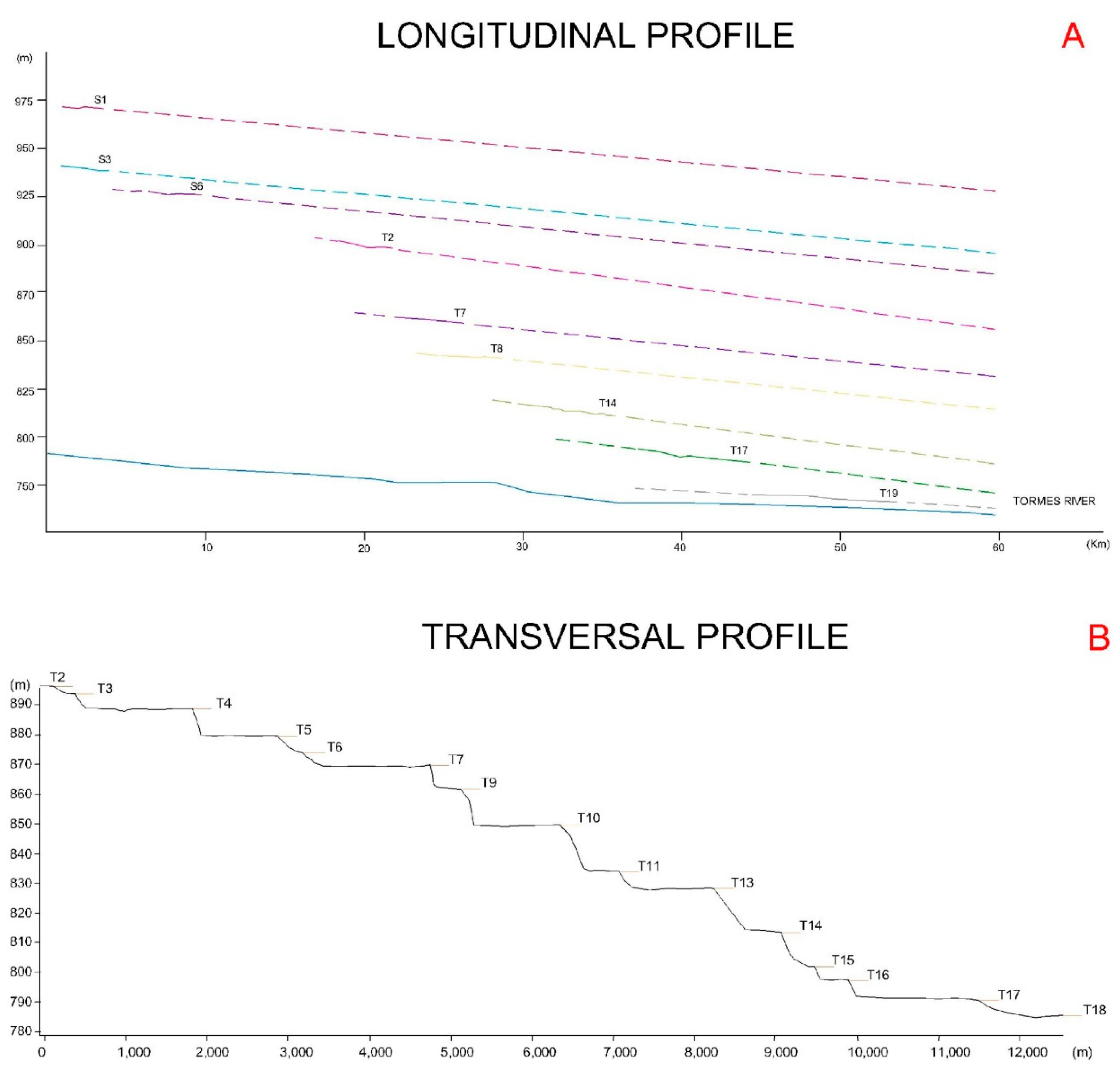
These two types of profile were made to study their arrangement according to their altitude. Of the 25 longitudinal profiles corresponding to each terrace, the most significant nine were chosen (
Figure 5). As general characteristics, we can highlight the low slope, the little separation between the terraces, and the divergence when leaving the Paleozoic materials, which converges again when leaving the basin when fitting in the same materials.
A cross-sectional profile was also selected (
Figure 5), cutting off most of the sequence of possible terraces where a difference in the heights of the steps shown in each of the terrace levels with respect to the previous one is observed due to climatic and/or neotectonic variations and the disparity in surface morphology as a result of erosion and depositional processes. The staggering is greater in the central zone than at the edges due to the hardness of the materials that the river has to erode, in one case, the soft (arc) materials of the Neogen, and in another case, the hard materials of the Paleozoic.
As for the extension they present, the most extensive terrace levels are T7, T10, T13, and T17, and the least extensive are T2, T6, T11, and T16. The staggering is also variable and can be correlated with terraces dated to other river valleys.
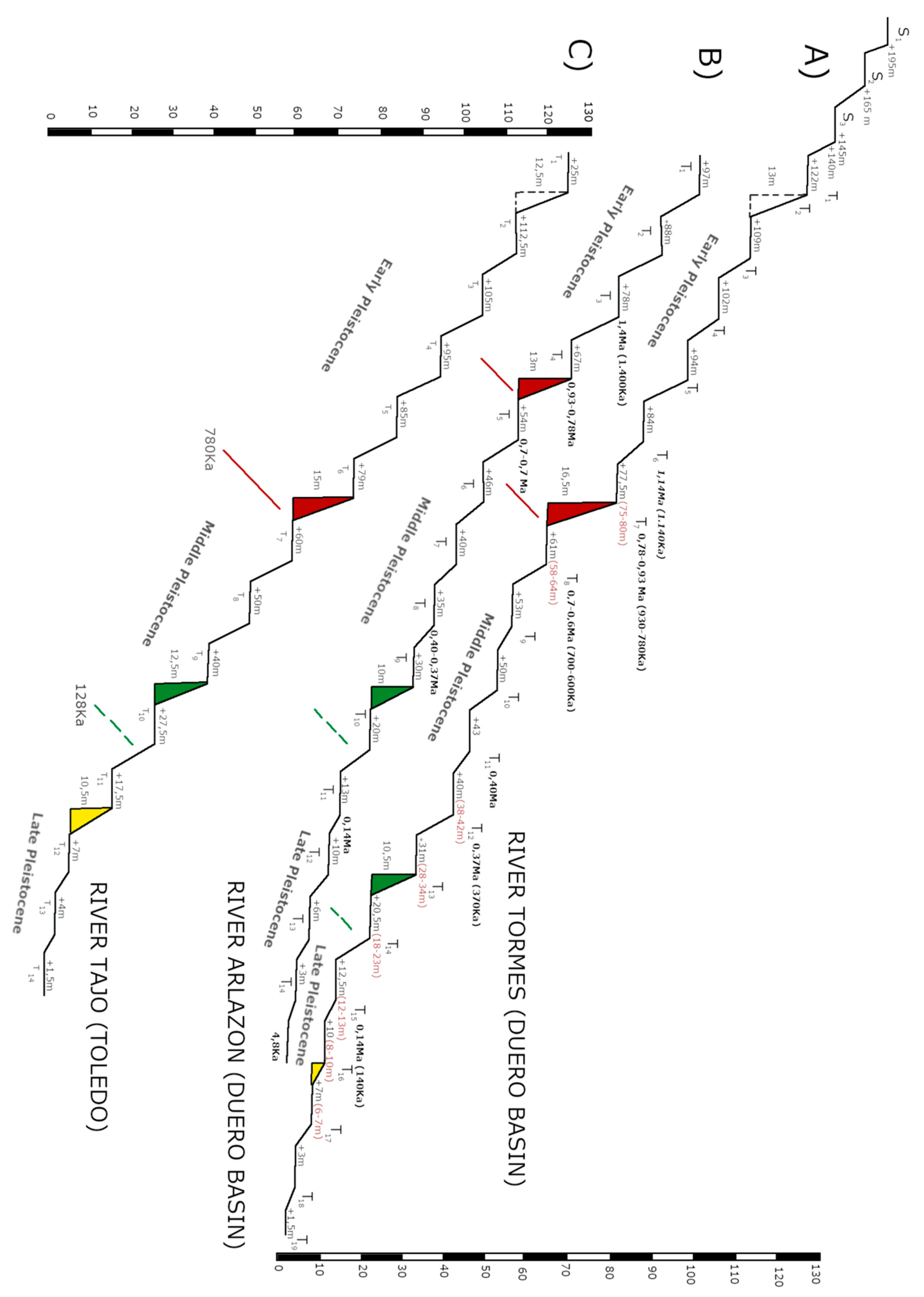
A synthetic scheme (maintaining the heights to scale) of the terrace levels of the Tormes River in the sub-basin of Salamanca (
Figure 6) indicates the heights relative to the thalweg and, as a result, the heights of the escarpments between successive terraces. We start with the hypothesis that the formation of the river terraces of the Spanish rivers originated, in general, in cold times (glacial and/or seasonal times), and the endangered species and edaphic levels originated in warm moments (interglacial and/or interstate). This was deduced on the basis of numerous existing dates (OSL, paleomagnetism, ESR...) and the presence of cold geomorphological features on the different deposits (cryoclasty, cryoturbations, ice wedges, etc.) and cold fauna associations of vertebrates and microvertebrates of terraced deposits.
If we evaluate the escarpments between successive terraces, different values can be seen that indicate variations in the climatic conditions of each moment because the interglacial periods did not have the same intensity or duration. Observing the escarpments of the Tormes River in the sequence shown, there are significant differences of more than 15 m between them (18 m T1–T2 and 2.5 m T15–T16). This allowed us to select the most important sequences to use as correlation elements in the river sequences of the same basin and basins with similar characteristics (Duero and Tagus Basins). In this case, the escarpments were selected between terraces T7 and T8 (16.5 m), T13 and T14 (10.5 m), and T16 and T17 (3 m).
Taking the sequence of the Arlanzón River as a reference for the correlation, within the same Duero basin when presenting paleomagnetic sampling and dating by ESR and TL [
2,
14,
15,
16], we can attribute these escarpments to a more precise chronology by being able to determine the boundaries between the lower, middle, and upper Pleistocene and Holocene. This type of correlation between escarpments can be used for related basins (Tagus Basin) (
Figure 7).
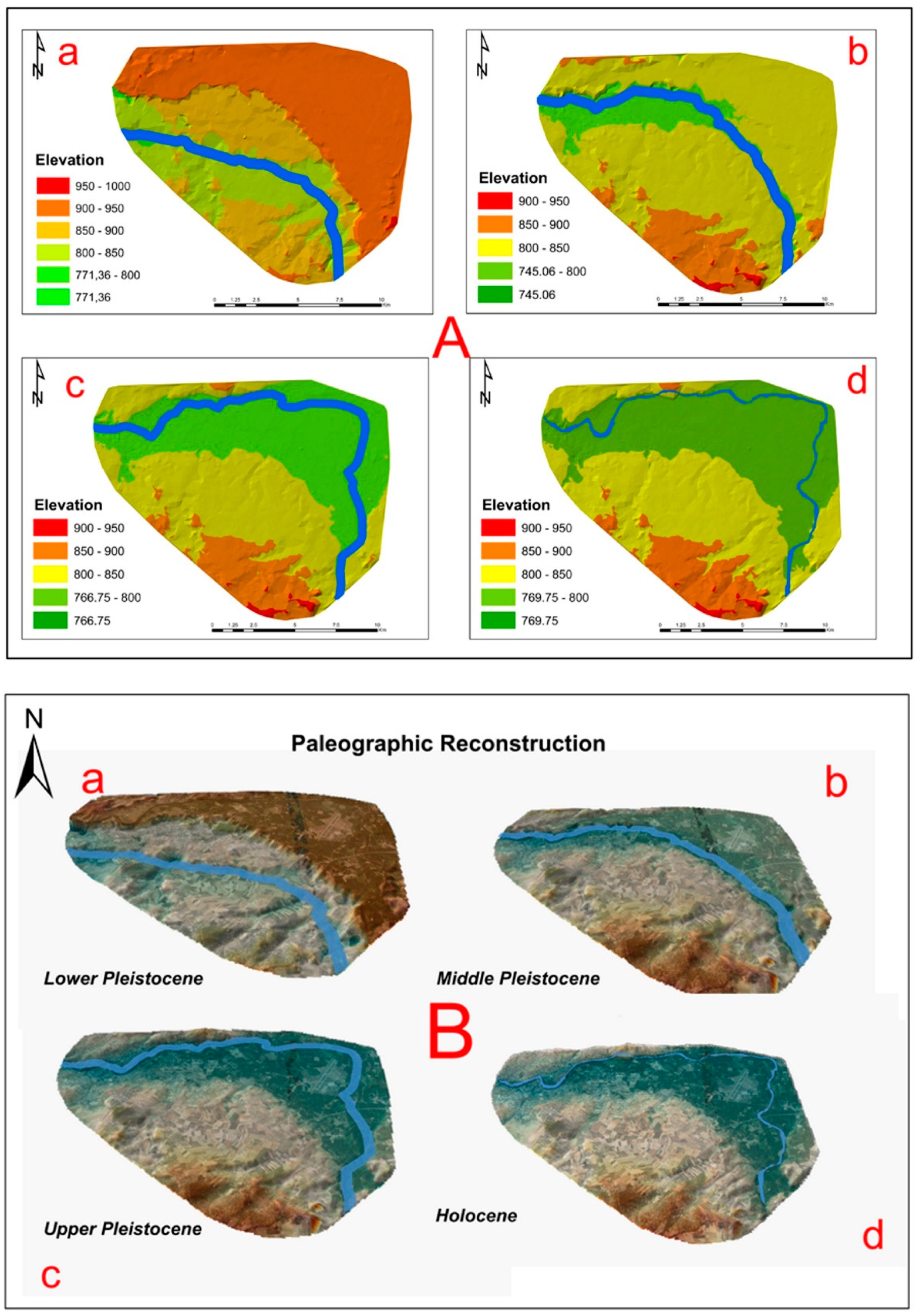
3.3. Paleogeographic Reconstruction: Incision and Displacement Rates
The concept of paleogeographic reconstruction or reconstruction of past reliefs includes a series of techniques based on the study of the physical environment, from the manual extension of the tendency of the morphology in a profile to more complex models, such as the reconstruction of paleo concrete surfaces [
17,
18,
19,
20,
21,
22,
23]. Since the surface to be reconstructed was a basin in this study, the TIN triangulation algorithm was chosen [
24].
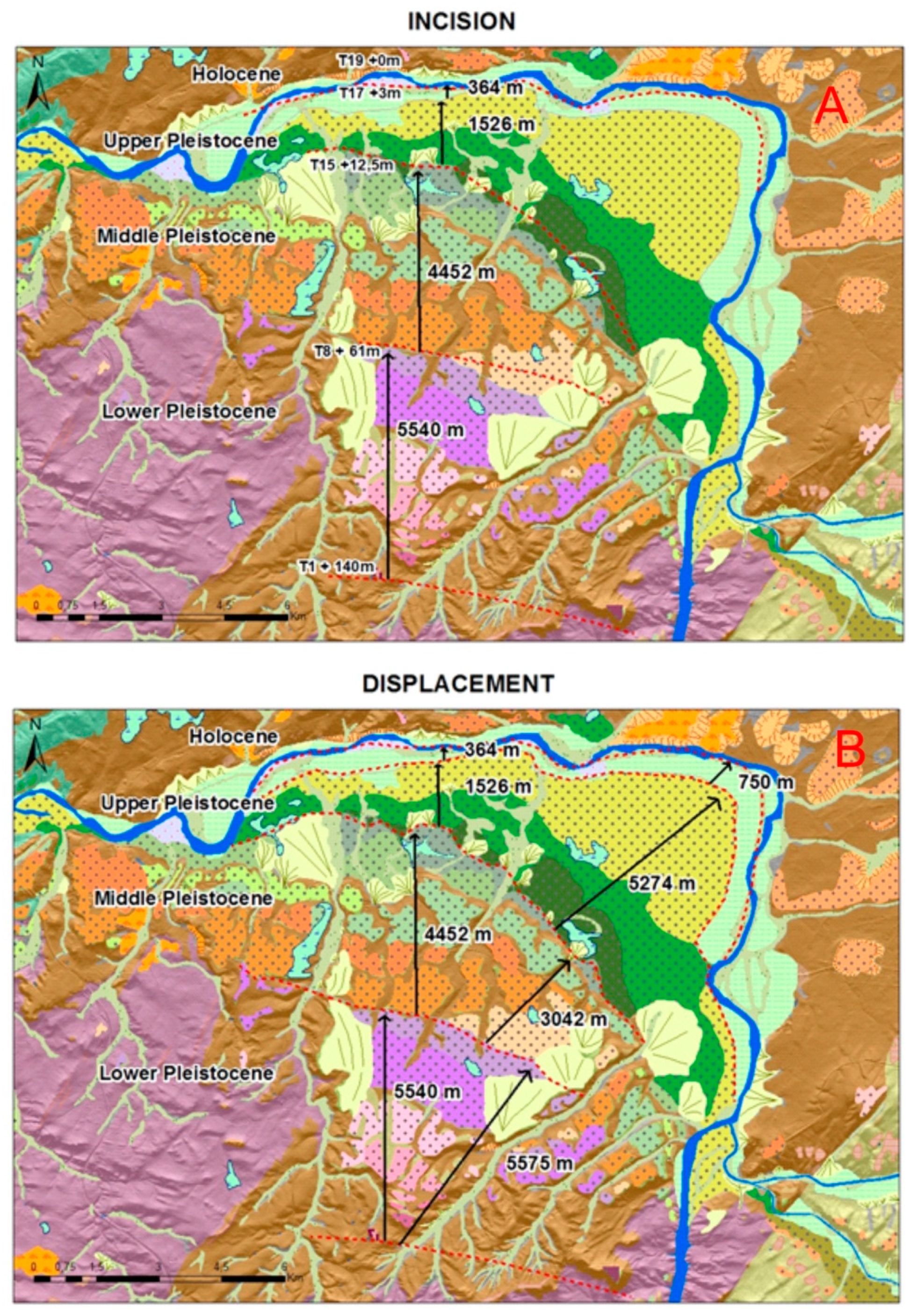
From the Lower Pleistocene to the Holocene, the relief gradually evolved so that, during the Lower Pleistocene, the Tormes River was located at a distance of about 8600 m with respect to the position currently occupied in the NE direction. During the Middle Pleistocene, it traveled 3700 m, and during the Upper Pleistocene, 500 m. At the same time that the displacement of the river in the NE direction was generated, the different levels of terraces caused by the river incision of the river were deposited, which corresponded to a displacement of the course of the river caused by neotectonic changes in an area south of the sierra (Sierra de Béjar), which tilted towards the NE and caused the river to move in the same direction (
Figure 8).
Two types of rates were used in this work: The incision rate related to the river fit and the general survey of the area, and that of lateral displacement related to the evolution of the river valley and its main channel due to the neotectonic activity.
We used a height of +190 m as the approximate age for the S1 level 2.35 million years (m.y.) ago (Gelasian age), considering this level is more recent than the deposits of the alluvial fan type "raña" that we considered with the age of onset of the Quaternary (2.58 m). The beginning of the Calabriense (1.8 m.y.) corresponds to the T1 height (+140 m), constituting the first terrace with a basin deposit, coinciding with the data indicated by [
2]. The beginning of the Middle Pleistocene (0.78 m) corresponds to the T8 height (+58–64 m), constituting the first positive value of the paleomagnetic scale (Brunhes) according to [
11]. The beginning of the Upper Pleistocene (0.130 m) was place on T15 with a height of +12–13 m from the date of the T11 terrace of the Almanzor River with a value of 0.140 m.y. at a river height of +12–14 m [
14].
In general, during the Lower Pleistocene, the incision rate was 0.0821 m/ka (meter/thousand year), while in the Middle Pleistocene, it was 0.0623 m/ka.
Table 3 shows that in the study area, the incision decreased from the Lower Pleistocene to the Middle, increasing again in the Upper Pleistocene, and then increasing much more during the Holocene.
The greatest fittings of the Tormes River occurred in the Holocene and the Upper Pleistocene, reducing towards the Lower Pleistocene and the Middle. The average incision rates for the entire Quaternary amounted to 0.0808 m/ka, considering not only the depositional terraces but also the erosive terraces belonging to the Gelasian (Lower Pleistocene), in which the height difference between the oldest and first T1 (Calabrian) was found to be 50 m with an age difference of 500 ka, so the fitting rate was 0.0909 m/ka. The rates for the Upper Pleistocene were found to be similar to those of the same time period in the Arlazón River (Duero Basin) [
14].
The displacement rates were relatively high and variable as we took steps perpendicular to the riverbed from T1 to T19. Very high displacement was found in the Upper Pleistocene and Holocene (12.89 m/ka and 31.11 m/ka), and when we analyzed Diagonal distances, the displacement increased considerably (44.58 m/ka and 64.10 m/ka). These data indicate the existence of a general movement of neotectonic origin due to the readjustments of the Central System (Sierra de Béjar) that swung during the Quaternary, especially from the Upper Pleistocene.
Figure 9 shows the evolution of the Tormes River during the Quaternary. The thalweg at the end of the Lower Pleistocene was located in the central area of the valley with considerable engagement (0.0821 m/ka) 129 m from T1 that progressively decreased (0.0623 m/ka) to 48.5 m during the Middle Pleistocene, rectifying its direction (initial section SN, middle section SSE–NNE and final section EW) during the Upper Pleistocene (9.5 m with an incision rate of 0.859 m/ka) to reach higher values in the Holocene (0.25 m/ka).
A dismantling of the relief occurred as time passed, as did an increase in the incision in the Upper Pleistocene, while the river changed direction from ESE–WNW to E–W. The movement of the channel decreased from the Lower Pleistocene to the Middle Pleistocene, and significantly increased in the Upper Pleistocene. From the Middle Pleistocene, the tilting of S to N at the regional level accelerated the displacement of the river.
4. Discussion
The geomorphological mapping generated with GIS techniques from Lidar data with 1 m spatial resolution allowed differentiation of the different geomorphological systems and the spatial delimitation of erosive and depositional river terraces. Georeferenced auxiliary maps such as the geological and lithological map complement the general information of the geomorphological map.
From the general sequence of terraces and the support of the longitudinal and transverse profiles of the terrain, it can be seen that although the sequence is staggered, when the river enters the Neogene basin, the (oldest) terraces diverge, while at the exit, the terraces (more modern) converge. This is due to the difference in the competition or resistance of the Paleozoic materials (more resistant entrances and exits) and the Cenozoic formed by basin filling materials (less resistant materials).
The cartography presents more developed terraces on the ground floor (T4, T7, T10, T13, and T17) and fittings of greater importance (T1–T2 18 m, T2–T3 13 m, T7–T8 16.5 m, T13–T14 10.5 m). These developed escarpments allow correlations between sequences of river terraces between rivers of the same basin and similar basins where climatic and neotectonic conditions are similar (Duero and Tajo Basin).
The incision rates for the Tormes River in the surroundings of the city of Salamanca decrease from the Middle Pleistocene (0.0821 to 0.0746 m/ka) and increase in the Upper Pleistocene (0.0746 to 0.0859 m/ka), presenting values higher than those of the Tagus River (0.2 m/ka) [
2], somewhat larger than those of the Arlanzon River (0.081 m/ka, Benito et al., 2018), and much lower than those of the Duero River in the Arribes del Duero, where the last 100 ka have values of 2–3 m/ka [
25].
5. Conclusions
The morphogenetical and chronological evolution is then established based on the relative age of the lithological units and the geomorphologic domains, as well as their spatial distribution. The analysis of the generators of the relief and their actions allows knowledge of the morphodynamics of the different geoforms, being able to know the different landscapes that have been developed in each region and to establish their relative evolution in time from the relative or absolute morphochronology. The analysis of the landscape from precise morphogenetic systems has allowed reconstructions paleoclimatic and paleogeographical, which identify the evolutionary phases of the relief with the time.
As for the rates of engagement, they are very high for the same periods of time, with a "rest" occurring for the Middle Pleistocene, and a large increase occurring for the Upper Pleistocene. This is related to regional neotectonics and affects the large active faults (Fault of Alba-Villoria), which delimit the area by the East, and the tilting of the Sierra de Béjar towards the NE, which forces the rivers to travel in the same direction.
The detail and precision of this geomorphological cartography allows the paleogeographic characterization of the area by showing the paleoreliefs through 3D models during the Quaternary, visually evaluating both the incisions and the fitting of the Tormes River, and studying its paleolandscapes and the evolutionary territorial morphology of the paleo channels and paleovalleys.


