Article

GIS Multi-Criteria Analysis by Ordered Weighted Averaging (OWA): Toward an Integrated Citrus Management Strategy

1
Faculty of Built Environment and Surveying, Universiti Teknologi Malaysia (UTM), Johor Bahru 81310, Malaysia
2
School of Environmental and Rural Science, University New England, Armidale, NSW 2351, Australia
3
Department of Social Science, University of Payam Noor, Tehran 19395-4697, Iran
4
Department of Geomorphology, Faculty of Natural Resources, University of Kurdistan, Sanandaj 66177-15175, Iran
5
Geoscience Platform Research Division, Korea Institute of Geoscience and Mineral Resources (KIGAM), 124, Gwahak-ro Yuseong-gu, Daejeon 34132, Korea
6
Department of Geophysical Exploration, Korea University of Science and Technology, 217 Gajeong-ro Yuseong-gu, Daejeon 34113, Korea
*
Authors to whom correspondence should be addressed.
Sustainability 2019, 11(4), 1009; https://0-doi-org.brum.beds.ac.uk/10.3390/su11041009
Submission received: 22 December 2018 / Revised: 9 February 2019 / Accepted: 12 February 2019 / Published: 15 February 2019

Abstract

:
This study proposes a site location assessment model for citrus cropland using multi-criteria evaluation (MCE) and the combination of a set of factors for suitability mapping and delineating the suitable areas for citrus production in Ramsar, Iran. It defines an incorporated method for the suitability mapping of the most appropriate sites for citrus cultivars with an emphasis on the multi-criteria decision analysis (MCDA) process. The combination of geographic information system (GIS) and a modified version of the analytic hierarchy process (AHP) based on the ordered weighted averaging (OWA) technique is also emphasized. The OWA is based on two principles, namely: the weights of relative criterion significance and the order weights. Therefore, the participatory technique was employed to outline the set of standards and the important criterion. The results derived from the GIS–OWA technique indicate that the cultivation of citrus is feasible only in limited areas, which make up 6.7% of the total area near the Caspian Sea. This investigation has shown that the GIS–OWA model can be integrated into MCDA to select the optimal site for citrus production. The present research highlights how multi-criteria in GIS can play a considerable role in decision making for evaluating the suitability of selected sites for citrus production.

1. Introduction

Land suitability evaluation is a procedure for assessing the prospective use of land for alternative purposes. The use of land for agriculture is considered critical areas in the scientific literature [1,2,3,4]. In general, land evaluation is the process of assessing the performance of land when used for a given purpose [5,6,7]. An evaluation of the climate, soil, and topographical components, along with an understanding of the biophysical constraints, are used to determine land suitability. The evaluation process is a crucial stage in the advancement of agricultural activities. The principal objective of the suitability evaluation of agricultural land forecasts the land’s prospects and constraints of the land for the production of crops [8,9,10,11].
The multi-criteria evaluation (MCE) is an operational instrument for addressing decision-making issues using multiple criteria [12,13,14]. The objective of the MCE is to examine selected possibilities based on multiple criteria and objectives [15]. The MCE technique, along with the geographic information system (GIS) can assist to categorize, examine, and appropriately organise the accessible information regarding choice-possibilities for spatial planning [16,17,18,19,20,21].
The analytic hierarchy process (AHP) is a multi-criteria decision-making (MCDM) method that helps the decision maker facing a complex problem with multiple conflicting and subjective criteria. AHP was evolved to optimize decision making when one is faced with a mix of qualitative and quantitative factors. It has been very effective in making complicated decisions, especially in project management. AHP methods roughly make up a fourth of MCDM studies in various fields [22]. The application of the AHP technique is profoundly considered; refer to [23].
The AHP framework is a popular MCDM tool for formulating and analyzing decisions, which can be used for ranking alternatives and estimating criteria weights through pair-wise comparisons [24,25]. Moreover, Ishizaka and Nemery, 2013 [26] pointed out that in problems involving the selection and ranking of multiple criteria, one of the most widely used methods is the analytic hierarchy process, or AHP.
The analytic hierarchy process (AHP) method proposed by Saaty, 1991 [27] is a recognized multi-criteria technique that is incorporated into the GIS-based procedures for determining suitability [28,29,30]. It computes the required weighting factors through a preference matrix that compares all the identified relevant criteria against one another. This is achieved through the use of reproducible preference factors, which then aggregate the weights of criterion map layers in the ordered weighted averaging (OWA) method. The AHP is particularly advantageous where it is impractical or difficult to identify the precise interactions between several evaluation criteria. Therefore, the OWA is a structure for the multi-criteria procedure in the GIS environment for aggregation [31,32,33]. The use of OWA operators is influenced by their ability to execute various selected operators by stipulating an opposite set of ordered weights, and hence its application is widely reported in the literature [34,35,36,37,38,39,40].
According to Yager, 1996 [41], the standard operators in OWA have limited uses in large-set criteria for evaluation. Based on the multifaceted spatial decision conditions, the decision maker might experience difficulties providing detailed numerical parametric information on OWA [12]. However, various strategic decision maps can be created by varying the weights of the orders in OWA.
Currently, the most popular techniques or decision rules in GIS are Boolean logic and weighted linear combination (WLC) [42,43,44], which are comprehensively described within the context of OWA [43]. However, [45] proposed the renowned procedure of AHP. It is an important procedure applied to problems of spatial decision characterized by large numbers of conditions [46]. As a multi-criteria decision-making method, the AHP has been applied for solving a wide variety of problems that involve complex criteria across different levels, where the interaction among criteria is common [47,48]. The AHP technique as an effective method is applied in the fields of soil management approach, e.g., a new method for soil health assessment [49] based on landslide [50], land-use change [51], regional resources in soils [52], and the determination of soil remediation schemes [53].
Furthermore, the AHP technique pools the significance of every level of a “criteria tree” comprising representative criteria levels. For this setting, an insignificant number of criteria can be calculated [54]. The integration of the OWA with AHP presents an effectively robust multi-criteria decision analysis (MCDA) instrument for problems regarding spatial decisions.
Although the use of MCDA for indistinctly assessing the suitability of agricultural sites is recognized, its adoption for mapping the suitability of the citrus site is lacking, at least to the best of the author’s knowledge. In addition, no studies have adopted the hydroclimatological impact assessment approach for categorizing suitable sites.
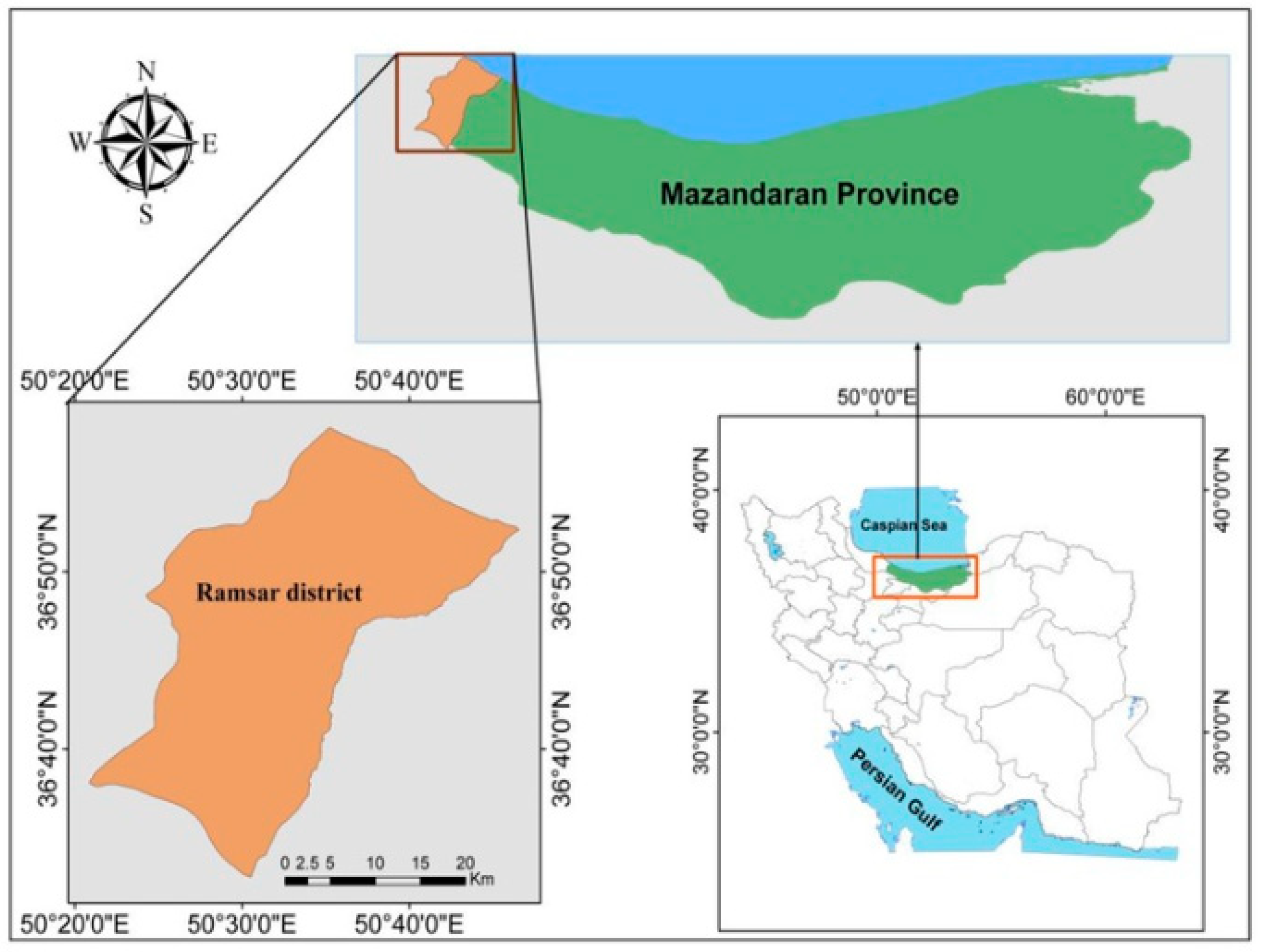
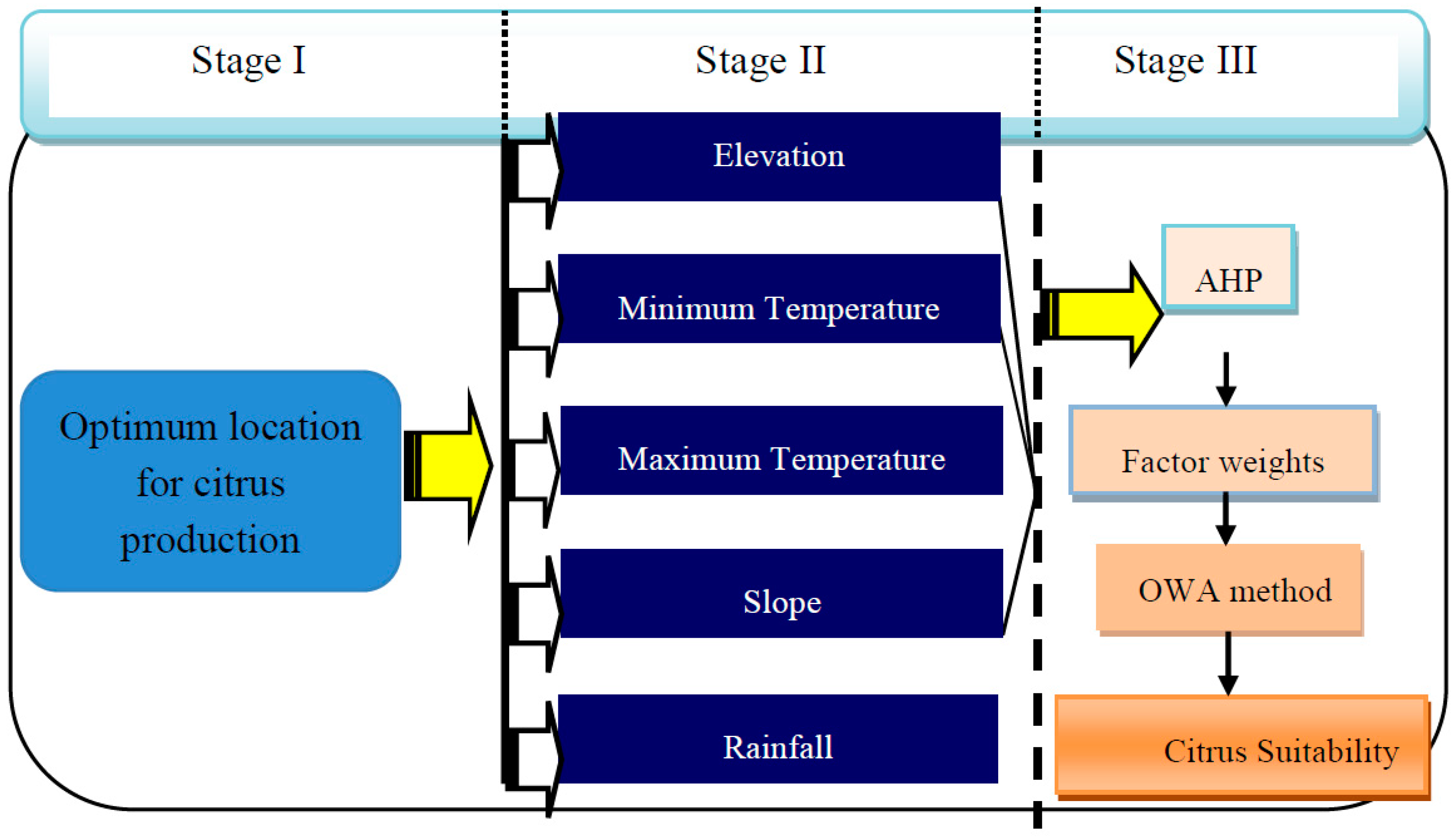
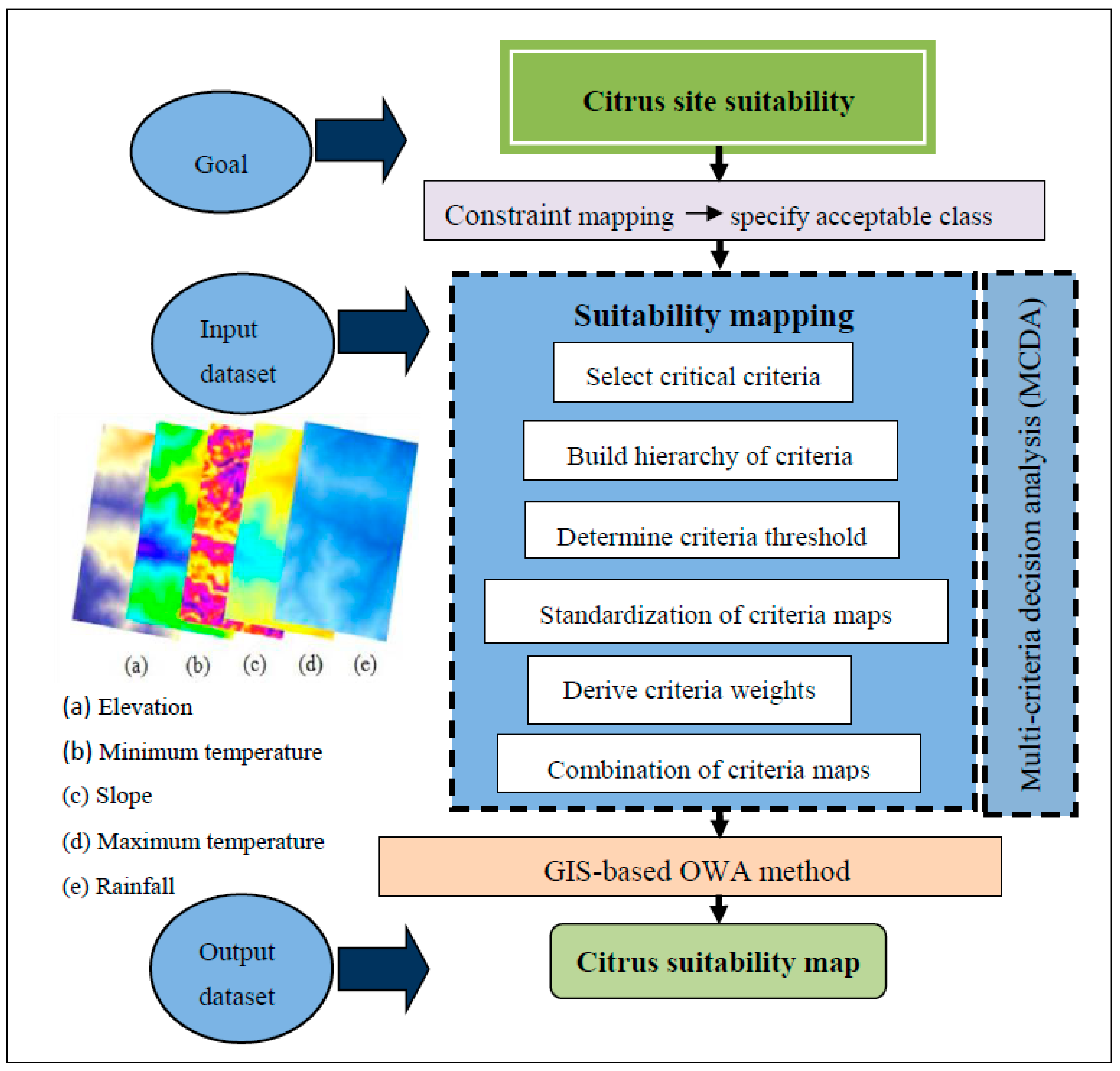
The aim of this study is to assist land managers with identifying areas with biophysical limitations based on the research criteria developed by the FAO (Food and Agriculture Organization) and modified by stakeholders. This study contributes to developing a GIS-based OWA approach for the citrus suitability assessment of the Ramsar district to identify the limitations that restrict the suitability classes for citrus production and recommend optimum citrus alternatives (scenarios) for improving citrus production.
The objectives of this research are to develop a GIS-based MCDA approach using the OWA and AHP methods for a citrus land suitability assessment model based on five (5) biophysical factors, and integrate the MCDA concept, as a core of GIS multi-criteria decision analysis, for the citrus-suitable regions in Ramsar district, Iran. To date, no research has been conducted on the MCDM approach, in particular, using the OWA method to access citrus site suitability in Iran, which will be discussed in this paper.
Although the developed methods can be used for citrus production management (CPM) through a set of spatial data, the issue of combining MCDM methods in the context of a GIS package is still considered as an important issue that few studies have tackled. Hence, GIS-based MCDA is an intelligent system that utilizes and converts spatial and non-spatial data into valuable information, which in addition to the judgment of the decision maker can be used to make a critical decision [55,56].
Overall, the contributions of this research are as follows:
  • An approach that combined AHP with OWA in a GIS environment is proffered. The present study focuses on an integrated citrus management strategy. Specifically, a GIS-based overlay analysis was performed to identify the optimum site for the citrus production that fulfilled all of the desired attributes.
  • Accordingly, this research tries to develop a new method, which is proposed by applying a novel GIS-based MCDM methodology for the assessment of citrus production.
  • A spatial framework adopting the AHP and OWA into the ArcGIS is used to evaluate the potential for the future expansion of citrus in Ramsar, Iran.
  • GIS is used for an important improvement to the conventional map overlay approaches.
Specifically, we appraise two key questions:
  • How can the citrus susceptibility problems be solved using a GIS-based OWA operator with a multi-criteria approach?
  • How can the critical factors by their relative weights, which are imported in GIS-based OWA capabilities, help decision makers with the citrus planning procedure now and in the future?
The remainder of this paper is organized as follows. Section 1 examines the existing research trends regarding the site suitability location, investigates five (5) crucial factors, and sets the scope of the methodology of the decision-making procedure. Section 2 proposes an OWA model in the GIS software for citrus growth potential and site values. The details of the OWA, including their comparisons, are described. Section 3 describes the test results of the OWA model for the potential for citrus orchards in the case study area by utilizing five (5) critical factors in the GIS and IDRISI Selva software. In Section 4 and Section 5, we discuss the application of this paper for strategy and future work. It is envisaged that the results of this work will enable planners and policy makers to better understand the key aspects of citrus sustainable management.

2. Materials and Methods

2.1. Study Site

The region that is examined in this work is situated 250 km north of Tehran. The area of Ramsar is positioned west of the region of Mazandaran, which is bordered by the Caspian Sea in the north and the Alborz Mountains in the south. It has a population of about 70,000 according to the 2018 census [57]. The region is an important area that is renowned for citrus production in Iran. The study site has approximately 6600 ha of citrus orchards [58]. The location is situated at latitudes 36°32′00″ to 36°59′11″ N and longitudes 50°20′30″ to 50°47′12″ E, and has a total area of about 736.6 km2. The elevation of Ramsar County is between −20 m to 3620 m above sea level, with the lowest point being the Caspian Sea. Its Mediterranean climate is characterized by warm yet dry summers with peak precipitation occurring from September to December. The average yearly rainfall in Ramsar is 1193.5 mm with an average yearly temperature of 17.6 °C. The hotness and aridness occur from May to August in the summer with average temperatures of about 25.2 °C during the warmest month of July [59]. A map of the area under study is presented in Figure 1.

2.2. Methodology

2.2.1. Data Collection and Preparation

The suitability analysis data that were used in this study were acquired from three sources. Based on the literature on the production of citrus, selecting citrus-growing areas requires the consideration of many factors, including rainfall, elevation, slope, and the minimum and maximum temperature [60,61,62]. Rainfall and air temperature are important meteorological parameters that significantly impact agricultural productivity [63,64,65]. The data was compiled from Ramsar agricultural organization, whereas the meteorological data was from meteorological stations. The climatological locations are distributed within the study area as observed from the climatic atlas of Iran and the Iran meteorological organization for the year 2013. A digital elevation model (DEM) of the study area, for the year 2011, was obtained from a geological survey of Iran.
The climatic data of 16 meteorological stations were acquired and examined from the climatological agency of the province of Mazandaran, which is located adjacent to the study area. The time series of the averaged station data used was 1980 to 2010, and met the 30-year requirement of the World Meteorological Organization (WMO). The distribution of the meteorological stations that was used for parameterizing the model was created in ArcGIS 10.2 [66]. The meteorological data layers that were employed were rainfall (hydroclimatological factors) derived from temperature isoline maps, along with the minimum and maximum temperature. The DEM dataset was derived from a topographic map with a resolution of 30 m on a 1:50,000 scale (obtained from the geological survey of Iran in 2011). The data of raster parameters such as the latitude, longitude, and terrain slope resulted from the DEM dataset at dimensions of 30 m × 30 m (obtained from the geological survey of Iran in 2011).
Subsequently, the hierarchical decision framework was developed in AHP as shown in Figure 2. The hierarchical structuring problems were applied to enable the explanation of outcomes through the comparison of the relative importance criteria of the process of policymaking [67]. Therefore, the most appropriate lands for cultivating citrus trees were identified through the criteria selection presented in stage II of Figure 2.

2.2.2. Ordered Weighted Averaging (OWA) Method

The OWA procedure is a class of combined multi-criteria technique that was established by [40], which appraises the significance of every factor at all of the locations and the importance of each factor based on its unique position. Yager, 1988 [41] developed OWA as a class of OWA multi-criteria combination operators. The OWA method provides a comprehensive range of policymaking methods spaced alongside the principal dimensions. As a result, there is a compromise degree concerning the criteria selected and the scale of the risk in the resolution. As can be observed in Figure 3, the space for this policymaking approach is located on the x-axis, which characterizes a range from extreme caution (low risk is run) to a completely acceptable risk factor. However, the y-axis signifies the range from no compromise to the maximum amongst the criteria.
Figure 3 displays the space for decision strategy in OWA modified from [42]. In general, the trade-off is a measure of the compensation of one criterion over another where the probability may be due to the risk of making a wrong decision. The OWA is a remarkable approach that is used to generate a variety of solution maps and predictive scenarios by reorganizing or varying the parametric criteria. Furthermore, the adoption of the OWA method ensures the comprehensive assessment of wide-ranging consequences, which can emanate from diverse managerial strategies. In the current study, the OWA method is used as the main model for citrus susceptible regions.
Based on the importance degree of each piece of data, the analytic hierarchy process (AHP) method is applied to determine each layer weight and derive a land suitability map. Consequently, with several sets of order weights, one can create a wide range of the OWA operators consisting of the most often used GIS-based map combination procedures, which as a sample is shown in Table 1 [12].
Basically, two parameters, ANDORness and TRADEOFF, were applied to characterize the nature of an OWA method:
ANDness = ( 1 / ( n 1 ) ) ( ( n i )   W order i )
ORness = 1 ANDness
where n is the total number of factors, i is the order of factors, and Worder i is the weight for the factor of the ith order. The ordered weighted averaging (OWA) operator provides continuous fuzzy aggregation operations between the fuzzy intersection (MIN or AND) and union (MAX or OR). A min–max disparity approach was used to assign order weights [68] as follows:
Minimize:
{ M a x j { 1 ,   , n 1 } | v j v j + 1 | }
Subject to
α = 1 n 1 j = 1 n ( n j ) v j ,   0 α 1 ,
j = 1 n vj = 1 , 0 vj 1 ,
in which ‘a’ reflected the degree of ANDness and ORness. When a =1, ANDness = 1 and ORness = 0; a = 0, then ANDness = 0, and ORness = 1. Besides:
TRADEOFF = 1 n ( W order   i 1 / n ) 2 n 1
The value of α controlled the position of the aggregation operator on a continuum between the extremes of MIN and MAX, as well as the degree of trade-off.
In addition, ORness is somewhere between AND or OR combination rules. The risk level in the preferred parameters is related to different values of ORness. ORness values from higher (extremely optimistic) or lower (extremely pessimistic) is the decision makers’ role. ORness = 1 is used as an optimistic approach, while ORness= 0 (AND situation) is used as a pessimistic plan (an extremely pessimistic one). The general procedure of OWA operators is summarized in Table 1.
The procedure that was adopted for the suitability of the suggested sites for citrus production was evaluated based on the methodology described in Figure 4. As observed, the schematic in Figure 4 shows the key decision phases for the spatial analysis and hydroclimatological evaluation. The map of constraints is used to mask suitability mapping, whereas the objective of the analytical problem, which was termed the “suitability map”, is hierarchically at the top.
From Figure 4, it can be seen that one of the effective factors for the most important comparisons is the weight analysis criteria. Pair-wise comparison was used with an expert’s opinion for calculating the weight importance of each relative factor to another factor. The condition of its calculation on the basis of AHP and consistency ratio was below 0.1. The AHP is obtained by calculating the comparative geometric average of each row and column. However, the weights of citrus and IDRISI Software were used for calculation. For cultivating citrus sites, OWA was used in multi-criteria decision making. The highest weight was given to a classification of factor map that obtains the first-class factors, or factors with higher preference degree, and has the most important role in land-use sites. Finally, suitability maps for the citrus site by multi-criteria and with OWA were produced. Table 2 lists the designated criteria that were used as constraints along with the threshold and suitability mapping. This was used to highlight the significance and practicality of the separate criterion that was adopted in the mapping the suitability of the citrus sites.
Land suitability is generally analyzed using MCE methods such as OWA. It entails standardizing and allocating the relative importance of weights to the suitability maps. Next, the weights and standardized suitability maps are combined to compute the complete suitability score [68]. After developing the decision hierarchy, each suitability analysis criterion was reclassified based on its suitability for citrus production.
C R = ( λ max n ) / ( n 1 ) R I
where the term λmax represent the highest eigenvalue and n is the number of factors, whereas the mean average consistency index is denoted by RI. Higher consistency and the acceptability of the AHP results as denoted by the relevant index should be below 0.10 [54]. The suitability score for each specific method is denoted by a statistical significance or score ranging from one to nine (Table 3).

3. Results

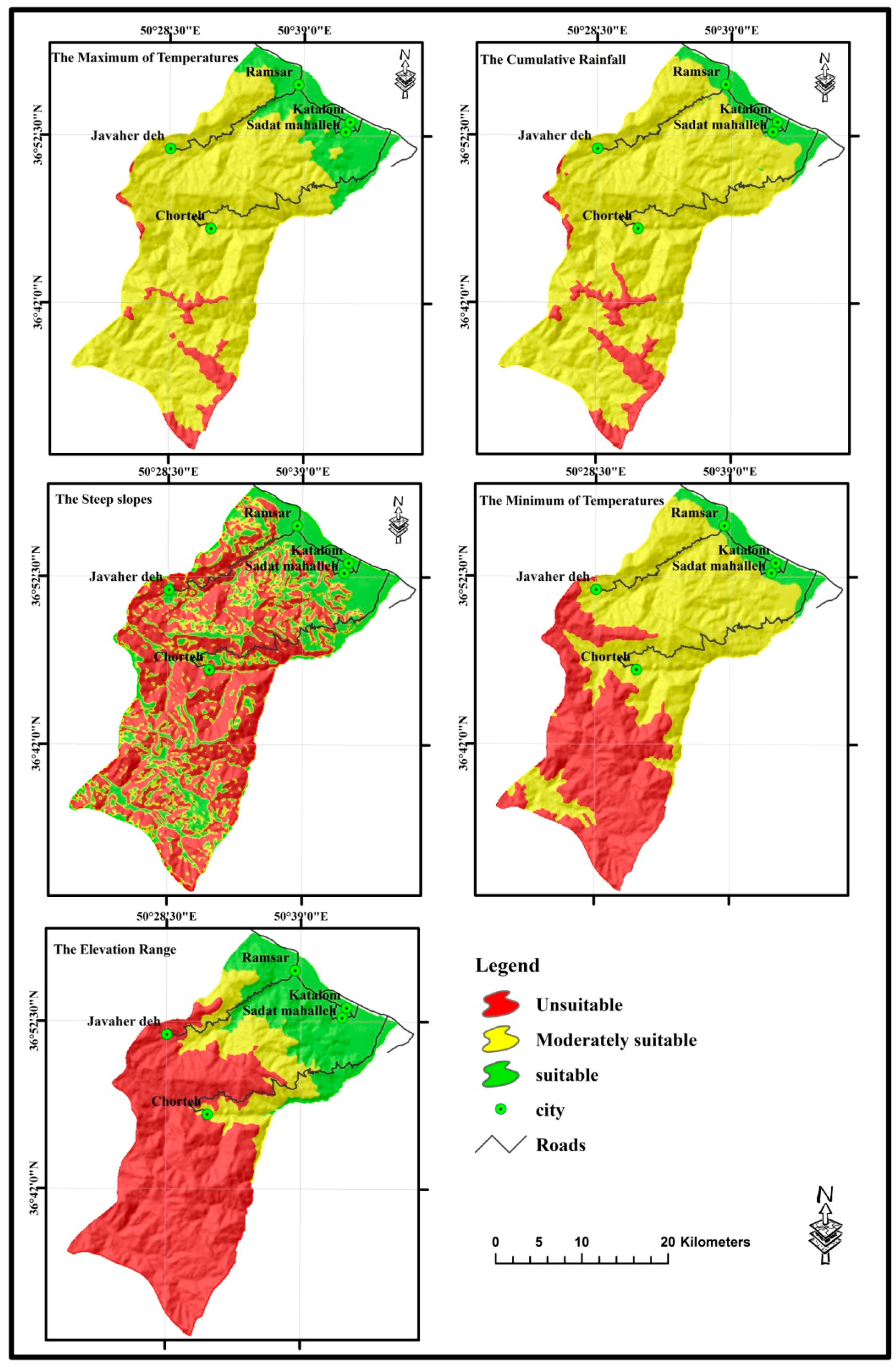
The suitability maps for citrus trees were derived from the criteria maps, and must be correlated to the findings of the AHP, based on the comparative significance of every criterion that was evaluated. Table 4 presents the pair-wise conditions developed in AHP for each adopted standard. Eigenvalues were used to designate the relative importance weight of each criterion.
Table 4 represents that elevation; lowest temperature and rainfall are the most important site factors for citrus production in Ramsar, Iran. Table 5 denotes that the most important condition for policymaking is elevation (46%). This is followed by a minimum temperature (23%), rainfall (14%), maximum temperature (10%), and slope angle (4%). As evaluated from Equation (4), the consistency ratio (CR) of the pair-wise matrix is 0.04, which indicates that the accumulated judgments derived from the pair-wise matrix from Table 5 are satisfactory. The comparative significance of individual standards is denoted by the eigenvalue [71]. Subsequently, the importance of individual site valuation standards was evaluated based on the comparative significance of each criterion and preferences according to specified decision rules. The selected criteria were: elevation, maximum temperature, minimum temperature, slope angle, rainfall, runoff coefficient, and slope, which were calculated by AHP through its pair-wise comparison matrix procedure.
The weights of the criteria are calculated by Equations (6–8), where the inconsistency index = 0.05; it is desirable to have a value of less than 0.1.
λ m a x = ( 1.87 × 0.462 ) + ( 11.3 × 0.106 ) + ( 4.86 × 0.236 ) + ( 21 × 0.04 ) + ( 9.7 × 0.144 ) = 5.22
C I = λ max n n 1 = 5.22 5 4 = 0.055
C R = C I R I = 0.055 / 1.12 = 0.04 < 0.1   ( a c c e p t a b l e )
where a calculated CR value below 0.1 indicates a ratio that designates a rational level of regularity in the pair-wise appraisal by an expert judgment in AHP. The random index is denoted by RI, which is the consistency index of a randomly generated pair-wise comparison matrix. It is evident that the RI is influenced by the number of factors under comparison (Table 6).
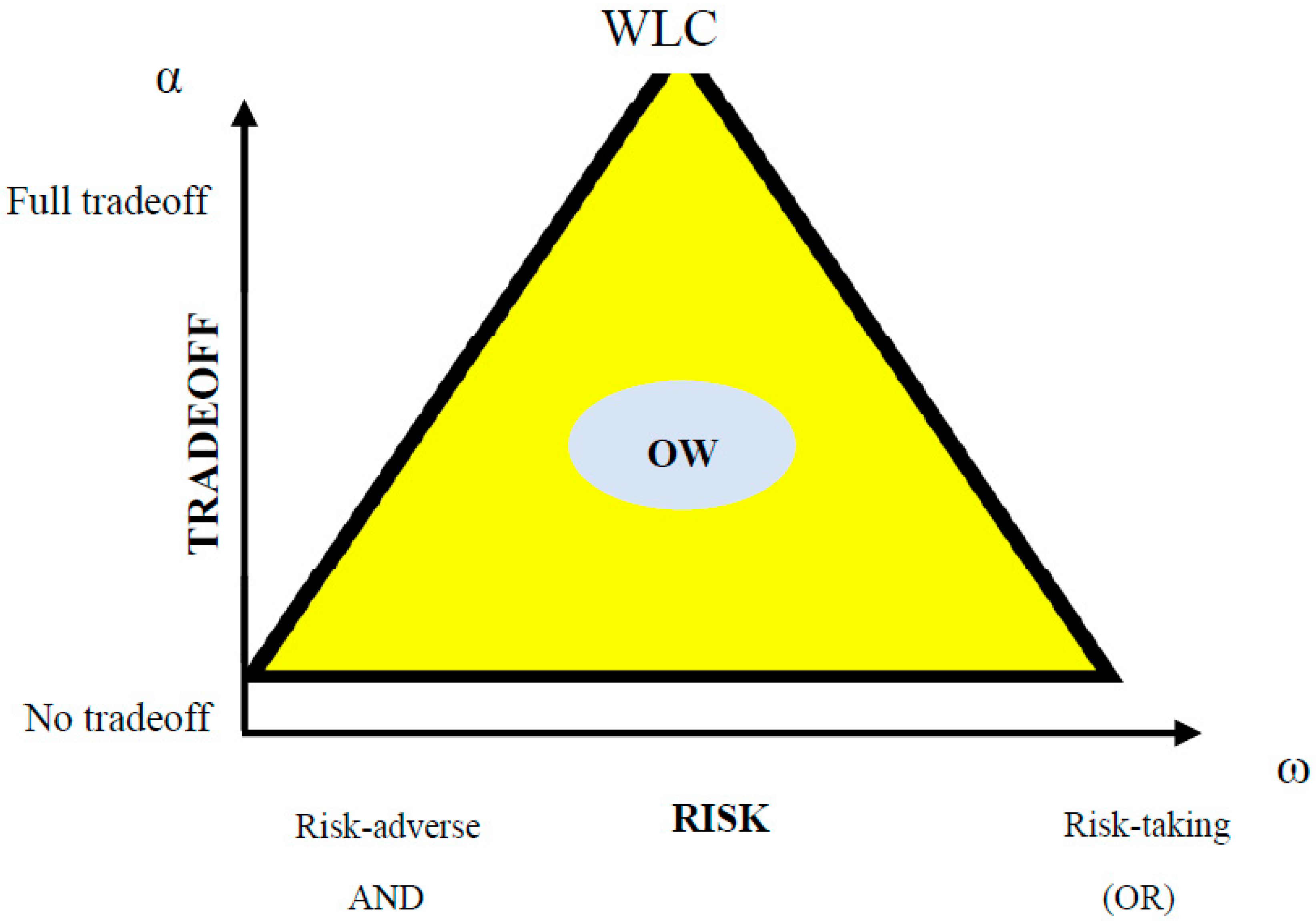
The OWA approach was employed to compute and aggregate various factors, weights, and constraint maps. In contrast to WLC, the approach of OWA requires additional weights that are termed order weights, and determine the combination of factor weights [72,73,74]. Therefore, the terms are defined as; Si = Suitability Index, Wi = criteria weights, Vj = criteria factor, Xi = criteria score of weight, and k = the number of criteria. OWA was obtained using the following function, Equation (9):
OWA i = j = 0 n ( U j V j j = 0 n U j V j ) Ζ j i
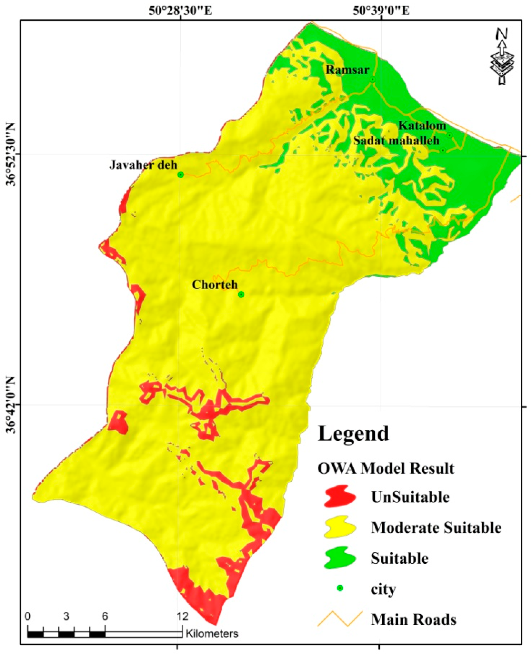
Consequently, the scale of one to three was selected such that one represents the least suitable, whereas three represents the most suitable. For the suitability analysis, each conditioning factor and the data layers listed were classified using OWA, as demonstrated in Figure 5. The results of this study provide the optimal regions for citrus productivity deduced by superimposing the five crucial layers depicted as in Figure 5.
The most potential sites evident from the lower elevation, optimum temperature, gentle slopes, and amount of rainfall regarding citrus trees requirement are given in Figure 5. The general suitability map generated by constraint mapping demonstrates the relative ranking of the potential sites based on the important criteria. The suitability scores specify that citrus orchards are highly suitable on the site located in the lowland regions. Based on the general suitability score (see Figure 6), 6.7% of the entire area is suitable for citrus growing, whereas 3.2% is unsuitable, and lastly, 90.1% is marginally suitable. This implies that the most suitable areas are located in northern parts, which have low elevation and flat topography (slope angle less than 15 degrees) and more than 800 mm year −1 of rainfall, which provides sufficient rain-fed irrigation, particularly regarding the monthly rainfall in late spring and mid-summer. After superimposing all five (5) conditions from ArcGIS (version 10.1), the three (3) zones of productivity that are appropriate for the sustainable production of citrus were mapped out as depicted in Figure 6.
From Figure 5, most of the region under study lacks a suitable value for citrus, as evident by the values approaching zero in the fuzzy map. The suitability analysis specifies an alteration in citrus site suitability based on the OWA method, which is ascribed to the decision maker’s changeable acceptance of risk. Therefore, the attitudes of different decision makers need to be considered in the process of citrus planning. The MCDA is a distinctive comparative tool that contributes to the better integration of various activities during horticultural management. As a result, nearly the whole feasible area (6.7% of the total area) is categorized as “suitable”. In this case, 90.1% of the region is categorized as being “moderately suitable”.
Thus, it is evident that the MCDA based on the OWA approach can reliably simulate various predilections of the decision maker based on citrus implementation. The results show that the proposed method i.e., OWA, is more applicable to assessing suitable citrus cropland. It can be applied to the other regions using these techniques and predominant factors in agronomy and horticultural sciences. Besides, the final map that was adopted indicated that the southern parts of the area under study were unsuitable for cultivating citrus. Lastly, the northern area was deemed the most appropriate with regard to citrus fertility. The percentage of optimal areas for citrus production is summarized in Table 7.
Thus, the final OWA map was generated by the GIS function for five parameters (see Figure 5). Accordingly, as shown in Table 7, the area with 6.7% (2348.01 hectares) is categorized as suitable in the OWA method. Second, in OWA, about 90.1% (66,359.46 hectares) of the predicted area was categorized as marginally suitable, and finally, in OWA, an amount of 3.2% (4,956.98 hectares) was determined to be unsuitable for cultivating citrus.

4. Discussion

According to the critical effective factors in the citrus site of each zone, GIS provides a suitable condition for data analysis. The GIS framework was adapted to determine the local priority of citrus activity in this study. AHP methodology has an important role in the quality and quantity classification. Accordingly, the result of OWA makes it possible to select a suitable area for cultivating citrus from the entire area in the Ramsar with three classes of relative priority.
The application of the OWA procedure can be adapted in a single operation, or as part of a hybrid scheme as a significant advantage of using this method. It entails that if one had five factors, where it was assigned that three should trade-off, but that two should not, the trouble can be resolved in two processes. In the first process, OWA would be run using order weights with the assigned degree of trade-off, followed by a second run without a trade-off in which the result of the first run was included as a supplementary factor. Factor weights can easily be set in the two runs to keep the original weights of all the factors.
The interesting feature of OWA is that it is possible to control a continuous degree of ANDORness and trade-off. In this case, OWA was derived from factor importance and different classification priorities along with a set of factor priorities and their internal classification priority; if the subject under study belongs to the highest class, decision making needs to be accomplished.
Therefore, OWA indicates that hydroclimatological evaluation classes are dividable to a different classification, and MCDM methods have only been used for cultivating citrus trees in determined places. It highlights that the determined weight has an important role in citrus cultivation factors. The result of this research in citrus can be used as an effective map of different factors in the OWA model. However, this may require finding justification for the non-acceptance of the proposed model in research for producers. More importantly, the OWA method can compliantly adhere to the diverse attitudinal decisions of the decision maker. It is theoretically effective, practically useful, and beneficial for dealing with problems in multiple criteria analysis. Conversely, a wide variety of strategic decisions can be made by altering the factors in the OWA technique.

5. Conclusions and Perspectives

In the GIS–MCE approach, two basic methods are used for environmental assessment: the WLC operators and the Boolean overlay operations. These procedures can be extracted through the scheme of the OWA. Hence, the study adopted a GIS-based framework based on the MCDM approach to examine the suitability of citrus cropland on a regional scale in Ramsar, Iran. It combines the proficiencies of OWA within the ArcGIS environment, and improves existing AHP modules. Furthermore, it improves the functionalities of ArcGIS by incorporating the multi-criteria decision analysis model. Lastly, the approach includes the opinions of experts on the standards and their weights, thereby providing a technique for directing the planner through the procedures required for the multi-criteria combination.
This study also reinforced the use of ordered weighted averaging (OWA) operators in AHP, which introduces the dimension of decision-maker’s attitude in the aggregation based on [75,76].
Suitability analysis allows identifying the main limiting factors for citrus production and enables decision makers to develop citrus management methods that enable increasing the citrus productivity. This paper proposes a quantitative and qualitative approach to suitable citrus cropland using GIS and MCE. A GIS-based MCE technique, using OWA strategies, examines the possible choices selected for problematic decisions by taking into account multiple conflicting criteria and objectives.
Hence, this study has outlined a GIS implementation of the ordered weighted average (OWA) operator that allows the exploration of a full range of operators such as intersection (AND) and union (OR). The GIS–OWA results are valuable tools that assist decision makers in order to determine suitable sites for optimum citrus production. In addition, the GIS-based MCE technique using OWA examined siting problems based on the various possible choices by addressing multiple criteria and contradictory objectives. The GIS–AHP module demonstrated that the tool was simple, spatial, and flexible. The results showed that the northern regions (mainly adjacent to the Caspian Sea) are the most suitable locations for citrus production in Ramsar. It allocates much more lands to the second level of suitability evaluation.
The hierarchical framework of AHP that was considered in this work presents an improved understanding of the problem and the importance of judgment required to reduce errors. The study successfully obtained numerous decision strategies and scenarios by altering the critical factors in the integrated method of OWA. The results derived from the OWA technique demonstrated that there are just a few areas, 6.7% of the total area, that were suitable for implementing citrus production. Lastly, the results highlighted that through altering the input criteria, a significant set of data, and the rules of decision, the multi-criteria analysis instrument is effective for varied disciplines. Accordingly, these include vulnerability valuation, land-use forecasting, and site assortment for agricultural (horticultural) crops.

Author Contributions

H.Z., M.A., P.K.L., M.K., H.S., A.A., M.N.S., and S.L. contributed equally to the work. H.Z. and M.A. collected field data and conducted the citrus analysis. H.Z., M.A., M.K., and H.S. wrote the manuscript. P.K.L., A.A., M.N.S., and S.L. provided critical comments in planning this paper and edited the manuscript. All of the authors discussed the results and edited the manuscript.

Funding

The authors wish to express their sincere thanks to Universiti Teknologi Malaysia (UTM) based on the Research University Grant (Q.J130000.2527.16H05) for their financial supports. Also, this research was supported by the Basic Research Project of the Korea Institute of Geoscience and Mineral Resources (KIGAM) funded by the Ministry of Science and ICT.

Conflicts of Interest

The authors declare no conflict of interest.

References

  1. Memarbashi, E.; Hossein Azadi, H.; Barati, A.K.; Fatemeh Mohajeri, F.; Van Passel, S.; Witlox, F. Land-Use Suitability in Northeast Iran: Application of AHP-GIS Hybrid Model. Isprs Int. J. Geo-Inf. 2017, 6, 396. [Google Scholar] [CrossRef]
  2. Zabihi, H.; Alizadeh, M.; Vogeler, I.; Ahmad, A.; Nor Said, M.; Ramezani Gourabi, B. Land allocation based on spatial analysis using artificial neural networks and GIS in Ramsar, Iran. Model. Earth Syst. Environ. 2017, 3, 1515–1527. [Google Scholar] [CrossRef]
  3. Pandey, B.; Seto, K.C. Urbanization and agricultural land loss in India: Comparing satellite estimates with census data. J. Environ. Manag. 2015, 148, 53–66. [Google Scholar] [CrossRef] [PubMed]
  4. Antonelli, M.; Siciliano, G.; Turvani, M.E.; Rulli, M.C. Global investments in agricultural land and the role of the EU: Drivers, scope and potential impacts. Land Use Policy. 2015, 47, 98–111. [Google Scholar] [CrossRef]
  5. Lee, T.M.; Yeh, H.C. Applying remote sensing techniques to monitor shifting wetland vegetation: A case study of Danshui River estuary mangrove communities, Taiwan. Ecol. Eng. 2009, 35, 487–496. [Google Scholar] [CrossRef]
  6. Cordioli, M.; Pironi, C.; De Munari, E.; Marmiroli, N.; Lauriola, P.; Ranzi, A. Combining land use regression models and fixed site monitoring to reconstruct spatiotemporal variability of NO2 concentrations over a wide geographical area. Sci. Total Environ. 2017, 74, 1075–1084. [Google Scholar] [CrossRef] [PubMed]
  7. Van den Bossche, J.; De Baets, B.; Verwaeren, J.; Botteldooren, D.; Theunis, J. Development and evaluation of land use regression models for black carbon based on bicycle and pedestrian measurements in the urban environment. Environ. Model. Softw. 2018, 99, 58–69. [Google Scholar] [CrossRef] [Green Version]
  8. Pan, G.; Pan, J. Research in crop land suitability analysis based on GIS. Comput. Comput. Technol. Agric. 2012, 365, 314–325. [Google Scholar]
  9. Aramburu Merlos, F.A.; Monzon, J.P.; Mercau, J.L.; Taboada, M.; Andrade, F.H.; Hall, A.J.; Jobbagy, E.; Cassman, K.G.; Grassini, P. Potential for Crop Production Increase in Argentina Through Closure of Existing Yield Gaps. Field Crop. Res. 2015, 184, 145–154. [Google Scholar] [CrossRef]
  10. Lamb, A.; Green, R.; Bateman, I.; Broadmeadow, M.; Bruce, T.; Burney, J.; Carey, P.; Chadwick, D.; Crane, E.; Field, R.; et al. The potential for land sparing to offset greenhouse gas emissions from agriculture. Nat. Clim. Chang. 2016, 6, 488–492. [Google Scholar] [CrossRef] [Green Version]
  11. Shen, J.; Huete, A.; Nguyen Tran, N.; Devadas, R.; Xuanlong Ma, X.; Eamus, D.; Yu, Q. Diverse sensitivity of winter crops over the growing season to climate and land surface temperature across the rainfed cropland-belt of eastern Australia. Agric. Ecosyst. Environ. 2017, 254, 99–110. [Google Scholar] [CrossRef]
  12. Malczewski, J. Ordered weighted averaging with fuzzy quantifiers: GIS-based multi-criteria evaluation for land-use suitability analysis. Int. J. Appl. Earth Obs. Geoinf. 2006, 8, 270–277. [Google Scholar] [CrossRef]
  13. Montgomery, B.; Dragićević, S.; Dujmović, J.; Schmidt, M. A GIS-based Logic Scoring of Preference method for evaluation of land capability and suitability for agriculture. Comput. Electron. Agric. 2016, 124, 340–353. [Google Scholar] [CrossRef]
  14. Grima, N.; Singh, S.J.; Smetschka, B. Improving payments for ecosystem services (PES) outcomes through the use of Multi-Criteria Evaluation (MCE) and the software OPTamos. Ecosyst. Serv. 2018, 29, 47–55. [Google Scholar] [CrossRef]
  15. Cover, S.J. Integrating multi-criteria evaluation with of the geographical information systems. Int. J. Geogr. Inf. Syst. 1991, 5, 321–339. [Google Scholar]
  16. Voogd, H. Multicriteria Evaluation for Urban and Regional Planning; Pion Limited: London, UK, 1983. [Google Scholar]
  17. Gorsevski, P.V.; Cathcart, S.C.; Mirzaei, G.; Jamali, M.M.; Ye, X.; Gomezdelcampo, E. A group-based spatial decision support system for wind farm site selection in Northwest Ohio. Energy Policy 2013, 55, 374–385. [Google Scholar] [CrossRef]
  18. Krois, J.; Schulte, A. GIS-based multi-criteria evaluation to identify potential sites for soil and water conservation techniques in the Ronquillo watershed, northern Peru. Appl. Geogr. 2014, 51, 131–142. [Google Scholar] [CrossRef]
  19. Dragićević, S.; Lai, T.; Balram, S. GIS-based multi-criteria evaluation with multiscale analysis to characterize urban landslide susceptibility in data-scarce environments. Habitat Int. 2015, 45, 114–125. [Google Scholar] [CrossRef]
  20. Flocard, F.; Ierodiaconou, D.; Coghlan, I.R. Multi-criteria evaluation of wave energy projects on the south-east Australian coast. Renew. Energy 2016, 99, 80–94. [Google Scholar] [CrossRef]
  21. Pujadas, P.; Pardo-Bosch, F.; Aguado-Renter, A.; Aguado, A. MIVES multi-criteria approach for the evaluation, prioritization, and selection of public investment projects. A case study city Barcelona. Land Use Policy 2017, 64, 29–37. [Google Scholar] [CrossRef]
  22. Mardani, A.; Zavadskas, E.K.; Khalifah, Z.; Jusoh, A.; Nor, K.M. Multiple criteria decision-making techniques in transportation systems: A systematic review of the state-of-the-art literature. Transport 2016, 31, 359–385. [Google Scholar] [CrossRef]
  23. Podvezko, V. Application of AHP technique. J. Bus. Econ. Manag. 2009, 10, 181–189. [Google Scholar] [CrossRef] [Green Version]
  24. Ramanathan, R. Data envelopment analysis for weight derivation and aggregation in the analytic hierarchy process. Comput. Oper. Res. 2006, 33, 1289–1307. [Google Scholar] [CrossRef]
  25. Velasquez, M.; Hester, P.T. An analysis of multi-criteria decision making methods. Int. J. Oper. Res. 2013, 10, 56–66. [Google Scholar]
  26. Ishizaka, A.; Nemery, P. Multi-Criteria Decision Analysis: Methods and Software; Wiley: Chichester, UK, 2013. [Google Scholar]
  27. Saaty, T.L.; Vargas, L.G. Prediction, Projection and Forecasting; Kluwer Academic Publishers: Dordrecht, The Netherlands, 1991; p. 251. [Google Scholar]
  28. Marinoni, O. Implementation of the analytical hierarchy process with VBA in ArcGIS. Comput. Geosci. 2004, 30, 637–646. [Google Scholar] [CrossRef]
  29. Zhang, J.; Su, Y.; Wu, J.; Liang, H. GIS based land suitability assessment for tobacco production using AHP and fuzzy set in Shandong province of China. Comput. Electron. Agric. 2015, 114, 202–211. [Google Scholar] [CrossRef]
  30. Bozda˘g, A.; Yavuz, F.; Günay, A.S. AHP and GIS based land suitability analysis for Cihanbeyli (Turkey) County. Environ. Earth Sci. 2016, 75, 1–15. [Google Scholar]
  31. Yager, R.R. On ordered weighted averaging aggregation operators in multi-criteria decision making. IEEE Trans. Syst. Man Cybern. 1988, 18, 183–190. [Google Scholar] [CrossRef]
  32. Wanderer, T.; Herle, S. Creating a spatial multi-criteria decision support system for energy related integrated environmental impact assessment. Environ. Impact Assess. Rev. 2015, 52, 2–8. [Google Scholar] [CrossRef]
  33. Shen, J.; Lu, H.; Zhang, Y.; Song, X.; He, L. Vulnerability assessment of urban ecosystems driven by water resources, human health and atmospheric environment. J. Hydrol. 2016, 536, 457–470. [Google Scholar] [CrossRef]
  34. Malczewski, J.; Chapman, T.; Flegel, C.; Walters, D.; Shrubsole, D.; Healy, M.A. GIS-multi-criteria evaluation with ordered weighted averaging (OWA): A case study of developing watershed management strategies. Environ. Plan. 2003, A 35, 1769–1784. [Google Scholar] [CrossRef]
  35. Makropoulos, C.; Butler, D. Spatial ordered weighted averaging: Incorporating spatially variable attitude towards risk in spatial multi- criteria decision-making. Environ. Model. Softw. 2005, 21, 69–84. [Google Scholar] [CrossRef]
  36. Aydin, N.Y.; Kentel, E.; Duzgun, S. GIS-based environmental assessment of wind energy systems for spatial planning: A case study from Western Turkey. Renew. Sustain. Energy Rev. 2010, 14, 364–373. [Google Scholar] [CrossRef]
  37. Nadi, S.; Delavar, M.R. Multi-criteria, personalized route planning using quantifier-guided ordered weighted averaging operators. Int. J. Appl. Earth Obs. Geoinf. 2011, 13, 322–335. [Google Scholar] [CrossRef]
  38. Ferretti, V.; Pomarico, S. Ecological land suitability analysis through spatial indicators: An application of the Analytic Network Process technique and Ordered Weighted Average approach. Ecol. Indic. 2013, 34, 507–519. [Google Scholar] [CrossRef]
  39. Rahman, M.A.; Rusteberg, B.; Uddin, M.S.; Lutz, A.; Saada, M.A.; Sauter, M. An integrated study of spatial multi-criteria analysis and mathematical modelling for managed aquifer recharge site suitability mapping and site ranking at Northern Gaza coastal aquifer. J. Environ. Manag. 2013, 124, 25–39. [Google Scholar] [CrossRef] [PubMed]
  40. Mokarram, M.; Hojati, M. Using ordered weight averaging (OWA) aggregation for multi-criteria soil fertility evaluation by GIS (case study: Southeast Iran). Comput. Electron. Agric. 2017, 132, 1–13. [Google Scholar] [CrossRef]
  41. Yager, R.R. Quantifier guided aggregation using OWA operators. Int. J. Intell. Syst. 1996, 11, 49–73. [Google Scholar] [CrossRef]
  42. Eastman, J.R. IDRISI for Windows, Version 2.0: Tutorial Exercises Graduate School of Geography; Clark University: Worcester, MA, USA, 2001. [Google Scholar]
  43. Malczewski, J.; Rinner, C. Exploring multi-criteria decision strategies in GIS with linguistic quantifiers: A case study of residential quality evaluation. J. Geogr. Syst. 2005, 7, 249–256. [Google Scholar] [CrossRef]
  44. Abudeif, A.M.; Abdel Moneim, A.A.; Farrag, A.F. Multicriteria decision analysis based on analytic hierarchy process in GIS environment for siting nuclear power plant in Egypt. Ann. Nucl. Energy 2015, 75, 682–692. [Google Scholar] [CrossRef]
  45. Saaty, T.L. The Analytical Hierarchy Process; McGraw-Hill: New York, NY, USA, 1980. [Google Scholar]
  46. Boroushaki, S.; Malczewski, J. Implementing an extension of the analytical hierarchy process using ordered weighted averaging operators with fuzzy quantifiers in ArcGIS. Comput. Geosci. 2008, 34, 399–410. [Google Scholar] [CrossRef]
  47. Tiwari, D.N.; Loof, R.; Paudyal, G.N. Environmental-economic decision-making in lowland irrigated agriculture using multi-criteria analysis techniques. Agric. Syst. 1999, 60, 99–112. [Google Scholar] [CrossRef]
  48. Feizizadeh, B.; Jankowski, P.; Blaschke, T. A GIS based spatially-explicit sensitivity and uncertainty analysis approach for multi-criteria decision analysis. Comput. Geosci. 2014, 64, 81–95. [Google Scholar] [CrossRef] [PubMed] [Green Version]
  49. Xue, R.; Wang, C.; Liu, M.L.; Zhang, D.; Li, K.; Li, N. A new method for soil health assessment based on Analytic Hierarchy Process and meta-analysis. Sci. Total Environ. 2019, 650, 2771–2777. [Google Scholar] [CrossRef] [PubMed]
  50. Mandal, B.; Mandal, S. Analytical hierarchy process (AHP) based landslide susceptibility mapping of Lish river basin of eastern Darjeeling Himalaya, India. Adv. Space Res. 2018, 62, 3114–3132. [Google Scholar] [CrossRef]
  51. Kundu, S.; Khare, D.; Mondal, A. Landuse change impact on sub-watersheds prioritization by analytical hierarchy process (AHP). Ecol. Inform. 2017, 42, 100–113. [Google Scholar] [CrossRef]
  52. Liang, R.; Song, S.; Shi, Y.; Shi, Y.; Lu, Y.; Zheng, X.; Xu, X.; Wang, Y.; Han, X. Comprehensive assessment of regional selenium resources in soils based on the analytic hierarchy process: Assessment system construction and case demonstration. Sci. Total Environ. 2017, 605–606, 618–625. [Google Scholar] [CrossRef] [PubMed]
  53. Li, X.; Li, J.; Sui, H.; He, L.; Cao, X.; Li, Y. Evaluation and determination of soil remediation schemes using a modified AHP model and its application in a contaminated coking plant. J. Hazard. Mater. 2018, 353, 300–311. [Google Scholar] [CrossRef] [PubMed]
  54. Saaty, T.L. How to make a decision: The analytic hierarchy process. Eur. J. Oper. Res. 1990, 48, 9–26. [Google Scholar] [CrossRef]
  55. Sumathi, V.R.; Natesan, U.; Sarkar, C. GIS-based approach for optimized siting of municipal solid waste landfill. Waste Manag. 2008, 28, 2146–2160. [Google Scholar] [CrossRef] [PubMed]
  56. Chen, Y.; Yu, Y.; Khan, S. Spatial sensitivity analysis of multi-criteria weights in GIS-based land suitability evaluation. Environ. Model. Softw. 2010, 25, 1582–1591. [Google Scholar] [CrossRef]
  57. Statistical Center of Iran, Archives Bureau. 2018. Available online: https://www.amar.org.ir/ (accessed on 9 February 2019).
  58. Ramsar Agriculture Organization, Census Bureau. 2016. Available online: http://jkmaz.ir/ramsar (accessed on 9 February 2019).
  59. Ramsar Meteorological Administration, Archives Bureau. 2018. Available online: https://www.irimo.ir/far/wd/701 (accessed on 9 February 2019).
  60. Coltro, L.; Mourad, A.L. Assessing the environmental profile of orange production in Brazil. Int. J. Life Cycle Assess. 2009, 14, 656–664. [Google Scholar] [CrossRef]
  61. García-Tejero, I.; Romero-Vicente, R.; Jiménez-Bocanegra, J.A.; Martínez-García, G.; Durán-Zuazo, V.H.; Muriel-Fernández, J.L. Response of citrus trees to deficit irrigation during different phenological periods in relation to yield, fruit quality, and water productivity. Agric. Water Manag. 2010, 97, 689–699. [Google Scholar] [CrossRef]
  62. Wu, W.; Liu, H.; Dai, H.; Li, W.; Sun, P. The management and planning of citrus orchards at a regional scale with GIS. Precis. Agric. 2011, 12, 44–54. [Google Scholar] [CrossRef]
  63. Hatfield, J.L.; Boote, K.J.; Kimball, B.A.; Ziska, L.H.; Izaurralde, R.C.; Ort, D.; Thomson, A.M.; Wolfe, D. Climate Impacts on Agriculture: Implications for Crop Production. Agron. J. 2011, 103, 351–370. [Google Scholar] [CrossRef]
  64. Milkha, M.S.; Garg, A.K.; Manchanda, J.S.; Dercon, G.; Nguyen, M.N. Biological nitrogen fixation by soybean and fate of applied 15N-fertilizer in succeeding wheat under conventional tillage and conservation agriculture practices. Nutr. Cycl. Agroecosyst. 2017, 107, 79–89. [Google Scholar]
  65. Mathbout, S.; Lopez-Bustins, J.A.; Martin-Vide, J.; Bech, J.; Rodrigo, F.S. Spatial and temporal analysis of drought variability at several time scales in Syria during 1961–2012. Atmos. Res. 2018, 200, 153–168. [Google Scholar] [CrossRef]
  66. ESRI. ArcGIS 9.3; ESRI: Redlands, CA, USA; Available online: http://www.esri.com/software/arcgis (accessed on 9 September 2011).
  67. Saaty, T.L. The analytic hierarchy and analytic network processes for the measurement of intangible criteria and for decision-making. In Multiple Criteria Decision Analysis State of the Art Surveys; Greco, S., Ehrgott, M., Figueira, J.R., Eds.; Springer: New York, NY, USA, 2006. [Google Scholar]
  68. Wang, Y.M.; Parkan, C. A minimax disparity approach for obtaining OWA operator weights. Inf. Sci. 2005, 175, 20–29. [Google Scholar] [CrossRef]
  69. Heumann, B.W.; Walsh, S.J.; McDaniel, P.M. Assessing the application of a geographic presence-only model for land suitability mapping. Ecol. Inform. 2011, 6, 257–269. [Google Scholar] [CrossRef] [Green Version]
  70. Burnside, N.; Smith, R.; Waite, S. Habitat suitability modeling for calcareous grassland restoration on the South Downs, United Kingdom. J. Environ. Manag. 2002, 65, 209–221. [Google Scholar] [CrossRef]
  71. Malczewski, J. GIS-Based Land-Use Suitability Analysis: A Critical Overview. Prog. Plan. 2004, 62, 3–65. [Google Scholar] [CrossRef]
  72. Drobne, S.; Lisec, A. Multi-attribute Decision Analysis in GIS: Weighted Linear Combination and Ordered Weighted Averaging. Informatica 2009, 33, 459–474. [Google Scholar]
  73. Romano, G.; Dal Sasso, P.; Trisorio Liuzzi, G.; Gentile, F. Multi-criteria decision analysis for land suitability mapping in a rural area of Southern Italy. Land Use Policy 2015, 45, 131–143. [Google Scholar] [CrossRef]
  74. Jiang, H.; Eastman, J.R. Application of fuzzy measures in multi-criteria evaluation in GIS. Int. J. Geogr. Inf. Sci. 2000, 14, 173–184. [Google Scholar] [CrossRef] [Green Version]
  75. Sadiq, R.; Tesfamariam, S. Environmental decision-making under uncertainty using intuitionistic fuzzy analytic hierarchy process (IF-AHP). Stoch. Environ. Res. Risk Assess. 2009, 23, 75–91. [Google Scholar] [CrossRef]
  76. Okur, A.; Nasibov, E.; Kiliç, M.; Yavuz, M. Using OWA aggregation technique in QFD: A case study in education in a textile engineering department. Qual. Quant. 2009, 43, 999–1009. [Google Scholar] [CrossRef]
Figure 1. Location map of the study area.
Sustainability 11 01009 g001
Figure 2. Framework for planning and the decision-making process for citrus suitability.
Sustainability 11 01009 g002
Figure 3. Decision strategy space in the ordered weighted average (OWA) [42].
Sustainability 11 01009 g003
Figure 4. Flowchart methodology of the citrus suitability. GIS: geographic information system.
Sustainability 11 01009 g004
Figure 5. List of all the conditioning factors affecting the citrus suitability maps.
Sustainability 11 01009 g005
Figure 6. Potential areas for citrus plants obtained by a GIS-based OWA procedure.
Sustainability 11 01009 g006
Table 1. Properties of the regular increasing monotone (RIM) quantifiers with selected values of the parameter [12]. OWA: ordered weighted averaging, WLC: weighted linear combination.
QuantifierOrder Weights GIS Combination ProcedureORnessTrade-Off
α 0At least oneVi1 = 1; Vik = 0, (1 < k ≤ n)OWA (OR)1.00
α = 0.1 At least a fewaOWAaa
α = 0.5 A fewaOWAaa
α = 1 HalfVik = 1; Vi1 = 0, (1 ≤ k ≤ n)OWA (WLC)0.51
α = 2 MostaOWAaa
α = 10 Almost allaOWAaa
α AllVin = 1; Vik = 0, (1 ≤ k < n)OWA (AND)00
Table 2. List of criteria for constraint, the threshold value, and suitability mapping for citrus site selection.
CriteriaModel ApplicationDescription
ElevationConstraint mapping and suitability mappingElevation until 700 m could not be a limiting factor in citrus tree production [62]. Lower values denote higher importance. The elevation is the most vital environmental factor in nearly all of the models [69].
Maximum temperatureConstraint mapping and suitability mappingThe temperature should not be high (over 38 °C); otherwise, evapotranspiration would be high, which will require artificial irrigation. Due to water scarcity, the lower the value, the greater the suitability of the site and the higher the preference.
Minimum temperatureConstraint mapping and suitability mappingThe parameter is considered the function of the degreening process, except for the extreme minimum temperature (less than 0 °C because of chilling and freeze injury), which is not suitable. Higher values denote high site suitability.
Slope angleConstraint mapping and suitability mappingSteeper slopes have negative effects on picking up fruits (more than 26°). Furthermore, runoff, nutrient losses, and soil fertility are proportional to the slope angle. Flat areas enhance high performance, which is suitable for citrus orchards. Lower values mean higher priority.
RainfallConstraint mapping and suitability mappingRainfall less than 400 mm in the hottest month (from June to August) is not guaranteed. The places that received more than 800 mm per year are considered as potential sites. The higher the value, the higher the priority (except in flowering stages and runoff disaster).
Table 3. Numerical expression and comparative importance scales for suitability rating [54,67,70].
Comparative ImportanceSuitability RatingNumerical
Expression
Equal importanceNot suitable1
Moderate importance of one over anotherMarginally suitable3
Essential or strong importanceModerately suitable5
Very strong importanceHighly suitable7
Extreme importanceOptimally suitable9
Intermediate values2,4,6,8
Table 4. A pair-wise comparison matrix for calculation criteria weights for the citrus site selection.
Suitability CriterionElevationMaximum TemperatureMinimum TemperatureSlope AngleRainfall
Elevation15375
Maximum temperature1/511/331/2
Minimum temperature1/33153
Slope angle1/71/31/511/5
Rainfall1/521/351
Σ1.8711.34.86219.7
Table 5. List of the dataset and computed weights of each factor.
Suitability CriterionElevationMaximum TemperatureMinimum TemperatureSlope AngleRainfallWeights
Elevation0.530.440.610.300.430.462
Maximum temperature0.100.080.060.140.150.106
Minimum temperature0.170.260.200.250.300.236
Slope angle0.070.020.040.050.020.042
Rainfall0.130.170.060.260.100.144
Σ11111
Table 6. Average random inconsistency indices (RI) [45].
(n)123456789101112131415
(RI)000.580.901.121.241.321.411.451.491.511.481.561.571.59
Table 7. The percentage of optimal areas for citrus production in Ramsar County.
Different Suitability ClassesArea (Hectare)Percent
Unsuitable4956.983.2
Moderate66,359.4690.1
Suitable2348.016.7
Total71,316.44100

