1. Introduction
Because archaeological excavation is considered as a destructive procedure, it is critical to document each different stage of an intervention in the most reliable way possible. A final objective should be to generate a comprehensive corpus of data that allows reconstruction of the entire archaeological excavation process. Therefore, since the first attempts to include three-dimensional virtual reconstruction (3DVR) as an integral part of the archaeological field work routine at the beginnings of the 1990s [
1], this method has now been converted into a key strategy, especially now that the costs of applying it have decreased. For these reasons, 3DVR has become a very useful and extensively used tool in archaeology, especially in those prehistoric sites containing architectural structures [
2,
3,
4,
5]. It is also a useful tool with which to evaluate damage suffered by an archaeological site [
6], to assess and monitor the progress of excavations in different kinds of archaeological site contexts [
7], to reconstruct cave sites that have yielded evidence of a human presence [
8,
9,
10], and to reconstruct even the most ancient of human structures [
11]. However, up to now, 3DVR techniques have not commonly been used to study open-air sites dating to the Pleistocene. The main reason for this is the weak impact that the activities of Pleistocene humans had, either on or below the ground. Nevertheless, very recently, 3DVR has been applied to reconstruct the context of a flint workshop area from an Italian Gravettian site [
12]. Kruger and colleagues [
10] have recorded and reconstructed the distribution of the paleoanthropological material at Rising Star cave, which includes the iconic hominin fossils of
Homo naledi.
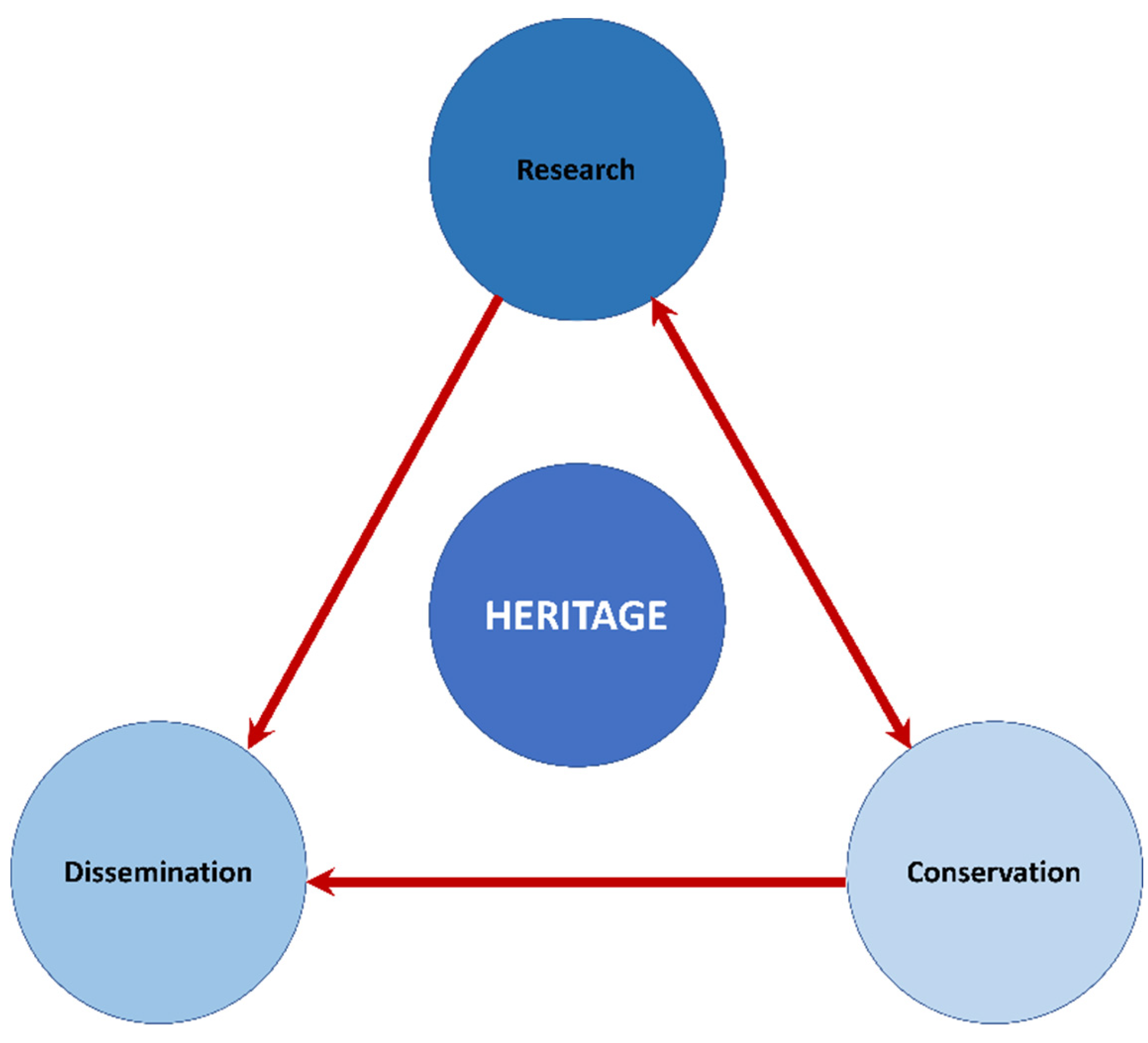
It is commonly accepted that heritage management rests on three fundamental pillars: research, conservation and dissemination (or education) [
13]. The inter-relational flows of these three key aspects of heritage are illustrated in
Figure 1. Until about 30 years ago, researchers, restoration experts and visitors could only work and/or feel the experience of heritage by the means of direct sensorial contact with the physical artefacts/structures. Nevertheless, virtual reality (VR) provides new ways to research [
14], restore [
15] and disseminate [
13] different kinds of heritage. In particular, VR has had a profound impact on dissemination. Today, visits to emblematic archaeological sites are very common and some of these now offer a double experience to users of VR: firstly, regarding the visit itself, which takes place using a product of real virtuality (RV) (e.g., the Lascaux IV neo-cave) and secondly, enhancing the experience with virtual reality (VR) tools (
https://www.lascaux.fr/en). This combination, far from being redundant, becomes very attractive for visitors because both experiences are complementary [
16]. In addition, the second application invites visitors to make their own decisions [
17]. This may be related with a question pointed out by D. Haraway several decades ago: “Another critical aspect of the social relations of the new technologies is the reformulation of expectations, culture, work (…)” [
18] (p. 518). Also, our progressive approach to a cyborg-type conditioning of (hybrids between humans and machines) [
18] implies that the use of these kinds of tools now lends, a fortiori, a more attractive experience to the public experiencing cultural heritage. Nevertheless, both VR and RV have to deal with objectives leading to resolve heritage questions that include, as we have said before, research, conservation and dissemination of scientific results. VR and RV are not, therefore, ends in themselves, but rather they are tools that contribute to a better understanding of the past [
19].
Immersive virtual reality (IRV) is a very successful tool that combines aspects of VR and RV. Following [
17] (p. 57), ‘immersive’ “…refers to the degree to which a virtual environment submerges the perceptual system of the user in computer-generated stimuli” becoming an extension of body and mind. IRV creates effects and perceptions that do not require previous knowledge of the users to enjoy experiences that open the doors of spaces, such as archaeological excavations, allowed only to professionals.
On the other hand, heritage contributes to local socioeconomic development [
20], a question that is especially relevant in low income regions. In this sense, it is worth noting that Orce is a small village located in the Huéscar Region of Spain (also known as the Altiplano of Granada) with a total of 1198 inhabitants [
21]. This number reflects the strong population decline after 1950, when there were 4466 inhabitants. Moreover, the disposable income in 2017 was 12,894 €, ranking 2757th out of 2897 municipalities of >1000 inhabitants in Spain (range of disposable income: 53,185–10,584 €) [
22]. Nevertheless, its Lower Pleistocene heritage makes Orce a place with good potential for the development of cultural tourism. Finally, the relationship between heritage and identity and even self-esteem constitutes another important issue [
23]. Identity and self-esteem are “something actively and continually recreated and negotiated as people, communities and institutions reinterpret, remember and reassess the meaning of the past in terms of the social, cultural and political needs of the present” [
23] (p. 83). To a certain extent, a community’s self-esteem depends on its place in history and the recognition of the others. Additionally, having an original experience that distinguishes Orce from other similar cultural products in the area can lead to an increase in the number of visitors. In general terms, these users choose to incorporate not only the archaeo-paleontological aspect into their heritage experience, but also a peculiar gastronomic offer and unique accommodation in cave-houses. In this sense, it is important to point out that all the businesses in Orce are managed by people who were born or live in the town. Therefore, the impact of the visits on the local economy is direct. The positive impact of new developments related to cultural heritage is very great in such sparsely populated areas with such a low income. An example is the Museo “Primeros Pobladores de Europa” ("First Settlers of Europe" museum) which increased the number of visits, especially from 2015, from the year the new building was opened (
Table 1).
1.1. The Orce Archaeological Zone
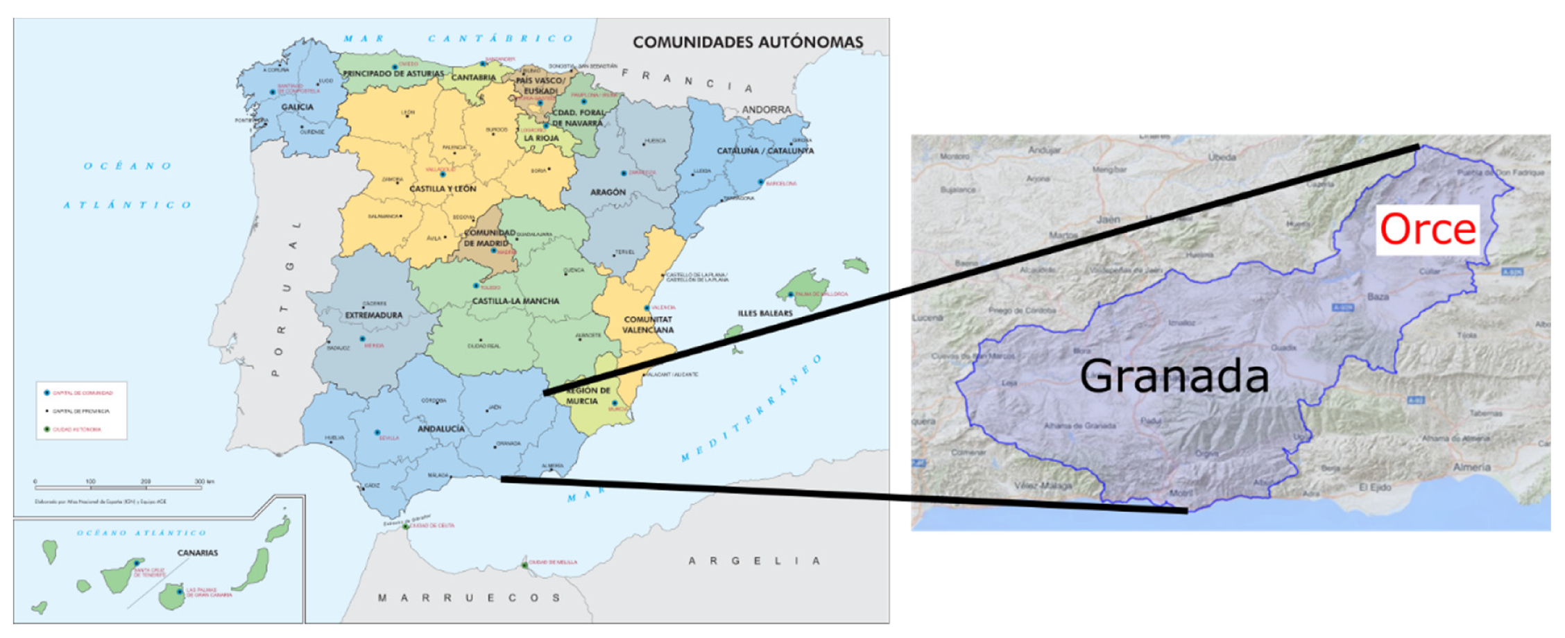
The Orce Archaeological Zone is located at the northeastern extremity of the Guadix-Baza Basin (
Figure 2). The extant landscape is dominated by deep gorges and ravines with a vegetation typical of arid climatic areas. However, the landscape was very different during the Lower Pleistocene due to the presence of a large lake that conditioned life in the Guadix-Baza Basin. The Orce Archaeological Zone presently encompasses at least 15 different Pleistocene localities that have yielded fossils of extinct mammals [
24]. Among these, three sites stand out for their richness in paleontological and archaeological heritage: Venta Micena (VM), Barranco León (BL) and Fuente Nueva 3 (FN3).
VM, an open-air paleontological site, is the oldest one of these. During excavations carried out in 1982, a small skull fragment (VM-0) was identified as human [
25]. Although subsequently this taxonomic attribution was challenged [
26], this removes nothing from the importance of the VM paleontological site, which remains emblematic for the European Lower Pleistocene [
27]. The VM site, dated to 1.6 Ma [
28], is well-known for the quantity and quality of the fossil record it contains, providing very complete remains of extinct mammals.
In 2002, the BL open-air archaeological site yielded a hominin deciduous lower molar, making it the oldest site in Europe with human remains [
29]. In addition, the BL site provides one of the richest Oldowan lithic tool assemblages presently known in Eurasia (2799 elements up to and including the 2019 field season) [
30,
31,
32]. In general terms, much of the lithic assemblage is comprised of large-sized used and knapped cobbles of Jurassic limestones. The assemblage also contains numerous smaller sized flint flakes and cores. Although the fossil remains are very fragmented, the macro-vertebrate assemblage from BL is very similar to that from VM and, especially, from the nearby site of FN3 (see below). The majority of the archaeological record was collected from sub-levels D1 (where the human tooth was discovered) and D2, dated to 1.4 Ma [
33].
1.2. A Closer Look to Fuente Nueva 3 Archaeological Site
FN3 is another open-air archaeo-paleontological site, located at the Orce Archaeological Zone (
Figure 2). The site was discovered coincidentally in 1991, during works undertaken to install an electrical line. Since then, FN3 has yielded one of the oldest and most significant Oldowan stone tool assemblages so far discovered outside of Africa.
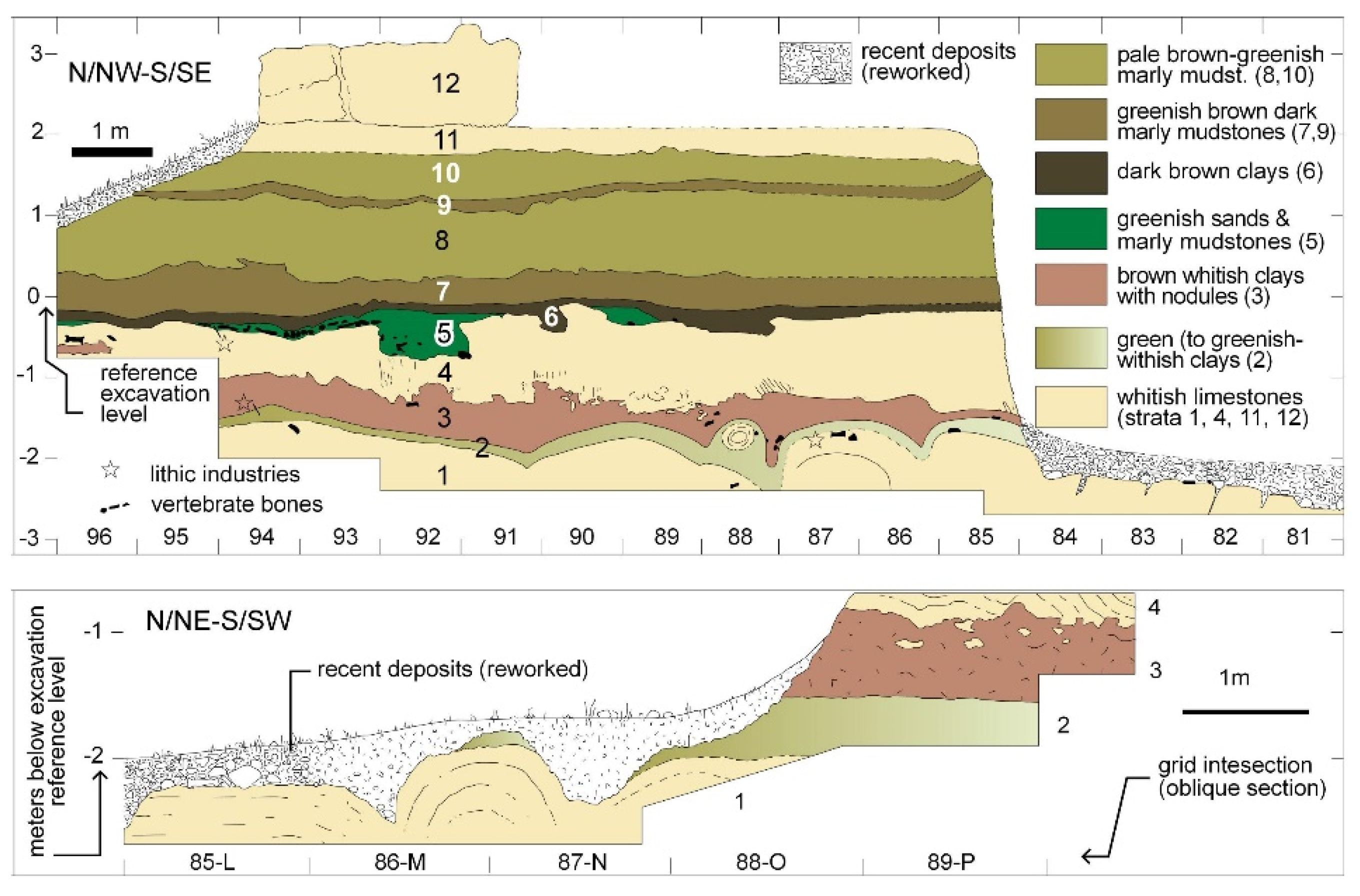
Two distinct archaeostratigraphic units compose the site’s depositional sequence: the Lower Unit (levels 1–4) and the Upper Unit (levels 5 to 12) [
34] (
Figure 3). Most of the archaeo-paleontological evidence comes from levels 3 and 5. In addition, the FN3 site has provided an age of 1.19 ± 0.21 Ma by the method of 230Th/234U [
33], in agreement with the paleomagnetic analysis and the biostratigraphic evaluations [
34,
35,
36]. From a lithological point of view, the predominant sedimentary materials are clays, mudstones and limestones (
Figure 3) [
34]. A geological fault revealed during ongoing excavations extends in an east-westerly direction along the site.
Following the latest revision of the lithic assemblage, the FN3 collection contains 1630 pieces made from local limestone and flint, all of which were collected from systematic excavations ongoing at the site since 1994 [
37,
38]. The FN3 toolkit is well-preserved overall, and its numerical significance is outstanding for this timeframe in Eurasia. These factors contribute to the fact that this assemblage provides a complete sample from which to evaluate the cognitive and technological capacities of the first inhabitants of Western Europe.
At FN3, Oldowan lithics are found associated with a rich faunal record. The complete list of large mammals is composed by the following taxa [
39]:
Order Carnivora
Lynx sp.
Felidae indet.
Pachycrocuta brevirostris
Lycaon lycaonoides
Canis mosbachensis
Vulpes cf. V. praeglacialis
Ursus sp.
Pannonictissp.
Meles meles
Mustelidae indet (small size)
Order Proboscidea
Order Perissodactyla
Order Artiodactyla
Additionally, FN3 provides a rich microvertebrate assemblage including: four amphibians, nine reptiles, one cyprind [
40], six rodents, two lagomorphs and five insectivores [
41].
Structurally, two different elements stand out in the FN3 site: a pair of exceptionally large-sized
M. meridionalis tusks (
Figure 4) and the (above-mentioned) geological fault. These two elements (which may be considered as pseudo-structures) are challenging the continuity of the excavation process. Taken together, the significance of the FN3 site and the presence of these two remarkable elements are the focus of the present paper, which aims (1) to reconstruct these two significant elements being an intrinsic part of the site; (2) to extend the reconstruction to include and visualize the entirety of the excavation surfaces of FN3; (3) to provide the most reliable measurements of the
M. meridionalis tusks, and (4) to create a video game (from VR to RV) as a tool to disseminate one of the most ancient site contexts with human presence presently known in Western Europe.
2. Materials and Methods
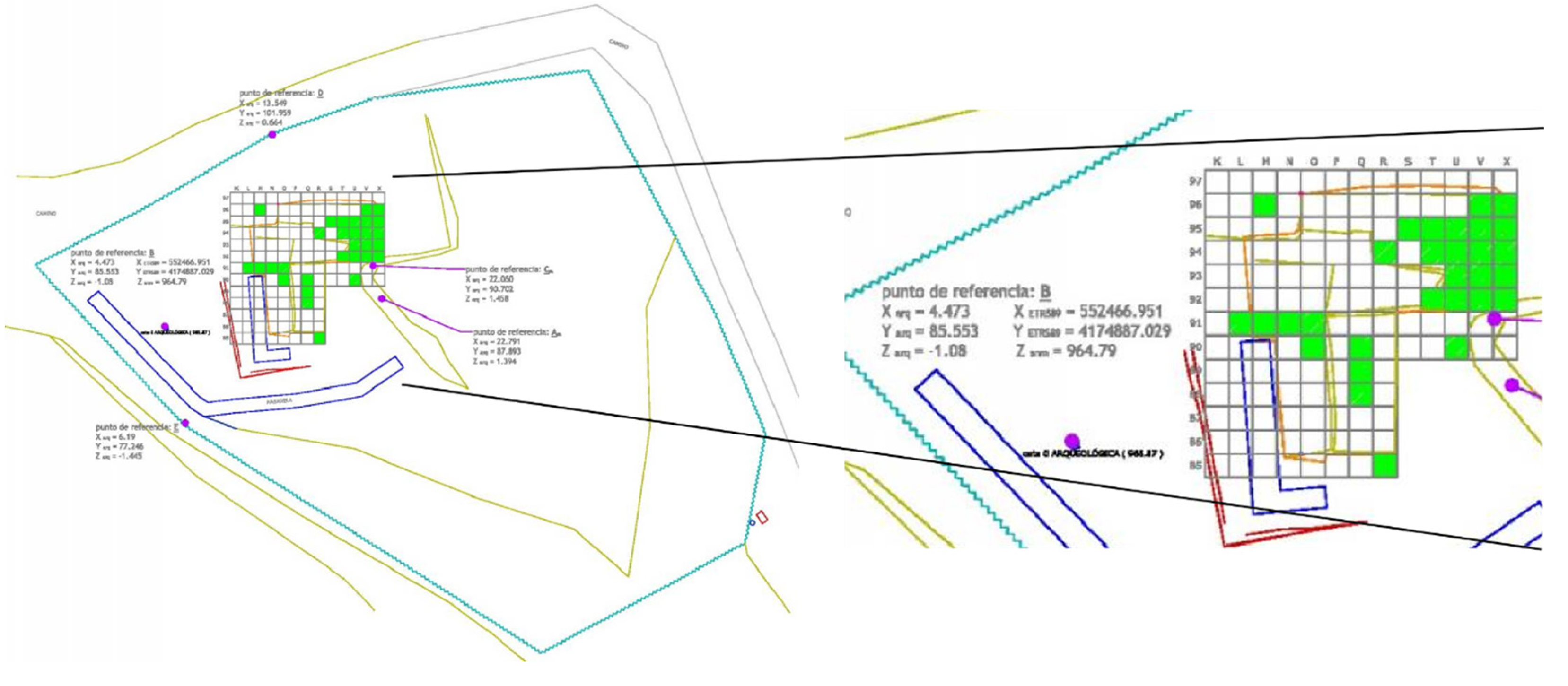
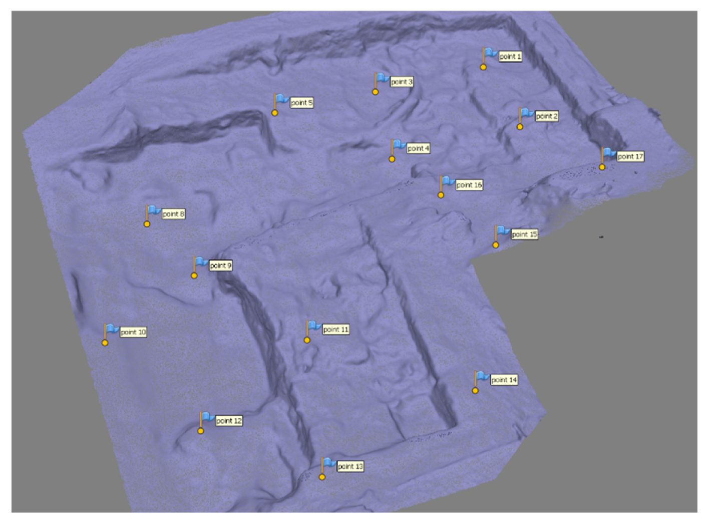
The FN3 site is geo-referenced in the Spanish official reference coordinate system ETRS89 UTM Zone 30, also expressed in a local coordinate system (LCS) where the origin (X = 0, Y = 0, Z = 0) is very close to the excavation area (
Figure 5). The LCS divides the excavation area into square-meters, where the X axis is denoted by letters and the Y axis by numbers (each in ascending order per 1 m squares). The present extension of the FN3 archaeological site is of 13 × 13 m (
Figure 5).
The surface from the excavation area has been modeled in 3D imagery and its corresponding texture is derived from a photogrammetric process, so that the resulting product provides a very detailed documentation from the site. This methodology was carried out during the 2017 and 2019 field seasons, and is planned to continue in the future, in order to generate a temporal series showing in 3D the evolution of the excavation according to the research project goals, specifically those related to the spatial relationships between human-made lithic tools and vertebrate fossil remains. The 3D textured model can also be used to create scenarios that include realistic environments in virtual, where both the public and the researchers can interact with the remains discovered during each excavation campaign.
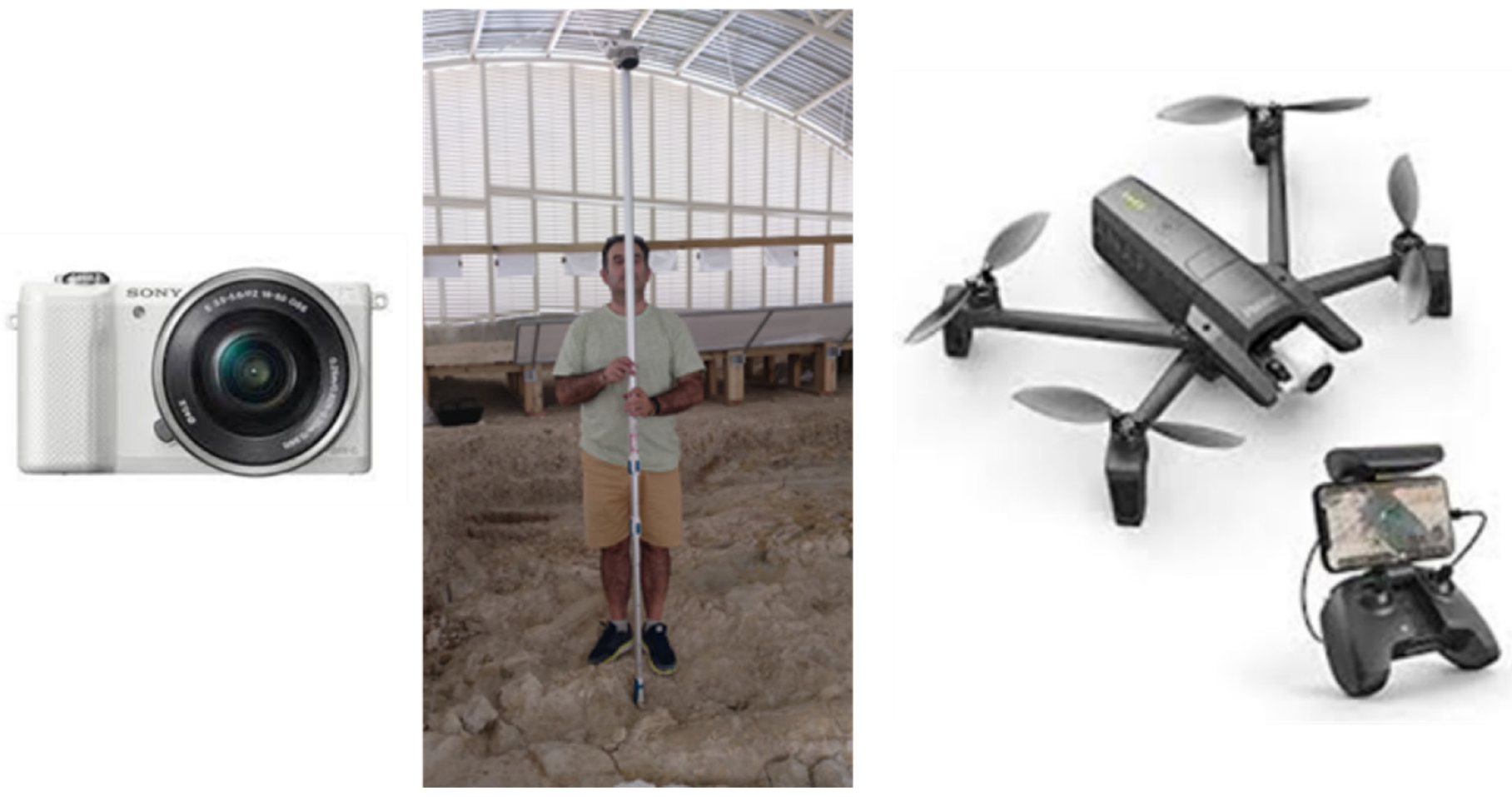
The photogrammetry was carried out using two different approaches for the campaigns 2017 and 2019. In 2017, we used a Sony Alpha 5000 camera suspended on a pole, in order to achieve a vertical image. From a heritage conservation point of view, this procedure was inconvenient because it required a person to tread on the excavation surface, thus risking to inadvertently damage some of the remains. For this reason, in 2019, we decided to perform the photography using a remotely piloted aerial system (RPAS) (Parrot Anafi). This micro aerial vehicle was small enough so that its air flow does not affect the surface of the excavation. The above-mentioned set of camera, pole and RPAS are shown in
Figure 6.
The camera features for the Sony camera, the Parrot Anafi on board, and the outstanding features for the RPAS are shown in
Table 2.
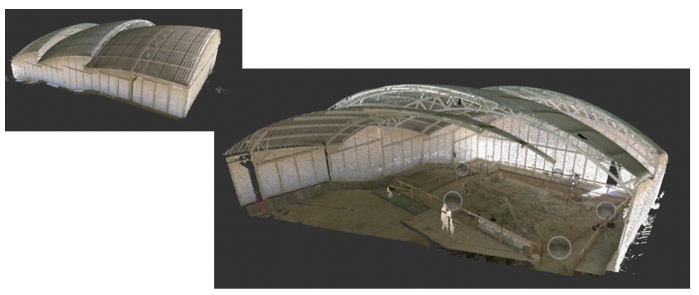
The FN3 archaeological site can be visited every day of the year because it is housed beneath a structural roof which protects it from weather conditions (
Figure 7). This roof was a handicap to our work because it impeded the RPAS from picking up a clear GNSS (Global Navigation Satellite System) signal and, consequently, two problems arose: (1) the RPAS was harder to pilot and (2) it was impossible to take the pictures in automatic mode [
43]. The latter problem was mitigated by means of the Extra-sensors mentioned in
Table 2, but the former problem forced us to take the images manually.
The number of pictures for building the 3D model (NP) in the 2017 season was 222, the mean distance from the camera to the ground (MCG) was 2.35 m and the number of control points measured in the field (NCP) was 15; in the 2019 season the NP was 393, the MCG was 2.48 m and the NCP was 14.
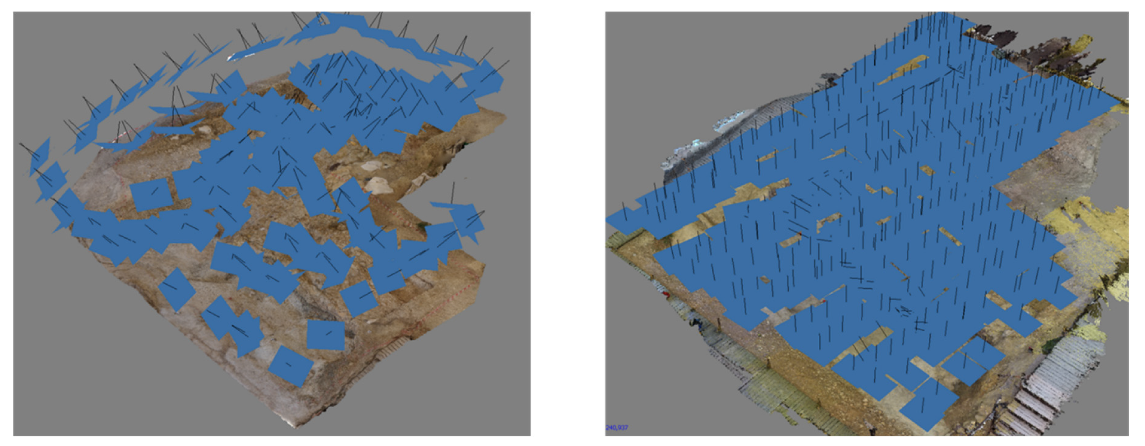
The image acquisition was not performed in automatic mode for either of the 2017 and 2019 field seasons was the imaging acquisition performed in automatic mode. The images taken in 2019 were produced with the RPAS, which allows a more homogeneous picture distribution because it uses a human pilot that tries to capture them at equal distances. Contrastingly, in 2017, image acquisition was carried out with a camera assembled onto a pole. Such a procedure was constrained, however, because those parts of the site with exposed fossils could not be stepped on. To solve this constraint, some pictures were taken in an oblique position, so that the image set was not distributed in a homogeneous way (
Figure 8).
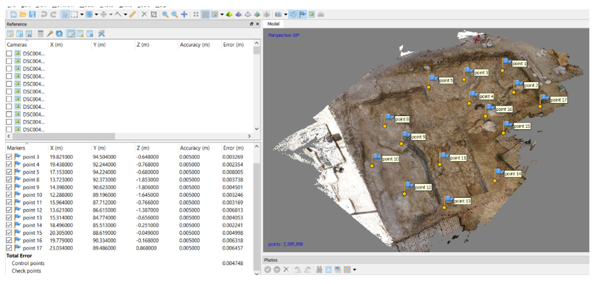
The relative orientation of the photographs shown in
Figure 8 was obtained using the photogrammetric alignment process: the absolute orientation (levelling and scaling as referred to the LCS) was achieved by assigning 3D coordinates to some targets (survey control points) all over the excavation area. The survey control points have been referenced using a Total Station Leica TS03, equipped with an angular accuracy of 3” and 1.5 mm ± 2 ppm in range. The mean error after fitting the images bundle in 2017 was 4.7 mm, as shown in
Figure 9. The software used in the photogrammetric process was Photoscan version 1.5.2 from the Agisoft company.
The 3D model was derived from the dense points cloud (
Figure 9), obtained after the alignment. The point cloud was triangulated and a mesh was derived (
Figure 10); in the 2017 field season, the number of points to be triangulated was 2,395,656. In order to make the most of the 3D model, a texture was projected onto the mesh, making it suitable to use as a scene to introduce in VR environments.
Because the 3D model to be included in the Unreal Engine should be as light as possible, we simplified the triangulated model from a lower dense cloud.
Table 3 shows the dense cloud and the number of triangulated faces for the high and simplified model.
Once the 3D model is complete, we can derive a series of products such as: ortho-images from the horizontal projection, elevation sections from some particular directions, 3D volumes from regions of interest and, as mentioned above, 3D scenes to include in VR environments.
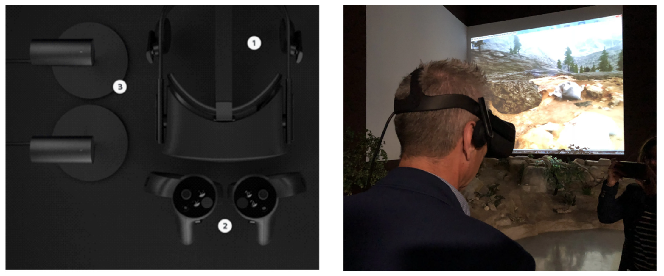
We also produced an immersive VR scenario based on the FN3 site contextual data. The software supporting our VR development was Unreal Engine. We used the visual programming environment offered by Unreal Engine, especially the blueprint templates that facilitated the production tasks. To include our 3D textured model in Unreal Engine, we had to simplify the mesh so that the computer was able to perform optimally. The solution that we implemented to navigate the FN3 scenario was first person, the blueprint and the head mounted device (number 1 in
Figure 11). The Oculus Rift system is suitable for room-scale concept performance (right image in
Figure 11), which consists of a player that can move physically inside a room within the limitations of the sensor’s maximum range (number 3 in
Figure 11). Our VR implementation was compatible with displacement just using the motion controllers (number 2 in
Figure 11). When people move the head mounted device, new 3D stereo images from the scenario appear on the head mounted device displays, enhancing the player’s immersive experience.
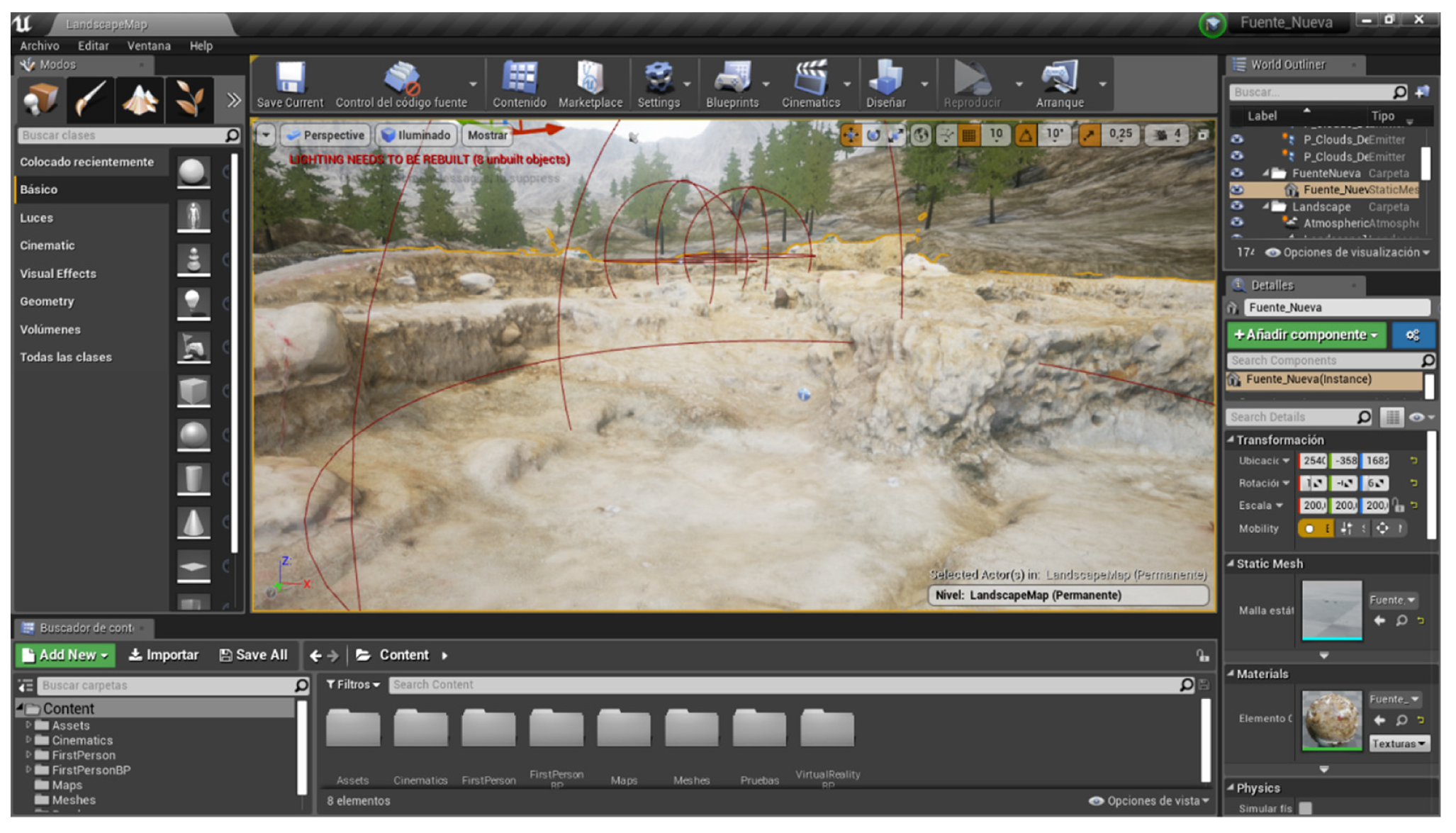
The Unreal Engine implementation also required a Pawn class that is the base class of all actors that can be controlled by players. A Pawn is the physical representation of a player within the virtual world. The player can determine what the Pawn looks like, but also how it interacts within the virtual world, in terms of collisions and other physical interactions. We integrated data from the FN3 archaeological site to create a landscape, including trees and other kinds of vegetation, in order to achieve a realistic immersive experience (
Figure 12).
3. Results
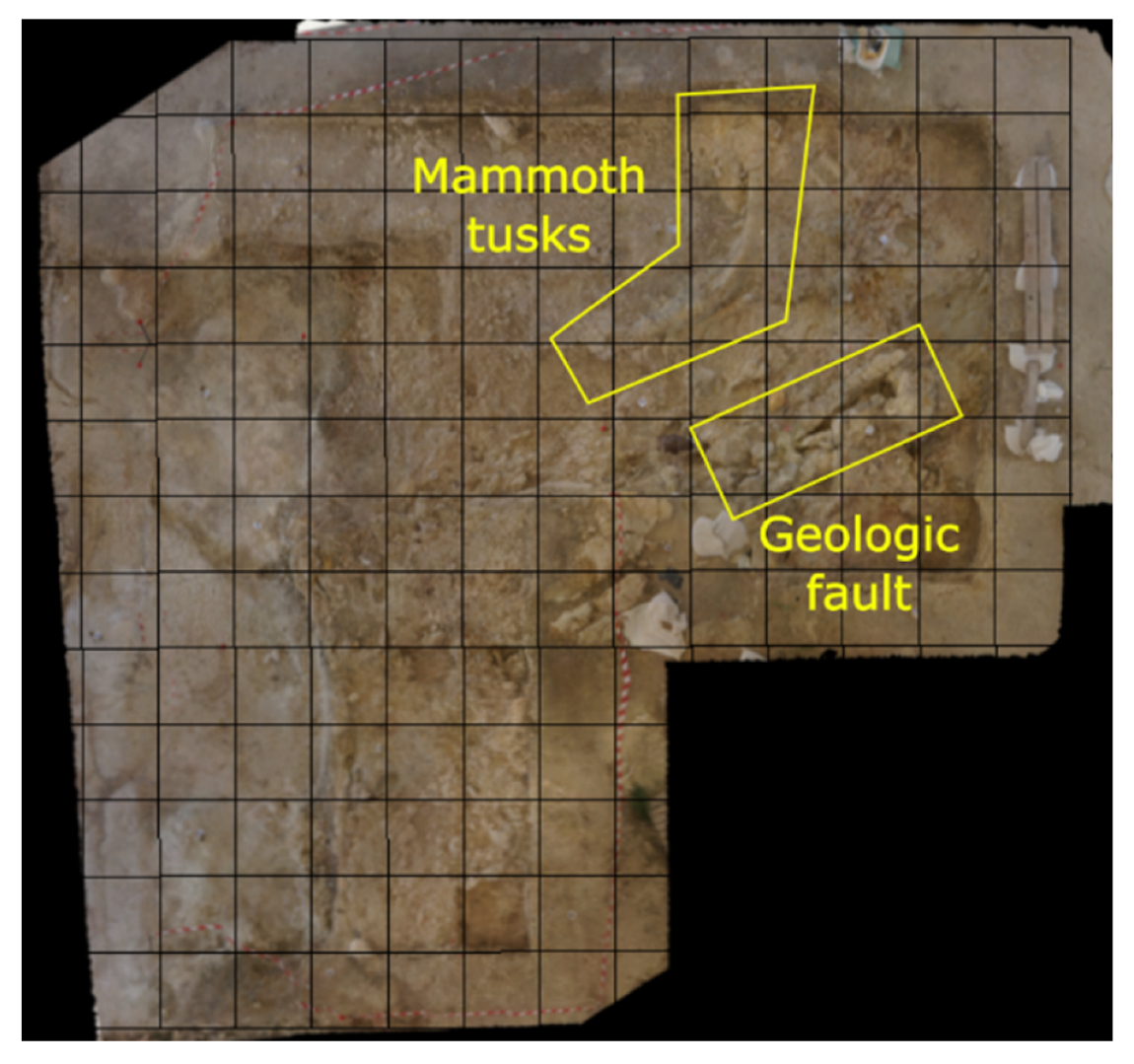
The 3D textured model obtained from the photogrammetry process allowed us to derive an ortho-image like the one shown in
Figure 13. The advantage of ortho-imagery is that we can take accurate dimensions measuring directly from them; if the images used in the alignment of the photogrammetric bundle are of good enough quality (i.e., sharp images and a small ground sample distance), then it is possible to reach high spatial resolution within the ortho-image. In our case, the default pixel size proposed by Photoscan for the ortho-image was 0.00067 m, which allows taking precise measurements for objects appearing in it. In
Figure 13, we also delineate the square-grid we established on the ground to support the digger’s task during the excavation period.
The 3D textured model, supported by a solid representation, proved to be an ideal asset for obtaining more precise 3D measurements and also to identify some structural properties that, in a single ortho-image, are not detectable. The solid representation is a mesh, shaded using a single color and showing directional shadows.
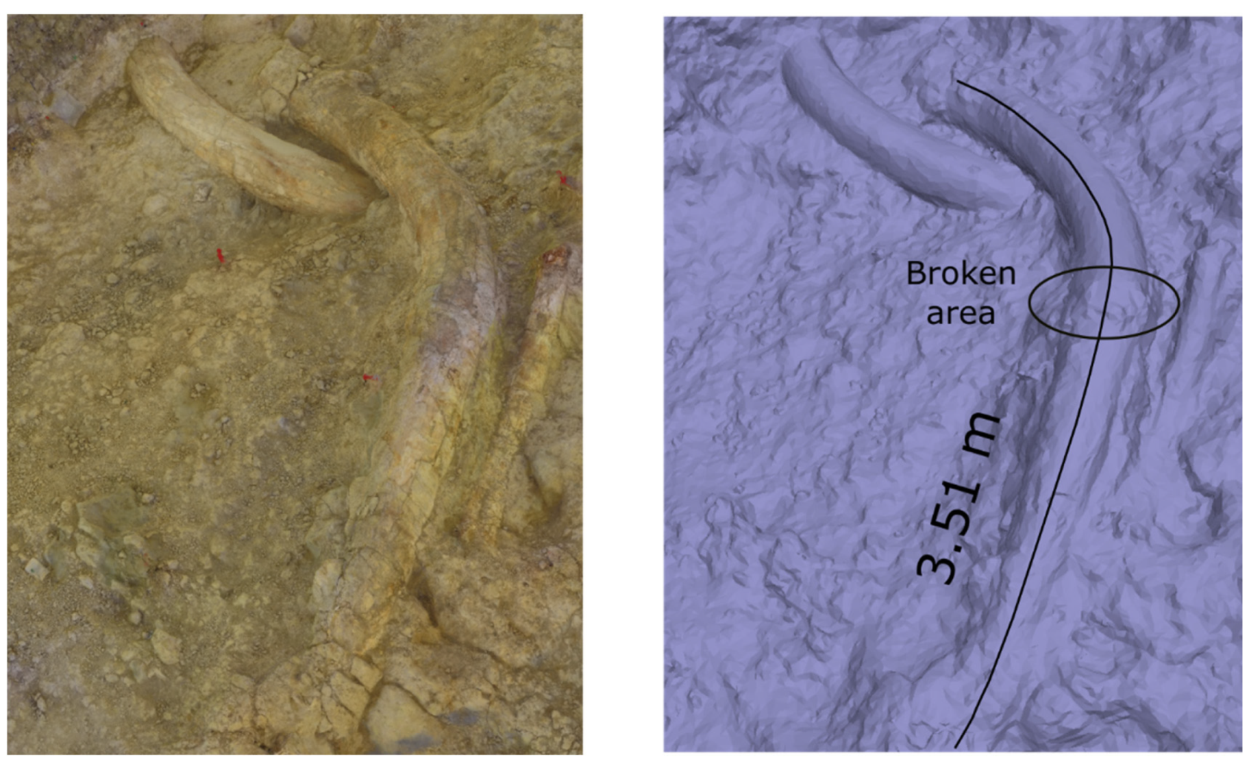
Figure 14 shows two mammoth tusks, one of which has been estimated to measure about 4 m long, although the visible part on the excavation surface displays only 3.51 m. It is possible to appreciate the quality of the 3D model, not only in the textured form, but also in the solid representation. In our case, the solid representation was particularly useful in identifying an area where the largest tusk was broken (
Figure 14).
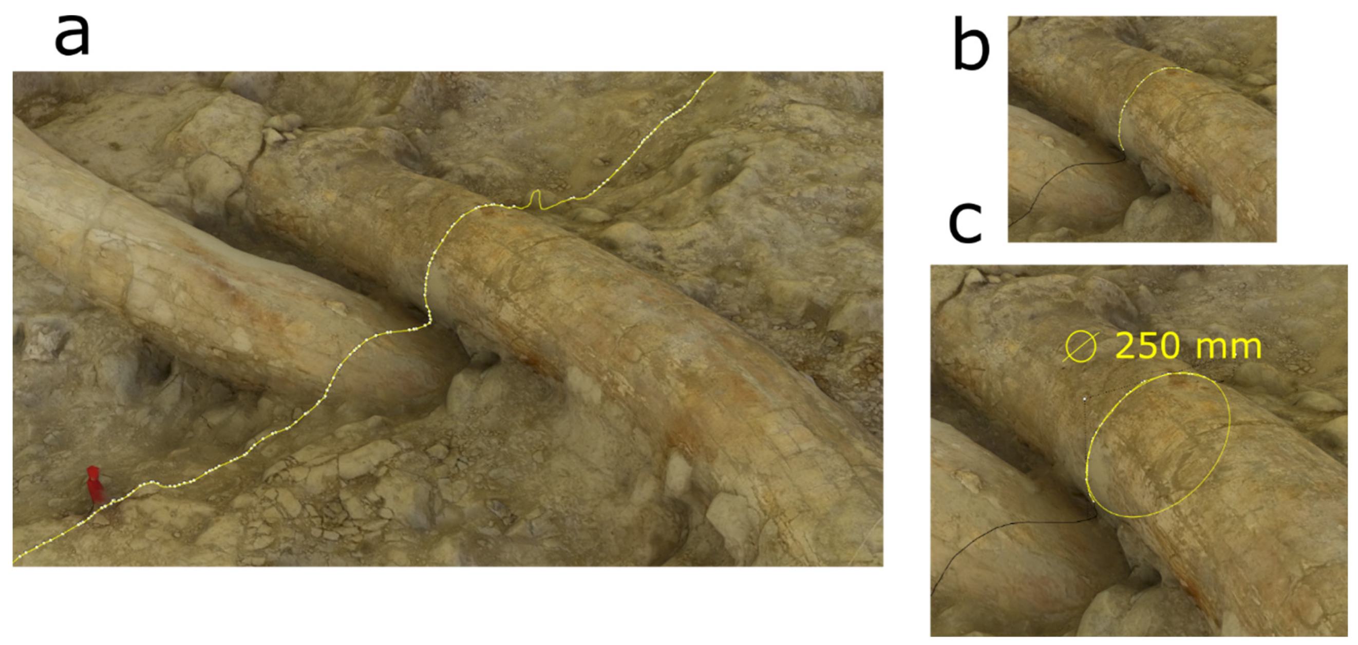
It is possible to obtain more accurate measurements from the mammoth tusks, such as their heterogeneous diameter from the base towards the tip. Because part of the tusk has not yet been excavated (only part of the tusk is exposed on the surface), we were able to estimate its diameter using least square fitting [
44]. To obtain the diameter in a particular area of the tusk, we made a section (intersection between a plane and the tusk), approximately perpendicular to the tusk axis. The resulting section is shown by the yellow polyline in
Figure 15, a. In order to get an approximated suitable circle adapted to the tusk sectioned, we segmented the polyline, keeping only the segments on the tusk surface (
Figure 15b). The circle fitted by a least squares approach can be observed in
Figure 15c, where the polyline segment of
Figure 15b is also superimposed. With this method, the value obtained for the diameter was 250 mm.
Therefore researchers can go further in their analysis, even without extracting objects from the archaeological context, obtaining more reliable measurements and establishing a better plan for future field seasons. In addition, the 3DVR of the FN3 site forecasts a high scientific potential for this technology, particularly in light of its ability to implement a database, where the analysis and relationship between remains can be shown in stereo imagery, so that spatial relationships have new potential to reveal information that would otherwise be difficult to detect.
Although FN3 cannot yet be visited freely, the newly constructed permanent metallic structure will allow, in a foreseeable future, a regular visiting schedule to be established. Nevertheless, visits to FN3 are very frequent as the Orce Archaeological Zone is included as field in practice programs for students from the Universities of Granada and Málaga and for other groups upon demand, and there are also numerous visitors during the excavation seasons thanks to the policy of the research team to maintain permanent open days. From the visitor’s perspective, it is very important to be convinced that the information being shared with them is of high quality. From our point of view, it is also crucial to disseminate not only accurate information, but also to share how we generate scientific data, thus imbuing the visitors with an additional grade of confidence.
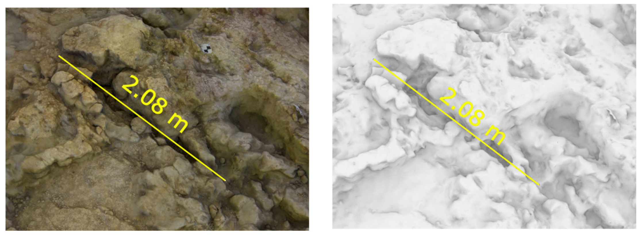
The other outstanding element presently visible in the FN3 excavation area is a geological fault, whose azimuth is 237.5° and whose length is 2.08 m (
Figure 16). This geological accident conditions the progress of the excavation, making it difficult to work in the area surrounding the fault without risking the collapse of the affected deposits.
The 3D textured model provided the foundation upon which to build a scenario where a person wearing a head mounted device (e.g., Oculus Rift) can navigate the archaeological site in an immersive virtual reality (IVR) experience, either walking in a room to scale, or using the motion controller to navigate from one place to another, both inside the excavation area and in the extended landscape surrounding the site, built in Unreal Engine. This virtual reality scenario has been tested by several people in the Archaeological and Paleontological Museum of Orce and also by the general public during the European Researchers’ Night at Granada (2018 and 2019 Editions).
This work has generated an impulse in the socialization of the fieldwork process through the sharing of findings unearthed by the Orce Research Project; specifically at the FN3 site. Through this socialization approach, the public can access an immersive experience in the singular archaeo-paleontological site of FN3, considered as one of the most significant ancient human settlements in all of Europe [
35]. Furthermore, this aspect increases the democratization of scientific knowledge and applies social integration policies enabled by this tool, making it available to people with functional disabilities, specifically those with limited mobility [
5]. It also makes it possible to disseminate scientific knowledge amongst confined individuals (e.g., being a part of the educational and reintegration policy aimed at prison populations).
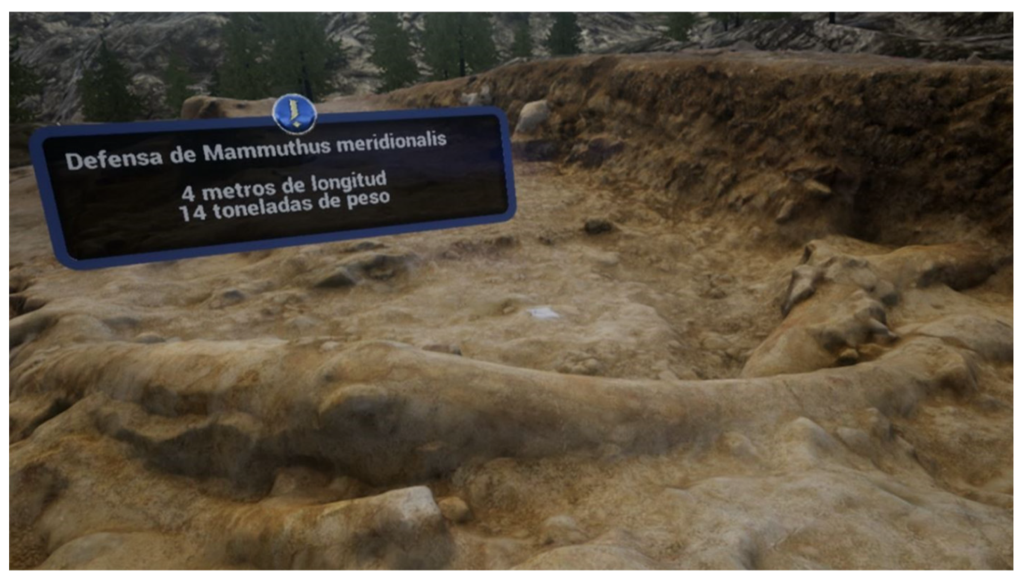
Still another advantage is that the public can ‘walk among mammoths’ without incurring any damage to this unique archaeo-paleontological heritage. People can approach and observe a re-creation of the archaeological remains in an even higher level of detail than if they were observing the site from the visitor’s balcony or surrounding walkway it and thus experience a sensation similar to that of the archaeologists themselves. In addition, the VR engine (in our case: Unreal Engine) facilitates the display and understanding of important data in order to guide the VR tour over the excavation. In this case, the audience can see an informative signboard indicating highlighted information (
Figure 17).
Yet another benefit we highlight here is the quality of the experience itself, which has already gained appreciation among the people that have participated in it, who have acknowledged the high-quality perception they had of the FN3 site using the IVR.
The last advantage we wish to underline is related to the use of the 3DRV as an advertising tool to motivate users to visit the Orce Museum and also the FN3 site. This aspect is especially important since Orce is located in a region of Spain known as ‘the Altiplano’, which has relatively low socio-economic development rates. In fact, the Altiplano is one of the areas known as “the emptied rural Spain”. From this point of view, this technology, newly applied to a specific heritage site, can become a stimulating factor for economic and social development.
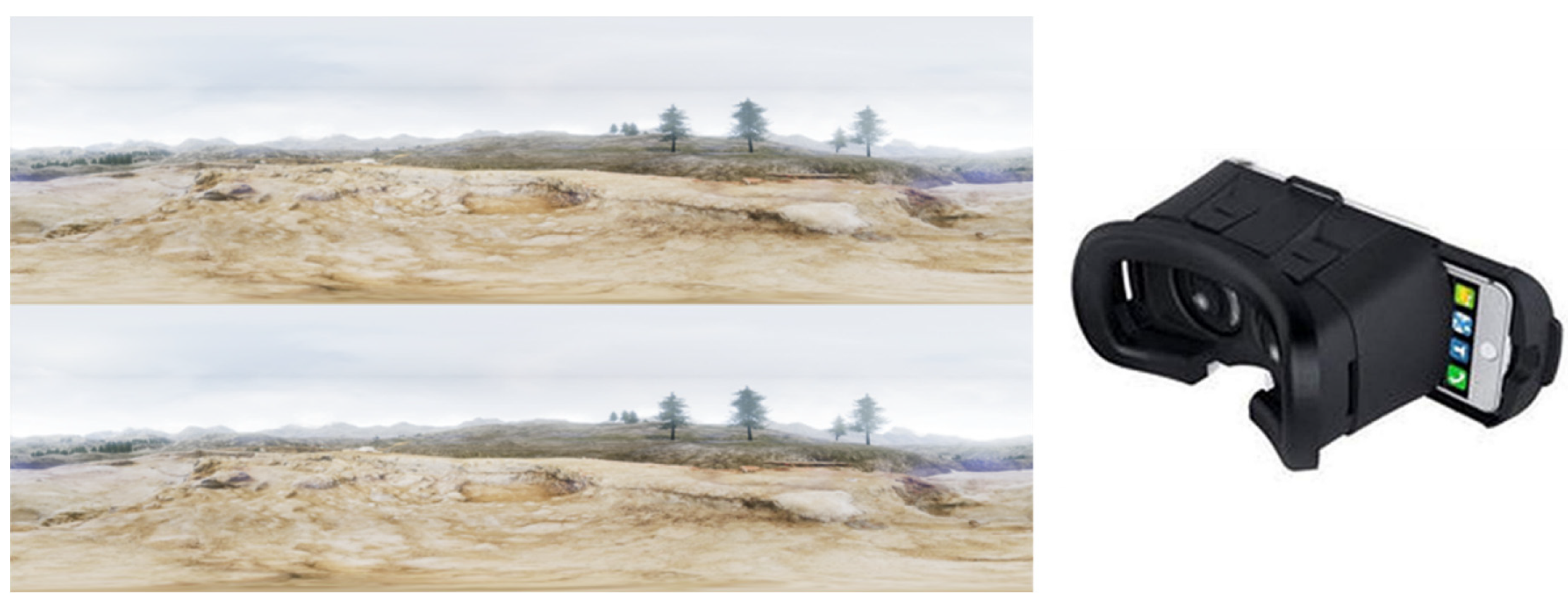
Nevertheless, a head mounted device for VR remains costly for most people (e.g., that shown in
Figure 11). For this reason, and in order to disseminate the 3DVR of the FN3 excavation surface, we produced several stereo panoramic images (left-side image in
Figure 18) derived from our 3D model scenario, which can be observed using significantly cheaper cardboard glasses (left image on
Figure 18).
The stereo perception and immersive experience is achieved by splitting the smartphone display into left and right images that correspond, respectively, to the upper and lower panorama images (
Figure 18), and then inserting the smartphone in the cardboard glasses (
Figure 18).
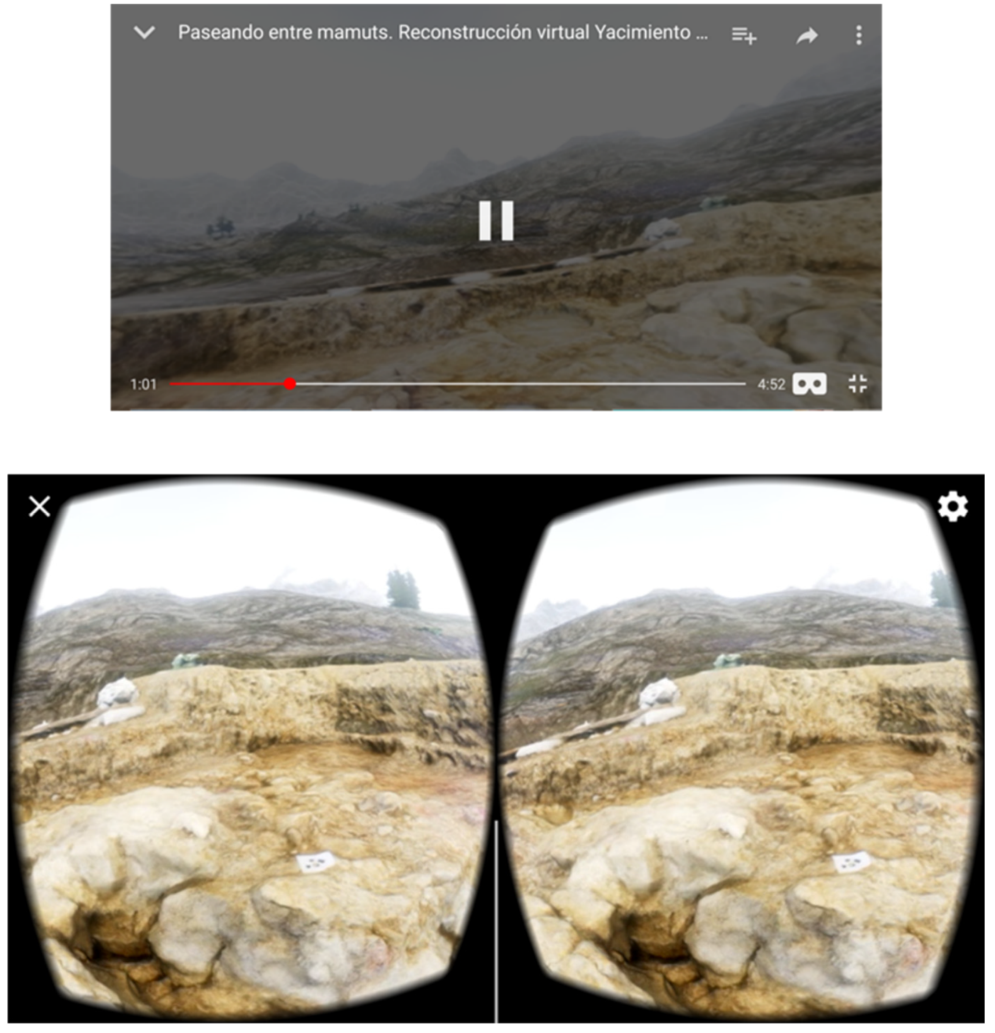
The stereo panorama images are hosted on a Youtube channel (
https://www.youtube.com/watch?v=BbWUHlRSn7k). The requirements for a correct visualization are cardboard glasses and a smartphone equipped with a gyroscope (a sensor that it is included in the most of the recent smartphones). The interface is provided by Youtube (upper image in
Figure 19). Users only need to select the glasses icon in the right bottom corner to obtain the split display (bottom image in
Figure 19).
From a methodological point of view, image acquisition in FN3 implies a combination of enough good quality images and suitable preservation of the fossil assemblage exposed over the site’s surface area. The Sony Alpha 5000 camera suspended on a pole provided sharper images than the camera on board the drone, because the sensor size is larger in the Sony camera than in the drone camera. As explained above, we used the pole because it is not possible to walk over the whole FN3 site, especially the area containing and surrounding the tusks. The disadvantage of the camera hung on the pole is that the pictures are not spatially positioned in a homogenous way, grouping a few images in a small space and lacking imagery from other spaces (left image in
Figure 8). As a result, some parts of the site have lesser coverage and some empty areas arise in the 3D terrain mesh derived from the point cloud. On the contrary, the use of the small drone allows to us overcome the challenge of on-site circulation, rendering more homogeneous images and spatial image distribution (right image in
Figure 8). This allows to eliminate the appearance of holes in the terrain mesh. The control point error for both camera in pole (0.0047 m) and drone (0.0018 m) are very similar and a little bit better for the drone than for the camera in pole. The inclination related to the vertical direction is higher in the camera in pole (37.92°) than using the drone (12.88°) capture; this higher inclination may explain some small blurred textured areas in the 2017 season that does not occur in the 2019 season. Evaluating both procedures, we recommend the second method (drone-based) because it offers more advantages (heritage preservation, acquisition time, elimination of holes in the terrain mesh) than disadvantages (connection difficulties due to the presence of a metal protective structure). In addition, the image sharpness achieved by the drone camera is adequate for an accurate 3DVR.
4. Conclusions
Documentation is a key function in any archaeological site, ensuring that a maximum of data can be analysed multiple times into the future. The remote sensing techniques play an important role in carrying out suitable documentation, particularly in the realistic 3D modelling of a site. The photogrammetry involved in the 3D model production guaranties an accurate positioning of the remains. The ortho-image is one of the most useful photogrammetric products, which allows for taking accurate measurements thanks to the high level of detail obtained in the imagery.
From a methodological point of view, we recommend the use of small drones to acquire images in mid-sized open-air sites containing exposed and fragile elements (such as large fossil remains). At this time, the only disadvantage is the sensor size. Nevertheless, the sharpness provided by the drone sensor size camera is sufficient to guarantee an accurate reconstruction.
Some partially exposed remains cannot be immediately extracted from the site and may even need to remain in situ for long periods of time, as in the case of the mammoth tusks in FN3, but our methodologies allow us to calculate some of their morphometric features, supported by the 3D model derived from the photogrammetry. Sections performed on planes of interest allow fitting curves and surfaces that inform us about the shape and size of some hidden parts of the remains. In some archaeological sites, as in FN3, there may be some geological formations or structures of interest, such as the geological fault described here. Such features can be perfectly documented using photogrammetric techniques.
The 3D textured model derived from photogrammetry is suitable to include in a virtual reality scenario to reproduce the original landscape surrounding the archaeological site. The virtual reality experience achieved by the head mounted device (in our case Oculus Rift) provides four main advantages: (1) it is ideal for diffusion of contents in an attractive presentation (stereo visualization and realistic immersion feeling); (2) it is possible observe a high level of detail along the navigation experience without any damage to the remains by providing a virtual tour of the site: the public (users) can observe details that they would be unable to see in an in situ visit to the site; (3) this technology makes it possible to convert an archaeological site into portable heritage, extending the visiting capacity to vulnerable groups, specifically those with reduced mobility and/or under confinement; and (4) immersive real virtuality should acts as an incentive to increase the number of people interested in visiting the Pleistocene heritage in Orce, contributing to the economic development and local identity.

 ,
, 


