1. Introduction
The concept of sustainability was brought to the forefront by the World Commission on Environment and Development (WCED) held in 1987, and, since then, it has been commonly applied to the whole variety of resources exploited by human society, including groundwater. In fact, the European Water Framework Directive, enacted in December 2000, establishes that it is necessary to promote a sustainable water use. While there is a general consensus on this basic principle, its practical application in natural resource management is daunting [
1]. Although the concept of sustainability has traditionally been based on 3 basic pillars (social, economic and environmental), its definition depends on the context, and its dimensions are still under discussion. This point of view is endorsed by numerous authors: Sophocleous (2000) [
2] describes sustainability as a dynamic concept that has yet to be redefined and translated into feasible policies; Shamir (2000) [
3] claims that the concept of sustainability is integrated by up to 10 dimensions, that include hydrology, ecology, politics, economy and inter/intragenerational aspects, among others; Mays (2007) [
4] asserts that “because water impacts so many aspects of our existence, there are many facets that must be considered in water resources sustainability”. The present work is going to focus mainly on the hydrological aspects of groundwater sustainability, following the criteria established by the U.S. Geological Survey, which defined this concept as the “development and use of groundwater in a manner that can be maintained for an indefinite time without causing unacceptable environmental, economic, or social consequences” [
5]. In this regard, it must be noted the intergenerational perspective inherent to this concept, which, in the words of Sophocleous (2000) [
2], implies that “water resources must be used in ways that are compatible with maintaining them for future generations, thus constraining our management of water”.
Groundwater constitutes the main and safest source of water, supplying numerous urban and rural communities and their associated economic sectors, especially in areas of arid and semi-arid climate where surface resources are available intermittently and seasonally [
6]. Besides, groundwater is a valuable strategic reserve, considering the uncertainty posed by climate change regarding the availability of water resources in the medium and long term. From a hydrologic perspective, the sustainable exploitation of aquifers was commonly understood as the adjustment of withdrawals to recharge, which implied an intrinsic consideration of groundwater as a renewable resource. Nevertheless, this conception is an oversimplification of the hydrogeological systems. To achieve a thorough understanding of groundwater bodies (GWB) and their functioning, it is necessary to have a global vision of the hydrological cycle. This is because the depletion of the water table (WT) of an aquifer subject to pumping can lead to alterations that not only affect the discharge areas (springs, wetlands and groundwater-dependent ecosystems), but can also impact the quantity and quality of river flows, and even reverse the river-aquifer hydraulic interactions.
Great progress has been made in the field of groundwater management and protection since the last decade of the 20th century, but there are still important problems specific to each site and hydrogeological system that the water authorities and public institutions must address [
7]. Despite the numerous competences legally attributed to the administrations, in practice, their efforts fall short of guaranteeing an effective control and monitoring of the status and exploitation of GWB. This situation is the result of several factors, such as the poor knowledge of hydrogeological systems, the lack of material and human resources, the existence of inherited regulatory figures that hinder a sound management of the resource or the lack of guidance for farmers and landowners regarding the efficient use and protection of groundwater. In addition, it must be considered that the adoption of excessively restrictive measures by the administrations may lead to social conflicts. In line with this, Galloway & Pentland (2003) [
8] claim that the administrative implementation of groundwater management objectives must rely on the science of hydrology and that an improved scientific understanding of the groundwater systems can also reduce management uncertainties and enhance the beneficial use of the resource.
All these considerations evidence that dealing with the multiple problems concerning groundwater requires a multidisciplinary approach that combines geological, hydrogeological, historical and social aspects to build up a detailed picture of the system.
This multidisciplinary approach has been endorsed by numerous works that, despite being focused on the field of hydrology, display a marked integrative vocation. Custodio et al. (2016) [
9] reviewed hydrogeological, environmental, legal, administrative, economic and social aspects of groundwater exploitation in Gran Canarias and Tenerife. Molina et al. (2009) [
10] and Molina et al. (2010) [
11] applied the concept of Integrated Water Resource Management (IWRM) to aquifers in the province of Murcia incorporating the aforementioned aspects in Bayesian network models. Melloul and Collin [
12] proposed an integrated hierarchy of hydrological aspects, land uses and social needs to achieve a sustainable use of water. Gleeson et al. (2012) [
13] focused on the most sociological aspects of water management and advocated the pursuit of multi-generational sustainability goals and the implementation of adaptive management and backcasting methodologies. Gondwe et al. [
14] conducted a multidisciplinary research combining piezometric measurements with geochemistry, geophysics and remote sensing techniques to study the karstic systems of the Yucatan Peninsula and promote the sound management of its resources.
Following this multidisciplinary approach, this study provides a comprehensive vision of the Benalup groundwater body (GWB 062.014), located in the province of Cádiz (Andalusia, Spain). On the one hand, geological, hydrogeological and geophysical techniques and laboratory tests were used to obtain information on the properties, spatial configuration and dominant structures controlling the functioning of the hydrogeological system. On the other hand, hydrochemical determinations were carried out to evaluate its qualitative status, which is closely linked to management practices and the functioning of the system itself. Finally, in order to provide further knowledge of water usage, remote sensing and citizen participation tools were implemented in the study area. The first was aimed at monitoring the evolution and distribution of irrigated crops (useful to quantify the exploitation of aquifers) and the latter at assessing the citizens’ knowledge and perception regarding the local water resources. A brief revision of the administrative and socioeconomic scenario is also provided. Merging all this information enabled us to identify weaknesses and set guidelines for the sustainable management of groundwater. In this case study, the chemical and quantitative problems of the aquifer are mainly linked to the agro-livestock activity developed in the area and indirectly to the current social and administrative circumstances. In this regard, it is noteworthy that these problems are shared by 9 of the 14 (64%) GWB defined in the province of Cádiz by the regional government of Andalusia [
15], all of them presenting similar hydrogeological characteristics. Thus, this paper presents the lessons learned from the case of the Benalup aquifer, which are applicable to other systems, as well as alternatives and considerations aimed at the sustainable use of the resource.
2. Case Study
The Benalup aquifer is located in the mid-western sector of the hydrographic basin of the Barbate River, in the region known as “La Janda” (province of Cadiz), near the Strait of Gibraltar (
Figure 1). In administrative terms, this region belongs to the Guadalete-Barbate Hydrographic Demarcation. The aquifer studied has an area of 33 km
2 and encompasses the whole groundwater body Benalup (GWB 062.014), which extends across the municipalities of Medina Sidonia, Benalup and Vejer de la Frontera. In geological terms, the Benalup aquifer consists of Neogene and Quaternary detrital materials of considerable interest from a hydrogeological point of view. Owing to its location and characteristics, the aquifer constitutes a natural reservoir of great local importance for human and agro-livestock supply.
The hydrographic basin that encompasses the Benalup aquifer has a Mediterranean climate with oceanic influence according to the Köppen-Geiger classification. The precipitation regime presents a marked seasonal character, with an average precipitation over the basin that exceeds 820 mm/year and concentrates mainly between November and March. The potential evapotranspiration (PET) reaches 930 mm/year, of which 77% takes place between May and October (UCA, 2019) [
16], which conditions the irrigation water demand.
The productive model of La Janda region has traditionally been based on agriculture and livestock farming, while the industrial activity is almost inexistent. In particular, irrigated agriculture is of major importance and covers a surface of 15.000 ha, supplied with both surface water (84%) and groundwater (16%). Surface water comes from the Barbate, Celemín and Almodóvar reservoirs (joint capacity of 277 hm3), which are exploited to supply mainly irrigation. The groundwater resources in La Janda region come from the Barbate GWB (GWB 062.013) and the aforementioned Benalup GWB (joint extension of 145 km2); both aquifers display similar characteristics and are subject to intense exploitation. While the surface resources are managed in a planned and coordinated manner by a Water User Association (WUA), groundwater lacks an entity responsible for its control. This absence of a management entity responsible for the groundwater resources has led to an unplanned and uncontrolled exploitation of the aquifer.
Thus, the Benalup aquifer is exploited through several hundreds of boreholes, many of them of illegal character and without administrative authorization. Moreover, despite the efforts made by the administration to control the withdrawals, most of the large-flow boreholes are not equipped with water flow-meters or devices to control the operation time. The Benalup aquifer is exploited to serve two purposes: Firstly, to supply drinking water and secondly, for irrigation. This GWB supplies around 10.000 inhabitants distributed by several urban settings; Benalup, the most important (6.929 inhabitants, eastern sector of the aquifer), and other small settings of minor importance; Badalejos, Malcocinado (northern sector), Cantarranas (southern sector) and Naveros (outside the aquifer boundaries), whose annual consumption is about 0.85 hm3/year (20% of the total extractions). To ensure this supply, there are seven boreholes operating in different sectors of the aquifer, which are managed by either the city council or specialized water companies. However, the transfer of surface water from the adjacent Guadalete river basin began in 2019, managed by the entity “Consorcio de Aguas de la Zona Gaditana”. This water aimed at human consumption represents today ¼ of the urban demand previously covered with groundwater, but its proportion will gradually increase, so that exploitation for this purpose will become less important. Moreover, we should also mention the existence of important recreational facilities, with a golf course of about 50 ha and two equestrian facilities.
Agricultural pumping is carried out to irrigate the plots and farms located on the aquifer, being the only available source for this purpose. The authorized irrigated area within the aquifer is 785 ha, which represents 24% of the total surface of the system. The most commonly grown crops are potato and sweet potato, sunflower, carrot, leek, citrus and pasture for feeding cattle. The number of boreholes, the volume extracted and the actual irrigated area are difficult to determine. While many agricultural boreholes are no longer operating, owing to farm abandonment, other wells/boreholes with lower flow have been dug to supply second residences, which are used during the weekends or holidays and are usually linked to illegal land use. The area affected by these changes is more than 140 ha, with an average occupation between 20% and 30%. Indeed, in the framework of the present study, a total of 384 plots of this type and around 300–400 inhabitant-equivalent have been estimated. While urban areas have a sanitation network and purification and/or discharge systems to the river network outside the limits of the aquifer, many of the second residences lack wastewater collection systems, constituting potential sources of contamination. However, their effect is considered of minor importance compared to the agricultural diffuse pollution.
In summary, groundwater in the Benalup aquifer is extracted by individuals in an unplanned and uncoordinated manner, under poor administrative control. Moreover, the fact that some of the farms are covered by the 1879 Water Act and included in a “Catalogue of Private Waters” is another factor contributing to this chaotic situation. This uncontrolled exploitation has had detrimental chemical and quantitative effects on the aquifers. In fact, the Benalup aquifer was declared to have a poor quantitative and chemical status in the Hydrological Planning documents [
15], which demand the adoption of measures to reverse this situation and achieve a sustainable use of the resource in the medium term. The poor quantitative status was declared because the rate of water extraction exceeded the limits set by the current legislation. The poor chemical status responds to the evidence of nitrate contamination linked to agricultural activities.
3. Administrative and Socioeconomic Framework
In southern Spain, as in other semi-arid and Mediterranean countries, the intensive exploitation of groundwater since the second half of the 20th century has given rise to what has been called a silent revolution, whose main beneficiary has been the sector of irrigated agriculture [
17,
18]. This phenomenon has contributed not only to achieve food security in the country, but also to a profound impact in micro and macroeconomic terms due to the important interrelationships of irrigated agriculture with other sectors of the economy. Likewise, groundwater exploitation has been fundamental for the development and consolidation of the population in rural areas. In Andalusia, the productivity of irrigated crops based on the exploitation of groundwater is remarkably higher than that obtained in crops that use surface water. Furthermore, farmlands based on groundwater exploitation create 3 times more employment per m
3 of water used [
19]. This higher productivity can be explained, firstly, because water is extracted at the point of use, without transport over long distances, and secondly, because farmers can use it “on demand”, maximizing its efficiency by reducing the energy costs derived from pumping [
20].
However, this silent revolution has traditionally been developed without an effective control by the Hydraulic Administration, hindering the adequate management of groundwater [
21] and resulting in impacts of different natures on aquifers. In line with what was stated above, the legal status of groundwater in Spain has undergone a significant evolution in recent decades, with numerous laws and doctrinal opinions related to the social, political and economic conflicts of the moment. Until 1985, the regulatory regime of groundwater was comprised in two norms: The 1879 Water Act and the Civil Code, which recognized the right to exploit groundwater as a consequence of land ownership [
22], enabling the extraction of the resource without administrative requisites.
More than a century later, the enactment of the Water Act of 1985 was a turning point that changed the legal regime of water decisively. In the first place, it proclaimed the inclusion of groundwater in the public domain and suppressed the right to appropriate this resource through wells and galleries. Secondly, it conferred to the River Basin Agencies (Hydrographic Confederations), which belong to the State Administration, the competence for managing groundwater and granting authorizations and concessions for its exploitation. These Hydrographic Confederations are also responsible for the inspection and monitoring of the water resources, for the enforcement of the conditions set by the authorizations and for carrying out plans, programs and actions to promote water saving and an efficient use of the resource in economic and environmental terms. In the case of those hydrographic basins that belong entirely to an Autonomous Region, such as Andalusia, the competences attributed to the Hydrographic Confederations would be transferred to the Autonomous Government (Junta de Andalucía) through the corresponding organisms. They would also keep a Registry of Public Waters and would be responsible for declaring aquifers as over-exploited, having to formulate management plans aimed at their recovery.
The radical change in water ownership introduced by the Water Act of 1985 meant that the new regime had to be made compatible with the rights acquired by owners with the previous law. To achieve this, the law considered two possibilities: (i) that groundwater owners could benefit from the resource for 75 additional years, by virtue of administrative concessions or authorizations for the occupation or use of the public domain, or (ii) in a 3-year deadline, owners who did not have the corresponding administrative authorization had to regularize their situation by registering in a Catalogue of Private Waters [
23]. Nowadays, the legal regime of groundwater is set up by the Act 10/2001 concerning the National Hydrological Plan, which emphasizes the role of users in water management, and by the European Directive 2000/60/EC (Water Framework Directive). However, after more than two decades, the groundwater situation remains chaotic; both the Water Registry of Public Waters and the Catalogue of Private Water are considerably incomplete, and hundreds of thousands of new wells and boreholes have been dug since the Water Law of 1985 without the corresponding authorization and outside the administration [
24].
As stated above, in La Janda region the only regulatory entity, apart from the regional Water Authority, is a Water User Association that manages the surface water (rivers and reservoirs); there are no groundwater management entities in the area. The Water Law foresees the constitution of User Communities that incorporate all the beneficiaries of a concession. Said communities are public law corporations dependent on the corresponding River Basin Agency, having juridical personality and its own patrimony. The constitution of these User Communities is mandatory in the case of GWB in poor status; contravening this disposition would lead to the loss of the concessional rights. Water resources can be used by the community members with different purposes (supply, irrigation, industrial use). When most of the hydric resources are invested in irrigation, these entities are termed Irrigation Communities. Among their competences are the subsidiary execution of agreements breached by users, the expropriation and imposition of easements and the performance of works and facilities that the administration may require. In this sense, the current legislation advocates self-regulation.
Finally, some authors (Stephano et al., 2015) [
25] identify four general stages in the groundwater exploitation development in Spain, which are closely related to the national legal and economic scenario: (1) In the first stage (silent revolution), the number of wells increased in a paced manner, and the administrative efforts were focused on surface water. (2) The second stage coincided with the approval of the 1985 Water Act and the intensification of drilling activity. These circumstances, coupled with the severe drought of 1991-1995, the EU irrigation subsidies and the inability of water authorities to curb unauthorized groundwater extractions resulted in a dramatic drop in WT. At the same time, the consolidation and expansion of irrigation were strongly supported by the authorities responsible for land-use policies. (3) In the third stage, users began to associate to protect their activities from sanctions and well closure, to achieve their legal recognition as water users and to lobby for new water resources to complement the shrinking or increasingly expensive groundwater resources. (4) The fourth stage, termed “technological fix”, was marked by state-subsidized programmes for the modernization of irrigation systems and the search for additional water to complement groundwater resources and ensure the access to cheap, good-quality water. This situation in Spain has enabled the partial recovery of the water table in some aquifers. However, other factors, such as the occurrence of exceptionally rainy periods, that have favored the recharge of aquifers, or the fact that many farmers have hit the ceiling in their capacity to sell their products in a competitive way, choosing to consolidate their activity instead of increasing their pressure on the resource, must be considered.
Figure 2a describes the general trend of WT in Spain through the four stages considered by De Stephano et al. [
25] and the most important features/events of each period.
Figure 2b shows the general trend of the average piezometric level in the Benalup aquifer, according to historical data from the local monitoring network (11 piezometers with monthly records). Both trend lines display similarities, but the recovery of the piezometric levels during the last decades appears delayed in the Benalup aquifer, a circumstance that is more related to the agricultural land abandonment than to the technological fix stage, as will be discussed in subsequent sections.
4. Materials and Methods
4.1. Data Collection and GIS Implementation
Cartographic databases (Digital Terrain Model (DTM) and digital cartography), geological and hydrogeological information from pre-existent monitoring networks and other relevant data from scientific and technical documents were collected. This information and that generated in the framework of this study were combined in a Geographic Information System (GIS) in order to be managed and analyzed, and to obtain graphical outputs.
4.2. Hydrogeological Methods
4.2.1. Piezometric and Hydrochemical Monitoring
An inventory of boreholes was made with information gathered from field visits and in situ observations. This information was subsequently used to design a piezometric monitoring network and a hydrochemical one.
Three piezometric control campaigns were carried out in successive years (2017, 2018 and 2019) at the beginning of the dry season. These campaigns allowed us to get to know the functioning of the aquifer regarding aspects such as the recharge and discharge areas, the main flow directions, the hydraulic relation between the aquifer and the river network, the influence of pumping and the compartmentalization in subsystems with a relatively independent functioning. In each campaign, the average density of control points was 1 point/km2. These piezometric records were subsequently compared with the historical data from the pre-existing control networks that have been operating since 1993, to identify changes in water storage occurred in the last 25 years and their spatial distribution.
Furthermore, 7 automatic logging devices were installed in some of the wells distributed throughout the aquifer to obtain continuous records of water table and temperature fluctuations since June 2018. This information has not only enabled us to determine the storage status of the aquifer at each moment, but has also been useful to understand: (i) the effect of recharge due to rain infiltration; (ii) the behavior differences among the aquifer’s sectors depending on their hydrogeological properties; and (iii) the exploitation regime of nearby boreholes and the effect of pumping in distant boreholes. In addition, the records from the logging devices were coupled with precipitation records from the nearby meteorological station of Vejer de la Frontera (station no. 6 of the Agroclimatic Network of Andalusia), located 6.5 km south of the centroid of the aquifer. This enabled us to monitor the response of the aquifer to recharge and to quantify the infiltration rate.
Two hydrochemical sampling campaigns were carried out in December 2018 (recharge period) and May 2019 (beginning of the dry period) to determine the hydrochemical facies and the quality of the groundwater resource. Samples from about 20 control points (which included springs and uninstalled/exploitation boreholes) were taken. Physical-chemical parameters were determined in situ (temperature, conductivity, pH, redox potential and dissolved oxygen). The hydrochemical determinations for each sample were carried out in the laboratories of CEHIUMA (University of Malaga) and included (i) major ions (HCO3−, CO32−, Cl−, SO42−, Na+, K+, Mg2+ and Ca2+), (ii) nitrogen compounds (NO3−, NO2− and NH4+), (iii) minor ions (PO43−, F−, Br−, Sr2+, Ba2+), (iv) trace elements (Be, Al, P, V, Cr, Mn, Fe, Co, Ni, Cu, Zn, As, Se, Sr, Cd, Sn, Ba, Hg, Pb) and (v) stable isotopes (δ18O, δD, δ13C). These analyses are important not only to corroborate the chemical status of the aquifer, but because apart from being exploited for irrigation, its water is used for human consumption.
In addition, the Chloride-Mass Balance Method (CMB) was applied to estimate the effective infiltration into the aquifer, assuming that: (1) chloride in the groundwater originates only from direct precipitation on the aquifer, (2) chloride is conservative in the system, (3) the chloride-mass flux has not changed over time and (4) there is no recycling or concentration of chloride within the aquifer [
26,
27]. For the application of the CMB method, precipitation was systematically sampled between December 2018 and May 2019.
4.2.2. Geophysical Campaigns
A geophysical campaign was carried out to improve the current knowledge of the geometry of the aquifer. This campaign included the application of electrical and seismic techniques. The electrical works comprised 5 soundings with 585 m extension Schlumberger arrays. The seismic ones comprised 5 MASW (Multichannel Analysis of Surface Waves) seismic profiles with cable lengths between 110 and 120 meters and 12 4.5 Hz geophones. The information obtained from both geophysical surveys was combined with that from borehole columns and the Digital Terrain Model (DTM) to deduce the arrangement and thickness of the aquifer materials and, indirectly, to estimate the groundwater reserves.
4.2.3. Determination of Hydraulic Properties
Finally, to characterize the hydraulic properties of the aquifer, laboratory tests on the grain size, porosity and permeability were conducted. Additionally, pumping tests were carried out at some exploitation wells to determine the transmissivity (T) and storage coefficient (S) of the materials.
4.3. Remote Sensing
Remote sensing-derived information was used to identify the irrigated plots over the aquifer. Comparing this information with the official databases of irrigation authorizations allowed us to identify (i) the unauthorized areas where groundwater was being applied and (ii) the authorized irrigation areas that were not being cultivated.
To do so, satellite images from the ESA Copernicus program were used. These images were obtained from the MultiSpectral Instrument (MSI) aboard the Sentinel-2 mission, which comprises a constellation of two “twin” satellites (2A and 2B) placed in the same solar synchronous orbit. The processing level chosen for the images was an orthorectified Bottom-Of-Atmosphere (BOA) reflectance (Level-2A).
The Normalized Difference Moisture Index (NDMI) was used to spot the plots that were irrigated during dry periods. The NDMI was selected because it provides information about the level of water stress in crops [
28]; in principle, high values of this index indicate soil moisture and, therefore, irrigation. The product that indicates the moisture level of crops was obtained from the combination of the NIR-Near InfraRed reflectance and the SWIR-Short Wavelength InfraRed reflectance:
The remote sensing campaign of this pilot study comprised the hydrologic years 2016/17 and 2017/18. The analysis was focused on rainless periods, since during rainy months soil moisture and, therefore, the NDMI index are generally high, and the absence of water stress in crops makes irrigation unnecessary. Accordingly, a total of 20 images were selected from two temporal windows coinciding with dry periods. The irrigated areas obtained in this study are referred to average values. Finally, it should be mentioned the intrinsic difficulty in the identification of irrigation in fruit tree crops of permanent canopy (citrus), which has been estimated at 34 ha.
4.4. Communication With Stakeholders
This study included the implementation of several communication channels and participation tools:
(i) Personal communications and field visits: In general, these activities have contributed to a better knowledge of the physical and social environment and to contextualize the circumstances of the aquifer. These tasks consisted of conversations with landowners about their concerns, problems and difficulties in developing their activity. Moreover, the authors could have access to private properties and facilities. It should be noted that some landowners were reluctant to provide information or access to their farms, owing to (in many cases) the illegality of some aspects of their activity. In any case, these tasks were fundamental to take measurements in wells and water samples and to verify on site the remote sensing products.
(ii) Informative sessions and round tables: Two official informative sessions and several meetings were conducted, congregating a wide spectrum of participants and stakeholders of the Barbate River Basin area (water users and managers, directors of the adjacent natural parks, researchers of different profiles, administration technicians etc.). These acted as a forum where some of the preliminary results obtained by the authors were presented and where the participants shared their knowledge, expertise and concerns about different aspects of the study area and its resources.
(iii) Survey campaign: A survey campaign was carried out among the locals in 2019 to gather information about the water users’ perception and knowledge about the local groundwater resources and the impacts to which they are subject. The questionnaire consisted of 9 multiple choice (closed-ended) questions (see
Table A1) aimed at exploring citizens’ perception regarding water resources, pressures and other adverse impacts related to climate change. These 9 questions were selected from a more extensive questionnaire. The method used was a simple random sampling and the population studied (N) comprised 10.000 inhabitants, approximately, in 2019. Surveys were classified according to different criteria: municipality, age intervals, gender and occupation. The total number of questionnaire surveys completed was 98, which implies a confidence level of 95%, a 10% margin of error and
p = 0.5 [
29]. All the interviews were conducted personally by the authors, and the respondents were allowed to suggest alternative answers.
5. Results
5.1. Geometry and Hydraulic Properties
The Benalup aquifer constitutes a tabular relief that rises several tens of meters above the surrounding river network. Most of the formation is flanked by a perimetral scarp, and, according to physiographic criteria, it can be divided into three compartments, whose hydrogeological behavior is independent and will be discussed later: (i) Mesa Alta, located to the west (6 km
2), (ii) Mesa Baja, that constitutes the major part of the aquifer (25 km
2) and (iii) Dehesa de Espartinas, located in the southern area of the central sector (2 km
2). The combined analysis of the DTM, the geological map of the area (
Figure 3) and observations in situ allowed us to define the arrangement of the geological formations and revealed some significant tectonic accidents.
As
Figure 2 shows, the aquifer is made up of Neogene and Quaternary detrital materials, from bottom to top: (i) cross-bedded Upper Miocene biocalcarenites with levels containing fossil fragments, (ii) yellowish-white calcareous sands of the Pliocene age and (iii) Quaternary aeolian sands of special interest regarding system recharge.
The sedimentary formations that constitute the aquifer are scarcely deformed, adopting a subhorizontal position or forming a smooth syncline, except for the western sector, next to the great tectonic accident that separates Mesa Alta from Mesa Baja, where layers dip 45° E. Said steep dips are attributable to the drag effect of the fault.
The impervious wall of the aquifer comprises either blue marls from the Upper Miocene or turbiditic materials from the Gibraltar Arc. The latter are intensely deformed and consist of highly cemented sandstone, clays, marls and calcareous marlstones of very low permeability. The wall thickness ranges between 20 m at the southwestern sector and 130 m at various points in Mesa Baja (
Figure 4), where a significant unevenness was observed. This is attributable to the morphology of the paleorelief of the deposit basin. The average thickness has been estimated at 81.5 m and the volume of the aquifer at 2.650 hm
3.
Of the three geological formations that constitute the aquifer, the lower one (Upper Miocene calcarenites) is the most productive due to its hydrogeological characteristics. These calcarenites are a sedimentary formation of marine origin and coarse grain (coarse sand with conglomeratic levels), rich in calcareous fossils, that can reach a thickness greater than 100 m. Although the levels of coarse grain are abundant, lateral changes of facies and interspersed levels of finer grain (fine sand, silt and clay) have been detected. These materials initially present interstitial porosity, but the fossil-rich levels have undergone dissolution processes that produced secondary porosity. Based on the laboratory determinations, the total porosity (n), although highly variable, can present values of 0.28, with an effective porosity (ne) of 0.06 and a hydraulic conductivity (K) of 11 m/day.
Over said calcarenites, there is an intermediate formation that mainly consists of yellowish sands of littoral origin, from the Pliocene age. Its base is practically indistinguishable from the aforementioned calcarenites, except by dating criteria. Upwards, the grain size decreases and brings about lateral changes of facies, with fine sands and interspersed silts that can reach a thickness of several meters. The thickness described for these materials is less than 20 m. Locally, they can act as aquitards and produce semi-confinement conditions. Laboratory tests carried out on samples of silty fine sand levels have given n values of 0.45, a ne of 0.01 and a K of 0.04 m/day.
The most superficial and recent formation (Quaternary age) is constituted by loose aeolian sands that form a more or less continuous mantle over the underlying materials. These are well-graded medium to fine sands, with an interstitial porosity that can locally present lagoon-related levels of clayey nature. In general, the thickness of this formation is less than 5 m. Laboratory tests on this type of material showed n values of 0.45, ne of 0.04 and K of 3 m/day.
An initial approximation of the volume of gravific water within the aquifer was made using the values above and considering an intermediate ne (0.035) between that determined for fine Pliocene sands and that of the Miocene calcarenites: the volume obtained was 80 hm3.
In addition to the aforementioned laboratory tests, the results of previous works and the methodologies carried out within the framework of this study have been compiled, displaying discrepant values (
Table A2).
The K values varied by three orders of magnitude and were between 0.04 and 60 m/day, which undoubtedly responds to the grain size of the material and, in the case of the calcarenites, to the greater or lesser presence of karstified levels in the aquifer formation. During the pumping tests, the maximum K values (30 to 60 m/day) were obtained in those sectors where preferential flow paths and conduits linked to dissolution processes are important. The lowest K values (0.04 m/day) were obtained during laboratory tests on silty sand samples of the Pliocene age. In any case, an average K value between 1 and 10 m/day can be representative of the whole formation, although the presence of silty materials can significantly reduce the permeability and generate multilayer-aquifer conditions if the system is analyzed in detail.
The S values of the aquifer also varied by two orders of magnitude, between 6 × 10⁻² and 5 × 10⁻⁴. In this case, S values can be grouped into two classes, that will be considered as representative of different hydraulic conditions: (i) values around 4.5 × 10⁻², related to an unconfined regime within the aquifer, and (ii) values of 1 × 10⁻³ or less, which may reflect the influence of low permeability levels (linked to the presence of silts, clays, etc.) that locally produce semi-confinement conditions in the system.
5.2. Aquifer Hydrodynamics Piezometry
As a whole, the Benalup aquifer functions as an unconfined system, although semi-confinement conditions associated with the presence of low permeability materials can be found locally, as previously stated. The aquifer recharge takes place due to rain and runoff infiltration through the permeable outcrops. Thus, the permeable formation of loose aeolian sands that extends over a large part of the aquifer and enhances rain percolation plays a decisive role in this process. Various authors have estimated the rain-associated recharge at 20–30% (although there are no rigorous studies of this phenomenon), which would mean inputs of 5.3 and 7.9 hm
3/year into the system [
15,
31,
32].
The topographic position of the aquifer ensures the absence of hydraulic connections with the surrounding rivers. The natural discharge of the system occurred exclusively through the springs located in the perimeter of the aquifer, in ravines and troughs produced by erosion. Evapotranspiration takes place in those locations where the WT is close to the surface. The exploitation of the aquifer began in the 1960s–1970s and led to an adaptation of the system. At first, the piezometric level decreased progressively until its stabilization, which resulted in the desiccation of some springs. Today, only two springs that evacuate more than 0.1 hm3/year remain; the first is located in the northern area, associated with the Mesa Alta compartment, and the second one is located in the south, associated with the Mesa Baja compartment. It should be noted that the return flows from some irrigated plots could mean an additional water input into the system, which, although not being quantified, is estimated as 10% of the irrigation quotas.
The results obtained in the 3 piezometric campaigns were similar, with differences of less than 0.5 m among them in the different areas of the aquifer, not presenting a clear trend. The highest WT levels were found at the western and eastern limits of the aquifer, with values greater than 100 m.a.s.l. (
Figure 5). These sectors are placed at higher altitudes and coincide with the Miocene calcarenite outcrops. Groundwater flows toward the aforementioned discharge areas are located to the north (Rendón spring, about 50 m.a.s.l.) and south (Cucarrete spring, about 45 m.a.s.l.). The piezometry reveals that the three differentiated compartments of the aquifer (Mesa Alta, Mesa Baja and Dehesa de Espartinas) present leaps related to hydraulic discontinuities that isolate each subsystem. These discontinuities produce a significant increase in the hydraulic gradient and are related to tectonic accidents identified in situ and/or on the DTM, and may be the result of the thinning of the calcarenite formation, or the contact between materials with different permeability.
Figure 6 shows the changes on the WT levels over the last 25 years. While in the sectors closest to the natural discharge areas the WT was practically stabilized, with differences of a few decimeters, other sectors present significant drawdowns of 9 m (Mesa Alta compartment) and 3 m (N sector of Mesa Baja compartment).
The largest drawdown is linked to the intensification of pumping with agricultural purposes. However, this is presumably a local effect, as its influence has not been detected in the nearby boreholes (see
Figure 7).
Conversely, in the eastern sector of Mesa Baja compartment, a WT recovery of about 5 m was observed. This phenomenon is attributable to the different pumping rates and intensities associated to the boreholes from different farms and those exploited for urban supply. In any case, it should be reminded that the historical records start years after the beginning of the exploitation of the aquifer, which means that only some vestiges and qualitative references of the natural regime of the aquifer (dried-out springs and traditional wells, personal communications with older inhabitants, etc.) remain today.
Regarding the evolution of the WT during the last 25 years (
Figure 7), a slight general trend of recovery has been detected in practically all the monitoring wells of the network for which there are records. This trend, however, is masked by the occurrence of drier periods and the dynamics of the aquifer itself, which is influenced by pumping at the local level. Thus, in most of the control points, it has been detected a piezometric increase between 0.2 and 1.25 m in the last 25 years. It is noteworthy that in one of these wells the level rise is noticeably larger, of almost 4 m for that period. Nonetheless, in the last 3 or 4 years, a slight drawdown trend has been detected, which is the result of several years with below-average precipitation. The 2005–2008 drought resulted in drawdowns between 1 and 2.5 m depending on the sector, more attributable to a reduced recharge than to an intensification of the exploitation, which gives an idea of the aquifer’s natural regulation capacity.
The analysis of the piezometric level records obtained from the automatic loggers reveal that the aquifer’s response to recharge is remarkably different among sectors.
Figure 8 shows some of the records expressed as WT increments with respect to that existing at an initial instant, coupled with the daily precipitation registered.
While in D4 the piezometric level rise in that period was practically nil, in D5 and D6 it was very sharp (3.22 and 1.94 m, respectively). The wells D2, D3 and D7 showed intermediate increases in their WT, around 0.8–0.9 m. Finally, D1 registered an intermediate piezometric evolution between the latter group and D4.
Figure 9 shows the spatial distribution of the WT rises (attributable to the autumn rains of 2018) obtained from the interpolation of the values.
Assuming that precipitation is homogeneously distributed in space and given that the topographic, edaphic and vegetation coverage conditions are very similar, the differences in the infiltration rate can be considered insignificant for the different monitored sectors of the aquifer. Thus, it can be inferred that the main factor conditioning the piezometric rise linked to recharge episodes is the ne of the rock. The aquifer responds with high rises in sectors with low ne, such as in the D5 sector, where the S value obtained during a pumping test was 0.001. In sectors with high ne, such as at the eastern end of Mesa Baja, where there is evidence of dissolution conduits and rapid flow, the WT increases are reduced. Admitting an average ne of 0.045 and an average rise of 0.85 m as a consequence of rainfall between October and January, an infiltration rate of 13.5% is obtained. Such infiltration rate is considered as a default value owing to the probable influence of some pumped boreholes.
5.3. Hydrochemistry
The analysis of the samples reveal that groundwater mineralization was medium. In the first sampling campaign (December 2018), the conductivity values ranged from 243 to 1299 µS/cm, with an average value of 706 µS. In the second campaign (May 2019), the conductivity values were slightly higher, ranging between 310 and 1383 µS/cm, with an average value of 792 µS/cm. In both cases, the highest conductivity values were found in the vicinity of Cantarranas (southwestern sector of the aquifer), while the lowest were found in a shallow piezometer on sands, with a vadose zone only 5 m thick. The pH was generally slightly alkaline, with an average value of 7.2 in the first sampling campaign and 7.4 in the second.
As can be seen in
Figure 10, the predominant water type in the aquifer system is calcium bicarbonate, which is typical of porous media with abundant calcareous material (in this case fossil clasts). In the first sampling, calcium bicarbonate facies represented 73% of the total samples, and in the second 85%. In the sector of Cantarranas/Malabrigo, facies evidenced the dissolution of evaporites (gypsum, halite) or, perhaps, the influence of marine congenital waters, as they were of the sodium chloride or calcium-chloride-sulfate type.
The CMB method gave as result an effective infiltration of 18% of the rain for the control period. This value was obtained considering: (1) an average chloride concentration in rainwater of 5.6 mg/L (this value was weighted by the amount of precipitation) and (2) a mean value of Cl− concentration in the aquifer of 30.9 mg/L. It should be noted that, to calculate the average value of chloride in groundwater, some well samples had to be discarded either due to their location in those sectors where the lithology contributed to the salt inputs (Cantarranas-Malabrigo sector) or due to their proximity to irrigated agricultural areas, since these did not meet the initial premises.
Nowadays, it is widely known that the agricultural activity represents the main source of nitrate inputs into the aquifers [
33,
34,
35], an important problem that might lead to the declaration of these systems as being in poor condition. This is the case of the Benalup aquifer, declared in poor chemical condition for exceeding the permitted threshold values of this ion. For this reason, nitrate analyses were especially relevant in this study. Of the total of 35 samples collected during the two sampling campaigns, 17 (7 in December and 10 in May) exceeded the legal limit set at 50 mg/L, which represents about 50% of the samples.
Figure 11 shows the spatial distribution of nitrate concentrations in the sampling campaign of December. The average NO
3− concentration found was 44 mg/L, with values ranging between 0.8 and 250 mg/L. The latter value, which is extremely high, is attributed to point-source contamination from a poultry farm in Mesa Alta. Values of this magnitude were not detected during the second sampling campaign. In any case, during the second sampling (May), the nitrate average value was higher, 55.9 mg/L, with concentrations ranging from 0.6 mg/L (on a shallow borehole in a non-agricultural area) to 168.7 mg/L.
Figure 12 shows the concentration of metals and trace elements obtained during the first hydrochemical campaign. The threshold values set by the Spanish legislation for drinking waters were taken as reference for the elements Al, Cr, Mn, Fe, As, Se, Cd, Sb, Hg and Pb, as they are more restrictive. In the first sampling campaign, only three points exceeded the permitted concentrations of Mn (50 ppb) and two of them also exceeded the Fe limit (200 ppb). Another third point exceeded the maximum legal concentration of Se (10 ppb). During the second sampling campaign, only one of the previously mentioned points kept displaying high concentrations of Fe and Mn, which may be a result of the construction characteristics of the borehole itself, as it is a cased piezometer with low water renewal.
5.4. Remote Sensing for the Identification of Irrigated Plots
Figure 13 displays as an illustrative example a selection of the results obtained in this study. Specifically, it shows the time-space evolution of the NDMI values obtained between June and September of 2018.
On the one hand, the orange tones indicate low NDMI values, and therefore soils with a low moisture content and stressed vegetation. On the other hand, the blue tones point out high NDMI values that correspond to soils with high moisture content and/or non-stressed vegetation. Since there was no rainfall in the 30 days prior to the obtention of the processed satellite images, the high soil moisture levels are attributable to irrigation. It should be noted that some of the plots with permanently high NDMI values correspond to areas with natural ever-green vegetation that are not subject to water stress, due to being adapted to the local climatic conditions. Some areas covered by this type of vegetation can be observed in the western end of Mesa Alta compartment. In order to avoid the influence of these naturally vegetated plots in the analysis, all the areas that were not classified as agricultural land according to the official land use databases and presented constant and high NDMI values were excluded from the “irrigation plot” category. Taking all these aspects into consideration, and according to the NDMI index, the irrigated plots were identified and compared with the distribution of the irrigation licenses. The results obtained evidence a mismatch between the actual irrigated plots and those regularized by the administration. The total irrigated area in 2017 and 2018 was similar, with a monthly average of 296 ha. Of this area, 213 ha (72%) held irrigation licenses, whereas 83.5 ha (28%) affected land with no declared license comprising rainfed land and other agricultural uses. The maximum value of irrigated area (479 ha) was observed in May 2017 and represented 60% of the total area classified as irrigated land (786 ha).
5.5. Communication With Stakeholders
5.5.1. Personal Communications and Field Visits
The information obtained in this section is qualitative, sometimes subjective and difficult to systematize. However, some results can be cited:
Identification of springs and wells that have disappeared as a consequence of pumping.
Identification of the WT position prior to the exploitation in some sectors of the aquifer.
On-site corroboration of farmland abandonment and its underlying reasons; low profitability and commercialization problems, population aging and lack of generational renewal, administrative restrictions, etc.
Identification of unauthorized changes in land use and illegal groundwater abstractions.
Recognition of the drinking water exploitation regime and the changes occurring because of it.
5.5.2. Informative Sessions and Roundtables
These initiatives enabled to contrast the water users’ posture and that of the administration, as well as to seek possible alternatives combining law enforcement, economic development and a sustainable exploitation of the aquifer. An important outcome of these events was the idea that the hydrological knowledge of the aquifer should be improved in aspects such as the quantification of recharge, assessment of extractions, nitrate concentrations in groundwater, etc.
5.5.3. Citizen Surveys
The results obtained in the survey campaign highlight that most respondents know the origin of the supply water they consume. More specifically, 37.2% of the participants, mostly farmers belonging to the Water User Association, were supplied with water from the local reservoirs, while 47.8% claimed to use groundwater in their farms and households. In addition, 8.9% chose the option “other alternative sources”, which could be attributed to a lack of knowledge about the origin of the water supplied to their own dwellings. It is noteworthy that most respondents supplied by the public network attributed its origin to surface water, when it is actually groundwater.
Water resources were generally regarded as adequate both in terms of quality and quantity (average scores of 6.5 and 6.3 out of 10, respectively). In line with this, almost 3/4 of the respondents pointed out the absence of conflicts arising from water exploitation. However, those who knew about the existence of conflicts referred to the high water demand of rice crops (outside the aquifer boundaries), illegal pumping wells or the need for authorizations for their exploitation. It is striking that none of the participants were aware of the declaration of the Benalup aquifer as having a poor quantitative and qualitative status and the administrative course of action that this may entail in terms of property transference and ownership. Likewise, respondents did not know of the existence of threshold values for the chemical parameters of groundwater or the maximum extraction rates that led to this categorization.
The surveys also revealed that the origin of groundwater is a still relatively unknown aspect, or at least vaguely defined by most of the users. While 40.7% rightly considered that the origin of groundwater was rainfall infiltration, 36.2% of respondents mistakenly conceived it as “underground rivers/lakes”. The third most frequently chosen option (14.1%) was “I don’t know”. Again, this highlights that a significant fraction of the population is unaware of the functioning and dynamics of hydrogeological systems, which may have potentially adverse implications for the conservation of the resource owing to individual behavior.
Despite the aforementioned, most respondents acknowledged the susceptibility of groundwater to contamination and pointed out as pollution sources the diffuse spills of agrochemicals on the soil surface (53.6%) and the septic tanks of irregular settlements (22.8%), which are common in the study area. It is striking, however, that some of the respondents considered that aquifers are isolated from the land surface and susceptible to pollution (10.6%), that groundwater only becomes contaminated at well installations (8.1%) or that some of them did not even know it (4.9%).
Citizens’ perception of changes regarding the presence of water and other related aspects was strongly influenced by the age of the respondents. The general feeling among older adults was that nowadays, there is less water in the region (38.7%). Most of them recalled springs and small streams that had disappeared, a situation that is verifiable and caused by the adaptation of the aquifer’s natural discharge to pumping for more than 40 years. Conversely, 16.9% of the respondents (generally younger) did not perceive any change, presumably due to the stabilization of groundwater exploitation levels during the last years. These statements coincide with the evolution of the piezometric levels observed in the Benalup aquifer (
Figure 1). It should be noted, however, that these personal perceptions might be somewhat biased by the extremely wet episodes of the 1960s and the severe droughts from 1998–2000 and 2005–2008.
On the other hand, most participants were familiar with the concept of climate change and related it to a decrease in the amount of rainfall (37.5%), an increased frequency of droughts (16.4%), water quality impoverishment (10.2%) or the desiccation of wells (8.6%). On the contrary, 19.5% of the respondents thought that there would be no changes beyond the cyclic character of climate. It should be considered, however, that these different outlooks might be influenced at some extent by mass media.
Finally, despite the uneven and sometimes remarkably poor knowledge about groundwater resources and their dynamics, most citizens agreed on their importance and the need to conserve them. A stricter control of water use by the administration (20.3%), limitations on groundwater withdrawals (17.7%) and further investment in hydraulic infrastructure (17.7%) were the most frequently proposed measures, along with the need for water awareness campaigns and citizenship education.
6. Discussion
6.1. Scientific Aspects
The achievement of a rational and sustainable use of groundwater must be based, first of all, on scientific knowledge. In this regard, this study has considerably improved the current knowledge about various aspects of the Benalup aquifer.
The geometry, nature and functioning of the aquifer shows the absence of hydraulic connection between the aquifer and the river network. This fact mitigates the environmental impacts derived from intensive exploitation. It can be affirmed that the groundwater depletion does not reverse the hydraulic relationship between the aquifer and the river and, therefore, does not appreciably reduce the surface flows or worsen the chemical quality of the surface water bodies. Nevertheless, the impacts of intensive exploitation cause the reduction of the natural discharge of small springs and a worsening of the chemical quality of drinking water.
Another important aspect for a sound management is the identified tectonic compartmentation that restricts the effects of the exploitation and the transport of pollutants in each subsystem.
Another noteworthy aspect is the wide variability in the hydrogeological parameters (
K,
T,
S,
ne) obtained by different methods, which evidences an important heterogeneity in the aquifer and notable differences in the hydraulic conditions among sectors. Due to lithological and tectonic causes, the complexity of the aquifer is greater than that considered in previous studies [
15,
36]. Although its hydraulic regime can generally be considered as unconfined, the existence of strata/levels of fine grain size within the stratigraphic series (especially in Pliocene materials) can locally create confinement conditions. This implies that the WT drawdowns/rises attributable to the system exploitation and recharge affect very different volumes of water depending on the sector and, therefore, erroneous conclusions can be drawn regarding the degree of exploitation if only the water table level is considered.
The recharge values obtained in this study are lower than the ones from previous works [
15,
31], generally based on expert judgments without applying specific scientific methods. Infiltration is a complex phenomenon that is conditioned by multiple factors [
37]. The CMB method provided a rainfall infiltration rate of 18%. Through a second technique, based on the comparison of the records of WT (obtained from data loggers) to precipitation inputs, an infiltration rate of 14% was recorded. This last result was highly conditioned by the value of
ne considered and was lower than that obtained with the CMB method, which is attributable to a period with rainfall contributions below the average year. It is advisable to extend the analysis period in order to obtain statistically relevant results in both methods.
The analysis of the piezometric evolution in the last 25 years has enabled us to identify a recovery trend in groundwater levels, although it is masked by climatic fluctuations. In fact, in the last three or four years, this trend seems to be slowly reversing at least in some monitoring wells, which is attributable to several consecutive years somewhat drier than the average. In any case, the levels are relatively stabilized, and the quantitative status of the aquifer is not getting worse. In this situation, it is striking that the administration has declared the aquifer as being in poor quantitative condition, despite being based on data with a high extent of uncertainty. To the aforementioned regarding the uncertainty in the evaluation of recharge, we must add the inherent difficulty in evaluating the exploitation of the aquifer: there is a lack of volumetric control devices in most of the boreholes with largest flow, and there are no gauging stations or other flow control mechanisms in the springs. Only the precautionary principle linked to administrative acts can justify such declaration, as long as more reliable information is not available. Obviously, this circumstance can negatively affect users and, if adequate measures are not taken, hinder the optimization of water management.
In addition, the pilot study developed with remote sensing techniques reveals that there is a significant mismatch between the agricultural plots authorized for irrigation and those that are actually being irrigated. The real irrigation surface over the aquifer has turned out to be less than the officially reported due to the abandonment of the agricultural activity, which means that the evaluation of groundwater withdrawals made by the administration is probably an overestimation. This reduction in the actual irrigated areas would justify the WT recovery in the aquifer in recent years. Thus, this recovery would not be the result of an improved management that some authors have termed “technological fix” [
25] (See
Figure 1), which consists in the implementation of subsidized programs for the modernization of irrigation systems and seeks suitable and affordable water resources that can complement groundwater. On the contrary, it would evidence a structural problem related to the low profitability of crops and the economic, social and administrative difficulties inherent to the agricultural activity in the area. In line with this, the declaration of the poor condition of the aquifer would result in restrictions on ownership transfer in the case of farms with groundwater use rights, leading to the abandonment of many agricultural farms.
The results obtained in the hydrochemical campaigns show an important contamination process related to the application of agricultural fertilizers. These data corroborate the results obtained by the administration from its own monitoring network, which only has three control points in this aquifer. The Spanish regulation justifies the declaration of the poor condition with the existence of a single control point/sample in the monitoring network that exceeds the maximum concentrations established for any of the constituents analyzed. Although this criterion is excessively restrictive, in the case of the Benalup aquifer, the declaration of poor chemical condition is amply justified, which makes it necessary to adopt measures to restore the quality of the water. Finally, the apparent lack of spatial autocorrelation in the distribution of nitrates and the substantial discrepancies observed at very close control points are also noteworthy. Among adjacent wells and boreholes of similar characteristics, those subject to intense pumping presented much lower nitrate concentrations than those scarcely pumped. Significant differences in the nitrate content were also found in spring waters during the first and second sampling campaigns. These findings evidence a significant stratification of the pollutant within the aquifer, with the existence of a vertical gradient. Thus, the highest nitrate concentrations appear close to the water table due to leaching processes as water infiltrates into the aquifer.
6.2. Management Guidelines
The management and governance of groundwater must encompass collective action to ensure a socially sustainable utilization and effective protection of groundwater resources, for the benefit of people and groundwater-dependent ecosystems [
38].
Several lessons can be learned from this study in this regard; gearing up for resource management requires measures such as (i) the promotion of local management entities with first-hand knowledge of the system, (ii) information gathering and resource planning by establishing appropriate systems for groundwater monitoring on a regular basis (iii) sharing groundwater information, knowledge and experiences, (iv) supporting local water harvesting measures and the creation of extension services to promote high value crops with lower water consumption or water use efficiency measures.
According to Spanish water laws, the management of groundwater, especially in the case of those GWB at risk of not reaching a good quantitative or chemical condition, should be carried out by Water User Associations (WUA). These entities, which arise from the common use of the resource, should be responsible for a planned exploitation of the aquifer (with the support of the administration), based on a solid scientific knowledge and under the principles of transparency, participation and agreement among users. This type of self-regulation entails several advantages, such as the detailed knowledge of the physical environment by its members and their ability to gather information, monitor the resources and enforce the regulations. In addition, the resulting norms derived by water users themselves can be better tailored to local circumstances, with the right system of incentives and penalties [
39].
Given the circumstances of the Benalup aquifer, declared as having a poor quantitative and chemical status during two hydrological planning cycles (12 years) and suffering from a lack of control in its exploitation, the best solution appears to be the creation of a groundwater user association that can represent the common interests of users, set rules and objectives and correct any deviant attitudes of the members. In fact, in the study area, we have as precedent the outstanding experience and results achieved by the WUA, that manages the surface waters (Celemín and Barbate reservoirs) in a planned and adaptive manner depending on the weather conditions and the needs of each moment.
Another aspect to consider is that the participation of citizens and stakeholders is essential for groundwater resource management and should be encouraged as an important contribution to groundwater conservation, management and protection [
40]. This participation is especially necessary in the case of rural landholders, who have a major role in groundwater management and whose land use practices can have major impacts on groundwater quantity and quality. In this regard, groundwater resources tend to be undervalued and poorly understood in most of its aspects by the local population, a situation which, among other factors, favors its uncontrolled exploitation. As shown in the results section, the citizens in the study area assume that water resources in the region are sufficient both in quantity and quality and are not aware of the actual problems to which the aquifer is subject. Besides, their extent of knowledge about the dynamics and vulnerability of hydrogeological systems is uneven and usually remarkably poor; in fact, a certain fraction of the population does not consider groundwater a renewable resource, susceptible to be degraded in terms of quantity and quality. The widespread lack of knowledge about the declaration of the aquifer as being in poor condition and the consequences that it may entail was evident. Public education and outreach are therefore necessary not only to promote the community’s interest in groundwater issues, but also to ensure the success of management goals and programs established to achieve sustainability [
41].
Regarding the implementation of the aforementioned management, in a context of climatic, ecological and resource uncertainties, flexibility is needed. A flexible and adaptive management allows for a better use of the generally scarce economic resources, reduces administrative instability, helps to avoid decisions that may harm groundwater property rights and reduces administrative appeals [
9]. Despite having an enormous intervention capacity through jurisdictional mechanisms, the administration often lacks the means to exercise the necessary control, and sometimes chooses to avoid social and legal conflicts. However, as Fornés et al. [
21] point out, the lack of legal clarity regarding groundwater in Spain has resulted in the lodging of thousands of administrative appeals against the administration’s decisions, exceeding the management capacity of the River Basin Agencies.
It is indisputable that, to achieve the sustainable and sound management of any hydrogeological system, the control and quantification of groundwater withdrawals is fundamental. In this sense, any regulatory instrument should include individual groundwater abstraction/use rights or licenses, either at a specified rate or allocation share, subject to periodic review and adjustment in light of the aquifer’s behavior, trying to avoid the concept of “rights in perpetuity” [
40].
An adequate quantification of the extractions can be made through the installation of control devices in all the pumping wells. Likewise, it is necessary to monitor croplands in order to identify the space-time distribution of the irrigated areas, the assessment of consumption and the determination of the areas affected by diffuse contamination. Remote sensing techniques have proven extremely useful tools for these tasks and for the identification of illegal irrigation [
42]. The fact that both tools are within the reach of any entity (such as WUAs), from a technical and economic point of view, is an advantage that should not be overlooked.
Finally, water planning should promote the exploration of different management alternatives, such as the possibility of the conjunctive use of surface and groundwater. In the case studied, and given the poor condition of the aquifer, it would be advisable to delve into the option of transferring the surface water surplus to the aquifer through artificial recharge techniques. These techniques, despite being simple, are usually difficult to implement and often generate social conflicts. Scientific and technical questions about the aquifer’s capacity to receive and store water require further research. Nevertheless, this is usually not the main obstacle. Often, the main problems are of economic, legal and organizational nature [
43]. In spite of this, the knowledge gained about this system seems to endorse the possibility of applying artificial recharge techniques. The eastern sector of the Mesa Baja compartment, owing to its lithological and hydrogeological characteristics and its proximity to the Barbate reservoir, seems to be a particularly suitable sector for recharge. An increase in water inputs would enhance the natural discharge of the aquifer through springs and wetlands in the perimetral area, with the consequent improvement of the water-dependent habitats and the quality of the resource through the dilution of pollutants. Besides, a redesign of the pumping network may favor an increase in water storage by limiting or regulating natural discharge. In any case, the costs of the necessary infrastructure and operation should be shared among the users of the aquifer.
7. Summary and Conclusions
The hydrogeological research of the Benalup aquifer has enabled the identification of a series of relevant aspects that must be taken into account for an adequate management of groundwater resources, such as: (1) the geometry and storage volume of the aquifer, (2) the recharge of the system, (3) the hydraulic disconnection of the aquifer from the main hydrographic network, (4) the compartmentalization of the aquifer into three subsystems of relatively independent functioning, (5) the predominant directions of the groundwater flow, (6) the hydrochemical characteristics of the resource according to its contents of majority ions, nitrogenous compounds and trace elements, (7) the most suitable areas for the relocation of wells for the regulation of the underground reservoir or to carry out artificial recharge.
Although most of the exploitation of groundwater is used in agriculture, a significant part is also destined for urban supply and recreational uses. Currently, a gradual substitution of the groundwater sources for human supply by surface resources from a contiguous basin is taking place, which de facto implies an indirect artificial recharge and reduces the exploitation-associated pressure on the aquifer. This effect should not be compensated by an increase in pumping for other purposes. Instead, it should be considered as an opportunity to improve the quantitative status of the aquifer.
The analysis of the historical piezometric series available since 1993 has revealed that the storage level of the aquifer has slightly recovered since then. This is more attributable to the reduction of agricultural pumping linked to the abandonment of irrigated farmland than to a more efficient water use due to the technification of irrigation. In this regard, there is a significant discrepancy between the officially authorized irrigation plots and those that are actually irrigated, which evidences the current disorder in the exploitation of the aquifer. Many plots are irrigated exploiting unauthorized wells, which also makes it difficult to access reliable information on pumping. In this sense remote sensing techniques constitute useful low-cost tools for monitoring irrigation in real time and, indirectly, pumping water from the aquifer.
Despite the fact that in the last two planning cycles (2009–2015 and 2015–2021) the GWB Benalup has been cataloged as being in poor quantitative and chemical condition by the competent administration, the majority of the population of the region in general and of groundwater users in particular are unaware of this situation. There is a general lack of knowledge of the legal repercussions that this declaration may entail for water users and for the activities developed in the aquifer. Despite the elapsed time, no measures have been taken to reverse the GWB’s poor condition. It is necessary to undertake education and outreach programs/campaigns to make the role and value of groundwater known and to engage citizens in the management and protection of this resource.
Likewise, citizen awareness is necessary to minimize the conflicts that may arise from the restrictions and rationalization in the use of the resource, aimed at achieving its sustainable exploitation. In this sense, the administration’s inaction in reversing the state of the aquifer in recent years can be understood in light of the need to balance environmental sustainability with the economic and social requirements in the territory. Nevertheless, the management of groundwater resources and their exploitation in the study area is an indisputable need. In this sense, it is also necessary to implement initiatives aimed at self-regulation by water users and to promote effective water-management institutions, with a good knowledge of the aquifer, efficient and trained staff, good monitoring facilities and adequate economic resources and regulations.
Author Contributions
Conceptualization, M.V.-N. and S.G.-L.; formal analysis, M.V.-N., S.G.-L., V.R.-O. and Á.S.-B.; methodology, M.V.-N., S.G.-L., V.R.-O. and Á.S.-B.; investigation, M.V.-N., S.G.-L., V.R.-O. and Á.S.-B.; writing and original draft preparation, M.V.-N. and S.G.-L.; writing, review and editing, V.R.-O. and Á.S.-B.; visualization, M.V.-N., S.G.-L., V.R.-O. and Á.S.-B.; project administration, S.G.-L.; funding acquisition, S.G.-L. All authors have read and agreed to the published version of the manuscript.
Funding
This research was funded by the Biodiversity Foundation of the Ministry for the Ecological Transition through the research group RNM373-Geoscience-UCA of Junta de Andalucía.
Acknowledgments
This work has been developed within the framework of the REMABAR project, supported by the Biodiversity Foundation of the Ministry for the Ecological Transition. The authors also want to express their gratitude to the citizens who have kindly participated in the surveys.
Conflicts of Interest
The authors declare no conflicts of interest.
Appendix A
Table A1.
Question wording and response set.
Table A1.
Question wording and response set.
| Code | Question | Response Set |
|---|
| 1 | Do you know where the water used in your activity/house comes from? | a. Surface water |
| b. Groundwater |
| c. Other sources (rain, reused water…) |
| d. I don’t know |
| 2 | Rate from 0 to 10 the availability and quality of the water resources in the region. | a. Quality: |
| b. Quantity: |
| 3 | Do you know if there are any conflicts derived from water use in the region? | a. Yes |
| b. No |
| c. I don’t know |
| 4 | Do you know which is the origin of groundwater? | a. Underground river/lake |
| b. Local mountain ranges |
| c. It comes from the sea, due to salt filtration |
| d. It comes from the rocks, it has always been there |
| e. Rainfall infiltration/percolation |
| f. I don’t know |
| g. Other |
| 5 | Do you think that groundwater can undergo contamination processes? | a. Groundwater is not susceptible to contamination |
| b. Yes, when pollutants are poured into a well |
| c. Yes, when pollutants leach from the surface |
| d. Yes, due to the presence of septic tanks |
| e. I don’t know |
| 6 | Have you noticed any changes in the quantity or quality of the local water resources or in other related aspects during the last 20–30 years? | a. There is more water nowadays |
| b. There is less water nowadays |
| c. The quality has improved in recent years |
| d. The quality has worsened in recent years |
| e. There is more pollution nowadays |
| f. Changes in the local flora and fauna |
| g. There have been no changes |
| h. Other |
| 7 | Do you think there will be problems with water in the next 20–30 years? | a. I don’t think so |
| b. Climate change will result in scarcer rain |
| c. The quality will become worse due to pollution |
| d. There will be more droughts |
| e. Wells will run out of water |
| f. Other |
| 8 | Do you think it is necessary to take measures in order to ensure the future availability of water and its uses? | a. I don’t think it is necessary |
| b. Improve Administration’s control over water use |
| c. Improve the cooperation and transparency among water users |
| d. Increase the investments in water infrastructure |
| e. Control and set limits to groundwater pumping |
| f. Allow more groundwater pumping |
| g. Reinforce the protection of the natural environment |
| h. Replace the current crops with other types that consume less water |
| i. Other |
| 9 | Have you noticed changes in the local rainfall pattern in the recent years? | a. There have not been any changes |
| b. Rainfall is becoming more unpredictable |
| c. Rainfall is becoming more torrential |
| d. I don’t know |
| e. Other |
Table A2.
Hydraulic parameters obtained by different authors and methods.
Table A2.
Hydraulic parameters obtained by different authors and methods.
| Source | Geological Material | Estimation Method | T (m2/day) | K (m/day) | S (Dimensionless) |
|---|
| IGME, 1978 [44] | Upper Miocene calcarenites | Pumping test | 210 to 2200 | 2 to 20 | 0.01 |
| INTECSA-IGME, 1982 [31] | Upper Miocene calcarenites | - | 20 to 100 | 0.3 to 2 | |
| INTECSA-IGME, 1982 [31] | Upper Miocene calcarenites | Water table evolution | - | - | 0.05 |
| INTECSA-IGME, 1982 [31] | Upper Miocene calcarenites | Pumping test | 200 | 2 | |
| CGS-ITGE [45] | Upper Miocene calcarenites | Pumping test | 4.000 to 6.000 | 40 to 60 | 0.5·10−3 to 1·10−3 |
| ITGE, 1996 [46] | Upper Miocene calcarenites | Pumping test | 22 to 75 | | |
| Authors (UCA) [16] | Pliocene Sands/ Upper Miocene calcarenites | Pumping test | 20 to 30 | 0.2 to 0.3 | 1·10−3 |
| Authors (UCA) [16] | Upper Miocene calcarenites | Pumping test | 3000 to 6000 | 30 to 60 | 0.045 |
| Authors (UCA) [16] | Upper Miocene calcarenites | Laboratory test | - | 11 | 0.06 |
| Authors (UCA) [16] | Aeolian littoral dunes | Laboratory test | | 3 | 0.04 |
| Authors (UCA) [16] | Pliocene silty sands | Laboratory test | | 0.04 | 0.01 |
References
- Llamas, M.R.; Garrido, A. Lessons from intensive groundwater use in Spain: Economic and social benefits and conflicts. In The Agricultural Groundwater Revolution: Opportunities and Threads to Development; Giordano, M., Villholth, K.G., Eds.; CAB International: Wallingford, UK, 2007; pp. 266–295. [Google Scholar]
- Sophocleous, M. From safe yield to sustainable development of water resources. The Kansas experience. J. Hydrol. 2000, 235, 27–43. [Google Scholar] [CrossRef]
- Shamir, U. Sustainable Management of Water Resources. Transitive Towards Sustainability. In Proceedings of the Interacademy Panel, Tokyo Conference, Tokyo, Japan, 15–18 May 2000; pp. 62–67. [Google Scholar]
- Mays, L. Water Resources Sustainability; McGraw-Hill Professional: New York, NY, USA, 2006. [Google Scholar]
- Alley, W.M.; Reilly, T.E.; Franke, O.L. Sustainability of Groundwater Resources; U.S. Geological Survey Circular 1186: Denver, CO, USA, 1999.
- Mianabadi, A.; Derakhshan, H.; Davary, K.; Hasheminia, S.M.; Hrachowitz, M. A Novel Idea for Groundwater Resource Management during Megadrought Events. Water Resour. Manag. 2020. [Google Scholar] [CrossRef]
- Simpson, H.C.; de Loe, R.C. Challenges and opportunities from a paradigm shift in groundwater governance. Hydrogeol. J. 2020, 28, 467–476. [Google Scholar] [CrossRef]
- Galloway, G.; Pentland, R. Securing the Future of Ground Water Resourcesin the Great Lakes Basin. Groundwater 2005, 43, 737–743. [Google Scholar] [CrossRef]
- Custodio, E.; Cabrera, M.; Poncela, R.; Puga, L.; Skupien, E.; del Villar, A. Groundwater intensive exploitation and mining in Gran Canaria and Tenerife, Canary Islands, Spain: Hydrogeological, environmental, economic and social aspects. Sci. Total Environ. 2016, 557–558, 425–437. [Google Scholar] [CrossRef] [PubMed]
- Molina, J.L.; García-Aróstegui, J.; Benavente, J.; Varela, C.; de la Hera, A.; López-Geta, J. Aquifers Overexploitation in SE Spain: A Proposal for the Integrated Analysis of Water Management. Water Resour. Manag. 2009, 23, 2737–2760. [Google Scholar] [CrossRef]
- Molina, J.; Bromley, J.; García-Aróstegui, J.; Sullivan, C.; Benavente, J. Integrated water resources management of overexploited hydrogeological systems using Object-Oriented Bayesian Networks. Environ. Model. Softw. 2010, 25, 383–397. [Google Scholar] [CrossRef] [Green Version]
- Melloul, A.; Collin, M. A hierarchy of groundwater management, land-use, and social needs integrated for sustainable resource development. Environ. Dev. Sustain. 2001, 3, 45–59. [Google Scholar] [CrossRef]
- Gleeson, T.; Alley, W.; Allen, D.; Sophocleous, M.; Zhou, Y.; Taniguchi, M.; Vandersteen, J. Towards Sustainable Groundwater Use: Setting Long-Term Goals, Backcasting, and Managing Adaptively. Ground Water 2012, 50, 19–26. [Google Scholar] [CrossRef]
- Gondwe, B.R.N.; Lerer, S.; Stisen, S.; Marín, L.; Rebolledo-Vieyra, M.; Merediz-Alonso, G.; Bauer-Gottwein, P. Hydrogeology of the south-eastern Yucatan Peninsula: New insights from water level measurements, geochemistry, geophysics and remote sensing. J. Hydrol. 2010, 389, 1–17. [Google Scholar] [CrossRef]
- Junta de Andalucía. Consejería de Agricultura, Pesca y Medio Ambiente. Plan Hidrológico del Guadalete Barbate 2009–2015. Tomo I (Memoria) y Tomos II, II, IV, V y VI (Anejos). 2009. Available online: http://www.juntadeandalucia.es/medioambiente/site/portalweb/menuitem.7e1cf46ddf59bb227a9ebe205510e1ca/?vgnextoid=88bc3adc6c46a310VgnVCM2000000624e50aRCRD&vgnextchannel=59fc92a482155510VgnVCM1000001325e50aRCRD (accessed on 13 May 2020).
- UCA-Universidad de Cádiz. Informe Sobre el Funcionamiento del Acuífero de Benalup y Posibilidades de Recarga Artificial. Project REMABAR: Análisis de Estrategias para Reducir las Pérdidas por Evaporación y Mejorar el Estado de los Acuíferos bajo Contexto de Cambio Climático en la Cuenca del Río Barbate; Unpublished report; 2019; 79p. [Google Scholar]
- Llamas, M.R.; Martínez-Santos, P. Intensive Groundwater Use: Silent Revolution and Potential Source of Social Conflicts. J. Water Resour. Plann. Manag. 2005, 131, 337–341. [Google Scholar] [CrossRef]
- Chaturvedi, S.K.; Sandhu, J.S. Silent revolution in pulses production—India marching towards self–sufficiency. Indian J. Agric. Sci. 2020, 90, 17–24. [Google Scholar]
- Llamas, M.R.; Custodio, E. Intensive use of groundwater: A new situation that demands proactive action. In Intensive Use of Groundwater: Challenges and Opportunities; Llamas, M.R., Custodio, E., Eds.; Swets and Zeitlinger: Balkema, The Netherlands, 2003; pp. 13–31. [Google Scholar]
- Deb Roy, A.; Shah, T. Socioecology of groundwater irrigation in India. In Intensive Use of Groundwater: Challenges and Opportunities; Llamas, M.R., Custodio, E., Eds.; Swets and Zeitlinger: Balkema, The Netherlands, 2003; pp. 307–335. [Google Scholar]
- Fornés, J.M.; de la Hera, A.; Llamas, M.R. La propiedad de las aguas subterráneas en España: La situación del Registro y del Catálogo. Ing. Agua 2005, 12, 125–136. [Google Scholar] [CrossRef] [Green Version]
- Alcaín, M.E. La explotación de las aguas subterráneas en España. Rev. Derecho Adm. Econ. 2002, 1, 21–40. [Google Scholar]
- Cantero, M.J. El régimen transitorio de la Ley de Aguas y los aprovechamientos preexistentes en la jurisprudencia del Tribunal Supremo. Rev. Adm. Pública 2002, 159, 221–256. [Google Scholar]
- Molinero, J.; Custodio, E.; Sahuquillo, A.; Llamas, M.R. Groundwater in Spain. Overview and Management Practices. 2008. Available online: http://www.rac.es/ficheros/doc/00587.pdf (accessed on 15 May 2019).
- De Stefano, L.; Fornés, J.M.; López-Geta, J.A.; Villarroya, F. Groundwater use in Spain: An overview in light of the EU Water Framework Directive. Int. J. Water Resour. Dev. 2015, 31, 640–656. [Google Scholar] [CrossRef] [Green Version]
- Wood, W.W. Use and misuse of the chloride-mass balance method in estimating ground water recharge. Ground Water 1999, 37, 2–3. [Google Scholar] [CrossRef]
- Marei, A.; Khayat, S.; Weise, S.; Ghannam, S.; Sbaih, M.; Geyer, S. Estimating groundwater recharge using the chloride mass-balance method in the West Bank, Palestine. Hydrol. Sci. J. 2010, 55, 780–791. [Google Scholar] [CrossRef]
- Wilson, E.; Sader, S.A. Detection of forest harvest type using multiple dates of Landsat TM imagery. Remote Sens. Environ. 2002, 80, 385–396. [Google Scholar] [CrossRef]
- Israel, G.D. Determining the Sample Size. Fact Sheet PEOD-6. Florida Cooperative Extension Service; University of Florida: Gainesville, FL, USA, 1992. [Google Scholar]
- GEODE—Continuous Digital Geological Map of Spain, Scale 1:50.000. Available online: http://info.igme.es/cartografiadigital/geologica/Geode.aspx?language=en (accessed on 15 February 2020).
- INTECSA-IGME. Proyecto de Investigación Hidrogeológica de Vejer-Barbate (Sistema 33); Unpublished report; 1982; 126p + annexes. [Google Scholar]
- De Andalucía, J. Elaboración de un Plan de Gestión Integrada en las Masas de Agua Subterránea en mal Estado Químico y/o Cuantitativo Identificadas en las Demarcaciones Hidrográficas Andaluzas de Carácter Intracomunitario, con Objeto de Alcanzar los Objetivos Medioambientales Fijados en la Legislación Vigente en Materia de Aguas. Tomo I y II; Unpublished report; 2013; 215 + 127 pp. [Google Scholar]
- Wick, K.; Heumesser, C.; Schmid, E. Groundwater nitrate contamination: Factors and indicators. J. Environ. Manag. 2012, 111, 178–186. [Google Scholar] [CrossRef] [PubMed] [Green Version]
- Lawniczak, A.; Zbierska, L.; Nowak, B.; Achtenberg, K.; Grześkowiak, A.; Kanas, K. Impact of agriculture and land use on nitrate contamination in groundwater and running waters in central-west Poland. Environ. Monit. Assess. 2016, 188, 172. [Google Scholar] [CrossRef] [Green Version]
- Serio, F.; Miglietta, P.; Lamastra, L.; Ficocelli, S.; Intini, F.; De Leo, F.; De Donno, A. Groundwater nitrate contamination and agricultural land use: A greywater footprint perspective in Southern Apulia Region (Italy). Sci. Total Environ. 2018, 645, 1425–1431. [Google Scholar] [CrossRef]
- IGME y Diputación de Cádiz. Atlas Hidrogeológico de la Provincia de Cádiz; Instituto Geológico y Minero de España y Diputación de Cádiz: Madrid, Spain, 2005; 264p. [Google Scholar]
- Seiler, K.P.; Gat, J.R. Groundwater Recharge from Run-Off, Infiltration and Percolation, 1st ed.; Springer: Dordrecht, The Netherlands, 2007; pp. 31–67. [Google Scholar] [CrossRef]
- Foster, S.; Garduño, H.; Tuinhof, A.; Tovey, K. Groundwater Governance: Conceptual Framework for Assessment of Provisions and Needs; GW-MATE Strategic Overview Series, 1; World Bank: Washington, DC, USA, 2010. [Google Scholar]
- Lopez-Gunn, E.; Cortina, L.M. Is self-regulation a myth? Case study on Spanish groundwater user associations and the role of higher-level authorities. Hydrogeol. J. 2006, 14, 361–375. [Google Scholar] [CrossRef]
- Garduño, H.; Foster, S. Sustainable Groundwater Irrigation: Approaches to Reconciling Demand with Resources; GW-MATE Strategic Overview Series 4; World Bank: Washington, DC, USA, 2010. [Google Scholar]
- Custodio, V.E.; Kretsinger, M.R. LlamasIntensive development of groundwater: Concepts, facts and suggestions. Water Policy 2005, 7, 151–162. [Google Scholar] [CrossRef]
- Castaño, F.S. Aplicaciones de la teledetección y SIG al control y cuantificación de las extracciones de agua subterránea. In Medida y Evaluación de las Extracciones de agua Subterránea; Ballester, A., Fernández, J.A., López-Geta, J.A., Eds.; IGME: Madrid, Spain, 1999. [Google Scholar]
- Llamas, R.; Hernández-Mora, N.; Martínez-Cortina, L. El uso Sostenible de las aguas Subterráneas; Papeles del Proyecto Aguas Subterráneas; Fundación Marcelino Botín: Santander, Spain, 2000; p. 54. [Google Scholar]
- Instituto Geológico y Minero de España (IGME). Informe Técnico del Sondeo de Abastecimiento a Barbate de Franco (Cádiz); Unpublished report; 1978; 8p + annexes. [Google Scholar]
- CGS-ITGE. Apoyo a la Gestión de los Recursos Hidráulicos en Vejer-Barbate; Technical Report nº 85/1991; Unpublished report; 1991; 112p + annexes. [Google Scholar]
- ITGE. Informe Técnico del Sondeo para Abastecimiento a la Población de Barbate (Cádiz); Technical Report 29/1996; Instituto Tecnológico Geominero de España: Madrid, Spain, 1996. [Google Scholar]
© 2020 by the authors. Licensee MDPI, Basel, Switzerland. This article is an open access article distributed under the terms and conditions of the Creative Commons Attribution (CC BY) license (http://creativecommons.org/licenses/by/4.0/).

 ,
, 


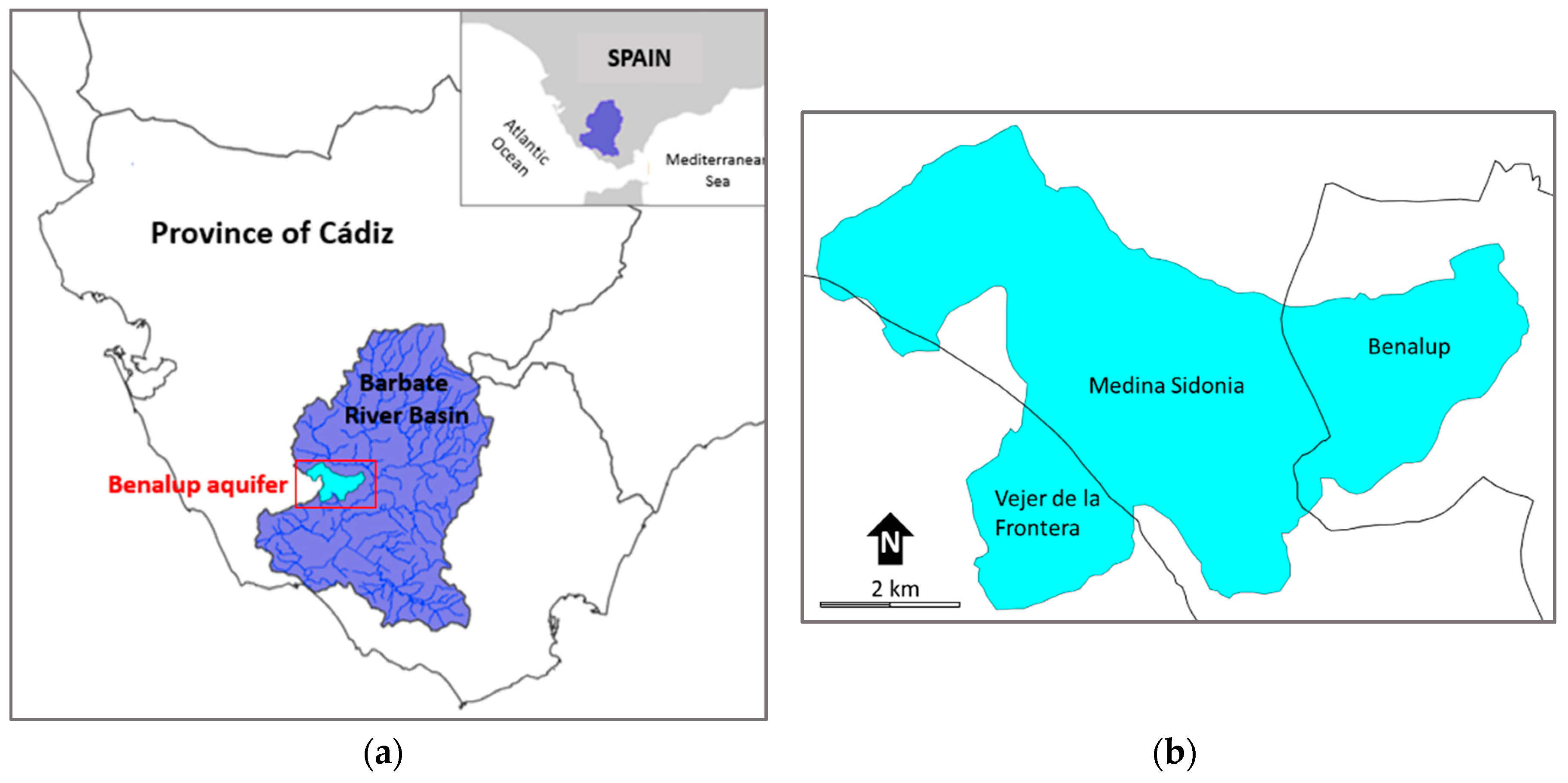
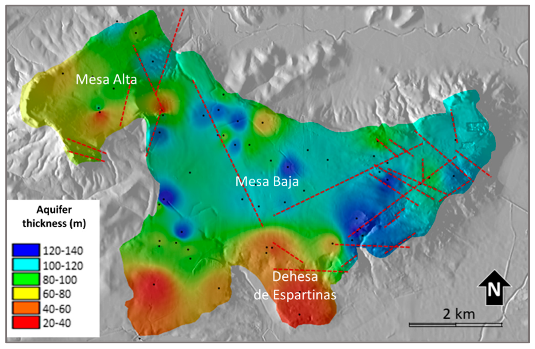
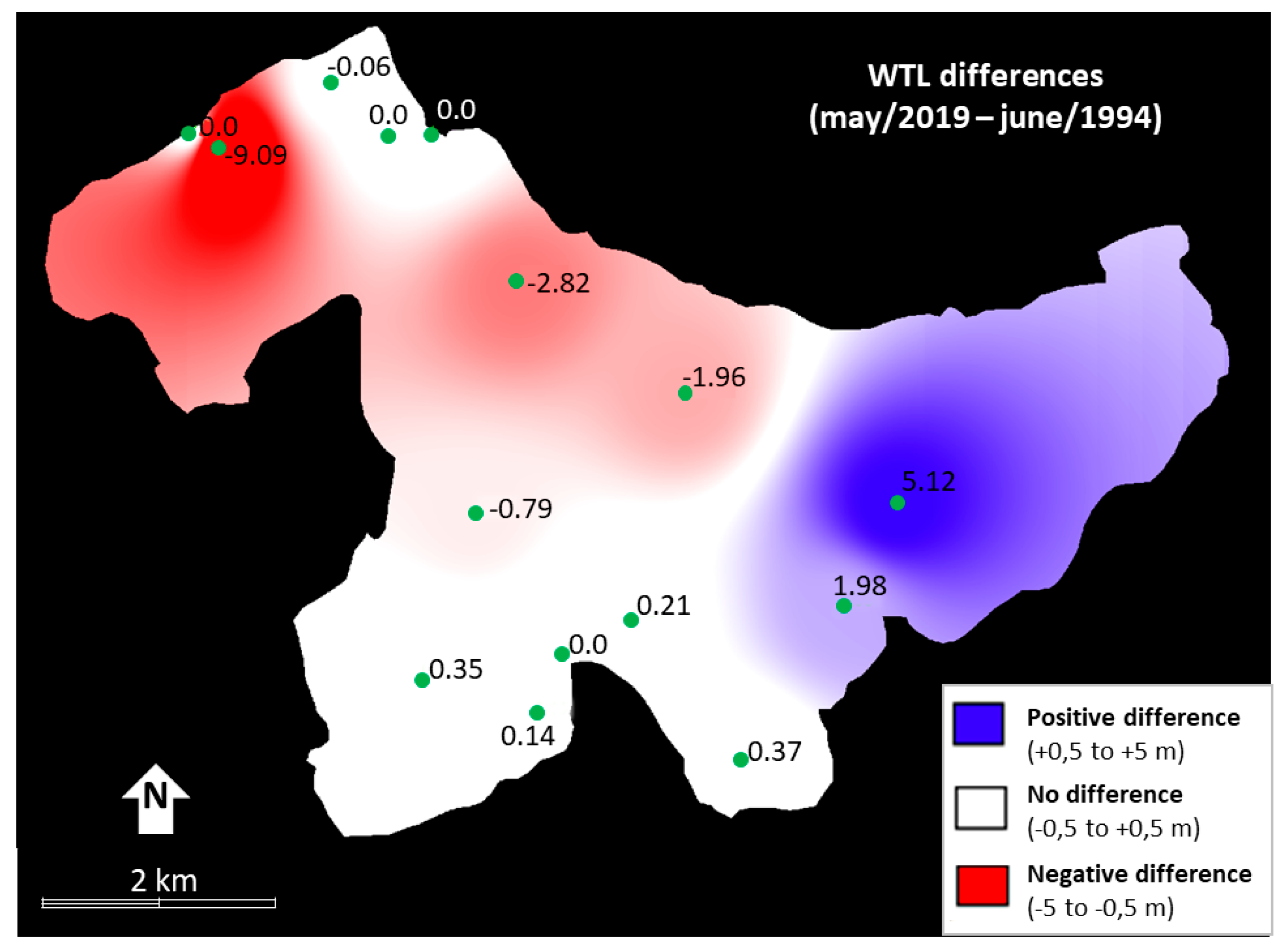
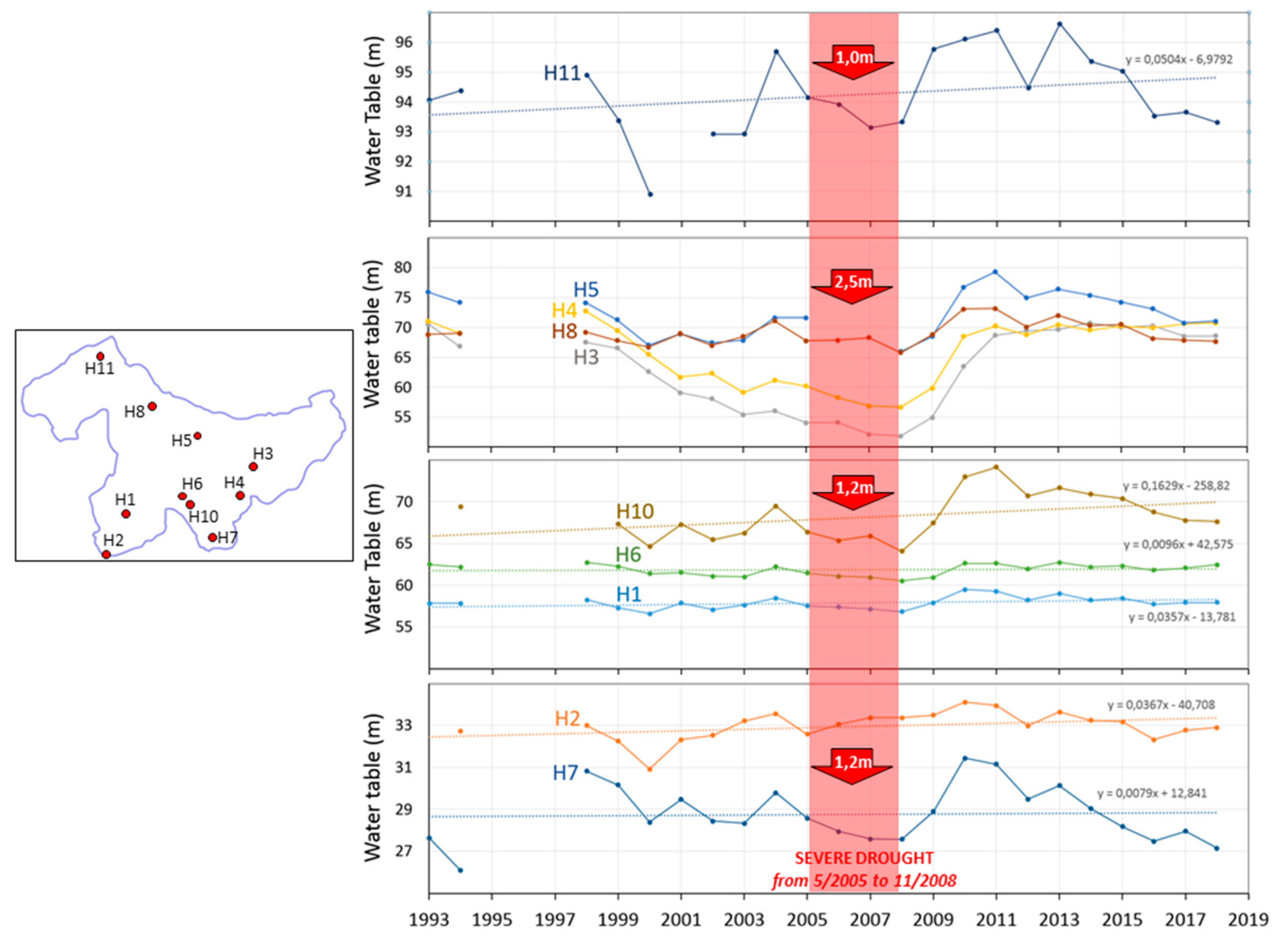
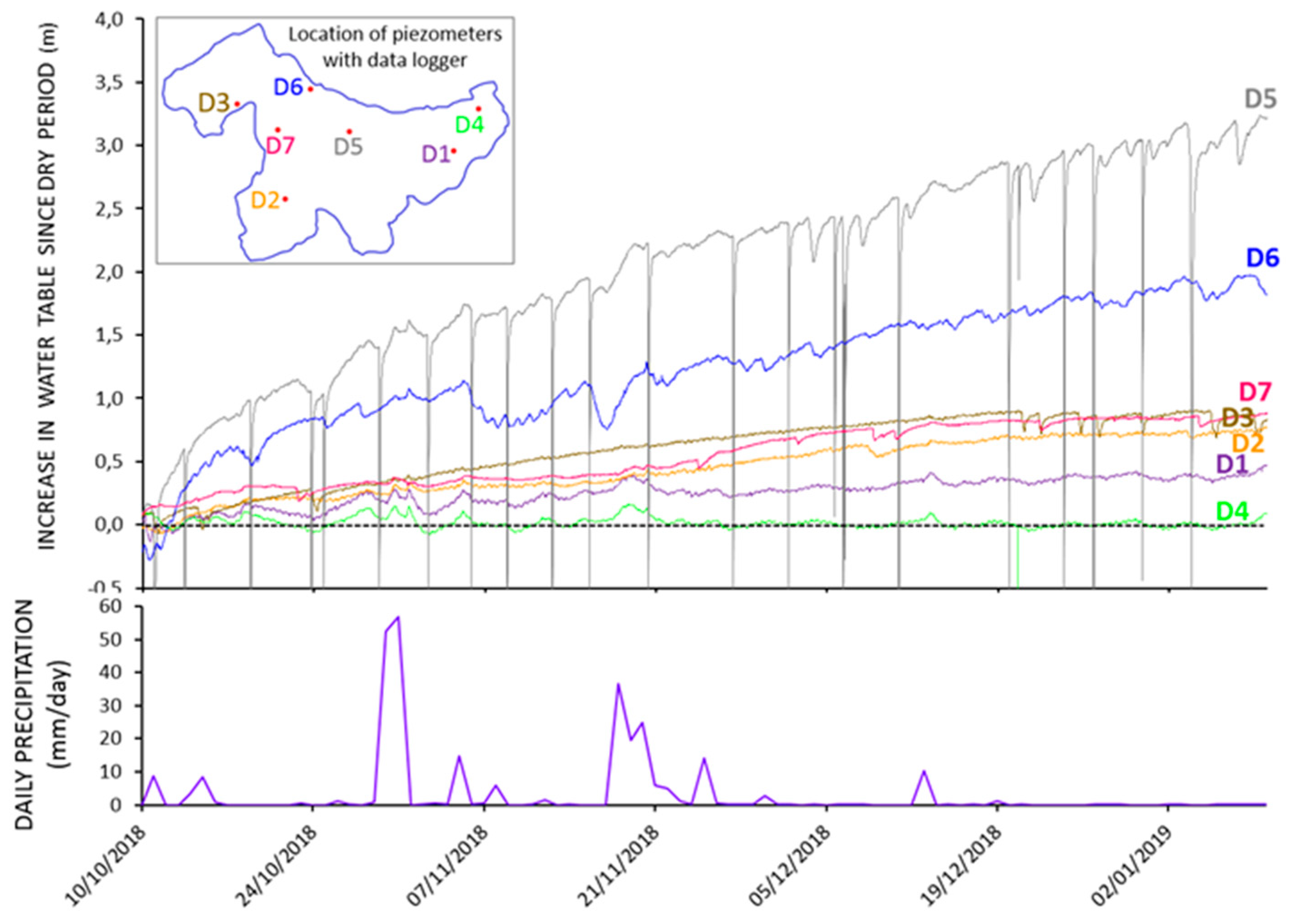
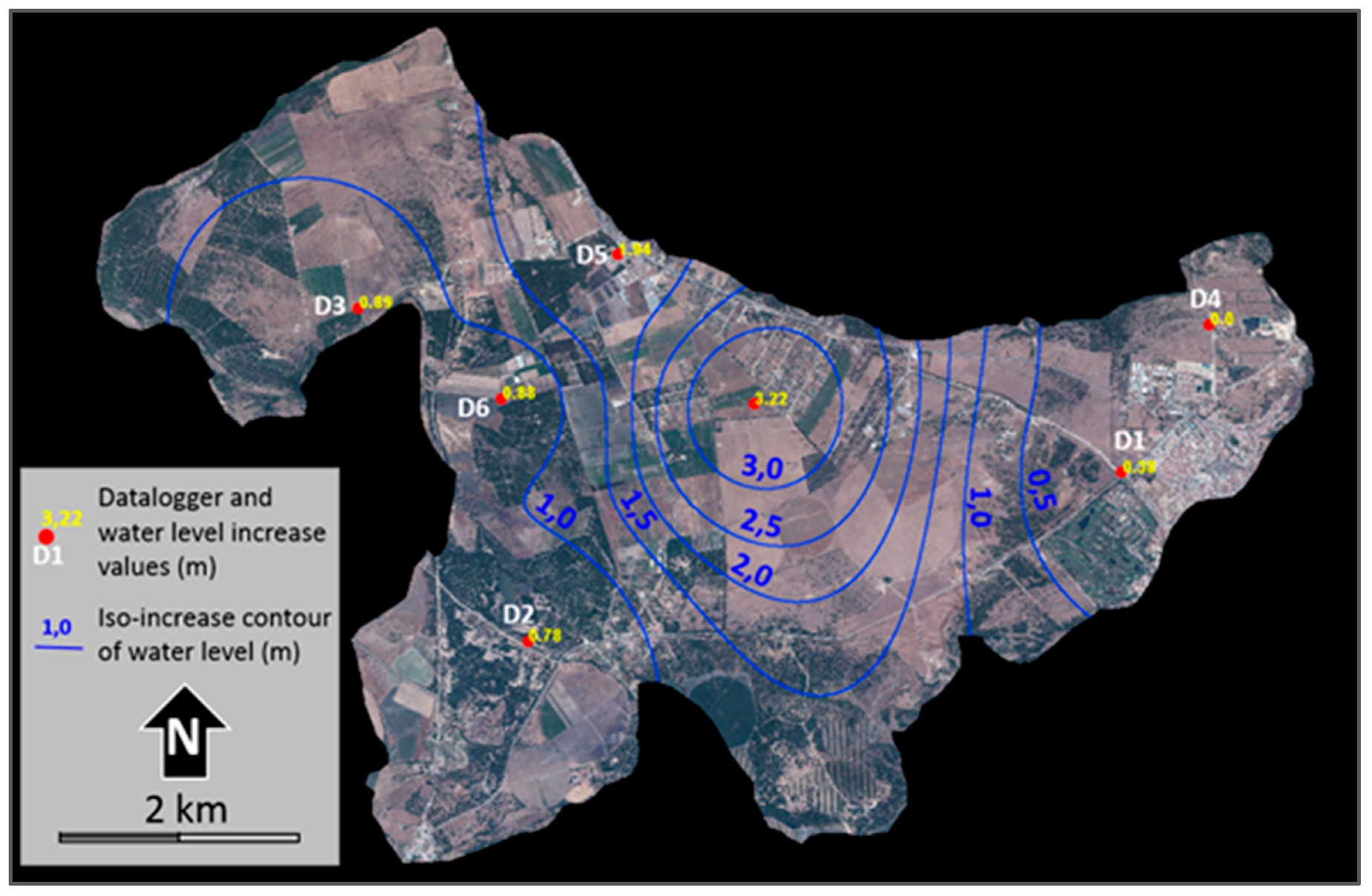
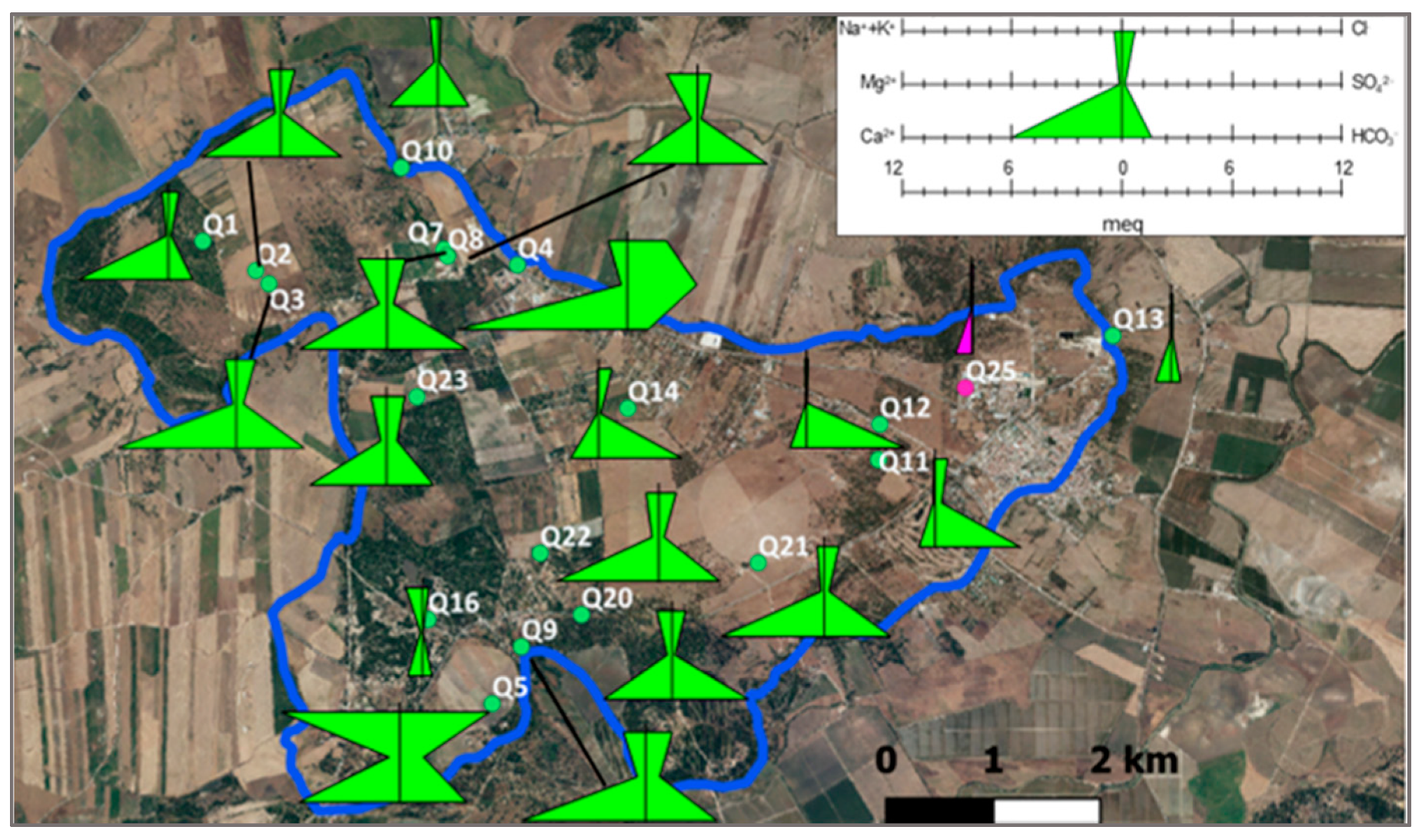
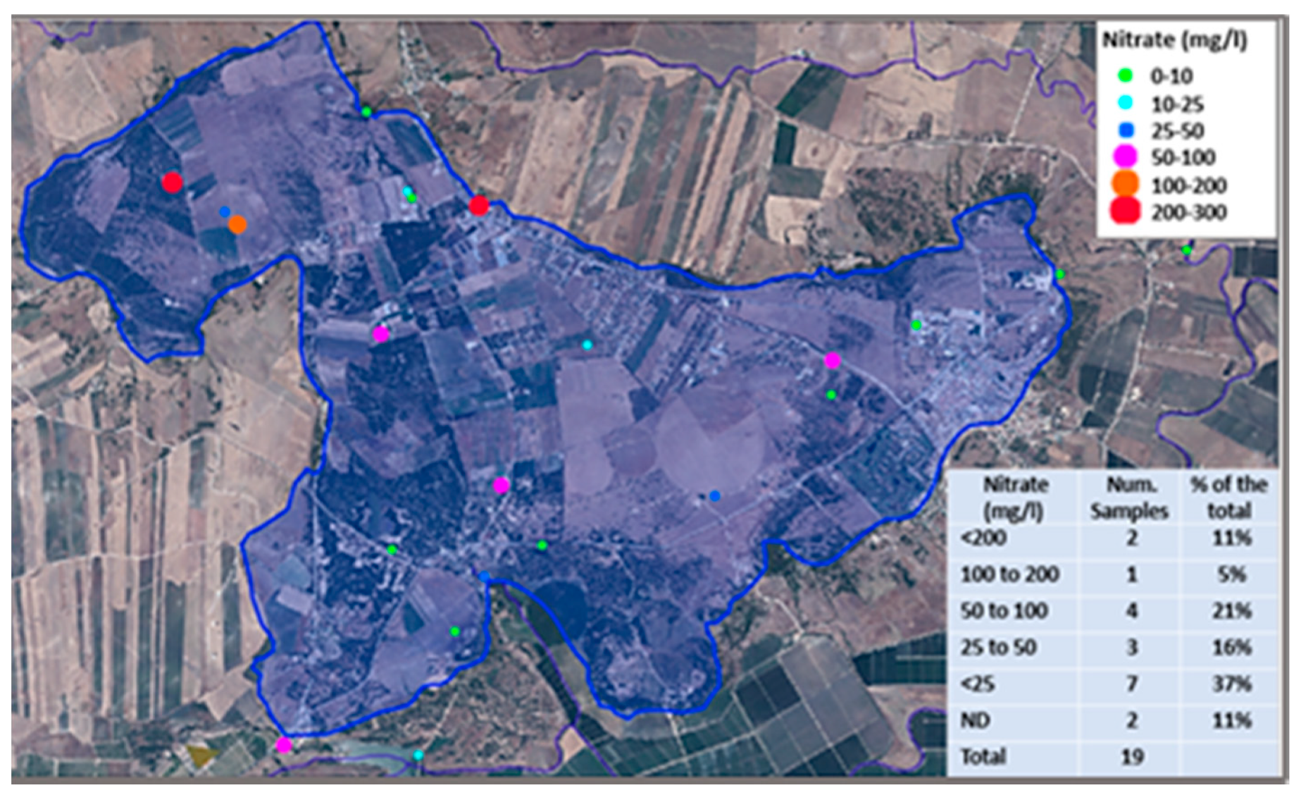
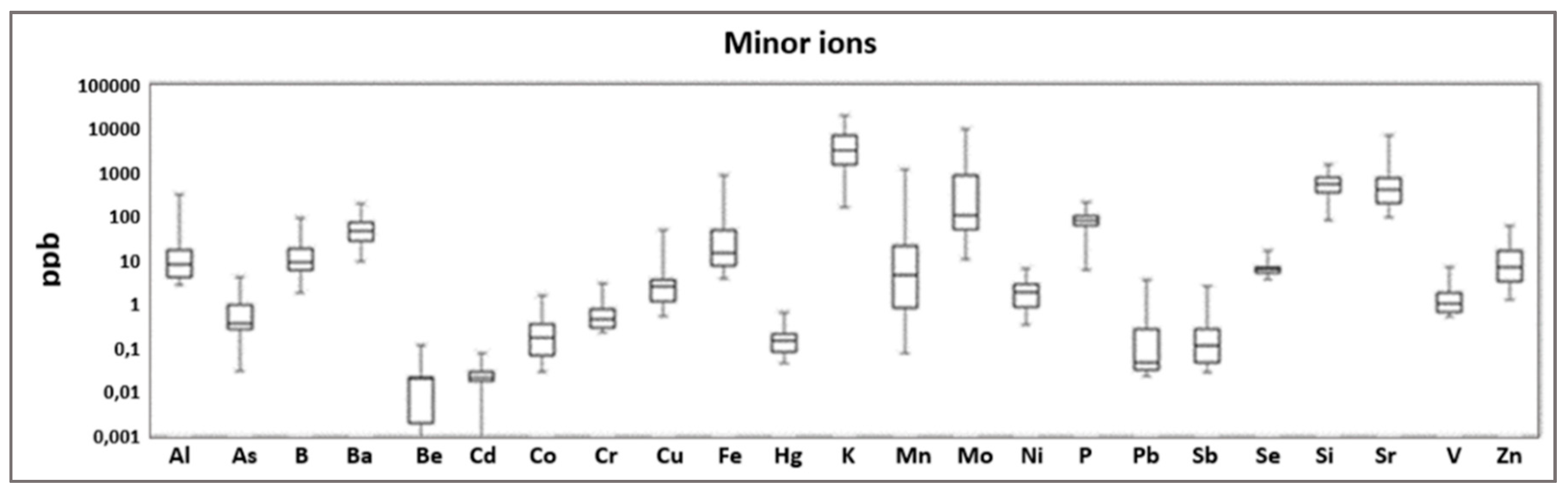
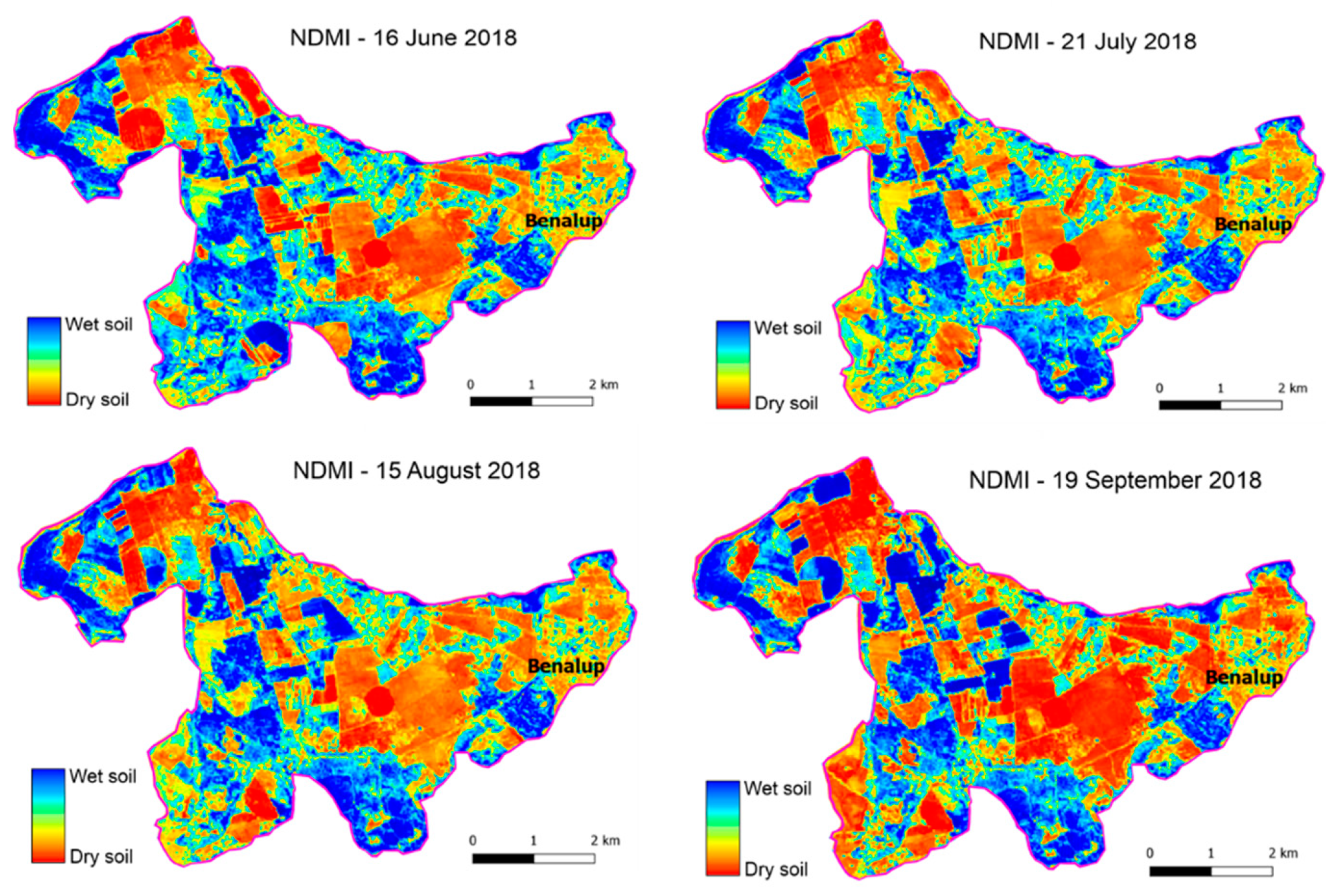


