In-Between ‘Smart’ Urban Growth and ‘Sluggish’ Rural Development? Reframing Population Dynamics in Greece, 1940–2019

 ,
,  and
and
Abstract
:1. Introduction
2. Methodology
2.1. Study Area
2.2. Data and Indicators
2.3. Contextual Variables
2.4. Data Analysis
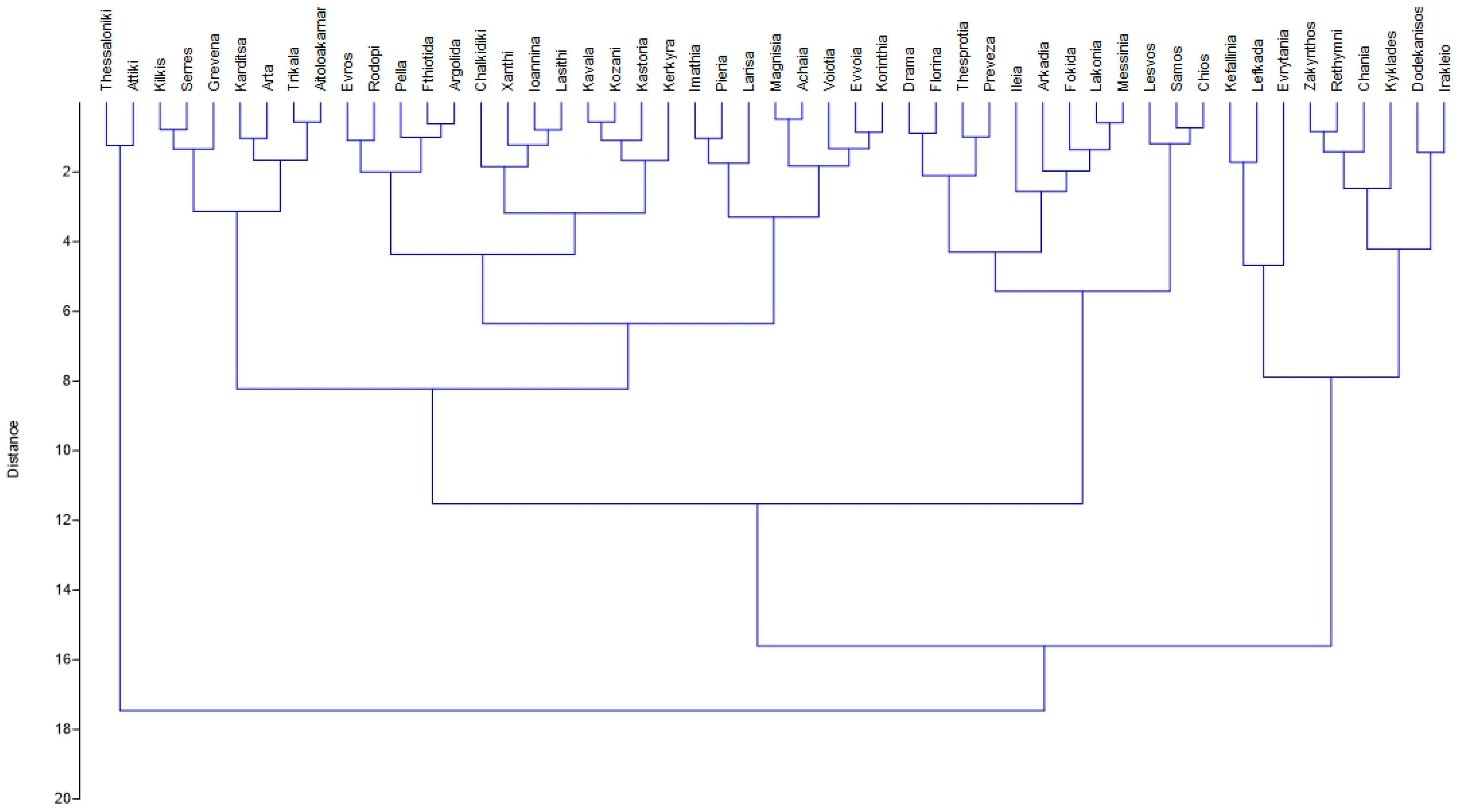
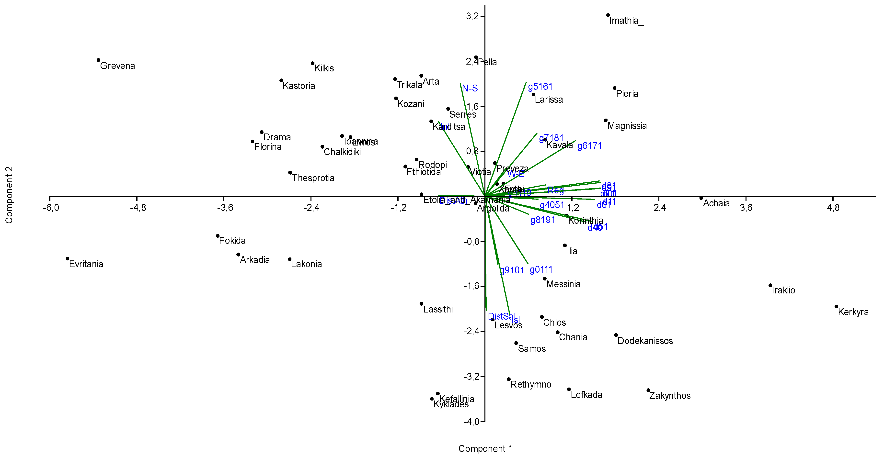
3. Results
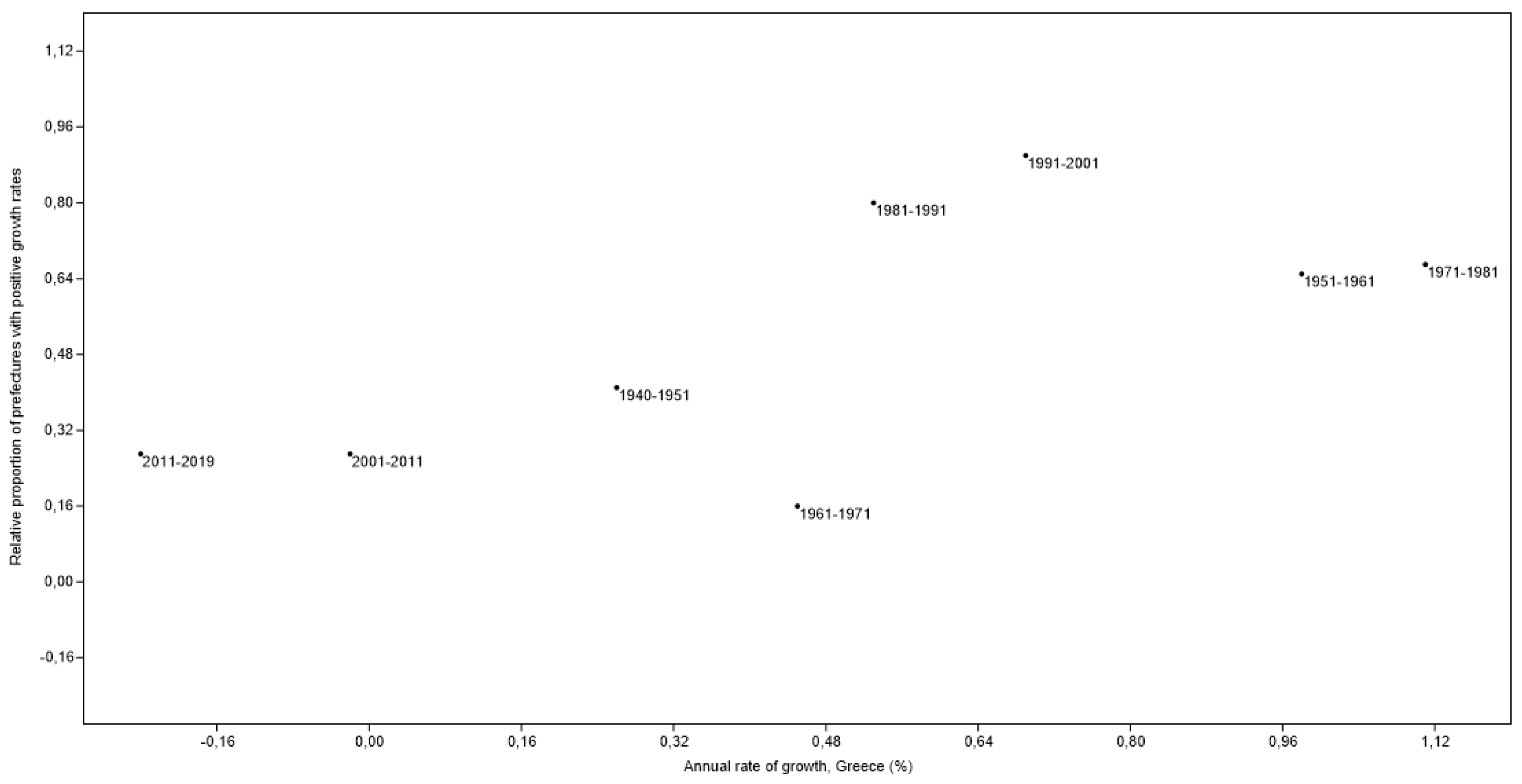
3.1. A Descriptive Analysis of Population Growth and Decline in Greece, 1940–2019
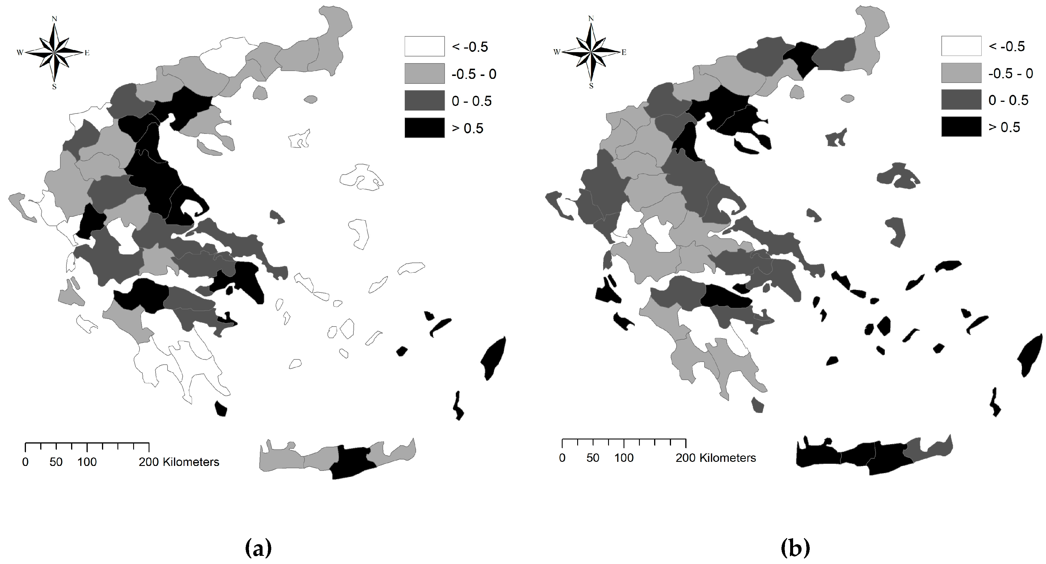
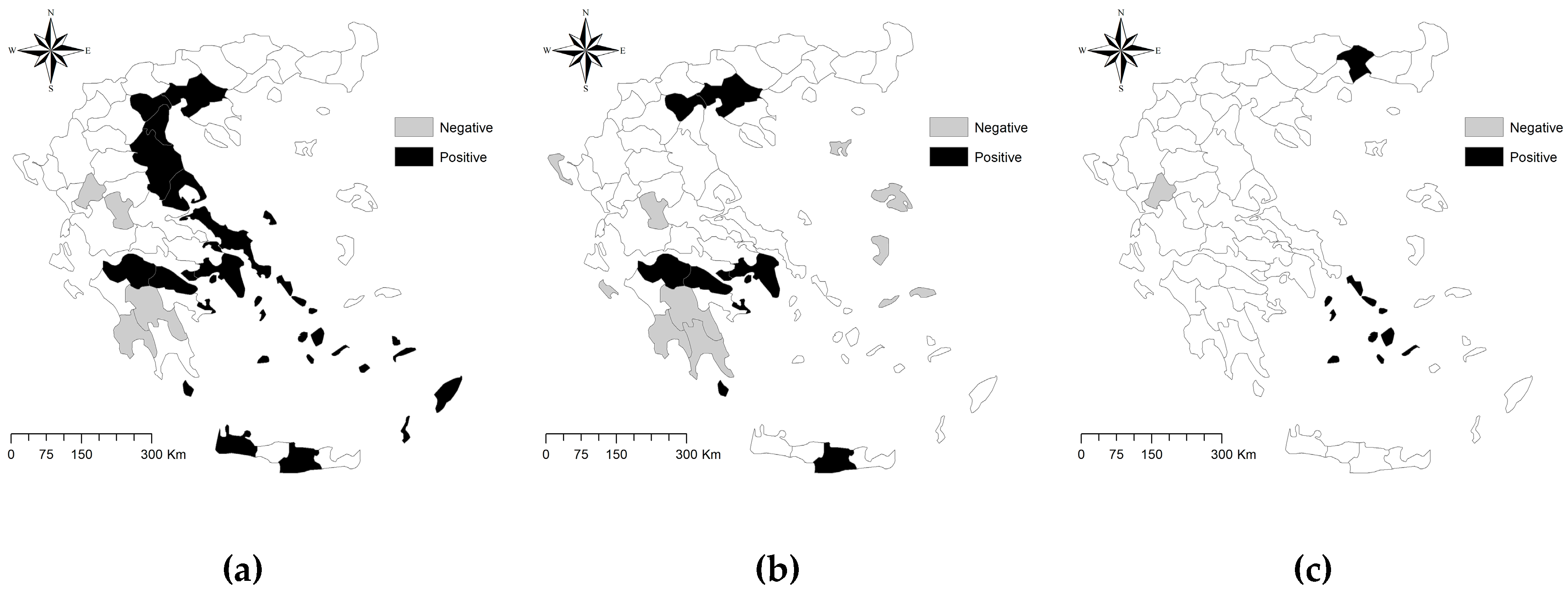
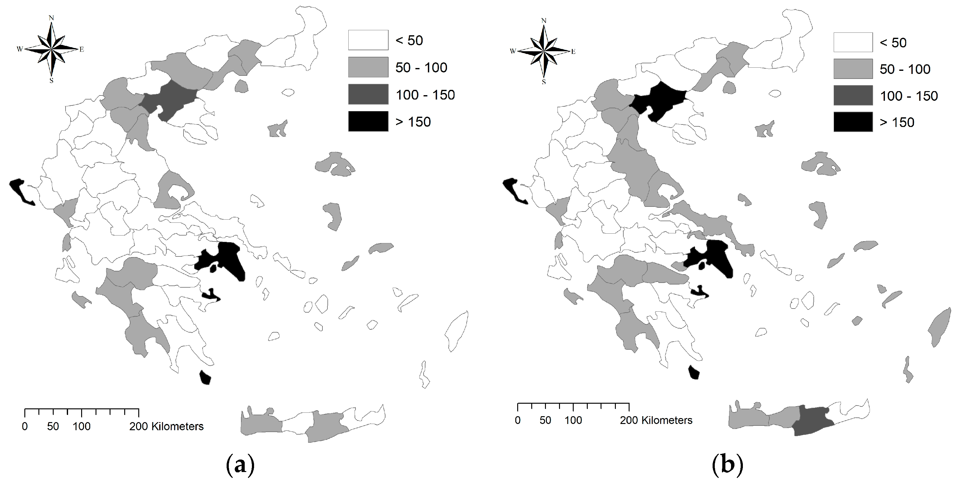
3.2. Spatial Regime of Long-Term Population Growth (or Decline) in Greece
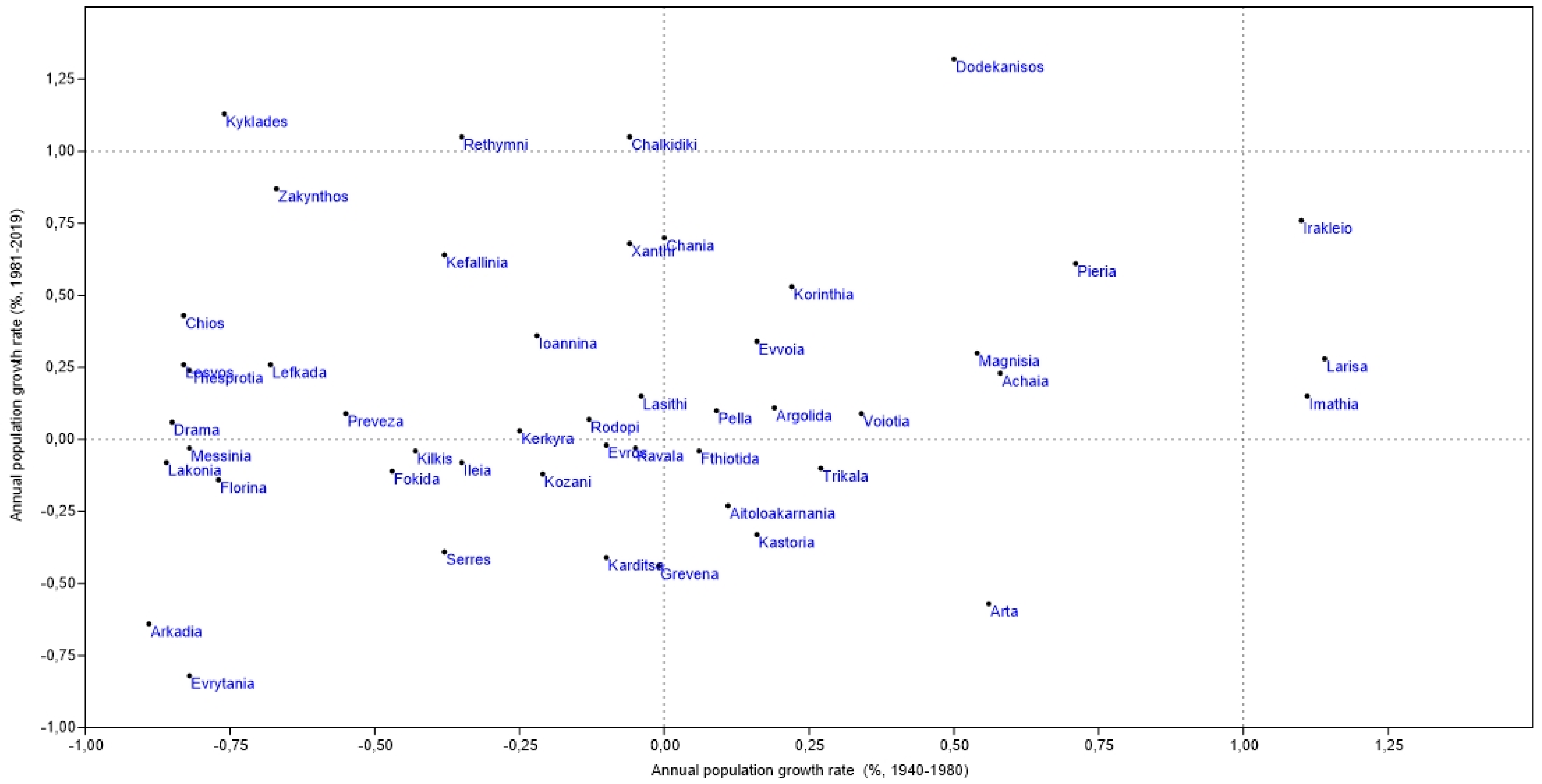
3.3. Population Growth and Territorial Background
4. Discussion
5. Conclusions
Author Contributions
Funding
Conflicts of Interest
References
- Tapinos, G.; Mason, A.; Bravo, J. Demographic Responses to Economic Adjustment in Latin America; Oxford University Press: New York, NY, USA, 1997; ISBN 978-0-19-829210-4. [Google Scholar]
- Chen, Y. Urban chaos and perplexing dynamics of urbanization. Lett. Spat. Resour. Sci. 2009, 2, 85. [Google Scholar] [CrossRef]
- Cechella, C.; Dentinho, T.; Silva, J.R. World centralities for political, demographic and market purposes. Lett. Spat. Resour. Sci. 2012, 5, 73–83. [Google Scholar] [CrossRef]
- Arapoglou, V.P.; Sayas, J. New Facets of Urban Segregation in Southern Europe: Gender, Migration and Social Class Change in Athens. Eur. Urban Reg. Stud. 2009. [Google Scholar] [CrossRef]
- Dyson, T. On Demographic and Democratic Transitions. Popul. Dev. Rev. 2013, 38, 83–102. [Google Scholar] [CrossRef]
- Bono, E.D.; Weber, A.; Winter-Ebmer, R. Fertility and economic instability: The role of unemployment and job displacement. J. Popul. Econ. 2015, 28, 463–478. [Google Scholar] [CrossRef] [Green Version]
- Walford, N.; Kurek, S. Outworking of the Second Demographic Transition: National Trends and Regional Patterns of Fertility Change in Poland, and England and Wales, 2002–2012. Popul. Space Place 2016, 22, 508–525. [Google Scholar] [CrossRef] [Green Version]
- Li, Z.; Cheng, J.; Wu, Q. Analyzing regional economic development patterns in a fast developing province of China through geographically weighted principal component analysis. Lett. Spat. Resour. Sci. 2016, 9, 233–245. [Google Scholar] [CrossRef]
- Benyaklef, M. Socio-economic disparities in the Mediterranean. Mediterr. Politics 1997, 2, 93–112. [Google Scholar] [CrossRef]
- Kulu, H.; Boyle, P.; Andersson, G. High Suburban Fertility: Evidence from Four Northern European Countries. Demogr. Res. 2009, 21, 915–944. [Google Scholar] [CrossRef]
- Kabisch, N.; Haase, D. Diversifying European agglomerations: Evidence of urban population trends for the 21st century. Popul. Space Place 2011, 17, 236–253. [Google Scholar] [CrossRef]
- Salvati, L.; Sateriano, A.; Grigoriadis, E. Crisis and the city: Profiling urban growth under economic expansion and stagnation. Lett. Spat. Resour. Sci. 2016, 9, 329–342. [Google Scholar] [CrossRef]
- Gkartzios, M.; Scott, K. A Cultural Panic in the Province? Counterurban Mobilities, Creativity, and Crisis in Greece. Popul. Space Place 2015, 21, 843–855. [Google Scholar] [CrossRef] [Green Version]
- Berry, B.J.L. Urbanization and Counterurbanization in the United States. ANNALS Am. Acad. Political Soc. Sci. 1980, 451, 13–20. [Google Scholar] [CrossRef]
- Roberts, S. A Critical Evaluation of the City Life Cycle Idea. Urban Geogr. 1991, 12, 431–449. [Google Scholar] [CrossRef]
- Pumain, D. Settlement systems in the evolution. Geogr. Ann. Ser. B Hum. Geogr. 2000, 82, 73–87. [Google Scholar] [CrossRef] [Green Version]
- Berg, M. van den City Children and Genderfied Neighbourhoods: The New Generation as Urban Regeneration Strategy. Int. J. Urban Reg. Res. 2013, 37, 523–536. [Google Scholar] [CrossRef]
- Bonavero, P.; Sforzi, F.; Dematteis, G. The Italian Urban System: Towards European Integration; Routledge: London, UK, 2009. [Google Scholar]
- Işik, O.; Pinarcioğlu, M.M. Geographies of a silent transition: A geographically weighted regression approach to regional fertility differences in Turkey. Eur. J. Popul. 2006, 22, 399–421. [Google Scholar] [CrossRef]
- Falagas, M.E.; Vouloumanou, E.K.; Mavros, M.N.; Karageorgopoulos, D.E. Economic crises and mortality: A review of the literature. Int. J. Clin. Pract. 2009, 63, 1128–1135. [Google Scholar] [CrossRef]
- Salvati, L. The Dark Side of the Crisis: Disparities in per Capita income (2000–12) and the Urban-Rural Gradient in Greece. Tijdschr. Voor Econ. en Soc. Geogr. 2016, 107, 628–641. [Google Scholar] [CrossRef]
- Haase, A.; Kabisch, S.; Steinführer, A.; Bouzarovski, S.; Hall, R.; Ogden, P. Emergent spaces of reurbanisation: Exploring the demographic dimension of inner-city residential change in a European setting. Popul. Space Place 2010, 16, 443–463. [Google Scholar] [CrossRef]
- Kroll, F.; Kabisch, N. The Relation of Diverging Urban Growth Processes and Demographic Change along an Urban–Rural Gradient. Popul. Space Place 2012, 18, 260–276. [Google Scholar] [CrossRef]
- Bosker, M. Growth, Agglomeration and Convergence: A Space-time Analysis for European Regions. Spat. Econ. Anal. 2007, 2, 91–100. [Google Scholar] [CrossRef]
- Carson, D.B.; Carson, D.A.; Porter, R.; Ahlin, C.Y.; Sköld, P. Decline, Adaptation or Transformation: New Perspectives on Demographic Change in Resource Peripheries in Australia and Sweden. Comp. Popul. Stud. 2016, 41. [Google Scholar]
- Serra, P.; Vera, A.; Tulla, A.F.; Salvati, L. Beyond urban–rural dichotomy: Exploring socioeconomic and land-use processes of change in Spain (1991–2011). Appl. Geogr. 2014, 55, 71–81. [Google Scholar] [CrossRef]
- Carlucci, M.; Grigoriadis, E.; Rontos, K.; Salvati, L. Revisiting a Hegemonic Concept: Long-term ‘Mediterranean Urbanization’ in Between City Re-polarization and Metropolitan Decline. Appl. Spat. Anal. 2017, 10, 347–362. [Google Scholar] [CrossRef]
- Cuadrado-Ciuraneta, S.; Durà-Guimerà, A.; Salvati, L. Not only tourism: Unravelling suburbanization, second-home expansion and “rural” sprawl in Catalonia, Spain. Urban Geogr. 2017, 38, 66–89. [Google Scholar] [CrossRef]
- Stockdale, A. Contemporary and ‘Messy’ Rural In-migration Processes: Comparing Counterurban and Lateral Rural Migration. Popul. Space Place 2016, 22, 599–616. [Google Scholar] [CrossRef] [Green Version]
- Biasi, R.; Colantoni, A.; Ferrara, C.; Ranalli, F.; Salvati, L. In-between sprawl and fires: Long-term forest expansion and settlement dynamics at the wildland–urban interface in Rome, Italy. Int. J. Sustain. Dev. World Ecol. 2015, 22, 467–475. [Google Scholar] [CrossRef]
- Mavrakis, A.; Papavasileiou, C.; Salvati, L. Towards (Un) sustainable urban growth? Industrial development, land-use, soil depletion and climate aridity in a Greek agro-forest area. J. Arid. Environ. 2015, 121, 1–6. [Google Scholar] [CrossRef]
- Zambon, I.; Serra, P.; Sauri, D.; Carlucci, M.; Salvati, L. Beyond the ‘Mediterranean city’: Socioeconomic disparities and urban sprawl in three Southern European cities. Geogr. Ann. Ser. B Hum. Geogr. 2017, 99, 319–337. [Google Scholar] [CrossRef]
- Davies, S. Regional resilience in the 2008–2010 downturn: Comparative evidence from European countries. Camb. J. Reg. Econ. Soc. 2011, 4, 369–382. [Google Scholar] [CrossRef]
- Connaughton, J.E. Local Economic Impact of the Great Recession of 2008/2009. RRS 2010, 40, 1–4. [Google Scholar]
- Di Feliciantonio, C.; Salvati, L.; Sarantakou, E.; Rontos, K. Class diversification, economic growth and urban sprawl: Evidences from a pre-crisis European city. Qual. Quant. 2018, 52, 1501–1522. [Google Scholar] [CrossRef]
- Ferrara, C.; Carlucci, M.; Grigoriadis, E.; Corona, P.; Salvati, L. A comprehensive insight into the geography of forest cover in Italy: Exploring the importance of socioeconomic local contexts. For. Policy Econ. 2017, 75, 12–22. [Google Scholar] [CrossRef] [Green Version]
- Petrakos, G.C. Urban Concentration and Agglomeration Economies: Re-examining the Relationship. Urban Stud. 1992. [Google Scholar] [CrossRef]
- Dijkstra, L.; Garcilazo, E.; McCann, P. The effects of the global financial crisis on European regions and cities. J. Econ. Geogr. 2015, 15, 935–949. [Google Scholar] [CrossRef]
- Chorianopoulos, I.; Tsilimigkas, G.; Koukoulas, S.; Balatsos, T. The shift to competitiveness and a new phase of sprawl in the Mediterranean city: Enterprises guiding growth in Messoghia—Athens. Cities 2014, 39, 133–143. [Google Scholar] [CrossRef]
- Bonifazi, C.; Heins, F. Testing the differential urbanisation model for Italy. Tijdschr. Voor Econ. en Soc. Geogr. 2003, 94, 23–37. [Google Scholar] [CrossRef]
- Frick, S.A.; Rodríguez-Pose, A. Change in urban concentration and economic growth. World Dev. 2018, 105, 156–170. [Google Scholar] [CrossRef]
- Rodríguez-Pose, A.; Fratesi, U. Between Development and Social Policies: The Impact of European Structural Funds in Objective 1 Regions. Reg. Stud. 2004, 38, 97–113. [Google Scholar] [CrossRef]
- Salvati, L.; Carlucci, M. In-Between Stability and Subtle Changes: Urban Growth, Population Structure, and the City Life Cycle in Rome. Popul. Space Place 2016, 22, 216–227. [Google Scholar] [CrossRef]
- Schneider, D. The Great Recession, Fertility, and Uncertainty: Evidence from the United States. J. Marriage Fam. 2015, 77, 1144–1156. [Google Scholar] [CrossRef]
- Modena, F.; Rondinelli, C.; Sabatini, F. Economic Insecurity and Fertility Intentions: The Case of Italy. Rev. Income Wealth 2014, 60, S233–S255. [Google Scholar] [CrossRef] [Green Version]
- Souliotis, N. Cultural economy, sovereign debt crisis and the importance of local contexts: The case of Athens. Cities 2013, 33, 61–68. [Google Scholar] [CrossRef]
- Wheaton, W.C.; Shishido, H. Urban Concentration, Agglomeration Economies, and the Level of Economic Development. Econ. Dev. Cult. Chang. 1981, 30, 17–30. [Google Scholar] [CrossRef]
- Caltabiano, M. A turning point in Italian fertility. J. Pop. Res. 2016, 33, 379–397. [Google Scholar] [CrossRef]
- Caltabiano, M.; Castiglioni, M.; Rosina, A. Lowest-Low Fertility: Signs of a recovery in Italy? Demogr. Res. 2009, 21, 681–718. [Google Scholar] [CrossRef] [Green Version]
- Cazzola, A.; Pasquini, L.; Angeli, A. The relationship between unemployment and fertility in Italy: A time-series analysis. Demogr. Res. 2016, 34, 1–38. [Google Scholar] [CrossRef] [Green Version]
- Rosti, L.; Yamaguchi, C.; Castagnetti, C. Educational Performance as Signalling Device: Evidence from Italy. Econ. Bull. 2005, 9, 1–7. [Google Scholar]
- Storper, M. Why do regions develop and change? The challenge for geography and economics. J. Econ. Geogr. 2011, 11, 333–346. [Google Scholar] [CrossRef] [Green Version]
- Rosen, A.M. Civilizing Climate: Social Responses to Climate Change in the Ancient Near East; Rowman Altamira: Lanham, MD, USA, 2007; ISBN 0-7591-0494-8. [Google Scholar]
- Lamonica, G.R.; Chelli, F.M. The performance of non-survey techniques for constructing sub-territorial input-output tables. Pap. Reg. Sci. 2018, 97, 1169–1202. [Google Scholar] [CrossRef]
- Sobotka, T.; Skirbekk, V.; Philipov, D. Economic Recession and Fertility in the Developed World. Popul. Dev. Rev. 2011, 37, 267–306. [Google Scholar] [CrossRef] [PubMed]
- De Rosa, S.; Salvati, L. Beyond a ‘side street story’? Naples from spontaneous centrality to entropic polycentricism, towards a ‘crisis city’. Cities 2016, 51, 74–83. [Google Scholar] [CrossRef]
- Vignoli, D.; Drefahl, S.; De Santis, G. Whose job instability affects the likelihood of becoming a parent in Italy? A tale of two partners. Demogr. Res. 2012, 26, 41–62. [Google Scholar] [CrossRef] [Green Version]
- Salvati, L.; Zitti, M.; Ceccarelli, T. Integrating economic and environmental indicators in the assessment of desertification risk: A case study. Appl. Ecol. Env. Res. 2007, 6, 129–138. [Google Scholar] [CrossRef]
- Lerch, M. Internal and International Migration Across the Urban Hierarchy in Albania. Popul. Res. Policy Rev. 2016, 35, 851–876. [Google Scholar] [CrossRef] [Green Version]
- Maloutas, T. Segregation, Social Polarization and Immigration in Athens during the 1990s: Theoretical Expectations and Contextual Difference. Int. J. Urban Reg. Res. 2007, 31, 733–758. [Google Scholar] [CrossRef]
- Di Feliciantonio, C.; Salvati, L. ‘Southern’ Alternatives of Urban Diffusion: Investigating Settlement Characteristics and Socio-Economic Patterns in Three Mediterranean Regions. Tijdschr. Voor Econ. en Soc. Geogr. 2015, 106, 453–470. [Google Scholar] [CrossRef]
- Tragaki, A.; Bagavos, C. Male fertility in Greece: Trends and differentials by education level and employment status. Demogr. Res. 2014, 31, 137–160. [Google Scholar] [CrossRef] [Green Version]
- Copus, A.; Mantino, F.; Noguera, J. Inner Peripheries: An oxymoron or a real challenge for territorial cohesion? Ital. J. Plan. Pract. 2017, 7, 24–49. [Google Scholar]
- Combes, P.-P.; Duranton, G.; Gobillon, L. The identification of agglomeration economies. J. Econ. Geogr. 2011, 11, 253–266. [Google Scholar] [CrossRef] [Green Version]
- Lopez-Gay, A. Population growth and re-urbanization in Spanish inner cities: The role of internal migration and residential mobility. Quetelet J. 2014, 2, 67–92. [Google Scholar] [CrossRef] [Green Version]
- Pili, S.; Grigoriadis, E.; Carlucci, M.; Clemente, M.; Salvati, L. Towards sustainable growth? A multi-criteria assessment of (changing) urban forms. Ecol. Indic. 2017, 76, 71–80. [Google Scholar] [CrossRef]
- Rontos, K. Demographic Trends, Young People’s Attitudes towards Marriage and Socio-economic Changes Related to Family Formation in Greece and in the European Union: A Comparative Analysis Based on Official and Survey Research Data. Int. J. Econ. Bus. Adm. (IJEBA) 2015, III, 11–33. [Google Scholar] [CrossRef]
- Couch, C.; Petschel-Held, G.; Leontidou, L. Urban Sprawl in Europe: Landscape, Land-Use Change and Policy Wiley; Wiley-Blackwel: London, UK, 2008. [Google Scholar]
- Colantoni, A.; Grigoriadis, E.; Sateriano, A.; Venanzoni, G.; Salvati, L. Cities as selective land predators? A lesson on urban growth, deregulated planning and sprawl containment. Sci. Total. Environ. 2016, 545–546, 329–339. [Google Scholar] [CrossRef] [PubMed]
- Salvati, L.; Zitti, M. Regional convergence of environmental variables: Empirical evidences from land degradation. Ecol. Econ. 2008, 68, 162–168. [Google Scholar] [CrossRef]
- Zambon, I.; Benedetti, A.; Ferrara, C.; Salvati, L. Soil Matters? A Multivariate Analysis of Socioeconomic Constraints to Urban Expansion in Mediterranean Europe. Ecol. Econ. 2018, 146, 173–183. [Google Scholar] [CrossRef]
- Billari, F.C.; Kohler, H.-P. Patterns of Low and Lowest-Low Fertility in Europe. Popul. Stud. 2004, 58, 161–176. [Google Scholar] [CrossRef]
- Surkyn, J.; Lesthaeghe, R. Value Orientations and the Second Demographic Transition (SDT) in Northern, Western and Southern Europe: An Update. Demogr. Res. 2004, 3, 45–86. [Google Scholar] [CrossRef]
- Lesthaeghe, R.J.; Neidert, L. The Second Demographic Transition in the United States: Exception or Textbook Example? Popul. Dev. Rev. 2006, 32, 669–698. [Google Scholar] [CrossRef]
- Peck, J. Austerity urbanism. City 2012, 16, 626–655. [Google Scholar] [CrossRef]
- Billari, F.C.; Kohler, H.-P.; Andersson, G.; Lundström, H. Approaching the Limit: Long-Term Trends in Late and Very Late Fertility. Popul. Dev. Rev. 2007, 33, 149–170. [Google Scholar] [CrossRef]
- Pison, G. Two children per woman in France in 2010: Is French fertility immune to economic crisis? Popul. Soc. 2011, 476, 4. [Google Scholar]
- Reher, D.S. Economic and Social Implications of the Demographic Transition. Popul. Dev. Rev. 2011, 37, 11–33. [Google Scholar] [CrossRef]
- Champion, T.; Hugo, G. New Forms of Urbanization: Beyond the Urban-Rural Dichotomy; Routledge: London, UK, 2017; ISBN 978-1-315-24807-3. [Google Scholar]
- Cherlin, A.; Cumberworth, E.; Morgan, S.P.; Wimer, C. The Effects of the Great Recession on Family Structure and Fertility. ANNALS Am. Acad. Political Soc. Sci. 2013, 650, 214–231. [Google Scholar] [CrossRef]
- Goldstein, J.; Kreyenfeld, M.; Jasilioniene, A.; Karaman Örsal, D.D. Fertility Reactions to the “Great Recession” in Europe: Recent Evidence from Order-Specific Data. Demogr. Res. 2013, 29, 85–104. [Google Scholar] [CrossRef] [Green Version]
- Lee, K.O.; Painter, G. What happens to household formation in a recession? J. Urban Econ. 2013, 76, 93–109. [Google Scholar] [CrossRef]
- Palloni, A.; Tienda, M. Demographic Responses to Economic Recessions in Latin America Since 1900. Sociol. Inq. 1992, 62, 246–270. [Google Scholar] [CrossRef]
- García, M. The Breakdown of the Spanish Urban Growth Model: Social and Territorial Effects of the Global Crisis. Int. J. Urban Reg. Res. 2010, 34, 967–980. [Google Scholar] [CrossRef] [Green Version]
- Pérez, J.M.G. The Real Estate and Economic Crisis: An Opportunity for Urban Return and Rehabilitation Policies in Spain. Sustainability 2010, 2, 1571–1601. [Google Scholar] [CrossRef] [Green Version]
- Rontos, K.; Grigoriadis, E.; Sateriano, A.; Syrmali, M.; Vavouras, I.; Salvati, L. Lost in protest, found in segregation: Divided cities in the light of the 2015 “Oχι” referendum in Greece. City Cult. Soc. 2016, 7, 139–148. [Google Scholar] [CrossRef]
- Gavalas, V.S.; Rontos, K.; Salvati, L. Who Becomes an Unwed Mother in Greece? Sociodemographic and Geographical Aspects of an Emerging Phenomenon. Popul. Space Place 2014, 20, 250–263. [Google Scholar] [CrossRef]
- Remoundou, K.; Gkartzios, M.; Garrod, G. Conceptualizing Mobility in Times of Crisis: Towards Crisis-Led Counterurbanization? Reg. Stud. 2016, 50, 1663–1674. [Google Scholar] [CrossRef] [Green Version]
- Copus, A.; Melo, P.C.; Kaup, S.; Tagai, G.; Artelaris, P. Regional poverty mapping in Europe—Challenges, advances, benefits and limitations. Local Econ. 2015, 30, 742–764. [Google Scholar] [CrossRef]
- Gkartzios, M. ‘Leaving Athens’: Narratives of counterurbanisation in times of crisis. J. Rural. Stud. 2013, 32, 158–167. [Google Scholar] [CrossRef]
- Tapia, F.J.B.; Díez-Minguela, A.; Martinez-Galarraga, J. Tracing the Evolution of Agglomeration Economies: Spain, 1860–1991. J. Econ. Hist. 2018, 78, 81–117. [Google Scholar] [CrossRef] [Green Version]
- Gil-Alonso, F.; Bayona-i-Carrasco, J.; Pujadas-i-Rúbies, I. From boom to crash: Spanish urban areas in a decade of change (2001–2011). Eur. Urban Reg. Stud. 2016, 23, 198–216. [Google Scholar] [CrossRef]
- Goerlich, F.J.; Mas, M. La concentration spatiale de la population espagnole de 1900 à 2001: Confirmations empiriques. Population 2008, 63, 731–745. [Google Scholar] [CrossRef]
- Karamesouti, M.; Detsis, V.; Kounalaki, A.; Vasiliou, P.; Salvati, L.; Kosmas, C. Land-use and land degradation processes affecting soil resources: {Evidence} from a traditional {Mediterranean} cropland ({Greece}). CATENA 2015, 132, 45–55. [Google Scholar] [CrossRef]
- Stuckler, D.; Reeves, A.; Karanikolos, M.; McKee, M. The health effects of the global financial crisis: Can we reconcile the differing views? A network analysis of literature across disciplines. Health Econ. Policy Law 2015, 10, 83–99. [Google Scholar] [CrossRef]
- Fuchs, R.J.; Demko, G.J. Rethinking population distribution policies. Popul. Res. Policy Rev. 1983, 2, 161–187. [Google Scholar] [CrossRef]
- Chelli, F.; Rosti, L. Age and gender differences in Italian workers’ mobility. Int. J. Manpow. 2002, 23, 313–325. [Google Scholar] [CrossRef]
- Monastiriotis, V. Examining the consistency of spatial association patterns across socio-economic indicators: An application to the Greek regions. Empir. Econ. 2009, 37, 25–49. [Google Scholar] [CrossRef]
- Monastiriotis, V. Making geographical sense of the Greek austerity measures: Compositional effects and long-run implications. Camb. J. Reg. Econ. Soc. 2011, 4, 323–337. [Google Scholar] [CrossRef]
- Koutsampelas, C.; Tsakloglou, P. The distribution of full income in Greece. Int. J. Soc. Econ. 2013, 40, 311–330. [Google Scholar] [CrossRef] [Green Version]
- Kosmas, C.; Karamesouti, M.; Kounalaki, K.; Detsis, V.; Vassiliou, P.; Salvati, L. Land degradation and long-term changes in agro-pastoral systems: An empirical analysis of ecological resilience in Asteroussia—Crete (Greece). CATENA 2016, 147, 196–204. [Google Scholar] [CrossRef]
- Lusardi, A.; Schneider, D.; Tufano, P. The Economic Crisis and Medical Care Use: Comparative Evidence from Five High-Income Countries. Soc. Sci. Q. 2015, 96, 202–213. [Google Scholar] [CrossRef]
- Carlucci, M.; Chelli, F.M.; Salvati, L. Toward a New Cycle: Short-Term Population Dynamics, Gentrification, and Re-Urbanization of Milan (Italy). Sustainability 2018, 10, 3014. [Google Scholar] [CrossRef] [Green Version]
- Ciommi, M.; Chelli, F.M.; Carlucci, M.; Salvati, L. Urban Growth and Demographic Dynamics in Southern Europe: Toward a New Statistical Approach to Regional Science. Sustainability 2018, 10, 2765. [Google Scholar] [CrossRef] [Green Version]
- Ciommi, M.; Chelli, F.M.; Salvati, L. Integrating parametric and non-parametric multivariate analysis of urban growth and commuting patterns in a European metropolitan area. Qual. Quant. 2019, 53, 957–979. [Google Scholar] [CrossRef]
- Salvati, L.; Ciommi, M.T.; Serra, P.; Chelli, F.M. Exploring the spatial structure of housing prices under economic expansion and stagnation: The role of socio-demographic factors in metropolitan Rome, Italy. Land Use Policy 2019, 81, 143–152. [Google Scholar] [CrossRef]
- Kreyenfeld, M.; Andersson, G.; Pailhé, A. Economic Uncertainty and Family Dynamics in Europe: Introduction. Demogr. Res. 2012, S12, 835–852. [Google Scholar] [CrossRef] [Green Version]
- Hofmann, B.; Hohmeyer, K. Perceived Economic Uncertainty and Fertility: Evidence From a Labor Market Reform. J. Marriage Fam. 2013, 75, 503–521. [Google Scholar] [CrossRef]
- Simou, E.; Koutsogeorgou, E. Effects of the economic crisis on health and healthcare in Greece in the literature from 2009 to 2013: A systematic review. Health Policy 2014, 115, 111–119. [Google Scholar] [CrossRef] [Green Version]
- Lamonica, G.R.; Recchioni, M.C.; Chelli, F.M.; Salvati, L. The efficiency of the cross-entropy method when estimating the technical coefficients of input–output tables. Spat. Econ. Anal. 2020, 15, 62–91. [Google Scholar] [CrossRef]
- Klasen, S.; Nestmann, T. Population, population density and technological change. J. Popul. Econ. 2006, 19, 611–626. [Google Scholar] [CrossRef] [Green Version]
- Dyson, T. The Role of the Demographic Transition in the Process of Urbanization. Popul. Dev. Rev. 2011, 37, 34–54. [Google Scholar] [CrossRef]
- Lerch, M. The Role of Migration in the Urban Transition: A Demonstration from Albania. Demography 2014, 51, 1527–1550. [Google Scholar] [CrossRef] [Green Version]
- Caldwell, J.C. Demographic Transition Theory; Springer: Amsterdam, The Netherlands, 2006; ISBN 978-1-4020-4373-4. [Google Scholar]
- Zitti, M.; Ferrara, C.; Perini, L.; Carlucci, M.; Salvati, L. Long-Term Urban Growth and Land Use Efficiency in Southern Europe: Implications for Sustainable Land Management. Sustainability 2015, 7, 3359–3385. [Google Scholar] [CrossRef] [Green Version]
- Camagni, R.; Capello, R.; Caragliu, A. Static vs. dynamic agglomeration economies. Spatial context and structural evolution behind urban growth. Pap. Reg. Sci. 2016, 95, 133–158. [Google Scholar] [CrossRef]
- Berliant, M.; Wang, P. Dynamic Urban Models: Agglomeration and Growth. In Contributions to Economic Analysis; Elsevier: London, UK, 2004; Volume 266, pp. 531–581. ISBN 978-0-444-51481-3. [Google Scholar]


| Variable | Percent Rate of Population Growth | ||
|---|---|---|---|
| 1940–2019 | 1940–1980 | 1981–2019 | |
| Density | 0.05 | −0.07 | 0.36 * |
| North–South | 0.04 | 0.19 | −0.23 |
| West–East | 0.44 * | 0.31 * | 0.37 * |
| DistAthens | −0.04 | −0.05 | 0.00 |
| DistSalonika | −0.06 | −0.25 | 0.32 * |
| RegCapital | 0.42 * | 0.39 * | 0.31 * |
| Internal dis. | −0.22 | 0.01 | −0.49 * |
| Island | 0.04 | −0.25 | 0.55 * |
| Variable | Coeff. | Std. err. | t | p | Variable | Coeff. | Std. err. | t | p |
|---|---|---|---|---|---|---|---|---|---|
| 1940–1951: Adj-R2 = 0.19; F = 2.43; p = 0.03 | 1951–1961: Adj-R2 = 0.47; F = 6.53; p < 0.01 | ||||||||
| Constant | 0.00 | 0.13 | 0.01 | 0.99 | Constant | 0.00 | 0.10 | −0.01 | 0.99 |
| Density | −0.22 | 0.17 | −1.31 | 0.20 | Density | 0.26 * | 0.15 | 1.74 | 0.09 |
| North–South | 0.19 | 0.28 | 0.69 | 0.49 | North–South | 0.43 * | 0.22 | 1.91 | 0.06 |
| West–East | −0.17 | 0.15 | −1.13 | 0.26 | West–East | 0.22 * | 0.12 | 1.83 | 0.07 |
| DistAthens | −0.55 * | 0.22 | −2.48 | 0.02 | DistAthens | −0.15 | 0.18 | −0.81 | 0.42 |
| DistSalonika | −0.43 * | 0.21 | −2.07 | 0.04 | DistSalonika | 0.01 | 0.17 | 0.04 | 0.97 |
| RegCapital | 0.36 * | 0.13 | 2.70 | 0.01 | RegCapital | 0.20 * | 0.11 | 1.79 | 0.08 |
| Internal dist. | −0.03 | 0.16 | −0.19 | 0.85 | Internal dist. | 0.13 | 0.13 | 0.94 | 0.35 |
| Island | 0.71 * | 0.25 | 2.84 | 0.01 | Island | −0.30 | 0.21 | −1.42 | 0.16 |
| 1961–1971: Adj-R2 = 0.60; F = 10.48; p < 0.001 | 1971–1981: Adj-R2 = 0.33; F = 4.12; p < 0.001 | ||||||||
| Constant | 0.00 | 0.09 | 0.01 | 0.99 | Constant | 0.00 | 0.11 | 0.00 | 1.00 |
| Density | 0.37 * | 0.12 | 2.96 | 0.01 | Density | 0.15 | 0.17 | 0.88 | 0.38 |
| North–South | 0.10 | 0.20 | 0.50 | 0.62 | North–South | 0.10 | 0.25 | 0.40 | 0.69 |
| West–East | 0.21 * | 0.10 | 2.00 | 0.05 | West–East | 0.36 * | 0.13 | 2.71 | 0.01 |
| DistAthens | −0.34 * | 0.16 | −2.12 | 0.04 | DistAthens | −0.02 | 0.21 | −0.11 | 0.91 |
| DistSalonika | -0.18 | 0.15 | −1.25 | 0.22 | DistSalonika | −0.01 | 0.19 | −0.06 | 0.96 |
| RegCapital | 0.31 * | 0.10 | 3.16 | 0.00 | RegCapital | 0.40 * | 0.13 | 3.08 | 0.00 |
| Internal dist. | −0.07 | 0.11 | −0.66 | 0.51 | Internal dist. | −0.01 | 0.15 | −0.05 | 0.96 |
| Island | −0.07 | 0.18 | −0.38 | 0.70 | Island | −0.21 | 0.23 | −0.93 | 0.36 |
| 1981–1991: Adj-R2 = 0.08; F = 1.57; p = 0.16 | 1991–2001: Adj-R2 = 0.14; F = 1.98; p = 0.08 | ||||||||
| Constant | 0.00 | 0.13 | 0.00 | 1.00 | Constant | 0.00 | 0.13 | 0.01 | 0.99 |
| Density | −0.05 | 0.20 | −0.23 | 0.82 | Density | −0.27 | 0.20 | −1.36 | 0.18 |
| North–South | −0.05 | 0.30 | −0.17 | 0.87 | North–South | −0.15 | 0.29 | −0.52 | 0.61 |
| West–East | 0.12 | 0.15 | 0.79 | 0.43 | West–East | −0.01 | 0.15 | −0.07 | 0.95 |
| DistAthens | −0.19 | 0.25 | −0.76 | 0.45 | DistAthens | −0.06 | 0.24 | −0.23 | 0.82 |
| DistSalonika | −0.19 | 0.22 | −0.84 | 0.41 | DistSalonika | −0.39 * | 0.22 | −1.78 | 0.08 |
| RegCapital | 0.23 | 0.16 | 1.49 | 0.14 | RegCapital | 0.24 | 0.15 | 1.53 | 0.13 |
| Internal dist. | −0.26 | 0.17 | −1.47 | 0.15 | Internal dist. | −0.14 | 0.17 | −0.83 | 0.41 |
| Island | 0.17 | 0.26 | 0.64 | 0.53 | Island | 0.56 * | 0.25 | 2.22 | 0.03 |
| 2001–2011: Adj-R2 = 0.56; F = 9.08; p < 0.001 | 2011–2019: Adj-R2 = 0.22; F = 2.81; p < 0.01 | ||||||||
| Constant | 0.00 | 0.09 | 0.00 | 1.00 | Constant | 0.00 | 0.12 | −0.01 | 0.99 |
| Density | 0.09 | 0.14 | 0.66 | 0.51 | Density | −0.22 | 0.20 | −1.12 | 0.27 |
| North–South | 0.36 * | 0.21 | 1.78 | 0.08 | North–South | 0.57 * | 0.28 | 2.07 | 0.05 |
| West–East | 0.12 | 0.11 | 1.15 | 0.26 | West–East | 0.25 * | 0.14 | 1.76 | 0.09 |
| DistAthens | 0.07 | 0.17 | 0.39 | 0.70 | DistAthens | −0.43 * | 0.23 | −1.88 | 0.07 |
| DistSalonika | 0.14 | 0.16 | 0.86 | 0.39 | DistSalonika | −0.13 | 0.21 | −0.63 | 0.53 |
| RegCapital | 0.29 * | 0.11 | 2.60 | 0.01 | RegCapital | 0.01 | 0.15 | 0.09 | 0.93 |
| Internal dist. | −0.14 | 0.12 | −1.18 | 0.25 | Internal dist. | −0.46 * | 0.16 | −2.85 | 0.01 |
| Island | 0.70 * | 0.18 | 3.79 | 0.00 | Island | 0.40 | 0.25 | 1.58 | 0.12 |
© 2020 by the authors. Licensee MDPI, Basel, Switzerland. This article is an open access article distributed under the terms and conditions of the Creative Commons Attribution (CC BY) license (http://creativecommons.org/licenses/by/4.0/).
Share and Cite
Salvia, R.; Egidi, G.; Salvati, L.; Rodrigo-Comino, J.; Quaranta, G. In-Between ‘Smart’ Urban Growth and ‘Sluggish’ Rural Development? Reframing Population Dynamics in Greece, 1940–2019. Sustainability 2020, 12, 6165. https://0-doi-org.brum.beds.ac.uk/10.3390/su12156165
Salvia R, Egidi G, Salvati L, Rodrigo-Comino J, Quaranta G. In-Between ‘Smart’ Urban Growth and ‘Sluggish’ Rural Development? Reframing Population Dynamics in Greece, 1940–2019. Sustainability. 2020; 12(15):6165. https://0-doi-org.brum.beds.ac.uk/10.3390/su12156165
Chicago/Turabian StyleSalvia, Rosanna, Gianluca Egidi, Luca Salvati, Jesús Rodrigo-Comino, and Giovanni Quaranta. 2020. "In-Between ‘Smart’ Urban Growth and ‘Sluggish’ Rural Development? Reframing Population Dynamics in Greece, 1940–2019" Sustainability 12, no. 15: 6165. https://0-doi-org.brum.beds.ac.uk/10.3390/su12156165