Groundwater Resilience Assessment in a Communal Coastal Aquifer System. The Case of Manglaralto in Santa Elena, Ecuador

 , ,
, ,  , ,
, ,  and
and
Abstract
:1. Introduction
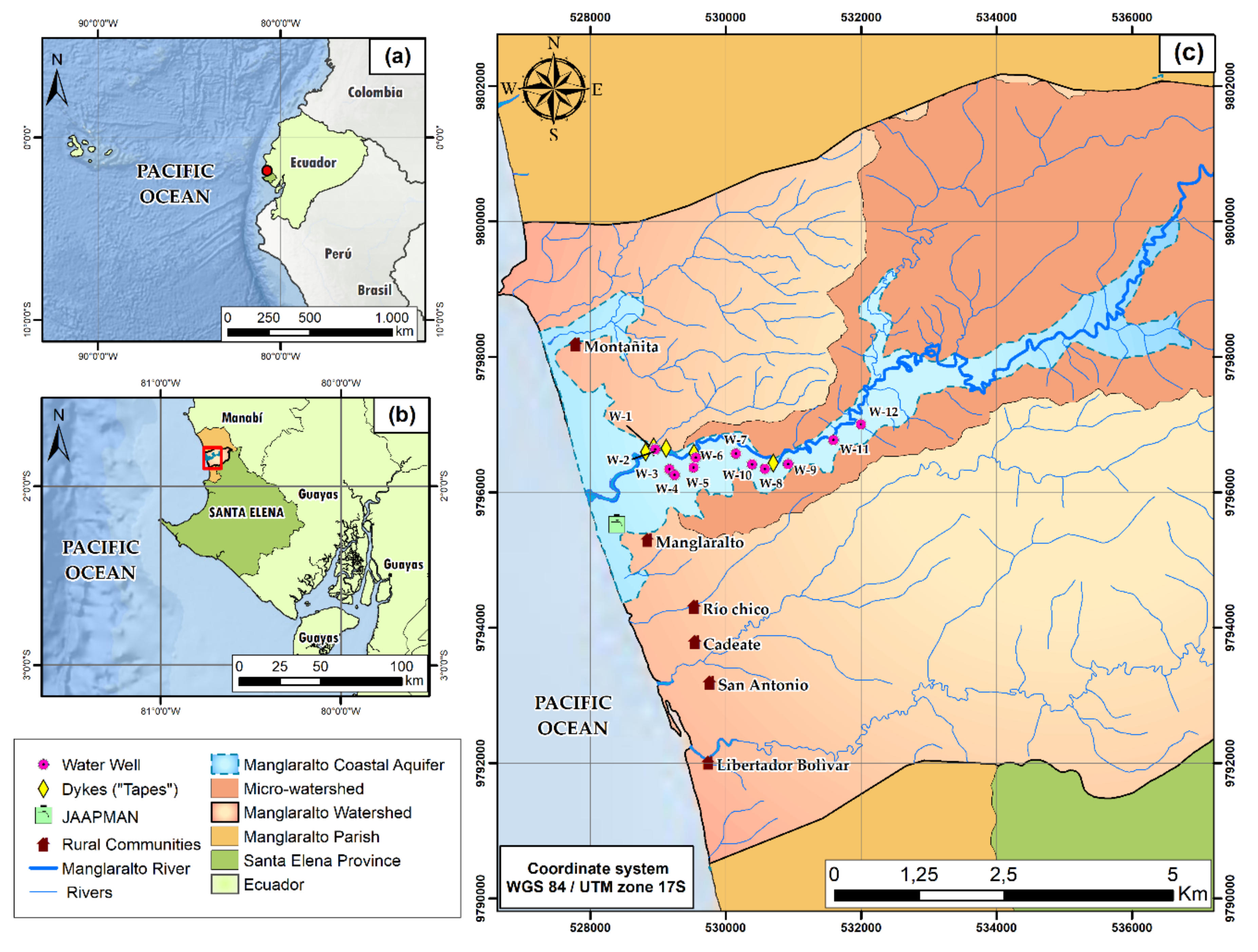
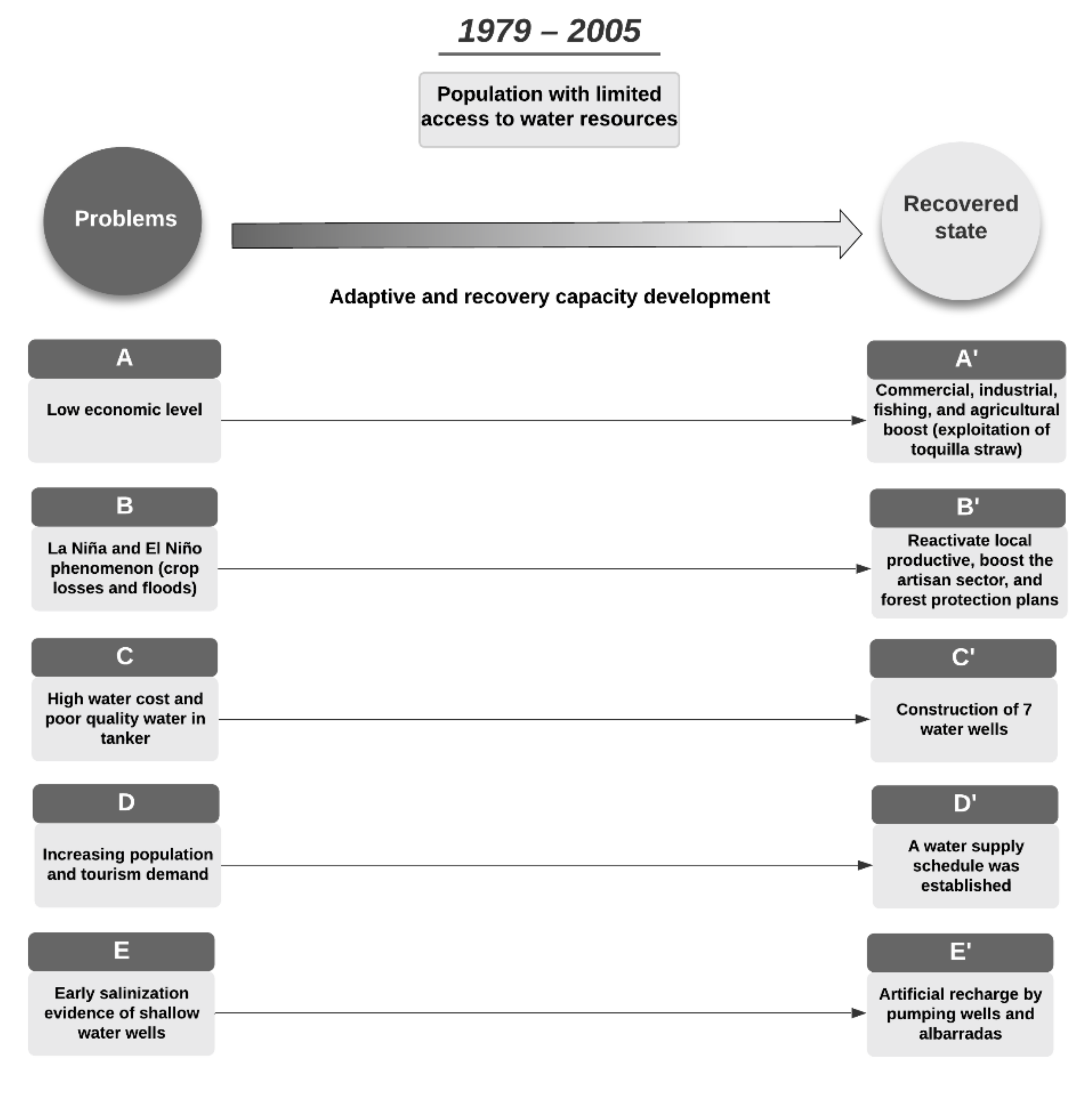
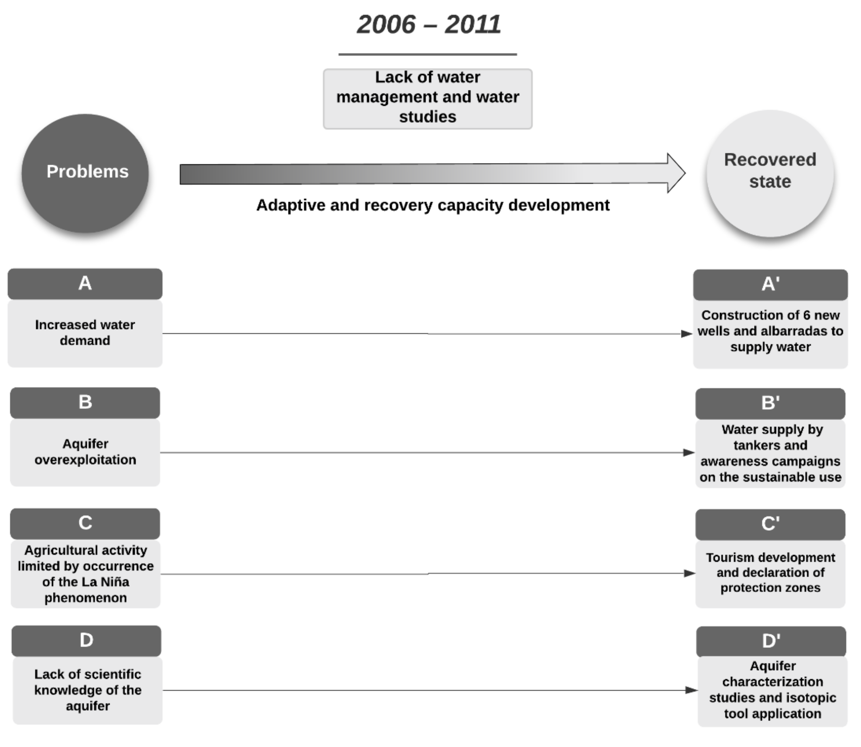
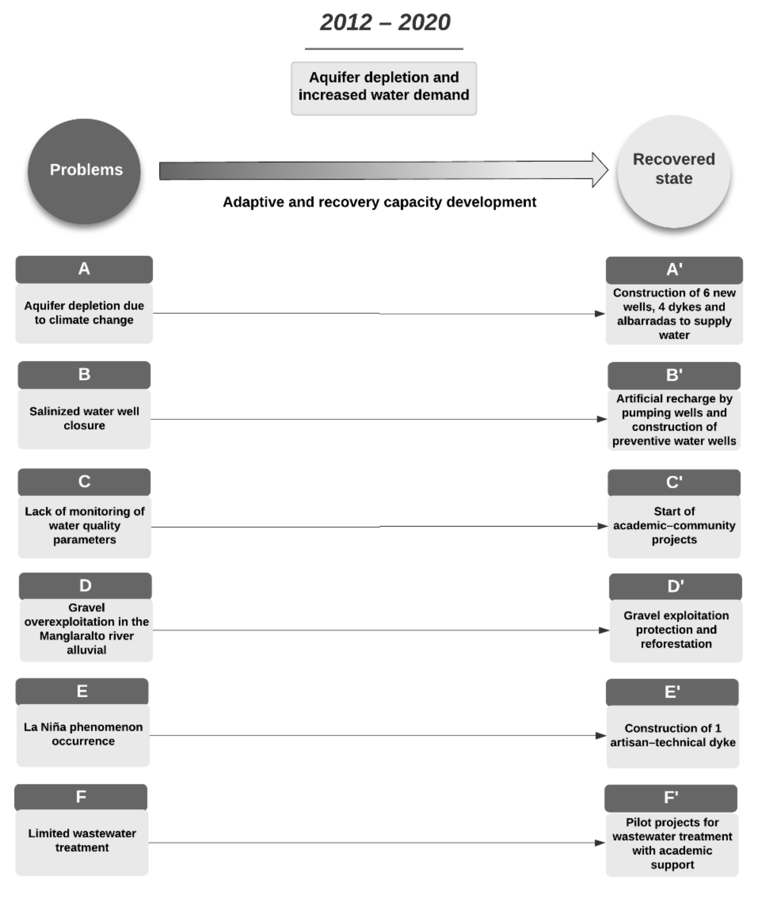
Case Study: Manglaralto
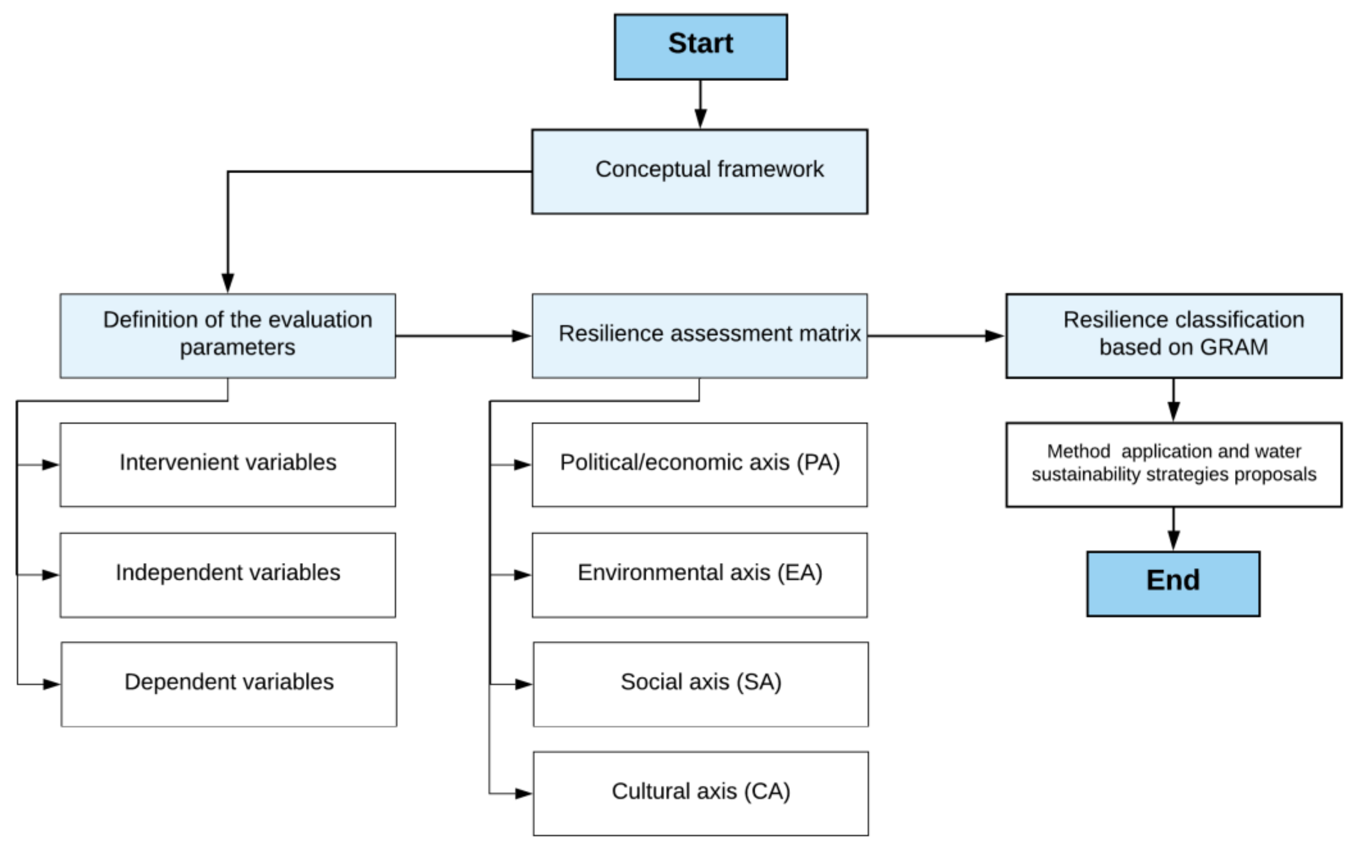
2. Materials and Methods
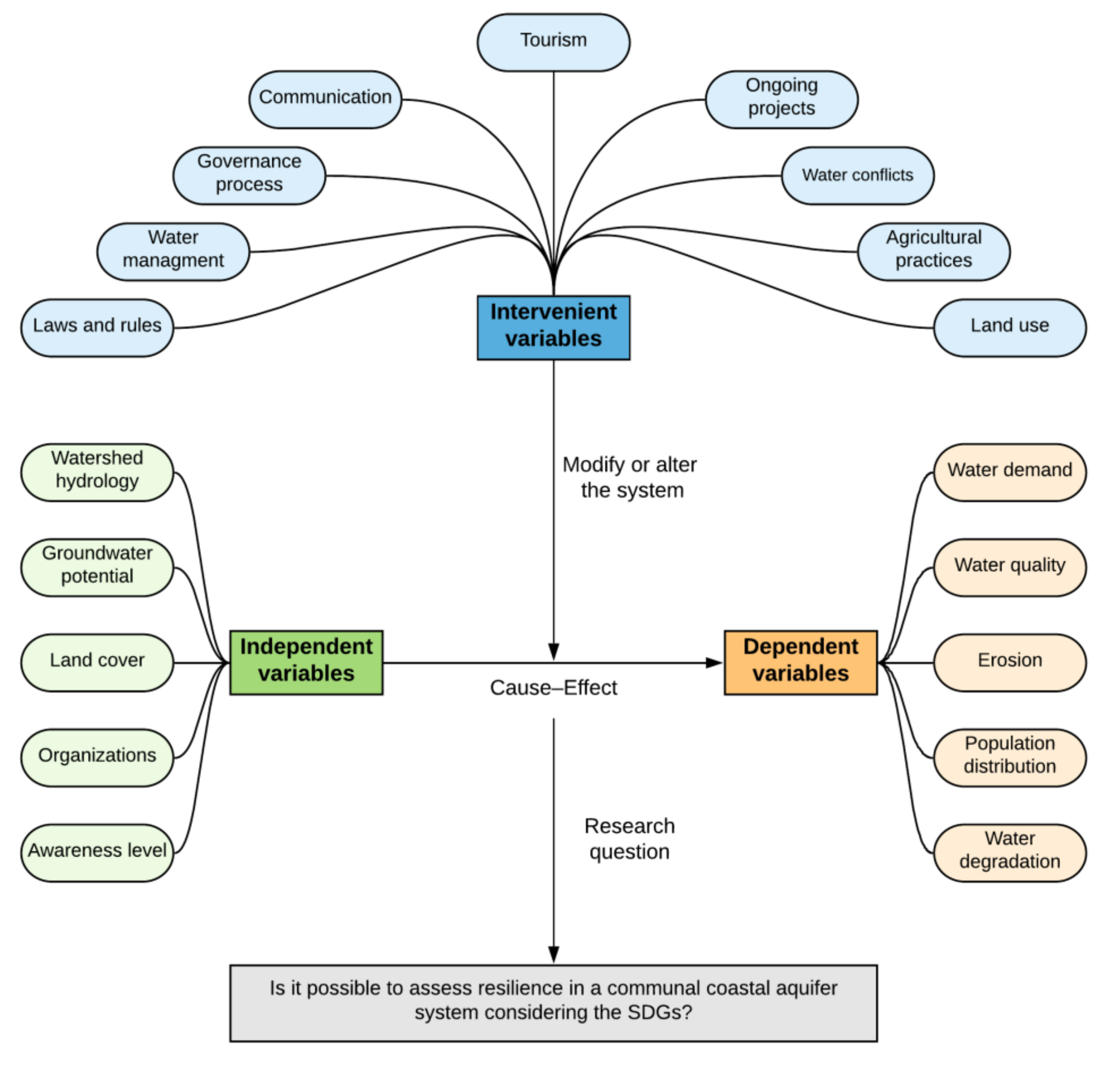
2.1. Conceptual Framework
2.2. Definitions of Evaluation Parameters
2.3. Resilience Assessment Matrix
2.3.1. Political/Economic Axis (PA)
- A.
- Water rate: helps to identify whether the price of water the population of a municipality/place has access to is in accordance with the current poverty level; compares family income to the national average.
- B.
- Management and community structure of the water system: identifies the entities/organizations that manage water and the degree of community participation.
- C.
- Water access: evaluates the proportion of the population of a municipality/place that has access to safe or potable water.
- D.
- Water use: determines the use of water extracted from the aquifer; that is, if the water is used only for basic needs or has more than one alternative use.
- E.
- Water quality: rates the policies for quality assurance and sanitation of groundwater and wastewater, respectively.
- F.
- Financial support: considers national and/or international financial support for hydric resource management plans to cope with climate change; relevant for measuring water resilience.
2.3.2. Environmental Axis (EA)
- A.
- Agriculture area: evaluates the type of agriculture and forestry in a municipality/place and verifies whether it meets the sustainability and resilience context.
- B.
- Freshwater quality monitoring: measures groundwater quality based on the existence and recurrence of parameter monitoring in the municipality/place.
- C.
- Wastewater management: rates the percentage of safely treated wastewater.
- D.
- Water estimation: identifies whether there is an estimate of water within a defined period that allows the community to preserve and ensure water measures.
- E.
- Ecosystem extent: evaluates the variation of the ecosystem extent over time and its impact on the resilience of a communal coastal aquifer system.
- F.
- Evapotranspiration/precipitation: assesses water use, artificial recharge, and environmental care measures to deal with hydric deficiency in a municipality/place.
- G.
- Monitoring of particulate matter: analyzes the implementation of clean industrial processes and technologies and the recurrence of monitoring of particulate matter to determine air pollution levels.
- H.
- Population affected by natural disasters: rates water shortage per hour in the event of a natural disaster.
- I.
- Protection areas: identifies areas of the ecosystem of a municipality/place where conservation and sustainable use are promoted to ensure hydric resources.
2.3.3. Social Axis (SA)
- A.
- Knowledge transfer: allows knowing the percentage of institutions that include development measures, adaptation, and mitigation of climate change in their teaching plans.
- B.
- Water rationing: indicates the period when a population receives limited water service due to demographic explosion; considerably affects the SA of the municipality or place.
- C.
- National and international alliances: benefits communal coastal aquifer system resilience; projects and agreements allow the implementation of new mechanisms for the conservation and sustainable use of water.
- D.
- Energy sources: reflects the contamination level of the municipality/place in terms of the percentage of the population that implements green energy sources.
- E.
- Community participation: evaluates the interaction of the water management entity with the community to apply methods of planning, management, and conservation of hydric resources in a municipality/place.
- F.
- Development plans: evaluates projected development plans for a determined period considering demographic explosion and hydric resource demand.
- G.
- Education: analyzes whether the population of the municipality/place has a basic level of education and academic support.
- H.
- Academic support: verifies the implementation of pilot projects considering water use, sustainable conservation, and wastewater treatment with corresponding academic support.
2.3.4. Cultural Axis (CA)
- A.
- Intercultural relationships: based on attendance to events related to water and evaluates if a municipality/place has established national or international alliances.
- B.
- Hydrological culture: based on the application of ancestral knowledge and provides solutions to problems of water shortages without overexploiting the resource, or if the community has help from the academy.
- C.
- Cultural diversity: analyzes the importance of solving water problems using awareness methods, with participation by the community, the water management body, and academia.
- D.
- Cultural holidays: evaluates the recurrence of holidays in a municipality/place; holidays with cultural basis in water are one of the main ways to raise public awareness of use, management, and conservation of water.
2.4. Resilience Classification Based on GRAM
3. Results
4. Discussion
- Strengthen the political–economic system of the community through alliances between the private entity in charge of the management and distribution of water and government entities at the local, regional, national, and international levels. This cooperation could generate economic support for management plans to cope with climate change and depletion of the aquifer.
- Promote the development of sustainable agriculture through the implementation of drip irrigation or intelligent solar irrigation systems to significantly reduce the amount of freshwater used and improve the management of the aquifer.
- Based on the success of pilot projects for the treatment of wastewater using green filters, it is essential to develop a large-scale project that enables the treatment of more than 50% of wastewater from Manglaralto, reduces pollution, and promotes its alternative use for the irrigation of specific species.
- Establish water conservation plans with estimates of at least 10 years to promote the application of ancestral knowledge and avoid salinization of the aquifer or a shortage of the resource for more than two days.
- Promote international alliances to raise funds for reforestation plans and establishment of protection zones to ensure the sustainability of ecosystems rich in flora and fauna and protect freshwater.
- Incorporate sustainable development and climate change adaptation and mitigation techniques in the educational system to boost the use of green energy and reduce pollution.
- Promote the resilient and sustainable practices of JAAPMAN and possibly replicate them in communities with similar situations.
- Maintain and strengthen the relationship between the community and academia through community awareness and participation in activities of projects that generate knowledge, management, and conservation techniques of the aquifer.
5. Conclusions
Supplementary Materials
Author Contributions
Funding
Acknowledgments
Conflicts of Interest
References
- Postel, S.L.; Daily, G.C.; Ehrlich, P.R. Human Appropriation of Renewable Fresh Water. Science 1996, 271, 785–788. [Google Scholar] [CrossRef]
- FAO Food and Agriculture Organization of the United Nations. AQUASTAT—FAO’s Global Information System on Water and Agriculture. Available online: www.fao.org/nr/water/aquastat/water_use/index.stm (accessed on 2 October 2020).
- Burek, P.; Satoh, Y.; Fischer, G.; Kahil, M.T.; Scherzer, A.; Tramberend, S.; Nava, L.F.; Wada, Y.; Eisner, S.; Flörke, M.; et al. Water Futures and Solution. Fast Track Initiative; IIASA: Laxenburg, Austria, 2016. [Google Scholar]
- Ercin, A.E.; Hoekstra, A.Y. Water footprint scenarios for 2050: A global analysis. Environ. Int. 2014, 64, 71–82. [Google Scholar] [CrossRef] [PubMed]
- Vörösmarty, C.J.; Green, P.; Salisbury, J.; Lammers, R.B. Global Water Resources: Vulnerability from Climate Change and Population Growth Contemporary Population Relative to Demand per Discharge. Science 2000, 289, 284–288. [Google Scholar] [CrossRef] [Green Version]
- Ferguson, G.; Gleeson, T. Vulnerability of coastal aquifers to groundwater use and climate change. Nat. Clim. Chang. 2012, 2, 342–345. [Google Scholar] [CrossRef]
- Crutzen, P.J.; Steffen, W. How Long Have We Been in the Anthropocene Era? Clim. Chang. 2003, 61, 251–257. [Google Scholar] [CrossRef]
- Steffen, W.; Broadgate, W.; Deutsch, L.; Gaffney, O.; Ludwig, C. The trajectory of the anthropocene: The great acceleration. Anthr. Rev. 2015, 2, 81–98. [Google Scholar] [CrossRef]
- Mekonnen, M.M.; Hoekstra, A.Y. Sustainability: Four billion people facing severe water scarcity. Sci. Adv. 2016, 2, 1–7. [Google Scholar] [CrossRef] [PubMed] [Green Version]
- Bakker, K.; Morinville, C. The governance dimensions of water security: A review. Philos. Trans. R. Soc. A Math. Phys. Eng. Sci. 2013, 371. [Google Scholar] [CrossRef]
- Dunn, G.; Brown, R.R.; Bos, J.J.; Bakker, K. Standing on the shoulders of giants: Understanding changes in urban water practice through the lens of complexity science. Urban Water J. 2017, 14, 758–767. [Google Scholar] [CrossRef]
- Farrelly, M.; Brown, R. Rethinking urban water management: Experimentation as a way forward? Glob. Environ. Chang. 2011, 21, 721–732. [Google Scholar] [CrossRef]
- Rosowsky, D.V. Defining resilience. Sustain. Resilient Infrastruct. 2020, 5, 125–130. [Google Scholar] [CrossRef]
- Timmerman, P. Vulnerability Resilience and Collapse of Society. A Review of Models and Possible Climatic Applications; University of Toronto: Toronto, ON, Canada, 1981. [Google Scholar]
- Holling, C.S. Resilience and Stability of Ecological Systems. Annu. Rev. Ecol. Syst. 1973, 4, 1–23. [Google Scholar] [CrossRef] [Green Version]
- Sharma, U.C.; Sharma, V. Groundwater sustainability indicators for the Brahmaputra basin in the northeastern region of India. In Sustainability of Groundwater Resources and Its Indicators; Webb, B., Hirata, R., Kruse, E., Vrba, J., Eds.; International Association of Hydrological Sciences: Wallingford, UK, 2006; p. 43. ISBN 1-901502-43-0. [Google Scholar]
- Brown, R.R.; Keath, N.; Wong, T.H.F. Urban water management in cities: Historical, current and future regimes. Water Sci. Technol. 2009, 59, 847–855. [Google Scholar] [CrossRef] [PubMed]
- Salinas Rodriguez, C.N.A.; Ashley, R.; Gersonius, B.; Rijke, J.; Pathirana, A.; Zevenbergen, C. Incorporation and application of resilience in the context of water-sensitive urban design: Linking European and Australian perspectives. Wiley Interdiscip. Rev. Water 2014, 1, 173–186. [Google Scholar] [CrossRef]
- Baird, J.; Dzyundzyak, A.; Plummer, R.; Bullock, R.; Dupont, D.; Jollineau, M.; Kubik, W.; Pickering, G.; Vasseur, L. Ecosystem perceptions in flood prone areas: A typology and its relationship to preferences for governance. Water 2016, 8, 191. [Google Scholar] [CrossRef] [Green Version]
- Baird, J.; Plummer, R.; Moore, M.L.; Brandes, O. Introducing Resilience Practice to Watershed Groups: What Are the Learning Effects? Soc. Nat. Resour. 2016, 29, 1214–1229. [Google Scholar] [CrossRef]
- Rijke, J.; Farrelly, M.; Brown, R.; Zevenbergen, C. Configuring transformative governance to enhance resilient urban water systems. Environ. Sci. Policy 2013, 25, 62–72. [Google Scholar] [CrossRef]
- Rockström, J.; Falkenmark, M.; Allan, T.; Folke, C.; Gordon, L.; Jägerskog, A.; Kummu, M.; Lannerstad, M.; Meybeck, M.; Molden, D.; et al. The unfolding water drama in the Anthropocene: Towards a resilience-based perspective on water for global sustainability. Ecohydrology 2014, 7, 1249–1261. [Google Scholar] [CrossRef]
- Shin, S.; Lee, S.; Judi, D.R.; Parvania, M.; Goharian, E.; McPherson, T.; Burian, S.J. A systematic review of quantitative resilience measures for water infrastructure systems. Water 2018, 10, 164. [Google Scholar] [CrossRef] [Green Version]
- White, E.K.; Peterson, T.J.; Costelloe, J.; Western, A.W.; Carrara, E. Can we manage groundwater? A method to determine the quantitative testability of groundwater management plans. Water Resour. Res. 2016, 52, 4863–4882. [Google Scholar] [CrossRef]
- Xu, L.; Kajikawa, Y. An integrated framework for resilience research: A systematic review based on citation network analysis. Sustain. Sci. 2018, 13, 235–254. [Google Scholar] [CrossRef]
- Mao, F.; Clark, J.; Karpouzoglou, T.; Dewulf, A.; Buytaert, W.; Hannah, D. HESS Opinions: A conceptual framework for assessing socio-hydrological resilience under change. Hydrol. Earth Syst. Sci. 2017, 21, 3655–3670. [Google Scholar] [CrossRef] [Green Version]
- Carpenter, S.; Walker, B.; Anderies, J.M.; Abel, N. From Metaphor to Measurement: Resilience of What to What? Ecosystems 2001, 4, 765–781. [Google Scholar] [CrossRef]
- Evans, B.; Reid, J. Dangerously exposed: The life and death of the resilient subject. Resilience 2013, 1, 83–98. [Google Scholar] [CrossRef] [Green Version]
- Todini, E. Looped water distribution networks design using a resilience index based heuristic approach. Urban Water 2000, 2, 115–122. [Google Scholar] [CrossRef]
- Fowler, H.J.; Kilsby, C.G.; O’Connell, P.E. Modeling the impacts of climatic change and variability on the reliability, resilience, and vulnerability of a water resource system. Water Resour. Res. 2003, 39. [Google Scholar] [CrossRef] [Green Version]
- Chen, T.Y.J.; Washington, V.N.; Aven, T.; Guikema, S.D. Review and Evaluation of the J100-10 Risk and Resilience Management Standard for Water and Wastewater Systems. Risk Anal. 2020, 40, 608–623. [Google Scholar] [CrossRef]
- Wong, T.H.F.; Brown, R.R. The water sensitive city: Principles for practice. Water Sci. Technol. 2009, 60, 673–682. [Google Scholar] [CrossRef] [Green Version]
- Herrera-Franco, G.; Alvarado-Macancela, N.; Gavín-Quinchuela, T.; Carrión-Mero, P. Participatory socio-ecological system: Manglaralto-Santa Elena, Ecuador. Geol. Ecol. Landsc. 2018, 2, 303–310. [Google Scholar] [CrossRef] [Green Version]
- Richey, A.S.; Thomas, B.F.; Lo, M.H.; Famiglietti, J.S.; Swenson, S.; Rodell, M. Uncertainty in global groundwater storage estimates in a Total Groundwater Stress framework. Water Resour. Res. 2015, 51, 5198–5216. [Google Scholar] [CrossRef]
- Falkenmark, M.; Rockstrom, J. Building Water Resilience in the Face of Global Change: From a Blue-Only to a Green-Blue Water Approach to Land-Water Management. J. Water Resour. Plan. Manag. 2010, 136, 606–610. [Google Scholar] [CrossRef]
- D’Odorico, P.; Laio, F.; Ridolfi, L. Does globalization of water reduce societal resilience to drought? Geophys. Res. Lett. 2010, 37, L13403. [Google Scholar] [CrossRef] [Green Version]
- Schelfaut, K.; Pannemans, B.; Van der Craats, I.; Krywkow, J.; Mysiak, J.; Cools, J. Bringing flood resilience into practice: The FREEMAN project. Environ. Sci. Policy 2011, 14, 825–833. [Google Scholar] [CrossRef]
- Head, B.W. Managing urban water crises: Adaptive policy responses to drought and flood in Southeast Queensland, Australia. Ecol. Soc. 2014, 19, 33. [Google Scholar] [CrossRef] [Green Version]
- Green, O.O.; Cosens, B.A.; Garmestani, A.S. Resilience in transboundary water governance: The Okavango River Basin. Ecol. Soc. 2013, 18, 23. [Google Scholar] [CrossRef] [Green Version]
- Lyon, S.W.; Goethals, P.; Schneider, P.; Dominguez-Granda, L.; Hampel, H.; Lam, N.; Nolivos, I.; Reinstorf, F.; Tejeda, R.C.R.; Vázquez, R.F.; et al. Improving water management education across the Latin America and Caribbean region. Water 2019, 11, 2318. [Google Scholar] [CrossRef] [Green Version]
- Peters, E.; Van Lanen, H.A.J.; Torfs, P.J.J.F.; Bier, G. Drought in groundwater—Drought distribution and performance indicators. J. Hydrol. 2005, 1, 302–317. [Google Scholar] [CrossRef]
- Hugman, R.; Stigter, T.Y.; Monteiro, J.P.; Nunes, L. Influence of aquifer properties and the spatial and temporal distribution of recharge and abstraction on sustainable yields in semi-arid regions. Hydrol. Process. 2012, 26, 2791–2801. [Google Scholar] [CrossRef]
- Ramos, T.; Pires, S.M. Sustainability Assessment: The Role of Indicators. In Sustainability Assessment Tools in Higher Education Institutions; Springer International Publishing: Cham, Switzerland, 2013; pp. 81–99. ISBN 9783319023755. [Google Scholar]
- Milman, A.; Short, A. Incorporating resilience into sustainability indicators: An example for the urban water sector. Glob. Environ. Chang. 2008, 18, 758–767. [Google Scholar] [CrossRef]
- Ioris, A.A.R.; Hunter, C.; Walker, S. The development and application of water management sustainability indicators in Brazil and Scotland. J. Environ. Manag. 2008, 88, 1190–1201. [Google Scholar] [CrossRef] [Green Version]
- Balkema, A.J.; Preisig, H.A.; Otterpohl, R.; Lambert, F.J.D. Indicators for the sustainability assessment of wastewater treatment systems. Urban Water 2002, 4, 153–161. [Google Scholar] [CrossRef]
- Polonenko, L.M.M.; Hamouda, M.A.; Mohamed, M.M. Essential components of institutional and social indicators in assessing the sustainability and resilience of urban water systems: Challenges and opportunities. Sci. Total Environ. 2020, 708, 135159. [Google Scholar] [CrossRef] [PubMed]
- van Leeuwen, C.J.; Frijns, J.; van Wezel, A.; van de Ven, F.H.M. City Blueprints: 24 Indicators to Assess the Sustainability of the Urban Water Cycle. Water Resour. Manag. 2012, 26, 2177–2197. [Google Scholar] [CrossRef]
- Staddon, C.; Sarkozi, R.; Langberg, S. Urban Water Governance as a Function of the ‘Urban Hydrosocial Transition’. In Freshwater Governance for the 21st Century; Karar, E., Ed.; Springer: Berlin/Heidelberg, Germany, 2017; Volume 6, pp. 81–102. ISBN 9783319433486. [Google Scholar]
- Willems, S.; Baumert, K. Institutional Capacity and Climate Actions; Organisation for Economic Co-operation and Development International Energy Agency (OECD): Paris, France, 2003. [Google Scholar]
- Dean, A.J.; Fielding, K.S.; Newton, F.J. Community knowledge about water: Who has better knowledge and is this associated with water-related behaviors and support for water-related policies? PLoS ONE 2016, 11, 1–18. [Google Scholar] [CrossRef] [PubMed] [Green Version]
- United Nations Sustainable Development Goals. Take Action for the Sustainable Development Goals. Available online: https://www.un.org/sustainabledevelopment/sustainable-development-goals/ (accessed on 2 October 2020).
- Brundtland, G. Our Common Future—Call for Action. Environ. Consevr. 1987, 14, 291–294. [Google Scholar] [CrossRef]
- United Cities and Local Governments. United Cities and Local Governments (UCLG) Policy Statement: “Culture: Fourth Pillar of Sustainable Development.”. Cult. Local Gov. 2011, 3, 161–164. [Google Scholar] [CrossRef] [Green Version]
- Peel, M.C.; Finlayson, B.L.; McMahon, T.A. Updated world map of the Köppen-Geiger climate classification. Hydrol. Earth Syst. Sci. 2007, 11, 1633–1644. [Google Scholar] [CrossRef] [Green Version]
- Strub, P.T.; Mesías, J.M.; Montecino, V.; Rutllant, J.; Salinas, S. Coastal ocean circulation off western South America. Glob. Coast. Ocean 1998, 273–313. [Google Scholar]
- Thiel, M.; Macaya, E.C.; Acuna, E.; Arntz, W.E.; Bastias, H.; Brokordt, K.; Camus, P.; Castilla, J.C.; Castro, L.; Cortés, M.; et al. The Humboldt Current System of northern and central Chile: Oceanographic processes, ecological interactions and socioeconomic feedback. Oceanogr. Mar. Biol. 2007, 45, 195–344. [Google Scholar]
- Montecino, V.; Lange, C.B. The Humboldt Current System: Ecosystem components and processes, fisheries, and sediment studies. Prog. Oceanogr. 2009, 83, 65–79. [Google Scholar] [CrossRef]
- Cornejo, C.; Haman, D.Z.; Espinel, R.L.; Jordan, J. Irrigation Potential of the TRASVASE System (Santa Elena Peninsula, Guayas, Ecuador). J. Irrig. Drain. Eng. 2006, 132, 453–462. [Google Scholar] [CrossRef]
- García-Garizábal, I. Rainfall variability and trend analysis in coastal arid Ecuador. Int. J. Climatol. 2017, 37, 4620–4630. [Google Scholar] [CrossRef]
- Instituto Nacional de Estadísticas y Censos (INEC). VII Censo de Población y VI de Vivienda: Sistema Integrado de Consultas. Available online: http://redatam.inec.gob.ec/ (accessed on 2 October 2020).
- Franco, G.H.; Quinchuela, T.G.; Macancela, N.A.; Mero, P.C. Participative analysis of socio-ecological dynamics and interactions. A case study of the Manglaralto coastal aquifer, Santa Elena-Ecuador. Malays. J. Sustain. Agric. 2017, 1, 19–22. [Google Scholar] [CrossRef]
- Gricelda, H.F.; Paúl, C.M.; Niurka, A.M. Participatory Process for Local Development: Sustainability of Water Resources in Rural Communities: Case Manglaralto-Santa Elena, Ecuador. In Handbook of Sustainability Science and Research; Leal Filho, E., Ed.; Springer: Cham, Switzerland, 2018; pp. 663–676. ISBN 9783319630076. [Google Scholar]
- Herrera-Franco, G.; Carrión-Mero, P.; Alvarado, N.; Morante-Carballo, F.; Maldonado, A.; Caldevilla, P.; Briones-Bitar, J.; Berrezueta, E. Geosites and Georesources to Foster Geotourism in Communities: Case Study of the Santa Elena Peninsula Geopark Project in Ecuador. Sustainability 2020, 12, 4484. [Google Scholar] [CrossRef]
- Herrera-Franco, G. Estudio Para Un Modelo de Gestión de Un Acuífero Costero, Mediante Metodologías Participativas y Análisis Geoestadístico en El Marco Del Desarrollo Local. Manglaralto, Ecuador. Ph.D. Thesis, Universidad Politécnica de Madrid, Madrid, Spain, 2015. [Google Scholar]
- Inocar. Available online: https://www.inocar.mil.ec/modelamiento/elnino/nino_cronologia.php (accessed on 2 October 2020).
- Herrera Franco, G.; Carrión Mero, P.; Briones Bitar, J. Management practices for a sustainable community and its impact on development, Manglaralto-Santa elena, Ecuador. In Proceedings of the 17thLACCEI International Multi-Conference for Engineering, Education, and Technology, Montego Bay, Jamaica, 24–26 July 2019; pp. 24–26. [Google Scholar] [CrossRef]
- Carrión, P.; Herrera, G.; Briones, J.; Sánchez, C.; Limón, J. Practical adaptations of ancestral knowledge for groundwater artificial recharge management of Manglaralto coastal aquifer, Ecuador. WIT Trans. Ecol. Environ. 2018, 217, 375–386. [Google Scholar] [CrossRef] [Green Version]
- Morante, F.; Montalván, F.J.; Carrión, P.; Herrera, G.; Heredia, J.; Elorza, F.J.; Pilco, D.; Solórzano, J. Hydrochemical and geological correlation to establish the groundwater salinity of the coastal aquifer of the Manglaralto river basin, Ecuador. WIT Trans. Ecol. Environ. 2019, 229, 139–149. [Google Scholar]
- Ilustre Colegio Oficial de Geólogos (ICOG). Tierra y Tecnología. Available online: https://www.icog.es/TyT/index.php/2020/02/la-siembra-y-cosecha-del-agua-en-iberoamerica-un-sistema-ancestral-de-gestion-del-agua-que-utiliza-soluciones-basadas-en-la-naturaleza/#:~:text=LaSiembrayCosechadelAguacomoSoluciónBasadaen,cosecharla)un (accessed on 6 August 2020).
- CYTED. Available online: http://www.cyted.org/?q=es/detalle_proyecto&un=975 (accessed on 6 August 2020).
- Carballo, F.M.; Brito, L.M.; Mero, P.C.; Aguilar, M.A.; Ramírez, J.T. Urban wastewater treatment through a system of green filters in the Montañita commune, Santa Elena, Ecuador. WIT Trans. Ecol. Environ. 2019, 239, 233–249. [Google Scholar] [CrossRef] [Green Version]
- Herrera, G.; Alvarado-Macancela, N.; Gavín-Quinchuela, T.; Carrión, P. Puesta en valor del sistema río-acuífero costero Manglaralto en el contexto del proyecto Geoparque Ancón-Santa Elena: Motor de desarrollo en áreas rurales de la parroquia Manglaralto, Ecuador. In Proceedings of the XVII Congreso Internacional Sobre Patrimonio Geológico y Minero, Almadén, España, 21–24 September 2017; SEDPGYM: Almadén, Spain, 2017; p. 61. [Google Scholar]
- Burton, I. Report on reports: Our common future. Environment 1987, 29, 25–29. [Google Scholar] [CrossRef]
- Berkes, F.; Colding, J.; Folke, C. Navigating Social-Ecological Systems: Building Resilience for Complexity and Change; Berkes, F., Colding, J., Folke, C., Eds.; Cambridge University Press: Cambridge, UK, 2003. [Google Scholar]
- Carpenter, S.R.; Westley, F.; Turner, M.G. Surrogates for resilience of social-ecological systems. Ecosystems 2005, 8, 941–944. [Google Scholar] [CrossRef]
- Walker, B.; Salt, D. Resilience Thinking: Sustaining Ecosystems and People in a Changing World; Island Pre.: Washington, DC, USA, 2006. [Google Scholar]
- American Society of Civil Engineers Task Committee on Sustainability. Sustainability Criteria for Water Resource Systems; Loucks, D.P., Gladwell, J.S., Eds.; Cambridge University Press: Cambridge, UK, 1998; ISBN 0784403317. [Google Scholar]
- Loucks, D.P. Sustainability implications for water resources planning and management. Nat. Resour. Forum 1994, 18, 263–274. [Google Scholar] [CrossRef]
- Loucks, D.P. Sustainable Water Resources Management. Water Int. 2000, 25, 3–10. [Google Scholar] [CrossRef]
- Mays, L.W. Water Resources Sustainability; No. 363.6; McGraw-Hill: New York, NY, USA, 2007. [Google Scholar]
- Chang, C.C.; DiGiovanni, K.; Mei, Y. Sustainability. Water Environ. Res. 2019, 91, 1129–1149. [Google Scholar] [CrossRef] [PubMed] [Green Version]
- Stern, N.; Stern, N.H. The Economics of Climate Change: The Stern Review; Cambridge University Press: Cambridge, UK, 2007. [Google Scholar]
- Intergovernmental Panel on Climate Change (IPCC). Climate Change 2007; Cambridge University Press: Cambridge, UK, 2007. [Google Scholar]
- Wang, C.H.; Blackmore, J.M. Resilience concepts for water resource systems. J. Water Resour. Plan. Manag. 2009, 135, 528–536. [Google Scholar] [CrossRef]
- Villarroya, F.; Aldwell, C.R. Sustainable development and groundwater resources exploitation. Environ. Geol. 1998, 34, 111–115. [Google Scholar] [CrossRef]
- Sandoval, R. A participatory approach to integrated aquifer management: The case of Guanajuato State, Mexico. Hydrogeol. J. 2004, 12, 6–13. [Google Scholar] [CrossRef]
- Shah, T. Taming the Anarchy: Groundwater Governance in South Asia; Routledge: New York, NY, USA, 2010; ISBN 9781936331598. [Google Scholar]
- Biswas, A.K. Water Policies in the Developing World. Int. J. Water Resour. Dev. 2001, 17, 489–499. [Google Scholar] [CrossRef]
- Newig, J.; Pahl-wostl, C.; Sigel, K. The Role of Public Participation in Managing Uncertainty in the Implementation of the Water Framework Directive. Eur. Environ. 2005, 343, 333–343. [Google Scholar] [CrossRef]
- Hammani, A.; Hartani, T.; Kuper, M.; Imache, A. Paving the way for groundwater management: Transforming information for crafting management rules. Irrig. Drain. 2009, 58, S240–S251. [Google Scholar] [CrossRef]
- van Steenbergen, F. Promoting local management in groundwater. Hydrogeol. J. 2006, 14, 380–391. [Google Scholar] [CrossRef]
- Yamamoto, S. Groundwater management in rice terraces: A case study of a lakeside community in Shiga Prefecture, Japan. Local Environ. 2008, 13, 449–460. [Google Scholar] [CrossRef]
- Mitchell, M.; Curtis, A.; Sharp, E.; Mendham, E. Directions for social research to underpin improved groundwater management. J. Hydrol. 2012, 448–449, 223–231. [Google Scholar] [CrossRef]
- Gupta, A.D.; Onta, P.R. Sustainable groundwater resources development. Hydrol. Sci. J. 1997, 42, 565–582. [Google Scholar] [CrossRef]
- Lerner, D.N.; Harris, B. The relationship between land use and groundwater resources and quality. Land Use Policy 2009, 26, S265–S273. [Google Scholar] [CrossRef]
- Mays, L.W. Groundwater Resources Sustainability: Past, Present, and Future. Water Resour. Manag. 2013, 27, 4409–4424. [Google Scholar] [CrossRef]
- Caldas, M.M.; Sanderson, M.R.; Mather, M.; Daniels, M.D.; Bergtold, J.S.; Aistrup, J.; Heier Stamm, J.L.; Haukos, D.; Douglas-Mankin, K.; Sheshukov, A.Y.; et al. Opinion: Endogenizing culture in sustainability science research and policy. Proc. Natl. Acad. Sci. USA 2015, 112, 8157–8159. [Google Scholar] [CrossRef] [Green Version]
- Dietz, T. Bringing values and deliberation to science communication. Proc. Natl. Acad. Sci. USA 2013, 110, 14081–14087. [Google Scholar] [CrossRef] [Green Version]
- Sivapalan, M.; Blöschl, G. Time scale interactions and the coevolution of humans and water. Water Resour. Res. 2015, 51, 6988–7022. [Google Scholar] [CrossRef] [Green Version]
- Salih, A. Qanats a unique groundwater management tool in arid regions: The case of Bam region in Iran. In Proceedings of the International Symposium on Groundwater Sustainability, Alicante, Spain, 24–27 January 2006. [Google Scholar]
- Yapa, K. Prácticas Dncestrales de Crianza de Agua: Una Guía de Campo: Estrategias Para Adaptarnos a la Escasez de Agua; United Nations Development Program - Ecuador (Undp Ecuador): Riobamba, Ecuador, 2013; ISBN 9789942988782. [Google Scholar]
- Girman, J.; van der Gun, J.; Haie, N.; Hirata, R.; Lipponen, A.; Lopez-Gunn, E.; Neupane, B.; Shah, T.; Vrba, J.; Wallin, B.; et al. Groundwater Resources Sustainability Indicator; IHP/2007/GW; Jaroslav, V., Annukka, L., Eds.; United Nations Educational, Scientific and Cultural Organization: Paris, France, 2007. [Google Scholar]
- Klemm, O.; Schemenauer, R.S.; Lummerich, A.; Cereceda, P.; Marzol, V.; Corell, D.; van Heerden, J.; Reinhard, D.; Gherezghiher, T.; Olivier, J.; et al. Fog as a Fresh-Water Resource: Overview and Perspectives. Ambio 2012, 41, 221–234. [Google Scholar] [CrossRef] [Green Version]
- Opare, S. Rainwater harvesting: An option for sustainable rural water supply in Ghana. GeoJournal 2012, 77, 695–705. [Google Scholar] [CrossRef]
- Meehan, K.; Ormerod, K.J.; Moore, S.A. Remaking Waste as Water: The Governance of Recycled Effluent for Potable Water Supply. Water Altern. 2013, 6, 67–85. [Google Scholar]
- Grunwald, A. Strategic knowledge for sustainable development: The need for reflexivity and learning at the interface between science and society. Int. J. Foresight Innov. Policy 2004, 1, 150–167. [Google Scholar] [CrossRef]
- Macneill, M. IAEA Helps Parched Santa Elena Find Water; IAEA Bulletin (Online): Vienna, Austria, 2011; Volume 53, pp. 12–13. [Google Scholar]


| SDG. | Target | SDG Indicators | Axes/Sub-indicators | Score |
|---|---|---|---|---|
| Political/Economic Axis (PA) | ||||
| 1 | 1.2 | 1.2.1 | A. Water rate | 1–4 |
| 5 | 5.1 | 5.1.1 | B. Management and community structure of water system | |
| 5.5 | 5.5.1 5.5.2 | |||
| 5.c | 5.c.1 | |||
| 6 | 6.b | 6.b.1 | ||
| 6 | 6.1 | 6.1.1 | C. Water access | |
| 6 | 6.2 | 6.2.1 | D. Water use | |
| 6.4 | 6.4.1 | |||
| 12 | 12.2 | 12.2.1 12.2.2 | ||
| 6 | 6.b | 6.b.1 | E. Water quality | |
| 13 | 13.b | 13.b.1 | F. Financial support | |
| Environmental Axis (EA) | Score | |||
| 2 | 2.4 | 2.4.1 | A. Agriculture area | 1–4 |
| 3 | 3.9 | 3.9.2 | B. Freshwater quality monitoring | |
| 6 | 6.3 | 6.3.2 | ||
| 6 10 11 12 | 6.3 10.4 11.6 12.4 | 6.3.1 10.4.1 11.6.1 12.4.2 | C. Wastewater management | |
| 6 | 6.3 | 6.3.2 | D. Water estimation | |
| 6.4 | 6.4.1 | |||
| 6.6 | 6.6.1 | |||
| 6 | 6.4 6.6 | 6.4.1 6.6.1 | E. Ecosystem extent | |
| 15 | 15.1 15.3 | 15.1.1 15.3.1 | ||
| 6 | 6.4 | 6.4.2 | F. Evapotranspiration/precipitation | |
| 9 11 | 9.4 11.6 | 9.4.1 11.6.2 | G. Monitoring of particulate matter | |
| 11 | 11.5 11.b | 11.5.1 11.b.2 | H. Population affected by natural disasters | |
| 13 | 13.1 | 13.1.1 13.1.3 | ||
| 14 | 14.5 | 14.5.1 | I. Protection areas | |
| 15 | 15.1 | 15.1.2 | ||
| 15.2 | 15.2.1 | |||
| 15.4 | 15.4.1 15.4.2 | |||
| 15.5 | 15.5.1 | |||
| 15.7 | 15.7.1 | |||
| Social Axis (SA) | Score | |||
| 4 11 | 4.7 11.3 | 4.7.1 11.3.1 | A. Knowledge transfer | 1–4 |
| 6 11 | 6.4 11.5 | 6.4.2 11.5.2 | B. Water rationing | |
| 6 17 | 6.a 17.6 | 6.a.1 17.6.1 | C. International alliances | |
| 7 11 | 7.2 11.3 | 7.2.1 11.3.2 | D. Energy sources | |
| 11 | 11.3 | 11.3.2 | E. Community participation | |
| 11 | 11.a | 11.a.1 | F. Development plans | |
| 11 | 11.3 | 11.3.1 | G. Education | |
| 15 | 15.b | 15.b.1 | H. Academic support | |
| Cultural Axis (CA) | Score | |||
| 6 17 | 6.a 17.6 | 6.a.1 17.6.1 | A. Intercultural relations | 1–4 |
| 11 | 11.3 | 11.3.2 | B. Hydrological culture | |
| 16 | 16.7 | 16.7.2 | C. Cultural diversity | |
| 16 | 16.7 | 16.7.2 | D. Cultural holidays |
| Axis/Sub-Indicators | Score |
|---|---|
| Political/Economic | |
| A. Water rate | |
| Laws/regulations for different water rates based on socioeconomic studies applied according to type of activity in the area (e.g., industry, tourism, agricultural, livestock, private residential areas, public residential area, the elderly care) | 4 |
| Two water rate laws based on socioeconomic studies: commercial and basic | 3 |
| Single basic water rate law based on socioeconomic studies | 2 |
| Single basic water tariff law that lacks socioeconomic studies (e.g., collection through barter and/or payment agreement) | 1 |
| B. Management and community structure of water system | |
| Water resource distribution carried out by: Inclusive national and private entities that involve community participation and gender equality | 4 |
| Inclusive national entities that involve community participation and gender equality | 3 |
| Inclusive private entities that involve community participation and gender equality | 2 |
| National or private entities that do not involve community participation and gender equality | 1 |
| C. Water access | |
| Percentage of population with access to potable water: | |
| 75–100% | 4 |
| 50–75% | 3 |
| 25–50% | 2 |
| 10–25% | 1 |
| D. Water use | |
| Freshwater extracted from aquifer is used for: | |
| Only basic needs (human use) | 4 |
| Basic needs and at least one alternative use | 3 |
| Basic needs and at least two alternative uses | 2 |
| Basic needs and more than three alternative uses | 1 |
| E. Water quality | |
| Operational policies and procedures preferably based on international standards that consider: | |
| All physical–chemical parameters to ensure quality and sanitation of surface water, groundwater, and wastewater, using techniques associated with sustainability (e.g., green filters, protected areas, reforestation) | 4 |
| All physical–chemical parameters to ensure quality and sanitation of surface water, groundwater, and wastewater | 3 |
| At least six of these parameters | 2 |
| At least three of these parameters | 1 |
| F. Financialsupport | |
| Direct national and international financial support for hydric resource management plans to cope with climate change | 4 |
| National or international financial support for hydric resource management plans to cope with climate change | 3 |
| National or international financial support for plans related/linked to management of hydric resources to cope with climate change | 2 |
| Limited national financial support for hydric resource management plans to cope with climate change | 1 |
| Axis/Sub-Indicators | Score |
|---|---|
| Environmental | |
| A. Agriculture area | |
| Percentage of agriculture and forestry area is used in a sustainable and resilient way that increases productivity, maintains ecosystems, and strengthens the ability to adapt to climate change: | |
| 75–100% | 4 |
| 50–75% | 3 |
| 25–50% | 2 |
| 10–25% | 1 |
| B. Freshwater quality monitoring | |
| Monthly | 4 |
| Quarterly | 3 |
| Semi-annual | 2 |
| Annual | 1 |
| C. Wastewater management | |
| Safe treatment of wastewater, by percentage: | |
| 75–100% | 4 |
| 50–75% | 3 |
| 25–50% | 2 |
| 10–25% | 1 |
| D. Water estimation | |
| Groundwater conservation estimates for: | |
| Next 10 years | 4 |
| Next 5 years | 3 |
| Next 3 years | 2 |
| At least 1 year | 1 |
| E. Ecosystem extent | |
| Extent of water-related ecosystem has: | 4 |
| Increased over time, and they have sustainable productive activities related to it Increased over time | 3 |
| Not changed over time | 2 |
| Decreased over time | 1 |
| F. Evapotranspiration/precipitation | |
| Given hydric deficit: | |
| Treated with measures to take advantage of groundwater, artificial recharge, and environmental awareness | 4 |
| Treated with at least two of these measures | 3 |
| Treated with at least one of these measures | 2 |
| There are proposals for environmental initiatives regarding groundwater | 1 |
| G. Particulate matter monitoring | |
| On-site adoption of clean and environmentally sound industrial technologies and processes and monitoring of PM10 and/or PM2.5 particulate matter: | |
| Monthly | 4 |
| Quarterly | 3 |
| Semi-annual | 2 |
| Annual | 1 |
| H. Population affected by natural disasters | |
| Water shortage for population due to natural disasters in the last decade: None | |
| Less than 24 h | 4 |
| 24–48 h | 3 |
| 48–94 h | 2 |
| I. Protection areas | 1 |
| Conservation and sustainable use of ecosystems rich in flora and fauna that ensure and protect freshwater, by percentage: | |
| 75–100% | 4 |
| 50–75% | 3 |
| 25–50% | 2 |
| 10–25% | 1 |
| Axis/Sub-indicators | Score |
|---|---|
| Social | |
| A. Knowledge transfer | |
| Percentage of local educational institutions that incorporate development, adaptation, and mitigation techniques for effects produced by climate change related to water in their teaching plans: | |
| 75–100% | 4 |
| 50–75% | 3 |
| 25–50% | 2 |
| 10–25% | 1 |
| B. Water rationing | |
| There is population growth, hydric resource reports water rationing, and: | |
| Service is already restored | 4 |
| Rationing remains until the middle of the dry season | 3 |
| Rationing remains throughout the dry season | 2 |
| Rationing remains to date | 1 |
| C. National and international alliances | |
| Participation of water management body in international and national alliance projects/agreements in the last decade: | |
| At least four of both | 4 |
| At least two of both | 3 |
| At least one of both | 2 |
| At least one international | 1 |
| D. Energy sources | |
| Percentage of population with green energy sources that reduce environmental pollution: | |
| 75–100% | 4 |
| 50–75% | 3 |
| 25–50% | 2 |
| 10–25% | 1 |
| E. Community participation | |
| Water management body, which operates on a regular and democratic basis: | 1 |
| Uses participatory methods with the community in planning, management, and conservation of resources | 2 |
| Communicates efficiently with the community in planning, management, and conservation of resources. | 3 |
| Does not involve community in planning and management of resources | 4 |
| F. Development plans | |
| Site implements development plans that integrate demographic projections and water resource needs for: | |
| Next 10 years | 4 |
| Next 5 years | 3 |
| Next 3 years | 2 |
| At least 1 year | 1 |
| G. Education | |
| Education level of users and administration is: | |
| Basic and strengthened with academic scientific support | 4 |
| Basic and they have permanent technical training about water | 3 |
| Basic and they have sporadic technical training about water | 2 |
| Basic | 1 |
| H. Academic support | |
| Academic support and pilot projects consider: | |
| At least sustainable water use, water conservation, and wastewater treatment | 4 |
| At least two of these aspects | 3 |
| At least one of these aspects | 2 |
| Academic support and pilot projects are proposed as initiatives | 1 |
| Axis/Sub-indicators | Score |
|---|---|
| Cultural | |
| A. Intercultural relationships | |
| Number of annual intercultural events on water and environment the water management body and community have participated in that allowed them to establish national and international alliances: | |
| More than two | 4 |
| Two | 3 |
| At least one | 2 |
| At least one that allowed them to establish national alliances | 1 |
| B. Hydrological culture | |
| Within the population, ancestral knowledge techniques implemented for water storage and recharging of the aquifer: | 4 |
| Provided a solution to overexploitation of the resource and water shortage; initiative was strengthened by technical design of academic counsel | 3 |
| Provided a solution to overexploitation of the resource and water shortage Partially solved overexploitation and water shortage | 2 |
| Eventual intercultural dialogue for awareness | 1 |
| C. Cultural diversity | |
| Solving water-related problems involves the following as pillars of awareness and application of participatory and educational methods for capacity development: | |
| Intercultural dialogue, water management body, and academia | 4 |
| Intercultural dialogue, water management body, or academia | 3 |
| Only intercultural dialogue | 2 |
| Eventual intercultural dialogue for awareness | 1 |
| D. Cultural holidays | |
| Number of annual holidays with cultural roots based on water and environment involving participation of the population and tourists: | |
| More than two | 4 |
| Two | 3 |
| At least one | 2 |
| No such holidays, but water assemblies held with inhabitants | 1 |
| Resilience Classification | Score |
|---|---|
| Very high resilience | 75–100 |
| High resilience | 50–75 |
| Resilience | 25–50 |
| Low resilience | 0–25 |
| Axis/Sub-Indicators | Score | ||||
|---|---|---|---|---|---|
| Political/Economic | E1 | E2 | E3 | E4 | E5 |
| A. Water rates | 3 | 3 | 3 | 3 | 3 |
| B. Management and community structure of water system | 2 | 2 | 2 | 2 | 2 |
| C. Access to drinking water | 3 | 4 | 3 | 4 | 2 |
| D. Water use | 3 | 1 | 3 | 1 | 4 |
| E. Water quality | 3 | 4 | 3 | 4 | 3 |
| F. Financial support | 1 | 1 | 1 | 1 | 1 |
| Avg/24 | 15 | ||||
| Environmental | Score | ||||
| A. Agriculture area | 2 | 3 | 1 | 3 | 2 |
| B. Freshwater quality monitoring | 4 | 4 | 4 | 4 | 4 |
| C. Wastewater management | 2 | 3 | 3 | 2 | 1 |
| D. Water estimation | 1 | 1 | 1 | 1 | 1 |
| E. Ecosystem extent | 4 | 4 | 4 | 4 | 3 |
| F. Evapotranspiration/precipitation | 4 | 3 | 4 | 4 | 3 |
| G. Particulate matter monitoring | 1 | 1 | 1 | 1 | 1 |
| H. Population affected by natural disasters | 1 | 1 | 1 | 1 | 1 |
| I. Protection areas | 1 | 2 | 1 | 1 | 1 |
| Avg/36 | 20 | ||||
| Social | Score | ||||
| A. Knowledge transfer | 2 | 2 | 2 | 3 | 3 |
| B. Water rationing | 1 | 1 | 1 | 1 | 1 |
| C. International alliances | 3 | 3 | 3 | 3 | 3 |
| D. Energy sources | 2 | 1 | 1 | 3 | 1 |
| E. Community participation | 4 | 4 | 4 | 4 | 3 |
| F. Development plans | 1 | 1 | 1 | 2 | 1 |
| G. Education | 4 | 4 | 4 | 4 | 4 |
| H. Academic support | 4 | 4 | 4 | 4 | 4 |
| Avg/32 | 21 | ||||
| Cultural | Score | ||||
| A. Intercultural relationships | 3 | 4 | 3 | 3 | 3 |
| B. Hydrological culture | 4 | 4 | 4 | 4 | 4 |
| C. Cultural diversity | 4 | 4 | 4 | 4 | 4 |
| D. Cultural holidays | 2 | 1 | 2 | 2 | 2 |
| Avg/16 | 13 | ||||
| E1–E5, evaluators 1–5. | |||||
| Axis | Score |
|---|---|
| A. Political/Economic | 15 |
| B. Environmental | 20 |
| C. Social | 21 |
| D. Cultural | 13 |
| 62.33 |
© 2020 by the authors. Licensee MDPI, Basel, Switzerland. This article is an open access article distributed under the terms and conditions of the Creative Commons Attribution (CC BY) license (http://creativecommons.org/licenses/by/4.0/).
Share and Cite
Herrera-Franco, G.; Carrión-Mero, P.; Aguilar-Aguilar, M.; Morante-Carballo, F.; Jaya-Montalvo, M.; Morillo-Balsera, M.C. Groundwater Resilience Assessment in a Communal Coastal Aquifer System. The Case of Manglaralto in Santa Elena, Ecuador. Sustainability 2020, 12, 8290. https://0-doi-org.brum.beds.ac.uk/10.3390/su12198290
Herrera-Franco G, Carrión-Mero P, Aguilar-Aguilar M, Morante-Carballo F, Jaya-Montalvo M, Morillo-Balsera MC. Groundwater Resilience Assessment in a Communal Coastal Aquifer System. The Case of Manglaralto in Santa Elena, Ecuador. Sustainability. 2020; 12(19):8290. https://0-doi-org.brum.beds.ac.uk/10.3390/su12198290
Chicago/Turabian StyleHerrera-Franco, Gricelda, Paúl Carrión-Mero, Maribel Aguilar-Aguilar, Fernando Morante-Carballo, María Jaya-Montalvo, and M.C. Morillo-Balsera. 2020. "Groundwater Resilience Assessment in a Communal Coastal Aquifer System. The Case of Manglaralto in Santa Elena, Ecuador" Sustainability 12, no. 19: 8290. https://0-doi-org.brum.beds.ac.uk/10.3390/su12198290