Re-Inventing Water–Ground Relations in Landscape Architecture Projects


DiAP, Department of Architecture and Design and PhD Program in Landscape and Environment, Sapienza University of Rome, 00185 Rome, Italy
*
Author to whom correspondence should be addressed.
Sustainability 2020, 12(24), 10358; https://0-doi-org.brum.beds.ac.uk/10.3390/su122410358
Submission received: 14 October 2020
/
Revised: 25 November 2020
/
Accepted: 4 December 2020
/
Published: 11 December 2020
(This article belongs to the Special Issue Soil Ecosystem Services, Land Planning, Landscape Design and Management)
Abstract
:In recent decades, the relationship between soil and water has been at the center of many landscape architecture projects and, more in general, of urban transformation. With an ever-increasing recurrence, the interventions reflect on the positive effects of this dialectic, to the point of making it the constitutive element, both in terms of morphologies and of the reciprocal conditions of quality and resilience, combining ecosystem effects and cultural values. This paper thus examines some cases where the use of these elements has assumed the role of “raw material” in those design processes where they are called to specifically question the relationship between nature and human settlements. Three case studies, which with different declinations represent turning points and paradigmatic passages in this context, are here analyzed: the Cultuurpark Westergasfabriek in Amsterdam, the Cheong Gye Cheon canal in Seoul, and the Candlestick Park in the San Francisco Bay.
1. Introduction
Among the positive visions for cities and metropolitan areas for the third millennium, the work on the dialectic between water and soil plays an increasingly important role in all landscape design activities at various levels. Whether they are connected to urban transformation processes, to the restoration of conditions of naturalistic resources and landscape quality, or to the prevention of risks deriving from climate change, many projects are increasingly investigating these relationships in terms of morphology, spatial layout, or further intrinsic qualities that are analyzed on a scientific, aesthetic, and social level [1,2,3].
The numerical incidence of these studies is increasing, both in anthological publications [4] and in theoretical contributions on the practices of landscape design [5]. For instance, in the last two editions of the Barcelona International Landscape Biennial, almost all finalist projects centrally focused on these themes [6]. The same happens in large project databases, such as Landezine and others [7].
While there has been an increase in the production of projects that focus on the water–soil relationship, at the same time these topics have produced new developments in both basic research and urban management theories and protocols. Without neglecting the implications, the topic of water involves on an ethical–political, economic [8], and ecological level [9], in scientific urban studies water has recently re-conquered the contemporary agenda in urbanism [10], after the urbanistic culture of modernity, at the turn of the 19th and 20th centuries had dealt with the issue, entrusting it exclusively to civil and hydraulic engineers, as a question of sanitizing the city [11].
Such way of dealing with the relationship between water and urbanity had disappeared water from the urban landscape, channeling it into pipelines, sewer systems, or simply pushing planners to “turn their backs” on the great rivers that crossed the cities.
On the protocols of sustainable water management in urban areas, the same academic circles that gave rise to the theories of landscape urbanism have seen the emergence of further models such as water cities and water urbanism, and on the technical level a large production of studies on drainage, collection, and reuse of rainwater [12]. All these experiences represent today’s significant steps in our discourse. In Australia, starting in the early 1990s—through Water Sensitive Urban Design, an integrated water management strategy—protocols have taken shape [13].
All these experiences represent today significant passages of our discourse and can be considered as possible guidelines [14] and “catalogs” of good practices [15] now very developed.
The case studies were taken in examinations in this paper to reflect on the positive effects of the dialectic between water and ground in the physical and spatial reconfiguration of sites that are either abandoned or undergoing a transformation: the dyad is assumed as central. They are actions for the construction of morphologies and the enhancement of resilience, for the improvement of reciprocal quality conditions, for the combination of ecosystemic repercussions and cultural values [16]. On the one hand, water is always studied starting from a double posture, embedded in the history of relations between society and water: between scarcity and excess, desire and concern, the need for availability and supply, and the need for removal and treatment. On the other hand, the work on soil and land, in its double meaning and on its qualities and forms, acquires new declinations also to improve the production of ecosystem services. It seems that the Chinese concept of the term landscape, shan-shui—which expresses the dialectic between water and mountains, or water and earth—is shifting from being the object of historical–philosophical study of the garden, landscape, and environment scholars [17], to rise through different disciplines to represent a new possible paradigm of sustainability of landscape design tout court [18].
This design practice initially focused on a privileged category of spaces: since the late Eighties and in part of the Nineties, landscape projects were often used as devices for the redevelopment of areas in consolidated fabrics that had been abandoned due to the delocalization of production [19]. Already in this phase, the focus progressively shifted towards the redevelopment of more extensive systems: waterfronts, long used for heavily polluting industrial activities and later abandoned; rivers and urban watercourses, which in the modern city often represented “a backdrop”; finally, friches, or terrains vagues, i.e., all those spaces resulting from growth within or at the margins of the fabrics, the so-called urban fringes. In this sense, since the beginning of the Nineties, the post-industrial city has returned its gaze towards these places, starting to recover their value and space, understanding the great potential of these ecosystems for the improvement of the quality of life along with the physical and psychological well-being of inhabitants [20]. These spaces have been transformed into places for leisure and sports, but also for work, commercial, and cultural activities. They have been transformed to reconstruct pre-existing landscapes or to invent new terrains through the reintroduction of original plant systems, or even in attempts to create new forms of urban wilderness and green infrastructure in city centers [21].
Through the analysis of three case studies considered turning points in landscape design, the paper thus questions the relationship between water and soil in landscape architecture interventions. The focus will be both on the production of ecosystem services, considered in their broadest sense extended to cultural, recreational, and identity values, and on the processes of transformation of urban and peri-urban areas, in terms of the derivative effect in interventions aimed at creating anthropized spaces and public use.
The method of case study analysis will obviously be more descriptive/comparative than purely scientific. The paper will therefore highlight how devices and scientific studies on water–soil issues are able, in excellent projects, to overcome the mere technical application of these, to highlight their cultural values and the potential for public use. The methodology used is focused on the description of which compositional and perceptive strategies of the project have also been made possible through the application of technical assumptions taken in reference, and how these can directly or indirectly influence similar environmental sustainability objectives. This interpretation represents at the same time the search for aesthetic, social, and environmental qualities in the broadest sense of the term, and the start point of some further investigation of some scientific areas, basing on the positive evidence generated by the projects.
2. Cultuurpark Westergasfabriek, the Sustainable Design of Water
The Cultuurpark Westergasfabriek in Amsterdam can be considered a masterpiece among the case studies where the water–soil dialectic is deeply expressed. This intervention recapitulated the advancements in these fields of study from the 1970s and 1980s, projecting them into the future. At the same time, it clearly illustrates the importance of landscape architecture as the main driving force behind a process of regeneration of a disused and degraded industrial area, where the project represents an evolutionary phenomenon that is still ongoing today [22].
2.1. A History of Urban Regeneration through Landscape Design
The intervention tells the story of the site and its transformation, from a disused space to a place of high urban sustainability and sharing. Even before the beginning of the work, it was considered an exemplary case in the creation of urban attractors and in the strategies dedicated to the creation of cultural clusters [23].
The area was a former gas production plant built at the end of the 19th century and abandoned in 1967. The site had become central in relation to the urban core, but was nevertheless excluded for a long time from public use and redevelopment processes. This separation was partly due to the high level of soil pollution, to the extent that it was internationally considered a controversial hotspot. Furthermore, it was rejected for having long been the site of different occupation phenomena, with cultural initiatives taking place alongside illegal activities.
To the East, the Westergasfabriek Park is connected with a 19th-century five hectares park, the Westerpark; to the West, with the Tuinpark Nut en Genoegen, a garden-city with socialist imprint. Settled on a polder in 1909, this latter area is structured with a network of canals, small houses, and private and shared gardens. Today the Westergasfabriek, together with the Westerpark and the connected wetland, forms a system of about 50 hectares of an urban park (Figure 1). From its closure in 1967 to the decision in 1992 on an international competition for the creation of a park, this area has always been at the center of the administration’s attention [22].
Its reclamation had been evaluated with amounts that exceeded the local and national financial possibilities; in 1990 an estimate claimed that the cost would reach the current equivalent of about 400 million euros.
In a period in which international studies on reclamation produced some first syntheses [24], this area had been extensively studied by the international scientific community due to the risk conditions concerning the various pollutants and the subsequent remediation strategies. From different points of view, everyone agreed on the need to proceed through interventions differentiated in terms of methods and timeframe, rather than through a radical, unitary intervention. The area was originally classified among the sites with the highest level of pollution and included by Dutch legislation before 1995 in “Level C - Required, complete cleanup”. Instead, the 1995 “Soil Protection Act” introduced the concept of “Maximum Permissible Risk”, MPR, which links the degree of decontamination action to the intended uses of the soil, creating some degree of ambiguity. The Environmental Protection Agency (EPA) 2008 report stated:
Under the new 1995 Act, the C-level has been revised to include an intermediate standard that does not automatically require full remediation to background levels. Cleanup standards have been developed with maximum permissible risk (MPR) levels based on land-use. […] If the MPR is not exceeded, under Dutch law a full cleanup is not required. Environmental regulators may, however, encourage supplemental steps so that pollution is not too close to the MPR levels.[25]
At the beginning of the Nineties, the administration appointed hydraulic engineer Evert Verhagen as project manager of Westergasfabriek. He would work for about fifteen years on the complex balance between redevelopment and economic impact, between real estate development and strong associative drives, to create a large park as a complex machine, capable of renewing without making a clean slate, following an overall idea of regeneration. Verhagen explained that public opinion was in favor of maximizing the surface area of the park, thus requiring larger amounts of demolition.
Parts of the buildings were reused by introducing “transitory forms of use” for economic, cultural, and artistic activities, also with the intention of reducing the presence of squatters and spontaneous associations. Verhagen tried to outline a process in which the resulting resources constituted the prerequisite for its development [26]. The success of the initiative allowed the construction of the program of activities and uses that today form the basis of the system, although several voices have denounced how this process has led to the gentrification of the area [27]. On the temporary uses, Verhagen states:
The main difficulty was to find temporary use for such a huge site considering the soil contamination. But it was imperative that we buy time until a long-term plan had been devised” […] “When we started to use the first building for cultural activities, it was not with the idea that this would be its final usage. However, it proved so successful that we decided to incorporate these cultural events into the long-term plan.[28]
2.2. The Design of the Park
In 1997, the two-stage international competition for the “Masterplan of the Westergasfabriek area” was won by Kathryn Gustafson—together with Francine Houben of Mecanoo for her work on existing architecture—with a project titled “Changement” (Figure 2).
The project develops along two parallel paths, starting in the East from a square next to the existing park meant to link the area located to the West. The urban route runs alongside the canal and provides access to the activities located in the historic buildings (Figure 3). The second route organizes the park area, leading up to the Tuinpark Nut en Genoegen [29,30].
Second, progressive actions of soil cleaning with intensive bio-remediation systems were carried out on the park areas, through a sequence of active waters that have eventually become the well-known characteristic of the park. The level of pollution was constantly monitored and reported in a special record. Thanks to these devices, the quality of the soil progressively improved even at the deepest layers [31]. Due to its unusual character in an urban context, in the park, the system of phyto-purification of wetlands became attractive and of interest at both scientific–didactic and perceptive levels [32].
The park is organized in different areas. The entrance square is formal, planted following a regular grid. From there, the urban path opens out towards the Haarlemmervaart canal and the city, forming a system of public spaces that enhances the new City of Arts, integrating the buildings, the gardens with refined ornamental collections, up to the two large reservoirs, transformed into visible purification basins with collections of grasses that filter the percolating water.
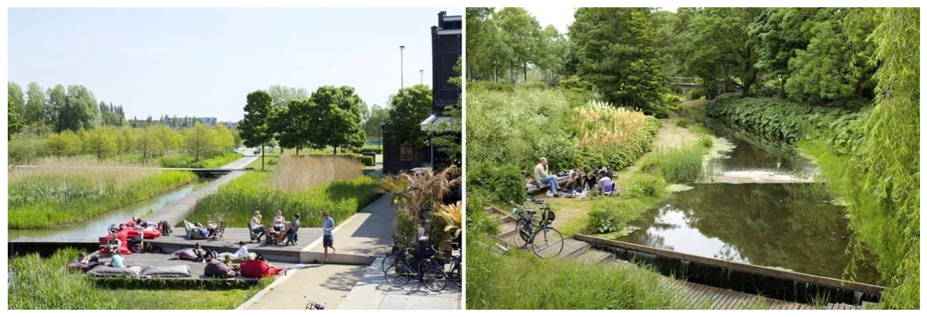
The path in the park, on the other hand, runs alongside the railway with a pedestrian and cycle path and a waterway. Along with this, the soil is modeled in the form of a slope intended for large public events. Next to the path runs the “Event Lake” (Figure 4), a progressively larger waterway that becomes a lake and ends with the “Wet Gardens” (Figure 5), virtuosity in the ornamental use of plant structures typical of wetlands. The park is like a huge environmental machine, where the story of the relationship between water, land, and vegetation becomes a poetics (Figure 6). There is wide use of nature-based solutions, expressed with a range extending from the maximum naturality to the greatest level of artifice.
The theme of water has always been at the center of Gustafson’s work: the use of plastic forms, with a very refined and innovative design, succeeds in making sense of places in an elegant and rarely self-celebratory way [33]. Here, it seems that Gustafson intended to favor the comparison with the great dimension and the strong civic character of the area. She skillfully adopts the deep-rooted Dutch knowledge of hydraulic engineering and the innovations experimented since the 1980s on the applications of constructed wetlands, with her consolidated propensity for “water design” in urban environments, achieving with this work one of the major stylistic and technical expressions of these themes.
3. Seoul’s Cheong Gye Cheon Canal: A Paradigm of Urban Sustainability
The 2005 project to recover the Cheong Gye Cheon canal is undoubtedly one of the fundamental moments in the process of conversion of the South Korean capital from a productive and technological city to a metropolis that makes its ecosystem one of the main keys to urban identity.
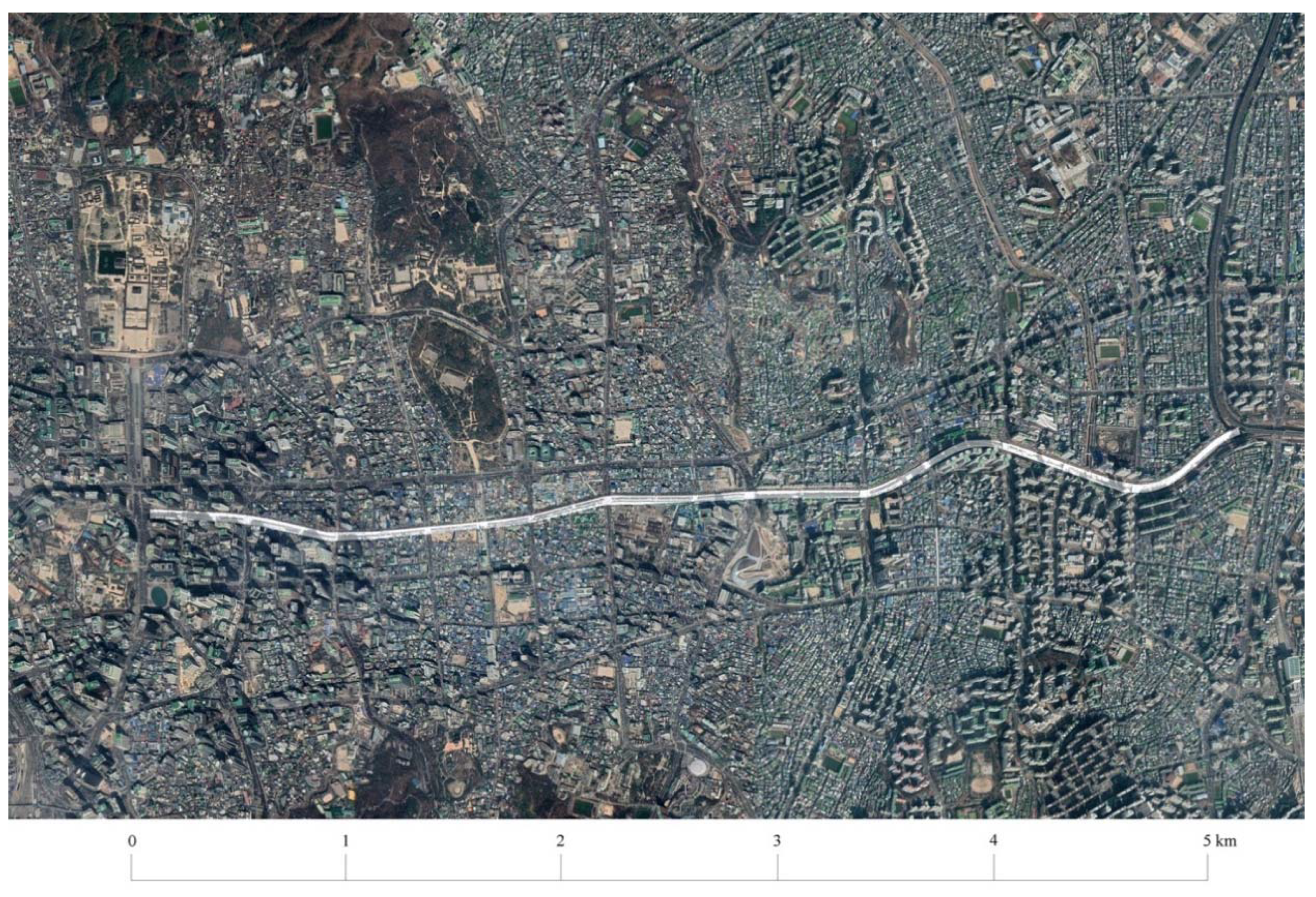
The plan to recover the natural habitat of the Seoul Canal is a sustainable redevelopment project (SeoAhn Total Landscape) that, through the creation of green infrastructure, represents an exemplary experience. This radical transformation has involved an extensive portion—about 6 km—of the urban soil of the city (Figure 7).
Although the stream is contained in an average width of around 30 m, it is converted from artificial to natural, from impermeable to permeable, from dividing to an aggregating place, from private to public use. The project has produced clear local benefits and triggered virtuous dynamics at the metropolitan scale, in terms of land planning and landscape design and management, but also with an outlook toward a general improvement in the quality of urban life [34], thanks to the benefits offered by the increase in ecosystem services, and the consequent effects on public health [35]. Before being a waterway, the Cheong Gye Cheon is designed as a public promenade that encourages sports, physical activity, and socializing, providing places to rest and to hold events.
3.1. The Reconversion of Urban Highways into Parks
This intervention is part of a recent tradition of projects that have buried urban highways to minimize the damaging effects of traffic (noise and air pollution) and build public parks. The transformation of Rio Madrid in the Spanish capital (2003–2007), perhaps the best-known case, has allowed the city, through the undergrounding of a 10 km-portion of the urban ring road (M-30), to acquire a large urban park on both banks of the Manzanares river.
Similar strategies were undertaken at the beginning of the new millennium in Europe (Oslo, Dublin) and the United States (Boston’s famous Big Dig, which converted the city’s main highway into a 5,6 km long tunnel, above which public spaces and urban gardens could be created) [36].
The peculiarity of the South Korean case study is that it is not the undergrounding of a freeway artery, but its complete removal [37]. The Cheong Gye Cheon is also the first example of its kind in Asia, placing South Korea in a leading position if compared to other countries on the continent in terms of developing an innovative approach to supporting a new techno-green economic paradigm.
3.2. Mountains and Water: The Original Landscape of Seoul and Its Urban Form
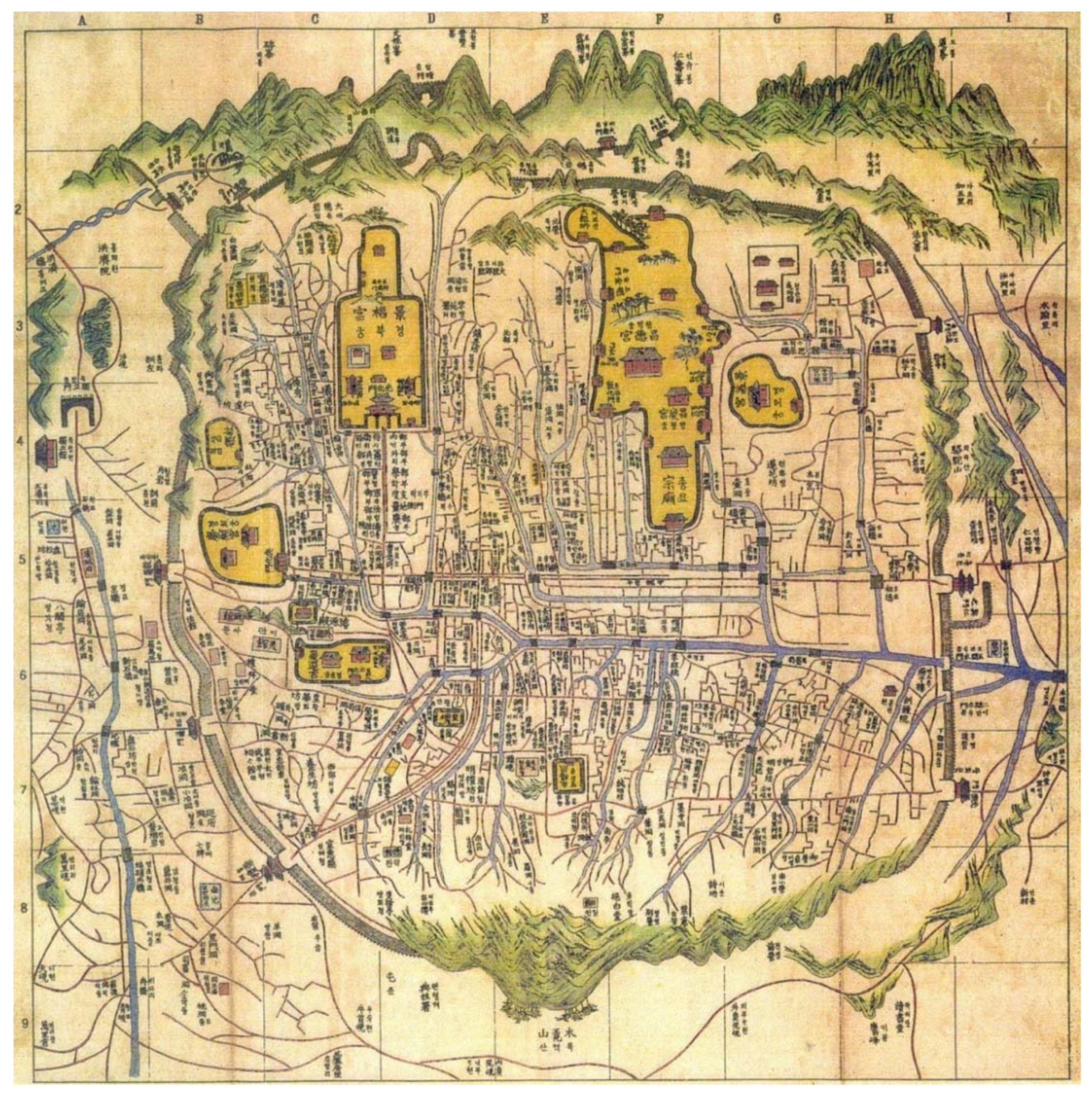
The conformation of the natural site where the South Korean capital stands—characterized by a precise orientation in the territory, the presence of a complex circle of mountains, and a large river to the south that collects the waterways—represents the perfect context for the foundation of a city. These qualities, of a protected and “propitious” place, respond paradigmatically to the concepts of the pungsu-jiri-seol (“wind-water-earth-principles theory”), the Korean version of the geomantic doctrine of the Chinese feng-shui (wind–water). Seoul, founded in 1394 as the new capital of the Joseon dynasty, rises in a carefully chosen natural place, not “shaped” by human action. This ideal condition was then improved by the construction of the artificial canal of the Cheong Gye Cheon, dug in the 14th century to collect the waters of the reliefs located on the four primary orientations (symbolizing mythological animals defending the site) and make them flow into the great Han River (Figure 8). The origin of the city, thus linked to the landscape, has always been intimately connected to the very idea that the Koreans still have of their capital. We could say that, in Seoul, the landscape has been the generating element of the urban form.
The project also “reveals” other important features of the city. For example, the idea of juxtaposing delimited and protected places with large and dilated spaces, as in the case of the alternation between the small street fabric and the large voids of the imperial palaces. The Cheong Gye Cheon displays this twofold nature, being at once an extended “environmental corridor”, and limited to an almost intimate and secret place. Even though it is a very thin “linear park” structuring and connecting important parts of the city, in many places it affords spaces and atmospheres typical of the garden of a traditional house [38].
3.3. Seoul Sustainable Metropolis: An Integrated Strategy
With 17,000 inhabitants per square km, Seoul is one of the most densely populated cities in the world and is considered one of the most sustainable metropolises on the planet. The conquest of this particular condition of the eco-friendly city is the result of decades of far-sighted urban policies: the creation of a green belt on a territorial scale [39], continuous investment in public mobility, integration between different modes of transport (metro, bus, ferry, bike), and the protection and “reconstruction” of the landscape of mountains and water [40].
It has also worked for the constant promotion of physical activity in the city as an instrument of wellbeing for the population: a clear example is the recently completed pedestrian path along the 19 km of the ancient city walls, restored and included in 2012 in the UNESCO World Heritage List. The strategy of use and enhancement of the mountains is complementary to the master plan for the Hangang Renaissance Project, a major redevelopment plan for the banks of the Han river that, through several phases, will be completed in 2030 [41].
Compared to the approach of Water Sensitive Urban Design (WSUD), developed in Australia and then England since the 1990s, which aims to integrate urban hydrological cycle management with planning processes [42], the Cheong Gye Cheon represents the first action of a strategy of complementary interventions based on a transport system that increases connectivity, pedestrianization, and cycling. The aims are at once environmental with the reduction of pollution levels, strengthening of biodiversity, continuity between ecological systems (the territorial park to the North, the Han river, the urban walls, the water system); social, with the promotion of relationships between people, the recovery of a dimension of leisure within the city; and finally, historical–cultural, striving for the recovery of the identity of places. This third aspect is perhaps the most important, both in terms of identity (the link between the canal and the Joseon dynasty, the feng-shui theory of the city’s foundation) and in terms of the imagination of the city of the future.
3.4. Cheong Gye Cheon: BuildingTools of Identity and Consensus
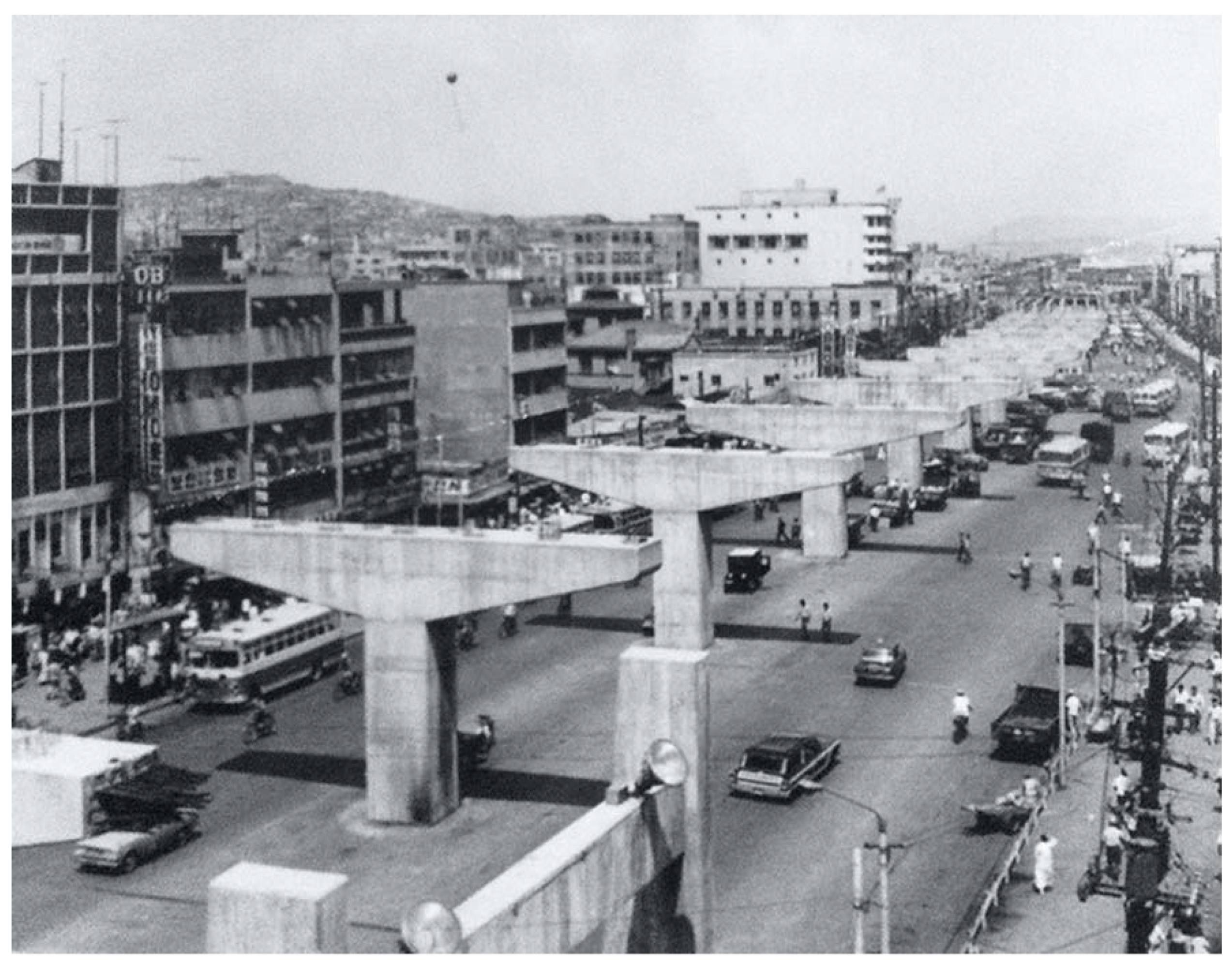
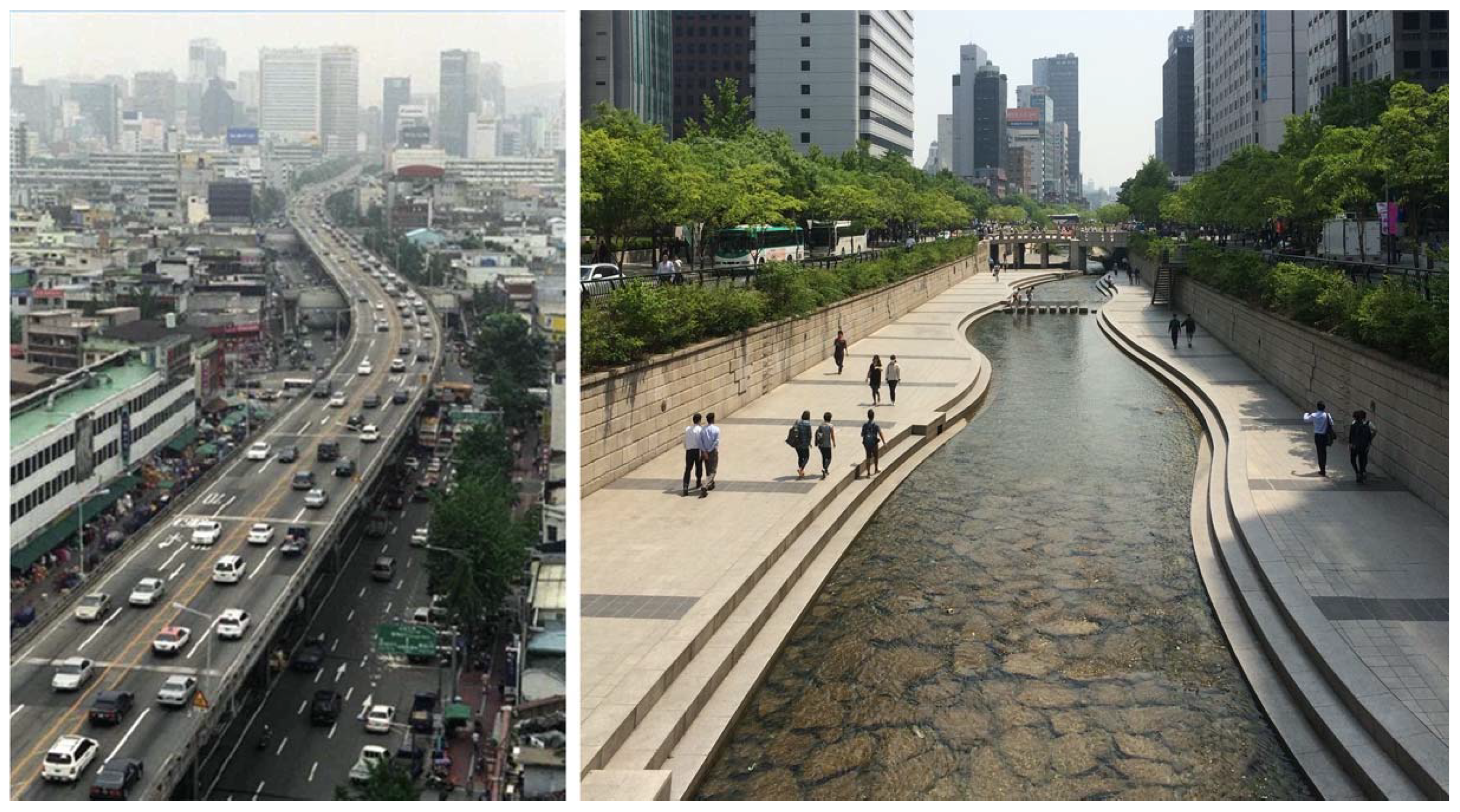
The presence of the Cheong Gye Cheon distinguished the urban landscape of Seoul since its origins. With the process of urbanization of the city that followed the Korean War, along the canal arose a linear slum that would soon become an unhealthy and problematic place. At the end of the 1960s, it was decided to bury the watercourse and build an elevated urban highway in its place (Figure 9). However, as soon as this fast road was inaugurated, a busy and lively market was set up below the viaduct, testifying to the vitality of this area of the city.
Today the role of extraordinary newness of this intervention vis-à-vis the past is also visually linked not only to its ancient history, but also to the paradigm shift marked by the replacement of the urban highway (Figure 10). The elevated road is one of the strongest symbolic images of modernity and the progress of industrial society, as well testified by the cover image of Giedion’s Space, Time and Architecture [43]. The two images of the Cheong Gye Cheon before and after the intervention summarize the transition from a city that has rapidly modernized to a metropolis that looks to the future with balance and optimism. The 5.8 km of the canal, from the center of Seoul to the confluence with the Han river, also represented an instrument of public consent by the political promoter of the operation. At the time, Seoul mayor Myung Bak Lee was photographed several times on the site during the demolition, the reclamation, and finally—beaming—at the inauguration of the canal. He would later use the notoriety acquired with this landmark operation to win South Korea’s presidential elections in 2007 and remaining in office until 2013. During the two days of the opening ceremony, about two million people visited the site. This success gives a measure of the significance of the canal, which certainly goes beyond the environmental, ecological, or functional aspects of pedestrianization of an important part of the city center (Figure 11) [44]. It is the symbolic aspect that constitutes the real added value, together with the chain reaction triggered by the recovery of the canal in the urban development of the city. The inauguration of the Cheong Gye Cheon was the turning point in the city’s planning strategy: these were no longer focused on exclusively technical–functional decisions and short-term development, but with a long-term vision, based on the well-being of the inhabitants (Figure 12), public health, environmental sustainability, and the role of landscape as the main tool for building the historical–cultural identity, not only of the city, but of the entire nation.
4. The Water Landscape between Program and Context: The Case of Candlestick Point Cultural Park in San Francisco
The Candlestick Point Cultural Park project began in late 1985, when the Office of the State Architect, the Department for Parks and Recreation, and the California Arts Council commissioned landscape studio Hargreaves Associates, architectural firm Mack Architects, and artist Doug Hollis to redesign the area of an abandoned landfill located along San Francisco City Bay (Figure 13).
Studio Hargreaves is interested in the construction of new landscapes in areas strongly marked by man-made changes in the ecosystem. Its design approach refers to the current landscape urbanism when it assigns the landscape a central role in the processes and projects of transformation of cities. The historical evolution of landscape urbanism is well represented by the text Landscape Urbanism: A North American Perspective by Alissa North and Charles Waldheim [45].
This project, which was completed in the mid-Nineties, suggests many themes of reflection, making its analysis extremely topical. The first area of interest is related to the choice of the people in charge of the project: a decision that reveals the willingness of the promoters of the intervention to experiment, in an institutional way, an innovative approach for the landscape project. The working group, strongly multidisciplinary was, first of all, asked to govern a participatory process involving several actors from the local community, as well as the Corps of Engineers, the Bay Conservation Development Commission, and the Water Control Board. The main goal of this processual strategy was to encourage the construction, through the redesign of this scenario, of a new relationship between nature and artifice that would be declined far beyond the contemplative dimension (Figure 14).
4.1. Nature and Landscape Design
The natural elements are used as real tools of the project: soil, water, and air are the components that define the language adopted for the landscape design, establishing the formal foundations. The project interprets a modern principle of resilience through the use of original ways of interpreting the ecological perspective.
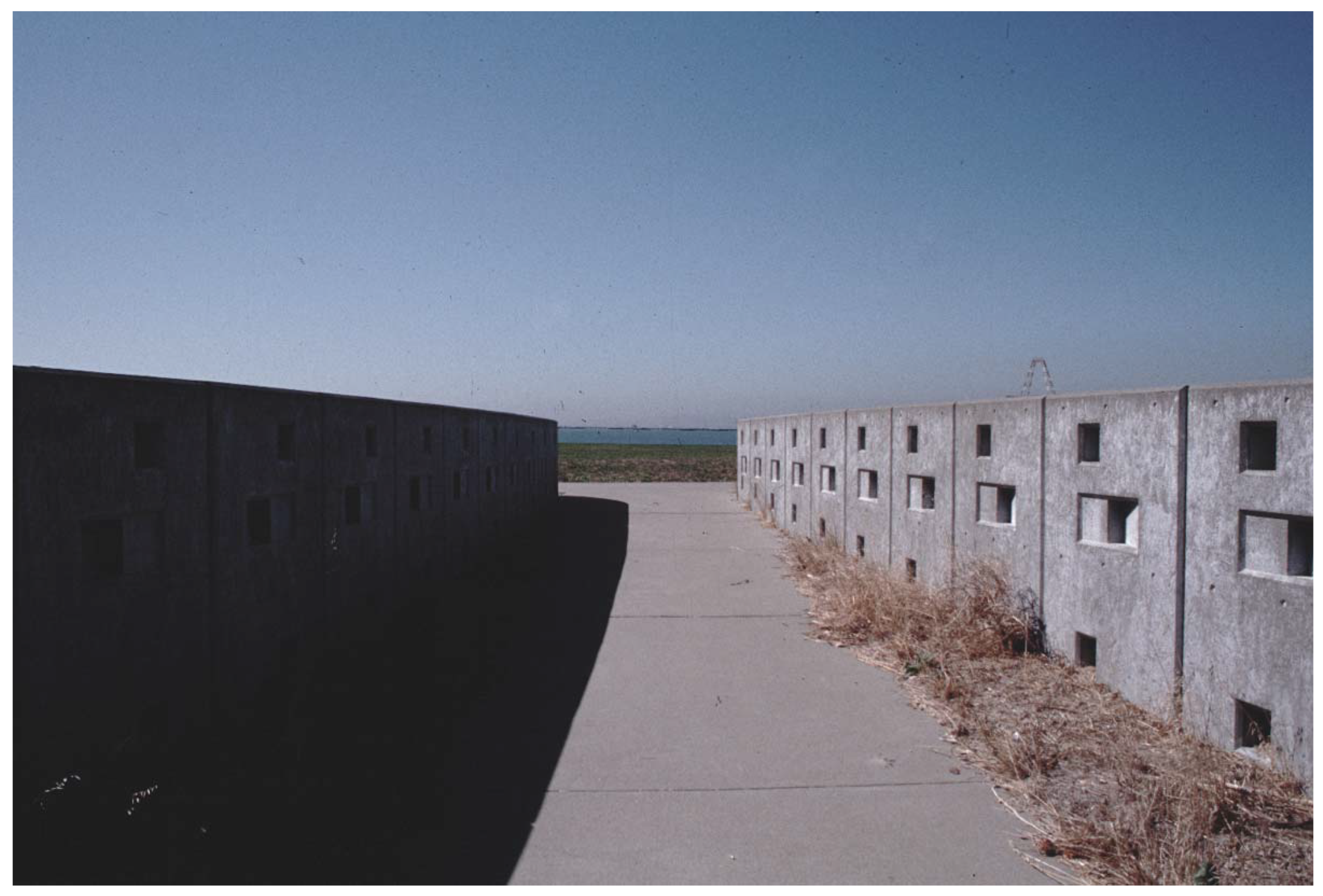
Air is the protagonist of the entrance to the park, the so-called “wind gate” organized through a tunnel positioned along the dominant axis of the main winds: the act of entering unfolds as a real sensory experience. The visitor feels on his body the very breath of the wind, a characteristic element of this stretch of the bay of San Francisco, amplified by the very design of the walls that progressively lead him towards the narrow opening marking the entrance to the park (Figure 15).
The wind also determines the artificial redefinition of the morphology of the sequence of dunes—designed for leisure, play, or picnics—which are offered to the eye of the visitor as soon as he enters the park. One of them wraps around a two-floor pylon hiding a theater. To better understand the meaning and significance of the basic invention behind the project, we can present an excerpt from a text by the landscape design studio, extracted from the book The Alchemy of Landscape Architecture:
Arriving on the site, the design team would park at the edge and walk to the water with a strong wind at their backs. After many visits, this experience developed into an idea to intensify the effect of this phenomenological sequence on the wind carrying the visitor to the water. The designers created a wind gate at the entry point.[46]
However, despite the strong figurative inspiration, the project does not fail to anticipate the theme of the ecological relationships of the soils of the marine margin, where, between the rising of levels, penetration of the salt wedge, and changes in plant and soil systems, there is a complex interaction between uncontrollable elements—winds and tides—and forms with which the project conforms.
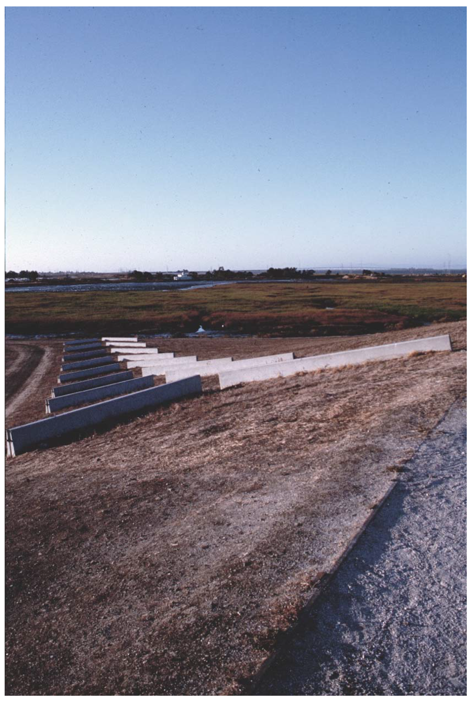
The theme of critical soil remodeling through the use of waste materials is recurrent in Hargreaves’s landscape action. As an example, we could cite the work for the Byxbee Park in Palo Alto, equally aimed at the recovery of a landfill and elaborated with the artists Peter Richards and Michael Oppenheimer. In this intervention, the artificial embankments are nothing more than turf-covered piles of waste from which to observe the park, functional to the triggering of cognitive and reflective processes (Figure 16). The realization of artificial dunes also occurs in the most recent project of the Tejo and Trancão Park, in Lisbon, developed by Hargreaves together with João Nunes, where they are in the form of huge “scratches” in the ground.
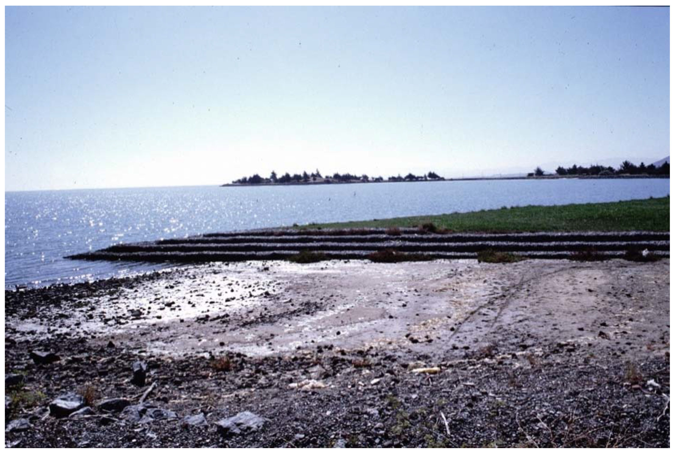
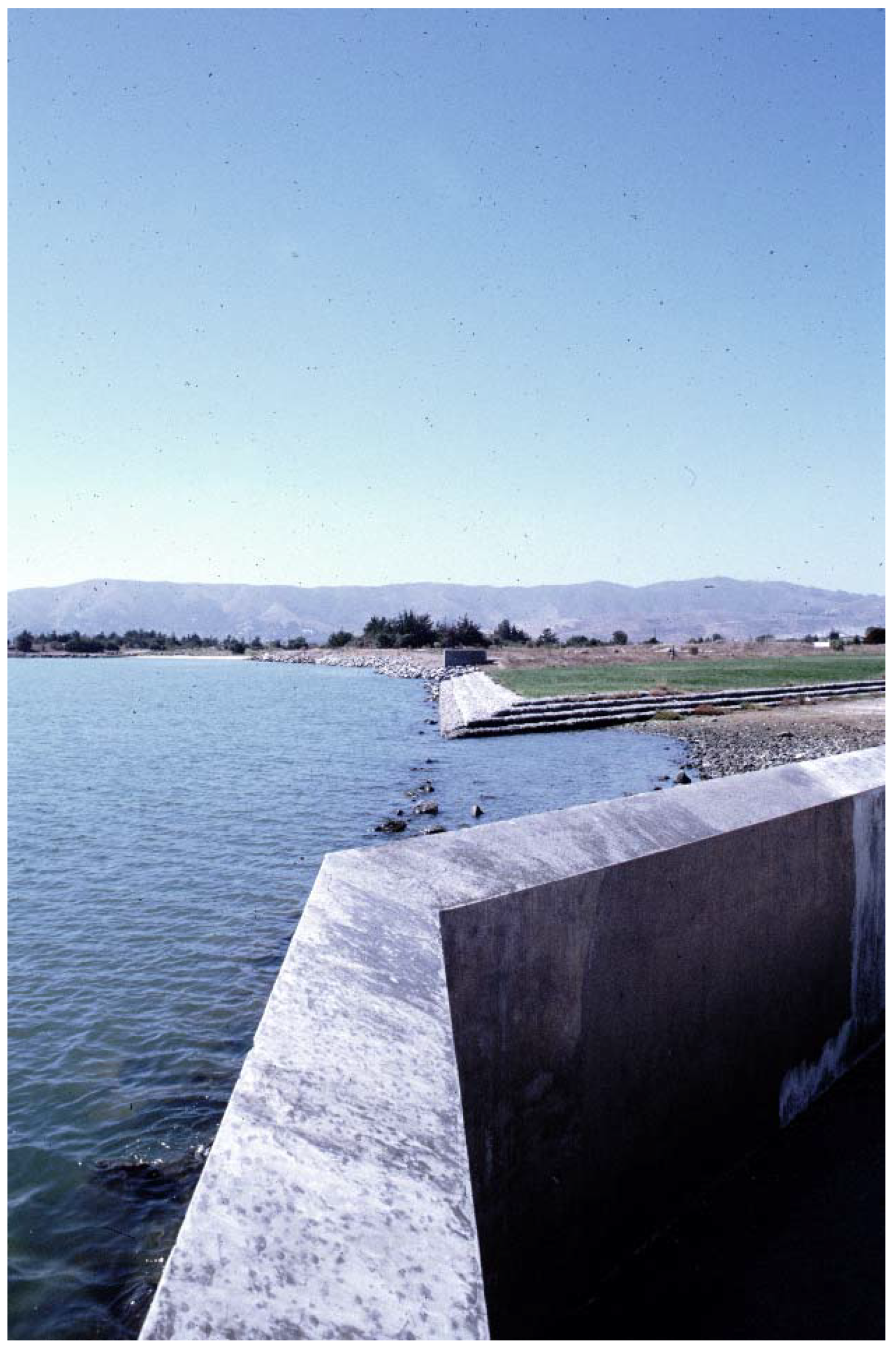
The reference to conceptual art and the recovery of memory are two further elements linking the experience of the park’s projects of Candlestick and Byxbee, thanks to the contribution of the artists participating in the two working groups [47]. In the specific case of Candlestick Park, the intervention by Douglas Hollis takes the form of a large natural sloping surface, located shortly after the entrance to the park, bordered by canals that collect seawater when the level rises (Figure 17).
Along the same channels, once the action of the tide that shapes the site’s form is completed, the debris from the sea are left when it recedes. An action that allows us to bring the experience of the beach and the marshes—very frequent in this area—closer to the city, entering the park under the form of the concrete path that starts just outside the access passage (Figure 18).
The synergy that this experience proposes with the action of the artists is rooted in the solid U.S. tradition that sees in the Earthworks series [48] or in some land artworks, such as Robert Smithson’s Spiral Jetty, the most well-known references. Landscape design, therefore, becomes an opportunity to communicate an ecological message on the issue of recycling and the preservation of the natural environment that this landscaping project places among its main ambitions, inviting us to read environmental waste as an opportunity rather than a wound.
The actions carried out highlight the dual relationship that the intervention establishes with the time factor. On one hand, it refers to the history of the site as a design element; on the other, it considers the environment of the park as a space that does not offer itself through an a priori form, but rather through an open form modeled by time and, as such, facilitating the active involvement of the user. Entrusting the aestheticizing dimension of a landscape to the procedural components of the natural elements, and emphasizing its potential performative character, leads to the emergence of a true environmental theater. The user is the protagonist of the scene; air, water, and wind are the tools through which he can compose the images produced by the flora and fauna found on the site. Hargreaves studio has effectively implemented this strategy also during the complex experience of the Guadalupe River Park.
The remodeling of the soil of this natural environment is resolved in a figurative dimension that responds to the goal of promoting flood control through the creation of a facility at the service of the city, where people and wildlife find a peaceful coexistence [1]. The contemporaneity of the landscape project is achieved through the process put in place by the natural elements, as underlined by the words of the authors:
The design team sought to open the park to the environmental processes of the Bay, setting in motion an overall form of the park that would change over time. […] The design uses native plant communities to occupy the space, left to thrive where the condition allows it. At Candlestick Park, the designed interactions with environmental processes create a large scale phenomenological landscape that emphasizes the individual experience in a composed yet open-ended landscape.[46]
4.2. A Changing Scenario
It is now possible to return to the theme of resilience as the ability of a designed landscape to react to profound future transformations. The site of the park was created to redesign an open reservoir adjacent to the sea and solely marked by the presence of the stadium. This building, once the home to the famous football team of the San Francisco 49ers, was eventually demolished, and the area is now undergoing a colossal real estate redevelopment.
The project is an impressive conversion process that is configuring the park area as a green filter between the sea and a new neighborhood, resulting from the substantial investment of seven billion dollars. It has introduced a new condition requiring the park itself to express its potential in the face of such a drastic physical change, a condition in which natural elements such as water, air, and soil are called, in different forms, to continue to interact with time, the most expressive “material” that the project has called into play.
5. Final Remarks and Perspectives
Soil is a precious and non-renewable resource that affects the relationship between man and the ground. As a system that produces ecosystem services, the soil is crucial for survival (food, water, carbon storage) and quality of life in contemporary habitats.
Particularly in conditions of strong urbanity, this resource is rare and must be used in the most conscious and forward-looking way. To maintain soil functionality and increase the production of ecosystem services, cities must increasingly move towards models of sustainability and resilience. The 2030 Agenda for Sustainable Development [49], signed in 2015 by UN member countries, in Objective 11 (“Making cities and human settlements inclusive, safe, durable, and sustainable”) sets specific objectives in this regard. The impetuous growth of cities—now inhabited by half the world’s population, a percentage that will reach 60% in 2030—requires a model of urbanization minimizing the environmental impact of cities, not only in terms of air quality and waste management, but even more through management and planning of land use, marking a clear break from previous models.
In this perspective, water—between scarcity and excess—is a very delicate and immediately tangible issue of the need to consider the planet in its global context, without administrative or national boundaries. At the same time, in landscape design water represents a resource in functional terms of risk management, increasing biodiversity, temperature, and humidity control. The same concept of “hydraulic invariance”, which will hopefully soon be an essential part of the debate on urban regeneration, directly involves water relationships [50].
The three case studies represent ideas on the relationships between natural elements that decline an articulated range of impacts in terms of ecosystem services. Similarly, in their specificity, they can be considered important points of reference for the subsequent developments of the discipline: three turning points for very different cities, located in three different continents which, however, touch on a theme so general, to be observed in its common repercussions and—we could say—in its planetary relevance [51].
In terms of results, these must therefore be considered more for their intangible results: their ability to produce new project directions and disciplinary reflection and for their social success.
The case of San Francisco is oriented towards a complex of relapses close to the social categories of ecosystem services. “Opening a way” means choosing an adaptive path instead of a fixed model contrasting with certain natural phenomena, and Hargreaves Associates’ project embraces an open, flexible, multi-scalar, and therefore resilient, strategy. This establishes a strong link between the formal figure and the environmental character of the landscape project. The theme of the adaptability and mobility of the natural elements developed in this project, between hydraulic engineering, coastal ecology, and landscape form, represents the basis of a system of studies and projects that have reached today through case studies such as numerous research project for the Mississippi Delta or more recent works by Brian Davis on the geomorphological dimension of the coasts.
In the case of the recovery of the Cheong Gye Cheon canal in Seoul, the category of ecosystem services most concerned is the one related to cultural values. Although apparently the project of this green infrastructure primarily concerns all environmental and natural functions, it is precisely the aesthetic, educational, and recreational benefits provided by the new ecosystem that has guaranteed the project of SeoAhn Total Landscape an immediate and lasting success. The idea that through the landscape project public space becomes a structuring element of the new (but rediscovered) urban form of Seoul, certainly constitutes a turning point in the Korean context, but also in other cities, as the quoted project in Madrid, or several new urban waterfronts, as the Brooklyn bridge park in New York by Michael Van Valkenburgh, the Rhone river banks in Lyon by In Situ Architectes Paysagistes, and the River Garonne waterfront in Bordeaux, France by Atelier Corajoud.
The Amsterdam project expresses a double value in terms of production of ecosystem services, where the improvement of the overall ecological quality of the soil and the site is associated with a clearly positive impact in terms of socio-cultural and economic values. This is the evident case where an innovative project of administrative management of an urban problem, associated with an effective choice of landscape-based solutions, finds synergy with explicit effects. Here, as before in Parc du Sausset by Claire and Michel Corajoud and in Duisburg Park by Peter Latz and Partner, or later in Berlin’s Potsdamer Platz by Atelier Dreiseitl, water engineering, however complex, is transformed into a formal quality of a place, publicly representing the choices made to solve an original problem and contributing to the creation of a new shared aesthetic perception.
The three case studies can be considered as the basis of a system of best practices that has several lines of investigation. Europe has further developed these arguments in the urban fabric, reasoning on the good practices of “ecological neighborhoods”, such as the recent interventions of “resilient landscapes” by Agence Ter in Paris for the neighborhoods of Boulogne-Billancourt and Saint-Ouen, or those of Copenhagen and Malmo by Stig L. Andersson. In Asia, many international offices and in particular Turenscape of Kongjian Yu, work on resilience and soil quality as a focus for the sustainability of newly settled megalopolises. In the USA, they work on large environmental systems, like the large public park atop a former landfill Freshkills Park on Staten Island, by James Corner.
For all of the above, the result of these analyzes once again highlights the importance of project work on the relationship between the two elements, in the more general framework of sustainability action. Whether it is the great resilience systems to oppose the effects of climate change, or the urban interventions of soil qualities redevelopment and water recovery and recycling; or whether the reasoning is subverted and dominated by the concern for the absence of water, such as in campaigns against the advancement of deserts, or such in the projects with zero water balance, the role of water–soil systems in contemporary landscape architecture design is an element that today seems difficult to ignore.
These examples also always start from places of waste or degradation. Reading environmental waste as an opportunity rather than a wound is one of the greatest challenges of contemporary design, and the three cases examined, although conceived at the turn of the millennium, already refer to a model of sustainability completely different from a typical 20th-century approach. In this sense, this change of approach can be considered as a result of direction and perspective for the current evolutions of the discipline towards environmental sustainability.
No longer based on impact mitigation operations or technological devices capable of “correcting” the side effects of development, this new way of thinking sustainable development tends not only to imagine solutions to problems but rather to plan human settlements in an inclusive, integrated and participatory way. This may mean recycling waste landscapes, basing regeneration processes on an idea of resilience. The adaptive approach, finally, is based not only on the time factor and the process method, but on holistic risk management, on the widest possible access to public space, and on its performative character, where the user is the protagonist of the scene that he experiences.
Author Contributions
Abstract and introduction: F.D.C., A.G., and L.R.; Cultuurpark Westergasfabriek: F.D.C., Cheong Gye Cheon: L.R.; Candlestick Point Cultural Park: A.G.; Final remarks: F.D.C., A.G., and L.R. All authors have read and agreed to the published version of the manuscript.
Funding
This research was supported with individual research funds from Sapienza.
Conflicts of Interest
The authors declare no conflict of interest.
References
- Steiner, F.R.; Thompson, G.F.; Carbonell, A. Nature and Cities. The Ecological Imperative in Urban. Design and Planning; Lincoln Institute of Land Policy: Cambridge, MA, USA, 2016. [Google Scholar]
- Vlug, J.; Noortman, A.; Aben, R.; Ter Mull, B.; Hendriks, M. The Need for Design. Exploring Dutch Landscape Architecture; Van Hall Larenstein: Leeuwarden, The Netherlands, 2005. [Google Scholar]
- Adriaens, F.; Dubbeling, M.; Feddes, F.; Marcelis, A.; Overveld, C.V.; Struben, H. Sustainable Urban. Design: Perspectives and Examples; Blauwdrok: Wageningen, The Netherlands, 2005. [Google Scholar]
- Holden, R.; Diedrich, L.; Luiten, E. Fieldwork; Birkhaüser: Basilea, Switzerland, 2006. [Google Scholar]
- Izembart, H.; Le Boudec, B. Waterscapes; Gustav Gili: Barcelona, Spain, 2003. [Google Scholar]
- International Biennial of Landscape Architecture, Barcelona. Available online: https://landscape.coac.net/en/previous-editions (accessed on 5 November 2020).
- Landezine. Available online: http://landezine.com (accessed on 5 November 2020).
- Müller, L.; Lanz, K.; Rentsch, R.; Schwarzenbach, R. Who Owns the Water? Lars Müller: Zurich, Switzerland, 2006. [Google Scholar]
- Swyngedouw, E. Urban Water: A Political-Ecology Perspective. Available online: www.jstor.org/stable/23288796 (accessed on 1 November 2020).
- Shannon, K.; De Meulder, B. Water Urbanisms; Sun Architecture: Amsterdam, The Netherlands, 2008. [Google Scholar]
- Kaika, M. City of Flows: Modernity, Nature and the City; Routledge Taylor & Francis Group: London, UK, 2005. [Google Scholar]
- Butler, D.; Davies, J.W. Urban Drainage; Spon Press: New York, NY, USA, 2000. [Google Scholar]
- Ahammed, F. Ahammed, F. A review of water-sensitive urban design technologies and practices for sustainable stormwater management. In Sustainable Water Resources Management; Springer: Berlin, Germany, 2017; Volume 3, pp. 269–282. [Google Scholar]
- Melbourne Water Corporation. Water Sensitive Urban. Design Guidelines; South Eastern Councils; Melbourne Water Corporation: Melbourne, Australia, 2013.
- Matos, S.M. Public Spaces for Water: A Design Notebook; CRC Press: London, UK, 2020. [Google Scholar]
- Orff, K. Toward an Urban. Ecology: SCAPE/Landscape Architecture; Monacelli Press: New York, NY, USA, 2016. [Google Scholar]
- Moore, C.W.; Mitchell, W.J.; Turnbull, W. The Poetics of Gardens; MIT Press: Cambridge, MA, USA, 1988. [Google Scholar]
- Jullien, F. Vivre de Paysage ou L’Impensé de la Raison; Gallimard: Paris, France, 2014. [Google Scholar]
- Kirkwood, N. Manufactured Sites: Rethinking the Post-Industrial Landscape; Taylor & Francis: New York, NY, USA, 2001. [Google Scholar]
- Thompson, I.H. Ecology, Community and Delight: Sources of Values in Landscape Architecture; Taylor & Francis: New York, NY, USA, 1999. [Google Scholar]
- Loures, L.; Panagopoulos, T.; Burley, J.B. Assessing user preferences on post-industrial redevelopment. Environ. Plan. B: Plan. Des. 2015, 43, 871–892. [Google Scholar] [CrossRef]
- Koekebakker, O. Westergasfabriek Culture Park: Transformation of a Former Industrial Site in Amsterdam; NAI Publischers: Rotterdam, The Netherlands, 2004. [Google Scholar]
- Hitters, E.; Richards, G. The Creation and Management of Cultural Clusters. Creativity and Innovation Management; Blackwell Publishers Ltd.: Oxford, UK, 2003. [Google Scholar]
- Meyer, P.B.; Williams, R.H.; Yount, K.R. Contaminated land: Reclamation, Redevelopment, and Reuse in the United States and the European Union; Edward Elgar Publisher: Aldershot, UK, 1996. [Google Scholar]
- EPA International Brownfields Case Study: Westergasfabriek, Amsterdam, Netherlands. 2008. Available online: http://epa.gov/brownfields/partners/westergas.html (accessed on 5 November 2020).
- Richards, G. Cultural Attractions and European Tourism; CABI Publishing: Wallingford, UK, 2001. [Google Scholar]
- Treanor, P. Brownfield Gentrification in Amsterdam. 2003. Available online: http://web.inter.nl.net/users/paul.treanor/gentrification.html (accessed on 5 November 2020).
- Verhagen, E. In EPA, International Brownfields Case Study: Westergasfabriek, Amsterdam, Netherlands. 2008. Available online: http://epa.gov/brownfields/partners/westergas.html (accessed on 5 November 2020).
- Hinshaw, M. Amsterdam opens a new culture park. In Landscape Architecture; American Society of Landscape Architects (ASLA): Washington, DC, USA, 2004; pp. 60–71. [Google Scholar]
- Kadlec, R.H.; Knight, R.L. Treatment Wetlands; Lewis Publishers: Boca Raton, FL, USA, 1996. [Google Scholar]
- Moshiri, G.A. Constructed Wetlands for Water Quality Improvement; Lewis Publishers: Boca Raton, FL, USA, 1993. [Google Scholar]
- Izembart, H.; Le Boudec, B. Waterscapes. El Trataimiento de Aguas Residuales Mediante Sistemas Vegetales—Using Plant Systems to Treat Wastewater; Gustav Gili: Barcellona, Spain, 2003. [Google Scholar]
- Amidon, J. Moving Horizons—The Landscape Architecture of Kathryn Gustavson and Partners; Birkhäuser: Basilea, Switzerland, 2005. [Google Scholar]
- Speck, J. Walkable City Rules: 101 Steps to Making Better Places; Island Press: Washington, DC, USA, 2019. [Google Scholar]
- Lee, J.Y.; Anderson, C.D. The restored Cheonggyecheon and the quality of life in Seoul. J. Urban Technol. 2013, 20, 3–22. [Google Scholar] [CrossRef]
- The Big Dig. Available online: https://www.mass.gov/the-big-dig (accessed on 5 November 2020).
- Depaving Seo-Ahn Total Landscape Cheonggyecheon Canal Restoration. Lotus Int. 2015, 157, 92–95.
- Yoon, H.K. The Culture of Fengshui in Korea: An Exploration of East Asian Geomancy; Lexington Books: Lanham, MD, USA, 2006. [Google Scholar]
- Bengston, D.N.; Yeo-Chang, Y. Seoul’s greenbelt: An experiment in urban containment. In Policies for Managing Urban Growth and Landscape Change: A Key to Conservation in the 21st Century; Bengston, D.N., Ed.; North Central Research Station: St. Paul, MN, USA, 2005; pp. 27–34. [Google Scholar]
- De Matteis, F.; Reale, L. Projects for: Seoul 서울. Designing the Megacity; Aracne Editrice: Rome, Italy, 2019. [Google Scholar]
- Seoul Solution. Available online: https://seoulsolution.kr/sites/default/files/Seoul (accessed on 5 November 2020).
- Perini, K.; Sabbion, P. Urban. Sustainability and River Restoration: Green and Blue Infrastructure; Wiley-Blackwell: Oxford, UK, 2017; pp. 193–195. [Google Scholar]
- Giedion, S. Space, Time and Architecture. The Growth of a New Tradition; MIT Press: Cambridge, MA, USA, 1941. [Google Scholar]
- Rowe, P.G.; Sae-Hoon, K.; Jung, S. A City and Its Stream: An Appraisal of the Cheonggyecheon Restoration Project and Its Environs in Seoul, South Korea; Harvard University Graduate School of Design: Cambridge, MA, USA, 2010. [Google Scholar]
- North, A.; Waldheim, C. Landscape urbanism: A North American perspective. In Resilience in Ecology and Urban. Design Linking Theory and Practice for Sustainable Cities; Pickett, S.T.A., Cadenasso, M.L., McGrath, B., Eds.; Springer: New York, NY, USA, 2013. [Google Scholar]
- Hargreaves, G.; Czerniak, J.; Berrizbeitia, A.; Campbell Kelly, L. Hargreaves: The Alchemy of Landscape Architecture; Thames & Hudson: London, UK, 2009. [Google Scholar]
- Vaccarino, R. Paesaggi rifatti. Lotus Int. 1995, 87, 83–87. [Google Scholar]
- Fiori, B. Rundown, Movie by Bob Fiori with a voiceover of Nancy Holt. 1969. Available online: https://www.youtube.com/watch?v=5AmpyiR6kj8 (accessed on 5 November 2020).
- United Nations, Department of Economic and Social Affairs. Available online: https://sdgs.un.org/goals (accessed on 5 November 2020).
- De Nardo, A. Laminazione delle Piene e Invarianza Idraulica; Clean: Naples, Italy, 2018. [Google Scholar]
- Steiner, F.R. Landscape ecological urbanism: Origins and trajectories. Landsc. Urban Plan. 2011, 100, 333–337. [Google Scholar] [CrossRef]
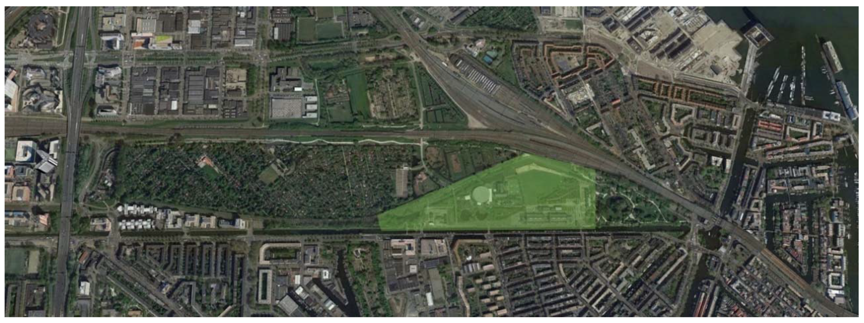
Figure 1.
The Westergasfabrieck Park with the Tuinpark Nut en Genoegen are part of an urban naturalistic strip between Amsterdam and Haarlem, of about 400 × 7.500 m. Aerial view, Google Earth Pro (2020).
Figure 1.
The Westergasfabrieck Park with the Tuinpark Nut en Genoegen are part of an urban naturalistic strip between Amsterdam and Haarlem, of about 400 × 7.500 m. Aerial view, Google Earth Pro (2020).

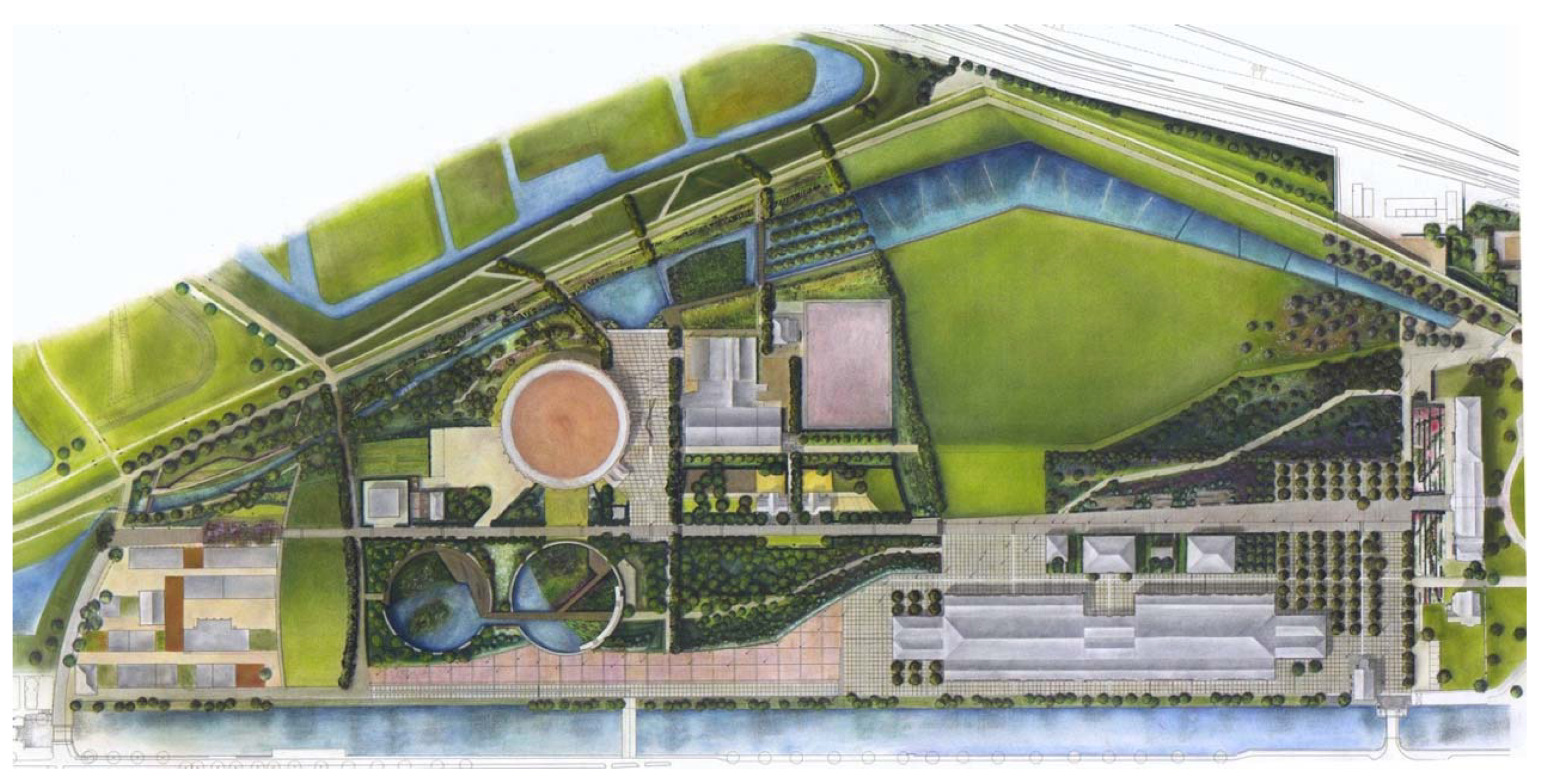
Figure 2.
General masterplan (courtesy by GP&B).

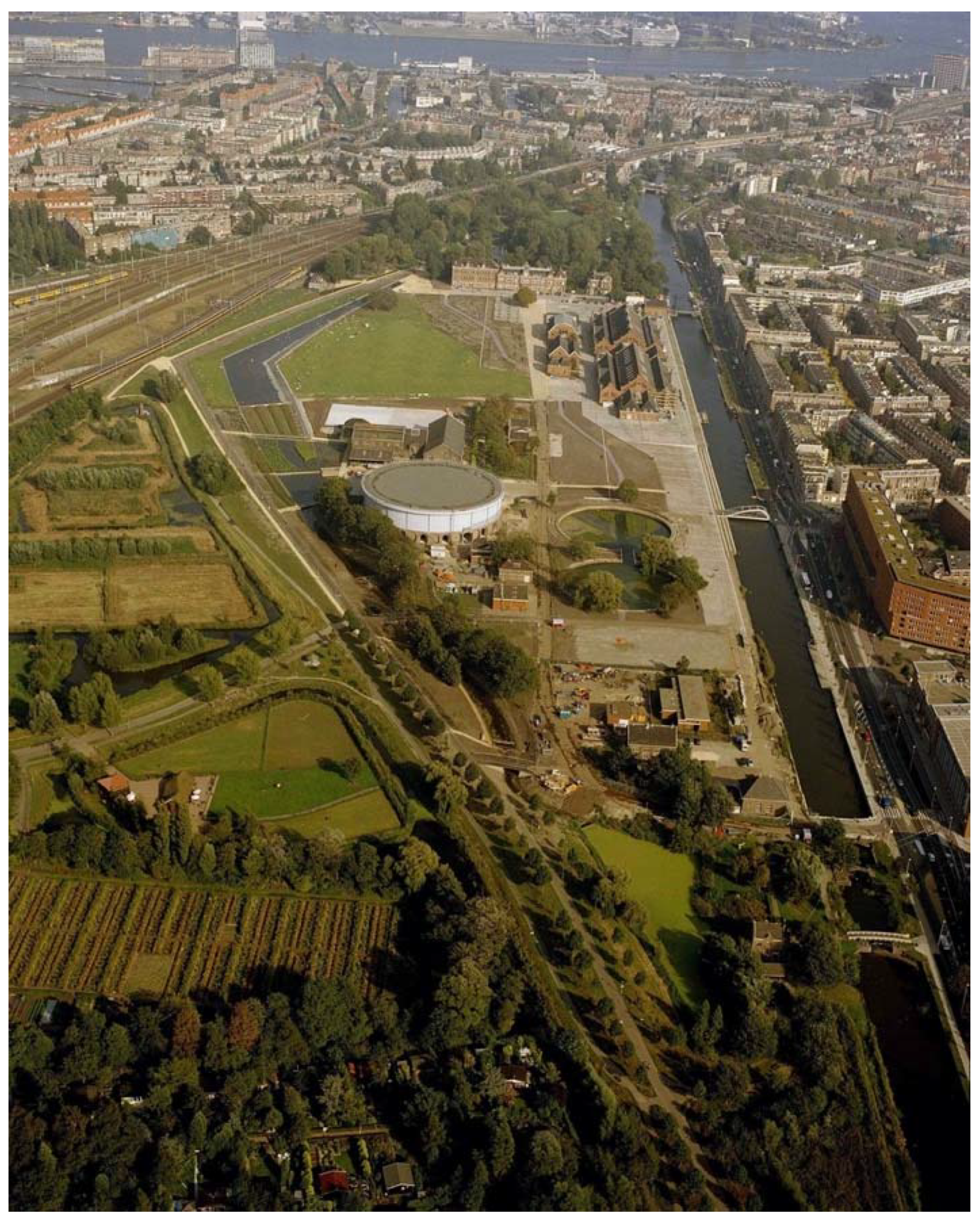
Figure 3.
Aerial view of the park from the West (from GP&B website).

Figure 4.
The “Event Lake” and the main access to the green central areas (from GP&B website).

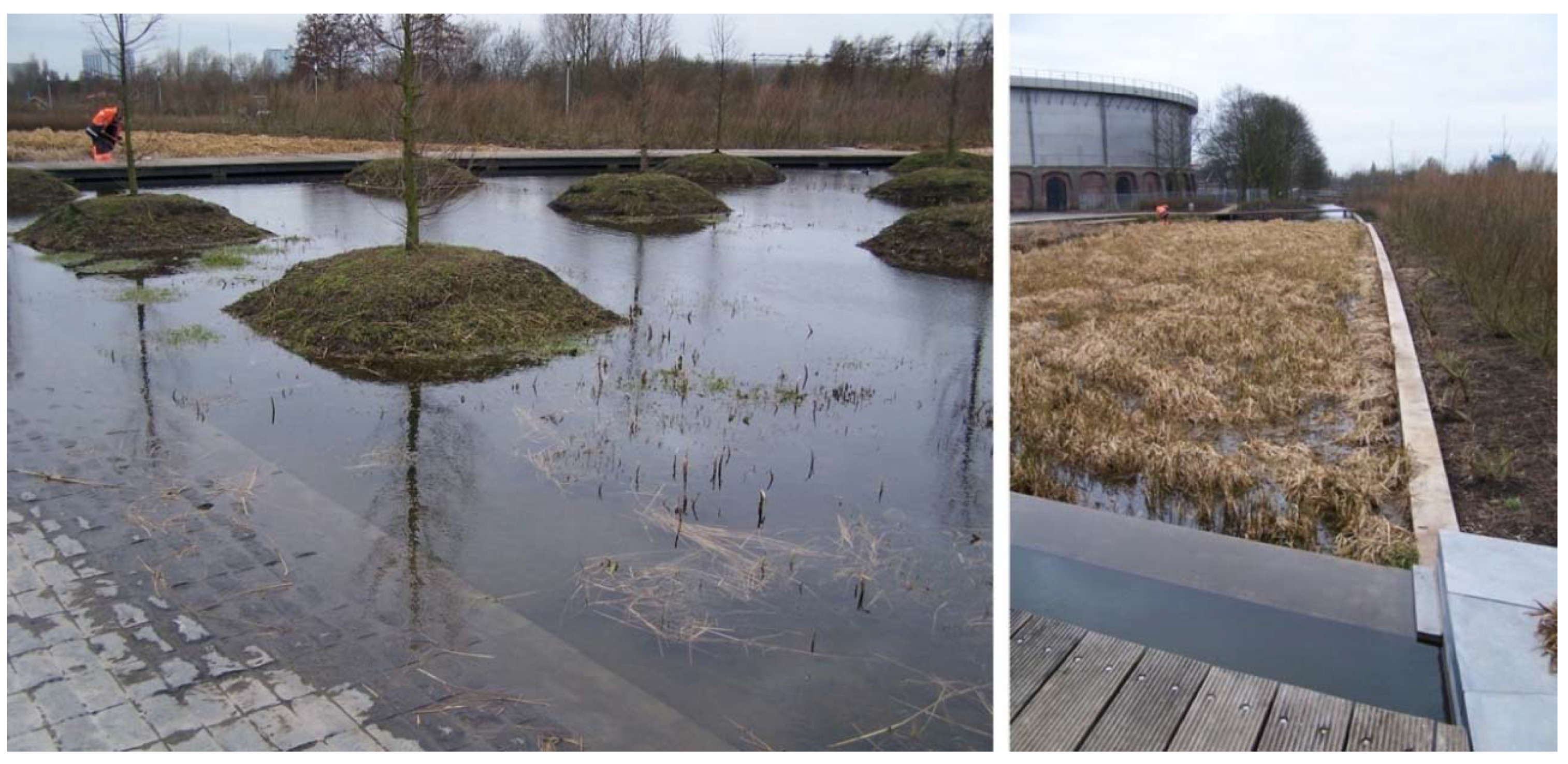
Figure 5.
The formation of the “Wet Gardens”: hygrophilous forest and phyto-purification basins (2009, photo Fabio Di Carlo).
Figure 5.
The formation of the “Wet Gardens”: hygrophilous forest and phyto-purification basins (2009, photo Fabio Di Carlo).

Figure 6.
The development of the “Wet Gardens” has also favored the creation of more intimate spaces (from GP&B website).
Figure 6.
The development of the “Wet Gardens” has also favored the creation of more intimate spaces (from GP&B website).

Figure 7.
Aerial view, Google Earth Pro (2020).

Figure 8.
Seoul city centre: comprehensive map of the Royal Capital (Suseon Yeondo 1861).

Figure 9.
View of the Cheon Gye Cheon Expressway under construction in the early 1960s (Google Images).
Figure 9.
View of the Cheon Gye Cheon Expressway under construction in the early 1960s (Google Images).

Figure 10.
Left: The image of the highway created on the Cheon Gye Cheon’s sediments in the 1960s (Seoul Metropolitan Government). Right: The canal restored and transformed into a linear park in 2005 (photo: Jeremy Khong).
Figure 10.
Left: The image of the highway created on the Cheon Gye Cheon’s sediments in the 1960s (Seoul Metropolitan Government). Right: The canal restored and transformed into a linear park in 2005 (photo: Jeremy Khong).

Figure 11.
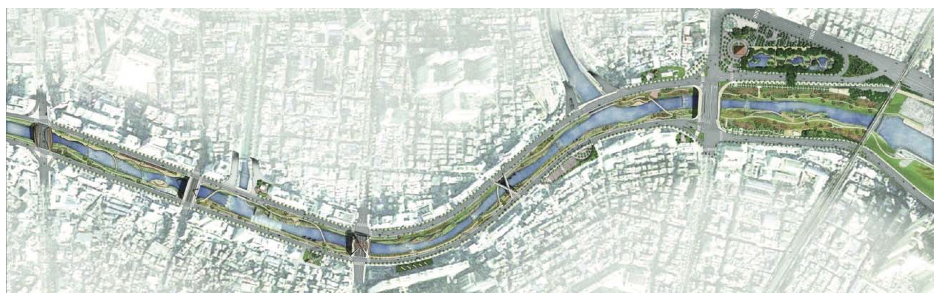
Cheon Gye Cheon’s general site plan (SeoAhn Total Landscape).

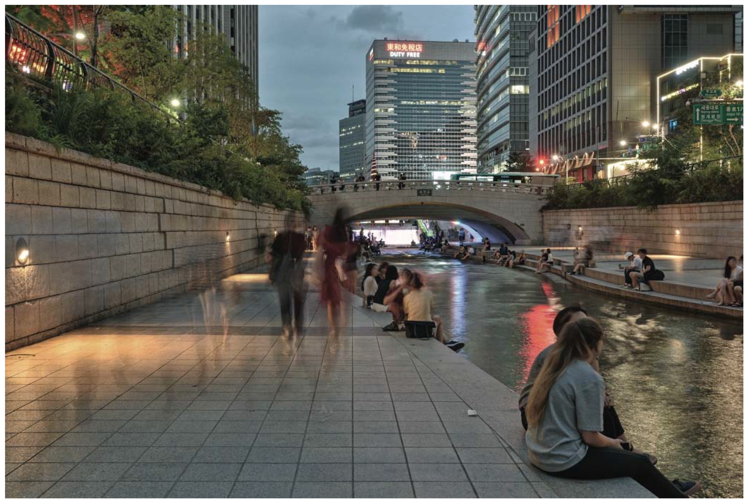
Figure 12.
Social nightlife in summer on the banks of the canal: the Cheon Gye Cheon Plaza, from where the water starts its flow (photo: Ethan Brooke).
Figure 12.
Social nightlife in summer on the banks of the canal: the Cheon Gye Cheon Plaza, from where the water starts its flow (photo: Ethan Brooke).

Figure 13.
Aerial view, Google Earth Pro (2020).

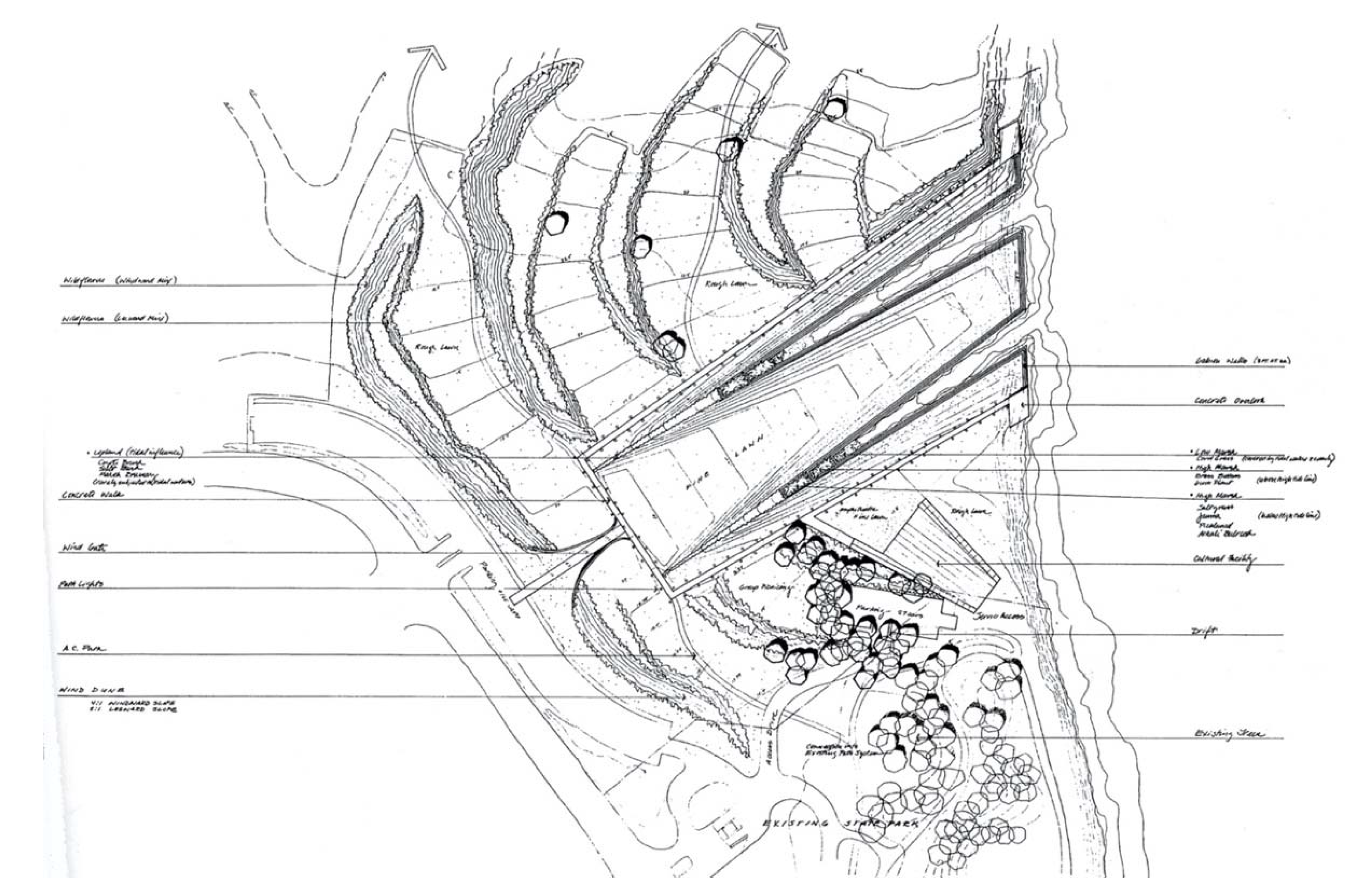
Figure 14.
Candlestick Park masterplan.

Figure 15.
The “wind gate” (photo: Luca Montuori).

Figure 16.
The natural sloping surface (photo: Luca Montuori).

Figure 17.
The natural sloping surface (photo: Luca Montuori).

Figure 18.
Byxbee park (photo: Luca Montuori).

Publisher’s Note: MDPI stays neutral with regard to jurisdictional claims in published maps and institutional affiliations. |
© 2020 by the authors. Licensee MDPI, Basel, Switzerland. This article is an open access article distributed under the terms and conditions of the Creative Commons Attribution (CC BY) license (http://creativecommons.org/licenses/by/4.0/).
Share and Cite
MDPI and ACS Style
Di Carlo, F.; Giancotti, A.; Reale, L. Re-Inventing Water–Ground Relations in Landscape Architecture Projects. Sustainability 2020, 12, 10358. https://0-doi-org.brum.beds.ac.uk/10.3390/su122410358
AMA Style
Di Carlo F, Giancotti A, Reale L. Re-Inventing Water–Ground Relations in Landscape Architecture Projects. Sustainability. 2020; 12(24):10358. https://0-doi-org.brum.beds.ac.uk/10.3390/su122410358
Chicago/Turabian StyleDi Carlo, Fabio, Alfonso Giancotti, and Luca Reale. 2020. "Re-Inventing Water–Ground Relations in Landscape Architecture Projects" Sustainability 12, no. 24: 10358. https://0-doi-org.brum.beds.ac.uk/10.3390/su122410358
Note that from the first issue of 2016, this journal uses article numbers instead of page numbers. See further details here.