A Methodology for Assessing the Implementation Potential for Retrofitted and Multifunctional Urban Green Infrastructure in Public Areas of the Global South


Abstract
:1. Introduction
2. Materials and Methods
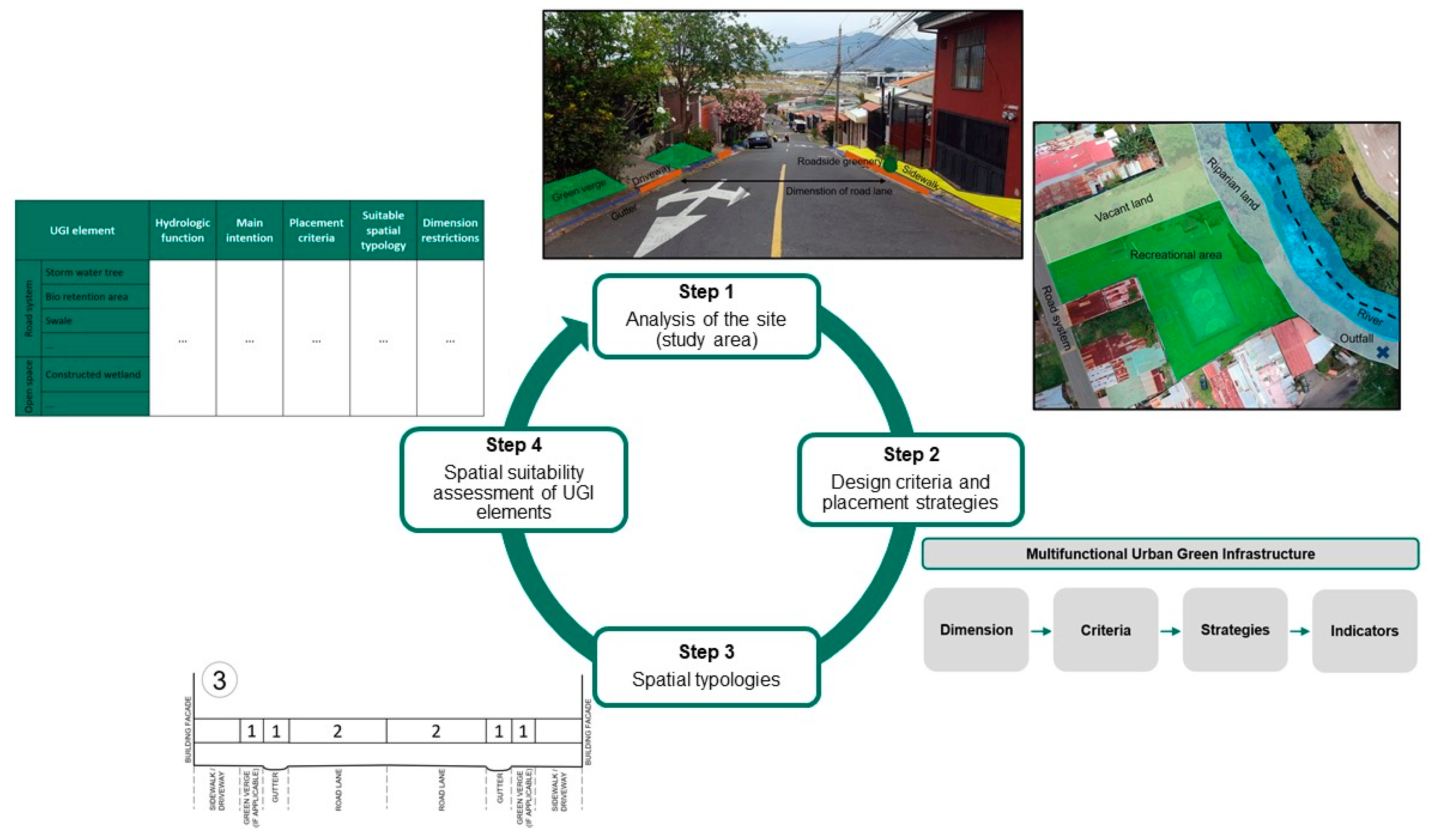
2.1. Methodology to Assess the Placement Potential of Multifunctional Urban Green Infrastructure
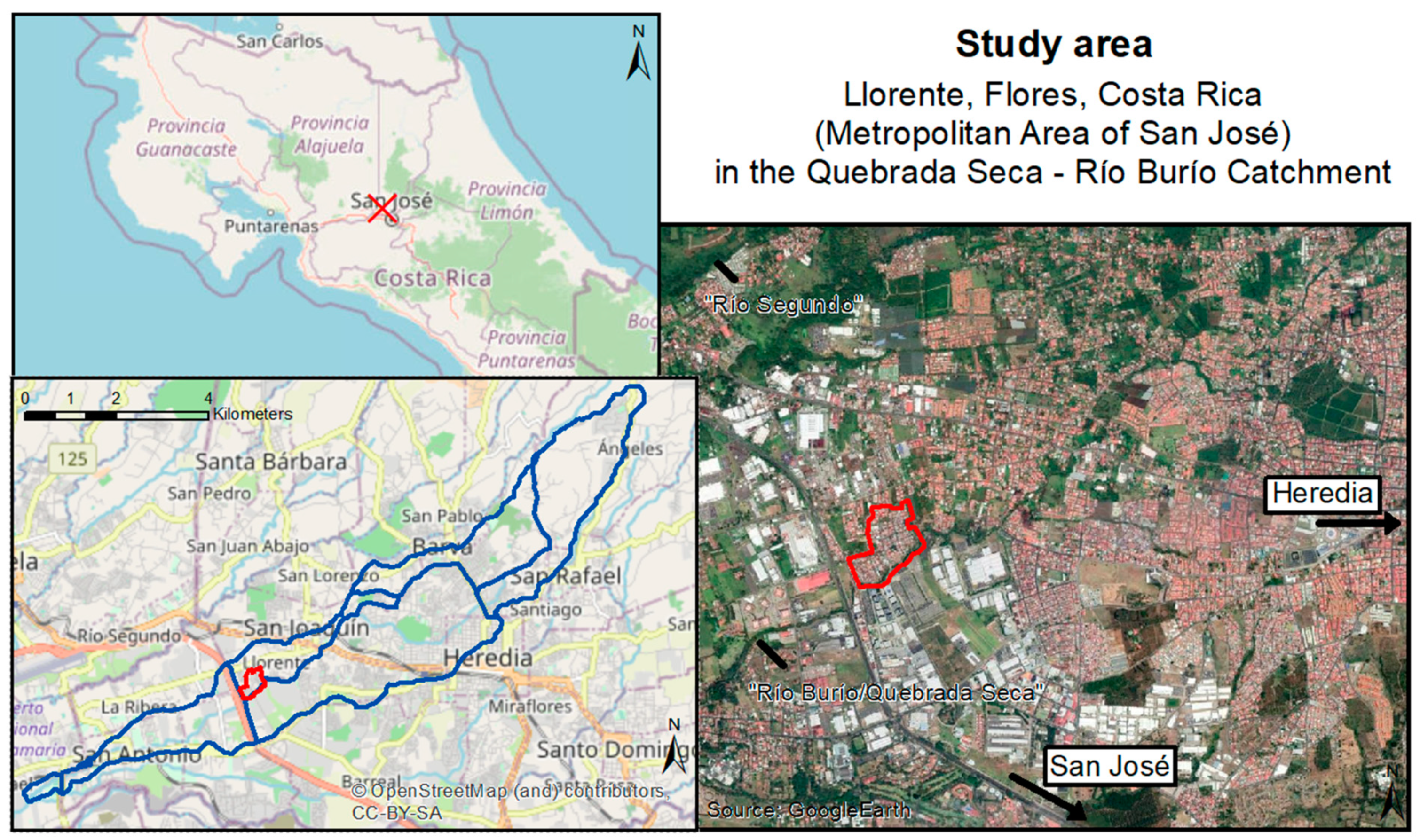
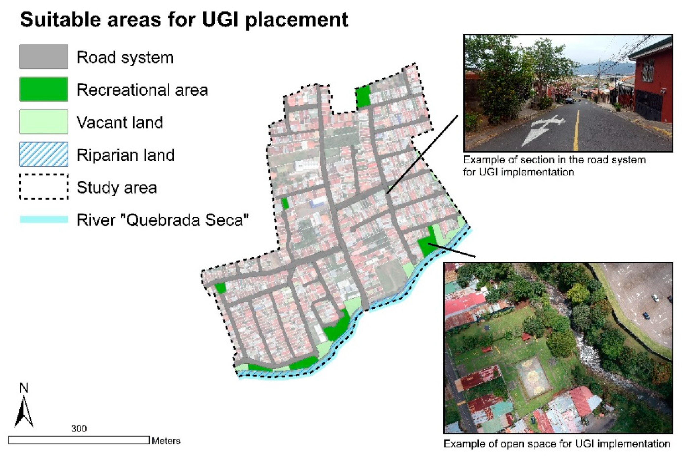
2.1.1. Step 1—Analysis of the Site (Study Area)
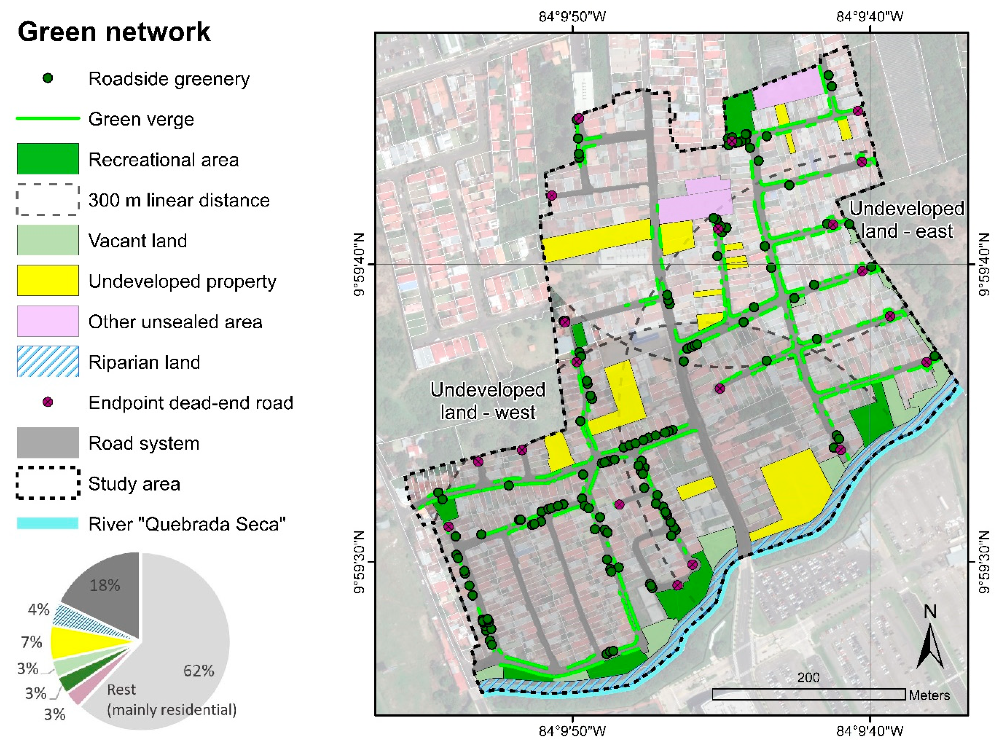
Existing Green Network and Social Accessibility
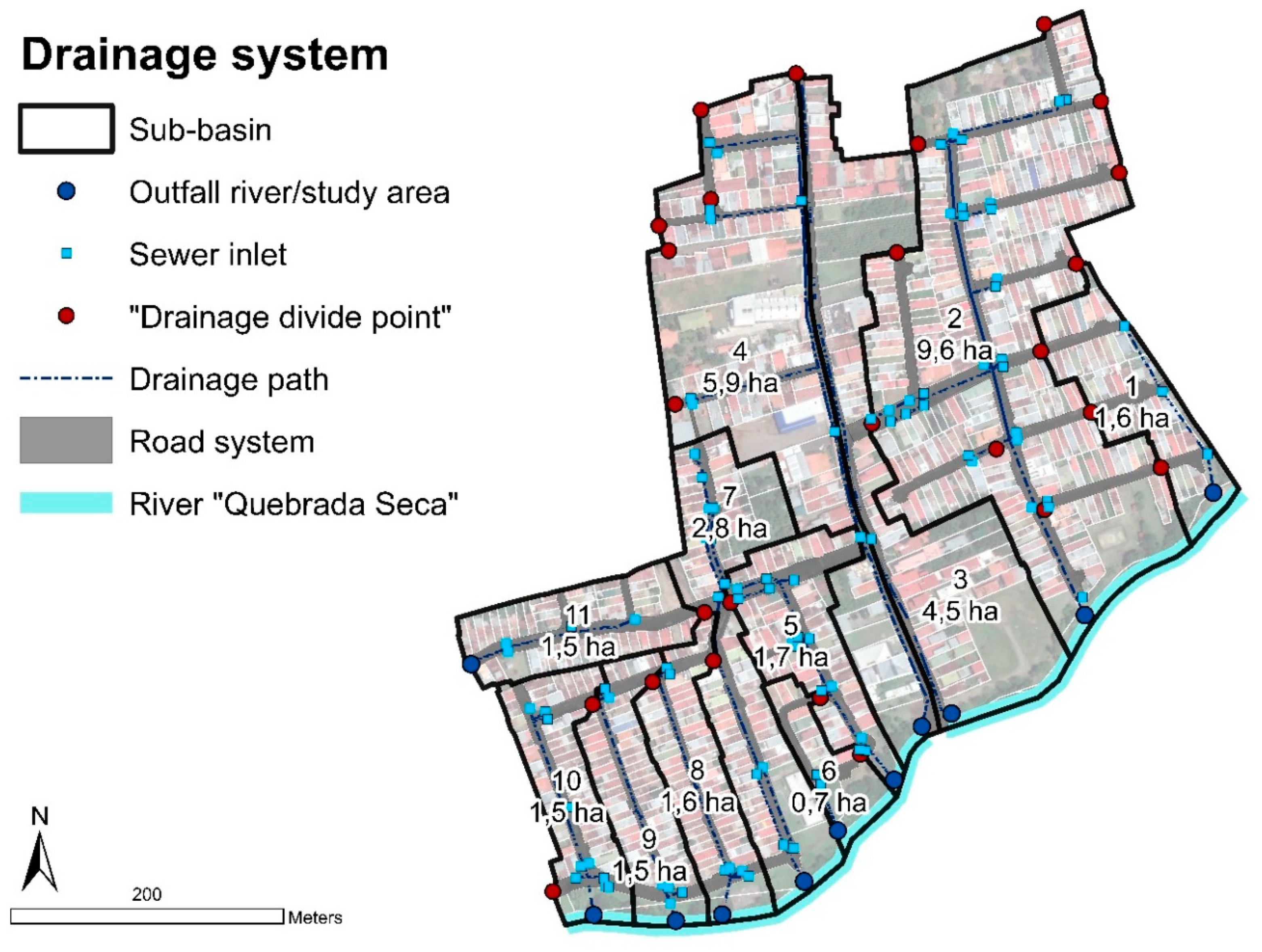
Existing Drainage System
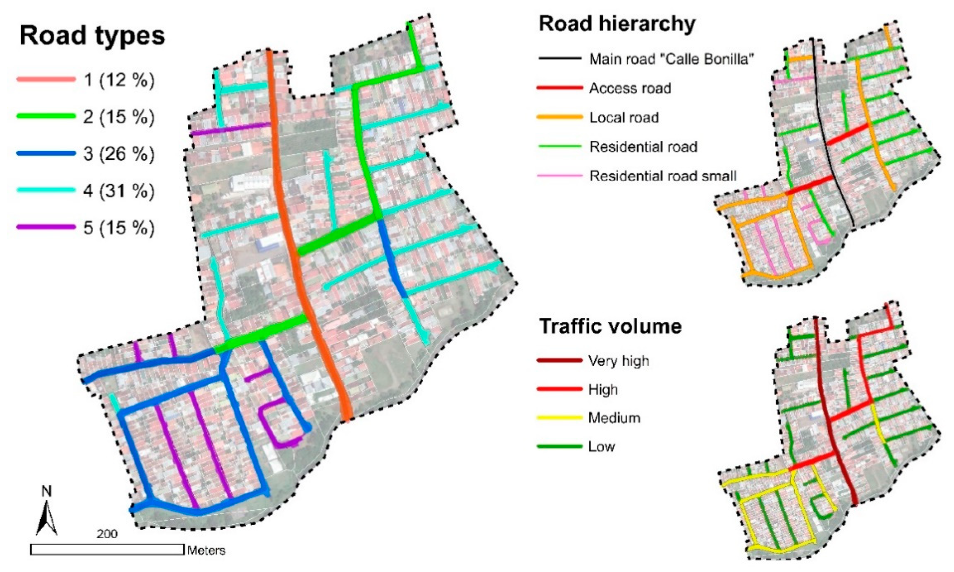
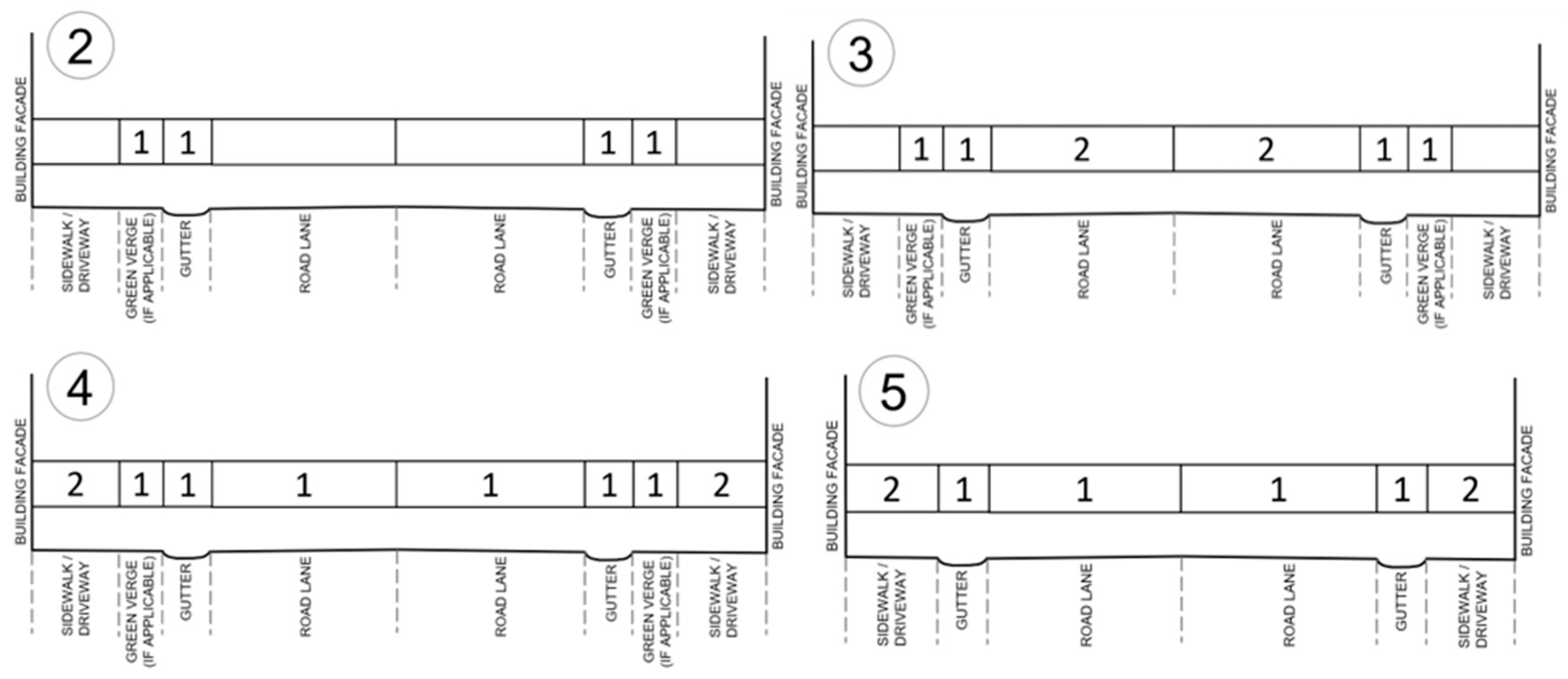
Road Typology and Hierarchy
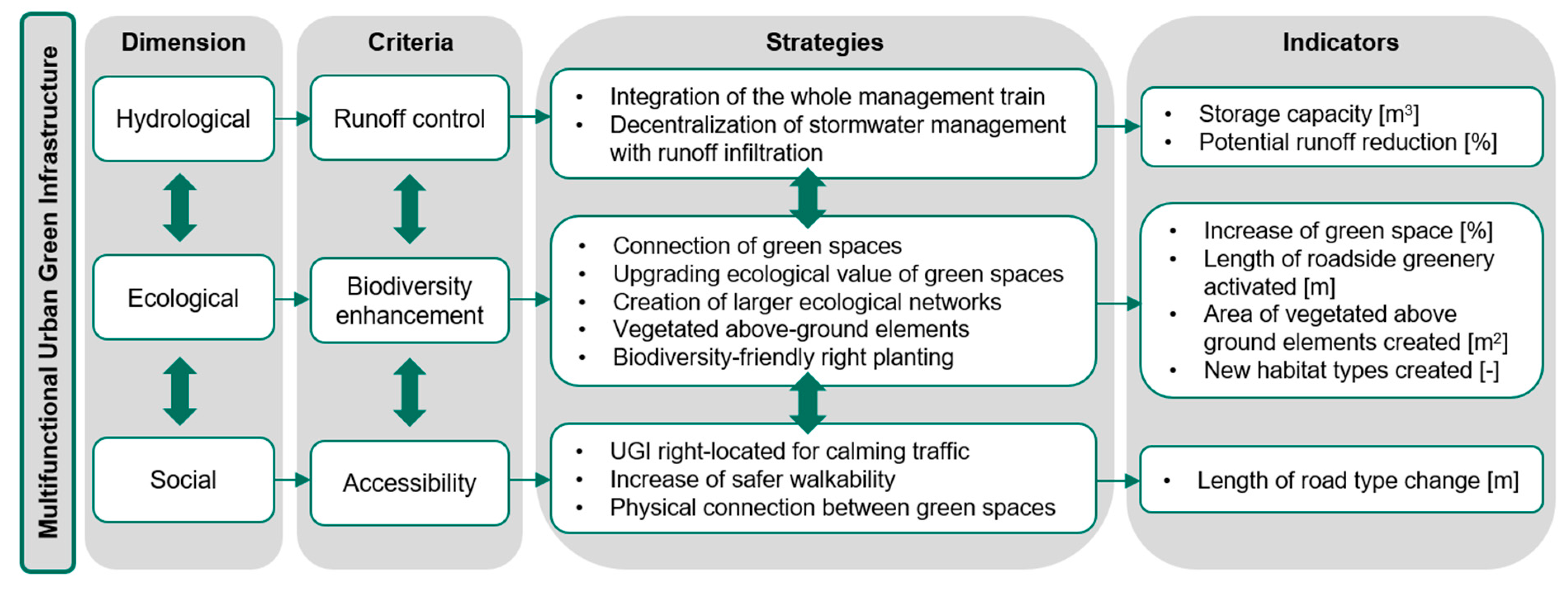
2.1.2. Step 2—Design Criteria and Placement Strategies
2.1.3. Step 3—Spatial Typologies
2.1.4. Step 4—Spatial Suitability Assessment of UGI Elements
3. Results and Discussion
3.1. Multifunctionality—Hydrological Dimension
3.2. Multifunctionality—Ecological Dimension
3.3. Multifunctionality—Social Dimension
3.4. Overall Discussion
3.5. Our Methodology in the Context of Other Recent Studies
4. Conclusions
Author Contributions
Funding
Institutional Review Board Statement
Informed Consent Statement
Data Availability Statement
Acknowledgments
Conflicts of Interest
Appendix A

| UGI Element | Formula | Calculation | Average Storage Capacity |
|---|---|---|---|
| Stormwater tree | Area per element [m2] ∗ ((Depth of system [m]∗ Void volume of filled substrate mixture [%]) + ponding depth [m]) | (1.75 m ∗ 1.75 m) ∗ ((1.0 m ∗ 0.5) + 0.1 m) | 1.8 m3 |
| Bio-retention area | Area per element [m2] ∗ ((Depth of soil [m] ∗ Void volume soil [%]) + (Depth of gravel [m] ∗ Void volume gravel [%]) + depth of ponding [m]) | 30 m2 ∗ ((0.2 m ∗ 0.7) + (0.8 m ∗ 0.4) + 0.1 m) | 16.8 m3 |
| Infiltration trench | Average area per element [m2] ∗ ((Depth of soil layer [m] ∗ Void volume soil [%]) + (Depth of gravel layer [m] ∗ Void volume gravel [%])) | (0.5 m ∗ 27.8 m) ∗ ((0.2 m ∗ 0.7) + (1.0 m ∗ 0.4)) = 7.5 m3 | 7.4 m3 (=0.27 m3 per meter) |
| Detention basin | Available open space [m2] ∗ Average depth of element [m] | 1245 m2 * 1.12 m | 1394 m3 |
| Constructed wetland | Available open space [m2] ∗ Average depth of element [m] | 850 m2 * 1.04 m | 884 m3 |
| UGI Element | Formula | Calculation | Average Drainage Area |
|---|---|---|---|
| Stormwater tree | Average flow length [m] ∗ Average width of drainage area [m] | 7.8 m ∗ 25.5 m | 197.6 m2 |
| Bio-retention area | Average flow length [m] ∗ Average width of drainage area [m] | 46.2 m ∗ 23.5 m | 1085.7 m2 |
| Infiltration trench | Average flow length [m] ∗ Average width of drainage area [m] | 35.5 m ∗ 23.5 m | 834.3 m2 |
| Detention basin | Entire drainage area upstream from placement site | - | 1.6 ha |
| Constructed wetland | Entire drainage area upstream from placement site = Sub-basin area | - | 9.6 ha |
| UGI Element | Hydrologic Functions | Main Intention | Placement Criteria | Suitable Spatial Typology | Dimension Restrictions | |
|---|---|---|---|---|---|---|
| Road system | Permeable pavement | Source control Conveyance control Filtration, infiltration | Multi-use in dense areas Stormwater infiltration | Low traffic volume | Road types 4 and 5 | none |
| Stormwater tree | Source control Retention Filtration | Development of roadside greenery network Buffer to road traffic | Buildings: Min. 2 m distance [36] Green verges: Must be given Driveways: Street sections excluded and min. 2 m distance [36] Intersection/corner: Min. 3 m distance [36] Roadside greenery: 6 m distance in between [36] | Road types 2, 3, and 4 | Length: 1.75 m Width: 1.75 m Depth: 1 m (+0.1 m ponding) | |
| Bio-retention area | Conveyance control Retention Filtration | Vegetated UGI in road system Traffic-regulating element | Green verges: Min. 10 m length Driveways: Street sections excluded Sewer inlet or drainage path: Proximity Flow length: Max. 100 m | Road types 3 and 4 | Length: max. 10 m Width: 3 m Depth: 1 m (+0.1 m ponding) | |
| Swale | Conveyance control Retention Filtration Infiltration | Vegetated UGI in road system | Slope: 0, 5–6% recommended [27,30] Green verges: Min. 5 m length Drainage area: Max. 2 ha recommended [30] Roadside greenery: Difficult to integrate Greywater outlets: Street sections excluded Driveways: Street sections excluded | Road types 3 and 4 | Length: min. 5 m Width: 2.5 m Depth: 0.5 m | |
| Infiltration trench | Conveyance control Infiltration | Vegetated UGI in road system | Green verges: Min. 10 m length | Road types 2 and 3 | Length: min. 10 m Width: 0.5 m Depth: 1.2 m | |
| Open space | Detention basin | Detention Conveyance control/end control | UGI effective for larger events UGI with high potential ecological value Green space enhancement and conversion | Size of drainage area: Max. 2 ha [30] Size of open space: Min. 1/8 of drainage area | Recreational area Vacant land | Depending on the design goal and available space |
| Constructed wetland/ Retention basin | Retention Filtration Infiltration End control | UGI effective for larger events UGI with high potential ecological value Green space enhancement and conversion | Size of drainage area: Min. 5 ha [36] Available open space: Next to outlet river | Riparian land Vacant land | Depending on the design goal and available space | |
References
- European Commission. Towards an EU Research and Innovation Policy Agenda for Nature-Based Solutions and Renaturing Cities. Final Report of the Horizon 2020 Expert Group on Nature-Based Solutions and Re-Naturing Cities; European Commission: Brussels, Belgium, 2015. [Google Scholar]
- Faivre, N.; Fritz, M.; Freitas, T.; de Boissezon, B.; Vandewoestijne, S. Nature-Based Solutions in the EU: Innovating with nature to address social, economic and environmental challenges. Environ. Res. 2017, 159, 509–518. [Google Scholar] [CrossRef] [PubMed]
- Naturvation Naturvation—Cities-Nature-Innovation. Available online: https://naturvation.eu/about (accessed on 23 April 2020).
- EPA. What is Green Infrastructure? Available online: https://www.epa.gov/green-infrastructure/what-green-infrastructure (accessed on 23 April 2020).
- BMT WBM Pty Ltd. Evaluating Options for Water Sensitive Urban Design; BMT WBM Pty Ltd.: Canberra, Australia, 2009. [Google Scholar]
- WWAP/UN-WATER. The United Nations World Water Development Report 2017: Wastewater: The Untapped Resource; WWAP/UN-WATER: Paris, France, 2018. [Google Scholar]
- Díazo, S.; Settele, J.; Brondízio, E.; Ngo, H.T.; Guèze, M.; Agard, J.; Arneth, A.; Balvanera, P.; Brauman, K.; Butchart, S.; et al. Summary for Policymakers of the Global Assessment Report on Biodiversity and Ecosystem Services; Intergovernmental Science-Policy Platform on Biodiversity and Ecosystem Services (IPBES): Paris, France, 2019. [Google Scholar]
- WWAP/UN-WATER. The United Nations World Water Development Report 2018 Report: Nature-Based Solutions for Water; WWAP/UN-WATER: Paris, France, 2018. [Google Scholar]
- Meerow, S. The politics of multifunctional green infrastructure planning in New York City. Cities 2020, 100, 102621. [Google Scholar] [CrossRef]
- Hansen, R.; Olafsson, A.S.; van der Jagt, A.P.N.; Rall, E.; Pauleit, S. Planning multifunctional green infrastructure for compact cities: What is the state of practice? Ecol. Indic. 2019, 96, 99–110. [Google Scholar] [CrossRef]
- Davies, C.; Hansen, R.; Rall, E.; Pauleit, S.; Lafortezza, R.; De Bellis, Y.; Santos, A.; Tosics, I. Green Infrastructure Planning and Implementation; GREEN SURGE: Berlin, Germany, 2015. [Google Scholar]
- Aram, F.; Solgi, E.; Holden, G. The role of green spaces in increasing social interactions in neighborhoods with periodic markets. Habitat Int. 2019, 84, 24–32. [Google Scholar] [CrossRef]
- Golden, H.E.; Hoghooghi, N. Green infrastructure and its catchment-scale effects: An emerging science. Wiley Interdiscip. Rev. Water 2018, 5, e1254. [Google Scholar] [CrossRef] [Green Version]
- Buijs, A.E.; Mattijssen, T.J.; Van der Jagt, A.P.; Ambrose-Oji, B.; Andersson, E.; Elands, B.H.; Steen Møller, M. Active citizenship for urban green infrastructure: Fostering the diversity and dynamics of citizen contributions through mosaic governance. Curr. Opin. Environ. Sustain. 2016, 22, 1–6. [Google Scholar] [CrossRef]
- Singh, A.; Sarma, A.K.; Hack, J. Cost-Effective Optimization of Nature-Based Solutions for Reducing Urban Floods Considering Limited Space Availability. Environ. Process. 2020, 7, 297–319. [Google Scholar] [CrossRef]
- Ahern, J. Green infrastructure for cities: The spatial dimension. In Cities of the Future: Towards Integrated Sustainable Water and Landscape Management; Novotny, V., Brown, P., Eds.; IWA Publishing: London, UK, 2007. [Google Scholar]
- Masís-Campos, R.; Avendaño-Flores, I.; Reyes-Chaves, J. Cartografía del perfil socioeconómico y de viviendaen la microcuenca Río Burío Quebrada Seca. InterSedes 2020, 21, 175–209. [Google Scholar] [CrossRef]
- WHO Regional Office for Europe Urban green spaces and health-A Review of Evidence. Available online: https://www.euro.who.int/en/health-topics/environment-and-health/urban-health/publications/2016/urban-green-spaces-and-health-a-review-of-evidence-2016 (accessed on 3 January 2021).
- European Communities. Towards a Local Sustainability Profile. European Common Indicators. Methodology Sheets; European Communities: Luxembourg, 2001. [Google Scholar]
- Liu, W.; Chen, W.; Peng, C. Assessing the effectiveness of green infrastructures on urban flooding reduction: A community scale study. Ecol. Modell. 2014, 291, 6–14. [Google Scholar] [CrossRef]
- Lähde, E.; Khadka, A.; Tahvonen, O.; Kokkonen, T. Can We Really Have It All?—Designing Multifunctionality with Sustainable Urban Drainage System Elements. Sustainability 2019, 11, 1854. [Google Scholar] [CrossRef] [Green Version]
- Hack, J.; Molewijk, D.; Beißler, M.R. A Conceptual Approach to Modeling the Geospatial Impact of Typical Urban Threats on the Habitat Quality of River Corridors. Remote Sens. 2020, 12, 1345. [Google Scholar] [CrossRef] [Green Version]
- Beißler, M.R.; Hack, J. A Combined Field and Remote-Sensing based Methodology to Assess the Ecosystem Service Potential of Urban Rivers in Developing Countries. Remote Sens. 2019, 11, 1697. [Google Scholar] [CrossRef] [Green Version]
- Zepp, H.; Groß, L.; Inostroza, L. And the winner is? Comparing urban green space provision and accessibility in eight European metropolitan areas using a spatially explicit approach. Urban For. Urban Green. 2020, 49, 126603. [Google Scholar] [CrossRef]
- Naumann, S.; Rayment, M.; Nolan, P.; Forest, T.M.; Gill, S.; Infrastructure, G.; Forest, M. Design, Implementation and Cost Elements of Green Infrastructure Projects; Ecologic Institute: Berlin, Germany, 2011. [Google Scholar]
- Bartesaghi Koc, C.; Osmond, P.; Peters, A. Towards a comprehensive green infrastructure typology: A systematic review of approaches, methods and typologies. Urban Ecosyst. 2017, 20, 15–35. [Google Scholar] [CrossRef]
- Woods Ballard, B.; Wilson, S.; Udale-Clarke, H.; Illman, S.; Scott, T.; Ashley, R.; Kellagher, R. The SuDS Manual; CIRIA: London, UK, 2015; ISBN 978-0-86017-759-3. [Google Scholar]
- U.S. Army Corps of Engineers. Army Low Impact Development Technical User Guide; U.S. Army Corps of Engineers: Washington, DC, USA, 2013.
- Kellagher, R.; Laughlan, C. Use of SUDS in High Density Developments; CIRIA: London, UK, 2005. [Google Scholar]
- Credit Valley Conservation; Toronto Region Conservation Authority. Low Impact Development Stormwater Management Planning and Design Guide. Version 1.0. Toronto and Region Conservation Authority and Credit Valley Conservation Authority; Credit Valley Conservation Toronto Region Conservation Authority: Toronto, ON, Canada, 2010. [Google Scholar]
- PUB. Engineering Procedures for ABC Waters Design Features; PUB: Singapore, 2014.
- Department of Environmental Resource. Low-Impact Development Design Strategies: An Integrated Design Approach; Department of Environmental Resource: Prince George’s County, ML, USA, 1999.
- PUB. Managing Urban Runoff—Drainage Handbook; PUB: Singapore, 2013.
- JTF. Minimum Design Criteria for Implementation of Certain Best Management Practices for Storm Water Runoff Treatment Options. Available online: https://www.cleanwaterways.org/downloads/criteria_2001_edition.pdf (accessed on 3 January 2021).
- EPA. Preliminary Data Summary of Urban Storm Water Best Management Practices; EPA: Washington, DC, USA, 1999.
- Ministry of the Environment. Stormwater Management Planning and Design Manual; Ministry of the Environment: Toronto, ON, Canada, 2003.
- Woods Ballard, B.; Kellagher, R.; Martin, P.; Jefferies, C.; Bray, R.; Shaffer, P. The SuDS Manual & Site Handbook for the Construction of SuDS; CIRIA: London, UK, 2007. [Google Scholar]
- Victoria State Government. Water Sensitive Urban Design Guidelines; Victoria State Government: Melbourne, Australia, 2013.
- Fryd, O.; Dam, T.; Jensen, M.B. A planning framework for sustainable urban drainage systems. Water Policy 2012, 14, 865–886. [Google Scholar] [CrossRef]
- Wang, J.; Pauleit, S.; Banzhaf, E. An Integrated Indicator Framework for the Assessment of Multifunctional Green Infrastructure—Exemplified in a European City. Remote Sens. 2019, 11, 1869. [Google Scholar] [CrossRef] [Green Version]
- Oreamuno Vega, R.; Villalobos Herrera, R. Estudios Hidrológicos e Hidráulicos en la Cuenca Quebrada Seca-Río Burío; Universidad de Costa Rica: San José, Costa Rica, 2015. [Google Scholar]
- Mentens, J.; Raes, D.; Hermy, M. Green roofs as a tool for solving the rainwater runoff problem in the urbanized 21st century? Landsc. Urban Plan. 2006, 77, 217–226. [Google Scholar] [CrossRef]
- Schwarz, N.; Moretti, M.; Bugalho, M.N.; Davies, Z.G.; Haase, D.; Hack, J.; Hof, A.; Melero, Y.; Pett, T.J.; Knapp, S. Understanding biodiversity-ecosystem service relationships in urban areas: A comprehensive literature review. Ecosyst. Serv. 2017, 27, 161–171. [Google Scholar] [CrossRef] [Green Version]
- UNaLab. Nature Based Solutions—Technical Handbook, Part II; UNaLab: Brussels, Belgium, 2019. [Google Scholar]
- Monberg, R.J.; Howe, A.G.; Ravn, H.P.; Jensen, M.B. Exploring structural habitat heterogeneity in sustainable urban drainage systems (SUDS) for urban biodiversity support. Urban Ecosyst. 2018, 21, 1159–1170. [Google Scholar] [CrossRef]
- Cvejić, R.; Eler, K.; Pintar, M.; Železnikar, Š.; Haase, D.; Kabisch, N.; Strohbach, M. A Typology of Urban Green Spaces, Ecosystem Provisioning Services and Demands. Available online: https://assets.centralparknyc.org/pdfs/institute/p2p-upelp/1.004_Greensurge_A+Typology+of+Urban+Green+Spaces.pdf. (accessed on 3 January 2021).
- Norton, B.A.; Coutts, A.M.; Livesley, S.J.; Harris, R.J.; Hunter, A.M.; Williams, N.S.G. Planning for cooler cities: A framework to prioritise green infrastructure to mitigate high temperatures in urban landscapes. Landsc. Urban Plan. 2015, 134, 127–138. [Google Scholar] [CrossRef]
- NACTO Urban Street Design Guide. Available online: https://nacto.org/publication/urban-street-design-guide/ (accessed on 17 June 2020).
- Municipaldidad de Curridabat. Protocolo Para Aceras Dulces; Municipaldidad de Curridabat: Curridabat, Costa Rica, 2019.
- Kuller, M.; Bach, P.M.; Roberts, S.; Browne, D.; Deletic, A. A planning-support tool for spatial suitability assessment of green urban stormwater infrastructure. Sci. Total Environ. 2019, 686, 856–868. [Google Scholar] [CrossRef] [PubMed]
- Giacomoni, M.H.; Joseph, J. Multi-objective evolutionary optimization and Monte Carlo simulation for placement of low impact development in the catchment scale. J. Water Resour. Plan. Manag. 2017, 143, 1–15. [Google Scholar] [CrossRef]
- Hasala, D.; Supak, S.; Rivers, L. Green infrastructure site selection in the Walnut Creek wetland community: A case study from southeast Raleigh, North Carolina. Landsc. Urban Plan. 2020, 196, 103743. [Google Scholar] [CrossRef]
- Tran, T.J.; Helmus, M.R.; Behm, J.E. Green infrastructure space and traits (GIST) model: Integrating green infrastructure spatial placement and plant traits to maximize multifunctionality. Urban For. Urban Green. 2020, 49, 126635. [Google Scholar] [CrossRef]
- Nugroho, D.A. Development of Green Infrastructure in Urban Catchment Area (Case Study: Tanjung Barat Sub-District, South Jakarta). Int. J. Geomate 2019, 17, 121–126. [Google Scholar] [CrossRef]
- Kim, J. Exploring green infrastructure benefits at house and neighborhood scale: Case study of Illinois, USA. Landsc. Ecol. Eng. 2018, 14, 165–174. [Google Scholar] [CrossRef]


| Road Hierarchy | Traffic Volume | Defined Road Type | Percentage of Total Road Network | Preferred Location | Second-Ranked Location |
|---|---|---|---|---|---|
| Main road | Very high | 1 | 13% | - | - |
| Access road | High | 2 | 15% | Green verge, gutter | - |
| Local road | High | ||||
| Residential road | High | ||||
| Local road | Medium | 3 | 26% | Green verge, gutter | Road lane |
| Residential road | Medium | ||||
| Local road | Low | 4 | 31% | Road lane, green verge, gutter | Sidewalk |
| Residential road | Low | ||||
| Res. road small | Low | 5 | 15% | Road lane, gutter | Sidewalk |
| Type of Open Space | Area (m2) | Preferred UGI Characteristic |
|---|---|---|
| Recreational area | 10,960 | UGI elements allowing multi-use |
| Vacant land | 8770 | Imposes no special requirements on elements |
| Riparian land | 11,790 | Elements suitable for connecting with blue network |
| UGI Element | Runoff Control—Small Evens | Runoff control—Large Events | Ecology | Social | Land Use |
|---|---|---|---|---|---|
| Permeable pavement | + | - | o | + | ++ |
| Storm water tree | + | - | ++ | + | o |
| Bio-retention area | + | o | + | ++ | - |
| Swale | + | o | + | + | - |
| Infiltration trench | + | o | o | o | o |
| Detention basin | + | + | + | + | o |
| Retention basin | + | ++ | + | + | - |
| Constructed wetland | + | ++ | + | + | - |
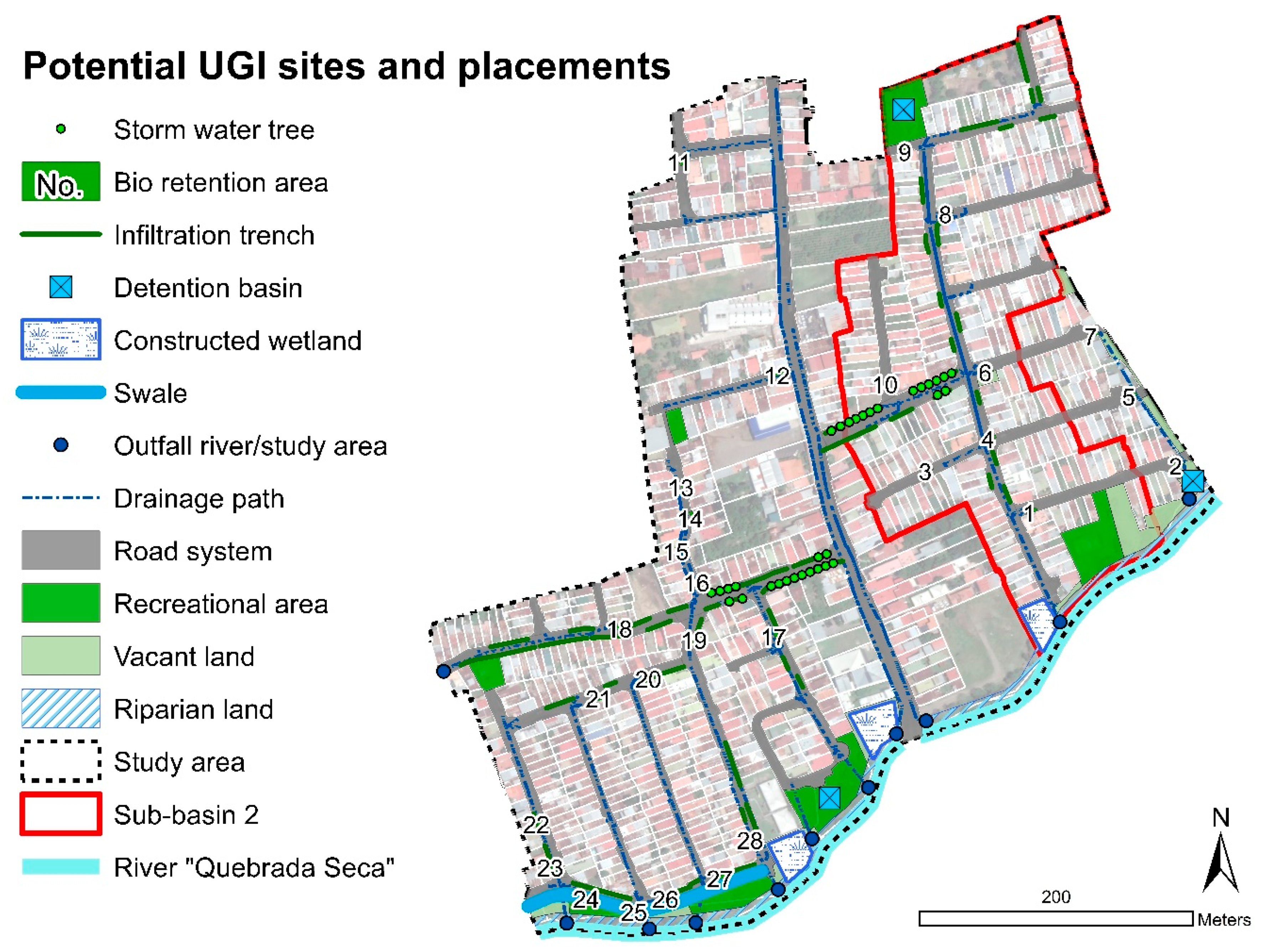
| UGI Element | Number or Length of Elements | Storage Capacity [m3] | Total Storage Capacity [m3] |
|---|---|---|---|
| Stormwater tree | 13 elements | 1.8 | 24 |
| Bio-retention area | 7 elements | 16.8 | 118 |
| Infiltration trench | 316 m | 0.27 per meter | 85 |
| Detention basin | 1 element | 1394 | 1394 |
| Constructed wetland | 1 element | 884 | 884 |
| Total | 2505 |
| Rainfall’s Statistical Return Period (Years) | Rainfall Amount [mm] | Runoff Rainfall [m3] | Total Storage Capacity [m3] | Potential Runoff Storage (%) 1 |
|---|---|---|---|---|
| 2 | 78 | 7472 | 2505 | 34 |
| 5 | 98 | 9385 | 2505 | 27 |
| 10 | 113 | 10,820 | 2505 | 23 |
| Indicator of Ecological Multifunctionality Dimension | Achievement through Full UGI Implementation | Remarks |
|---|---|---|
| Increase of green space (excluding riparian land) [%] | 2.2 | Additional green space provided by bio-retention areas and stormwater trees |
| Length of roadside greenery activated [m] | 1500 | Infiltration trenches and stormwater trees |
| Area of above-ground vegetated elements created [m2] | 3446 m2 of wetland area, 2948 m2 of bio-retention areas, 99.2 m2 of stormwater tree pits | 3 constructed wetlands, 28 bio-retention areas, 32 stormwater trees |
| New habitat types created [-] | 3 | Constructed wetlands |
| Change of Road Type | Length of Road Type Change [m] | UGI Traffic-Calming Options Gained Due to Road Type Change |
|---|---|---|
| 2 → 3 | 350 | Bio-retention area, swale, stormwater trees |
| 3 → 4 | 750 | Bio-retention area, swale, stormwater trees, permeable pavement |
| 4 → 5 | 100 | Permeable pavement |
Publisher’s Note: MDPI stays neutral with regard to jurisdictional claims in published maps and institutional affiliations. |
© 2021 by the authors. Licensee MDPI, Basel, Switzerland. This article is an open access article distributed under the terms and conditions of the Creative Commons Attribution (CC BY) license (http://creativecommons.org/licenses/by/4.0/).
Share and Cite
Fluhrer, T.; Chapa, F.; Hack, J. A Methodology for Assessing the Implementation Potential for Retrofitted and Multifunctional Urban Green Infrastructure in Public Areas of the Global South. Sustainability 2021, 13, 384. https://0-doi-org.brum.beds.ac.uk/10.3390/su13010384
Fluhrer T, Chapa F, Hack J. A Methodology for Assessing the Implementation Potential for Retrofitted and Multifunctional Urban Green Infrastructure in Public Areas of the Global South. Sustainability. 2021; 13(1):384. https://0-doi-org.brum.beds.ac.uk/10.3390/su13010384
Chicago/Turabian StyleFluhrer, Tanja, Fernando Chapa, and Jochen Hack. 2021. "A Methodology for Assessing the Implementation Potential for Retrofitted and Multifunctional Urban Green Infrastructure in Public Areas of the Global South" Sustainability 13, no. 1: 384. https://0-doi-org.brum.beds.ac.uk/10.3390/su13010384