2.1. Design of Public Space and Walkability
The design and quality of public spaces have a great influence on walkability. Studies showed that the quality of public spaces is more important than their numbers or sizes in promoting walkability [
22,
23]. High-quality public spaces were identified as the most important contributing factor in the social life of people and, therefore, in increasing the walkability rate in the neighbourhoods. The use, access, frequency of use by people and the strategic location of each public space in a neighbourhood affects the quality and attractiveness of public spaces, and people’s motivation to walk.
Various factors in the design of public spaces can affect the walkability of the built environment. Pedestrian safety is fundamental to be taken into consideration. A well-designed street should keep pedestrians safe from vehicular traffic by providing proper sidewalks, curbs, signals and markings [
24]. Universal design principles should be incorporated for creating an inclusive environment which is barrier-free and accessible by all to cater to the needs of vulnerable groups, including people with disabilities and older adults [
25].
Public spaces should be provided with adequate lighting specifically during the night for illumination [
26]. Aside from actual safety, pedestrians must be safe from crime or danger. An active street life enables a safer walkable environment due to the existence of people and “plenty of eyes on the street” for surveillance [
27]. Crime prevention through environmental design strategies should be incorporated in the design of public spaces to enhance visibility for natural surveillance and deter crime by enhancing the perceived risk of detection [
28].
Another design factor in creating walkable cities is the scale of public spaces that can be enhanced if the human scale is taken into account. Wide motorways full of noise, dust and fumes discourage people to pass. Instead of being used predominately by vehicles, streets are recommended to be designed in a pedestrian-friendly manner. The width of sidewalks should be wide enough for people to walk comfortably and can be wider to facilitate social interaction and other activities [
29,
30]. Trees and vegetation can be added to enhance the microclimate of public spaces [
31]. The appropriate use of street furniture, lighting, signage and paving all contribute to the enhancement of a walkable urban environment [
32]. A vehicle-free policy has been actively promoted worldwide to convert selected streets through pedestrianisation [
33,
34,
35]. Pedestrianised streets encourage walking and foster social and cultural activities to take place.
2.1.1. Density and Walkability
Gehl noted that higher densities in urban areas lead to revitalization and liveliness of communities, and increase the tendency towards choosing walking over other means of transportation means (car, bus, train, etc.) [
36,
37]. Density is a key concept in urban design and planning. Referring to the planning proposals of Le Corbusier, such as Ville Contemporaine (Contemporary City) in 1922 and the Plan Voisin in 1925, high density was one of the fundamental principles in creating walkable cities. In Ville Contemporaine, Le Corbusier proposed to erect 24 identical skyscrapers of 60-storeys high, each in a rigid grid pattern, but each skyscraper was erected at wide intervals on a vast open space with merely 5% site coverage (leaving 95% of the land left open and unbuilt) [
38].
Compared with Le Corbusier’s modernist tower typology, Jane Jacobs, in her seminal book,
The Death and Life of Great American Cities, advocated a high-density low-rise approach. Using Greenwich Village as an example, the high density of more than 200 dwellings per acre was achieved by having a site coverage of up to 80% (leaving the remaining approximately 20% of the land left open and unbuilt) [
27]. Therefore, building height itself is not an indication of density. A 10-storey building on 10% of the site has the same floor area as a single-storey building with 100% site coverage [
39]. The ratio of floor area to land area or ‘floor area ratio’ is a common measurement of building density but without a direct correlation with population density. The measurement of density as dwellings per acre or dwellings per hectare is also commonly used but depends on the size of dwellings and the size of households [
40].
Population density based on census data about residents per hectare does not provide a clear picture of the actual concentration of people in the city. Population density fluctuates throughout the day and can vary quite substantially between working days and weekends. Therefore, no single density measure is useful in understanding walkability [
39]. Instead of using density, Jacobs referred to “dense concentration of people” as one of the conditions for urban diversity and intensity because bringing people of different ages, abilities and ethnicities is “needful for flourishing city life” and “a visibly lively public street life” [
27].
A dense concentration of people is a necessary condition for urban diversity and intensity but not a sufficient condition by itself. Other factors of having a proper pedestrian network and a mixed use of spaces are crucial for achieving a walkable built environment.
2.1.2. Street Connectivity and Walkability
Some studies used observational tools to assess the effect of street connectivity and streetscape characteristics [
41,
42]. By contrast, other studies used geographic information system (GIS) to measure the impact of the enclosure and human scale on walkability experience [
43]. The common finding of these studies is that street connectivity, level of vegetation and leaf area index have significant effects on street walkability.
Connectivity of path network correlates with street patterns. Grid street patterns with equal-sized square or rectangular blocks provide ease of movement for pedestrians, whereas dead-end streets and cul-de-sacs create very limited connection and access points [
44]. Although cul-de-sacs do not allow vehicles to pass through, they can be connected to pedestrian networks if publicly accessible easement or right-of-way exists. Aside from dead-end streets and cul-de-sacs, other potential barriers to pedestrian access include busy motorways, rivers, slopes or other topographic features [
45].
The street pattern is associated with block size. When block size becomes smaller, the urban structure becomes finer and better connected with many intersections. Jacobs pointed out that “frequent streets and short blocks are valuable because of the fabric of intricate cross-use that they permit amongst the users of a city neighbourhood” [
27]. Short blocks enhance connectivity by offering additional opportunities to turn corners and alternative path choices to walk.
The walkability of the built environment is enhanced if the pedestrian network is connected to public transportation modes. This facilitates people to take public transport, reduces car dependency and increases the pedestrian flow. Moreover, if destinations within walking distance are well connected, then people will be encouraged to walk rather than drive. Jacobs and Pafka used the phrase “pools of use” to refer to the zone accessible by walking at a particular urban location measured by distance or time [
27,
39].
In addition to street connectivity, the streetscape and its scale also play important roles in encouraging walkability in cities. Some studies used observational tools to assess the effect of streetscape characteristics on walkability [
41,
42]. The findings of these studies showed that street trees and leaf area index block the sight and mitigate the scale of buildings and wide streets, thereby further enhancing the built environment for pedestrians [
46]. Other studies used GIS to measure the effect of the enclosure and human scale on walkability experience [
43]. Franck and Stevens showed that the human-scaled neighbourhood plays an important role in promoting the number of interactions in urban spaces and therefore significantly affects the walkability index [
47].
2.1.3. Mixed-Use Development and Walkability
The influence of dense and mixed-use development on social life and walkability has been well established in the literature [
27,
36,
48]. Gehl showed that small-scale cities with dense and mixed-use urban morphology host a higher number of city events and encourage people to walk further to observe these social events and day-to-day activities [
36]. The positive effect of mixed-use development, integration of commercial with residential zoning and physical qualities (urban furniture, sidewalks) on social life and walkability was confirmed [
49]. Modernist urban planning encouraged a clear demarcation of zoning for different functions. From the Plan Voisin of Le Corbusier [
38], a large part of central Paris was proposed to be demolished under urban renewal and replaced by a group of office skyscrapers surrounded by parkland. The use of vehicles as a means of transportation was promoted by wide motorways, and the city was divided into commercial, residential, cultural and industrial areas.
Jacobs strongly criticised the tabula rasa approach and clear segregation of mono-functional zones of modernist urban planning [
27]. Jacobs stressed the importance of mixed uses through detailed observations of everyday urban life. Jacobs noted that “To understand cities, we have to deal outright with combinations or mixtures of uses, not separate uses, as the essential phenomena”. In addition, Jacobs distinguished two types of mixed-use diversity, namely, primary and secondary uses. The former bring people to specific places, such as offices, dwellings and factories. A popular restaurant and even a small family café can draw people as primary uses. Secondary uses refer to the enterprises that grow in response to the presence of primary uses, and the primary uses draw in response to a variety of users’ needs to serve the people. Regardless of how successful primary and secondary uses are, city diversity is only achieved when different uses are combined and mixed [
50].
Apart from having mixed uses in close proximity with one another, the activities to be concentrated within a particular time of the day should be avoided. An appropriate functional mix can attract people to go outdoors on various schedules. When people walk on the streets and use public spaces at different times of the day, the city is much safer and more enjoyable [
51]. The 24-h city concept has been developed in some areas to bring a wide range of groups back to city centres after office hours through mixed-use programmes [
52].
In the past, traditional cities were compact with narrow streets, and pre-occupied with human activity. Today, many of these cities are adapted to accommodate the car with wider roads, more car parking spaces, and lower population densities, with space between urban buildings reserved for automotive use. Lower population densities meant urban sprawl with longer distances between places. This process led to changes in urban form and street connectivity that offered little opportunity for people without a car, made older transport unattractive or impractical, created further car dependency, and finally resulted in reduced level of walkability. Moreover, falling energy prices and rising car ownership have further transformed cities, allowing the increased physical separation of activities and the progressive spread of urban hinterland at lower densities. The next section provides an overview of the key urban design elements that made Iranian traditional cites into walkable cities.
2.2. Key Urban Design Elements in Iranian Traditional Cities Contributing to Walkability
Habibi stated that urban design and planning can be divided into pre-Islamic (9 BC–7 AD) and post-Islamic (7 AD–today) periods in Iran [
53]. Urban design features and elements belonging to the pre-Islamic period have been mainly collected through archaeology. According to the archaeological evidence, a diverse range of urban forms, patterns and morphologies were identified due to the presence of different emperors ruling the country in pre-Islamic Iran [
53]. After the Arabic invasion to Iran, new types of urban patterns and morphologies were added to Iranian cities, which were mainly inspired by the pre-Islamic concepts in city planning. These new urban forms and urban design elements made the Iranian cities unique and distinctive from other traditional cities in the world. In this study, traditional Iranian cities refer to the cities that have been formed and developed within the post-Islamic period. In this section, a brief overview of the prevailing urban morphology in traditional Iranian cities will be provided and each urban design element that contributes to walkability will be discussed.
The number of people per house was higher in the past than today in Iranian traditional cities, as people tended to have more children and all family members used to live together, even after marriage. This case is in contrast to today’s societies where people live in dispersed suburbs and mainly rely on their vehicles to reach their destinations. The car dependency is known as the main source of lack of vitality, public social life and walkability in today’s cities [
27]. The presence of bazaars in traditional Iranian cities and their proximity to the mosque (the core and heart of the cities),
mahalleh (residential quarters),
madrasah (school),
maidan (square) and
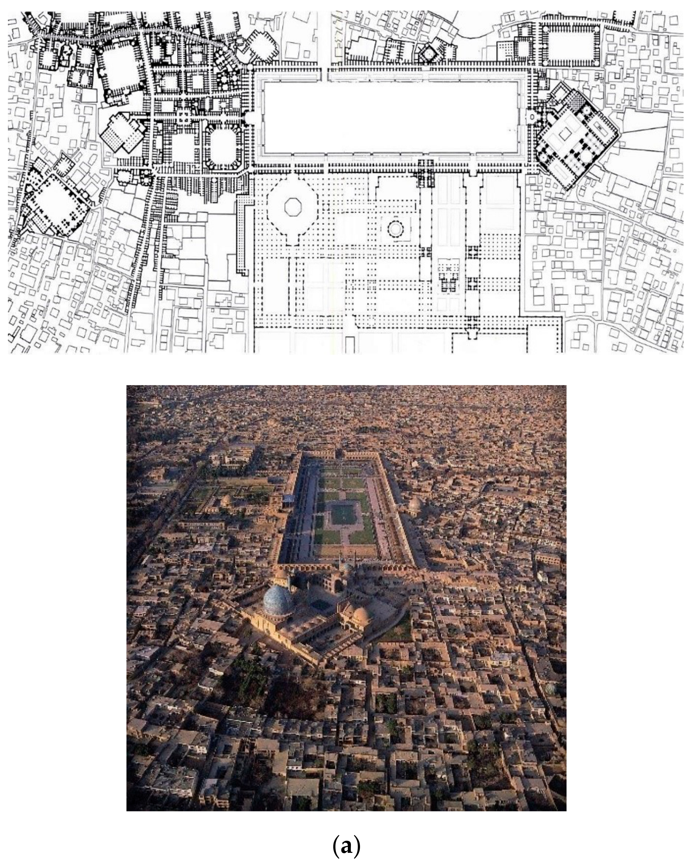
hammam (public bath) through connected and permeable alleyways created an urban life in which all of the neighbourhood’s daily needs could be responded within walking distance. Taking the heritage part of Shiraz city (a city located in the central part of Iran) (also known as old Shiraz) as an example, all the uses and requirements of the people’s everyday life were located within a 1 km radius from the centre of the city (which was the community mosque). In the old city of Shiraz, people often walked from their homes to communal and public spaces, and the use of cars was only limited to travelling to the outskirts of the cities. Aside from walking distances, the quality of sidewalks and the provision of thermally comfortable outdoor spaces through shaded narrow alleyways were other factors that encouraged people to walk in the city.
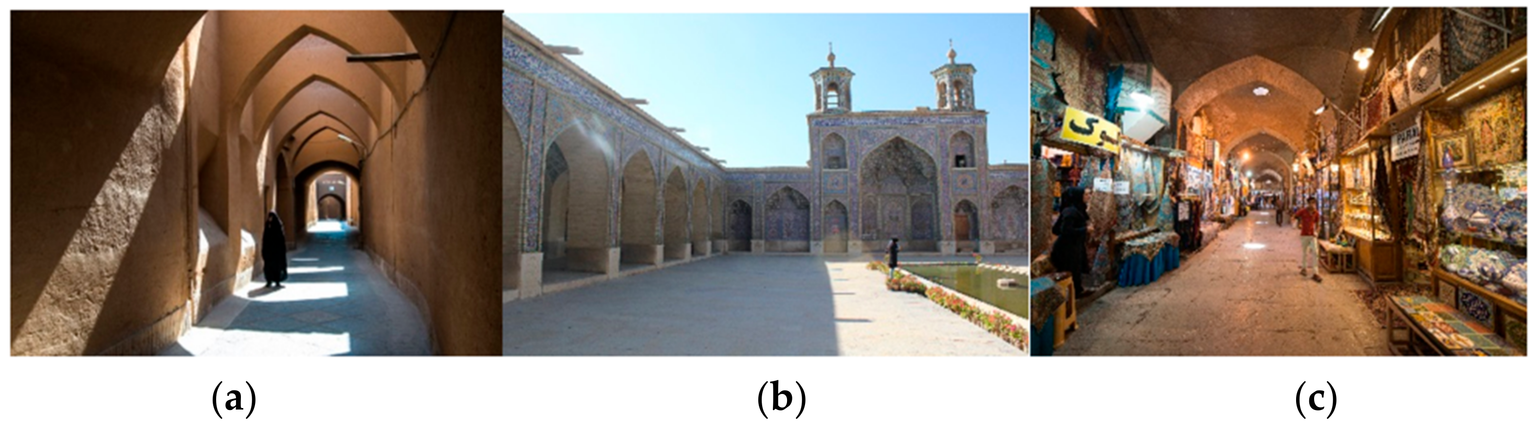
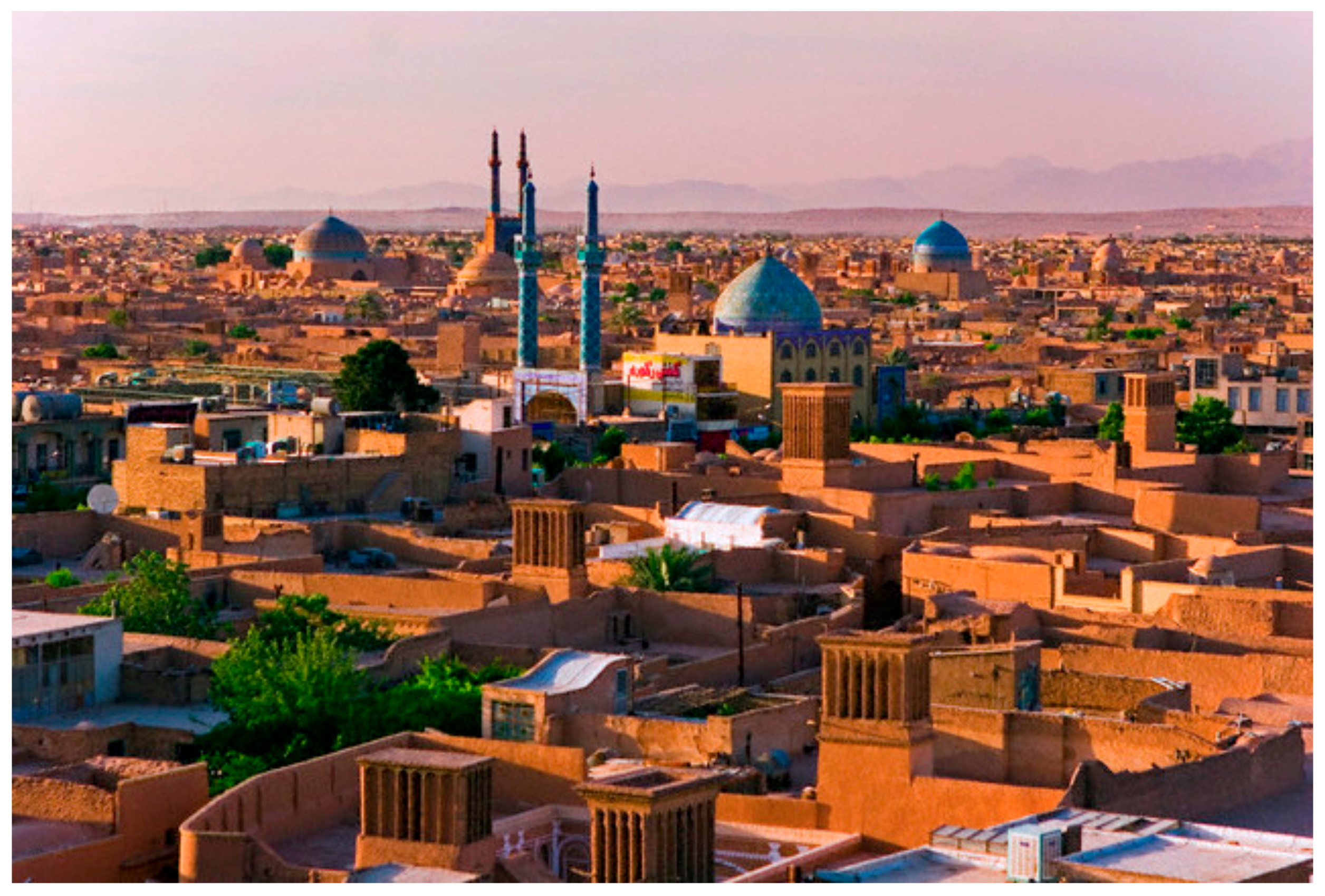
Iranian traditional cities were formed organically with respect to the background climatic conditions and therefore considered as human-scaled built environments. The examples of such spaces are the alleyways in the old city of Yazd, Nasir al-Mulk Mosque in Shiraz and Qeysarriyeh Bazaar in Isfahan (
Figure 1).
In Iranian traditional cities, houses were limited to one-storey height, and the narrow-shaded alleyways provided friendly and comfortable routes for a day-to-day journey of urban dwellers. A human-scaled design, narrow alleyways and connected public spaces (with bazaar and mosque in the central axis) enabled people to greatly observe the public spaces, details, shops and all activities from a close distance.
In Iranian traditional cities, public space played an important role in creating walkable neighbourhoods. The public spaces were pleasurable to inhabit and practical enough to use for day-to-day life. Therefore, public spaces greatly contributed to an increased level of walkability and promoted a sense of identity in these cities. The number of the public spaces in a neighbourhood, the level of their accessibility and the quality of public space were the main factors in encouraging people to walk from their homes to the urban areas or neighbourhood centres.
In the past, public spaces were mainly used for market purposes and social, religious or political events. These spaces were also known as the main place for communicating and interacting with other urban dwellers and trading, and were regarded as the heart of the community [
54]. Today, these functions somehow have been replaced by privatised public realms designed and developed by certain agencies who do not often consider the neighbourhood’s unique contextual features. This case is the main reason why people are less willing to walk from their homes to the neighbourhood centres or the other public spaces in their communities.
In traditional Iranian cities, three main pillars form the basis of urban life, namely, religion (mosque), trade (bazaar) and family (house) [
54,
55,
56]. These pillars were formed after Arab’s invasion to Iran and followed by a transformation, which was made to address the Islamic belief systems and theories in urban planning.
One of the most significant components of the religion pillar was the community mosque, which was indeed a replacement for Zoroastrian fire temples [
56]. In Iranian traditional cities, the overall urban morphology and diverse range of public spaces increased the interactions amongst people with different socio-economic backgrounds. In addition to their primary uses, these public spaces were able to act as third places. Oldenburg and Brissett described the third place as a place of refuge other than home or workplace, where people can relax, commune and interact [
57]. A third place satisfies social needs where one can meet friends, colleagues, neighbours and even strangers.
As mentioned, in traditional Iranian cities, three main pillars form the basis of urban life, namely, religion (mosques), trade (bazaars) and family (houses and residential quarters). Therefore, in the next section of this study, we will provide an overview of each of these urban design elements and discuss how these pillars contributed to walkable neighbourhoods.
2.2.1. Mosques
The most important public space in Iranian traditional cities is a mosque. Mosques did not only provide worship places for people but also catered for society’s need for social life. Mosques were often integrated into central marketplaces (bazaars). This integration increased the vital role of the mosque towards creating a public realm that worked well with the daily commercial activities in the city.
As the main communal and public spaces of the community, community mosques were located in a central position in the city [
58] and linked to other main public spaces in the city (e.g., bazaar, residential quarters [
mahalleh], square [
maidan, similar to Roman Forum],
hammam [public bath] and
madreseh [school]). Each
mahalleh had their own mosque in the central location.
The community mosque was also located next to the governmental palace and bazaar and therefore provided a high level of accessibility and connectivity from one function to another. As a result, the community mosques were also known as one of the most important gatherings and interaction spaces, where people could discuss various social, economic and political issues, regardless of their socio-economic background. In addition, mosques, which were attached to
madresehs (schools), had a dual function serving some flexible spaces as a school and functioning as educational hubs for learners. Until the beginning of the 20th century, mosques and schools had mostly been an integrated space with integrated functions. A variety of uses near the mosque and the physical and visual connectivity amongst them promoted walkability in traditional Iranian cities. Therefore, people were highly encouraged to take part in social life and walk through the interconnected mosque, bazaar and
madrasah. In Shiraz, for example, the only government-built mosque was Vakil Mosque, which is located next to the Vakil bazaar (
Figure 2). A
bazarcheh and the
madreseh can be found next to each local mosque, serving as public amenities and providing high-quality public spaces which in turn led to high walkability.
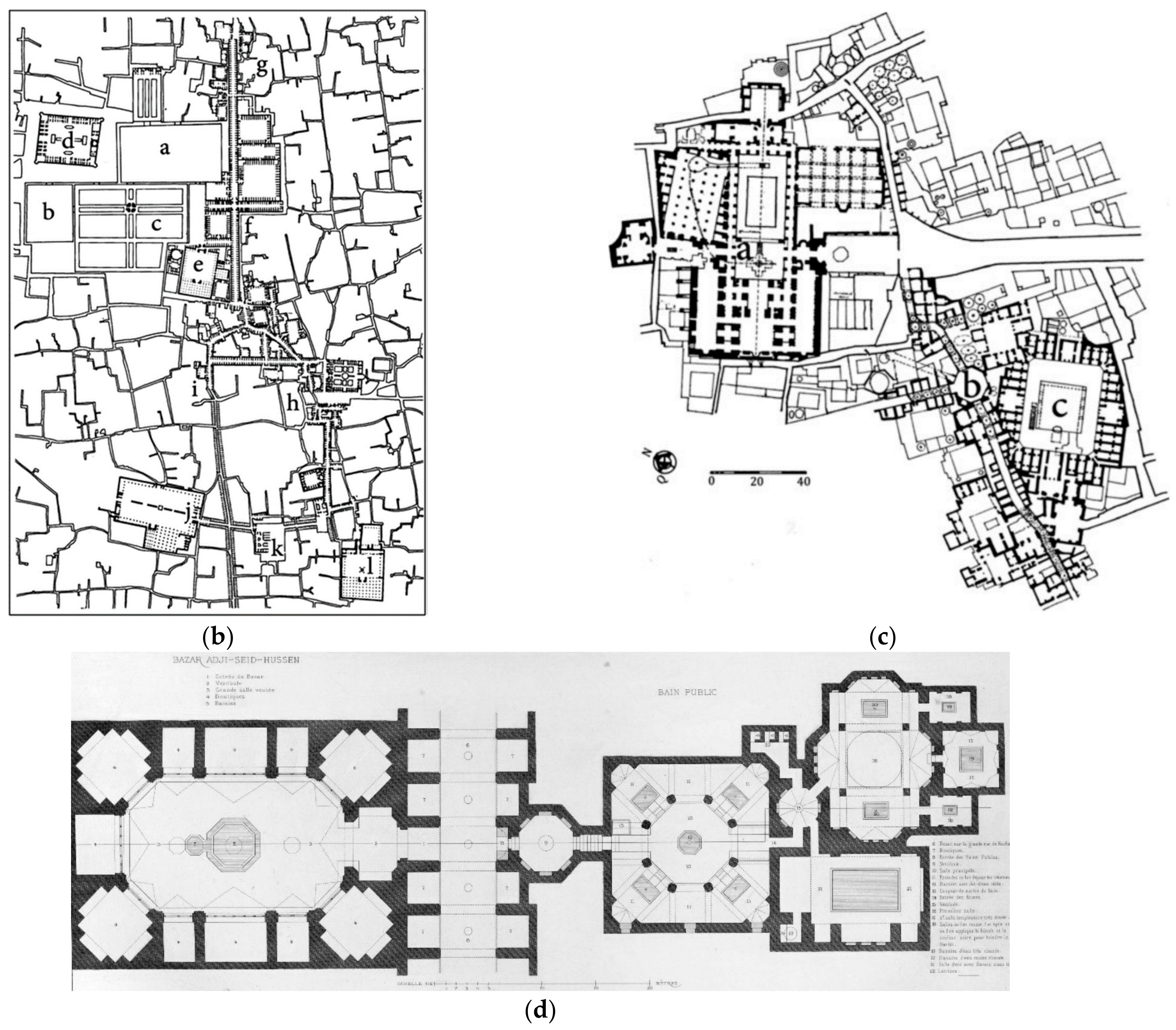
2.2.2. Bazaars
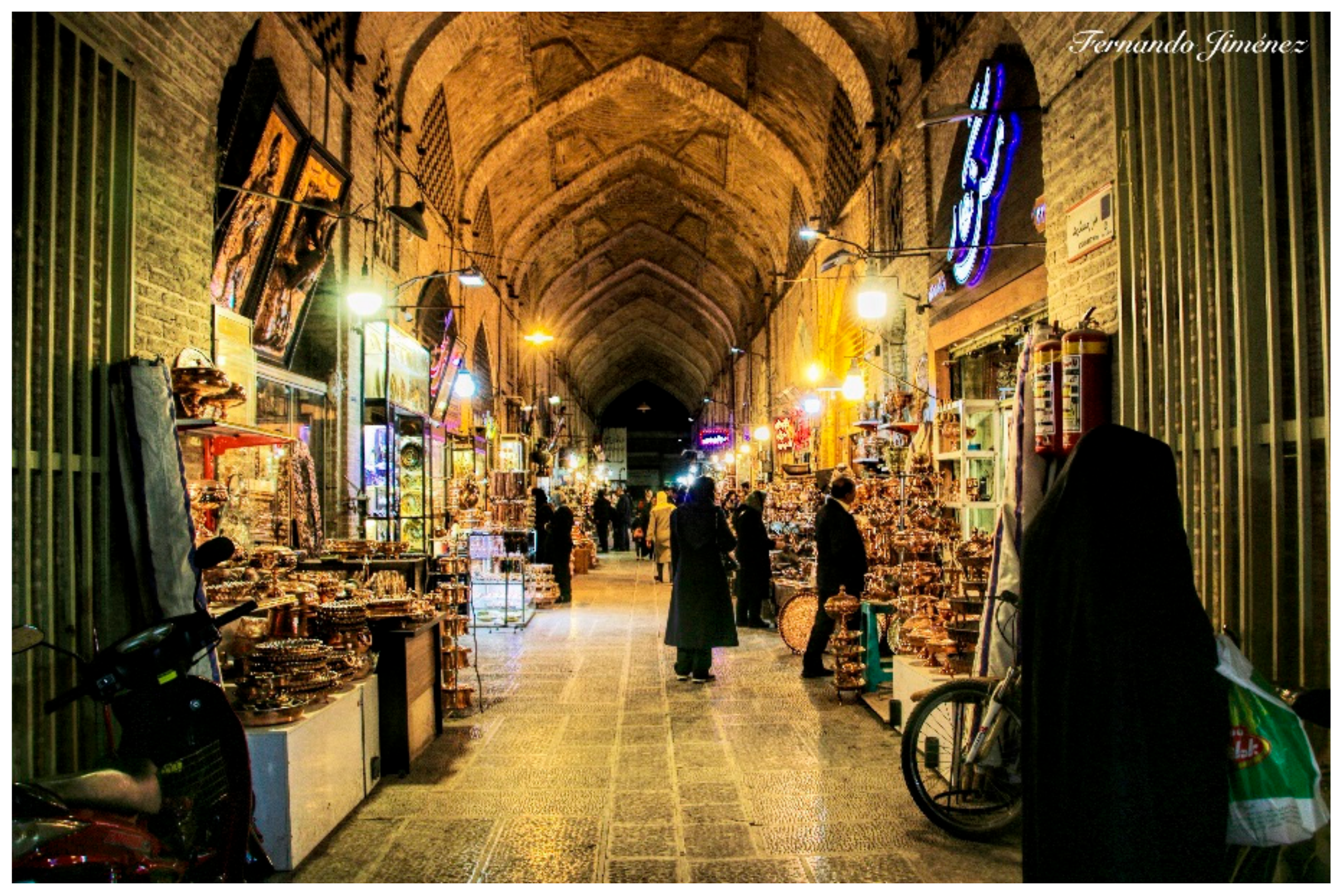
The second urban design element that contributed to walkable communities in Iranian traditional cities was the bazaar and its physical and structural integration with mosques. The bazaar was also known as “the second heart of the city” in traditional cities of Iran [
59]. Additionally, the bazaar was the most significant spatial axis in the social life of cities [
60] and was first introduced by Medes and Achaemenids during the ancient Persian Empire [
54]. In fact, bazaars and mosques are known as the two major lungs and the backbone of Iranian traditional cities.
Bazaars had mainly a linear form [
55] and were situated in the central part of the city. Each residential quarter had their own minibazaar, known as bazarcheh. Bazarches were connected to the main mosque from one side and to
mahallehs (residential quarters) from the other side. Moreover, they were the main destination for all the major pedestrian pathways [
56,
61]. Bazaars had commercial and manufacturing uses and also fulfilled the needs of people to interact and discuss the political, social and economic status of their cities [
55]. Bazaars played a key role in connecting the residents of the city with major public spaces and outsiders [
62].
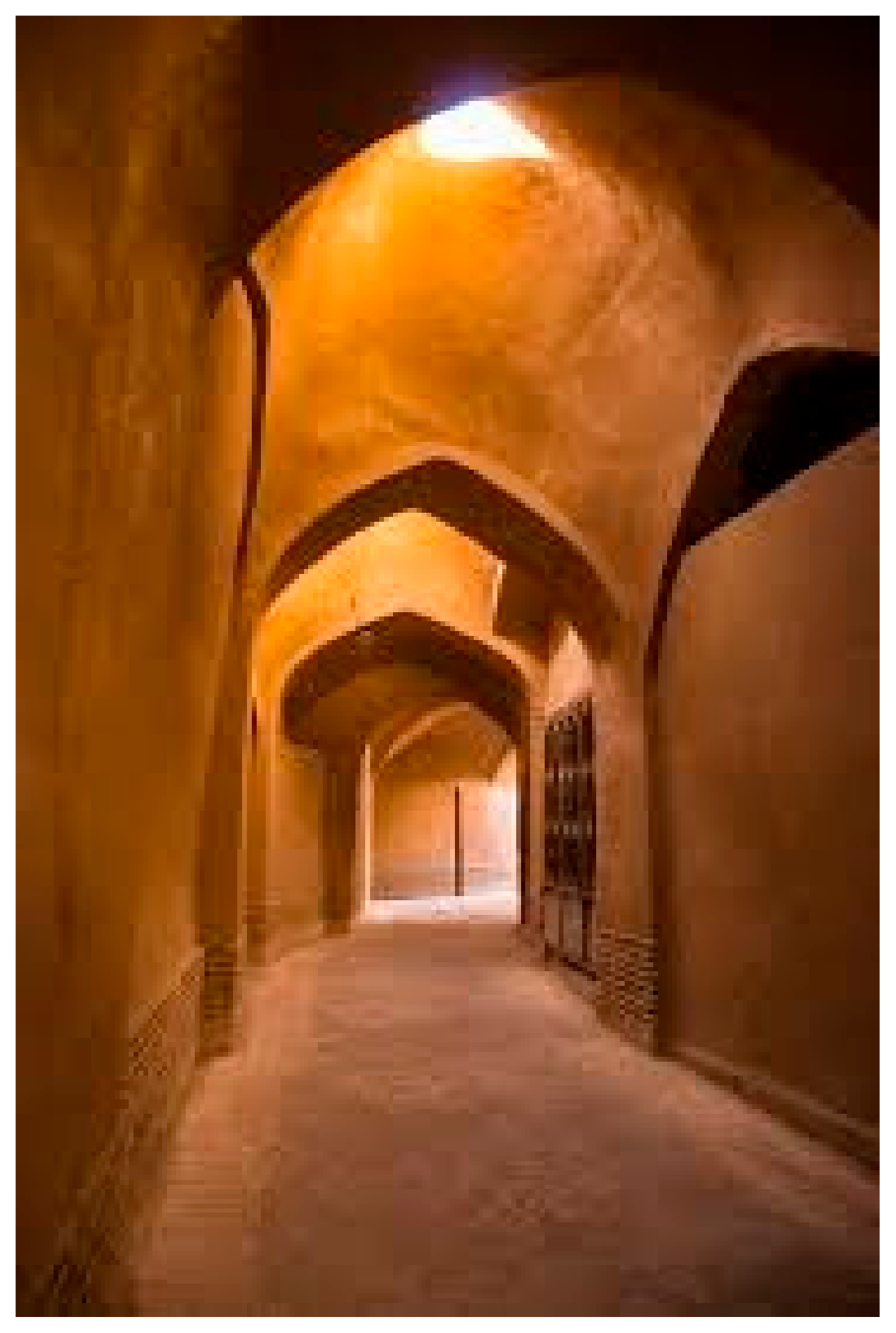
Although the alleyways and houses were built for protection, the attached mosques and bazaars enabled a further level of walkability by providing a high level of various activity patterns, increased active frontages (shops) and the creation of series of open public realms in between. In this important urban element of Iranian traditional cities, the nature of the bazaar as the heart and the core of the city with diverse types of activities and the provision of thermally comfortable spaces resulted in the highest level of pedestrian walkability. The shaded storefronts accommodated gathering spaces in bazaars and narrow covered passageways with low sky view factors contributed to better thermal comfort for pedestrians and therefore increased level of walkability (
Figure 3). As the main social and pedestrian network of the city, the bazaar played a vital role for hosting various public gatherings in the enhancement of city’s liveability and walkability.
2.2.3. Residential Quarters (Mahalleh) and Alleyways
Mahallehs in traditional Iranian cities refer to “the residential quarters that are scattered in the city” and are known as one of the main elements of social life in traditional Iranian urban planning [
63]. Although the residents of each
mahalleh had similar ethnicity, cultural and religious backgrounds [
56,
61], the
mahallehs were not segregated by any physical barriers, such as walls [
55].
Each
mahalleh had their local mosque,
hammam (bath),
bazarcheh (minibazaar) and other civic amenities, which made them walkable and accessible to the residents [
60].
Figure 4 shows the skyline of a residential quarter (
mahalleh), situated in the old city of Yazd.
Figure 4 also shows that this residential quarter is characterised by compact urban form and shaded, covered alleyways.
The connection between the
mahallehs (residential quarters) and bazaars (commercial quarters) was through a series of narrowed and covered alleyways, sometimes blocked by cul-de-sacs from one side [
61]. These alleyways were covered, mainly because of the security and protection against sun, wind and occasional rain, and for providing thermally comfortable urban spaces in hot-arid climates (the dominant climate in most of the traditional Iranian cities located in the central parts of Iran). Strategic openings along these narrow and shaded pathways avoided the creation of wind tunnel and reduced the wind speed in winter.
These covered alleyways enabled further protection against the invaders in case of breaking the fortification walls. The human-scale design principle of the alleyways also played an important role in encouraging further walkability in each
mahalleh. An example of such an alleyway is shown in the old city of Yazd in
Figure 5. In this
mahalleh, walkability was also supported by a strong pedestrian circulation network. These pedestrian networks had two main functions. Firstly, they were part of a transportation system in the city and provided access to different functions. Secondly, they acted as neighbourhood spaces by providing safety, continuity and thermal comfort.
The alleyways were narrower within the distances away from the bazaar [
64]. These alleyways were organically shaped, but their hierarchical structure is somehow differentiated from the private, public, semi-public and semi-private urban zones. For example, the parts near the cul-de-sacs were the gathering zones for the residents of neighbouring houses and were mainly used by housewives and as a children’s playground by the household’s children.
The housing typology in all the
mahallehs was introverted. These houses were attached by walls, indicating a strong emphasis on the segregation between indoor and outdoor (public and private zones) in traditional Iranian houses [
65]. Therefore, the role of public spaces, such as mosques, bazaars, schools and baths, was critical in creating a vibrant social life and promoting people to walk in their
mahallehs.
The building typologies of houses were mainly introverted, and the entrance to houses was the only interface between inside and outside domains (public and private zones).
Pîrneshîns can be observed next to the entrance doors of these houses, which were created next to the entrances of each house and were commonly known as communal spaces for neighbours to gather and speak to each other’. Pîrneshîn was a place for sitting, resting space for older adults and accommodating people who were tired of carrying heavy loads. This amenity automatically resulted in further social interactions and sense of community amongst people in traditional neighbourhoods, as it promoted face-to-face communication amongst neighbours.
In addition to
Pîrneshîns, most of the houses had fixed seating places in front of their doors, mainly for utilisation of older adults of the household or the community. This simple urban furniture somehow became a gathering space for older adults to get together and socialise with the neighbours passing by. This amenity also increased the level of passive surveillance in the neighbourhood which then led to secure urban spaces. These seating places are comparable with porches in Western architecture, where the residents perform their daily routine in a semi-private, semi-public zone. This notion is in line with the findings of Gehl’s study on the influence of front yards, informal seating spaces and urban furniture on encouraging walkability in a city [
66].
Each mahalleh had its own centre (neighbourhood centre), which was formed around a small public square (maidan). The purpose of mahalleh centre was to provide civic amenities and urban infrastructure, enhancing the sense of community and identity amongst each mahallehs’ resident. Although each mahalleh can cater for the needs of its residents, the connection between the mahallehs with public spaces was through the alleyways which enabled people to have easy access in different parts of their cities and walk to their destinations.
The level of walkability and social life in each mahalleh relied on the functionality and attractiveness of the mahalleh centre and its nearby elements, such as community mosque, bazarcheh and schools. Therefore, allocating a bazarcheh and a public bath near each mahalleh centre was mainly focused.
Traditional Iranian mahallehs consisted of a diverse range of uses located in proximity to each other and within walking distances. For example, in the old cities of Shiraz and Isfahan, we can observe how the residential, commercial, cultural and institutional uses are positioned next to each other and adjacent to the mahalleh centre. These uses provided the main attraction for the mahallehs’ residents to travel to these destinations, as they did not only address the daily needs of residents but also provided vibrant public spaces next to each other. Therefore, the mahalleh centre was considered a social hub that invited people for further interaction. The strategic positioning of these public spaces next to the mahalleh centre and their linkage with residential quarters via permeable and accessible alleyways were other factors in forming walkable neighbourhoods in traditional Iranian cities.
Notably, the design of the neighbourhood also considered the needs of people with special needs (disabled, older adults, children). Therefore, this design provided a variety of choices available in urban spaces for people with different needs and socio-economic backgrounds.


 ,
, 


