
Spatial Distribution and Evaluation of Arsenic and Zinc Content in the Soil of a Karst Landscape

 ,
,  ,
, 
Abstract
:1. Introduction
2. Materials and Methods
2.1. Primary Data
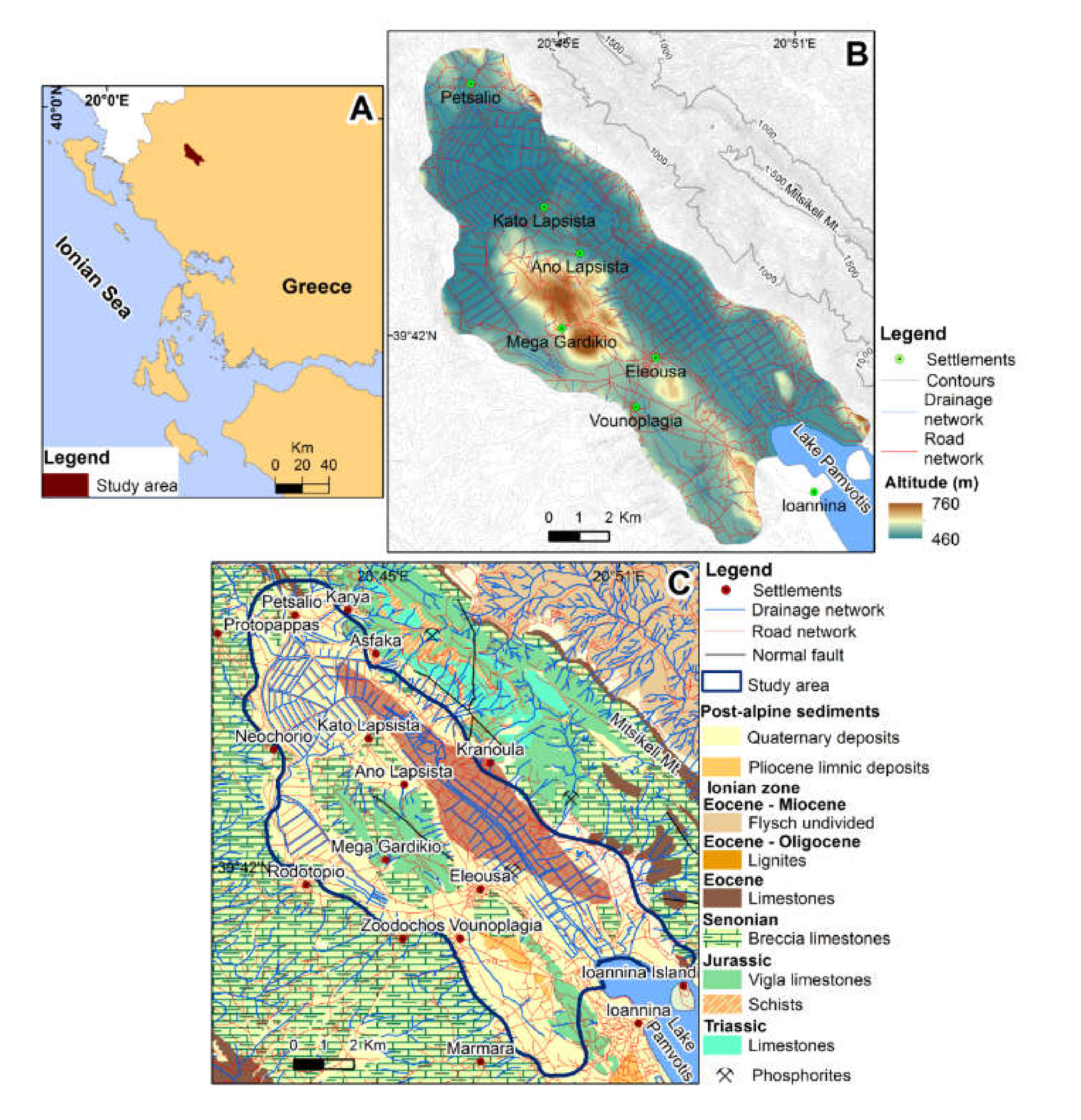
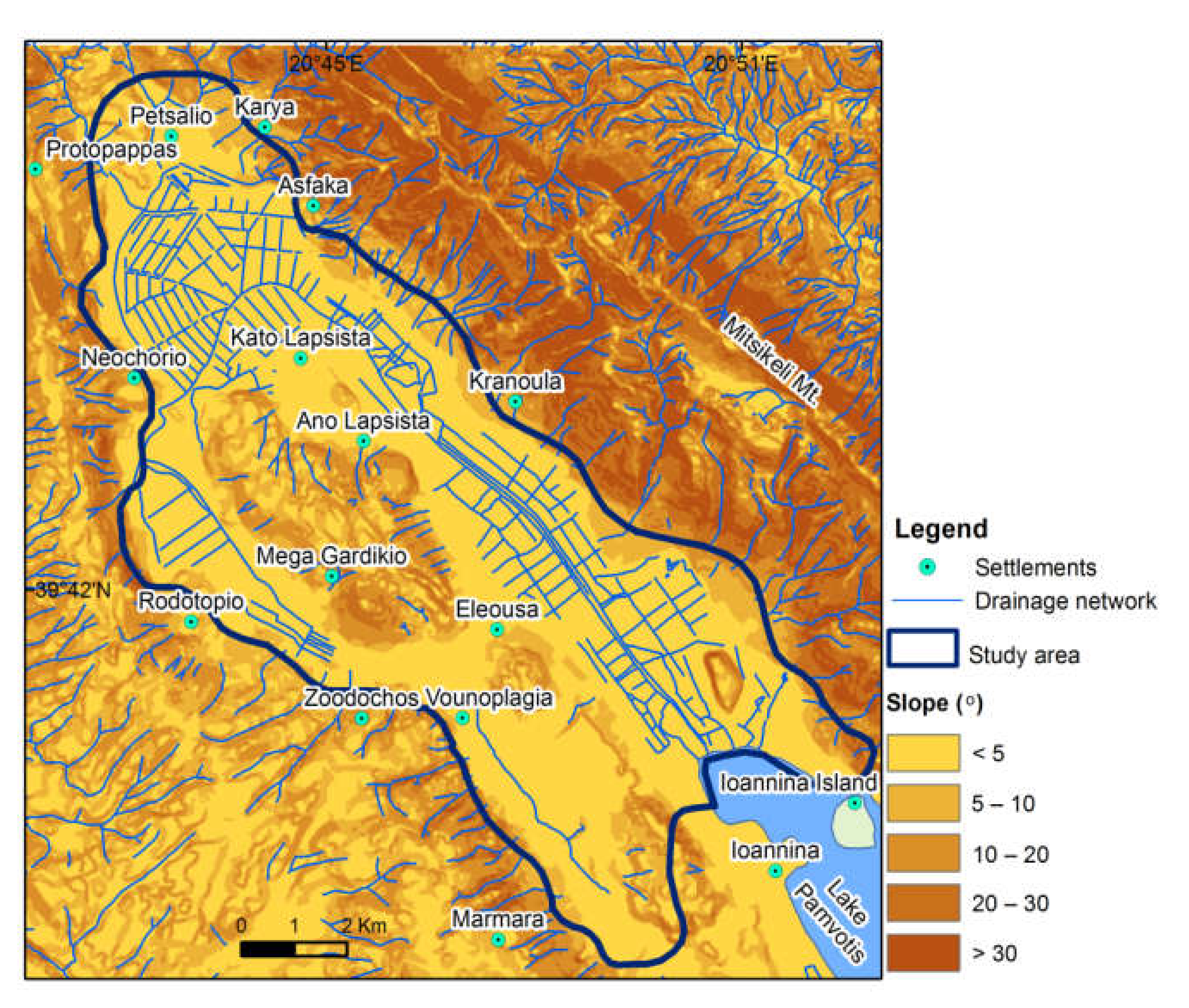
2.2. Study Area, Geological, Geomorphological, and Land Use Setting
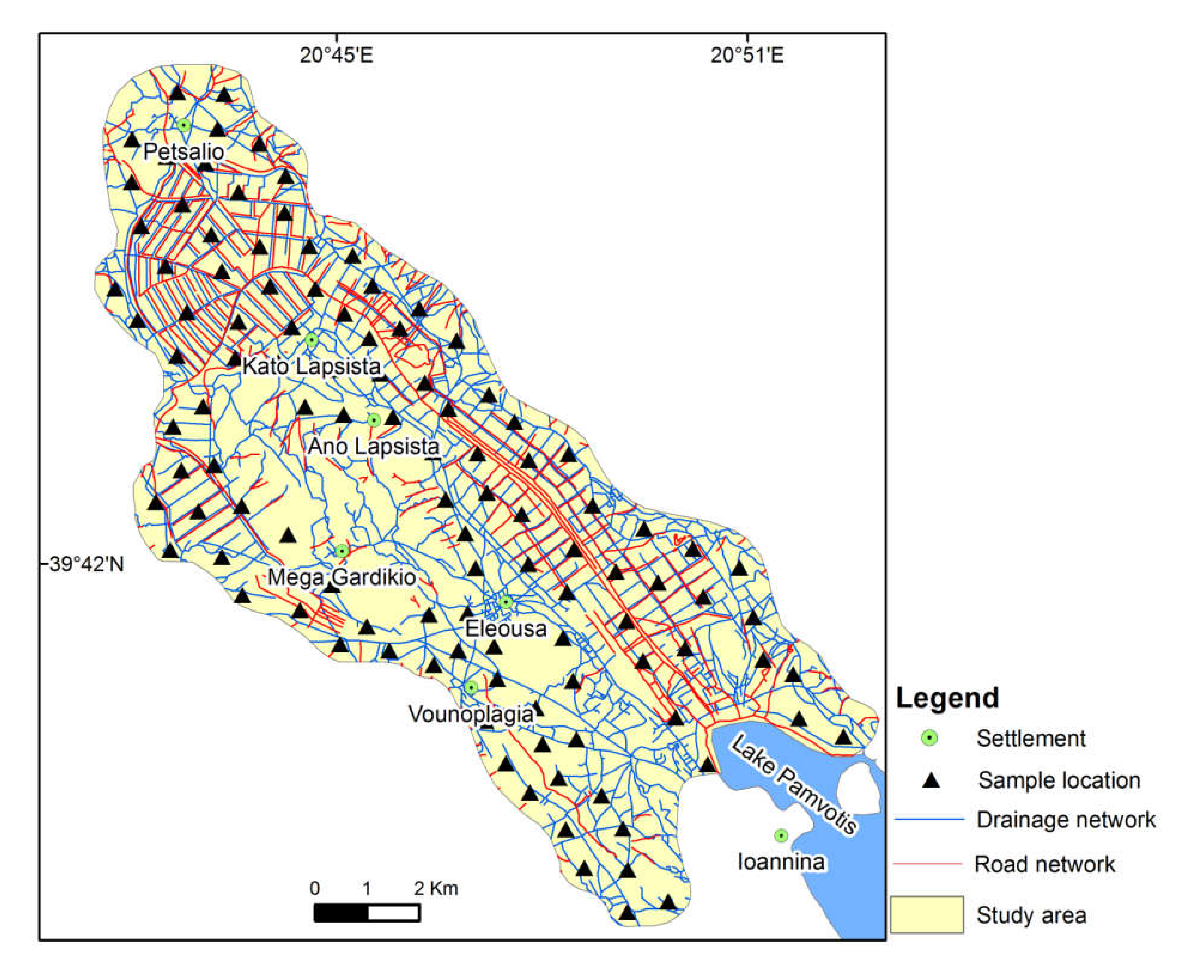
2.3. Soil Sampling and Laboratory Procedures
2.4. Data Treatment
3. Results and Discussion
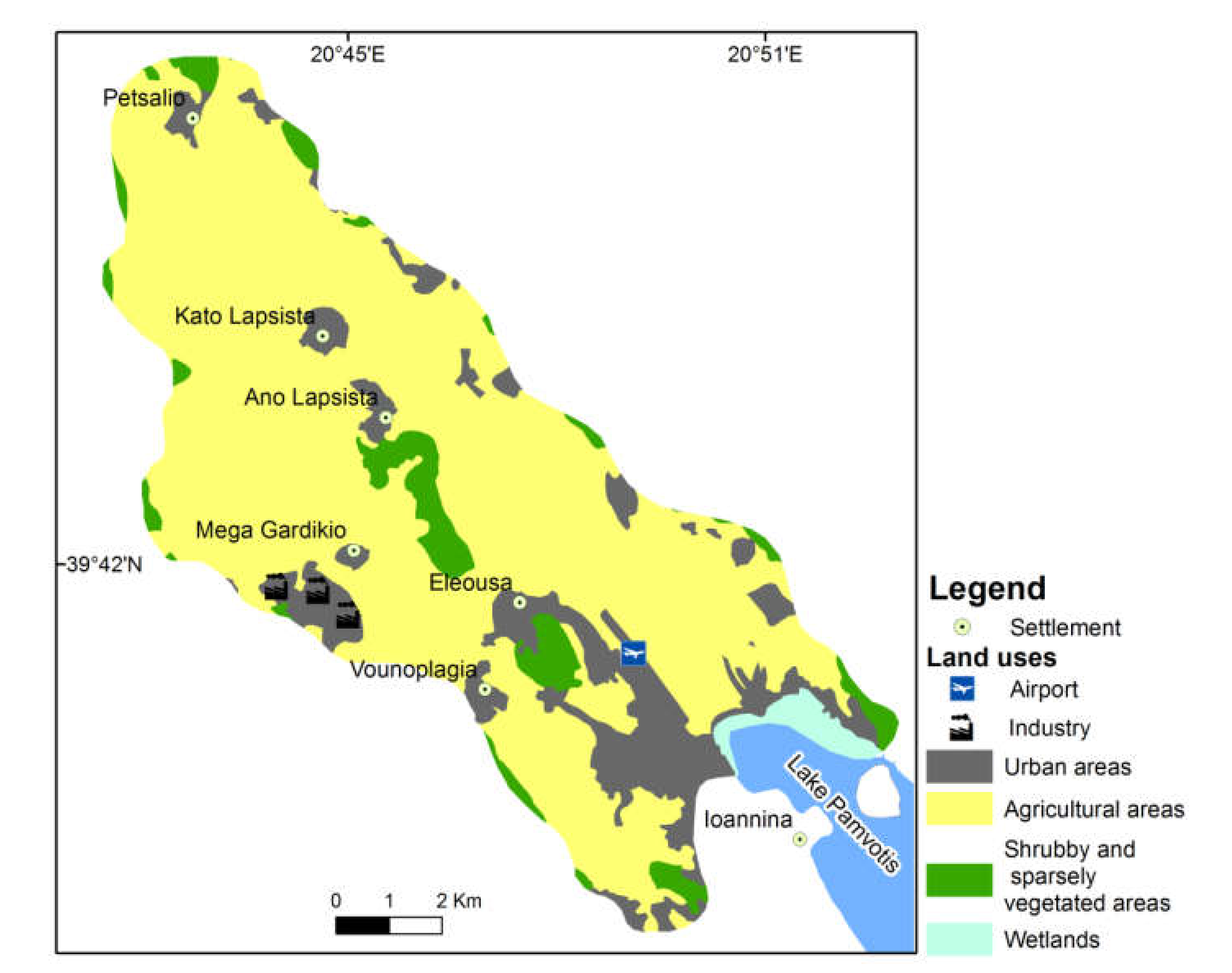
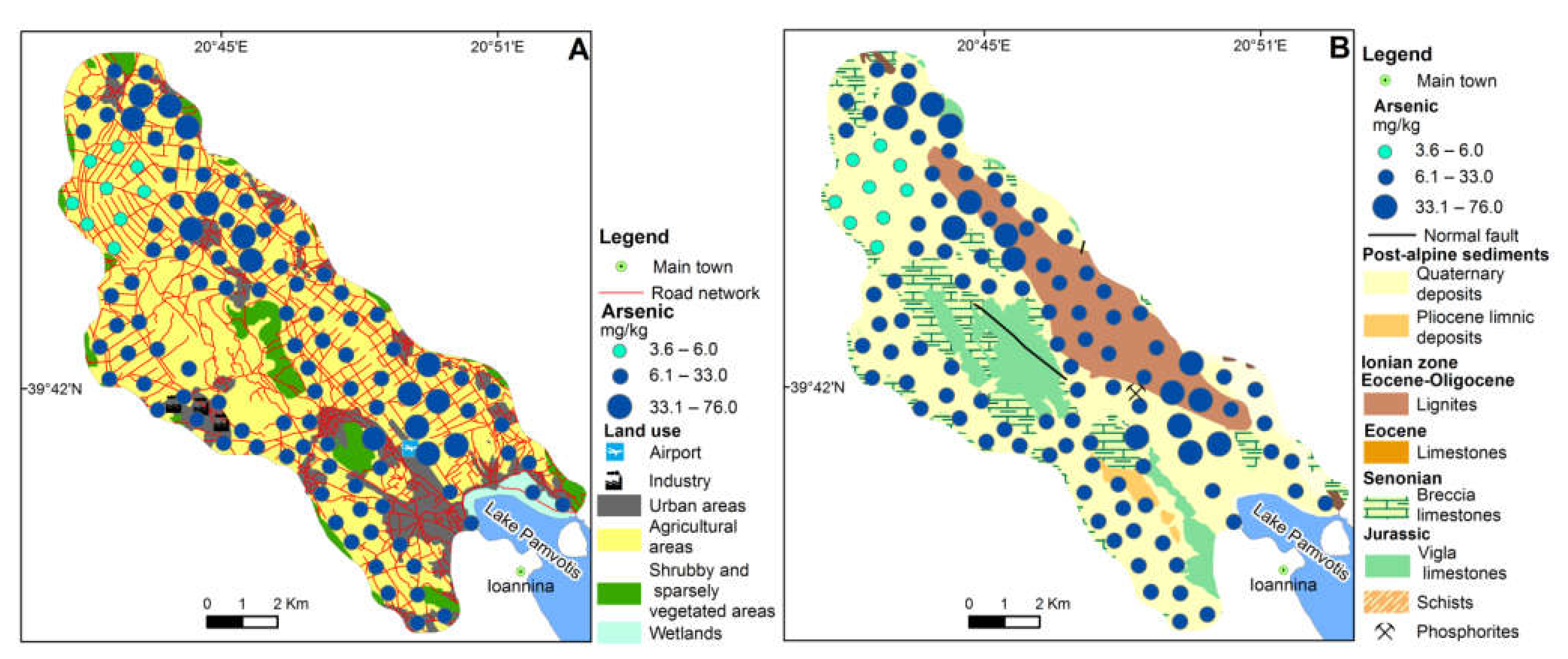
3.1. Geomorphologic and Land Use Characteristics
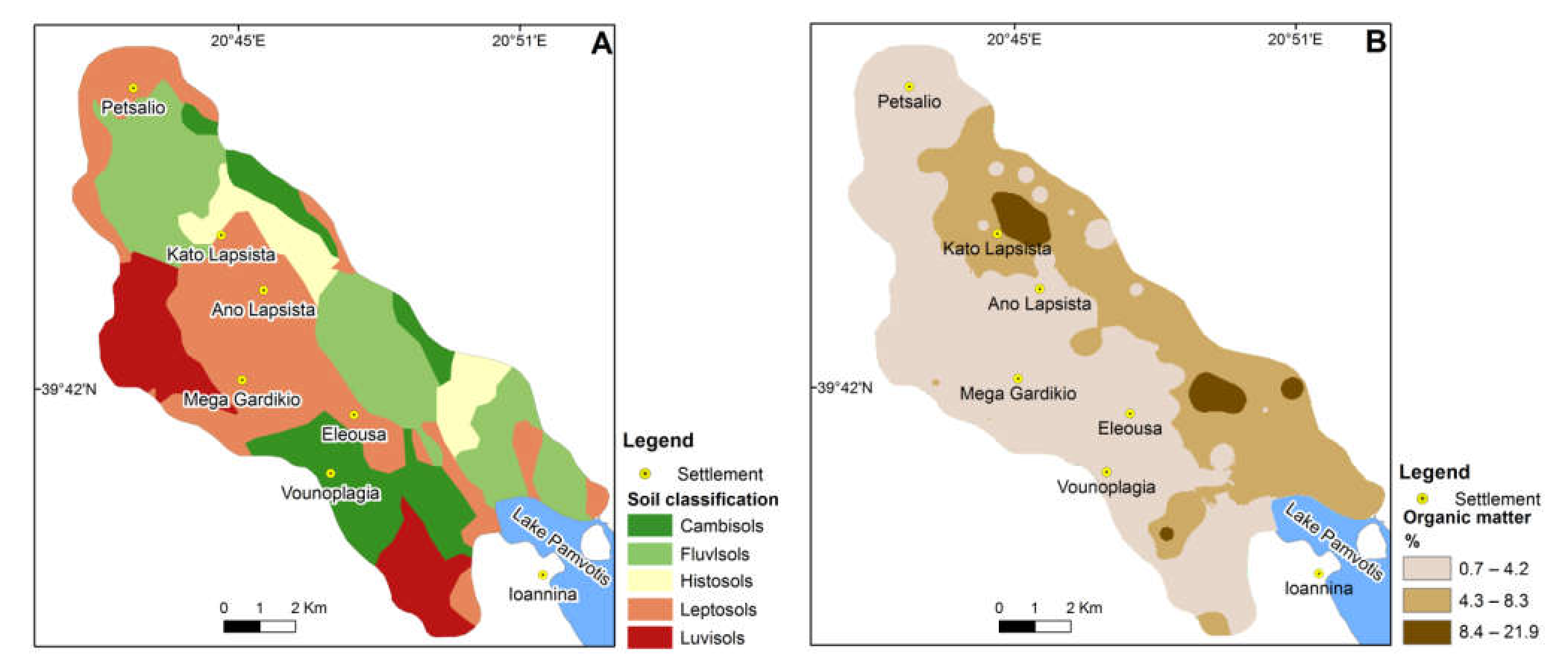
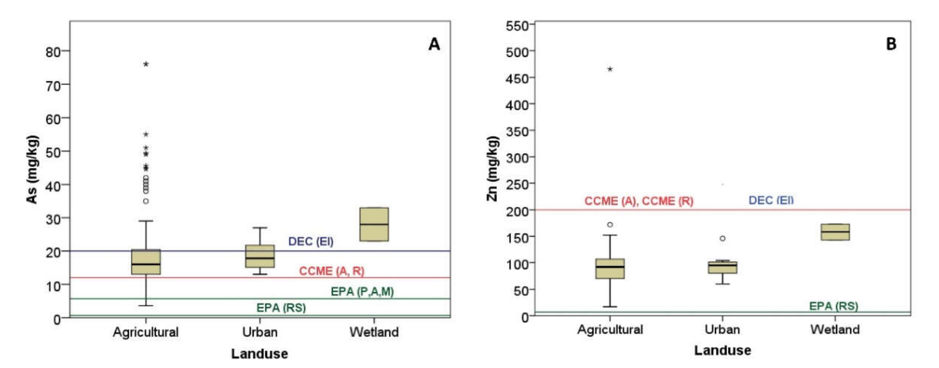
3.2. Physicochemical Characteristics of the Soil
3.3. Spatial Distribution of Elements in Soil
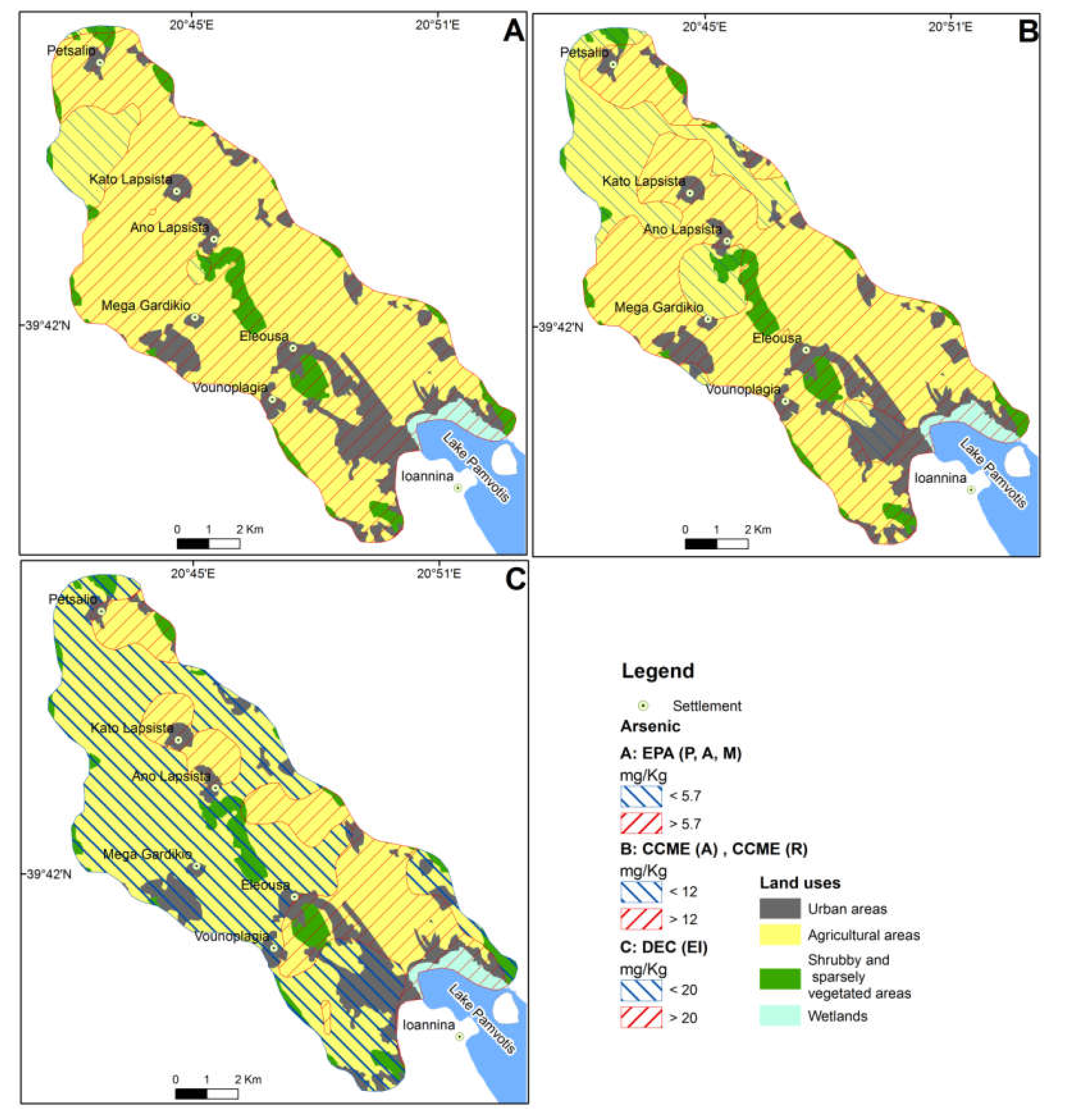
3.3.1. Arsenic
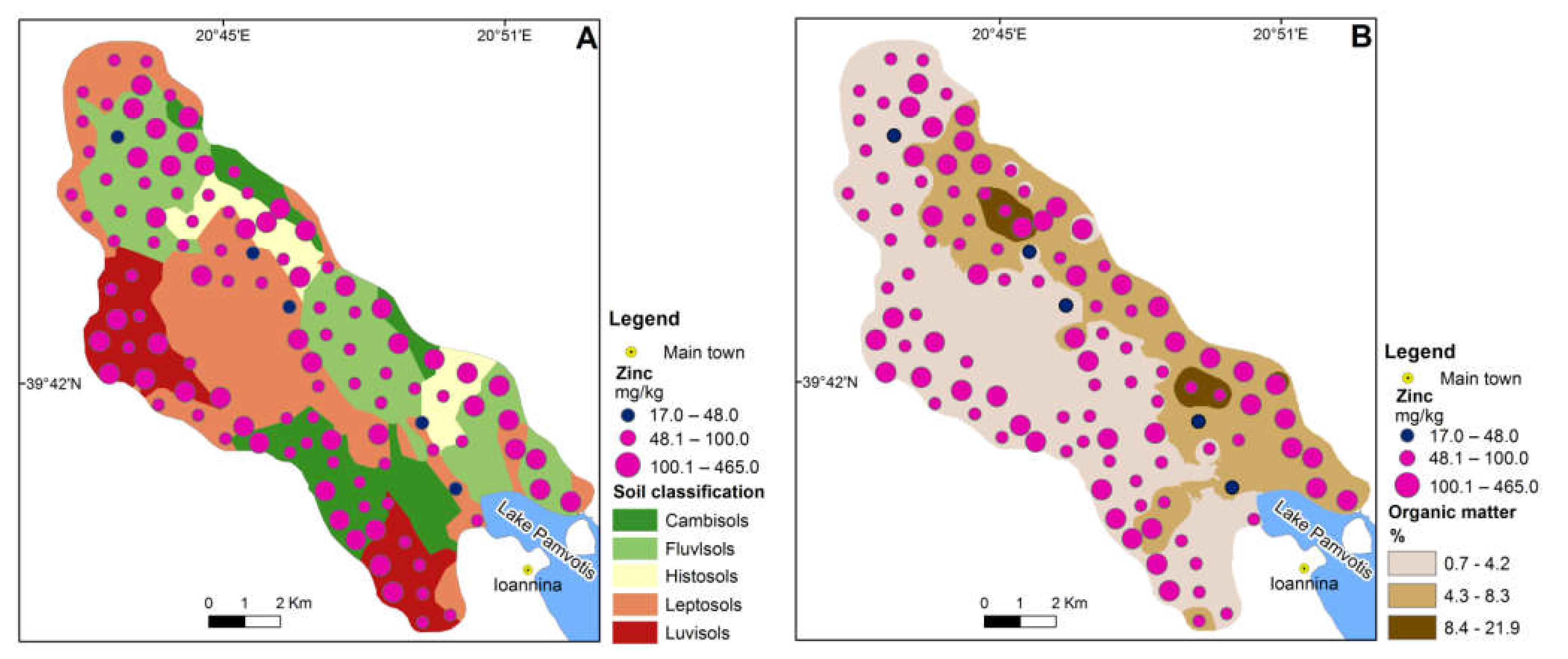
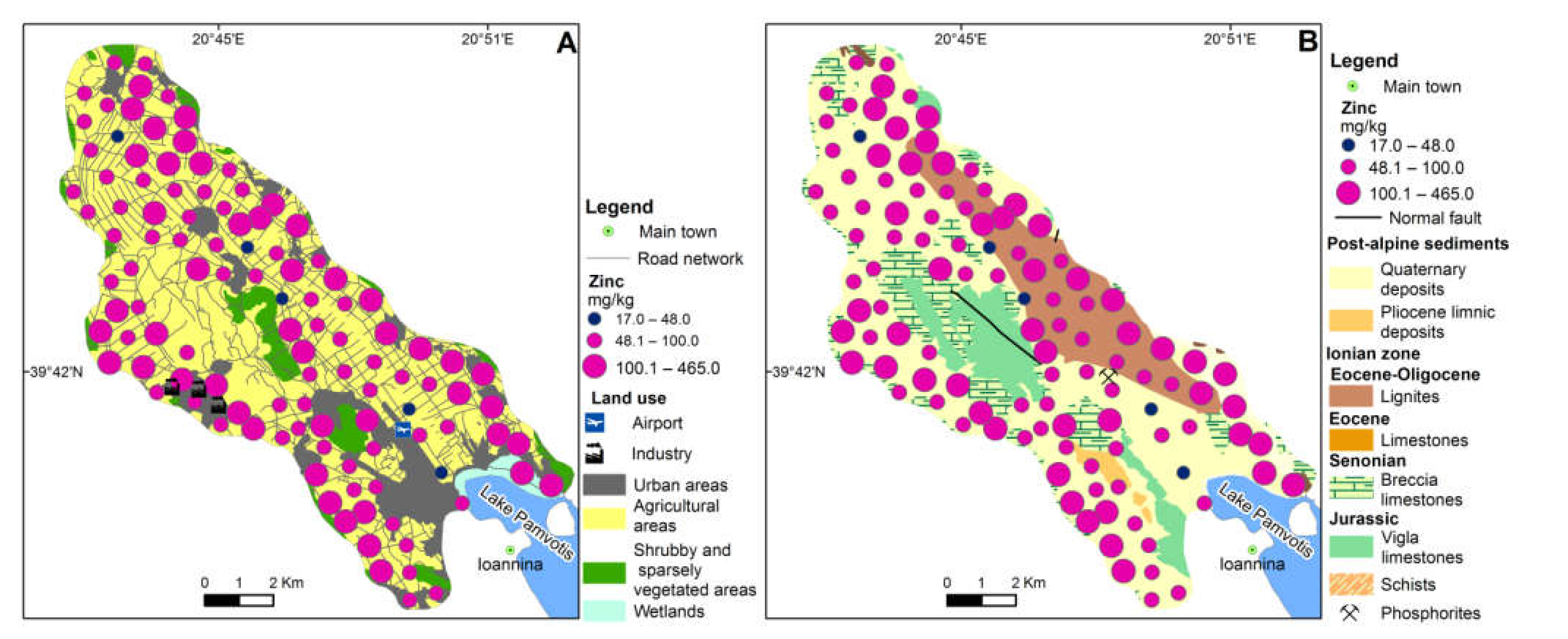
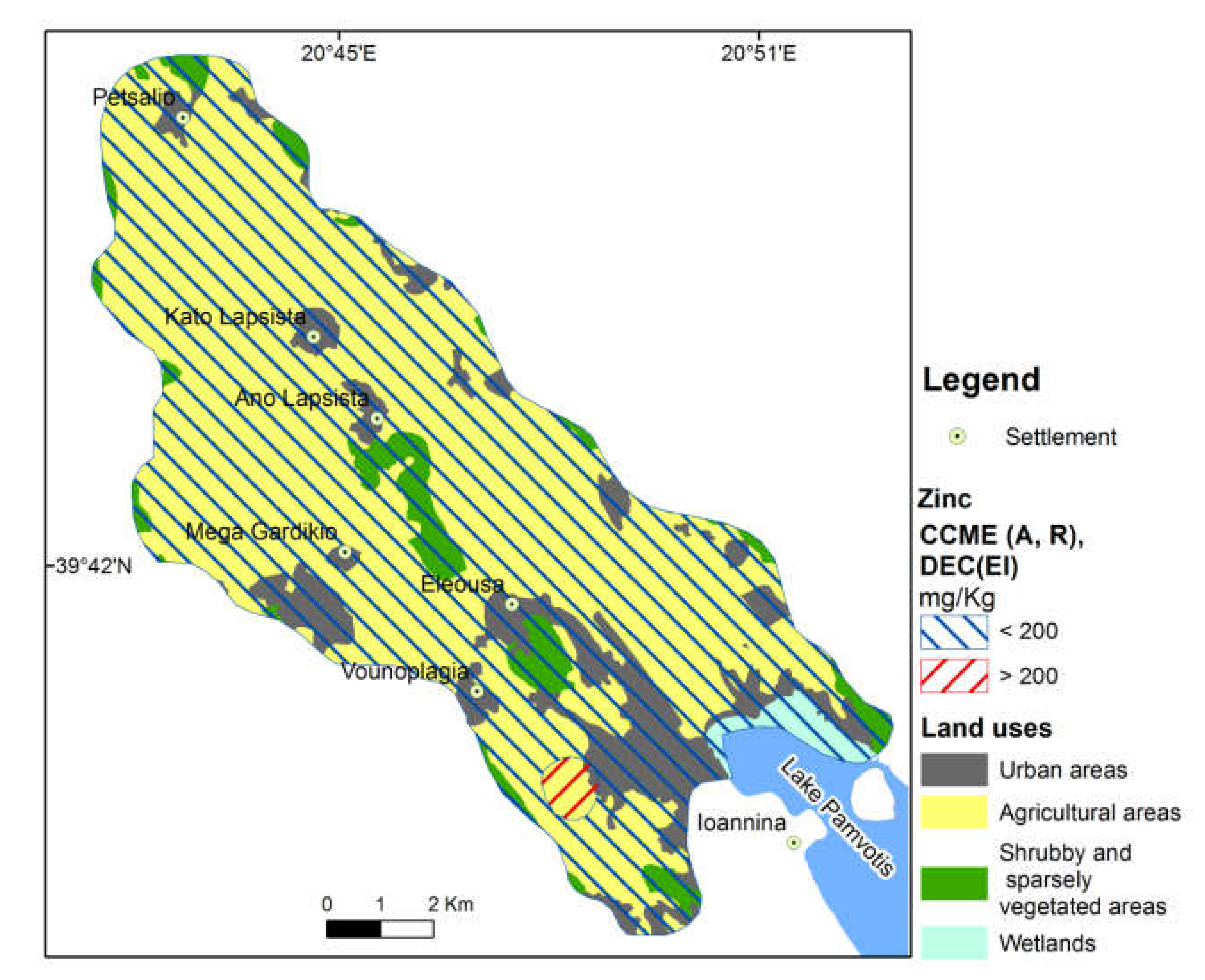
3.3.2. Zinc
4. Conclusions
Author Contributions
Funding
Institutional Review Board Statement
Informed Consent Statement
Data Availability Statement
Acknowledgments
Conflicts of Interest
References
- Ford, D.C.; Williams, P.W. Karst Hydrogeology and Geomorphology; Wiley: Chichester, UK, 2007. [Google Scholar]
- Gams, I. The polje: The problem of definition. Z. Geomorph. 1978, 55, 170–181. [Google Scholar]
- Papadopoulou-Vrynioti, K. The role of epikarst in the morphogenesis of the karstic forms in Greece and especially of the karstic hollow forms. Acta Carsolog. 2004, 33, 219–235. [Google Scholar] [CrossRef] [Green Version]
- Papadopoulou-Vrynioti, K.; Bathrellos, G.D.; Skilodimou, H.D.; Kaviris, G.; Makropoulos, K. Karst collapse susceptibility mapping considering peak ground acceleration in a rapidly growing urban area. Eng. Geol. 2013, 158, 77–88. [Google Scholar] [CrossRef]
- Bathrellos, G.D.; Skilodimou, H.D. Land use planning for natural hazards. Land 2019, 8, 128. [Google Scholar] [CrossRef] [Green Version]
- Τsolaki-Fiaka, S.; Bathrellos, G.D.; Skilodimou, H.D. Multi-criteria decision analysis for abandoned quarry restoration in Evros Region (NE Greece). Land 2018, 7, 43. [Google Scholar] [CrossRef] [Green Version]
- Skilodimou, H.D.; Bathrellos, G.D.; Koskeridou, E.; Soukis, K.; Rozos, D. Physical and anthropogenic factors related to landslide activity in the Northern Peloponnese, Greece. Land 2018, 7, 85. [Google Scholar] [CrossRef] [Green Version]
- Bathrellos, G.D.; Skilodimou, H.D.; Zygouri, V.; Koukouvelas, I.K. Landslide: A recurrent phenomenon? Landslide hazard assessment in mountainous areas of central Greece. Z. Geomorphol. 2021, 63, 95–114. [Google Scholar] [CrossRef]
- Skilodimou, H.D.; Bathrellos, G.D.; Alexakis, D.E. Flood hazard assessment mapping in burned and urban areas. Sustainability 2021, 13, 4455. [Google Scholar] [CrossRef]
- Novel, G.P.; Dimadi, A.; Zervopoulou, M.; Bakalowicz, M. The Aggitis karst system, Eastern Macedonia, Greece: Hydrologic functioning and development of the karst structure. J. Hydrol. 2007, 334, 477–492. [Google Scholar] [CrossRef]
- Gutiérrez, F.; Parise, M.; De Waele, J.; Jourde, H. A review on natural and human-induced geohazards and impacts in karst. Earth Sci. Rev. 2014, 138, 61–88. [Google Scholar] [CrossRef]
- Parise, M.; Gabrovsek, F.; Kaufmann, G.; Ravbar, N. Advances in Karst Research: Theory, Fieldwork and Applications; Geological Society of London, Special Publications: London, UK, 2018; p. 466. [Google Scholar] [CrossRef]
- Veni, G.; DuChene, H.; Crawford, C.N.; Groves, G.C.; Huppert, N.G.; Kastning, H.E.; Olson, R.; Wheeler, B. Living with Karst—A Fragile Foundation; American Geological Institute: Alexandria, VA, USA, 2001; p. 66. [Google Scholar]
- Prohic, E.; Peh, Z.; Miko, S. Geochemical characterization of a karst polje—An example from Sinjsko polje, Croatia. Environ. Geol. 1998, 33, 263–273. [Google Scholar] [CrossRef]
- Bathrellos, G.D.; Skilodimou, H.D.; Soukis, K.; Koskeridou, E. Temporal and spatial analysis of flood occurrences in drainage basin of Pinios River (Thessaly, central Greece). Land 2018, 7, 106. [Google Scholar] [CrossRef] [Green Version]
- Bathrellos, G.D.; Karymbalis, E.; Skilodimou, H.D.; Gaki-Papanastassiou, K.; Baltas, E.A. Urban flood hazard assessment in the basin of Athens Metropolitan city, Greece. Environ. Earth Sci. 2016, 75, 319. [Google Scholar] [CrossRef]
- Bathrellos, G.D.; Gaki-Papanastassiou, K.; Skilodimou, H.D.; Papanastassiou, D.; Chousianitis, K.G. Potential suitability for urban planning and industry development using natural hazard maps and geological–geomorphological parameters. Environ. Earth Sci. 2012, 66, 537–548. [Google Scholar] [CrossRef]
- Bathrellos, G.D.; Gaki-Papanastassiou, K.; Skilodimou, H.D.; Skianis, G.A.; Chousianitis, K.G. Assessment of rural community and agricultural development using geomorphological-geological factors and GIS in the Trikala prefecture (Central Greece). Stoch. Environ. Res. Risk A 2013, 27, 573–588. [Google Scholar] [CrossRef]
- Rozos, D.; Bathrellos, G.D.; Skilodimou, H.D. Comparison of the implementation of Rock Engineering System (RES) and Analytic Hierarchy Process (AHP) methods, based on landslide susceptibility maps, compiled in GIS environment. A case study from the Eastern Achaia County of Peloponnesus, Greece. Environ. Earth Sci. 2011, 63, 49–63. [Google Scholar] [CrossRef]
- Panagopoulos, G.P.; Bathrellos, G.D.; Skilodimou, H.D.; Martsouka, F.A. Mapping urban water demands using multi-criteria analysis and GIS. Water Resour. Manage. 2012, 26, 1347–1363. [Google Scholar] [CrossRef]
- Coxon, C. Agriculture and Karst. In Karst Management; Van Beynen, P., Ed.; Springer: Cham, Switzerland, 2011; pp. 103–113. [Google Scholar] [CrossRef]
- Papadopoulou-Vrynioti, K.; Alexakis, D.; Bathrellos, G.; Skilodimou, H.; Vryniotis, D.; Vassiliades, E.; Gamvroula, D. Distribution of trace elements in stream sediments of Arta plain (western Hellas): The influence of geomorphological parameters. J. Geochem. Explor. 2013, 134, 17–26. [Google Scholar] [CrossRef]
- Papadopoulou, K.; Vryniotis, D. Quality of soil and water in deltaic deposits of Louros and Arachthos rivers related to karstic rocks of the wider area. Bull. Geol. Soc. Greece 2007, 40, 1599–1608. [Google Scholar] [CrossRef] [Green Version]
- Kazakis, N.; Chalikakis, K.; Mazzilli, N.; Ollivier, C.; Manakos, A.; Voudouris, K. Management and research strategies of karst aquifers in Greece: Literature overview and exemplification based on hydrodynamic modelling and vulnerability assessment of a strategic karst aquifer. Sci. Total Environ. 2017, 643, 592–609. [Google Scholar] [CrossRef] [PubMed]
- Green, R.T.; Painter, S.L.; Sun, A.; Worthington, S.R. Groundwater contamination in karst terranes. Water Air Soil Pollut. Focus 2006, 6, 157–170. [Google Scholar] [CrossRef]
- Alexakis, D.; Tsakiris, G. Drought impacts on karstic spring annual water potential. Application on Almyros (Heraklion Crete) brackish spring. Desalin. Water Treat. 2010, 16, 1–9. [Google Scholar] [CrossRef] [Green Version]
- Tsakiris, G.; Alexakis, D. Karstic spring water quality: The effect of groundwater abstraction from the recharge area. Desalin. Water Treat. 2014, 52, 2494–2501. [Google Scholar] [CrossRef]
- Papadopoulou-Vrynioti, K.; Alexakis, D.; Bathrellos, G.; Skilodimou, H.; Vryniotis, D.; Vassiliades, E. Environmental research and evaluation of agricultural soil of the Arta plain, western Hellas. J. Geochem. Explor. 2014, 136, 84–92. [Google Scholar] [CrossRef]
- Alexakis, D. Human health risk assessment associated with Co, Cr, Mn, Ni and V contents in agricultural soils from a Mediterranean site. Arch. Agron. Soil Sci. 2016, 62, 359–373. [Google Scholar] [CrossRef]
- Alexakis, D. Suburban areas in flames: Dispersion of potentially toxic elements from burned vegetation and buildings. Estimation of the associated ecological and human health risk. Environ. Res. 2020, 183, 109153. [Google Scholar] [CrossRef]
- Alexakis, D. Contaminated land by wildfire effect on ultramafic soil and associated human health and ecological risk. Land 2020, 9, 409. [Google Scholar] [CrossRef]
- Alexakis, D.; Gotsis, D.; Giakoumakis, S. Assessment of drainage water quality in pre- and post-irrigation seasons for supplemental irrigation use. Environ. Monit. Assess. 2012, 184, 5051–5063. [Google Scholar] [CrossRef] [PubMed]
- Alexakis, D.; Gotsis, D.; Giakoumakis, S. Evaluation of soil salinization in a Mediterranean site (Agoulinitsa district—West Greece). Arab. J. Geosci. 2014, 8, 1373–1383. [Google Scholar] [CrossRef]
- Kelepertsis, A.; Alexakis, D.; Kita, I. Environmental geochemistry of soils and waters of Susaki area, Korinthos, Greece. Environ. Geochem. Health 2001, 23, 117–135. [Google Scholar] [CrossRef]
- Kelepertsis, A.; Alexakis, D. The impact of mining and metallurgical activity of the Lavrion sulfide deposits on the geochemistry of bottom sea sediments East of the Lavreotiki Peninsula, Greece. Res. J. Chem. Environ. 2004, 8, 40–46. [Google Scholar]
- Bathrellos, G.D.; Skilodimou, H.D.; Kelepertsis, A.; Alexakis, D.; Chrisanthaki, I.; Archonti, D. Environmental research of groundwater in the urban and suburban areas of Attica region, Greece. Environ. Geol. 2008, 56, 11–18. [Google Scholar] [CrossRef]
- Gamvroula, D.; Alexakis, D.; Stamatis, G. Diagnosis of groundwater quality and assessment of contamination sources in the Megara basin (Attica, Greece). Arab. J. Geosci. 2013, 6, 2367–2381. [Google Scholar] [CrossRef]
- Makri, P.; Stathopoulou, E.; Hermides, D.; Kontakiotis, G.; Zarkogiannis, S.D.; Skilodimou, H.D.; Scoullos, M. The Environmental Impact of a Complex Hydrogeological System on Hydrocarbon-Pollutants’ Natural Attenuation: The Case of the Coastal Aquifers in Eleusis, West Attica, Greece. J. Mar. Sci. Eng. 2020, 8, 1018. [Google Scholar] [CrossRef]
- Alexakis, D. Diagnosis of stream sediment quality and assessment of toxic element contamination sources in East Attica, Greece. Environ. Earth Sci. 2011, 63, 1369–1383. [Google Scholar] [CrossRef]
- Ivezić, V.; Singh, B.R.; Almås, A.R.; Lončarić, Z. Water extractable concentrations of Fe, Mn, Ni, Co, Mo, Pb and Cd under different land uses of Danube basin in Croatia. Acta Agriculturae Scandinavica. Sect. B Soil Plant Sci. 2011, 61, 747–759. [Google Scholar]
- Abbaslou, H.; Martin, F.; Abtahi, A.; Moore, F. Trace element concentrations and background values in the arid soils of Hormozgan Province of southern Iran. Arch. Agron. Soil Sci. 2014, 60, 1125–1143. [Google Scholar] [CrossRef]
- Kabata-Pendias, A.; Mukherjee, A.B. Trace Elements from Soil to Human; Springer: Berlin/Heidelberg, Germany, 2007. [Google Scholar]
- Mendyk, Ł.; Hulisz, P.; Świtoniak, M.; Kalisz, B.; Spychalski, W. Human activity in the surroundings of a former mill pond (Turznice, N Poland): Implications for soil classification and environmental hazard assessment. Soil Sci. Ann. 2020, 71, 371–381. [Google Scholar] [CrossRef]
- Uzarowicz, Ł.; Charzyński, P.; Greinert, A.; Hulisz, P.; Kabała, C.; Kusza, G.; Pędziwiatr, A. Studies of technogenic soils in Poland: Past, present, and future perspectives. Soil Sci. Ann. 2020, 71, 281–299. [Google Scholar] [CrossRef]
- Gruszecka-Kosowska, A.; Kicińska, A. Long-Term Metal-Content Changes in Soils on the Olkusz Zn–Pb Ore-Bearing Area, Poland. Int. J. Environ. Res. 2017, 11, 359–376. [Google Scholar] [CrossRef] [Green Version]
- Alexakis, D.; Gamvroula, D.; Theofili, E. Environmental availability of potentially toxic elements in an agricultural Mediterranean site. Environ. Eng. Geosci. 2019, 25, 169–178. [Google Scholar] [CrossRef]
- IGME. Geological Maps of Greece, Sheet Ioannina, Scale 1:50,000; Institute of Geology and Mineral Exploration: Thessaloniki, Greece, 1967. [Google Scholar]
- IGME. Geological Maps of Greece, Sheet Klimatia, Scale 1:50,000; Institute of Geology and Mineral Exploration: Thessaloniki, Greece, 1968. [Google Scholar]
- IGME. Geological Maps of Greece, Sheet Doliana, Scale 1:50,000; Institute of Geology and Mineral Exploration: Thessaloniki, Greece, 1968. [Google Scholar]
- IGME. Geological Maps of Greece, Sheet Tselepovo, Scale 1:50,000; Institute of Geology and Mineral Exploration: Thessaloniki, Greece, 1970. [Google Scholar]
- Copernicus. Urban Atlas 2018. Copernicus Land Monitoring Service. 2021. Available online: https://land.copernicus.eu/local/urban-atlas/urban-atlas-2018 (accessed on 7 May 2021).
- (Payment and Control Agency for Guidance and Guarantee Community Aid. Soil Map of Greece (Scale 1:500,000) Project Framework: Development of an Integrated System for Soil Geographic Data and Delineation of Agricultural Zones in Greece. Scientific Coordinator N. Misopollinos. Available online: https://esdac.jrc.ec.europa.eu/public_path/shared_folder/maps/eudasm_newmaps/GR/GRSoilMap_ENG.jpg (accessed on 7 May 2021).
- Hellenic Civil Aviation Authority (HCAA). 2021. Available online: http://www.hcaa.gr/en/our-airports/kratikos-aerolimenas-iwanninwn-basileys-pyrros-kaiwp (accessed on 20 March 2021).
- Gentzis, T.; Goodarzi, F.; Foscolos, A. Geochemistry and mineralogy of Greek lignites from the Ioannina basin. Energy Sources 1997, 19, 111–128. [Google Scholar] [CrossRef]
- Karakitsios, V. Western Greece and Ionian Sea petroleum systems. AAPG Bull. 2013, 97, 1567–1595. [Google Scholar] [CrossRef] [Green Version]
- Bathrellos, G.D.; Skilodimou, H.D.; Maroukian, H. The spatial distribution of Middle and Late Pleistocene cirques in Greece. Geogr. Ann. A 2014, 96, 323–338. [Google Scholar] [CrossRef]
- Bathrellos, G.D.; Skilodimou, H.D.; Maroukian, H.; Gaki-Papanastassiou, K.; Kouli, K.; Tsourou, T.; Tsaparas, N. Pleistocene glacial and lacustrine activity in the southern part of Mount Olympus (central Greece). Area 2017, 49, 137–147. [Google Scholar] [CrossRef]
- Bathrellos, G.D.; Skilodimou, H.D.; Maroukian, H. The significance of tectonism in the glaciations of Greece. Geol. Soc. SP. 2017, 433, 237–250. [Google Scholar] [CrossRef]
- Roucoux, K.H.; Tzedakis, P.C.; Lawson, I.T.; Margari, V. Vegetation history of the penultimate glacial period (MIS 6) at Ioannina, northwest Greece. J. Quat. Sci. 2011, 26, 616–626. [Google Scholar] [CrossRef]
- Bouyoucos, G.J. Hydrometer method improved for making particle size analysis of soils. Agron. J. 1962, 54, 464–465. [Google Scholar] [CrossRef]
- Soil Survey Staff. Soil Survey Staff. Soil Survey Laboratory Methods Manual, Version No.4.0. USDA NRCS. In Soil Survey Investigations Report 2004; U.S. Govternment Print Office: Washington, DC, USA, 2004. [Google Scholar]
- Iñigo, V.; Marín, A.; Andrades, M.; Jiménez-Ballesta, R. Evaluation of the copper and zinc contents of soils in the vineyards of La Rioja (Spain). Environments 2020, 7, 55. [Google Scholar] [CrossRef]
- De Vos, B.; Lettens, S.; Muys, B.; Deckers, J.A. Walkley–Black analysis of forest soil organic carbon: Recovery, limitations and uncertainty. Soil Use Manag. 2007, 23, 221–229. [Google Scholar] [CrossRef]
- Salminen, R.; Batista, M.J.; Bidovec, M.; Demetriades, A.; De Vivo, B.; De Vos, W.; Tarvainen, T.; Geochemical Atlas of Europe. Part 1–Background Information, Methodology and Maps. Geological Survey of Finland, Espoo, Finland. 2005. Available online: http://weppi.gtk.fi/publ/foregsatlas (accessed on 17 March 2021).
- EPA (Environmental Protection Agency) Cleanup Regulations and Standards. Available online: http://www.epa.gov/cleanup/regs.htm (accessed on 20 March 2021).
- CCME (Canadian Council of Ministers of the Environment). Available online: http://st-ts.ccme.ca (accessed on 20 March 2021).
- DEC (Department of Environment and Conservation). Contaminated Sites Management Series: Assessment Levels for Soil, Sediment and Water. 2010. Available online: http://www.dec.wa.gov.au/contaminatedsites (accessed on 20 March 2021).
- Papadopoulou-Vrynioti, K.; Mertzanis, A.; Vryniotis, D.; Vassiliades, E.; Karakitsios, V. The contribution of karstic rocks to soil quality, Ioannina plain (Epirus, Hellas). J. Geochem. Explor. 2015, 154, 224–237. [Google Scholar] [CrossRef]
- Migiros, G.; Bathrellos, G.D.; Skilodimou, H.D.; Karamousalis, T. Pinios (Peneus) River (Central Greece): Hydrological—Geomorphological elements and changes during the Quaternary. Cent. Eur. J. Geosci. 2011, 3, 215–228. [Google Scholar] [CrossRef]
- Kamberis, E.; Bathrellos, G.; Kokinou, E.; Skilodimou, H. Correlation between the structural pattern and the development of the hydrographic network in a portion of the Western Thessaly basin (Greece). Cent. Eur. J. Geosci. 2012, 4, 416–424. [Google Scholar] [CrossRef] [Green Version]
- Kokinou, E.; Skilodimou, H.D.; Bathrellos, G.D.; Antonarakou, A.; Kamberis, E. Morphotectonic analysis, structural evolution/pattern of a contractional ridge: Giouchtas Mt., Central Crete, Greece. J. Earth Syst. Sci. 2015, 124, 587–602. [Google Scholar]
- Rozos, D.; Skilodimou, H.D.; Loupasakis, C.; Bathrellos, G.D. Application of the revised universal soil loss equation model on landslide prevention. An example from N. Euboea (Evia) Island, Greece. Environ. Earth Sci. 2013, 70, 3255–3266. [Google Scholar] [CrossRef]
- Skilodimou, H.D.; Livaditis, G.; Bathrellos, G.D.; Verikiou-Papaspiridakou, E. Investigating the flooding events of the urban regions of Glyfada and Voula, Attica, Greece: A contribution to Urban Geomorphology. Geogr. Ann. A 2003, 85, 197–204. [Google Scholar] [CrossRef]
- Skilodimou, H.D.; Bathrellos, G.D.; Maroukian, H.; Gaki-Papanastassiou, K. Late Quaternary evolution of the lower reaches of Ziliana stream in south Mt. Olympus (Greece). Geogr. Fis. Din. Quat. 2014, 37, 43–50. [Google Scholar]
- Bathrellos, G.D.; Skilodimou, H.D.; Chousianitis, K.; Youssef, A.M.; Pradhan, B. Suitability estimation for urban development using multi-hazard assessment map. Sci. Total Environ. 2017, 575, 119–134. [Google Scholar] [CrossRef]
- Bathrellos, G.D.; Kalivas, D.P.; Skilodimou, H.D. Landslide Susceptibility Assessment Mapping: A Case Study in Central Greece. In Remote Sensing of Hydrometeorological Hazards; Petropoulos, G.P., Islam, T., Eds.; CRC Press; Taylor & Francis Group: London, UK, 2017; pp. 493–512. [Google Scholar]
- Youssef, A.M.; Pradhan, B.; Al-Kathery, M.; Bathrellos, G.D.; Skilodimou, H.D. Assessment of rockfall hazard at Al-Noor Mountain, Makkah city (Saudi Arabia) using spatio-temporal remote sensing data and field investigation. J. Afr. Earth Sci. 2015, 101, 309–321. [Google Scholar] [CrossRef]
- Chousianitis, K.; Del Gaudio, V.; Sabatakakis, N.; Kavoura, K.; Drakatos, G.; Bathrellos, G.D.; Skilodimou, H.D. Assessment of Earthquake-Induced Landslide Hazard in Greece: From Arias Intensity to Spatial Distribution of Slope Resistance Demand. B. Seismol. Soc. Am. 2016, 106, 174–188. [Google Scholar] [CrossRef]
- Skilodimou, H.D.; Bathrellos, G.D.; Chousianitis, K.; Youssef, A.M.; Pradhan, B. Multi-hazard assessment modeling via multi-criteria analysis and GIS: A case study. Environ. Earth Sci. 2019, 78, 47. [Google Scholar] [CrossRef]
- Li, G.; Lu, N.; Wei, Y.; Zhu, D. Relationship between heavy metal content in polluted soil and soil organic matter and pH in mining areas. IOP Conf. Ser. Mater. Sci. Eng. 2018, 394, 052081. [Google Scholar] [CrossRef]
- Kabata-Pendias, A.; Pendias, H. Trace Elements in Soils and Plants; CRC Press Inc: Boca Raton, FL, USA, 1995. [Google Scholar]
- Alexakis, D.; Gamvroula, D. Arsenic, chromium, and other potentially toxic elements in the rocks and sediments of Oropos-Kalamos basin, Attica, Greece. Appl. Environ. Soil Sci. 2014, 2014, 718534. [Google Scholar] [CrossRef] [Green Version]
- Stamatis, G.; Alexakis, D.; Gamvroula, D.; Migiros, G. Groundwater quality assessment in Oropos-Kalamos basin, Attica, Greece. Environ. Earth Sci. 2011, 64, 973–988. [Google Scholar] [CrossRef]
- Golfinopoulos, S.; Varnavas, S.; Alexakis, D. The status of arsenic pollution on the Greek and Cyprus environment: An Overview. Water 2021, 13, 224. [Google Scholar] [CrossRef]
- Amato, F.; Moreno, T.; Pandolfi, M.; Querol, X.; Alastuey, A.; Delgado, A.; Pedrero, M.; Cots, N. Concentrations, sources and geochemistry of airborne particulate matter at a major European airport. J. Environ. Monit. 2010, 12, 854–862. [Google Scholar] [CrossRef] [Green Version]
- Agrawal, H.; Sawanta, A.; Jansen, K.; Miller, J.W.; Cocker, D.R. Characterization of chemical and particulate emissions from aircraft engines. Atmos. Environ. 2008, 42, 4380–4392. [Google Scholar] [CrossRef]
- Dousova, B.; Lhotka, M.; Buzek, F.; Cejkova, B.; Jackova, I.; Bednar, V.; Hajek, P. Environmental interaction of antimony and arsenic near busy traffic nodes. Sci. Total Environ. 2020, 702, 134642. [Google Scholar] [CrossRef]
- Wiseman, C.L.S.; Zereini, F.; Püttmann, W. Traffic-related trace element fate and uptake by plants cultivated in roadside soils in Toronto, Canada. Sci. Total Environ. 2013, 442, 86–95. [Google Scholar] [CrossRef]
- Bergqvist, C.; Herbert, R.; Persson, I.; Greger, M. Plants influence on arsenic availability and speciation in the rhizosphere, roots and shoots of three different vegetables. Environ. Pollut. 2014, 184, 540–546. [Google Scholar] [CrossRef]
- Schroeder, H.A.; Balassa, J.J. Abnormal trace metals in man. Cadmium. J. Chronic Dis. 1961, 14, 236–258. [Google Scholar] [CrossRef]
- Rahman, A.; Kumarathasan, P.; Gomes, J. Infant and mother related outcomes from exposure to metals with endocrine disrupting properties during pregnancy. Sci. Total Environ. 2016, 56, 1022–1031. [Google Scholar] [CrossRef]
- Vryniotis, D. Soil Geochemical—Environmental Survey of the N.W. Part of the Ioannina Basin; I.G.M.E. Open File Report: Athens, Greece, 2010; p. 95. [Google Scholar]
- Boyle, K.A. Evaluating particulate emissions from jet engines: Analysis of chemical and physical characteristics and potential impacts on coastal environments and human health. Transport. Res. J. Transp. Res. Board 1996, 1517, 1–9. [Google Scholar] [CrossRef]
- Nunes, L.M.; Stigter, T.Y.; Teixeira, M.R. Environmental impacts on soil and groundwater at airports: Origin, contaminants of concern and environmental risks. J. Environ. Monit. 2011, 13, 3026–3039. [Google Scholar] [CrossRef] [PubMed]
- Adamiec, E.; Jarosz-Krzeminska, E.; Wieszała, R. Heavy metals from non-exhaust vehicle emissions in urban and motorway road dusts. Environ. Monit. Assess. 2016, 188, 369. [Google Scholar] [CrossRef] [Green Version]
- Apeagyei, E.; Bank, M.S.; Spengler, J.D. Distribution of heavy metals in road dust along an urban-rural gradient in Massachusetts. Atmos. Environ. 2011, 45, 2310–2323. [Google Scholar] [CrossRef]
- Aravelli, K.; Heibel, A. Improved lifetime pressure drop management for robust cordierite (RC) filters with asymmetric cell technology (ACT). SAE Tech. Paper Series 2007, 1, 920. [Google Scholar] [CrossRef]
- Spikes, H. Low—And zero-sulphated ash, phosphorus and sulphur anti-wear additives for engine oils. Lubric. Sci. 2008, 20, 103–136. [Google Scholar] [CrossRef]
- Alexakis, D. Multielement contamination of land in the margin of highways. Land 2021, 10, 230. [Google Scholar] [CrossRef]
- Jaradat, Q.M.; Masadeh, A.; Zaitoun, M.; Maitah, B. Heavy metal contamination of soil, plant and air of scrapyard of discarded vehicles at Zarqa city, Jordan. Soil Sediment Contam. Int. J. 2005, 14, 449–462. [Google Scholar] [CrossRef]
- Doncheva, S.; Stoynova, Z.; Velikova, V. Influence of succinate on zinc toxicity of pea plants. J. Plant Nutr. 2001, 24, 789–804. [Google Scholar] [CrossRef]
- Duruibe, J.O.; Ogwuegbu, M.O.C.; Egwurugwu, J.N. Heavy metal pollution and human biotoxic effects. Int. J. Phys. Sci. 2007, 2, 112–118. [Google Scholar]
- Fosmire, G.J. Zinc toxicity. Am. J. Clin Nutr. 1990, 51, 225–227. [Google Scholar] [CrossRef] [PubMed]


| Organic Matter | Clay | Silt | Sand | |
|---|---|---|---|---|
| Agricultural land use (n = 102) | ||||
| Mean | 4.2 | 32.3 | 38.1 | 29.8 |
| Median | 3.3 | 31.0 | 38.5 | 27.0 |
| Minimum | 0.7 | 5.0 | 13.0 | 4.0 |
| Maximum | 22.0 | 64.0 | 64.0 | 82.0 |
| Urban land use (n = 8) | ||||
| Mean | 4.1 | 35.9 | 36.5 | 27.8 |
| Median | 3.6 | 31.5 | 37.5 | 23.5 |
| Minimum | 1.0 | 11.0 | 20.0 | 7.0 |
| Maximum | 6.9 | 65.0 | 56.0 | 69.0 |
| Wetlands (n = 2) | ||||
| Minimum | 4.4 | 42.0 | 31.0 | 12.0 |
| Maximum | 6.8 | 57.0 | 35.0 | 23.0 |
| As | Zn | |
|---|---|---|
| Detection limit | 2 | 2 |
| Agricultural land use (n = 102) | ||
| Mean | 19.8 | 94.6 |
| Median | 16.0 | 92.0 |
| Minimum | 3.6 | 17.0 |
| Maximum | 76.0 | 465.0 |
| Urban land use (n = 8) | ||
| Mean | 18.7 | 94.9 |
| Median | 17.8 | 95.0 |
| Minimum | 13.0 | 60.0 |
| Maximum | 27.0 | 146.0 |
| Wetlands (n = 2) | ||
| Minimum | 23.0 | 143.0 |
| Maximum | 33.0 | 173.0 |
| European topsoil [65] | 6.0 | 48.0 |
| EPA Residential soil [66] | 0.68 | 2300 |
| EPA Plant-Avian-Mammalian [66] | 5.7 | 6.62 |
| CCME Agricultural land use [67] | 12 | 200 |
| CCME Residential land use [67] | 12 | 200 |
| DEC Ecological Investigation level [68] | 20 | 200 |
| As | Zn | OM | Clay | Sand | Silt | ||
|---|---|---|---|---|---|---|---|
| As | r | 1.00 | −0.10 | 0.27 | −0.03 | 0.10 | −0.13 |
| p-value | 0.317 | 0.004 | 0.774 | 0.309 | 0.166 | ||
| Zn | r | 1.00 | 0.24 | 0.17 | −0.18 | 0.09 | |
| p-value | 0.010 | 0.082 | 0.065 | 0.323 | |||
| OM | r | 1.00 | −0.12 | 0.11 | −0.04 | ||
| p-value | 0.197 | 0.249 | 0.710 | ||||
| Clay | r | 1.00 | −0.82 | 0.16 | |||
| p-value | 0.000 | 0.104 | |||||
| Sand | r | 1.00 | −0.70 | ||||
| p-value | 0.000 | ||||||
| Silt | r | 1.00 |
Publisher’s Note: MDPI stays neutral with regard to jurisdictional claims in published maps and institutional affiliations. |
© 2021 by the authors. Licensee MDPI, Basel, Switzerland. This article is an open access article distributed under the terms and conditions of the Creative Commons Attribution (CC BY) license (https://creativecommons.org/licenses/by/4.0/).
Share and Cite
Alexakis, D.E.; Bathrellos, G.D.; Skilodimou, H.D.; Gamvroula, D.E. Spatial Distribution and Evaluation of Arsenic and Zinc Content in the Soil of a Karst Landscape. Sustainability 2021, 13, 6976. https://0-doi-org.brum.beds.ac.uk/10.3390/su13126976
Alexakis DE, Bathrellos GD, Skilodimou HD, Gamvroula DE. Spatial Distribution and Evaluation of Arsenic and Zinc Content in the Soil of a Karst Landscape. Sustainability. 2021; 13(12):6976. https://0-doi-org.brum.beds.ac.uk/10.3390/su13126976
Chicago/Turabian StyleAlexakis, Dimitrios E., George D. Bathrellos, Hariklia D. Skilodimou, and Dimitra E. Gamvroula. 2021. "Spatial Distribution and Evaluation of Arsenic and Zinc Content in the Soil of a Karst Landscape" Sustainability 13, no. 12: 6976. https://0-doi-org.brum.beds.ac.uk/10.3390/su13126976