
The History and Driving Force for Prehistoric Human Expansion Upward to the Hinterland of the Tibetan Plateau Post–Last Glacial Maximum


Abstract
:1. Introduction
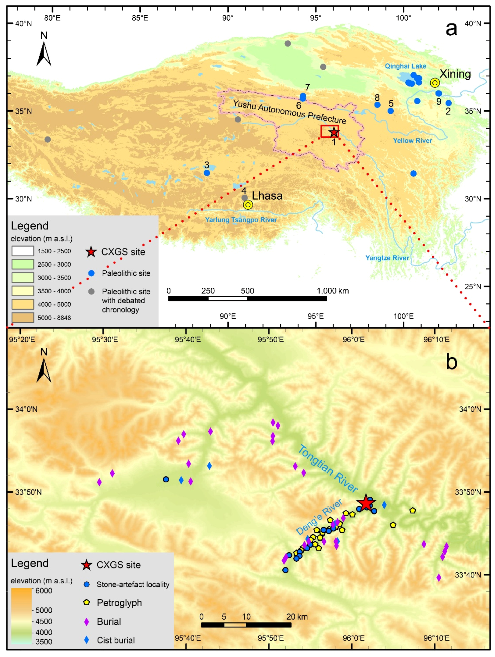
2. Study Area
3. Materials and Methods
4. Results
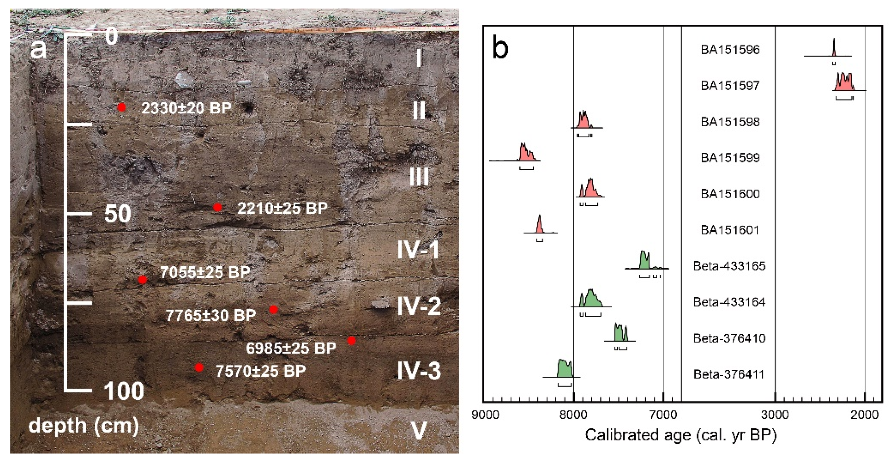
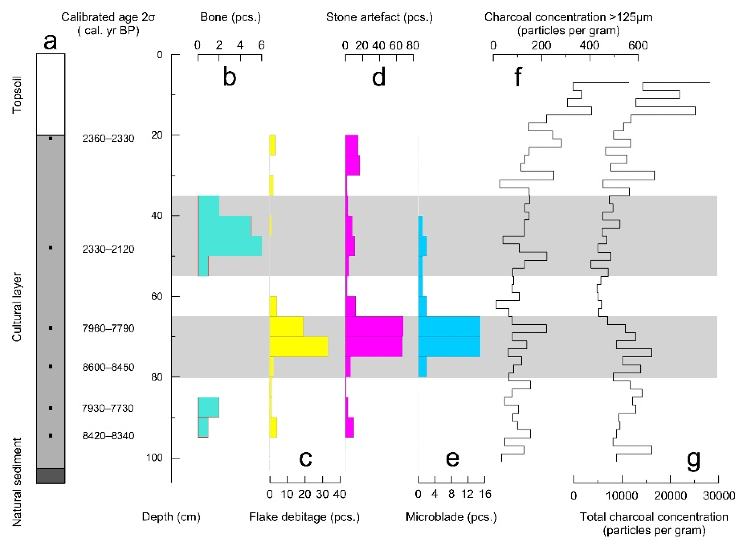
4.1. Chronology
4.2. Indicators of Human Activity
4.3. Variation of Charcoal Concentration
5. Discussion
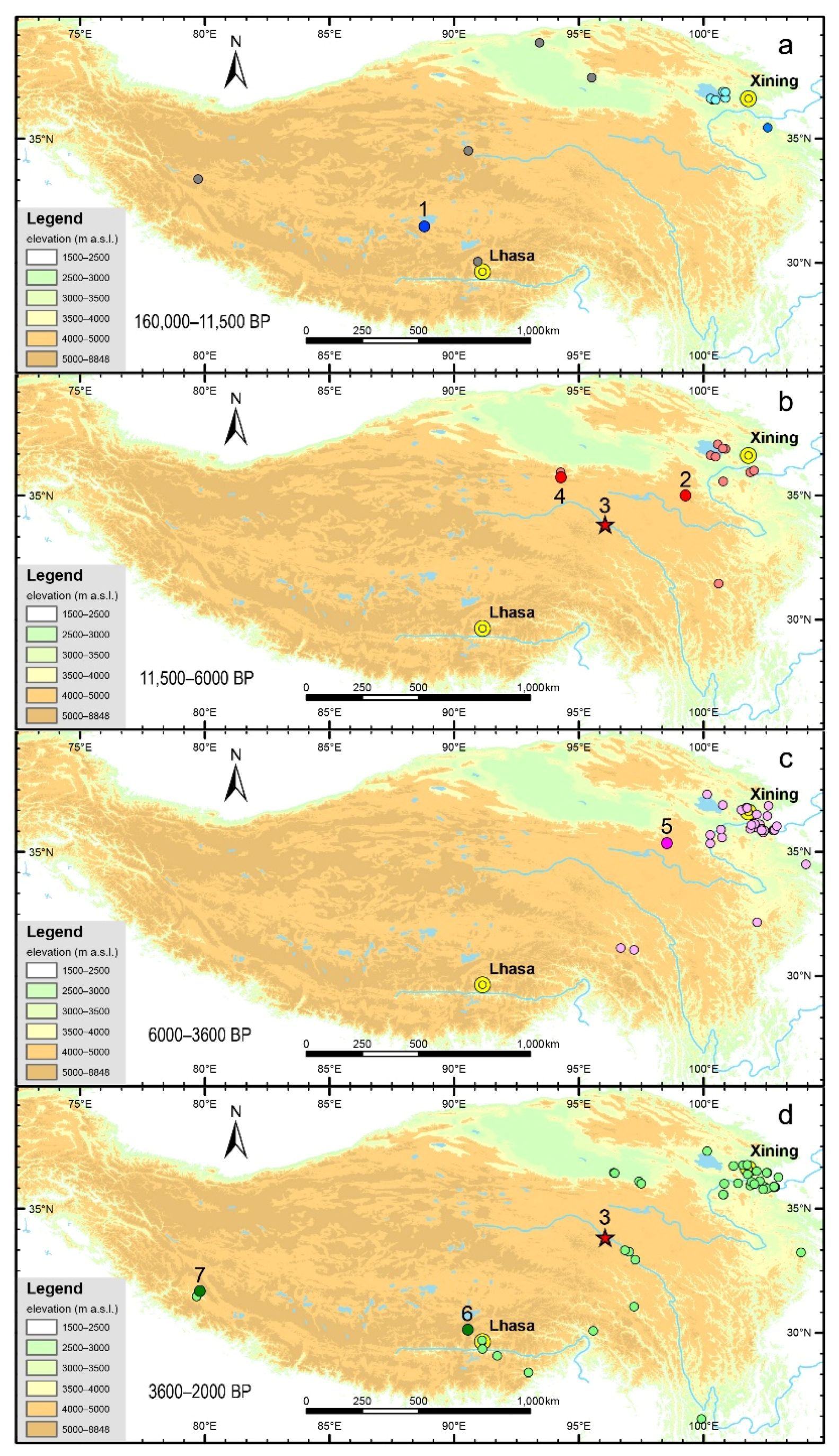
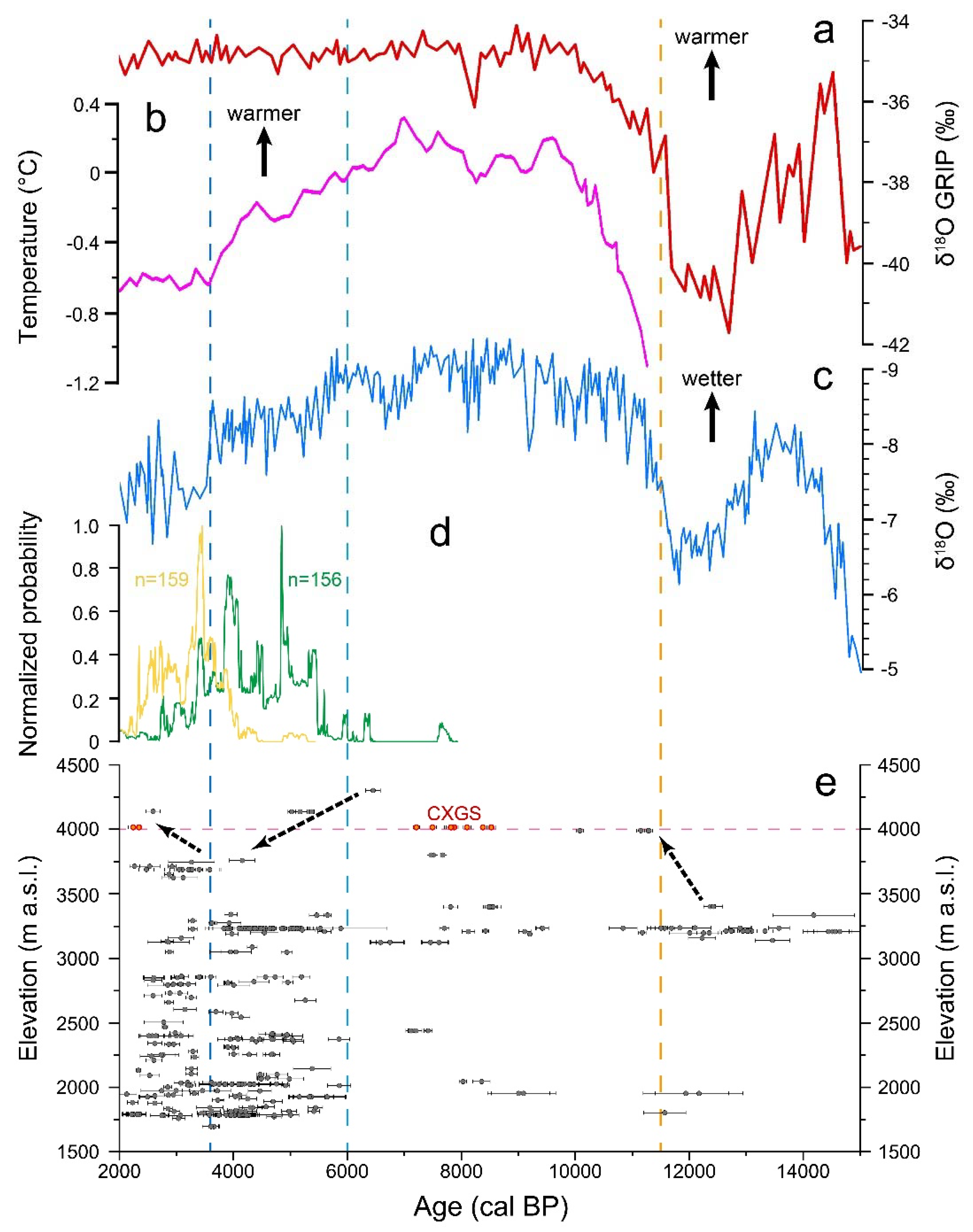
5.1. History for Prehistoric Human Expansion upward to the Hinterland of Tibetan Plateau
5.2. The Factors Promoted Prehistoric Human Expansion upward into the Hinterland of the Tibetan Plateau Post–Last Glacial Maximum (LGM)
6. Conclusions
Supplementary Materials
Author Contributions
Funding
Data Availability Statement
Acknowledgments
Conflicts of Interest
References
- Wu, T.Y. Challenge of plateau hypoxia environment to human being. J. Med. Res. 2006, 35, 1–2. (In Chinese) [Google Scholar]
- Madsen, D.B.; Ma, H.Z.; Brantingham, P.J.; Gao, X.; Rhode, D.; Zhang, H.Y.; Olsen, J.W. The late Upper Paleolithic occupation of the northern Tibetan Plateau margin. J. Archaeol. Sci. 2006, 33, 1433–1444. [Google Scholar] [CrossRef]
- Rhode, D.; Zhang, H.Y.; Madsen, D.B.; Gao, X.; Brantingham, P.J.; Ma, H.Z.; Olsen, J.W. Epipaleolithic/early Neolithic settlements at Qinghai Lake, Western China. J. Archaeol. Sci. 2007, 34, 600–612. [Google Scholar] [CrossRef]
- Madsen, D.B.; Perreault, C.; Rhode, D.; Sun, Y.J.; Yi, M.J.; Brantingham, P.J. Early foraging settlement of the Tibetan Plateau highlands. Archaeol. Res. Asia 2017, 11, 15–26. [Google Scholar] [CrossRef]
- Bureau of National Cultural Relics. Atlas of Chinese Cultural Relics-Fascicule of Qinghai Province, 1st ed.; China Cartographic Publishing House: Beijing, China, 1996. (In Chinese) [Google Scholar]
- Bureau of National Cultural Relics. Atlas of Chinese Cultural Relics-Fascicule of Tibet, 1st ed.; Cultural Relics Publishing House: Beijing, China, 2010. (In Chinese) [Google Scholar]
- Su, B.Q. China Ancient Times, 1st ed.; Shanghai People’s Publishing House: Shanghai, China, 2010. (In Chinese) [Google Scholar]
- Brantingham, P.J.; Gao, X. Peopling of the Northern Tibetan Plateau. World Archaeol. 2006, 38, 387–414. [Google Scholar] [CrossRef]
- Zhao, M.; Kong, Q.P.; Wang, H.W.; Peng, M.S.; Xie, X.D.; Wang, W.Z.; Jia, Y.; Duan, J.G.; Cai, M.C.; Zhao, S.N.; et al. Mitochondrial genome evidence reveals successful Late Paleolithic settlement on the Tibetan Plateau. Proc. Natl. Acad. Sci. USA 2009, 106, 21230–21235. [Google Scholar] [CrossRef] [PubMed] [Green Version]
- Aldenderfer, M. Peopling the Tibetan plateau: Insights from archaeology. High. Alt. Med. Biol. 2011, 12, 141–147. [Google Scholar] [CrossRef]
- Qi, X.B.; Cui, C.Y.; Peng, Y.; Zhang, X.M.; Yang, Z.H.; Zhong, H.; Zhang, H.; Xiang, K.; Cao, X.Y.; Wang, Y.; et al. Genetic evidence of Paleolithic colonization and Neolithic expansion of modern Humans on the Tibetan Plateau. Mol. Biol. Evol. 2013, 30, 1761–1778. [Google Scholar] [CrossRef] [Green Version]
- Hou, G.L.; Lai, Z.P.; Cao, G.; Chongyi, E.; Sun, Y.J.; Rhode, D.; James, F. The earliest prehistoric pottery in the Qinghai-Tibetan Plateau and its archaeological implications. Quat. Geochronol. 2015, 30, 431–437. [Google Scholar] [CrossRef]
- Lu, D.S.; Lou, H.Y.; Yuan, K.; Wang, X.J.; Wang, Y.C.; Zhang, C.; Lu, Y.; Yang, X.; Deng, L.; Zhou, Y.; et al. Ancestral origins and genetic history of Tibetan highlanders. Am. J. Hum. Gen. 2016, 99, 580–594. [Google Scholar] [CrossRef] [Green Version]
- Chen, Y.C.; Hou, G.L.; Chen, X.L.; Gao, J.Y.; Jin, S.M. New perspectives on the Late Pleistocene peopling of the Tibetan Plateau: The core-and-flake industry from the Tongtian River Valley. Antiquity 2021, 95, 587–604. [Google Scholar] [CrossRef]
- Chen, F.H.; Dong, G.H.; Zhang, D.J.; Liu, X.Y.; Jia, X.; An, C.B.; Ma, M.M.; Xie, Y.W.; Barton, L.; Ren, X.Y.; et al. Agriculture facilitated permanent human occupation of the Tibetan Plateau after 3600 BP. Science 2015, 347, 248–250. [Google Scholar] [CrossRef] [PubMed]
- Meyer, M.C.; Aldenderfer, M.S.; Wang, Z.; Hoffmann, D.L.; Dahl, J.A.; Degering, D.; Haas, W.R.; Schlütz, F. Permanent human occupation of the central Tibetan Plateau in the early Holocene. Science 2017, 355, 64–67. [Google Scholar] [CrossRef]
- Zhang, J.F.; Dennell, R. The last of Asia conquered by Homo sapiens. Science 2018, 362, 992–993. [Google Scholar] [CrossRef]
- Qiu, J. Who are the Tibetans? Science 2015, 347, 708–711. [Google Scholar] [CrossRef]
- Zhang, D.J.; Dong, G.H.; Wang, H.; Ren, X.Y.; Ha, P.P.; Qiang, M.R.; Chen, F.H. History and possible mechanisms of prehistoric human migration to the Tibetan Plateau. Sci. China Earth Sci. 2016, 59, 1–14. [Google Scholar] [CrossRef]
- Chen, F.H.; Welker, F.; Shen, C.C.; Bailey, S.E.; Bergmann, I.; Davis, S.; Xia, H.; Wang, H.; Fischer, R.; Freidline, S.E.; et al. A late Middle Pleistocene Denisovan mandible from the Tibetan Plateau. Nature 2019, 569, 409–412. [Google Scholar] [CrossRef] [PubMed] [Green Version]
- Zhang, D.J.; Xia, H.; Chen, F.H.; Li, B.; Slon, V.; Cheng, T.; Yang, R.W.; Jacobs, Z.; Dai, Q.Y.; Massilani, D.; et al. Denisovan DNA in Late Pleistocene sediments from Baishiya Karst Cave on the Tibetan Plateau. Science 2020, 370, 584–587. [Google Scholar] [CrossRef]
- Zhang, X.L.; Ha, B.B.; Wang, S.J.; Chen, Z.J.; Ge, J.Y.; Long, H.; He, W.; Da, W.; Nian, X.M.; Yi, M.J.; et al. The earliest human occupation of the high-altitude Tibetan Plateau 40 thousand to 30 thousand years ago. Science 2018, 362, 1049–1051. [Google Scholar] [CrossRef] [Green Version]
- Sun, Y.J.; Lai, Z.P.; Long, H.; Liu, X.J.; Fan, Q.S. Quartz OSL dating of archaeological sites in Xiao Qaidam Lake of the NE Qinghai–Tibetan Plateau and its implications for palaeoenvironmental changes. Quat. Geochronol. 2010, 5, 360–364. [Google Scholar] [CrossRef]
- Hudson, A.M.; Olsen, J.W.; Quade, J. Radiocarbon dating of interdune paleo-wetland deposits to constrain the age of mid-to-late Holocene microlithic artefacts from the Zhongba site, Southwestern Qinghai-Tibet Plateau. Geoarchaeology 2014, 29, 33–46. [Google Scholar] [CrossRef]
- Ren, L.L.; Dong, G.H.; Li, H.M.; Rhode, D.; Flad, R.K.; Li, G.Q.; Yang, Y.; Wang, Z.X.; Cai, L.H.; Ren, X.Y.; et al. Dating human settlement in the east-central Tibetan Plateau during the Late Holocene. Radiocarbon 2018, 60, 137–150. [Google Scholar] [CrossRef] [Green Version]
- Brantingham, P.J.; Gao, X.; Olsen, J.W.; Ma, H.; Rhode, D.; Zhang, H.; Madsen, D.B. A short chronology for the peopling of the Tibetan Plateau. Dev. Quat. Sci. 2007, 9, 129–150. [Google Scholar]
- Hou, G.L.; Xu, C.J.; Fan, Q.S. Three expansions of prehistoric humans towards northeast margin of Qinghai-Tibet Plateau and environmental change. Acta Geogr. Sin. 2010, 65, 65–72, (In Chinese with English abstract). [Google Scholar]
- Dong, G.H.; Jia, X.; An, C.B.; Chen, F.H.; Zhao, Y.; Tao, S.C.; Ma, M.M. Mid-Holocene climate change and its effect on prehistoric cultural evolution in Eastern Qinghai Province, China. Quat. Res. 2012, 77, 23–30. [Google Scholar] [CrossRef]
- Dong, G.H.; Jia, X.; Elston, R.; Chen, F.H.; Li, S.C.; Wang, L.; Cai, L.H.; An, C.B. Spatial and temporal variety of prehistoric human settlement and its influencing factors in the upper Yellow River valley, Qinghai Province, China. J. Archaeol. Sci. 2013, 40, 2538–2546. [Google Scholar] [CrossRef]
- Han, F.; He, Y.H.; Du, W.; Cai, L.H.; Lu, H.L. Technological strategy and mobility of Middle Holocene hunter-gatherers in the high-altitude Qinghai-Tibetan Plateau: A case study from Tshem gzhung kha thog. Archaeol. Anthropol. Sci. 2020, 12, 242. [Google Scholar] [CrossRef]
- Chan, D.; Wu, Q.G.; Jiang, G.X.; Dai, X.L. Projected shifts in Köppen climate zones over china and their temporal evolution in cmip5 multi-model simulations. Adv. Atmos. Sci. 2016, 33, 283–293. [Google Scholar] [CrossRef] [Green Version]
- Liu, M.G. China Nature Geography Atlas, 3rd ed.; China Cartographic Publishing House: Beijing, China, 2010. (In Chinese) [Google Scholar]
- Zhang, X.H. Exploring the route to industrialize the agriculture of Yushu Prefecture after the earthquake. China J. Comm. 2012, 21, 252–253. (In Chinese) [Google Scholar]
- Bronk Ramsey, C. Bayesian analysis of radiocarbon dates. Radiocarbon 2009, 51, 337–360. [Google Scholar] [CrossRef] [Green Version]
- Reimer, P.; Austin, W.; Bard, E.; Bayliss, A.; Blackwell, P.; Bronk Ramsey, C.; Butzin, M.; Cheng, H.; Edwards, R.; Friedrich, M.; et al. The IntCal20 Northern Hemisphere radiocarbon age calibration curve (0–55 cal kBP). Radiocarbon 2020, 62, 725–757. [Google Scholar] [CrossRef]
- Connor, S.E.; Thomas, I.; Kvavadze, E.V. A 5600-yr history of changing vegetation, sea levels and human impacts from the Black Sea coast of Georgia. Holocene 2007, 17, 25–36. [Google Scholar] [CrossRef]
- Innes, J.B.; Zong, Y.Q.; Chen, Z.Y.; Chen, C.; Wang, Z.H.; Wang, H. Environmental history, palaeoecology and human activity at the early Neolithic forager/cultivator site at Kuahuqiao, Hangzhou, eastern China. Quat. Sci. Rev. 2009, 28, 2277–2294. [Google Scholar] [CrossRef] [Green Version]
- Inoue, J.; Okuyama, C.; Takemura, K. Long-term fire activity under the East Asian monsoon responding to spring insolation, vegetation type, global climate, and human impact inferred from charcoal records in Lake Biwa sediments in central Japan. Quat. Sci. Rev. 2018, 179, 59–68. [Google Scholar] [CrossRef] [Green Version]
- Clark, J.S. Particle motion and the theory of charcoal analysis: Source area, transport deposition, and sampling. Quat. Res. 1988, 30, 67–80. [Google Scholar] [CrossRef]
- Miao, Y.F.; Zhang, D.J.; Cai, X.M.; Li, F.; Jin, H.L.; Wang, Y.P.; Liu, B. Holocene fire on the northeast Tibetan Plateau in relation to climate change and human activity. Quat. Int. 2016, 443, 124–131. [Google Scholar] [CrossRef]
- Li, X.Q.; Zhou, X.Y.; Shang, X.; Dodson, J. Different-(kPa/°C) size method of charcoal analysis in loess and its significance in the study of fire variation. J. Lake Sci. 2006, 18, 540–544, (In Chinese with English abstract). [Google Scholar]
- Brantingham, P.J.; Gao, X.; Madsen, D.B.; Rhode, D.; Perreault, C.; Woerd, J.; Olsen, J.W. Late occupation of the high-elevation Northern Tibetan Plateau based on cosmogenic, luminescence, and radiocarbon ages. Geoarchaeology 2013, 28, 413–431. [Google Scholar] [CrossRef]
- Li, G.Q.; Dong, G.H.; Wen, L.J.; Chen, F.H. Overbank flooding and human occupation of the Shalongka site in the Upper Yellow River Valley, northeast Tibet Plateau in relation to climate change since the last deglaciation. Quat. Res. 2014, 82, 354–365. [Google Scholar] [CrossRef]
- Hou, G.L.; Cao, G.H.; Chongyi, E.; Ren, X.Y.; Wuennemann, B.; Li, F. New evidence of human activities at an altitude of 4000 meters area of Qinghai-Tibet plateau. Acta Geogr. Sin. 2016, 71, 1231–1240, (In Chinese with English abstract). [Google Scholar]
- Gao, J.Y.; Hou, G.L.; Wei, H.C.; Chen, Y.C.; Chongyi, E.; Cheng, X.L.; Lancuo, Z. Prehistoric human activity and its environmental background in Lake Donggi Cona basin, northeastern Tibetan Plateau. Holocene 2020, 30, 657–671. [Google Scholar] [CrossRef]
- Chen, Y.C.; Hou, G.L.; Gao, J.Y.; Chongyi, E.; Chen, X.L.; Lancuo, Z. Microblade technology and site structure of the Late Mesolithic hunter-gatherers in Donggi-Cona Lake Basin: New implications for human dispersals and interactions in the northeastern Tibetan Plateau during Holocene. Quat. Int. 2021, 574, 43–51. [Google Scholar] [CrossRef]
- Patterson, W.A.; Edwards, K.J.; Maquire, D.J. Microscopic charcoal as a fossil indicator of fire. Quat. Sci. Rev. 1987, 6, 3. [Google Scholar] [CrossRef]
- Tang, H.S.; Zhou, C.L.; Li, Y.Q.; Liang, Z. A new discovery of microlithic information at the entrance to the Northern Qingzang Plateau of the Kunlun Mountains of Qinghai. Chin. Sci. Bull. 2013, 58, 247–253, (In Chinese with English abstract). [Google Scholar]
- Zhang, D.D.; Li, S.H. Optical dating of Tibetan human hand- and footprints: An implication for the palaeoenvironment of the last glaciation of the Tibetan Plateau. Geophys. Res. Lett. 2002, 29, 16-1–16-3. [Google Scholar] [CrossRef]
- Zhang, D.D.; Li, S.H. Comment on “Permanent human occupation of the central Tibetan Plateau in the early Holocene”. Science 2017, 357, eaam9231. [Google Scholar] [CrossRef] [PubMed] [Green Version]
- Zhang, D.J.; Zhang, N.M.; Wang, J.; Ha, B.B.; Dong, G.H.; Chen, F.H. Comment on “Permanent human occupation of the central Tibetan Plateau in the early Holocene”. Science 2017, 357, eaam8273. [Google Scholar] [CrossRef] [PubMed]
- Tibetan Bureau of Cultural Relics. Field Archaeology Report on the Tibet Section of Qingzang Railway, 1st ed.; Science Press: Beijing, China, 2005. (In Chinese) [Google Scholar]
- Yao, J.; Huo, W. A preliminary report on investigation of ancient tombs of Piyang-Donggar site in Zhada County, Tibet. Acta Archaeol. Sin. 2001, 6, 14–31, (In Chinese with English abstract). [Google Scholar]
- Greenland Ice-Core Project Members. Climate instability during the last interglacial period recorded in the GRIP ice core. Nature 1993, 364, 203–207. [Google Scholar] [CrossRef]
- Marcott, S.A.; Mix, A.C. A reconstruction of regional and global temperature for the past 11,300 years. Science 2013, 339, 198–201. [Google Scholar] [CrossRef] [PubMed] [Green Version]
- Dykoski, C.A.; Edwards, R.L.; Cheng, H.; Yuan, D.X.; Cai, Y.J.; Zhang, M.L.; Lin, Y.S.; Qing, J.M.; An, Z.S.; Revenaugh, J. A high-resolution, absolute-dated Holocene and deglacial Asian monsoon record from Dongge cave, China. Earth Planet. Sci. Lett. 2005, 233, 71–86. [Google Scholar] [CrossRef]
- Jia, X.; Dong, G.H.; Li, H.; Brunson, K.; Chen, F.H.; Ma, M.M.; Wang, H.; An, C.B.; Zhang, K.R. The development of agriculture and its impact on cultural expansion during the late Neolithic in the Western Loess Plateau, China. Holocene 2013, 23, 85–92. [Google Scholar] [CrossRef]
- Long, T.W.; Leipe, C.; Jin, G.Y.; Wagner, M.; Guo, R.Z.; Schröder, O.; Tarasov, P.E. The early history of wheat in China from 14C dating and Bayesian chronological modelling. Nat. Plants 2018, 4, 272–279. [Google Scholar] [CrossRef] [PubMed]
- Bestel, S.; Bao, Y.J.; Zhong, H.; Chen, X.C.; Liu, L. Wild plant use and multi-cropping at the early Neolithic Zhuzhai site in the middle Yellow River region, China. Holocene 2017, 28, 195–207. [Google Scholar] [CrossRef]
- Chen, T.T.; Jia, X.; Li, H.M.; Dong, G.H. The analysis of spatiotemporal transformations of agricultural and its influence factors during Qijia culture period in Gansu-Qinghai region. Quat. Sci. 2019, 39, 132–144, (In Chinese with English abstract). [Google Scholar]
- Chen, T.T.; Qiu, M.H.; Liu, R.L.; Li, H.M.; Hou, H.W.; Howarth, P.; Bowring, S.; Zhou, A.F. Human responses to climate change in the late prehistoric Western Loess Plateau, northwest China. Radiocarbon 2020, 62, 1193–1207. [Google Scholar] [CrossRef]
- Crawford, G.W.; Chen, X.X.; Luan, F.S.; Wang, J.H. A preliminary analysis on plant remains of the Yuezhuang site in Changqing District, Jinan City, Shandong Province. Jianghan Archaeol. 2013, 2, 107–116, (In Chinese with English abstract). [Google Scholar]
- D’Alpoim Guedes, J. Adaptation and Invention during the Spread of Agriculture to Southwest China. Ph.D. Thesis, Harvard University, Boston, MA, USA, 2013. [Google Scholar]
- Deng, Z.H.; Qin, L.; Gao, Y.; Weisskopf, A.; Zhang, C.; Fuller, D.Q. From early domesticated rice of the middle Yangtze Basin to millet, rice and wheat agriculture: Archaeobotanical macro-remains from Baligang, Nanyang Basin, Central China (6700–500 BC). PLoS ONE 2015, 10, e0139885. [Google Scholar] [CrossRef] [PubMed]
- Dodson, J.R.; Li, X.Q.; Zhou, X.Y.; Zhao, K.L.; Sun, N.; Atahan, P. Origin and spread of wheat in China. Quat. Sci. Rev. 2013, 72, 108–111. [Google Scholar] [CrossRef]
- Dong, G.H.; Wang, Z.L.; Ren, L.L.; Matuzeviciute, G.M.; Wang, H.; Ren, X.Y.; Chen, F.H. A comparative study of 14 C dating on charcoal and charred seeds from Late Neolithic and Bronze Age sites in Gansu and Qinghai Provinces, NW China. Radiocarbon 2014, 56, 157–163. [Google Scholar] [CrossRef] [Green Version]
- Flad, R.; Li, S.C.; Wang, X.H.; Zhao, Z.J. Early wheat in China: Results from new studies at Donghuishan in the Hexi Corridor. Holocene 2010, 20, 955–965. [Google Scholar] [CrossRef]
- Henan Provincial Institute of Cultural Relics and Archaeology. Sanmenxia Nanjiaokou Site, 1st ed.; Science Press: Beijing, China, 2009. (In Chinese) [Google Scholar]
- Institute of Archaeology, Chinese Academy of Social Sciences. Dataset of Radiocarbon Dating in Chinese Archaeology 1965–1991, 1st ed.; Cultural Relics Press: Beijing, China, 1992. (In Chinese) [Google Scholar]
- Jia, X.; Sun, Y.J.; Wang, L.; Sun, W.F.; Zhao, Z.J.; Lee, H.F.; Huang, W.B.; Wu, S.Y.; Lu, H.Y. The transition of human subsistence strategies in relation to climate change during the Bronze Age in the West Liao River Basin, Northeast China. Holocene 2016, 26, 781–789. [Google Scholar] [CrossRef]
- Jiang, H.E.; Zhang, Y.B.; Lu, E.G.; Wang, C.S. Archaeobotanical evidence of plant utilization in the ancient Turpan of Xinjiang, China: A case study at the Shengjindian cemetery. Veg. Hist. Archaeobot. 2015, 24, 165–177. [Google Scholar] [CrossRef]
- Jin, G.Y.; Wagner, M.; Tarasov, P.E.; Wang, F.; Liu, Y.C. Archaeobotanical records of middle and late Neolithic agriculture from Shandong Province, East China, and a major change in regional subsistence during the Dawenkou Culture. Holocene 2016, 26, 1605–1615. [Google Scholar] [CrossRef]
- Lee, G.A.; Bestel, S.H. Contextual analysis of plant remains at the Erlitou-period Huizui site, Henan, China. Bull. Indo Pac. Prehist. Assoc. 2007, 27, 49–60. [Google Scholar]
- Lee, G.A.; Crawford, G.W.; Liu, L.; Chen, X.C. Plants and people from the early Neolithic to Shang periods in North China. Proc. Natl. Acad. Sci. USA 2007, 104, 1087–1092. [Google Scholar] [CrossRef] [Green Version]
- Li, C.X. Molecular Genetic Analysis of Ancient Remains from Xiaohe Cemetery. Ph.D. Thesis, Jilin University, Changchun, China, 2010. (In Chinese with English abstract). [Google Scholar]
- Li, K.S.; Min, R. Study on Early Bronze Age in Yunnan Province. Thinking 2011, 4, 100–105. (In Chinese) [Google Scholar]
- Li, X.Q.; Zhou, X.Y.; Zhou, J.; Dodson, J.; Zhang, H.B.; Shang, X. The earliest archaeobiological evidence of the broadening agriculture in China recorded at Xishanping site in Gansu Province. Sci. China Earth Sci. 2007, 50, 1707–1714. [Google Scholar] [CrossRef]
- Liu, X.Y.; Lister, D.L.; Zhao, Z.J.; Staff, R.A.; Jones, P.J.; Zhou, L.P.; Pokharia, A.K.; Petrie, C.A.; Pathak, A.; Lu, H.L.; et al. The virtues of small grain size: Potential pathways to a distinguishing feature of Asian wheats. Quat. Int. 2016, 426, 107–119. [Google Scholar] [CrossRef] [Green Version]
- Panel of Xia-Shang-Zhou Chronology Project. Report of Xia-Shang-Zhou Chronology Project 1996–2000, 1st ed.; World Publishing Corporation: Beijing, China, 2001. (In Chinese) [Google Scholar]
- Qiu, Z.W.; Yang, Y.M.; Shang, X.; Li, W.Y.; Abuduresule, Y.; Hu, X.J.; Pan, Y.; Ferguson, D.K.; Hu, Y.W.; Wang, C.S.; et al. Paleo-environment and paleo-diet inferred from early Bronze Age cow dung at Xiaohe cemetery, Xinjiang, NW China. Quat. Int. 2014, 349, 167–177. [Google Scholar] [CrossRef]
- Peking University Radiocarbon laboratory. Report on radiocarbon dating. Cult. Rel. 1996, 6, 91–95. (In Chinese) [Google Scholar]
- Ren, L.L.; Yang, Y.; Wang, Q.Q.; Zhang, S.J.; Chen, T.T.; Cui, Y.F.; Wang, Z.X.; Liang, G.J.; Dong, G.H. The transformation of cropping patterns from Late Neolithic to Early Iron Age (5900–2100 BP) in the Gansu-Qinghai region of northwest China. Holocene 2020, 31, 183–193. [Google Scholar] [CrossRef]
- Wang, X.; Fuller, B.T.; Zhang, P.C.; Hu, S.M.; Hu, Y.W.; Shang, X. Millet manuring as a driving force for the late Neolithic agricultural expansion of North China. Sci. Rep. 2018, 8, 5552. [Google Scholar] [CrossRef]
- Wang, X.; Shang, X.; Jiang, H.E.; Zhang, P.E.; Wang, W.L.; Wang, C.S. Preliminary analysis of floral remains from the Nanshantou and Muwanghe site in Baishui, Shannxi Province. Archaeol. Cult. Rel. 2015, 2, 100–104, (In Chinese with English abstract). [Google Scholar]
- Wang, Y.Q.; Yuan, X.; Ruan, Q.R. Preliminary understanding of Jirentaigoukou site in Nilka County, Xinjiang after the archaeological excavation in 2015–2018. W. Reg. Stud. 2019, 1, 133–138. (In Chinese) [Google Scholar]
- Yang, R.P.; Yang, Y.M.; Li, W.Y.; Abuduresule, Y.; Hu, X.J.; Wang, C.S.; Jiang, H.E. Investigation of cereal remains at the Xiaohe Cemetery in Xinjiang, China. J. Archaeol. Sci. 2014, 49, 42–47. [Google Scholar] [CrossRef]
- Yang, L.; Ma, M.M.; Chen, T.T.; Cui, Y.F.; Chen, P.P.; Zheng, L.C.; Lu, P. How did trans-Eurasian exchanges affect spatial-temporal variation in agricultural patterns during the late prehistoric period in the Yellow River valley (China)? Holocene 2020, 31, 247–257. [Google Scholar] [CrossRef]
- Yuan, S.X.; Chen, T.M.; Ma, L.; Meng, Q.P. Report on radiocarbon dating, VII. Cult. Rel. 1987, 11, 89–92. (In Chinese) [Google Scholar]
- Zhang, G.L.; Wang, S.Z.; Ferguson, D.K.; Yang, Y.M.; Liu, X.Y.; Jiang, H.E. Ancient plant use and palaeoenvironmental analysis at the Gumugou cemetery, Xinjiang, China: Implication from desiccated plant remains. Archaeol. Anthropol. Sci. 2017, 9, 145–152. [Google Scholar] [CrossRef]
- Zhang, J.N.; Xia, Z.K.; Zhang, X.H. Research on charred plant remains from the Neolithic to the Bronze Age in Luoyang Basin. Chin. Sci. Bull. 2014, 59, 3388–3397, (In Chinese with English abstract). [Google Scholar] [CrossRef]
- Zhou, X.Y.; Li, X.Q.; Dodson, J.; Zhao, K.L. Rapid agricultural transformation in the prehistoric Hexi Corridor, China. Quat. Int. 2016, 426, 33–41. [Google Scholar]
- Zhou, X.Y.; Yu, J.J.; Spengler, R.N.; Shen, H.; Zhao, K.L.; Ge, J.Y.; Bao, Y.G.; Liu, J.C.; Yang, Q.J.; Chen, G.H.; et al. 5,200-year-old cereal grains from the eastern Altai Mountains redate the trans-Eurasian crop exchange. Nat. Plants 2020, 6, 78–87. [Google Scholar] [CrossRef]
- Yang, Z.C. Archeological remains from Dabanqiao cave site, Kunming, Yunnan. Acta Anthropol. Sin. 1993, 12, 305–318, (In Chinese with English abstract). [Google Scholar]
- Hu, S.J. Paleoliths excavated in Zhangkou cave, Jiuxiang, Yiliang County. Acta Anthropol. Sin. 1995, 14, 21–31, (In Chinese with English abstract). [Google Scholar]
- Bettinger, R.L.; Barton, L.; Morgan, C.; Chen, F.H.; Wang, H.; Guilderson, T.P.; Ji, D.X.; Zhang, D.J. The transition to agriculture at Dadiwan, People’s Republic of China. Curr. Anthropol. 2010, 51, 703–714. [Google Scholar] [CrossRef]
- Bureau of National Cultural Relics. Atlas of Chinese Cultural Relics-Fascicule of Yunnan Province, 1st ed.; Cultural Relics Publishing House: Beijing, China, 2001. (In Chinese) [Google Scholar]
- Bureau of National Cultural Relics. Atlas of Chinese Cultural Relics-Fascicule of Sichuan Province, 1st ed.; Cultural Relics Publishing House: Beijing, China, 2009. (In Chinese) [Google Scholar]
- Chen, H.H.; Ge, S.B.; Li, G.L. Discuss to the nature of Zongri relic. Archaeology 1998, 19, 23–27, (In Chinese with English abstract). [Google Scholar]
- D’Alpoim Guedes, J. Did foragers adopt farming? A perspective from the margins of the Tibetan Plateau. Quat. Int. 2018, 489, 91–100. [Google Scholar] [CrossRef]
- Dong, G.H.; Li, R.; Lu, M.X.; Zhang, D.J.; James, N. Evolution of human-environmental interactions in China from the Late Paleolithic to the Bronze Age. Prog. Phys. Geogr. 2020, 44, 233–250. [Google Scholar] [CrossRef]
- Li, S.C. The origin and diffusion of cist burials, take China as the example. Sichuan Cult. Relics 2011, 6, 64–69. (In Chinese) [Google Scholar]
- Xie, D.J. Prehistorical Archaeology of Gansu and Qinghai Provinces, 1st ed.; Cultural Relics Press: Beijing, China, 2002. (In Chinese) [Google Scholar]
- Liu, X.J.; Cong, L.; Li, X.Z.; Madsen, D.; Wang, Y.X.; Liu, Y.G.; Peng, J. Climate conditions on the Tibetan Plateau during the Last Glacial Maximum and implications for the survival of Paleolithic foragers. Front. Phys. Geogr. 2020, 8, 606051. [Google Scholar]
- Rademaker, K.; Hodgins, G.; Moore, K.; Zarrillo, S.; Miller, C.; Bromley, G.R.; Leach, P.; Reid, D.A.; Álvarez, W.Y.; Sandweiss, D.H. Paleoindian settlement of the high-altitude Peruvian Andes. Science 2014, 346, 466–469. [Google Scholar] [CrossRef]
- Núñez, L.; Loyola, R.; Cartajena, I.; López, P.; Santander, B.; Maldonado, A.; Souza, P.D.; Carrasco, C. Miscanti-1: Human occupation during the arid Mid-Holocene event in the high-altitude lakes of the Atacama Desert, South America. Quat. Sci. Rev. 2018, 181, 109–122. [Google Scholar] [CrossRef]
- Hou, J.Z.; Huang, Y.S.; Zhao, J.T.; Liu, Z.H.; Colman, S.; An, Z.S. Large Holocene summer temperature oscillations and impact on the peopling of the northeastern Tibetan Plateau. Geophys. Res. Let. 2016, 43, 1323–1330. [Google Scholar] [CrossRef] [Green Version]
- Hou, J.Z.; D’Andrea, W.J.; Wang, M.D.; He, Y.; Liang, J. Influence of the Indian monsoon and the subtropical jet on climate change on the Tibetan Plateau since the late Pleistocene. Quat. Sci. Rev. 2017, 163, 84–94. [Google Scholar] [CrossRef]
- Shen, J.; Liu, X.Q.; Wang, S.M.; Matsumoto, R. Palaeoclimatic changes in the Qinghai Lake area during the last 18,000 years. Quat. Int. 2005, 136, 131–140. [Google Scholar]
- Chen, S.Q. Modeling hunter-gatherers of China. Acta Anthropol. Sin. 2006, 25, 42–55, (In Chinese with English abstract). [Google Scholar]
- Zheng, H.X.; Yan, S.; Qin, Z.D.; Jin, L. MtDNA analysis of global populations support that major population expansions began before Neolithic Time. Sci. Rep. 2012, 2, 745. [Google Scholar] [CrossRef]
- Rhode, D.; Brantingham, P.J.; Perreault, C.; Madsen, D.B. Mind the gaps: Testing for hiatuses in regional radiocarbon date sequences. J. Archaeol. Sci. 2014, 52, 567–577. [Google Scholar] [CrossRef]
- Saini, J.; Günther, F.; Aichner, B.; Mischke, S.; Herzschuh, U.; Zhang, C.J.; Mäusbacher, R.; Gleixner, G. Climate variability in the past ∼19,000 yr in NE Tibetan Plateau inferred from biomarker and stable isotope records of Lake Donggi Cona. Quat. Sci. Rev. 2017, 157, 129–140. [Google Scholar] [CrossRef]
- Liu, X.J.; Zhang, X.J.; Lin, Y.L.; Jin, L.Y.; Chen, F.H. Strengthened Indian summer monsoon brought more rainfall to the western Tibetan Plateau during the early Holocene. Sci. Bull. 2019, 64, 1482–1485. [Google Scholar] [CrossRef] [Green Version]
- Timmermann, A.; Friedrich, T. Late Pleistocene climate drivers of early human migration. Nature 2016, 538, 92–95. [Google Scholar] [CrossRef]
- Dong, G.H.; Liu, F.W.; Chen, F.H. Environmental and technological effects on ancient social evolution at different spatial scales. Sci. China Earth Sci. 2017, 60, 2067–2077. [Google Scholar] [CrossRef]
- An, Z.S.; Colman, S.M.; Zhou, W.J.; Li, X.Q.; Brown, E.T.; Jull, A.J.T.; Cai, Y.J.; Huang, Y.S.; Lu, X.F.; Chang, H.; et al. Interplay between the westerlies and Asian monsoon recorded in Lake Qinghai sediments since 32 ka. Sci. Rep. 2012, 2, 619. [Google Scholar] [CrossRef]
- Zhao, C.; Liu, Z.H.; Rohling, E.J.; Yu, Z.C.; Liu, W.G.; He, Y.X.; Zhao, Y.; Chen, F.H. Holocene temperature fluctuations in the northern Tibetan Plateau. Quat. Res. 2013, 80, 55–65. [Google Scholar] [CrossRef]
- Miehe, G.; Miehe, S.; Kaiser, K.; Reudenbach, C.; Behrendes, L.; La, D.; Schlütz, F. How old is pastoralism in Tibet? An ecological approach to the making of a Tibetan landscape. Palaeogeogr. Palaeoclimatol. Palaeoecol. 2009, 276, 130–147. [Google Scholar] [CrossRef]
- Lu, H.Y.; Zhang, J.P.; Liu, K.; Wu, N.Q.; Li, Y.M.; Zhou, K.S.; Ye, M.L.; Zhang, T.Y.; Zhang, H.J.; Yang, X.Y.; et al. Earliest domestication of common millet (Panicum miliaceum) in East Asia extended to 10,000 years ago. Proc. Natl. Acad. Sci. USA 2009, 106, 7367–7372. [Google Scholar] [CrossRef] [Green Version]
- Zhao, Z.J. New archaeobotanic data for the study of the origins of agriculture in China. Curr. Anthropol. 2011, 52, S295–S306. [Google Scholar] [CrossRef]
- Liu, X.Y.; Jones, M.K.; Zhao, Z.J.; Liu, G.X.; O’Connell, T.C. The earliest evidence of millet as a staple crop: New light on Neolithic foodways in north China. Am. J. Phys. Anthropol. 2012, 149, 283–290. [Google Scholar] [CrossRef] [PubMed]
- Dong, G.H.; Zhang, S.J.; Yang, Y.S.; Chen, J.H.; Chen, F.H. Agricultural intensification and its impact on environment during Neolithic age in Northern China. Chin. Sci. Bull. 2016, 61, 2913–2925, (In Chinese with English abstract). [Google Scholar] [CrossRef] [Green Version]
- Zhang, D.J.; Chen, F.H.; Bettinger, R.L.; Barton, L.; Ji, D.X.; Morgan, C.; Wang, H.; Cheng, X.Z.; Dong, G.H.; Guilderson, T.P.; et al. Archaeological records of Dadiwan in the past 60 ka and the origin of millet agriculture. Chin. Sci. Bull. 2010, 55, 1636–1642. [Google Scholar] [CrossRef]
- Crawford, G.W.; Chen, X.; Luan, F.; Wang, J. People and plant interaction at the Houli Culture Yuezhuang site in Shandong Province, China. Holocene 2016, 26, 1594–1604. [Google Scholar] [CrossRef]
- Barton, L.; Newsome, S.D.; Chen, F.H.; Wang, H.; Guilderson, T.P.; Bettinger, R.L. Agricultural origins and the isotopic identity of domestication in northern China. Proc. Natl. Acad. Sci. USA 2009, 106, 5523–5528. [Google Scholar] [CrossRef] [PubMed] [Green Version]
- Dong, G.H.; Yang, Y.S.; Han, J.Y.; Hui, W.; Chen, F.H. Exploring the history of cultural exchange in prehistoric Eurasia from the perspectives of crop diffusion and consumption. Sci. China Earth Sci. 2017, 60, 1110–1123. [Google Scholar] [CrossRef]
- Wang, X.Y. Zhongguo Shuji (Common Millet in China), 1st ed.; China Agricultural Press: Beijing, China, 1996. (In Chinese) [Google Scholar]
- Chai, Y. Meizi (Commen Millet), 1st ed.; China Agricultural Press: Beijing, China, 1999. (In Chinese) [Google Scholar]
- Tan, L.C.; Dong, G.H.; An, Z.S.; Edwards, R.L.; Li, H.M.; Li, D.; Spengler, R.; Cai, Y.J.; Cheng, H.; Lan, J.H.; et al. Megadrought and cultural exchange along the proto-silk road. Sci. Bull. 2021, 66, 603–611. [Google Scholar] [CrossRef]
- Zeder, M.A.; Hesse, B. The initial domestication of goats (Capra hircus) in the Zagros Mountains 10,000 years ago. Science 2000, 287, 2254–2257. [Google Scholar] [CrossRef] [PubMed]
- Riehl, S.; Zeidi, M.; Conard, N.J. Emergence of agriculture in the foothills of the Zagros Mountains of Iran. Science 2013, 341, 65–67. [Google Scholar] [CrossRef]
- Dong, G.H.; Yang, Y.S.; Liu, X.Y.; Li, H.M.; Cui, Y.F.; Wang, H.; Chen, G.K.; Dodson, J.; Chen, F.H. Prehistoric trans-continental cultural exchange in the Hexi Corridor, Northwest China. Holocene 2018, 28, 621–628. [Google Scholar] [CrossRef]
- Ma, M.M.; Dong, G.H.; Jia, X.; Wang, H.; Cui, Y.F.; Chen, F.H. Dietary shift after 3600 cal yr BP and its influencing factors in northwestern China: Evidence from stable isotopes. Quat. Sci. Rev. 2016, 145, 57–70. [Google Scholar] [CrossRef]
- Dong, G.H.; Ren, L.L.; Jia, X.; Liu, X.Y.; Dong, S.M.; Li, H.M.; Wang, Z.X.; Xiao, Y.M.; Chen, F.H. Chronology and subsistence strategy of Nuomuhong culture in the Tibetan Plateau. Quat. Int. 2016, 426, 42–49. [Google Scholar] [CrossRef]
- Huang, X.Z.; Liu, S.S.; Dong, G.H.; Qiang, M.R.; Bai, Z.J.; Zhao, Y.; Chen, F.H. Early human impacts on vegetation on the northeastern Qinghai-Tibetan Plateau during the middle to late Holocene. Prog. Phys. Geogr. 2017, 41, 286–301. [Google Scholar] [CrossRef]
- Kuzmina, E.E. The Prehistory of the Silk Road, 1st ed.; University of Pennsylvania Press: Philadelphia, PA, USA, 2008. [Google Scholar]
- Wang, J.X.; Xi, L. An archaeological study of settlements of the early nomadic culture in the Eastern Tianshan mountain region. Archaeology 2009, 1, 28–37, (In Chinese with English abstract). [Google Scholar]
- Huo, W. The archaeological exploration on the early settlements of nomadic cultures in Tibet. Archaeology 2014, 14, 151–154, (In Chinese with English abstract). [Google Scholar] [CrossRef]


| Layer | Depth (cm) | Texture | Properties | Cultural Remains |
|---|---|---|---|---|
| I | 0–18 | Topsoil | Brown gray, loose, granulated | None |
| II | 18–25 | Sandy clay | Gray, poor cohesion, rough | None |
| III | 25–58 | Silty clay | Dark gray, weak cohesion, with fine particles | A few stone artefacts and animal bone fragments |
| IV-1 | 58–74 | Silty clay | Yellowish, weak cohesion | Abundant stone artefacts and a few animal bone fragments |
| IV-2 | 74–89 | Silty clay | Gray | Same as IV1 |
| IV-3 | 89–103 | Silty clay | Blackish, uniform | Same as IV1 |
| V | >103 | Clay | Red, uniform | None |
| Lab Code | Depth (cm) | Material | AMS 14C Age(Before Present, BP) | Calibrated Age 2σ(cal BP) | Reference |
|---|---|---|---|---|---|
| BA151596 | 21 | Charcoal | 2330 ± 20 | 2360–2330 | This study |
| BA151597 | 45–50 | Charcoal | 2210 ± 25 | 2330–2120 | This study |
| BA151598 | 65–70 | Charcoal | 7055 ± 25 | 7960–7790 | This study |
| BA151599 | 75–80 | Charcoal | 7765 ± 30 | 8600–8450 | This study |
| BA151600 | 85–90 | Charcoal | 6985 ± 25 | 7930–7730 | This study |
| BA151601 | 95 | Charcoal | 7570 ± 25 | 8420–8340 | This study |
| Beta-433165 | Layer 2 | Bone | 6270 ± 30 | 7270–7030 | [30] |
| Beta-433164 | Layer 3 | Bone | 6980 ± 40 | 7930–7690 | [30] |
| Beta-376410 | Layer 5 | Charcoal | 6590 ± 30 | 7570–7420 | [30] |
| Beta-376411 | Layer 5 | Charcoal | 7290 ± 30 | 8180–8020 | [30] |
Publisher’s Note: MDPI stays neutral with regard to jurisdictional claims in published maps and institutional affiliations. |
© 2021 by the authors. Licensee MDPI, Basel, Switzerland. This article is an open access article distributed under the terms and conditions of the Creative Commons Attribution (CC BY) license (https://creativecommons.org/licenses/by/4.0/).
Share and Cite
Hou, G.; Dong, W.; Cai, L.; Wang, Q.; Qiu, M. The History and Driving Force for Prehistoric Human Expansion Upward to the Hinterland of the Tibetan Plateau Post–Last Glacial Maximum. Sustainability 2021, 13, 7065. https://0-doi-org.brum.beds.ac.uk/10.3390/su13137065
Hou G, Dong W, Cai L, Wang Q, Qiu M. The History and Driving Force for Prehistoric Human Expansion Upward to the Hinterland of the Tibetan Plateau Post–Last Glacial Maximum. Sustainability. 2021; 13(13):7065. https://0-doi-org.brum.beds.ac.uk/10.3390/su13137065
Chicago/Turabian StyleHou, Guangliang, Weimiao Dong, Linhai Cai, Qingbo Wang, and Menghan Qiu. 2021. "The History and Driving Force for Prehistoric Human Expansion Upward to the Hinterland of the Tibetan Plateau Post–Last Glacial Maximum" Sustainability 13, no. 13: 7065. https://0-doi-org.brum.beds.ac.uk/10.3390/su13137065