1. Introduction
For centuries, the city and countryside were strongly distinguishable from a spatial and functional point of view, but at the same time intimately linked by a productive relationship: the city as the place of consumption, the countryside as the place of production [
1]. The process of globalisation, which began in the second half of the last century, has stimulated the growth of the urban dimension in demographic and spatial terms, extending over the surrounding territory: the demarcation between one type of settlement and another has become increasingly blurred, resulting in a plurality of territorial fragments deprived of their specific identities. The history of the last century was characterised by this trend: the loss of the border, in its material and perceptive value. The current urban sprawl has profoundly marked agricultural territory, modifying the consolidated (and by now outdated) city–countryside relationship, even according to which the city is no longer a univocal reality: the material and immaterial scenarios that it offers and proposes are countless and diverse [
2]. The change in this relationship, which has affected socio-demographic, economic, spatial, and functional aspects, has also conditioned the shape of the countryside “and, with the shape, agrarian systems, their functions, the relationship between agroecosystems and environments, the structure of supply chains, but also the quantity and quality of the food itself” [
3] (p. 12).
Having overcome the clear demarcation between the two entities, new definitions have appeared in the scientific literature to describe territories in-between urban and rural [
4,
5]—increasingly subjects of transformations that see the mutual contamination of both dimensions—and to interpret the coexistence and mixture of new settlement forms, uses, and practices. In other words, these conditions, defined as peri-urbanity, occur where the urban and agricultural-rural dimensions are brought into contact in a relationship of strong reciprocity and exchange: within a broader territorial vision, the peri-urban is not to be considered simply as a ‘space around the city’: in it, rather, we can glimpse a new and autonomous shape of the contemporary city. Peri-urban contexts “are located close to the dense agglomeration of the urbanised continuum [...], where the city and the countryside come into direct contact [and] host most of the urban growth” [
6] (p. 13).
Whatever one defines it—urban sprawl, spread city, ville eparpillée, diffuse city, agro-urban, rururban—the peri-urban space is one of the characteristics that most of today’s metropolitan areas have in common [
4]. It is a space, which is not a city, nor even less so the countryside, in which there is a reorganisation and redistribution of part of the productive and tertiary activities of strong attractiveness, of the residential fabric, etc. It is a place for experimentation with new forms of urban development. It is also a place where new lifestyles and more innovative strategies of space and time restructuring are experimented with, according to different individual and/or family choices [
7]. It is in this diffuse city, where the clear boundary between urban and rural disappears, that phenomena of environmental and landscape degradation can occur, producing landscapes of disorientation, if appropriate development and redevelopment policies do not intervene [
8,
9].
Therefore, we are faced with territories in which an important game is being played to contain land consumption and restore functions aimed at environmental sustainability and territorial protection. The peri-urban spaces become real attractors, reference points through which to trace and recognise in the territory “the social, cultural and economic energies that can produce new territoriality and new citizenship [...]” [
10] (p. 38), in an attempt to respond to the needs of identity and of environmental and urban quality. A redevelopment is envisaged, not only of a physical-functional nature but rather directed towards the introduction of new forms of governance of land transformations that, above all, turn their attention to the active enhancement of these peri-urban areas, reinterpreted as places of aggregation and enhancement of agricultural, environmental and landscape potential [
11]. Agricultural parks, urban gardens, farmers’ markets, educational farms, recreational spaces, etc. seem to respond to the new demands for re-appropriation of the territory, sharing the instances of innovation, development, and participation [
12]: these experiences can be configured as those projects capable of rediscovering the values of these realities on the edges of the rural and urban.
This is the direction taken by farms that practice agriculture using innovative criteria and focusing on multi-activity and multi-functionality, for which it becomes a priority to perform landscape functions and maintain biodiversity. The traditional urban-rural dualism can be overcome by enhancing the multifunctional aspect of agriculture, provided that innovative agricultural production practices are encouraged on the one hand, and on the other, agro-urban policies are implemented that consider the integration of the urban and rural components as fundamental.
In other words, the multifunctionality of agriculture has a social and environmental role, as it is geared towards providing services to communities and safeguarding natural resources; factors that represent opportunities both for the territory and for the farmer, who can thus supplement other sources of income. In peri-urban farms, the possibility of carrying out differentiated functions ranging from the production of goods to the production of non-commodity outputs, which very often take on the characteristics of externalities or public goods (landscape, cultural heritage, food safety, territorial protection, etc.), undoubtedly constitutes added value [
13]. Not only agriculture, but also activities linked to tourism, leisure, and the rediscovery of ecological and environmental values in the area, which can be fully welcomed in peri-urban agricultural parks, acting as mitigating elements of these realities.
According to the guidelines in the “European Economic and Social Committee“ (EESC)’s 2005 opinion, the objectives of preserving and developing peri-urban agriculture must be achieved through programmes that can be applied at the inter-municipal and supra-municipal levels by networking public and private players in the area. This approach is in line with what happens in a peri-urban agricultural park, the creation of which is entrusted to a ‘participation and management body’ capable of coordinating the various actions and stimulating and enhancing the creation of cooperation networks between the various players [
14] (p. 61). In addition, further specific aims of the park are that “the various actors take a ‘creative’ and planning attitude and that actions are developed based on pactual and contractual modes of commitment” [
8] (p. 165).
2. Methodology and Aims
These are the characteristics that distinguish European agricultural parks, which, in peri-urban areas, offer an opportunity to enhance agriculture, but also to contribute to the dynamisation of territories.
In Italy, most of the parks classified as agricultural are set up on the basis of a bottom-up approach (the pactual logic) and differ “in terms of size, type and number of players involved, as well as organisation and purpose”, while parks interpreted “as formalised territorial government institutions” are less common. Starting from these considerations, the article intends to analyze the peri-urban phenomenon both from a theoretical point of view, through its distinctive features and the model of agriculture that characterises it, and through the analysis of two case studies relating to institutionally formalised parks but characterised by different geographical scales and genesis: the Parco agricolo di Ciaculli (Ciaculli Agricultural Park) as an example on a municipal scale, and the Parco Agricolo Sud Milano (Pasm) on a regional scale. Through these analyses, the article aims to assess whether the agricultural park, meant as a governance tool, can be used not only to protect ecosystems, enhance the landscape and reduce land consumption, but also as a driver for the tourist development of peri-urban territories.
The descriptive-qualitative methodological approach aimed to investigate the specificities of the multifunctional practices implemented by the two models of agricultural parks mentioned in order to understand their functioning, organisational and productive forms. The main characteristics of the Ciaculli Park in Palermo and the South Milan Agricultural Park were discussed and argued, with the ultimate aim of adopting them as significant experiences to verify, through the analysis of their functions and objectives, whether they act as governance tools for the implementation of an integrated and sustainable form of government of the territories halfway between the urban and the rural; and to stimulate tourism development processes in these peri-urban realities. In other words, we intend to assess their effectiveness as models of integrated territorial governance, developed from activities linked to an eminently multifunctional agriculture, and of social mobilisation. This is the direction taken by many agricultural parks, which can host multifunctional farms, able to offer different activities that stimulate tourism, starting from the enhancement of agricultural traditions (farm holidays, educational farms, recreational spaces, etc.).
Also central to this analysis is the idea that the strategies and forms of agreement implemented between the various players in the parks—institutional and otherwise—are fundamental for their good governance and for creating a “protective” outlook towards the territorial and landscape heritage.
After discussing the specific characteristics of multifunctional agriculture in peri-urban territories (
Section 2), the paper will explore the case of two agricultural parks (
Section 3), as preferred locations for multifunctional farms and governance tools for promoting a range of activities, not least of which is peri-urban tourism (
Section 4). The results will be discussed in
Section 5; in
Section 6 will be presented the conclusions, and finally in
Section 7 the limitations of the study and the research perspective.
3. Multifunctional Agriculture for the Peri-Urban Areas Development
Soil consumption in Europe and worldwide is a fact. The latest “Sistema Nazionale per la protezione dell’Ambiente” (SNAPA) report [
15] confirms the criticality of land consumption in peri-urban and urban areas, where there is a continuous and significant increase in artificial surfaces. According to the data, phenomena such as the advancement of urban sprawl, the abandonment of land, and the fragmentation of natural areas are occurring.
The redemption of these territories, characterised by a significant fragility, passes through the enhancement of open spaces that creep into the built environment and that have been spared by urban sprawl. They become the focus of urban realities, which give them new functions and values, ranging from environmental regeneration to the supply of quality foodstuffs, to the creation of recreational and leisure spaces, thus generating a plurality of management alternatives depending on the function identified [
11].
The potential for local transformation is therefore new, especially where there are still significant environmental conditions, agricultural potential, and unexpressed historical and cultural values. These are all potentials to be explored, which can only be stimulated by innovative transformation and enhancement projects [
2]. As Roberto Gambino points out: “models are no longer needed, what is needed is patient and unprejudiced experimentation, aimed at grasping the concrete opportunities for improving current conditions within highly differentiated, complex and unpredictable processes” [
16] (p. 182). Different paradigms come to support a new reading of peri-urban territories and, therefore, territorial planning that is necessarily able to “weigh” the new needs of society. As such, it must be inspired by “authentic innovation”, which can lead to the development of projects aimed at the recovery, redevelopment, and transformation of peri-urban spaces, focusing especially on the rediscovery and reuse of their peculiar rural characteristics in a multifunctional sense.
With the overcoming of the productivist model in agriculture, as is well known, the emphasis has shifted from the agricultural to the rural and this has entailed a shift “from the economy to territorial planning” [
17] (p. 7). In terms of policies and territorial operations, there is a growing awareness of the central role that agriculture is called upon to play in terms of competitiveness and employment, to contribute to the definition of sustainable landscapes. Indeed, starting with the Common Agricultural Policy (CAP) review process, the way has been opened for the definition of programs and projects the main axes of which have focused on enhancing the diversification of production, quality crops, local knowledge, and traditional techniques, calling for an integrated territorial development model [
18].
The reform aims have mainly concerned the improvement of the competitiveness of European agriculture, the re-orientation of production to the market, the promotion of sustainable and socially acceptable agriculture, the strengthening of rural development, the simplification of the support system, and in general have made the CAP more responsive to the commitments made in the past or to be made in the future. If this is true on the front of European rural development policies, the situation is different at the level of urban and territorial policies, where the theme of rural and agriculture is not adequately highlighted [
19]. Little consideration is given to agricultural activities and the relations between them and urban spaces. This means that there is little attention paid to the particular opportunities that can be generated from the analysis and management of the reciprocal relationships between urban and rural, as well as to the “problematic nodes to be addressed, which arise from the growing interaction between agriculture and urban settlement” [
19]. The moving away of the rural from the urban at the level of urban policies and, consequently, at the territorial level must trigger a reaction centered on new processes in the field of urban and peri-urban agriculture, which must bring out “the innovative potential of new relationality and proximity between forms of the urban and the rural territory” [
18]. The way to proceed goes in the direction of overcoming sectoral policies, embracing multilevel governance to coordinate funds, plans, and measures, and developing integrated planning tools for rural spaces, including landscape plans.
Given this lack of public policies, the relationship between rural and urban territories must be oriented in the direction of developing peri-urban agriculture capable of soliciting a complex set of synergies ranging from agri-food systems to ecosystem services for human settlement, to the energy dimension [
10].
Certainly, peri-urban agriculture knows some limits, as underlined by Regulation (EC) 1698/05, which highlights greater demographic pressure in these contexts and greater competition over the use of natural resources. Nevertheless, this type of agriculture can count on other positive aspects: its proximity to local markets and consumers; a more marked “economic and social dynamism compared to [traditional] rural areas; a high demand for food and recreational services; a supply of services, production factors, technology and knowledge” [
17] (p. 12).
The proximity in particular to local markets, where goods and services can be exchanged, is a distinctive feature of the peri-urban agricultural sector and can be a guarantee for the functioning of the enterprise and the agricultural sector. The difficulties faced by agricultural producers are represented by supply chain relations; while shortening the steps between producer and consumer allows “recovering profit margins on the part of the farm” [
3] (p. 38).
As regards the goods produced, “opportunities for direct marketing and reduction of transaction costs, taking advantage of better connections with infrastructure networks and logistic services and better capacity and opportunities for coordination with the agri-food industry in general, can arise” [
17] (p. 12). As regards the services produced, peri-urban farms also benefit from the direct link with consumers-citizens, who can, in turn, be involved in the direct cultivation of agricultural products for them and other types of activity (leisure, teaching, catering, tourist hospitality, etc.). In other words, agricultural enterprises can benefit from being located in peri-urban territories as territorial contexts with a high intensity of exchange of goods and services [
17].
Other elements allow the identification of the agricultural sector, its functions, and characteristics in peri-urban territories. The types of farm (size, activities carried out, relationship with the market or not) operating in these contexts can be the measure for understanding the peculiarities of agriculture itself and those of the places where it is carried out. They range from ‘traditional’ to ‘adaptive’ and so-called ‘reactive’ enterprises. Their change depends on the different use of production factors: land, labor, and capital. While “traditional” farms continue to produce in the agricultural sector proper, despite their insertion in urban and metropolitan areas, and to maintain unchanged their structure, their relationship with the market and not to diversify their activities, “adaptive” farms adapt their production processes to urbanisation, investing in quality production (as required by the urban market) and decommissioning part of their production to relocate it to non-agricultural activities. Finally, farms defined as “reactive” relocate “the factors of production towards activities within the company but more or less distant from agricultural activity, activating processes of diversification and enhancement of the multifunctionality of agriculture” [
20]. The responsiveness of such enterprises depends on their ability to seize the potential expressed by the peri-urban area, thanks to the production process reorganisation and by soliciting “diversification processes that can be closely linked to agricultural production (such as transformation activities) or only partially (e.g. agritourism)” [
20].
Thus, the peri-urban farm can rely on the diversification of activities taking place inside and outside the farm (reactive farm). The (part-time) farmer and his family members can also carry out activities outside the farm (multi-activity), thus contributing to additional sources of income (adaptive farm).
Similarly, multifunctionality can be characterised by different levels of implementation. They range from the simplest form of multifunctionality—what Henke and Salvioni [
21] (p. 3), following Wilson [
22], call “weak”—which relies on agricultural practices for enhancement but does not imply a reorganisation of the production factors on the farm, to the most complex forms of broadening and regrounding. Broadening activities result in an extension of the functions performed by the farm that are not agricultural in stricto sensu; regrounding consists of a “reallocation” of the factors of production on a farm, which can have effects on costs and labor utilisation [
21,
23]. Similarly, diversification, which can only be carried out as a result of a business strategy aimed at activating, modifying, or relocating certain factors of production, may concern five choices made by the entrepreneur: “(i) the choice to participate in non-agricultural activities, (ii) the level of non-agricultural activity, (iii) the choice of sector, (iv) the location (on-farm or off-farm), (v) the type of work” [
20].
Another important aspect regards the level of technological innovations implemented by the farms. In order to survive and not give up producing positive externalities and commodities these must innovate their processes, certainly focusing on the accumulation of local knowledge, but integrated by complex and particularly innovative management techniques.
The set of characteristics attributed to peri-urban agriculture and the companies that support it—production of goods and services, maintenance of open spaces, territorial protection, limitation of land consumption, multi-activity, part-time work, short supply chain, proximity to markets—corresponds to the peculiarities expressed by the paradigm of multifunctionality of the agricultural sector.
Multifunctional agriculture is that economic sector which, in addition to the production of goods and food, can shape the landscape, to “provide environmental benefits such as land conservation, the sustainable management of renewable natural resources and the preservation of biodiversity, and contribute to the socio-economic viability of many rural areas” [
24] (p. 9). An agriculture, therefore, which “expresses the capacity of the primary sector to produce secondary goods and services of various kinds, jointly and, to a certain extent, inevitably, with the production of products for human and animal consumption” [
24,
25].
Secondary goods and services resulting from a multifunctional activity of the primary sector are identified in four areas [
26]: environment, food security, rural development, animal welfare [
27]. In this perspective, multifunctionality pushes on the agricultural sector to provide social and economic well-being to the community.
Multifunctionality and diversification of activities appear, therefore, the most convincing answer for the preservation and enhancement of peri-urban territories, as territorial areas in which coexist urban, rural, and semi-natural landscapes that can attract resources and agricultural functions and express a high landscape and environmental potential. Tourism and leisure activities, water supply, hydraulic safety, waste treatment, etc., are strategic functions that redesign an innovative and multifunctional role for peri-urban spaces [
28]. In these spaces the farm adopts agriculture that can be traced back to the concept of neo-rurality and aims to reach not only productive but also social goals in order to comply with the objectives of environmental and landscape sustainability. The combination of the family business and innovative production processes becomes a strong point to develop peri-urban agriculture that is innovative and resilient to the urbanisation impacts. These same processes also involve consumers and the urban and peri-urban areas themselves and the relationships between them. The innovation that agricultural enterprises carry out in “edge” areas concerns several factors: diversification processes and differentiation strategies (such as, for example, the shortening of the supply chain), as well as the relational dynamics (economic, social, political) that are determined [
3]. Therefore, through the implementation of this new reading key the strong point of which is overcoming the dichotomous city–country perspective, peri-urban spaces regain a new configuration, recovering the foundational value of places and embracing a model of multifunctional agriculture, dynamic and innovative, to be understood as a strategic resource for the enhancement of marginal territories and the improvement of quality of life. In this sense, the re-territorialisation, resulting from the innovative process involving business, market, consumers, and producers, leads to the creation of “new” territories, “new” landscapes, in which agriculture, thus structured, represents the drive for innovation and the recovery of a more stringent relationship between the urban and the rural, not only from the economic but also spatial and social points of view [
3].
4. Agricultural Parks: A Governance Tool to Support Peri-Urban Areas
A large proportion of peri-urban areas are the result of development resulting from independent initiatives for which no joint overall vision or coherent planning has been established. Of course, there are different models of urbanisation of the urban periphery, where the greater or lesser integration of different spatial scales is an important differentiating element. However, some negative consequences are frequent and typical, such as the consumption of agricultural land, traffic congestion, problems of social integration, landscape fragmentation, loss of habitats and biodiversity, and, in general, the loss of ecological capacity and the increase of the ecological footprint. In summary, ecosystem services and landscape character in peri-urban areas have been affected by urban growth, with differential effects on the quality of life of the population depending on how this expansion has developed, but they have also become strong attractors for both tourists and residents, transforming these areas into a real ‘release valve’ for the population living within cities.
Responding to this growing demand, many peri-urban areas have been transformed into peri-urban parks, i.e., areas of ecological, landscape, or cultural interest located close to urban settlements and intrinsically interconnected with the urban environment, capable of combining environmental protection, recreational, educational, economic and developmental functions, with the support of public policies, plans and actions, and with the full participation of the local population [
29].
Peri-urban parks are, therefore, a key element of the green infrastructure system associated with urban areas and play a fundamental role in providing ecosystem services, as well as contributing to combating the depopulation of peri-urban spaces.
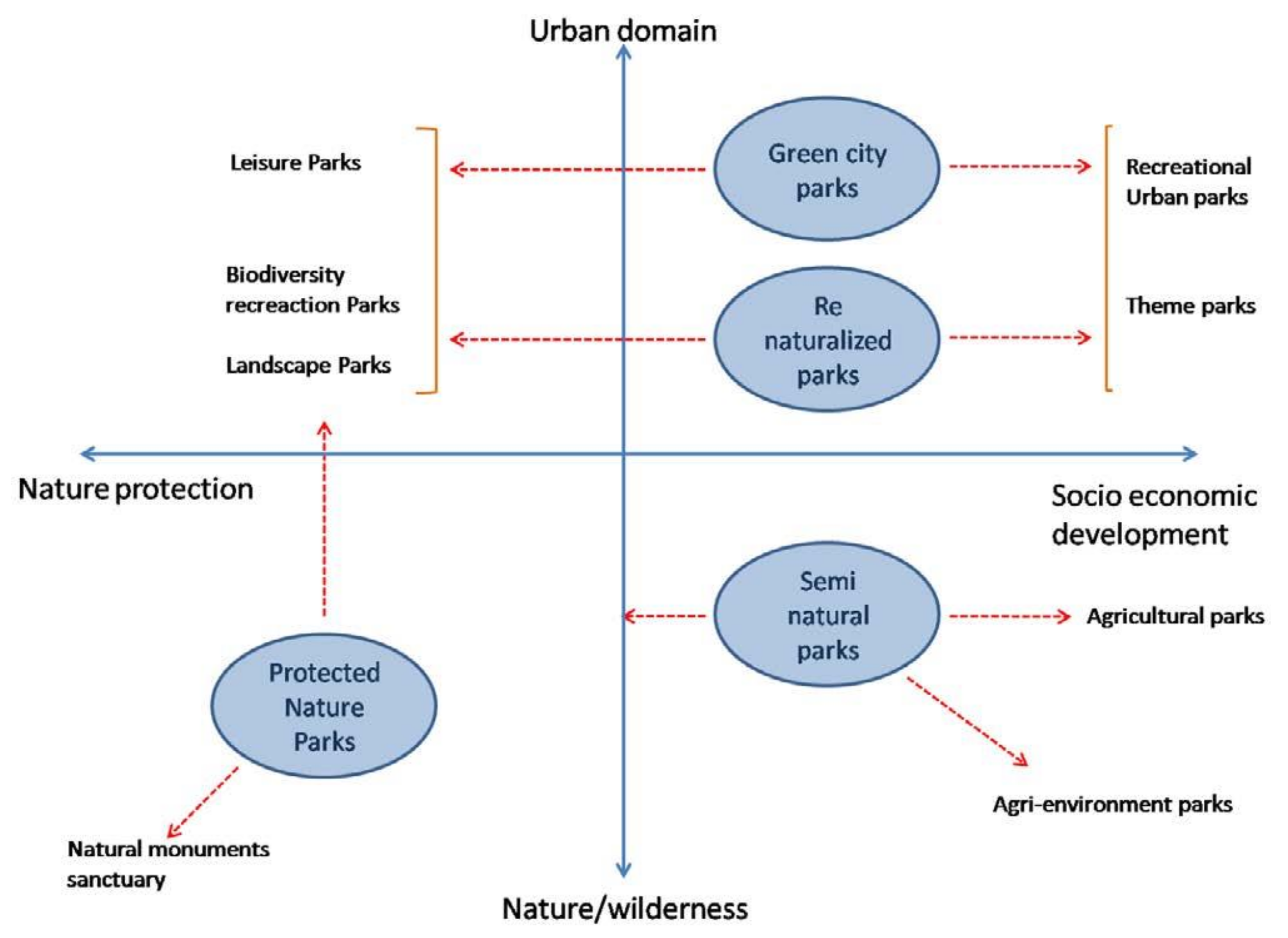
These parks have characteristics and roles that distinguish them from other natural or green areas, such as their proximity to the urbanised area, the social functions they perform, linked to the expansion of cities, and their level of biodiversity (ecological values and legal protection status). Depending on their more or less “urban” and socio-economically oriented character, recent research funded through the European Interreg IVC program (Periurban Parks—Improving Environmental Conditions in Suburban Areas) has identified some conceptual park types (
Figure 1), that often coexist in the same park [
30]:
Protected natural park: composed of areas of high natural, landscape, or cultural value. Characterised by high biodiversity. The prohibition of certain uses can have a significant impact on development processes.
Semi-natural agro-ecological park: a mixture of natural areas (ecological areas, such as green corridors) and artificial areas (agricultural land, forests, or wetlands).
Metropolitan park (Green City Park): green area located near or within the urban area, with functions related to local use and directed to residents.
Re-naturalised park: a previously degraded landscape that has been partially or completely restored.
Figure 1.
Concept map of peri-urban park types. Source: [
30] p. 13.
Figure 1.
Concept map of peri-urban park types. Source: [
30] p. 13.
The added value of peri-urban parks lies in their ability to respond to a multitude of issues that represent the main challenges our territories are facing today through the provision of multifunctional environmental, territorial, and social services: environmental protection and the provision of ecosystem services, the creation of green infrastructure, local economic development, improving the quality of life and promoting social inclusion. It is above all the category of agricultural (or agro-ecological) parks that respond to the need for multifunctionality, as places in which to experiment with new productive relations and use of peri-urban territories, restoring centrality not only to the rural world but also to open spaces [
10].
Peri-urban parks, especially those defined as ‘semi-natural agro-ecological, are an appropriate active policy tool for implementing a reconciliation between town and country and, therefore, a perfect container for multifunctional agriculture and tourism. The opportunities offered by proximity to consumer markets, growing consumer awareness of issues such as quality (organic farming), food safety, traceability, and social demand for new activities (leisure, training, environmental education, agritourism, etc.) make peri-urban agriculture an important tool for tourism development. These areas also play a key role in land-use planning, as they prevent the unlimited growth of cities, generate landscapes, and humanise urban environments. Moreover, they act as a green lung for large cities, increasing the level of biological diversity.
However, there are potential problems. There is a risk of turning a peri-urban area designated for tourism into a ‘theme park’ if the real protagonists, the farmers, disappear. This is why there is an ever-increasing need to flank traditional agriculture with other activities, still linked to cultivation, but whose aims are purely recreational, social, therapeutic, educational, or landscaping.
In this sense, peri-urban parks must be conceived in a broad territorial context to which they provide their services and of which they are structurally and environmentally part. Only in this way will it be possible to articulate the spatial, economic, social, environmental, or governance strategies that the management of these spaces requires.
Concerning this last point, the INTERREG IVC Periurban Parks project uses a questionnaire survey of 63 parks across Europe to highlight four main management models. In order of importance, the most common model is direct management by a local authority (38%). The other three models have very similar percentages: direct management by a regional administration (17.5%); management delegated to a specific public body (16%); and management by a consortium of different administrations (16%). The remaining percentage is divided between mixed public/private management systems (4.8%) or supra-municipal organisations (7.9%) (
http://www.periurbanparks.eu/live/index.php?a=open&id=4c99fc98837e2&ids=4c8ff07964a15&l=en (accessed on 11 December 2020)).
Against this backdrop, the authors of the project emphasise that peri-urban parks, being the urban–rural interface, are areas that require strong coordination to allow the integration of different functions and thematic areas. To this end, the most appropriate management unit, like the planning unit, must be an independent structure that is responsible not only for day-to-day administration but also for more structural issues such as coordination and implementation of long-term planning. This is the only way to guarantee the interaction between policies, plans, and projects in their creation, management, and maintenance phases. An independent structure also facilitates the integration of the park into local development strategies. A second key element for the success of the park should be inter-institutional agreements. The versatility of these spaces requires a relationship between different administrative levels, with the specific participation of local corporations and civil associations.
The establishment of peri-urban parks must include the drawing up of a strategy document (a medium to long-term “vision”), which contains an idea-guide to direct change, working on the identification and creation of a driving “cognitive chain” to prevent intervention in the identified project areas from being a sum of fragmented projects. The central elements of this document are the identification of innovative subjects (which determine the choice of the chain itself) and competence centers in the area (or external), and the indication of the paths of change and the relative ways to pursue them, through the explanation of a series of actions and interventions.
Only the explanation of the expected results, and the criteria for their measurability, consistent with the objectives of the strategy, associated with their appropriation by the community, built through intense fieldwork and an open comparison with the territory and with the relevant actors of the partnership, will generate the social pressure necessary to provoke the change.
5. Peri-Urban Agricultural Parks towards the Touristic Use Dimension
As highlighted in the previous paragraph, the agricultural park represents a particular type of peri-urban park, whose structure is made up of those elements incorporated over time by agricultural activity (pathways, irrigation system, vegetation elements, architectural structures, etc.). The configuration of the agricultural park is mainly made up of the layout of the fields, the crops, the terraces, the fences, the existing inter-podal paths and new pedestrian and cycle paths, which allow accessibility and use, the water system, wells and irrigation channels, and the rural architecture (cottages and farmhouses).
An agricultural park is based on the revitalisation of an economic activity conducted in environmentally aware terms and, in fact, constitutes an innovation in the idea of the park, no longer seen as a structure designed for leisure time, but as a condition for sustainability of the settled activities and the environmental quality of the entire area [
31]. An evolution, therefore, in the vision of open spaces which, from residual and reserve spaces, subject to protection with the sole function of setting limits to the built-up area, become active and structuring elements of urban development. It constitutes an innovation in the idea of the park, as it combines the features of usability, accessibility, and aesthetic enjoyment of the urban park with the productive agricultural function which, developed in environmentally compatible terms, represents a prerogative of sustainability. These are no longer parks just for leisure time, but areas where sustainable multi-functional agriculture acts as a driving force for the entire structure. The countryside meant as a garden for the city, a place of production and pleasure at the same time.
The agricultural use of peri-urban territories also guarantees soil permeability, hinders erosion phenomena, and ensures groundwater recharge [
32]. Therefore, it is opposed to serious phenomena of degradation and environmental danger and lends itself to interventions that, on the one hand, safeguard the traditional functions of peri-urban agricultural activity and, on the other, develop new functions in response to the new demands of the contemporary city. The maintenance of the productive function is in this sense a compulsory step and all the others descend from it.
From the environmental point of view, agricultural parks (and green areas in general) play a fundamental role in purifying the air. They are, in fact, active in the immobilisation of some particular pollutants (dust, heavy metals) and in the metabolisation of gaseous substances (CO, NOx, H2S) emitted by some anthropic activities that are mainly located in or near the city (industries, vehicular traffic, heating systems, etc.) [
33].
The agricultural parks in Italy, which also respond to the need to support peri-urban agriculture that for many decades was considered ‘transitory’, have in common—despite the diversity of the territorial contexts in which they have developed and the different strategies implemented for their establishment (top-down or bottom-up)—the objectives of environmental protection and biodiversity, the protection and enhancement of the landscape and culture of the rural territory, the preservation of the soil (against building squatting), the enhancement of multifunctional agricultural activities as strategic elements of territorial development, as well as recreational, cultural and educational use. It is clear that, depending on the type of park, substantial differences emerge: in some cases, there is a greater propensity towards environmental protection; in others towards the promotion of agricultural and recreational activities. However, the identification of the objectives depends above all on the specific features of the area in which the park is set up and its socio-economic and cultural characteristics. As in the cases of the Parco Agricolo di Ciaculli in Palermo and that of the Pasm, activities that move towards the multifunctional enhancement of agriculture, as well as those linked to production and marketing and environmental sustainability, are highly encouraged.
5.1. The “Parco Agricolo di Ciaculli”
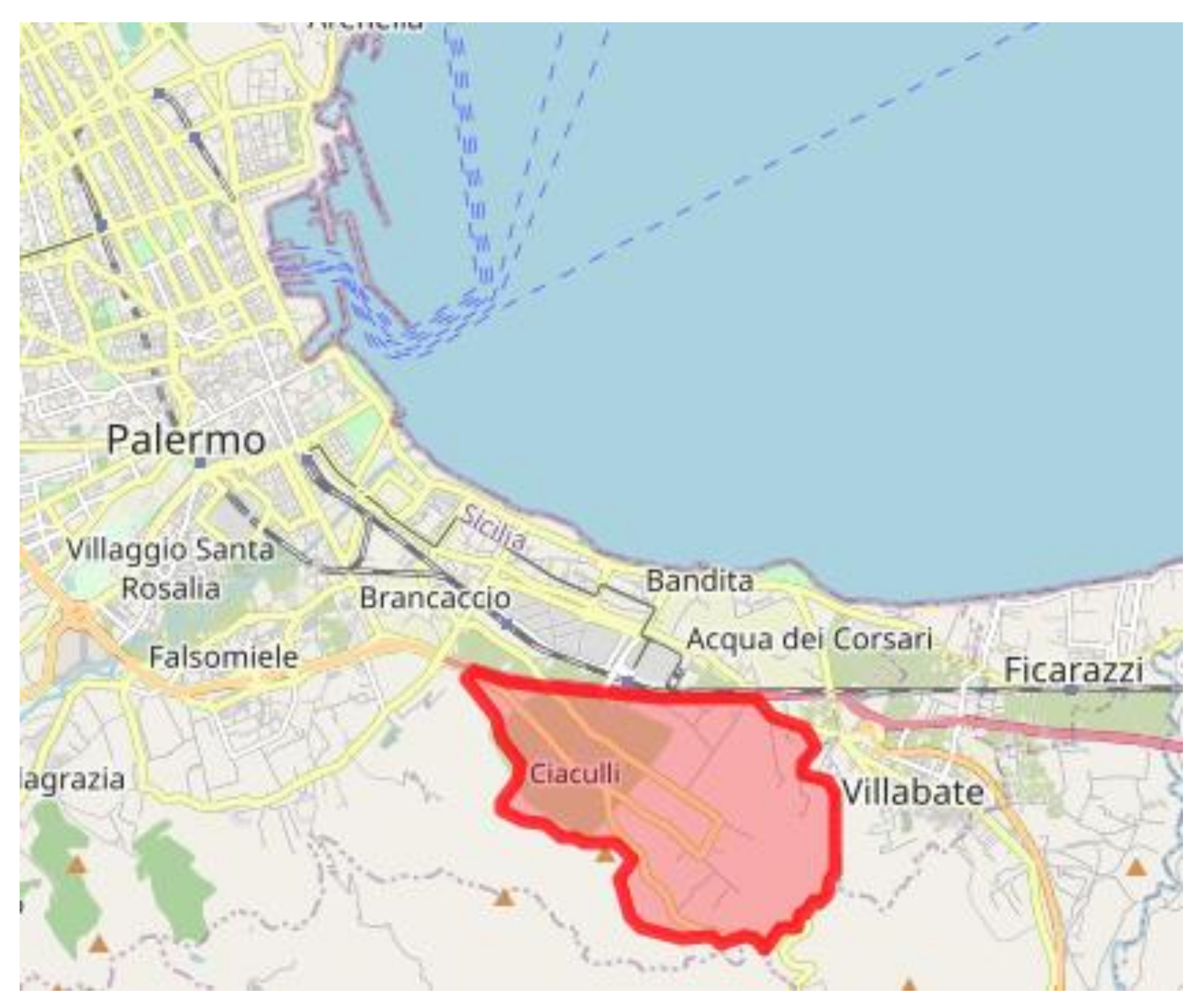
The area covered by the Parco Agricolo di Ciaculli is the last extensive agricultural area in the municipality of Palermo. It covers an area of 850 hectares in the districts of Ciaculli and Croce Verde and constitutes the last strip to the east of the plain of Palermo, representing a green lung for the city (
Figure 2). To the north it joins to the urban edge of Palermo and looks out towards the sea, to the south it closes in on the Monte Grifone mountain system. Its agricultural and socio-economic characteristics make it part of the residual peri-urban strip that has survived urban expansion. Given the prevalent agricultural use of its soils, Ciaculli, which has maintained the original features of the historical rural landscape of the vast plain of Palermo (covering about 100 square kilometers and called Conca d’Oro) at the beginning of the 20th century, represents, in terms of the level of intensification and homogeneity of cultivation, the largest agricultural and mandarin area in this area.
The main factors that have contributed to the development of mandarin-growing in Ciaculli are the soil and climate characteristics, such as the depth of the soils, which allow extensive root systems to develop, the balanced texture and structure, which allow water to be constantly maintained in such a way as to prevent asphyxia, the rich supply of organic substances and mineral nutrients, a mild climate with plenty of sunshine, the frequent presence of winds that keep the relative humidity low, and a very rich water table [
34].
One of the important peculiarities of the ‘Tardivo’ is that its trees grow on very steep slopes, such as those that characterise the agricultural park, with gradients of up to 50%. This is why the land was terraced at the beginning of the century (using pieces of rock, known as ‘ciachi’ or ‘ciaca’, which fell from Monte Grifone) and monorails are used in the steepest areas to facilitate harvesting (
Figure 3).
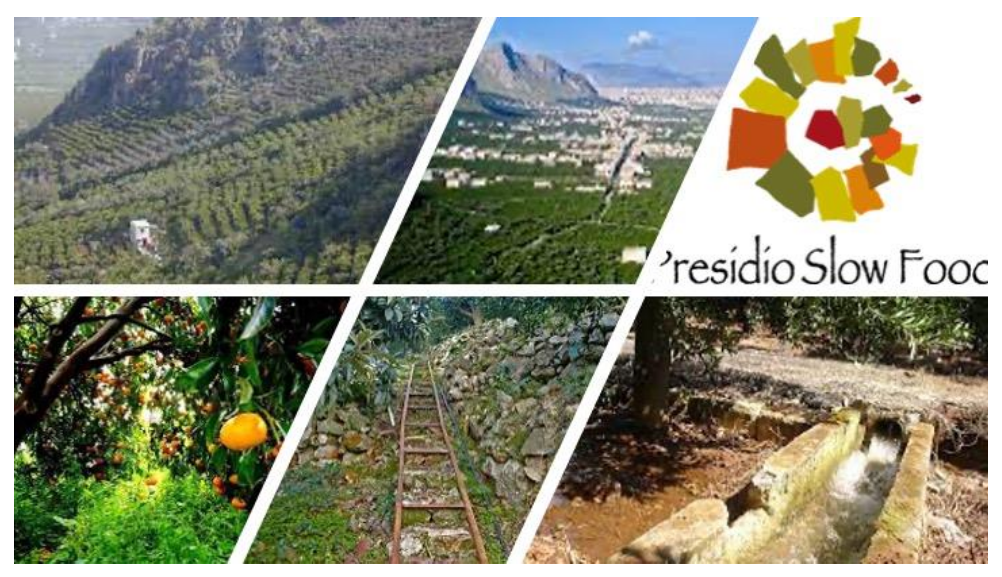
The Tardivo is also the identity element of the agricultural park, which has made it its flagship. A Slow Food Presidium since the end of the 1990s, it has become a reference product for consumers as well as being widely used in confectionery and cosmetics, which make use of its rich essential oils. Known locally as ‘marzuddu’, the mandarin used to ripen in March (i.e., late), but today, due to the ongoing climate change, it is harvested a month earlier and is therefore not difficult to find them on the market as early as February.
The production and sale of the ‘Tardivo di Ciaculli’ mandarin are managed by the ‘Consorzio il Tardivo di Ciaculli’ (
https://www.tardivodiciaculli.net (accessed on 20 May 2021)), which also aims to be a means of preventing the social, economic, environmental, and landscape degradation of the park area, and a means of enhancing the value of the historical buildings, beams, and villas, which were once closely linked to the agricultural world and are now in danger of falling into disrepair.
The park project, prepared by the Confederazione Italiana Agricoltori (Italian Farmers Confederation), was financed under the European Community’s Life programme in 1994 (the project was presented under the Life94 programme under the name “Agricultural management model in a peri-urban area of Palermo”) and was implemented between 1996 and 1998. Close dialogue with the municipal administration, which was drafting the General Regulatory Plan (PRG) at the time, gave the project further strength by including the project area in the town planning instrument and thus formally recognising its intended use. The aim of the project, which won the Sustainable Cities Award in 1999, was to define a management model for a peri-urban agricultural area by safeguarding the traditional functions of peri-urban agricultural activity and, at the same time, developing new functions in response to the new demands of the contemporary city. The preservation of the productive function was in this sense a compulsory step [
35].
The park [
34] has been created starting from the elements of the historically formed agricultural system, highlighting their role in defining the specific overall relationships and their degree of persistence, and planning interventions for the conservation, recovery, restoration, or replacement, based on their intrinsic value, of architectural and environmental assets. The entire area was affected by interventions to safeguard the traditional functions of peri-urban agricultural activity, in particular, the productive function since the best protection of territory is achieved by assigning or maintaining compatible uses. The recovery project focused on the environmental requalification along the foothills, through the arrangement and recovery of abandoned and degraded areas, the restoration of some elements of the terraced agricultural landscape and the creation of a 5 km long path, the main axis of the project, which winds along the whole terraced foothills, between 100 and 200 m above sea level, and crosses private agricultural lands, allowing accessibility and fruition to visitors.
Alongside this axis, a system of routes has been identified which is divided into three types: routes of historical and architectural interest, routes of landscape and environmental interest, and mountain paths. The first step was to choose a network of routes structured on existing tracks, to recover the “bagli” (buildings containing a courtyard) and reuse them for social, residential, and park service purposes, and to redesign the access to routes leading to them. In addition, a series of maintenance, restoration, and partial reconstruction works have been carried out on the dry stone walls (approximately 5000 m), using traditional techniques, as well as works aimed at restoring the slopes by planting trees and shrubs (approximately 6000 species) typical of the woodland and Mediterranean scrub (walnut, azarole, rowan, mulberry, olive, almond, etc.). The agroforestry and renaturalisation measures concerned, in particular, the mountain slopes (about 15 hectares) affected by floral impoverishment and abandonment of olive and almond groves with consequent hydrogeological instability. The actions carried out mainly concerned the reforestation of the slopes through naturalistic engineering measures to counteract the disruptive effect of rainwater running downhill. In addition, work has been carried out to restore abandoned citrus groves identified in the analysis and project phase.
The interventions have aimed at their recognition, defense, and valorisation, being aware that they are positive externalities that for the most part cannot be represented in the company’s balance sheet, but must essentially be recognised as benefits of collective interest and supported by public interventions.
In the same direction are the measures aimed at enhancing the park’s two particular environmental and cultural functions directly linked to the history and tradition of the Conca d’Oro, such as the creation of the Garden Museum of Agriculture of the Conca d’Oro and the Museum of Germplasm of the Conca d’Oro and the Varietal Comparison Field, consolidating the relationship between research activity (the Institute of Arboreal Cultivation of the University of Palermo and the C.N.R.) and production activity.
An important element in the realisation of the park was the participation and sharing of the entire process with the local players, also because it had the merit of intervening in an area and a sector in economic crisis, giving a response that contained, as far as possible, elements of revitalisation.
To this end, an intensive sensitisation and information campaign was carried out before the start of the works, since the consent of the owners of the land concerned was necessary for the implementation of the project. A census of all the owners was carried out and an agreement was drawn up for the authorisation of the work by private individuals. The interventions involved a total of about 400 land parcels and the consequent signing of 400 agreements with the same number of owners. The involvement of the local actors was then carried out through the presentation of all the project phases and their verification with the inhabitants-farmers who own the agricultural areas, the adhesion and active participation in all the project phases of the inhabitants-producers, and the establishment of a co-operative of unemployed people living nelle frazioni di Ciaculli e Croceverde Giardina (Cooperative “Il nespolo”) for the execution of all the interventions [
36].
The agricultural park of Ciaculli is, therefore, based on a conception of agriculture which operates as an active process and which determines, over a long time, changes in the territory in ways connected both to the protection and recovery of the landscape but also to the pursuit of productivity and economic rationality, and at the same time also expresses the production of the environment and services.
The idea is that territory of significant extension cannot be managed and economically sustainable by using only public resources in the future, but on the contrary, a policy of incentives must be envisaged, mobilising largely productive private resources.
5.2. The Parco Agricolo Sud Milano (Pasm)
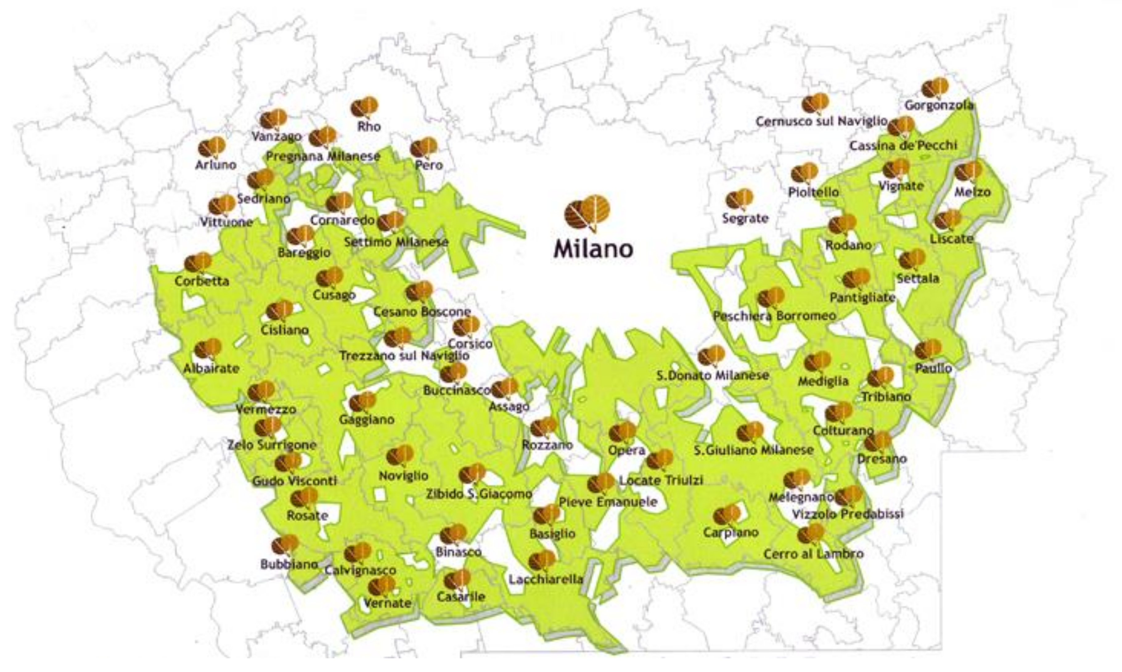
The Pasm (
www.cittametropolitana.mi.it/parco_agricolo_sud_milano (accessed on 20 May 2021) covers 47,033 ha, about 30% of the total surface area of the Metropolitan City of Milan (Lombardy Region). The utilised agricultural area (UAA) is 30,000 ha and there are approximately 1000 farms in the territory. The area includes the plain south of Milan and involves 60 municipalities (
Figure 4). The park was established by Regional Law n. 24 of 1990 (later replaced by Regional Law n. 16 of 2007) as a regional agricultural park and a regional park of the metropolitan belt. As there is no legislation in Italy explicitly concerning agricultural parks, the regulations of Pasm are inspired by the principles of regional law no. 86 of 1983 concerning the General Plan of regional protected areas. Its management, originally entrusted to the Province of Milan, is now the responsibility of the Metropolitan City of Milan. Pasm only began to be operational in the early 2000s [
8].
The aims of the park, defined by the regional law of 2007, are to protect and restore the landscape and environment of the strips linking the city and the countryside, to connect the external areas with the urban green systems, the ecological balance of the metropolitan area, the safeguarding, qualification, and development of agro-silvicultural activities, and cultural and recreational use. The managing body, the Metropolitan City of Milan, is flanked by the Metropolitan Council and the Governing Council as governing bodies; the Assembly of Mayors, an Agricultural Technical Committee, and a Landscape Commission are also involved [
8]. The planning instruments of the Pasm are the Territorial Coordination Plan (Ptc), the Management Plan, the Sector Plans, and in particular the Agricultural Sector Plan.
Agriculture is undoubtedly the driving activity of the system of territorial and environmental protection: its main characteristic is, therefore, that of conserving the territories of an agricultural nature by enhancing the value of various crops ranging from maize to rice, meadows, and autumn and winter cereals. It is no coincidence that one of the main “themes” represented is agriculture and the protection of agricultural activity understood as the complex of operations aimed at cultivation, the management of forestry resources, livestock breeding, as well as the processing and marketing of products. However, given that this is multifunctional agriculture, it is important not to overlook the set of activities aimed at the use of the territory by citizens and the management and maintenance of the environment. The use of the area is a further distinctive element of the park, in addition to its landscape purpose. These issues are addressed through the activation of several services: food production, catering, direct sale, accommodation, environmental education, environmental services, landscape and biodiversity maintenance, sports activities, rural tourism itineraries.
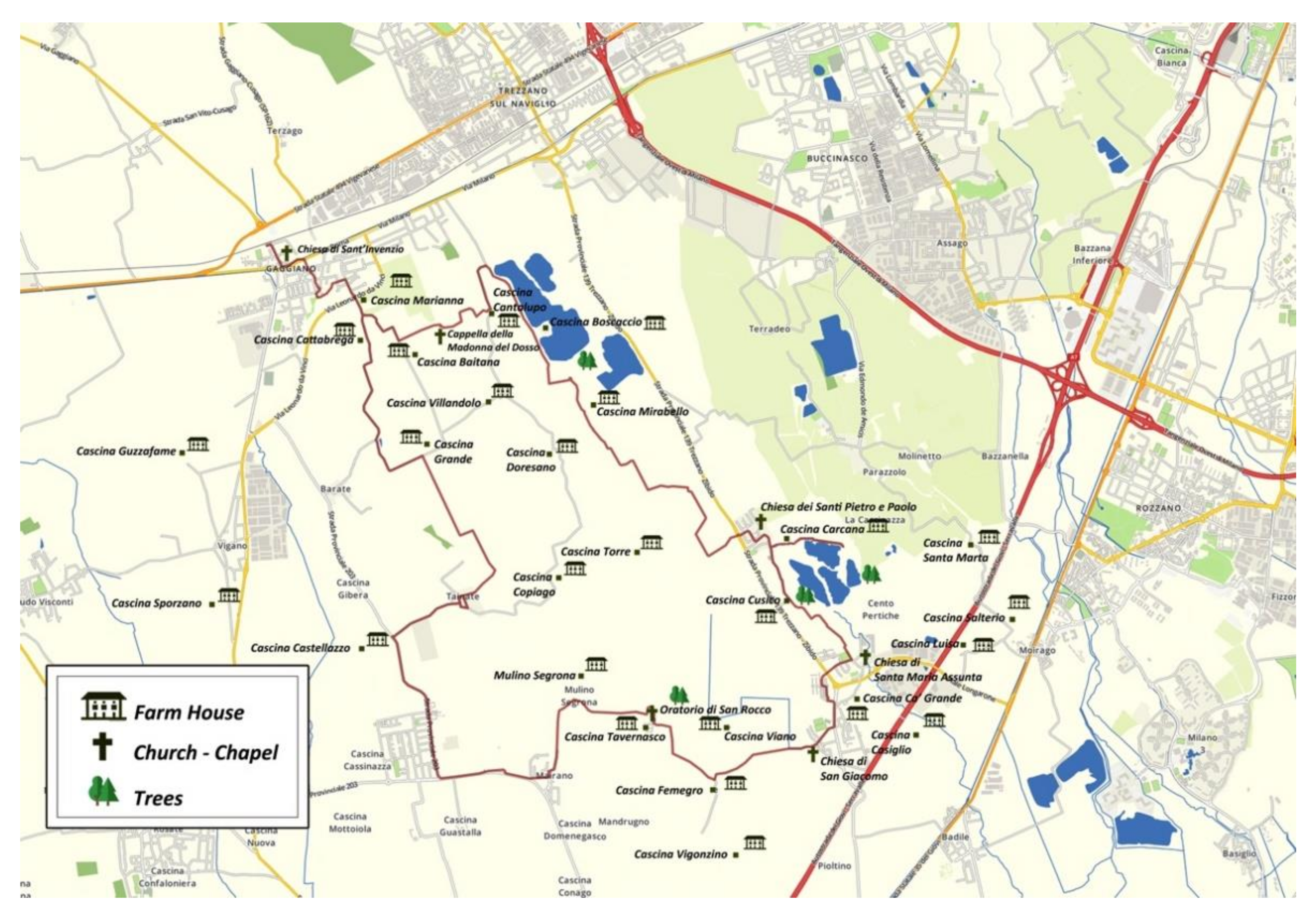
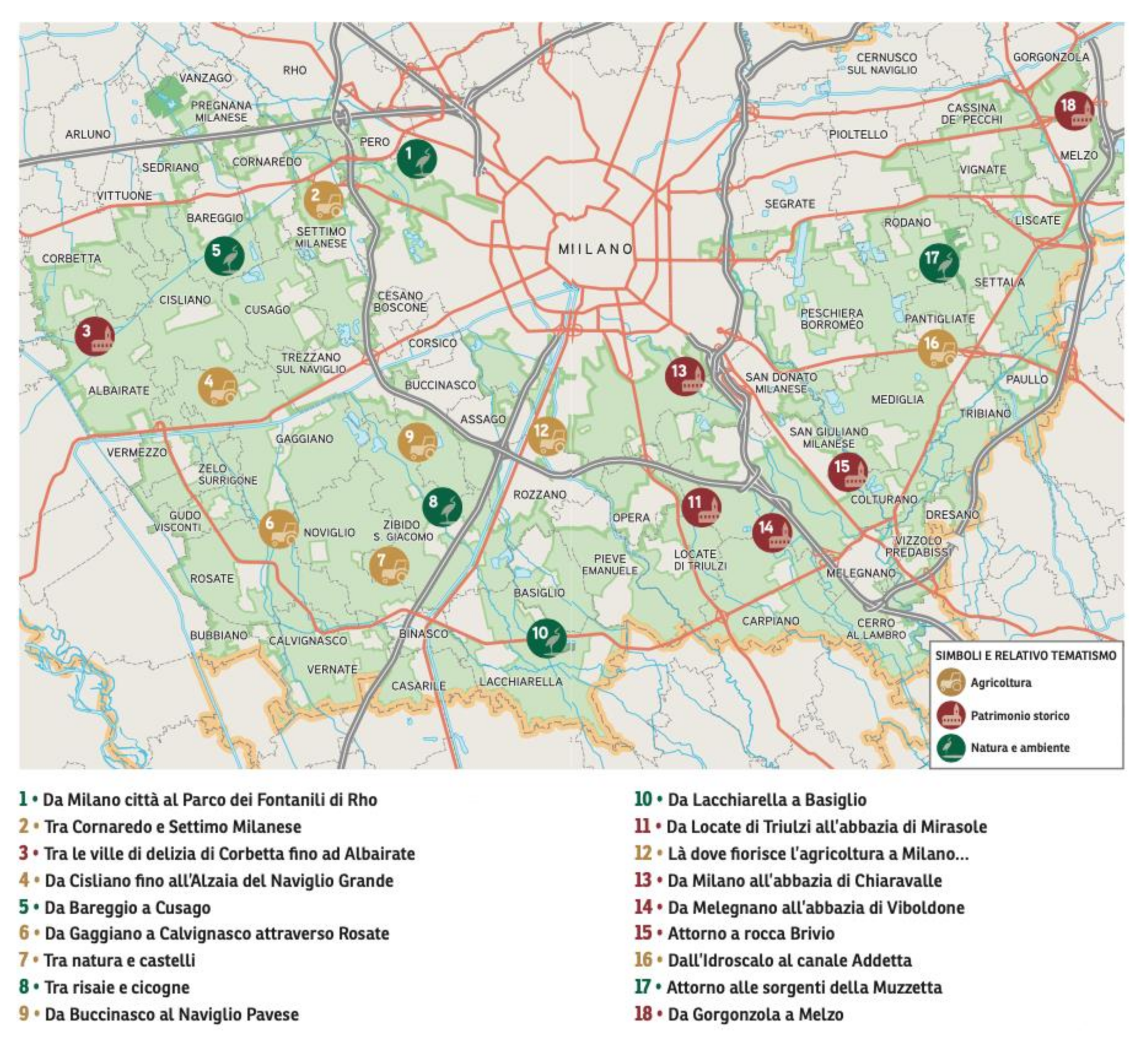
Tourism and the possibility of developing routes linked to sustainable mobility were the focus of the “Landscape Expo Tour”, which involved 30 municipalities in northeast Milan, from Arese to the Parco Sud to Cusago and Gaggiano. The project was born out of reflections on the Expo (2015) and thanks to the contribution of Fondazione Cariplo and the support of the municipalities of northwest Milan, whose target was to enhance and enjoy a renewed identity of the landscape of the places involved. The project looked at the possibility of creating a system of natural, historical, and architectural resources and agricultural and food production through the creation of green tour itineraries that can be traveled by bicycle or on foot to introduce residents and tourists to the area, its landscape, and its excellence. In this project, the support of the Pro Loco and local authorities was important, as they encouraged the activation of participatory processes and wider involvement of citizens. In particular, the “Let 4. Terre d’Acqua e Cascine” itinerary, 28 km long (
https://www.parcoagricolosudmilano.it/itinerari/98-let-4-terre-d-acqua-e-cascine.html (accessed on 20 May 2021), which takes place in and explores the Parco Agricolo Sud Milano, along the Naviglio Grande that overlooks Gaggiano, identifies four main objectives: cultural promotion, landscape-environmental qualification, enhancement of usability and economic sustainability (
Figure 5). There are many other itineraries in the park that refer to a wide range of themes: from the wealth of cultural resources to the environment and landscape. Eighteen itineraries are proposed by the “Cartoguida” of the Italian Touring Club [
37], which, through a map and a booklet, aims to inform users about the four different purposes—nature, landscape, history, agriculture—that have given rise to the park, underlining the uniqueness of the places and the extraordinary heritage that potential tourists can enjoy. Museums, abbeys, farmsteads, irrigation ditches, rice fields, mills, ancient icehouses, lakes, woods and nature reserves are the icons of a landscape whose historical cycles are the result of a significant sedimentation of territorial resources, through which the history of places, territorial knowledge and rural memory can be told (
Figure 6 and
Figure 7). Not only is tourism stimulated by slow mobility practices, but also linked to agri-food activities and farm holidays. “Parc—agricultural products in catering”, a project conceived thanks mainly to the collaboration of 22 Pasm companies to meet the growing demand for local and quality products and to strengthen the link between producers and consumers, is aimed at the latter.
The app has been recognised as a privileged tool for disseminating knowledge and wider use of the park’s places, nature, agriculture, landscape, and history. The technological dimension has been consolidated and enriched by also embracing the possibility of “accessing” augmented reality content. This is an innovative way of getting to know the territory, its heritage, and the initiatives that Pasm promotes.
Therefore, the park is progressively implementing various projects that also include innovative proposals from the point of view of digital technologies to strengthen the tourist offer in the face of an increasingly demanding demand. It is necessary to strengthen integrated and long-term strategies, to be developed together with the various stakeholders—citizens, enterprises, institutions, associations—also with a view to the realisation of a coherent and effective tourism communication strategy. The park’s managing body still lacks a overall strategic vision and a proactive approach, limiting itself almost exclusively to pursuing a defense policy. In many cases, innovative projects have been carried out not by the authority, but by committees, local associations, and private bodies.
Although the park and its territory have a more agricultural vocation, with particular attention to the care and preservation of the environment, innovation could come from more creative forms of tourism.
6. Results
The existence of relations between the urban and rural components implies the idea that there is something that can be called “urban” and something else “rural”. The need to distinguish between these two territory’ conditions has led to various proposals and experiences. From a more purely legislative point of view [
38], the policies that have variously concerned the urban–rural relationship (which can be traced back to three types of approach: formal, constraining, and programmatic) have highlighted different forms of relationship between these areas that can be summarised in three typologies: the subjugation of rural to urban space, maintenance of a clear separation between rural and urban, and creation of hybrid spaces.
However, “urban” and “rural” are not entities that exist independently of human practice and special interests: rather, the nature and character of these categories depend on how they are defined.
Of particular interest in this type of relationship is the portion of land in contact with the two areas, or rather at the border of both, where one ends and the other begins. An increasingly blurred space that is not clearly defined [
2,
13,
39,
40,
41,
42], which sees, on the one hand, the urban “infiltrate” and branch out into the rural, on the other hand, the rural does not completely give way to the urban, maintaining “enclaves” within the urban component. This dynamic translates into what is today, among other definitions, identified as peri-urbanization.
These borders’ territories are crossed by flows of people and materials [
1], economically, politically, socially, and physically through issues such as housing, employment, education, transport, tourism, and resource use. In some cases, these flows are predominantly unidirectional (as in the case of cultural activities or waste flows), while in other cases there are important flows with a bidirectional character (as in the case of recreation and tourism), connecting and mixing urban and rural areas, farmers and citizens, and generating multifunctional activities.
As highlighted by the study cases shown, if properly managed through the creation of agricultural parks, the peri-urban areas can become poles of attraction for urban contexts that give them new functions combining environmental regeneration with the supply of quality food products, the creation of playgrounds, and recreational spaces with training and educational activities [
43]. Moreover, this governance tool allows farms to enter new markets and expand their activities, contributing to sustainable development by involving their stakeholders and communities around common targets [
44].
In particular, the characterising factors of the agricultural parks analyzed, in terms of enhancing the value of peri-urban open spaces in touristic terms, are as follows:
- -
rediscovery and re-use the rural characteristics in terms of dynamic valorisation, and the implementation of a model of diversified and multifunctional agriculture oriented towards tourism;
- -
ecological-environmental rebalancing of the city–countryside relationship;
- -
restoration and environmental landscape;
- -
rehabilitation of the agricultural habitat;
- -
revitalisation of an identity production function through a sustainable economic model;
- -
protection, enhancement, and sustainable development of land resources;
- -
maintenance of biodiversity, i.e., maintaining sufficient variability within each species to ensure that its genetic potential can be used for the future;
- -
participation and involvement of citizens and local players to make them reappropriate a portion of the territory that was previously inaccessible.
7. Discussion
The process of urbanisation will continue to grow exponentially in the coming decades and cities in all countries have to face the challenges posed by urban sprawl. This strong urban sprawl does not, however, manifest itself as a clear advancement of the urban boundary at the expense of the rural, but by creating an intermediate zone where the two categories blur into one another. Much of the territory of Europe is neither distinctly urban nor rural but something ‘in-between’ [
45]. These marginal territories see a progressive abandonment of arable land and fragmentation of natural and agricultural areas.
The redemption of these territorial areas passes through the enhancement of open green spaces i.e., ‘predominantly unsealed, permeable “soft” surfaces’ [
46] (p. 96), which have been spared from widespread urbanisation.
However, this action has to be accompanied by a planning action defining the development strategy (a medium- to long-term “vision”) and framed in a management framework able to guarantee the relationship between different administrative levels, with the specific participation of local corporations and civil associations.
The importance of planning open spaces is underlined by Sandercock [
47] (p. 134), who states that “[planning is] an always unfinished social project whose task is managing our coexistence in the shared spaces of cities and neighborhoods in such a way as to enrich human life and to work for social, cultural, and environmental justice”. This means that planning green open spaces in the peri-urban territories, through defining the economic model and strategic vision, is a central issue for sustainable development. In this framework, agricultural parks could be a possible answer and can act as driver for the development of tourism in these territories as long as are able to define a strategic vision focused on agricultural, recreational, social, ecological, and didactic functions.
More in detail the agricultural-productive function, has to be devoted with particular reference to the recovery of traditional cultivation techniques and the planting of organic crops, i.e., that respect the natural cycle of plants without the use of chemicals, fertilisers or anything else that could pollute the soil or groundwater; the recreational function has to be developed through the creation of routes and the recovery of rural structures already present in the area to be converted into agritourism to which the organisation of events can be added, such as theme days dedicated to the tasting of typical products or cultural events linked to food, to bring citizens closer to the countryside and to amortise the park’s management costs; the social function, has to be implemented through the involvement and participation of residents and the various local players, to create a strong sense of identity and possibly extended to weaker categories (the elderly, the handicapped, children) or to people assigned to perform socially useful tasks; the ecological-environmental function, has to be focused on the development of an environmentally friendly agriculture, oriented to contribute to the protection and conservation of resources (e.g., protection of land from soil sealing) and the bioclimatic balance of peri-urban ecosystems; and finally the didactic-scientific function, must be oriented to enter into agreements with universities for the creation of research laboratories, or with schools to develop environmental education programs to bring students closer to nature, a fundamental action to spread respect for the environment in future generations.
In this context, from the case studies analysis, some particularly significant elements emerge as central to ensure that agricultural parks can be a tool for tourism development.
The first concerns participation and sharing with the various local players, as in the case of Ciaculli Agricultural Park, both to define the feasibility of the project, the timing, phases, and methods of implementation and to identify priority objectives, and to build an identity. The main promoters of the agricultural park will be its inhabitants and the farmers working there. If they do not feel part of the project, if they do not feel the place as their own, any activity and initiative will be doomed to failure.
The second concerns the choice of management model, which is fundamental for maintaining the functions of the agricultural park over time. As shown by the case of the Ciaculli Agricultural Park, the management of the park could be entrusted to agricultural cooperatives through specific agreements, which define the compatible activities and prescribe the methods of implementation, the timeframe, and the possible interventions. This hypothesis could allow farmers to use productive land in public ownership at an affordable cost, while it would guarantee the revitalisation of areas that would otherwise be abandoned, as is often the case. In addition, the proceeds from the sale of agricultural products could be used, in part, for park maintenance and for strategies to promote and market agricultural products.
The third, as in both analyzed cases, concerns the choice of interventions and activities that take into account the compatibility with the natural vocation (present or past) of the area, the availability of renewable resources, the connections and interactions with neighbouring areas as well as the main user needs to be satisfied. Without such attention, the risk will be to create landscapes without identity, or in the words of Augè, “non-places” [
48].
The last concerns the use of digital technologies, as shown by the case of Pasm, to develop sustainable tourism. Today touristic flows are mainly oriented by virtual certifications of quality (such as Tripadvisor, Booking or similar) and tourist tends to create personalised routes, so the parks will attract more tourists the more information and digital tools they can put on-line.
8. Conclusions
With the acquisition of the multifunctional agricultural character, peri-urban territories become “territories of agro-food production, reserves of environmental quality, a tool for the containment of land use, a place of production of goods and services of a public nature” [
43] (p. 29). In other words, the peri-urban area takes on the compensatory role of the widespread urban reality, due to its production of environmental, ecological, cultural, landscape, and production values.
From this perspective, agricultural (peri-urban) parks are a fundamental tool for combating the ‘marginality’ and abandonment of peri-urban spaces, triggering development processes centered on a plurality of sustainable activities ranging from agriculture to tourism, and leisure. Leveraging on these, it is possible to reconcile the city and the countryside from different points of view (social, economic, spatial) and thus fulfill the aims of multifunctional agriculture, oriented towards the production of externalities, capable of satisfying a high demand for food, recreational and cultural goods [
49]. To all this must be added the necessary activation of participatory processes; of an action strategy that involves not only the institutions but also and above all the population.
However, for peri-urban areas to be able to provide effective responses to the community, triggering local development processes, it is essential that the multifunctionality of agricultural parks functions as it does in some “real” rural farms, i.e., that a potential tourist demand is also addressed and intercepted: the conditions must be created so that the tourist-consumer not only has the opportunity to enjoy the places but also to implement new tourist experiences that allow the local resources to be enhanced and the potential of the areas to be discovered. It is a question of building a relational path between the tourist and the territorial context by looking at the actual production activity: an exchange thus takes place between the tourist who has access to the resources and the production cycle and the producer who transfers his/her knowledge and territorial know-how. The final objectives become the places and their particular resources knowledge, and the creation of itineraries linked to environmental culture, wine and food culture, psychophysical wellbeing, etc. Given that rural tourism is receiving a very positive response in Europe, particularly in countries most sensitive to sustainability and eco-sustainability strategies, for agricultural parks to encourage peri-urban territories renaissance through tourism, in addition to activating specific development policies and planning tools, they must become true sustainability hubs. In this framework, the objectives of sustainable tourism—environmental preservation, zero-kilometer agriculture, typical products and resources, uniqueness of places—must become shared elements towards which the “activities” offered by the park should be directed. Rural (peri-urban) tourism thus becomes an important driver of local sustainable development, when integrated with multifunctional agriculture in a coordinated management framework. While caution should be exercised about emphasising the importance of tourism as a significant asset for local development, encouraging sustainable tourism could be a way of boosting the activities of agricultural parks and, in so doing, creating links and synergies between forms of protection, conservation, and local economies.
9. Limitations and Future Research Directions
The first experiences of Italian agricultural parks date back to the ‘90s, but it is from the beginning of the new millennium in particular that we see a greater diffusion of them supported by the growing awareness of the important role played by peri-urban agriculture, diversified and multifunctional, in safeguarding the quality of rural, urban and interstitial spaces. Even today, we are witnessing a proliferation of experiments that are not entirely clear whether they are ongoing, in the process of being defined, or finished, whether they are institutionally recognised or whether they are merely the result of an initiative by private citizens and/or planning companies.
However, this proliferation has not been accompanied by analogous normative and scientific production. If on the one hand this has opened up an avenue for new research, on the other it certainly represents a limitation that has resulted in an eminently theoretical and descriptive approach to analysis.
A limitation has also been reflected in our study, which has embraced an eminently theoretical and descriptive approach to analysis. However, precisely because of these characteristics, we intend to lay the foundations for a further in-depth study: in fact, we are currently working on the definition of an assessment matrix through which to analyze the specific features, the actions, the aims, the managing bodies (if any), the management strategies and the players involved, the main potential and the weak points in relation to the territory and its resources of the Italian agricultural parks.
The matrices identified on the basis of the distinctive characteristics of each agricultural park identified will be a contribution to understanding the role they play in territorial governance strategies and in the spatial planning process. At the same time, they will represent a useful tool for understanding whether this type of park can be identified as a system of functions and services for the regeneration of territories and the sustainable development of peri-urban territorial capital: in other words, an ecological unit of protection and territoriality.


