
Agricultural Water Management Using Two-Stage Channels: Performance and Policy Recommendations Based on Northern European Experiences

 , , , and
Abstract
:1. Introduction
- (1)
- Assess the key technical and environmental benefits of agricultural TSCs. The benefits were identified through a literature survey considering research under Boreal and Continental climates. Additionally, the performance of a reach-scale pilot site is demonstrated regarding flood mitigation, morphological stability, suspended sediment and phosphorus retention efficiency, and biodiversity indicators.
- (2)
- Evaluate the total costs and monetary environmental benefits of the TSC approach in comparison to the conventional dredging. The pilot-scale results were scaled up to a larger agricultural catchment considering a 60-year time period.
- (3)
- Investigate the bottlenecks in the financing and governance that are hindering the mainstreaming of TSCs. We provide recommendations on how to tackle the bottlenecks, including how to integrate TSCs into the CAP-AES based on their optimal spatial targeting with respect to other types of vegetated riparian buffers.
2. Materials and Methods
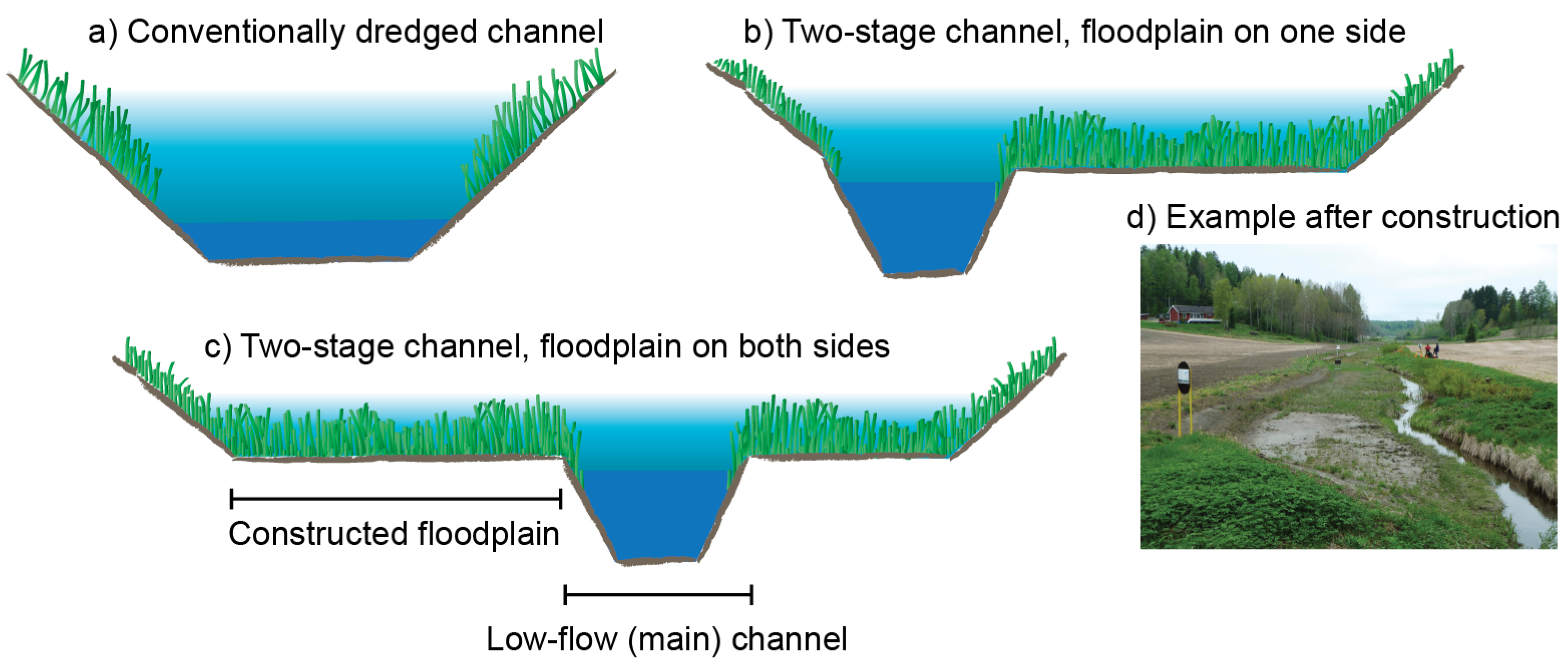
2.1. Description of the Two-Stage Channel Design Based on the Reach-Scale Pilot Site
2.2. Assessment of Technical and Environmental Performance and Benefits of Two-Stage Channels in Comparison to Conventional Dredging
2.2.1. Analyses of Flood Mitigation, Morphological Stability, and Nutrient Retention at the Primary Reach-Scale Pilot Site
2.2.2. Field Investigations on Biodiversity at the Primary Reach-Scale Pilot Site
2.3. Evaluation of Costs, Financing, and Monetary Environmental Benefits
2.3.1. Costs Based on Reach-Scale Pilot Sites
2.3.2. Monetary Environmental Benefits at the Catchment Scale
2.4. Analyses of Bottlenecks in Financing, Governance, and Capacity
3. Results
3.1. Benefits of Two-Stage Channels in Comparison to Conventional Dredging
3.2. Performance of the Case Study Two-Stage Channel
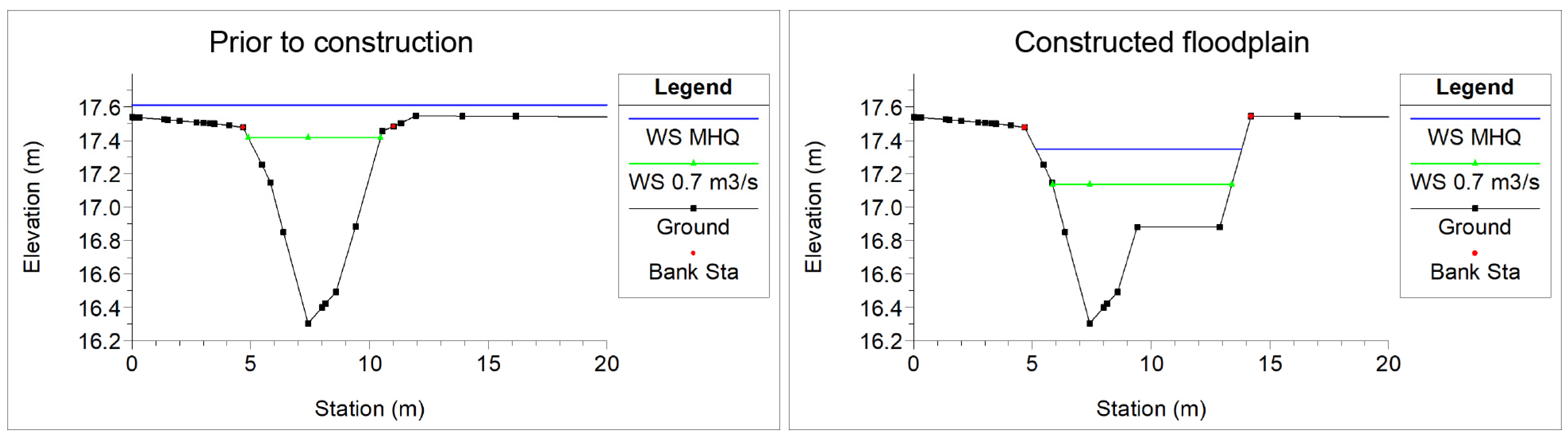
3.2.1. Mitigation of Flooding and High Water Tables
3.2.2. Retention of Suspended Sediment and Phosphorus
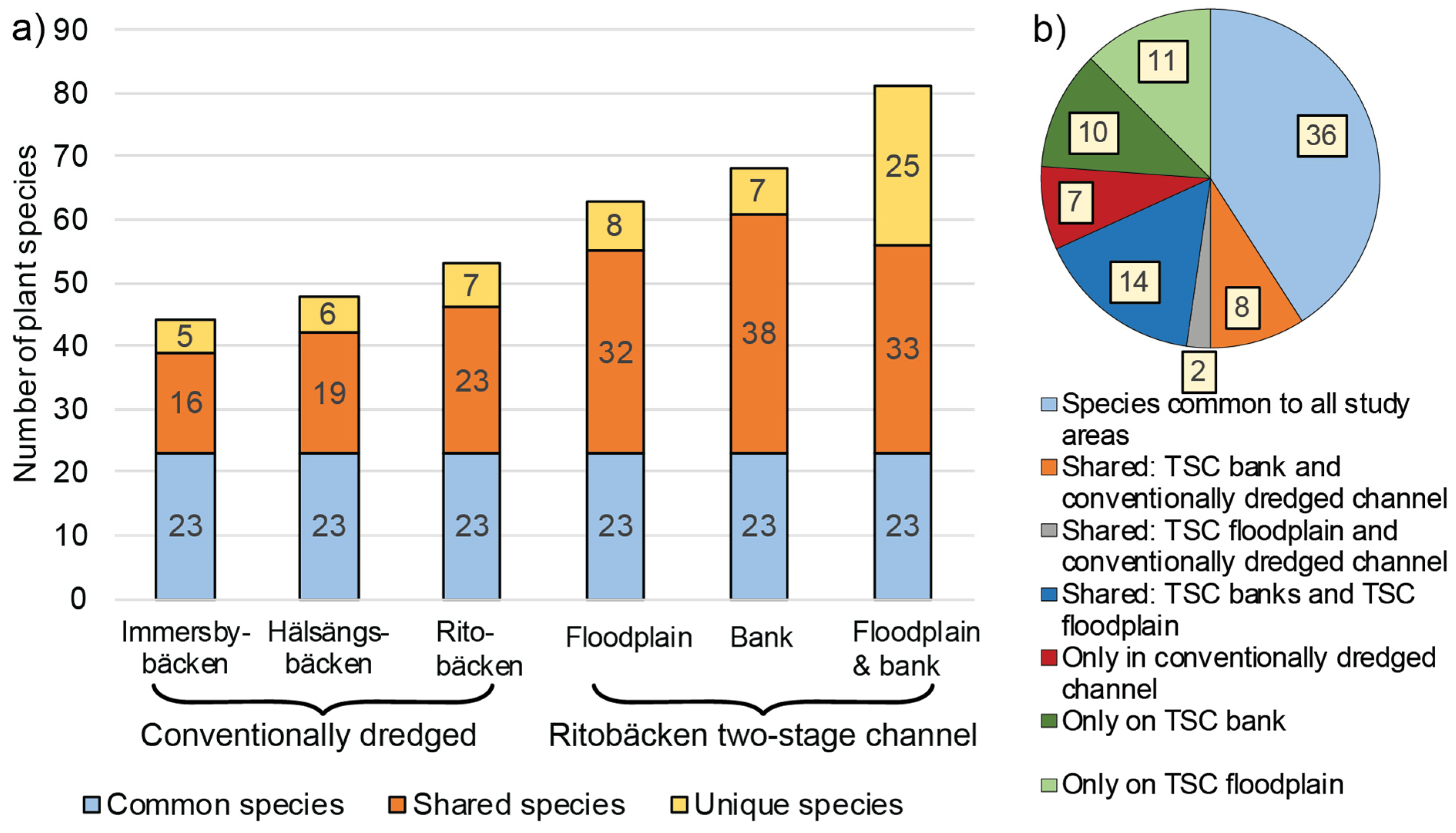
3.2.3. Plant Biodiversity
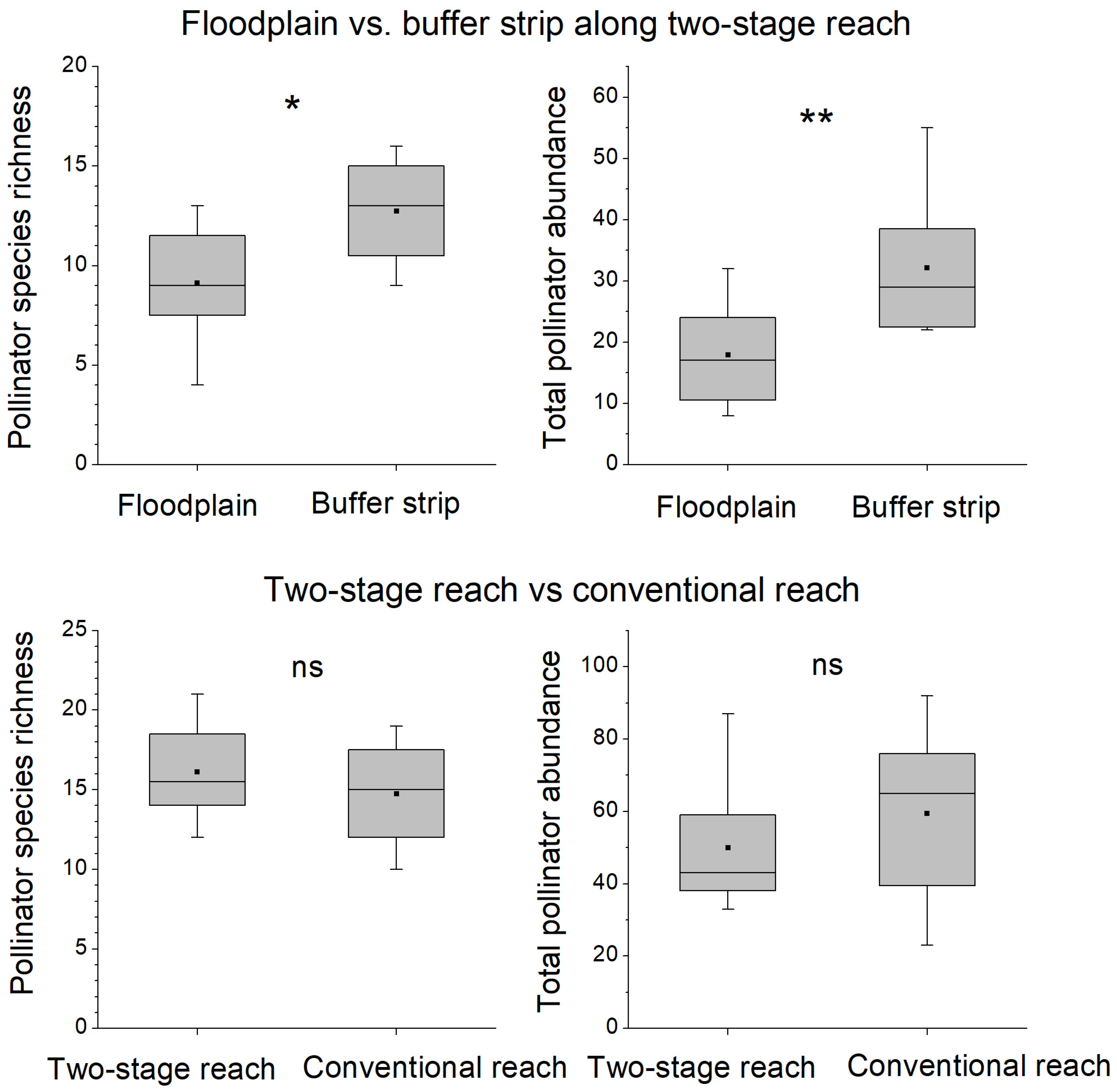
3.2.4. Diversity of Pollinating Insects
3.3. Costs and Monetary Environmental Benefits
3.3.1. Costs at Reach-Scale Pilot Two-Stage Channels
3.3.2. Total Costs and Monetary Environmental Benefits Scaled up to a Larger Catchment
3.4. Current Financing Situation and Bottlenecks in the Agri-Environmental Subsidy Scheme
3.5. Development Needs of Governance to Boost Nature-Based Solutions
4. Discussion
4.1. Potential of Two-Stage Channels for Decreasing the Harmful Hydro-Environmental Impacts of Agriculture
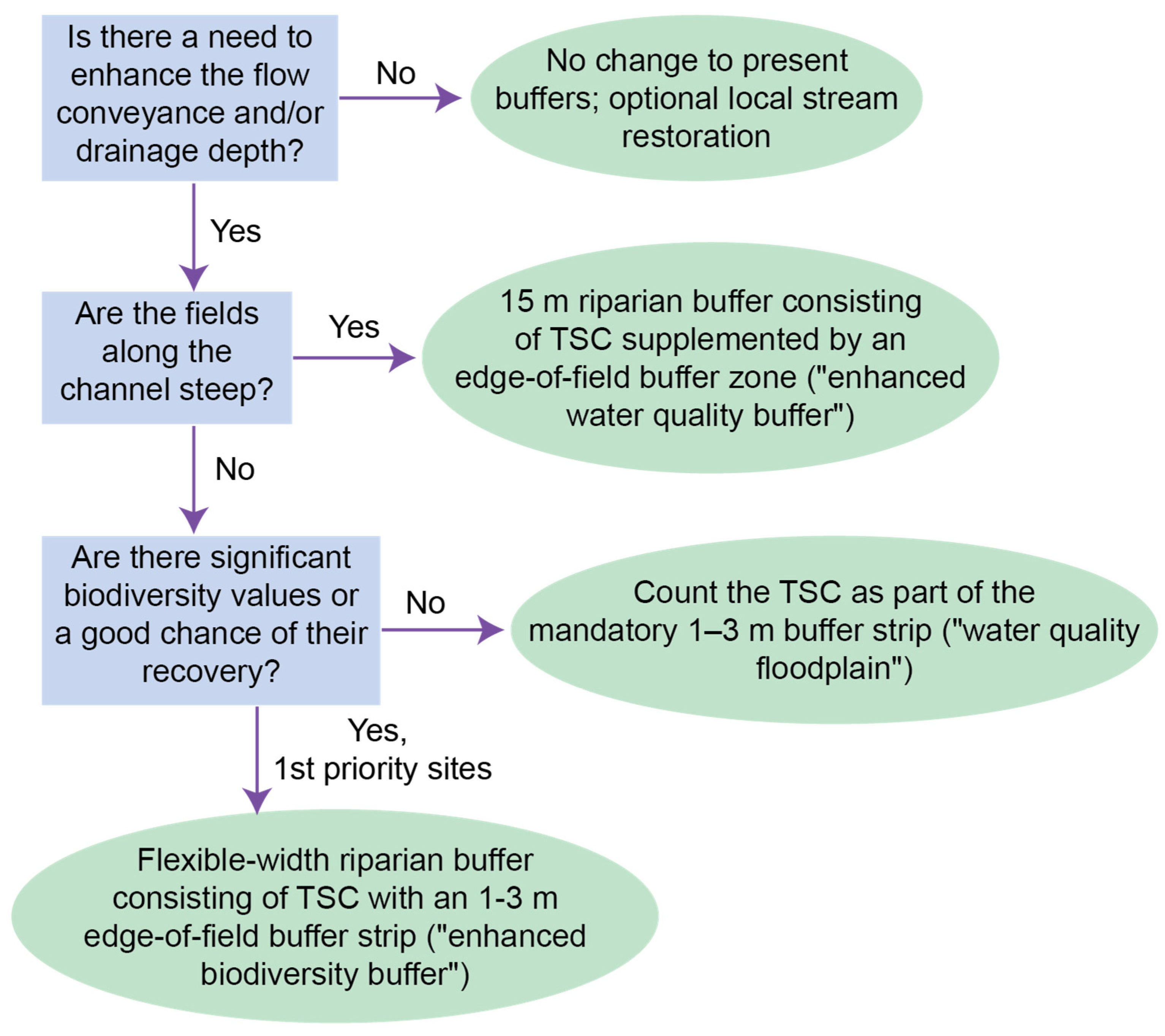
4.2. Proposed Financing Reform Based on Optimal Targeting of Two-Stage Channels and Re-Direction of Public Funding
4.3. Future Research Needs and Capacity Building for Mainstreaming Two-Stage Channels
5. Conclusions
Supplementary Materials
Author Contributions
Funding
Institutional Review Board Statement
Informed Consent Statement
Data Availability Statement
Acknowledgments
Conflicts of Interest
References
- Herzon, I.; Helenius, J. Agricultural drainage ditches, their biological importance and functioning. Biol. Conserv. 2008, 141, 1171–1183. [Google Scholar] [CrossRef]
- Järvenpää, L.; Savolainen, M. (Eds.) Maankuivatuksen ja Kastelun Suunnittelu [Making Plans for Agricultural Drainage and Irrigation], 2nd ed.; Environmental Administration Guidelines 4/2015; Juvenes Print: Tampere, Finland, 2015; ISBN 978-952-11-4517-9. (In Finnish) [Google Scholar]
- Blann, K.L.; Anderson, J.L.; Sands, G.R.; Vondracek, B. Effects of agricultural drainage on aquatic ecosystems: A review. Crit. Rev. Environ. Sci. Technol. 2009, 39, 909–1001. [Google Scholar] [CrossRef]
- Pierce, S.C.; Kröger, R.; Pezeshki, R. Managing artificially drained low-gradient agricultural headwaters for enhanced ecosystem functions. Biology 2012, 1, 794–856. [Google Scholar] [CrossRef] [PubMed]
- Krause, S.; Jacobs, J.; Bronstert, A. Modelling the impacts of land-use and drainage density on the water balance of a lowland–floodplain landscape in northeast Germany. Ecol. Model. 2007, 200, 475–492. [Google Scholar] [CrossRef]
- Gramlich, A.; Stoll, S.; Stamm, C.; Walter, T.; Prasuhn, V. Effects of artificial land drainage on hydrology, nutrient and pesticide fluxes from agricultural fields—A review. Agric. Ecosyst. Environ. 2018, 266, 84–99. [Google Scholar] [CrossRef]
- Rowinski, P.M.; Västilä, K.; Aberle, J.; Järvelä, J.; Kalinowska, M.B. How vegetation can aid in coping with river management challenges: A brief review. Ecohydrol. Hydrobiol. 2018, 18, 345–354. [Google Scholar] [CrossRef] [Green Version]
- Grizzetti, B.; Pistocchi, A.; Liquete, C.; Udias, A.; Bouraoui, F.; van de Bund, W. Human pressures and ecological status of European rivers. Sci. Rep. 2017, 7, 205. [Google Scholar] [CrossRef] [PubMed] [Green Version]
- Bączyk, A.; Wagner, M.; Okruszko, T.; Grygoruk, M. Influence of technical maintenance measures on ecological status of agricultur-al lowland rivers—Systematic review and implications for river management. Sci. Total Environ. 2018, 627, 189–199. [Google Scholar] [CrossRef]
- Grizzetti, B.; Vigiak, O.; Udias, A.; Aloe, A.; Zanni, M.; Bouraoui, F.; Pistocchi, A.; Dorati, C.; Friedland, R.; De Roo, A.; et al. How EU policies could reduce nutrient pollution in European inland and coastal waters. Glob. Environ. Chang. 2021, 69, 102281. [Google Scholar] [CrossRef]
- European Union Water Framework Directive (2000/60/EC). Available online: https://eur-lex.europa.eu/legal-content/EN/TXT/?uri=CELEX:32000L0060 (accessed on 17 August 2021).
- Powell, G.E.; Ward, A.D.; Mecklenburg, D.E.; Jayakaran, A.D. Two-stage channel systems: Part 1, a practical approach for sizing agricultural ditches. J. Soil Water Conserv. 2007, 62, 277–286. [Google Scholar]
- Västilä, K.; Järvelä, J. Environmentally preferable two-stage drainage channels: Considerations for cohesive sediments and conveyance. Int. J. River Basin Manag. 2011, 9, 171–180. [Google Scholar] [CrossRef]
- Krider, L.; Magner, J.; Hansen, B.; Wilson, B.; Kramer, G.; Peterson, J.; Nieber, J. Improvements in fluvial stability associated with two-stage ditch construction in Mower County, Minnesota. J. Am. Water Resour. Assoc. (JAWRA) 2017, 53, 886–902. [Google Scholar] [CrossRef]
- Paradis, A.; Biron, P.M. Integrating hydrogeomorphological concepts in management approaches of lowland agricultural streams: Perspectives, problems and prospects based on case studies in Quebec. Can. Water Resour. J. 2016, 42, 54–69. [Google Scholar] [CrossRef]
- DeZiel, B.; Krider, L.; Hansen, B.; Magner, J.; Wilson, B.; Kramer, G.; Nieber, J. Habitat improvements and fish community response associated with an agricultural two-stage ditch in Mower County, Minnesota. J. Am. Water Resour. Assoc. 2019, 55, 154–188. [Google Scholar] [CrossRef] [Green Version]
- D’Ambrosio, J.L.; Williams, L.R.; Williams, M.G.; Witter, J.D.; Ward, A.D. Geomorphology, habitat, and spatial location influences on fish and macroinvertebrate communities in modified channels of an agriculturally-dominated watershed in Ohio, USA. Ecol. Eng. 2014, 68, 32–46. [Google Scholar] [CrossRef]
- Vargas-Luna, A.; Crosato, A.; Anders, M.; Hoitink, A.J.F.; Keesstra, S.D.; Uijttewaal, W.S.J. Morphodynamic effects of riparian vegetation growth after stream restoration. Earth Surf. Process. Landforms 2018, 43, 1591–1607. [Google Scholar] [CrossRef]
- Geerling, G.W.; Kater, E.; van den Brink, C.; Baptist, M.J.; Ragas, A.M.J.; Smits, A.J.M. Nature rehabilitation by floodplain excavation: The hydraulic effect of 16 years of sedimentation and vegetation succession along the Waal River, NL. Geomorphology 2008, 99, 317–328. [Google Scholar] [CrossRef]
- Caruso, B.S.; Downs, P.W. Rehabilitation and flood management planning in a steep, boulder-bedded stream. Environ. Manag. 2007, 40, 256–271. [Google Scholar] [CrossRef] [PubMed]
- Faust, D.R.; Kroöger, R.; Moore, M.T.; Rush, S.A. Management practices used in agricultural drainage ditches to reduce Gulf of Mexico hypoxia. Bull. Environ. Contam. Toxicol. 2017, 100, 32–40. [Google Scholar] [CrossRef] [PubMed]
- Kalcic, M.; Crumpton, W.; Liu, X.; D’Ambrosio, J.; Ward, A.; Witter, J. Assessment of beyond-the-field nutrient management practices for agricultural crop systems with subsurface drainage. J. Soil Water Conserv. 2018, 73, 62–74. [Google Scholar] [CrossRef] [Green Version]
- Västilä, K.; Järvelä, J.; Koivusalo, H. Flow–vegetation–sediment interaction in a cohesive compound channel. J. Hydraul. Eng. 2016, 142, 04015034. [Google Scholar] [CrossRef] [Green Version]
- Västilä, K.; Järvelä, J. Characterizing natural riparian vegetation for modeling of flow and suspended sediment transport. J. Soils Sediments 2018, 18, 3114–3130. [Google Scholar] [CrossRef] [Green Version]
- EA International. Field Evaluation of Two-Stage Channels Impact on Local Biodiversity and Nutrient Retention Potential; Report Number: 2020:06; 2020; ISBN 978-91-7675-185-5. Available online: https://northsearegion.eu/media/14698/raaaan-two-stage-channels-impact-on-biodiversity-and-nutrient-retention.pdf (accessed on 17 August 2021).
- Ranjan, P.; Witter, J.D. Promoting adoption of two-stage agricultural drainage ditches: A change agent perspective. PLoS ONE 2020, 15, e0229969. [Google Scholar] [CrossRef] [Green Version]
- Roley, S.S.; Tank, J.L.; Tyndall, J.C.; Witter, J.D. How cost-effective are cover crops, wetlands, and two-stage ditches for nitrogen removal in the Mississippi River Basin? Water Resour. Econ. 2016, 15, 43–56. [Google Scholar] [CrossRef] [Green Version]
- Batáry, P.; Dicks, L.V.; Kleijn, D.; Sutherland, W.J. The role of agri-environment schemes in conservation and environmental management. Conserv. Biol. 2015, 29, 1006–1016. [Google Scholar] [CrossRef] [PubMed] [Green Version]
- Kreiling, R.M.; Thoms, M.C.; Richardson, W.B. Beyond the edge: Linking agricultural landscapes, stream networks, and best management practices. J. Environ. Qual. 2017, 47, 42–53. [Google Scholar] [CrossRef]
- Dabney, S.M.; Moore, M.T.; Locke, M.A. Integrated management of in-field, edge-of-field, and after-field buffers. J. Am. Water Resour. Assoc. 2006, 42, 15–24. [Google Scholar] [CrossRef]
- Gene, S.M.; Hoekstra, P.F.; Hannam, C.; White, M.; Truman, C.; Hanson, M.L.; Prosser, R.S. The role of vegetated buffers in agriculture and their regulation across Canada and the United States. J. Environ. Manag. 2019, 243, 12–21. [Google Scholar] [CrossRef] [PubMed]
- Turunen, M. Assessing Water and Sediment Balances in Clayey Agricultural Fields in High-Latitude Conditions. Ph.D. Thesis, Aalto University, Espoo, Finland, 2017. Available online: http://urn.fi/URN:ISBN:978-952-60-7378-1 (accessed on 17 August 2021).
- Piniewski, M.; Tattari, S.; Koskiaho, J.; Olsson, O.; Djodjic, F.; Giełczewski, M.; Marcinkowski, P.; Księżniak, M.; Okruszko, T. How effective are River Basin Management Plans in reaching the nutrient load reduction targets? Ambio 2021, 50, 706–722. [Google Scholar] [CrossRef] [PubMed]
- EEA. Exploring Nature-Based Solutions—The Role of Green Infrastructure in Mitigating the Impacts of Weather- and Climate Change-Related Natural Hazards; EEA Technical Report No 12/2015; European Environment Agency: Copenhagen, Denmark, 2015; ISBN 978-92-9213-693-2. [Google Scholar] [CrossRef]
- EEA. Green Infrastructure and Flood Management Promoting Cost-Efficient Flood Risk Reduction via Green Infrastructure Solutions; European Environment Agency: Copenhagen, Denmark, 2017; ISBN 978-92-9213-894-3. ISSN 1977-8449. [Google Scholar] [CrossRef]
- Häggblom, O.; Härkönen, L.; Joensuu, S.; Keskisarja, V.; Äijö, H. Water Management Guidelines for Agriculture and Forestry; Ministry of Agriculture and Forestry: Helsinki, Finland, 2020; ISBN 978-952-366-186-8. Available online: http://urn.fi/URN:ISBN:978-952-366-186-8 (accessed on 17 August 2021). (In Finnish)
- Haines-Young, R.; Potschin, M.B. Common International Classification of Ecosystem Services (CICES) V5.1 and Guidance on the Application of the Revised Structure. 2018. Available online: https://cices.eu/resources/ (accessed on 17 August 2021).
- Västilä, K.; Järvelä, J.; Jalonen, J. Effect of floodplain vegetation on flow and transport of cohesive particles in an environmental two-stage channel. In Proceedings of the 36th IAHR World Congress, The Hague, The Netherlands, 28 June–3 July 2015; pp. 604–608, ISBN 978-90-824846-0-1. [Google Scholar]
- Västilä, K.; Jilbert, T. Draft Title of the Manuscript: 9-Year Monitoring Reveals Efficient Self-Cleansing and Sedimentary Retention of Nutrients in a Vegetated Two-Stage Channel. Scientific manuscript in preparation.
- US Army Corps of Engineers. HEC-RAS River Analysis System User’s Manual; Version 5.0; U.S. Army Corps of Engineers: Washington, DC, USA, 2016. [Google Scholar]
- Puustinen, M.; Tattari, S.; Koskiaho, J.; Linjama, J. Influence of seasonal and annual hydrological variations on erosion and phosphorus transport from arable areas in Finland. Soil Tillage Res. 2007, 93, 44–55. [Google Scholar] [CrossRef]
- Kämäri, M.; Tarvainen, M.; Kotamäki, N.; Tattari, S. High-frequency measured turbidity as a surrogate for phosphorus in boreal zone rivers: Appropriate options and critical situations. Environ. Monit. Assess. 2020, 192, 366. [Google Scholar] [CrossRef]
- Jarvie, H.P.; Mortimer, R.J.G.; Palmer-Felgate, E.J.; St. Quinton, K.; Harman, S.A.; Carbo, P. Measurement of soluble reactive phosphorus concentration profiles and fluxes in river-bed sediments using DET gel probes. J. Hydrol. 2008, 350, 261–273. [Google Scholar] [CrossRef]
- Geertsema, W.; Sprangers, J.T.C.M. Plant distribution patterns related to species characteristics and spatial and temporal habitat heterogeneity in a network of ditch banks. Plant Ecol. 2002, 162, 91–108. [Google Scholar] [CrossRef]
- Leng, X.; Musters, C.J.M.; de Snoo, G.R. Spatial variation in ditch bank plant species composition at the regional level: The role of environment and dispersal. J. Veg. Sci. 2010, 21, 868–875. [Google Scholar] [CrossRef]
- Pollard, E.; Yates, T. Monitoring Butterflies for Ecology and Conservation; Chapman and Hall: London, UK, 1993. [Google Scholar]
- National Land Survey of Finland. Statistical Information on Real Estate Transactions. 2019. Available online: https://khr.maanmittauslaitos.fi/tilastopalvelu/rest/API/kiinteistokauppojen-tilastopalvelu.html?v=2.0.0#t423g4_x_2019_x_Maakunta (accessed on 17 February 2021).
- Natural Resources Institute Finland. Statistics Database, Yield of the Main Crops. 2020. Available online: http://statdb.luke.fi/PXWeb/pxweb/en/LUKE/LUKE__02%20Maatalous__04%20Tuotanto__14%20Satotilasto/?rxid=dc711a9e-de6d-454b-82c2-74ff79a3a5e0 (accessed on 17 August 2021).
- Hankkija, O. Prices for Crops. 2021. Available online: https://www.hankkija.fi/Maatalous_ja_metsa/viljakauppa/viljamarkkinat-ja-hinnat/Viljan_hintanoteeraukset (accessed on 8 March 2021).
- Hjerppe, T.; Väisänen, S. A practical tool for selecting cost-effective combinations of phosphorus loading mitigation measures in Finnish catchments. J. River Basin Manag. 2015, 13, 2015. [Google Scholar] [CrossRef]
- Southwest Finland ELY Centre. Vuollejokisimpukan Esiintyminen Perniönjoessa, Kiskonjoessa ja Uskelanjoessa. [The Presence of Thick-Shelled River Mussel (Unio crassus) in Rivers Perniönjoki, Kiskonjoki and Uskelanjoki]. 2014. Unpublished Report (reference: 1510013345). (In Finnish) [Google Scholar]
- Decree on the Value of Protected Species by the Ministry of Environment (9/2002). Available online: https://www.finlex.fi/fi/laki/alkup/2002/20020009 (accessed on 17 August 2021). (In Finnish).
- Nature Conservation Act (1096/1996). Available online: https://finlex.fi/en/laki/kaannokset/1996/en19961096 (accessed on 17 August 2021).
- Uusimaa ELY Centre Tulkintaohje Vuollejokisimpukan Lisääntymis- ja Levähdyspaikan Määrittämiseksi ja Turvaamiseksi Vesistötöissä. Interpretation Guide to Determine and Protect Breeding and Resting Places of Unio Crassus. 2010. Available online: https://www.ymparisto.fi/download/noname/%7B39167464-3731-45E8-9A41-FDD8434F2D1E%7D/107401 (accessed on 17 August 2021). (In Finnish).
- Kinnunen, O.; Hjerppe, T.; Väisänen, S. ELY-keskusten Näkökulma Luonnonmukaisten Periaatteiden Toteutumiseen Maatalouden Peruskuivatushankkeissa [ELY Centers’ Perspective on the Implementation of Nature-Based Principles in Agricultural Dredging Projects]. (In Finnish). 2021. Available online: http://hdl.handle.net/10138/328670 (accessed on 17 August 2021).
- Hodaj, A.; Bowling, L.C.; Frankenberger, J.R.; Chaubey, I. Impact of a two-stage ditch on channel water quality. Agric. Water Manag. 2017, 192, 126–137. [Google Scholar] [CrossRef]
- Collins, S.D.; Shukla, S.; Shrestha, N.K. Drainage ditches have sufficient adsorption capacity but inadequate residence time for phosphorus retention in the Everglades. Ecol. Eng. 2016, 92, 218–228. [Google Scholar] [CrossRef] [Green Version]
- Roley, S.S.; Tank, J.L.; Stephen, M.L.; Johnson, L.T.; Beaulieu, J.J.; Witter, J.D. Floodplain restoration enhances denitrification and reach-scale nitrogen removal in an agricultural stream. Ecol. Appl. 2012, 22, 281–297. [Google Scholar] [CrossRef] [PubMed] [Green Version]
- Mahl, U.H.; Tank, J.L.; Roley, S.S.; Davis, R.T. Two-stage ditch floodplains enhance N-removal capacity and reduce turbidity and dissolved p in agricultural streams. J. Am. Water Resour. Assoc. 2015, 51, 923–940. [Google Scholar] [CrossRef]
- Trentman, M.T.; Tank, J.L.; Jones, S.E.; McMillan, S.K.; Royer, T.V. Seasonal evaluation of biotic and abiotic factors suggests phosphorus retention in constructed floodplains in three agricultural streams. Sci. Total Environ. 2020, 729, 138744. [Google Scholar] [CrossRef]
- Davis, R.T.; Tank, J.L.; Mahl, U.H.; Winikoff, S.G.; Roley, S.S. The influence of two-stage ditches with constructed floodplains on water column nutrients and sediments in agricultural streams. J. Am. Water Resour. Assoc. 2015, 51, 941–955. [Google Scholar] [CrossRef]
- Peterson, J.; Wilson, B.N.; Kramer, G. Two-stage ditch assessment using the CONCEPTS model. In ASABE Annual International Meeting; ASABE Paper No.1009158; American Society of Agricultural and Biological Engineers: St. Joseph, MI, USA, 2010. [Google Scholar]
- D’Ambrosio, J.L.; Ward, A.D.; Witter, J.D. Evaluating geomorphic change in constructed two-stage ditches. J. Am. Water Resour. Assoc. 2015, 51, 910–922. [Google Scholar] [CrossRef]
- Hille, S.; Andersen, D.K.; Krnovang, B.; Baattrup-Pedersen, A. Structural and functional characteristics of buffer strip vegetation in an agricultural landscape—High potential for nutrient removal but low potential for plant biodiversity. Sci. Total Environ. 2018, 628–629, 805–814. [Google Scholar] [CrossRef] [PubMed]
- Jormola, J.; Laitinen, L.; Sarvilinna, A. Environmentally friendly drainage practices. In Proceedings of the 10th International Drainage Workshop of ICID Working Group on Drainage, Helsinki/Tallinn, Finland/Estonia, 6–11 July 2008; Helsinki University of Technology, Water Resources Publications: Espoo, Finland, 2008; pp. 259–268. [Google Scholar]
- Kieta, K.A.; Owens, P.N.; Lobb, D.A.; Vanrobaeys, J.S.; Flaten, D.N. Phosphorus dynamics in vegetated buffer strips in cold climates: A review. Environ. Rev. 2017, 2018, 255–272. [Google Scholar] [CrossRef]
- Bai, Y.; Sun, G. The streamwise velocity distribution in a two-stage channel with ice cover. Water Supply 2021. [Google Scholar] [CrossRef]
- Uusheimo, S.; Tulonen, T.; Aalto, S.L.; Arvola, L. Mitigating agricultural nitrogen load with constructed ponds in northern latitudes: A field study on sedimental denitrification rates. Agric. Ecosyst. Environ. 2018, 261, 71–79. [Google Scholar] [CrossRef] [Green Version]
- Riis, T.; Kelly-Quinn, M.; Aguiar, F.C.; Manolaki, P.; Bruno, D.; Bejarano, M.D.; Clerici, N.; Fernandes, M.R.; Franco, J.C.; Pettit, N.; et al. Global overview of ecosystem services provided by riparian vegetation. Bioscience 2020, 70, 501–514. [Google Scholar] [CrossRef]
- Kiczko, A.; Västilä, K.; Kozioł, A.; Kubrak, J.; Kubrak, E.; Krukowski, M. Predicting discharge capacity of vegetated compound channels: Uncertainty and identifiability of one-dimensional process-based models. Hydrol. Earth Syst. Sci. 2020, 24, 4135–4167. [Google Scholar] [CrossRef]
- Christopher, S.F.; Tank, J.L.; Mahl, U.H.; Yen, H.; Arnold, J.G.; Trentman, M.T.; Sowa, S.P.; Royer, T.V. Modeling nutrient removal using watershed-scale implementation of the two-stage ditch. Ecol. Eng. 2017, 108, 358–369. [Google Scholar] [CrossRef]
- Hjerppe, T.; Hämäläinen, L.; Törrönen, J.; Raitanen, H.; Jormola, J. Kuivatustoiminnassa Muuttuneiden Virtavesien Kunnostus Ja hoito (KURVI)—Loppuraportti 31.12.2018. [Rehabilitation and Management of Watercourses That Have Changed During Drainage Operations (The KURVI Project)—Final Report 31.12.2018]; Finnish Environment Institute: Helsinki, Finland, 2018; p. 44. (In Finnish) [Google Scholar]
- Franzén, F.; Dinnétz, P.; Hammer, M. Factors affecting farmers’ willingness to participate in eutrophication mitigation—A case study of preferences for wetland creation in Sweden. Ecol. Econom. 2016, 130, 8–15. [Google Scholar] [CrossRef]
- Act on Support for Drainage Operations (947/1997). Available online: https://www.finlex.fi/fi/laki/ajantasa/1997/1997094 (accessed on 17 August 2021). (In Finnish).
- Blomqvist, M.M.; Vos, P.; Klinkhamer, P.G.L.; Ter Keurs, W.J. Declining plant species richness of grassland ditch banks—Problem of colonisation or extinction? Biol. Conserv. 2003, 109, 391–406. [Google Scholar]
- Kramer, G.; Peterson, J.; Han, J.; Hansen, B.; Magner, J.; Wilson, B.; Nieber, J. Design and construction of an alternative drainage ditch system. Int. J. Hydrol. 2019, 3, 259–268. [Google Scholar] [CrossRef]
- Huttunen, I.; Lehtonen, H.; Huttunen, M.; Piirainen, V.; Korppoo, M.; Veijalainen, N.; Viitasalo, M.; Vehviläinen, B. Effects of climate change and agricultural adaptation on nutrient loading from Finnish catchments to the Baltic Sea. Sci. Total Environ. 2015, 529, 168–181. [Google Scholar] [CrossRef]
- Barnosky, A.D.; Hadly, E.A.; Gonzalez, P.; Head, J.; Polly, P.D.; Lawing, A.M.; Eronen, J.T.; Ackerly, D.D.; Alex, K.; Biber, E.; et al. Merging paleobiology with conservation biology to guide the future of terrestrial ecosystems. Science 2017, 355, eaah4787. [Google Scholar] [CrossRef] [PubMed]
- Brander, L.; Brouwer, R.; Wagtendonk, A. Economic valuation of regulating services provided by wetlands in agricultural landscapes: A meta-analysis. Ecol. Eng. 2013, 56, 89–96. [Google Scholar] [CrossRef]
- Turunen, J.; Elbrecht, V.; Steinke, D.; Aroviita, J. Riparian forests can mitigate warming and ecological degradation of agricultural headwater streams. Freshw. Biol. 2020, 66, 785–798. [Google Scholar] [CrossRef]
- BBOP. Standard on Biodiversity Offsets; Business and Biodiversity Offsets Programme: Washington, DC, USA, 2012; Available online: https://www.forest-trends.org/wp-content/uploads/imported/BBOP_Standard_on_Biodiversity_Offsets_1_Feb_2013.pdf/ (accessed on 17 August 2021).
- Lötjönen, S.; Ollikainen, M.; Kotamäki, N.; Huttunen, M.; Huttunen, I. Nutrient load compensation as a means of maintaining the good ecological status of surface waters. Ecol. Econ. 2021, 188, 107108. [Google Scholar] [CrossRef]
- Pekkonen, M.; Koljonen, S.; Raunio, A.; Kostamo, K.; Soimakallio, S. Ecological Compensations Are Worth Taking into Use; Policy Brief; Finnish Environment Institute: Helsinki, Finland, 2019; ISBN 978-952-11-5100-2. [Google Scholar]
- Lehtoranta, V.; Sarvilinna, A.; Vaisanen, S.; Aroviita, J.; Muotka, T. Public values and preference certainty for stream restoration in forested watersheds in Finland. Water Resourc. Econom. 2017, 17, 56–66. [Google Scholar] [CrossRef]
- Uggeldahl, K.C.; Olsen, S.B. Public preferences for co-benefits of riparian buffer strips in Denmark: An economic valuation study. J. Environ. Manag. 2019, 239, 342–351. [Google Scholar] [CrossRef] [PubMed]
- Amigues, J.P.; Boulatoff, C.; Desaigues, B.; Gauthier, C.; Keith, J.E. The benefits and costs of riparian analysis habitat preservation: A willingness to accept/willingness to pay contingent valuation approach. Ecol. Econom. 2002, 43, 17–31. [Google Scholar] [CrossRef]
- USDA. Two-stage channel design. In National Engineering Handbook; Part 654, Stream Restoration Design; United States Department of Agriculture, Natural Resources Conservation Service: Washington, DC, USA, 2007. [Google Scholar]


| Indicator | Assessment Criteria | Scale of Analysis | Main Methodologies |
|---|---|---|---|
| Benefits through ecosystem services | Adapted CICES 5.1 framework for comparing TSCs and conventional dredging | Boreal and Continental climates | Literature survey supplemented by field investigations and expert judgement (Section 2.2) |
| Water quality | Retention efficiency of suspended sediment and particulate phosphorus | Primary reach-scale pilot site | Field investigations (Section 2.2.1) |
| Drainage and flood mitigation | Water levels at different discharges, channel bed level development | Primary reach-scale pilot site | Field investigations, hydraulic modelling (Section 2.2.1) |
| Biodiversity | Abundance and species richness of plants and pollinating insects | Primary reach-scale pilot site | Field investigations (Section 2.2.2) |
| Costs and financing | Construction and maintenance costs, value of lost field and crops; shares of financing | Primary and supplementary reach-scale pilot sites (n = 6) | Collection of realised and estimated costs and financing (Section 2.3.1) |
| Monetary environmental benefits | Phosphorus retention, conservation of protected species | Catchment scale pilot site | Cost-benefit analysis based on up-scaled costs and additional environmental benefits (Section 2.3.2) |
| Bottlenecks in financing, governance, and capacity | Current CAP-AES, regional and national governance and legislation, knowledge gaps | Finland, generalisable to Boreal and Continental climates | Expert interviews (Section 2.4) |
| Cost Factor | Estimation Method for Two-Stage Channel | Estimation Method for Conventional Dredging |
|---|---|---|
| Realised construction costs and shares of financing | Personal communications with the leaders of the reach-scale pilot sites (Table S1) | No construction costs (channels have been constructed in the past) |
| Maintenance interval | 50 years | 20 years |
| Maintenance costs | Assumed 50% lower than for conventional dredging (2.5 €/m) | 5 €/m (Mikko Ortamala, personal communication, 18 January 2021); realised costs at Uuhikonoja |
| Operation costs | Assumed negligible | Assumed negligible |
| Adjacent land value (lost field area) | Lost field area estimated from channel design plans; region-specific selling prices of 2019 (7800–11,400 €/ha) [47] | No losses in field area |
| Lost value of crops caused by lost field area | Typical crop yield of grains for Southern Finland (4 t/ha) [48]; present national selling price of grains (172 €/t) [49] | No losses in crops |
| Section and Division | Code and Simple Descriptor | Potential Benefits of Two-Stage Channels (TSCs) |
|---|---|---|
| Regulation and Maintenance: Transformation of biochemical or physical inputs to ecosystems | 2.1.1.1 Bio-remediation and filtering of wastes by micro-organisms, algae, plants, and animals 2.1.1.2 Chemical and physical processing of wastes 5.1.1.3 Mediation of waste, toxics, and other nuisances by non-living processes | More vegetated surfaces trapping more suspended sediment (this study (Section 3.2.2), [23,56]) and particulate phosphorus (this study (Section 3.2.2), [21,56]) from the fields during floods Conventionally dredged streams remove little nitrogen [57], while floodplains enhance nitrogen removal through intensified denitrification [22,58,59] Conventionally dredged stream beds retain little dissolved phosphorus [57], while floodplains retain more dissolved phosphorus [56,60] Decreased turbidity at high flows [59,61] Vegetative uptake of nutrients higher in TSCs due to larger vegetative biomass EXP |
| Regulation and Maintenance: Regulation of physical, chemical, and biological conditions | 2.2.1.1 Controlling or preventing soil loss | Protection of bank erosion since the banks are lower and the floodplain banks do not collapse into the low-flow channel EXP |
| 2.2.1.3 Regulating the flows of water in our environment | Long-term functioning of drainage since the TSC bed is self-cleansing and seldom needs maintenance (this study (Section 3.2.1 and Section 3.3.1), [12,62]) Likely long-term reduction of flood risks in the fields with less maintenance needs [12,63] Higher baseflow and dry-season water levels due to narrower low-flow channel EXP | |
| 2.2.2.1 Pollinating our fruit trees and other plants | Floodplains offer additional habitat for pollinators and may be important nectar sources in dry years (This study (Section 3.2.4)) | |
| 2.2.2.3 Providing habitats for wild plants and animals that can be useful to us | Floodplain increases plant biodiversity, particularly the number of wetland species (this study (Section 3.2.3), [64]) Larger fish diversity [16] Support for protected fish species through more natural-like main channel geometry and flow conditions allowing habitat restoration [65] Macroinvertebrate communities likely benefit from improved connectivity to floodplain [17] | |
| Cultural: Direct (or indirect) interactions with living systems that depend on (or do not require) presence in the environmental setting | 3.1.1.2 Watching plants and animals where they live; using nature to destress | Landscape and recreational benefits for local residents through the more variable landscapes EXP |
| 3.1.2.1 Researching nature | Allows increasing knowledge about the biophysical characteristics or qualities of species or ecosystems associated with nature-based solutions for agricultural or riverine water management EXP | |
| 3.2.2.2 The things in nature that we want future generations to enjoy or use | Non-use values from preserving endangered species, habitats, and agricultural landscapes EXP |
| Variable | Units/Unit Cost | Conventional Dredging | Two-Stage Channel Design |
|---|---|---|---|
| Project life | years | 60 | |
| Channel length | km | 14.8 | |
| Maintenance interval | years | 20 | 50 |
| Maintenance costs | €5/€2.5 per channel metre | −222,000 | −44,000 |
| Construction costs | €0/€21.2 per channel metre | 0 | −314,000 |
| Adjacent land price | €0/€3.6 per channel metre | 0 | −53,000 |
| Lost crop value | €0/€0.25 per channel metre | 0 | −223,000 |
| Environmental benefits for biodiversity | €50 per Unio crassus mussel | 0 | 594,000 |
| Environmental benefits for water quality | €249 per phosphorus kg | 0 | 951,000 |
| Net costs in 60 years | € | −222,000 | 910,000 |
| Equivalent annual net cost (EAC) | € per year | −1200 | 7400 |
| Associated Cost Factor | Costs (€) of Conventional Dredging | Costs (€) of Two-Stage Channel (TSC) Design | Notes | |
|---|---|---|---|---|
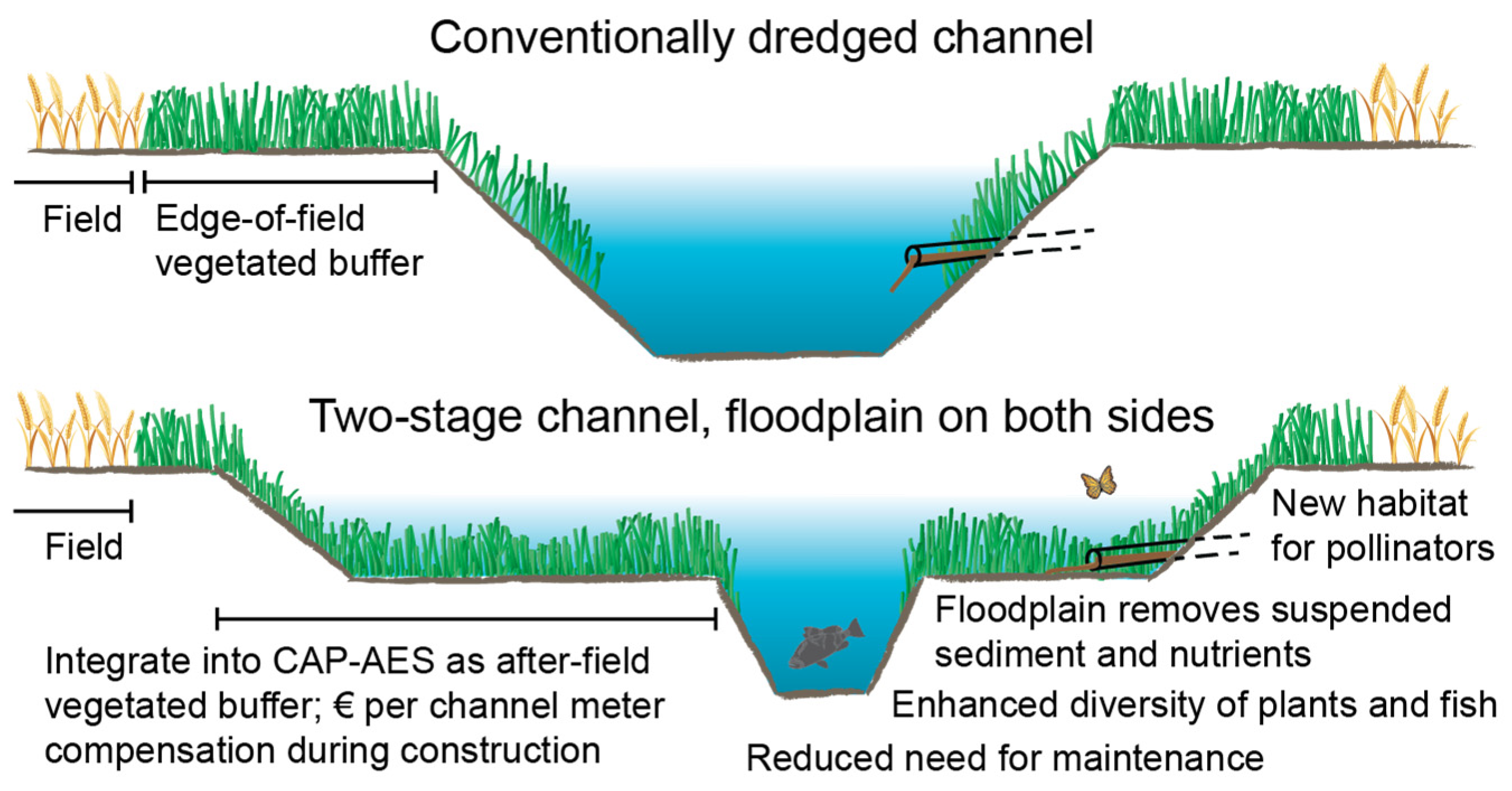
| Maintenance costs | −15,000 | −3000 | Lost crop value computed assuming the proposed CAP-AES reform (3 m of TSC width replaces the required edge-of-field buffer strips; Figure 5 and Figure 6) | |
| Construction costs | - | −21,200 | ||
| Adjacent land value | - | −3600 | ||
| Lost crop value | - | −2800 | ||
| Total costs | −15,000 | −30,600 | ||
| Difference in total costs | −15,600 | |||
| Benefits | Rationale for paying | Payment (€) | Notes | |
| Well-functioning drainage and flood mitigation | Farmers pay the costs for ensuring drainage and flow conveyance, equaling the estimated costs of conventional dredging | −15,000 | The total cost partitioning can be realized through public funding covering 74% of TSC construction costs | |
| Improved water quality and biodiversity | Public funding covers the difference in total costs as the additional benefits are collective 1 | −15,600 | ||
Publisher’s Note: MDPI stays neutral with regard to jurisdictional claims in published maps and institutional affiliations. |
© 2021 by the authors. Licensee MDPI, Basel, Switzerland. This article is an open access article distributed under the terms and conditions of the Creative Commons Attribution (CC BY) license (https://creativecommons.org/licenses/by/4.0/).
Share and Cite
Västilä, K.; Väisänen, S.; Koskiaho, J.; Lehtoranta, V.; Karttunen, K.; Kuussaari, M.; Järvelä, J.; Koikkalainen, K. Agricultural Water Management Using Two-Stage Channels: Performance and Policy Recommendations Based on Northern European Experiences. Sustainability 2021, 13, 9349. https://0-doi-org.brum.beds.ac.uk/10.3390/su13169349
Västilä K, Väisänen S, Koskiaho J, Lehtoranta V, Karttunen K, Kuussaari M, Järvelä J, Koikkalainen K. Agricultural Water Management Using Two-Stage Channels: Performance and Policy Recommendations Based on Northern European Experiences. Sustainability. 2021; 13(16):9349. https://0-doi-org.brum.beds.ac.uk/10.3390/su13169349
Chicago/Turabian StyleVästilä, Kaisa, Sari Väisänen, Jari Koskiaho, Virpi Lehtoranta, Krister Karttunen, Mikko Kuussaari, Juha Järvelä, and Kauko Koikkalainen. 2021. "Agricultural Water Management Using Two-Stage Channels: Performance and Policy Recommendations Based on Northern European Experiences" Sustainability 13, no. 16: 9349. https://0-doi-org.brum.beds.ac.uk/10.3390/su13169349