1. Introduction
Public open spaces are the most critical areas of modern cities striving for dynamic development. The growing problems faced by these cities make them more difficult. The uncontrolled urban sprawl accompanied by an inefficient transport system is the most severe threat. The most significant worth of a modern urban center is its identity, and chaotic development is a cause of its disappearance. The culture of a place and its history are timeless values that distinguish a city from others.
Most often, public open spaces are the elements that shape the individual character of a city. They concentrate on essential functions and, at the same time, influence its image. The elements of public open spaces, composition, configuration, and interactions between them, together form the urban matrix [
1]. This paper presents an analysis of the development of an urban matrix in a medium-sized city—Nowy Sącz, Poland. These analyses enabled us to observe changes in these spaces’ development, management, functioning, and the town itself.
Nowy Sącz can be considered a growth center that influences the socio-economic activity within its borders and neighboring areas. It is the third most important city in the Malopolska region in terms of scale of influence, after Krakow and Tarnow. It concentrates in its range a functional area at the supra-local level, with almost 300,000 residents. The tourist potential is based on the high natural assets of the Beskids Mountains, and the Dunajec and Poprad Valleys [
2,
3].
Nowy Sącz, which is currently a medium-sized town [
4], is one of the centers organizing social and economic activity outside the influence of the largest agglomeration of Kraków—the capital of the voivodeship. Its position directly influences the development of hinterland and rural areas, including marginalized problem areas: the activation of rural regions is conditioned by implementing more effective support mechanisms. The historically shaped weakness of the hinterland area’s infrastructure limits the possibilities of faster development and, at the same time, the ability to accept development impulses coming from the city.
Nowy Sącz, as a multifunctional center with a diversified economic structure, aspires to become a local activity center due to its strong position in the region. It results from a significant demographic potential, the role of a center of employment concentration (satisfying the needs of both the town’s and region’s inhabitants), a large number of higher-level services, and the highest civic activity in the province. The advantage of Nowy Sącz is, therefore, its above-average development potential, especially in the broadly understood services and trade sectors [
2,
3]. The insufficient intensity of transport connections in the functional area of Nowy Sącz, however, prevents the city’s development potential and operational area on the supra-local level to be fully released [
4].
The choice of medium-size cities for comprehensive support with the development policy is connected to the fact that they play a significant stabilizing role in the polycentric settlement system [
5,
6]. The proper formation and functioning of that system positively influences territorial cohesion, reduces development disproportions and tendencies for excessive concentration, lowers activity costs, increases the probability of synergy effects, weakens negative feedback, and enables complementary network cooperation [
7,
8]. Polycentric systems are, therefore, more competitive and efficient [
9,
10]. Of course, Nowy Sącz, as a developing city, experiences numerous problems: uncontrolled urban sprawl; an inefficient public transport system; environmental pollution; the threat of mountain floods; and emigration [
2].
The space syntax method was used to confirm the hypothesis that Nowy Sącz can be perceived as a growth center. It determines the strengths and weaknesses of the city. The space syntax method is used by many researchers. The state of the research concerning the problems addressed in this article is presented.
The issue of participation of models and simulations in urban design and strategic planning in the context of space syntax was raised by Yamu and Voigt (2011) [
11]. The authors described opportunities and facilitators for gaining insight into previously inaccessible parameters, supporting raising awareness among audiences and decision-makers. For example, they described research for the Masterplan on Ljubljana (a large city with 290,000 inhabitants).
Regarding the use of space syntax in the current practice of historical urbanism research, Griffiths (2012) [
12] and Griffiths and Palaiologou (2019) [
13] stand out. They identified possible future fields of research, explored heritage issues, and understood the role of spatial configuration in the context of urban heritage studies. They brought an integrative approach, situating heritage in historical and contemporary spatial arrangements. They introduced critical reflection and a division into conservation areas, street-scale areas, and more significant spatial cultures.
Using the star model, a reading of development typologies and planning scales, and the socio-cultural and microeconomic priorities that constitute impulses for change based on syntactic properties, was presented in Friesen’s (2017) [
14] article. He compared two Canadian cities and contrasted syntactic analyses with a brief historical and ethnographic study of both places.
For an analytical approach to ancient city plans, an interpretation of archival materials, a methodology demonstrated through examples of nineteenth-century urban history research, and an explanation of how theory and techniques inherently designed to study architecture contribute to the study of urban and community history, see Griffiths and Vaughan (2020) [
15].
The added value of this paper, and the need for the study, is evidenced by the fact that so far, in Poland, space syntax has been mainly the subject of theoretical research by the academic community [
16], especially in the context of accessibility, with studies in large cities (with over 300,000 up to 700,000 inhabitants) such as Gdansk [
17], Krakow [
18], Wroclaw [
19], or Lublin [
20]. In addition, thus far in Poland, there has been no space syntax research on the history of 19th- and 20th-century urban planning. The issue of changes in the values of space syntax indicators concerning historical stages of urban development, especially in medium-sized cities, has also not been addressed (research gap). The current study extended the existing literature in the following way: the authors did not focus on analyzing preservation guidelines. Nevertheless, they made an extensive evaluation of historical materials. Moreover, they compared the axial structure and centrality of the layouts of the same city, but at different stages of its development, observing the transformations occurring over 200 years. Individual changes included so far in written studies by historians and art historians were presented in graphic form, taking into account urban indicators and issues of spatial configuration. In addition, the subject of the study was a medium-sized urban organism, where specific processes are much more visible and more accessible to abstract.
The study aimed to achieve the expected outcomes:
Construction of model solutions and urban matrix typologies of Nowy Sącz;
Presentation of the model logic;
Comparison of simulation results with reality and historical knowledge (academic and pragmatic approach);
Defining guidelines for future development of the city, based on research results
The application’s goal was to explain the processes and popularize the knowledge with the help of clear visualization in space syntax visualizations [
11].
This article is divided into six parts. First, following the introduction, in
Section 2, we give the overview of methods and techniques that have been incorporated and provide datasets sources. Secondly, in
Section 3, we describe the political background and civilizing influences to changes in the settlement structure and formation of the modern city of Nowy Sącz, Poland. Thirdly, under space syntax results in
Section 4, we apply and interpret the case study results in consequent time frames. Then, in
Section 5, we discuss limitations and possible further research, briefly introducing the current and potential Nowy Sącz’s developmental issues. Finally, in
Section 6, we conclude the consolidation of the obtained results and suggest application activities, mainly of educational and informational nature.
2. Materials and Methods
The research method of urban analysis based on space syntax was adopted in this study. It has an interdisciplinary character and provides an opportunity for a broader perspective on assessing the existing conditions and planned changes. The analysis dealt with the issues of urban development directions, city typologies, traffic patterns, and the location of central foci [
15,
21]. In climate change, the space syntax allows defining how spatial parameters can support or limit balanced urban transformation and sustainable mobility. Therefore, an analysis of historical maps was undertaken.
Space syntax analysis of historical maps enables the understanding of urban growth and development [
15]. The resulting characterization of urban streets can be used to make and test hypotheses about urban movement in the past, points of convergence, and patterns of socio-economic activity.
Another research technique employed, Star Model (Star Chart), is a technique for viewing the city in terms of normalized angular choice (NAChoice) and normalized angular integration (NAIntegration) simultaneously, allowing the examination of what these variables mean in the context of urban spatial structure. The Star Model technique and comparisons of NACh and NAIn are typically used when comparing different urban organisms. A somewhat different and engaging approach is to compare Nowy Sącz throughout history—a medieval city, then at the dawn of the industrial revolution, and finally, set in the current conditions and ongoing transformation processes.
The theoretical model of the city’s spatial structure is a research procedure that allows one to read the existing structures and identify the city’s urban form and evaluate its potential [
11,
22].
The different thematic layers of the model and the material (visible city) also concern the relations and spatial policies (logical city). They also allow the identification and description of values—including economic importance and defining patterns of private-sector behavior—mobility, and locational behavior (invisible city). These layers are set in specific time horizons (the fourth dimension—time) [
23].
The model adopted in the study describes the layers:
Relationships—links between structural elements of urban matter (physical elements): functional, compositional, and logical connections between spatial components and systems;
Behavioral patterns—mobility, investment decisions, social participation.
The simulation method involves creating a dynamic system model that can be manipulated in time and space. A computer simulation study is a research and design tool developed very intensively over the past 30 years [
21,
24]. In design processes, the visual quality and compatibility of proposed solutions within the urban context are checked. On the other hand, in historical urban studies, different phases of the city’s development have been recreated by computers and reconstructed based on plans, drawings, or descriptions left behind. Through simulation and modeling, knowledge is created by better understanding the behavior of a complex system such as an urban organism. During the research, the data analysis moved from descriptive (description) to qualitative (evaluation) [
24].
The historical analysis of the city made it possible to identify the different phases of its development, along with the accompanying spatial conditions. The following data sources were used: the archival topographic map of Galicia from 1779 to 1783, the archival city plan Uebersichtsplan Neu-Sandez from 1917, and the archival city plan from 1933. The current data were taken from the website of the Municipal Road Administration in Nowy Sącz. Substantive support is found in publicly available, cited studies and analyses of the Central Statistical Office, the Institute of Geography and Spatial Management, the Institute of Public Affairs of the Jagiellonian University in Krakow, the Małopolskie Regional Development Observatory (MORR) in Krakow, the Marshal’s Office in Krakow, and the Municipality of Nowy Sącz.
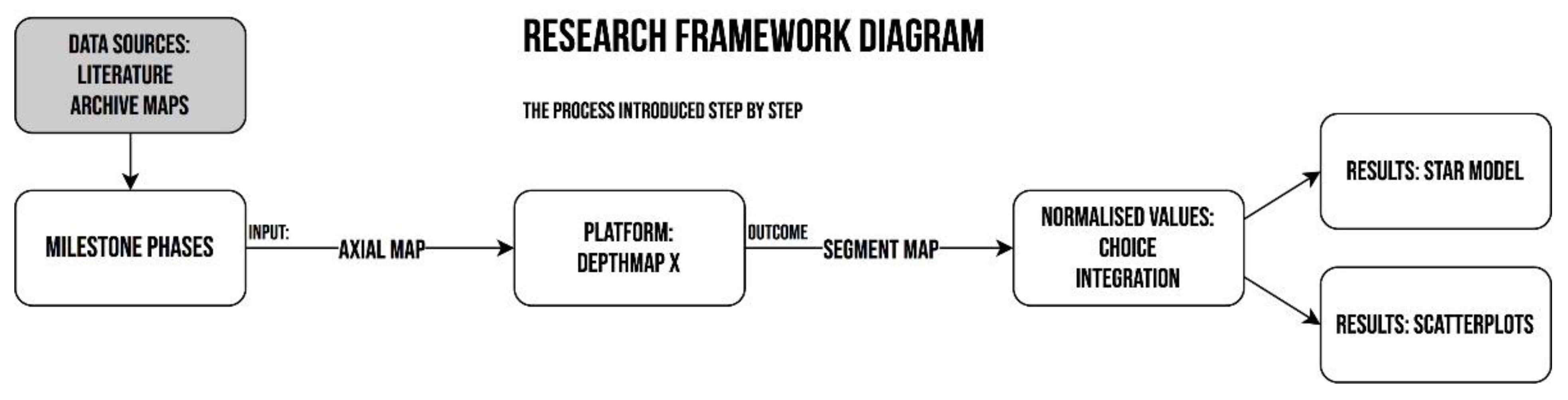
The data were entered in an Axial Map for each time frame. The DepthMap X platform was used to obtain the results. The space syntax analysis process step by step is presented in
Figure 1.
4. Space Syntax Results
The study used space syntax theories and methods to examine the socio-cultural dimensions embedded in spatial systems of historical significance [
15].
The study was based on the habitual—known from the source literature, historical accounts, and observations—foci of urban activity of a centralizing character and attractors generating traffic. These were at various stages of city development:
- -
Public buildings (temples, administrative centers, i.e., the city hall and railroad station);
- -
Public spaces (market, market squares, shopping streets, and city parks);
- -
Structures of former colonist settlements around the city;
- -
Or, finally, entire areas (the industrial zone of the railroad workshops).
Axial maps of the street network were drawn from current and historical city plans. Integration and Choice variables were measured for each stage of the city’s spatial development. It is assumed that Integration represents the potential for space to “to-movement,” which can be understood in terms of movement and flow through the city as a destination decision made at the point of departure. In contrast, Choice represents the potential of space for “through-movement,” which corresponds to the choice of route, i.e., the sequence of urban spaces through which one must pass [
22]. Angular Choice analysis depicts the urban streets’ hierarchy. The data are included in
Table 1.
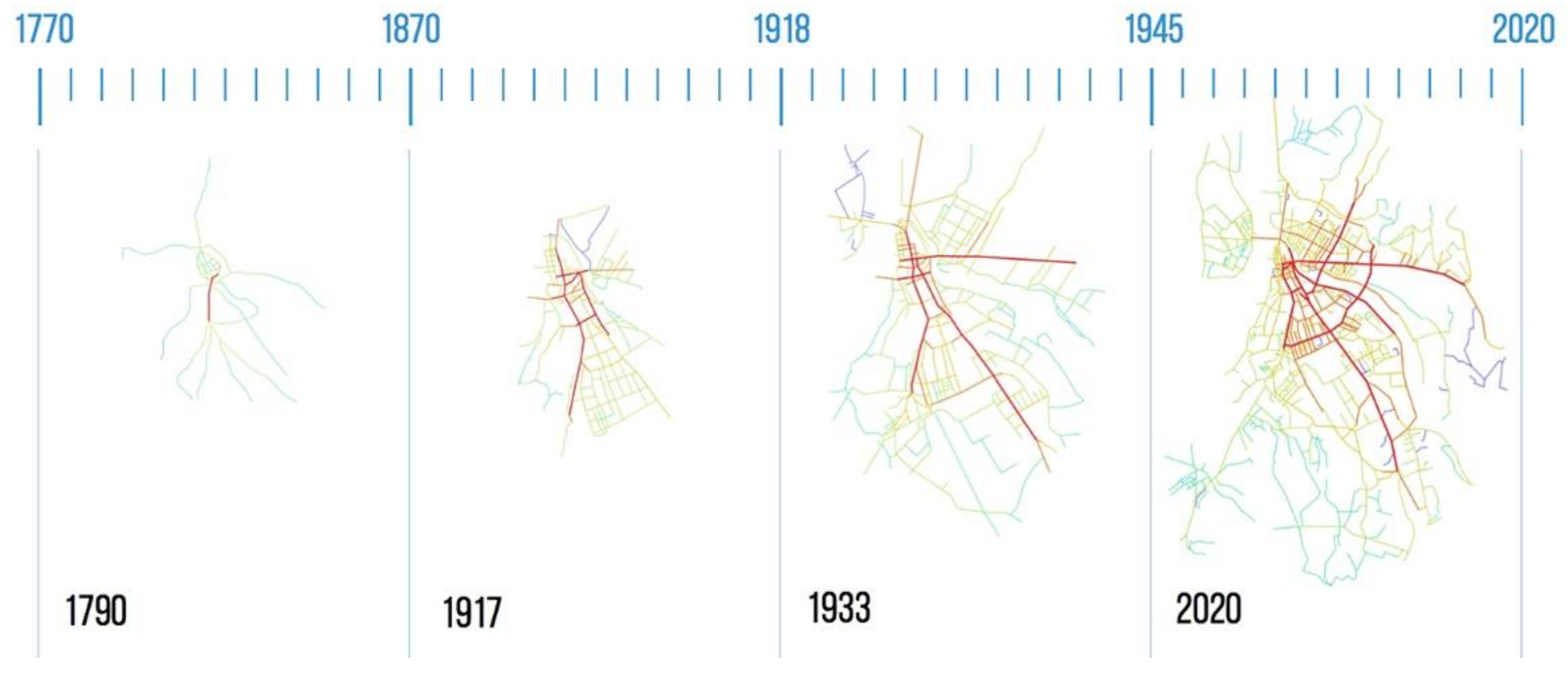
As mentioned above, the 18th-century merchant route along the river valley gave rise to several modern city streets.
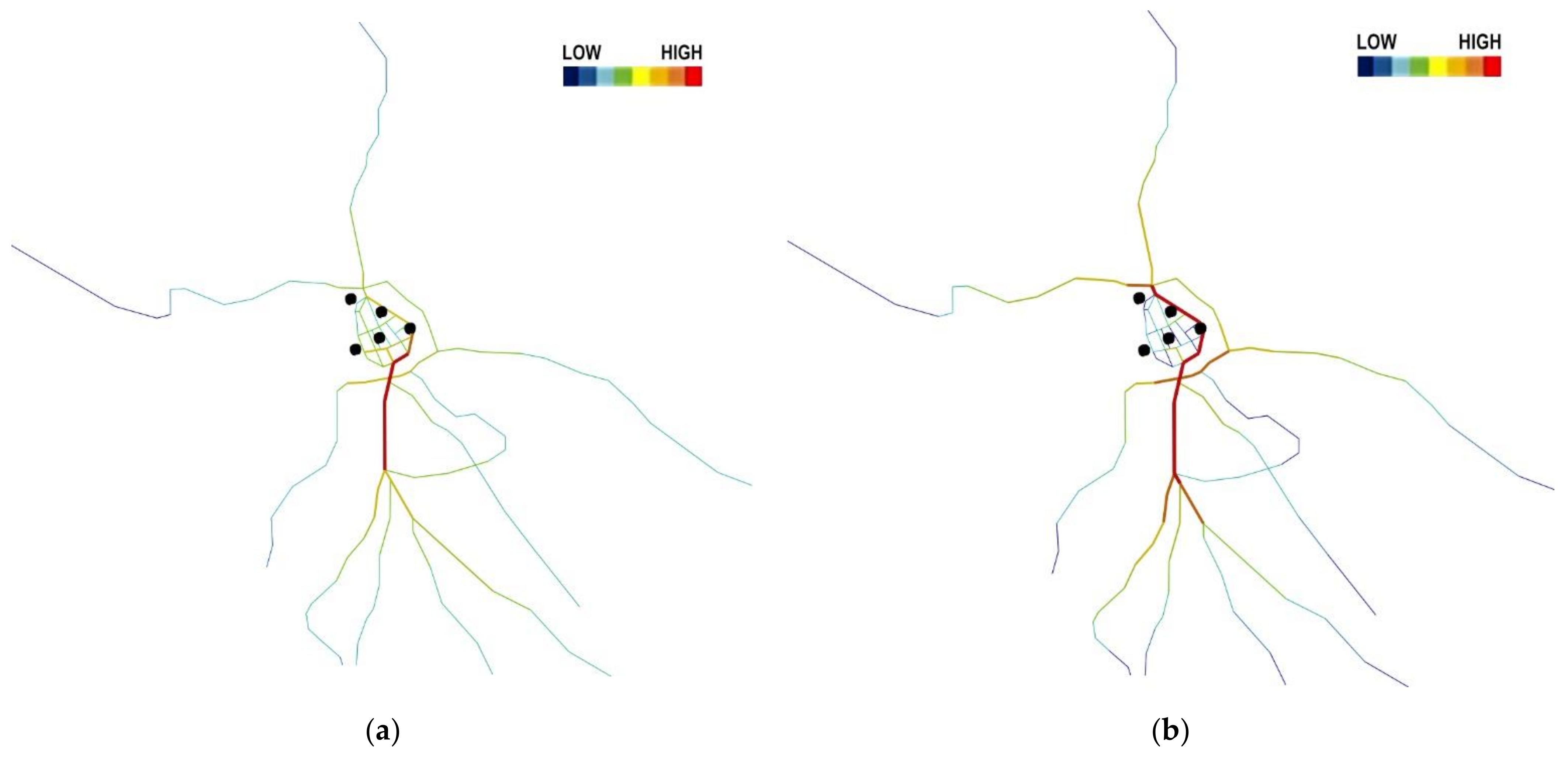
Figure 9 shows the graphical results of the DepthMap X analysis. The red color indicates the segments with high values and potential (and the blue color indicates those with the lowest). The results indicate a high degree of integration of the commercial road with the entire network. This is due to the fact that it was the central axis of the system.
The railroad line became an important city-creating factor. An impressive monumental artery connects the historic city to the railroad station. The survey results shown in
Figure 10 confirmed that this was an important direction. However, the artery itself was less integrated compared to the two streets parallel to it. The one on the eastern side was a trace of an old merchant route. It additionally connected the newly established railroad workers’ colony. Based on this new development axis, a modern railroad workers’ colony was established, in line with the garden city concept.
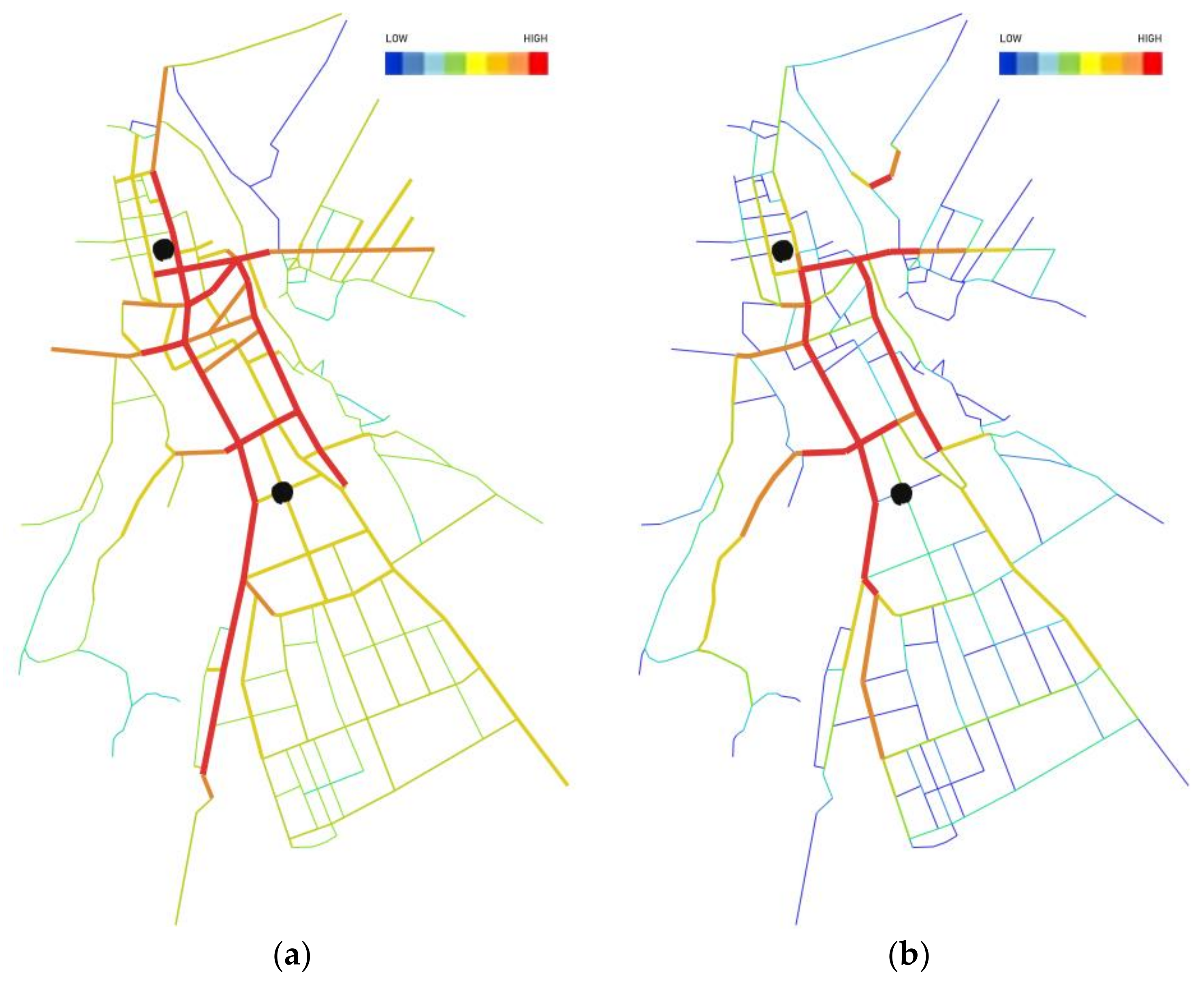
Further spatial development was based on incorporating the areas of the neighboring communes, in the post-war period—by building large multi-family housing complexes. The results of the study of this stage of development are shown in
Figure 11. In addition to the two strongly integrated axes, continuing the existing north–south gravitational system, another axis connects the growing suburbs from the east.
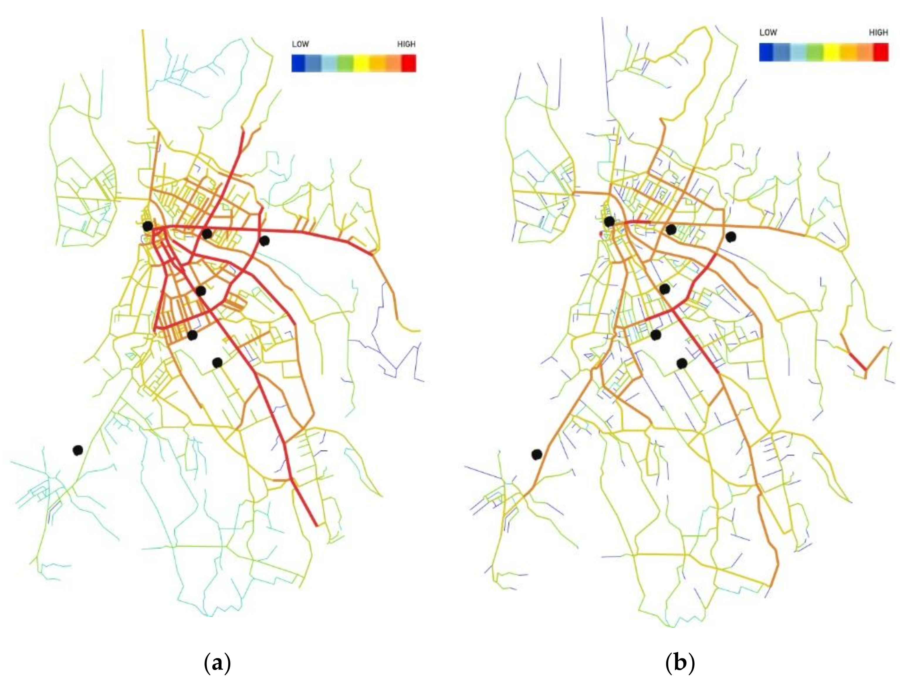
Currently (2021), the strongly integrated axes of historical development are still valid. The result of the study for the current state is shown in
Figure 12: a former commercial tract, an artery connecting the city center to the railroad station, and a connector of the eastern suburbs. The analysis of the existing state shows that one more strongly integrated street was added—a small ring road, connecting the quadrant of the suburbs.
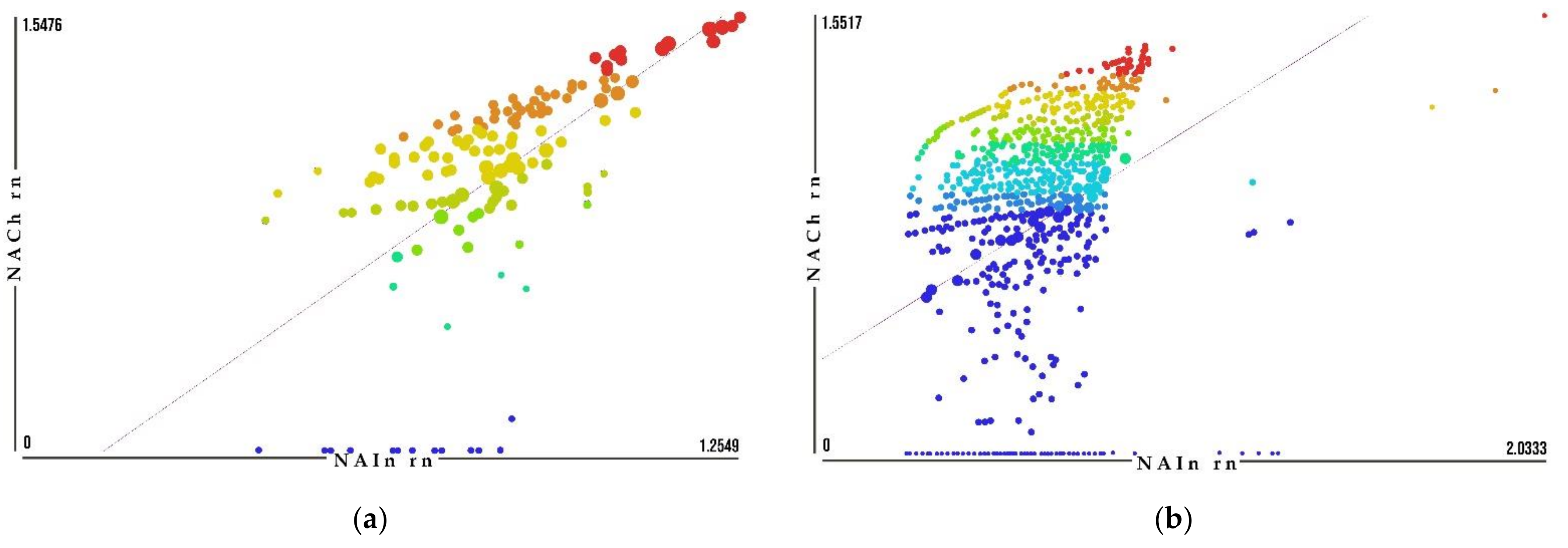
Scatter plots, also called a correlation matrix, were generated with the help of the DepthMap X program. They show the relationship between the values of normalized angular integration (NAIn) and the values of normalized angular choice (NACh). A radius of
n (infinite) was assumed for all variables. Both Integration and Choice take into account the centrality attribute of the structure. There are a few unusual cases, the so-called outliers. The plot included in
Figure 13a shows little scatter and significant agreement between the two coefficients, and there is a strong correlation that defines a higher use of space and movement of people in public space. The plot in
Figure 13b shows significantly lower correlation.
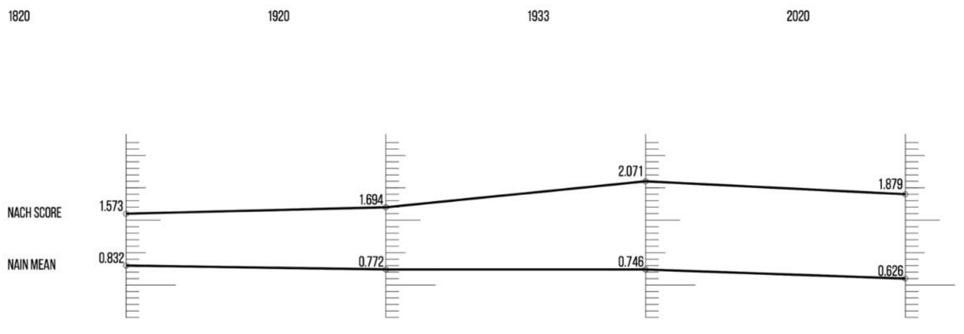
The generated values of the NAChoice and NAIntegration variables are presented in
Table 2. The comparison of values for particular stages of Nowy Sącz’s development and the calculation of the so-called NACh result (which is the product of the maximum and average value) are presented in
Table 3.
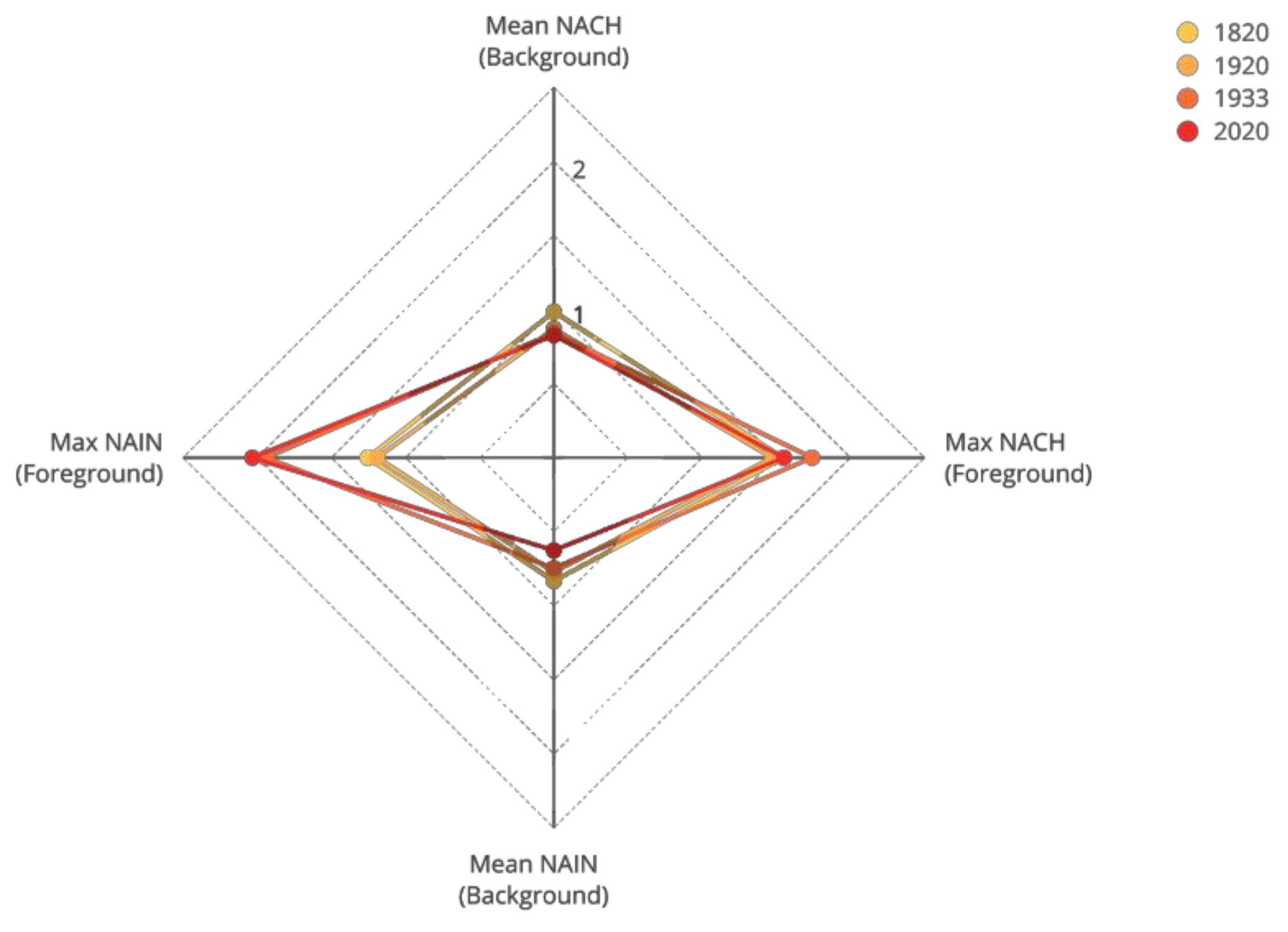
The Star Model graph for Nowy Sącz is shown in
Figure 14. The high and low points on the vertical axis are the average NAChoice (high) and average NAintegration (low) for each of the city’s development stages. The left and right points on the horizontal axis are their maximum NAIntegration (left) and maximum NAChoice (right). Each measure is a standard score varying around 0, with a negative minimum in the middle and a positive maximum at the extreme.
The Foreground Network is the part of the city streets’ structure driven by microeco-nomic factors, linking centers. It benefits from maximized flow and movement. The Back-ground Network, the development of which is supported by socio-cultural factors, is reflected in the structure of the residential environment. Thus, average and maximum NAIntegration show the ease of access in the foreground (maximum) and background (average) networks in the usual syntactic sense. In contrast, average and maximum NA-Choice index the degree of structure in the system: average NAChoice is the degree to which the Background Network forms a continuous grid with direct connections rather than broken into separate subareas. Maximum NAChoice represents the degree to which the Foreground Network structures the system through deformations and grid breaks [
14].
Low average NAIN = socio-cultural priorities
High average NAIN = microeconomic priorities
NACh result (NACh Score) = maximum NACh/average NACh
Low NACh Score = planning from local to global
High NACh Score = planning from global to local
With this simple comparison, we obtain a picture of the developmental changes in the city structure, shown graphically in
Figure 15.
From the beginning of the studied period to the present day, there has been a slight but steady decrease in the mean NAIn index. This indicates a shift in priorities from microeconomic to socio-cultural factors.
On the other hand, the NACh result indicates slight fluctuations that there is now—especially since the middle of the 20th-century—a tendency to plan from a global to a local scale. This indicates the late 20th century’s priority planning framing of the “city for the car.” In contrast, initially and for nearly 200 years, it was planning from the local to the global scale.
5. Discussion
Urban analysis gives a general picture of the study area. Weighing all the results will form the basis of the future development model and the direction of further research. As stiff action plans often cannot be put into practice, due to many circumstances beyond the control of planners, the construction of a reference model was adopted as a general strategic objective, providing orientation for all future stages of development [
23]. The model based on the analysis results was developed as descriptive, allowing the identification of past and future changes based on the trends studied; and it is exploratory, examining the factors that gave impetus to past changes.
The space syntax method was used to analyze individual aspects, understanding that they provide a general explanation of the city as a phenomenon. The smaller the area considered, the more precisely it can be described. It is possible to use this method to explain phenomena that are outside the structure of perception, or that are not perceptible by the senses, such as a qualitative assessment of past planning decisions and their effectiveness decades later.
Space syntax analysis provides a link between tangible and intangible aspects of spatial culture. Understanding the role of spatial configuration in reproducing spatio-temporal events, facilitated by a graphically legible form, allows us to move away from the traditional typology of the built environment, defined only in terms of stylistic periodization [
15]. In the context of urban heritage studies, this means looking at the built environment as an element of emerging arrangements of social spaces, which indeed completes the research gap and the emerging picture of urban studies of past centuries. It is also the first approach to analyze the spatial development of Nowy Sącz using the space syntax method.
An urban scientific analysis is based on the evaluation and interpretation of specific values. The resulting measurements were interpreted by comparing them with measurements from other time frames in the same area. The degree of generalization of the data makes it impossible to scientifically investigate the interaction of all active values in urban space. However, individual aspects can be accurately described, as the model’s accurate measurements and relative weights are available. If we were to point out the study’s limitations, the space syntax method was criticized for the absence of third-dimension data and its failure to consider attractors, such as urban nodes, anchor buildings, or public transportation hubs. Another well-known limitation that can distort space syntax results is the lack of contextual knowledge. We have tried to overcome this issue by relying on in-depth historical analysis as part of the research process.
The existing transportation and traffic organization system are among the most significant barriers to transforming and making the city center more attractive. Finally developed in the 19th century, the transportation system is very “rigid” due to topographical reasons. Relatively high and steep escarpments surrounding the old city complex from the east, north, and west, and both rivers, significantly hampered and still pose a significant technical and economic problem in transforming this system more freely [
2,
31].
Despite the construction of a thoroughfare in the form of the Obroncow Narwiku Boulevard, which was supposed to take over the majority of the city’s long-distance traffic, too much of it still passes through the Market Square and the streets diverging from it [
31,
32]. In addition, the poor street network on the western side of the city results in the limited success of attempts to relieve this traffic. On the other hand, public pressure and lobbying by the interested parties have so far effectively impeded almost all attempts to move traffic out of the immediate Old Town area, or to organize it in such a way as to calm it significantly [
31]. The exponential growth of automobile traffic, accompanied by an increased demand for stopovers imposed on the limited transportation space, displaces or significantly limits other types of traffic: pedestrian, and increasingly popular cycling [
2,
3,
31].
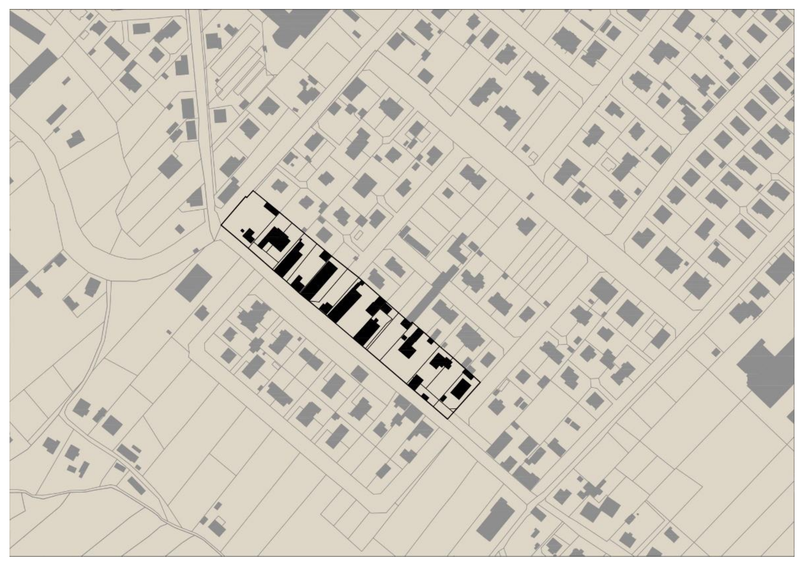
The elements of the urban matrix model that give the impact—the distribution of urban activities—can be classified as urban activity corridors. The reference is made to linear spatial development elements, located along with significant flow directions. In other words, they are elements of the city’s transport infrastructure (roads and streets) with accompanying buildings. Urban corridors play an essential role in integrating the city’s spatial structure. The existing layout of urban corridors is built from several overlapping systems that are described in the aforementioned, individual development phases.
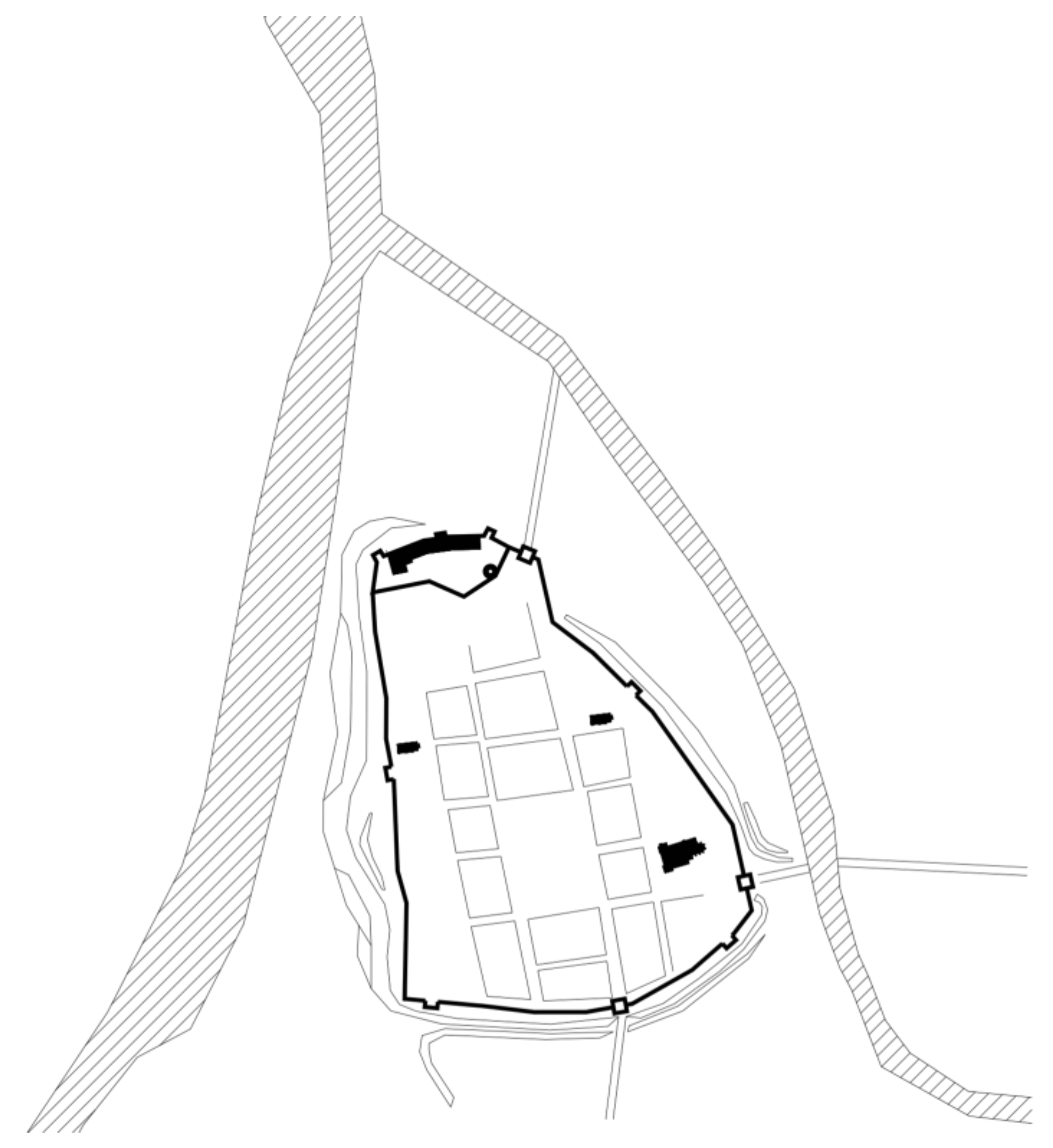
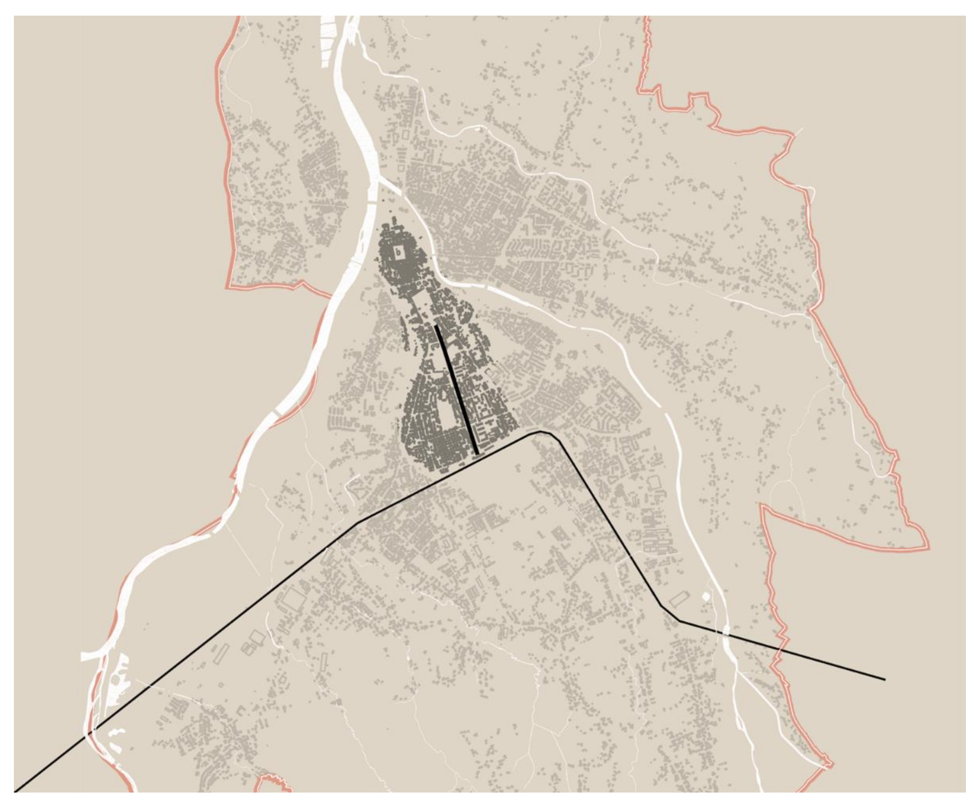
As a result of the space syntax analyses conducted, those elements forming the main structure of the city of Nowy Sacz were identified. One of the factors determining the position in the system would be the scale of connections with other corridors and the ability to aggregate the urban activities of different corridors, and the range of their transfer to different regions of the city. It was observed that the examined structure generated a peculiar internal hierarchical system based on the dominance of one main element. Based on the results of the space syntax study, there is a clear and strong corridor of urbanity—running north–south as a radial road. The course of this corridor is repeated practically in each iteration of the next development phase, starting from the Middle Ages (
Figure 16).
The study results indicated the dominant position of the corridor based on the streets’ core referred to as the “Medieval Centre–Railway Station Strip” or “North–South Strip”. The projected range of development of this part of the structure may be closed from the medieval main market square on the northern side and by the railway station complex on the southern side (see
Figure 5). Syntactic factors determining the prevalence of this corridor:
Accessibility of areas belonging to the corridor;
Number and importance of connections to other minor corridors;
High investment potential located in the corridor’s girdle;
Integration with the network of significant public open spaces of the city center.
Therefore, from the point of view of the structure’s configuration, this corridor should be strengthened. It seems valuable to densify/crystallize the structure of buildings and functions along the corridor. Additionally, to increase accessibility and prevent urban sprawl, the system should be enclosed with concentric ring roads.
From city documents and strategies, the three primary possible scenarios of Nowy Sącz development were estimated.
The optimistic scenario assumes optimal development conditions will occur. The city will use all development opportunities to achieve success in all priority areas. As a result of realizing the optimistic scenario, Nowy Sącz has a chance to be a coherent and spatially structured functional area, a solid subregional center. It can be a city accessible by communication, freed from heavy transit traffic, and offering high-quality public services and clean environmental resources; and through the implementation of the goals as mentioned above—a city stopping the depopulation process [
2,
4].
The moderate development scenario is a kind of compromise between the optimistic and pessimistic scenarios, with preservation of the current position of Nowy Sącz: development of modern transport infrastructure, especially roads; slowing down and stopping the process of suburbanization (urban sprawl); and the implementation of infrastructure projects [
2].
The pessimistic scenario assumes the occurrence of the worst possible conditions of development and the risk of failure to take advantage of the opportunities, as well as the materialization of threats: increase in energy prices; shrinking resources of the local labor market; depopulation and aging of the society; segregation of urban space (ghettoization and gentrification); halt in the city development—stagnation with a threat of economic regression; the “shrinking” city syndrome—lack of new investments [
2,
4].
The designated revitalization areas constitute the very core of the city center. The processes taking place there and the resulting transformations of the functional and spatial structure caused by the market rules should lead to an automatic improvement in the residents’ quality of life and the public space. The revitalization should focus on degraded areas in the girdles of corridors characterized by a high structure-creating, syntactic potential—which serves as vital links. Links to elements of the urban structure, especially local urbanity nodes, should be considered in the program’s update for the rehabilitation of residential areas [
33].


