Review

Challenges and Prospects of Advancing Groundwater Research in Ethiopian Aquifers: A Review

1
Civil and Environmental Engineering Department, University of Science and Technology (UST), Daejeon 34113, Korea
2
Department of Water Resources and River Research, Korea Institute of Civil Engineering and Building Technology, Goyang 10223, Korea
*
Author to whom correspondence should be addressed.
Sustainability 2021, 13(20), 11500; https://0-doi-org.brum.beds.ac.uk/10.3390/su132011500
Submission received: 24 August 2021 / Revised: 13 October 2021 / Accepted: 13 October 2021 / Published: 18 October 2021
(This article belongs to the Special Issue Sustainable Groundwater Resources Management)

Abstract

:
Groundwater is a strategic resource in all climatic regions of Ethiopia, contributing about 80% of the domestic supply of urban and rural populations. However, little research has been available compared with extensive geographical coverage and increasing population growth rates. Hence, the present study aimed to review published groundwater research of Ethiopian aquifers to realize potential research challenges and suggest future research directions. We focused on groundwater potential, recharge process, and qualities. The total potential groundwater of the country ranges from 2.5 to 47 billion cubic meters. The study depicted that the mean annual recharge estimate varies from 24.9 mm to 457 mm at catchments scales. However, the overall country was about 39.1 mm. The study found a need for a detailed investigation of different factors susceptible to groundwater pollution, as some of the evaluations indicated exceeding acceptable standards. This study observed that the main challenge was the lack of data and convergence research trends. Henceforth, future research in different climate regions should focus on multifaceted technical and stakeholder settings. This study gives the insight to integrate palatable research findings with the national policy and decision-making process to enhance the sustainability of groundwater resources significantly.

1. Introduction

Groundwater management is a global challenge due to rapid population growth, urbanization, climate change, and anthropogenic activities [1,2,3]. About 30.1% of global freshwater belongs to groundwater resources [4,5]. A global estimate indicated that nearly half of the global current potable water supplies are groundwater [6,7]. Groundwater is the most substantial clean and significant resource in maintaining human and ecosystems adaptation [8]. However, a lack of effective management strategies in increasing demand and erratic recharge affects groundwater [9,10]. Groundwater abstraction from total global withdrawals takes about 33% and provides water for agronomic (42%), domestic (36%), and manufacturing (27%) requirements [6,11,12]. As a reliable source of water supply, groundwater is dependable and occupies all geologic layers [13,14,15,16].
Groundwater development activities face numerous issues from planning to implementation stages. Groundwater is a relatively clean, reliable, and cost-effective resource in parts of Africa that are almost wholly dependent on groundwater [17,18]. Africa’s groundwater utilization has been projected to increase in the next few decades due to the rapid increase in population and abstraction for different activities [19]. Since aquifers are complex systems confined underground, there would be a severe problem due to the lack of proper groundwater management in sub-Saharan Africa, including Ethiopia [15,20].
In Ethiopia, the integrated development of surface water-groundwater interactions is still scarce due to knowledge gaps of the subject [21]. The surface water-groundwater interactions impact water quantity and quality in aquifers and surface water bodies [22]. Surface water and groundwater resources conjunctively met water competition among agricultural, municipal, and industrial zones [23]. Over-extraction causes a decline in the water table, affecting streamflow connected to the aquifer and damaging water resource sustainability and the ecosystem [24,25]. Hence, understanding surface water-groundwater flow dynamics is crucial to address the research gaps and sustainable water resources management scenarios in different climatic regions of the country.
Ethiopia is heavily dependent on groundwater for drinking, livestock production, and industries. More than 80% of the water supply comes from aquifers [26,27]. Groundwater is a renewable crucial water supply for the great majority of the population in different regions [28]. However, the scarcity of in situ soil and groundwater data used in hydrogeological applications limits the ability to evaluate water resources [28,29]. Nevertheless, groundwater is a fundamental element of national development. However, it is not well studied, and valuable information about recharge rates is unavailable due to data paucity [30,31,32,33]. Thus, it causes failure to different development projects, resulting in financial expense. Furthermore, groundwater’s essential role and contribution to water infrastructure development have not historically been anticipated in Ethiopia. Therefore, studying the spatiotemporal extents of groundwater utilization with a wide range of technical and institutional strategies is significant.
Though Ethiopia has much spatiotemporal distribution and rate of groundwater potential [34,35], there is no agreement on quantitative representation. Various stakeholders [36,37,38] argued that hydrological features are critical for predicting spatial and temporal variability. Weather variability significantly affects hydrological cycles and water policy provision in the Horn of Africa, including Ethiopia [39]. However, all-controlling parameters have hardly ever been studied in an integrated approach, as conventional strategies tend to be time-consuming and costly [40].
Anthropogenic actions have an intense influence on the hydrologic cycle of water flows, storage, soil, and atmosphere [41,42]. The spatiotemporal variability of water storage in Ethiopia faces a range of water management challenges caused by anthropogenic pressures and climate variability [43]. These activities, combined with the natural process such as vegetation, climate, and geology, have influenced water quality and quantity [44]. In addition, vegetation cover and land-use patterns can profoundly affect the aquifer recharge process [45].
Geographic information system (GIS) has been used for decades to identify and assess groundwater pollution in different parts of the world. The vulnerability of groundwater to contaminants was the product of a finite combination of different factors, beginning with hydrogeological settings and human activities whose attachment is formed in a regular pattern [46,47,48]. Assessment of exposure to groundwater pollution based on GIS has been practiced in some areas of Ethiopia [32,49]. Studies showed that groundwater has a high concentration of nitrates and microbes [50]. Groundwater vulnerability studies using DRASTIC (depth to groundwater (D), net recharge (R), aquifer media (A), soil media (S), topography (T), the impact of the vadose zone (I), and hydraulic conductivity (C)) model estimate the relative chances of groundwater contamination with specific constituents [51]. The DRASTIC model identified the potential risk of aquifers for temporary protection over a large area with minimal cost and time changes essentially on aquifer storage [52]. These changes have impacted the water balance of the watershed by changing groundwater levels due to anthropogenic activities.
Due to rapid population growth, expansion and effective use of shallow groundwater supply for agriculture and domestic services are mandatory [53,54,55]. Despite the high groundwater potential and opportunity to overcome drought in Ethiopia, no significant attention has been given to using groundwater for agriculture [56]. Precipitation is generally insufficient to sustain the agriculture needed to alleviate food insecurity. A few places have demonstrated comparative advantages of groundwater irrigation over rain-fed agriculture and surface water irrigation [29,57].
Although there is little research on potential groundwater assessment in Ethiopia, some has been done in recent studies [35,38,57,58,59,60]. The variation of groundwater in the country varies, as observed in different studies, for example, from 2.5 to 6.5 [35,57], 30 [60], 36 [15], 40 [38], and 47 [61] in billion cubic meters (BCM), which can be either an underestimation or overestimation. This vagueness in figures can hinder the pursuit from exploiting its water resources to the limit. This extremely high discrepancy in the potential figures is a challenge for experts and decision-makers. Thus, challenges faced by the water sector lock fund and other supporting agencies to the economic development of Ethiopia’s water resources. Detailed studies and surveys are needed to estimate groundwater resources with better accuracy and reliability.
Therefore, the main objective of the present study is to review published groundwater research in Ethiopian aquifers to identify the challenge and prospects of advancing groundwater research. Thus, the study can help identify the possible research gaps that need detailed investigations to enhance the sustainable utilization of groundwater resources of the country.

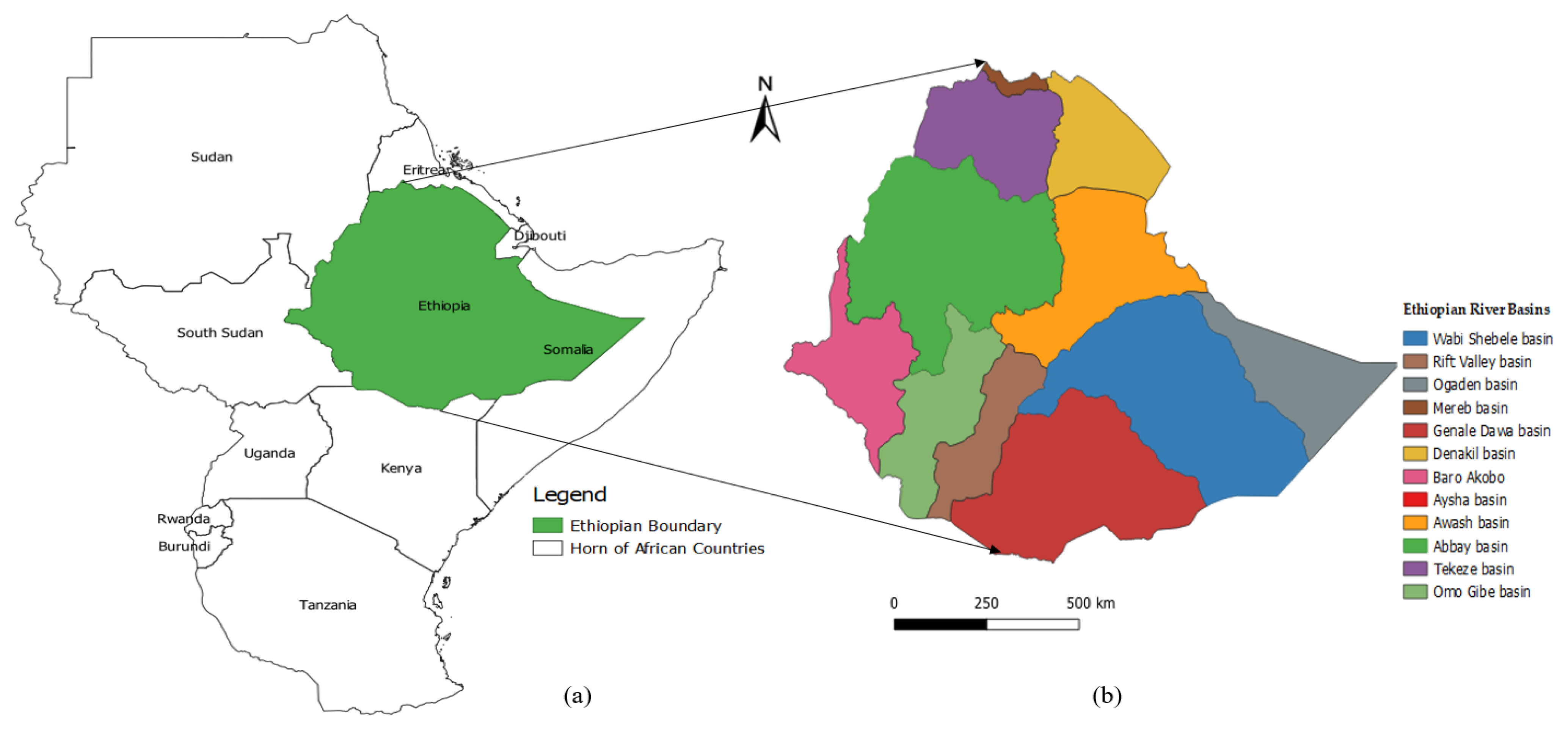
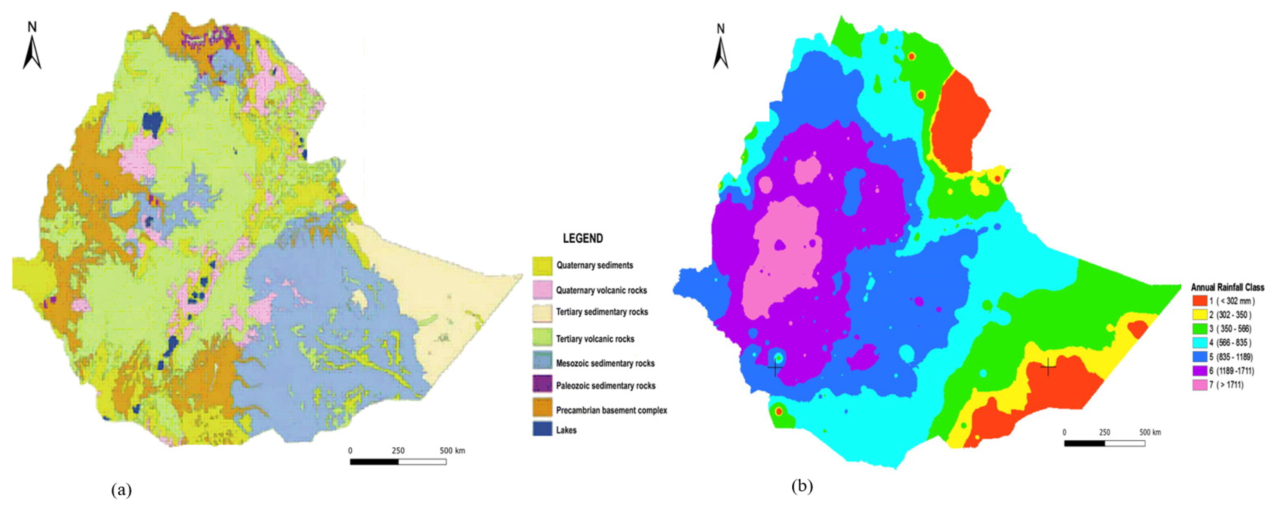
2. Background of the Study Area

Ethiopia is one of the largest African countries (Figure 1a), surrounded by Eritrea, Sudan, Kenya, Somalia, Djibouti, and South Sudan. The country is scanty in rainfall-dependent agricultural practice with great geological complexity and geographic diversity. Most rivers flow through the country border, and groundwater resources deplete due to poor land use and watershed management practice. The country has twelve River basins: Abay, Awash, Baro-Akobo, Genale-Dawa, Mereb, Omo-Gibe, Tekeze, Wabishebbele, and Mereb have water flows. Aysha, Denakil, and Ogaden dry basins with no flow out of the drainage system [57,60]. The spatial distribution of main river basins is shown in Figure 1b.
The country has varied climatic conditions ranging from arid to humid, a complicated topography, and abundant water resources. The highlands across each corner give way to broad semi-arid lowland regions to the east, west, and south [35]. The average annual rainfall ranges from 141 mm along the country’s arid eastern and northeastern borders to 2275 mm in the southwestern highlands, as indicated in Figure 2b [62]. The spatiotemporal distribution of water supply is characterized by multi-weather systems rainfall. Most river courses become fully flooded in their surroundings during the preceding rainy months (June–September). Unlike the northeast and east-flowing rivers, west-flowing rivers receive much rainfall, which is usually low [60,63,64].
In Ethiopia, groundwater abstraction covers about 90% of water for domestic supply and 95% industrial activities [15]. Groundwater tapping systems are springs, widespread in the escarpment and the highlands, which supply the great majority of the rural community. Hand-dug wells and springs often do not withstand prolonged droughts [34]. Therefore, developing artificial springs and wells to acquire water security for drought season is needed [54,65].
The recent increase in groundwater development threatens sustainability, particularly in urban areas that rely on groundwater. Aquifer depletion has increasingly affected water service delivery in large urban areas of Ethiopia. According to Birhanu et al. [66], the continuous groundwater abstractions without considering surface water sources decline groundwater levels in hot spot areas (Addis Ababa, Mekelle, Axum, Harar, and Gondar towns). Over-exploitation damages aquifers if sustainable management strategies are not hosted via interactive utilization of surface and groundwater to enhance balancing supply and demand [67]. The increasing demand from a growing population and high food insecurity in many parts of the country have started to overexploit groundwater, resulting in declining water tables [19].
Groundwater resource in Ethiopia is under a complex geological construction and the diversity of the topography, climate, and soil. Ethiopia’s Rift volcanic terrain is complex by the destruction of rock units caused by faults and variability of volcanic structures. Transverse fault zones cross the Rift; up to 50% of recharge of aquifers comes from the plateau as groundwater inflow [68]. The Ethiopian aquifers were clustered as volcanic rock, sedimentary, metamorphic, alluvial lacustrine sediment, and from low to moderate range of productivity [15,19]. Aquifers are dispersed into Precambrian basement (18%), Paleozoic and Mesozoic sedimentary rocks (25%), Tertiary sedimentary and volcanic rocks (40%), and Quaternary sedimentary and volcanic rocks (17%) [34,62].
The geological formations and recharge rates influence the occurrence and distribution of groundwater. The geology, physiography, and climate change conditions are diverse, and groundwater distribution is highly variable, impacting aquifers’ productivity [34]. The productivity of aquifers’ increases with depth [14]. The groundwater flow system and mechanism of recharge of different aquifers result indicate a quite complex flow pattern and hydraulic features of the different volcanic aquifers occurred on the inter-basin groundwater transfer conditions. The groundwater from the deep investigative wells was relatively depleted [69].
The temporal and spatial variation of groundwater occurrence is very high due to extreme structural positions and lithological variations. Recharge is highest in the northeastern and southwestern plateau, where annual rainfall is high, as shown in (Figure 2b) [57]. Rapid infiltration occurs in areas covered by fractured volcanic and, to a lesser extent, in sedimentary rocks and thick permeable soils [19]. The volcanic terrain and associated quaternary deposits are complex aquifer systems. The geomorphological architecture of the plateau, escarpments, and Rift valley control groundwater occurrence and distribution [14,56,70,71].
The lateral continuity of aquifers and groundwater flow is disturbed by faults, which divert groundwater to the rift axis. Groundwater flows in the rift and escarpments are controlled mainly through faults with high aquifer hydraulic characteristics and recharge rates [14]. Valley floor Quaternary alluvial sediments and essential Tertiary fractured volcanic aquifers characterize a considerable amount of exploitable hydrostratigraphic units [56]. The groundwater flow converges to the seismically active volcano-tectonic depressions according to geological settings [70]. The study disclosed that recharge supply comprises distinct zones of rift volcanic terrain bordered with highlands and transitional escarpments.
The geological distribution was categorized as sedimentary and Mesozoic sandstone to the southern, karstic rocks to the eastern and southeastern (Figure 2a). Quaternary volcanic rocks, unconsolidated sediments, fractured intrusive rocks, old Precambrian rocks, and metamorphic rocks belong to the western part of aquifer characteristics [62,69,72]. Enormous practical implications for ample groundwater storage at a more considerable depth solve the community’s water supply problems in various parts of the country, which is vital for sustaining aquifers’ recharge sources and hydraulic conductivity.

3. Study Type and Challenges

3.1. Groundwater Potential

Assessing groundwater potential is essential in all climatic regions to its limited vulnerability, low development cost, and drought reliability to sustain water-food security issues [73]. However, estimating groundwater potential is still having uncertainties due to the hydrogeological nature of river basins. The scarcity of water is becoming increasingly prominent. For example, in the millennium declaration, the Ethiopian government adopted sustainable development goals [74]. Maintaining water quality and ensuring safe drinking water is essential to achieving the goal. It strives to achieve this goal by integrating its growth and transformation plan. However, the water management sector could not stay productive yet due to the temporal and spatial variation, the reduction in intensity, and shift in rainfall season [75]. The potential of groundwater development and climate change adaptation is still quite under-investigated [26]. The potential is not always accurately described, as groundwater recharge for the region lacks evaluating tools and proper knowledge on how the groundwater budget behaves [76,77].
Remote sensing (RS) and GIS techniques were applied to identify potential groundwater zones of Ethiopian aquifers [40,58,78,79,80,81,82,83,84,85,86,87], as illustrated in Table 1. The efficacy of RS in hydrogeological research can offer vital spatial and temporal data sets critical for realistic analysis, prediction, and validation of water resource models. In addition, GIS-based overlay analysis combined with pairwise comparison was a promising approach for predicting groundwater recharge zones in different catchments [83,84,87].
In the potential groundwater zones determination studies, many features have been used based on geologic, hydrologic, hydrogeological, meteorological, and terrain capabilities as selection criteria [80,81,83]. Accordingly, geomorphology, lithology, slope, rainfall, land use, land cover, soil, lineament density, elevation, topographic wetness index, topographic position index, curvatures, stream power index, hydraulic conductivity, distance from the fault, roughness, and drainage density were the main factors affecting groundwater potential. These parameters were classified and ranked depending on the suitability of groundwater potentiality. However, some of the studies were conducted using a limited number of influencing factors that might lead to unsatisfactory decision-making processes.
Nevertheless, the most dominant groundwater potential affecting factors have not been explained other than overlaying random parameters. Therefore, many influencing factors have to be considered and tested for the reliability of a tremendous decision-making process and groundwater yields. The area of coverage (km2), study catchments, number of parameters applied (N), and groundwater potential zone (GWPZ) mapping of peer-reviewed studies in Ethiopia at different catchments are shown in Table 1.

3.2. Groundwater Recharge

Groundwater is a critical source of agriculture and drinking water supply [88]. Therefore, estimating the recharge rate is significant to assure efficient and sustainable management [61,89]. Furthermore, understanding the rates and locations of recharge is necessary for evaluating the sustainable yields of the groundwater systems [2,90,91,92]. Recharge estimation could be achieved by assessing development impacts, predicting climate change, and increasing abstraction rates [9,93,94,95]. However, the recharging mechanism is an essential indicator of hydrologic conditions affecting aquifer production [15,27]. Sources of groundwater recharge in Ethiopia are flood recharge, rainfall recharge, and mountain block recharge [27]. Almost 60% of aquifers receive indirect recharge from storms, mountain runoff, and rapid recharge from heavy rainfall events. Diffuse recharge is restricted to plateau areas, covering approximately 30% of the country and 10% of groundwater recharge from losing streams and flash floods [15]. Ethiopian highlands have high infiltration rates [50]. Extensive percolation through the vadose zone gives reliable recharge for the soil moisture estimation [62,96]. Thus, infiltration takes place from vadose to saturated zone, increasing water table and streamflow.
Many studies in groundwater recharge estimation have agreed on the necessity of quantitative decisions on exploitation activity through recharge studies to safeguard natural resources [94,97]. However, computing recharge is a complicated hydrological parameter [91,98] for many developing countries like Ethiopia, known for abundant water resources [15,88,99]. With the rapidly increasing population growth and escalating water demand, groundwater abstraction appeared to be beyond its recharge rate challenged groundwater development [96]. Though there is little research on groundwater recharge estimation in Ethiopia, some analysis has been done in recent studies [9,10,64,94,97].
In Ethiopia, limited recharge estimation and groundwater flow modeling studies were conducted with limited data availability. Description of peer-reviewed published research articles indicated in Table 2 emphasized estimating groundwater flow dynamics and recharge of aquifers applying the following applications. The Newton-Raphson formulation for modular finite-difference groundwater flow (MODFLOW) was applied to evaluate groundwater flow dynamics [9,26,33,72,95,100]. The model predictions reveal that aquifers increase withdrawal and decrease recharge. Increased pumping and decreased recharge results indicated that there is a decline in lakes and rivers levels [95,100]. Thus, reservoirs and rivers play a crucial role in recharging aquifer systems. Increasing human demand for groundwater and variability in recharge affects groundwater contribution to surface water and ultimately are a supply of concern for future groundwater management.
The Soil and Water Assessment Tool (SWAT) coupled with MODFLOW (SWAT-MODFLOW) were also applied to determine the recharge process through surface water-groundwater interactions [10,21]. The studies disclosed that robust interactions between the stream and groundwater advance flow dynamics of hydrogeological conditions. Surface water-groundwater exchange rates are highly variable; the annual altercation is from hydrogeological system to streams indicating that streams are gaining. Throughout the wet seasons, the flow is preponderantly from the stream system to the aquifer. Moreover, recharge takes place from the aquifer to the stream from July to October. In addition, the groundwater head converges towards the mainstream, revealing that a high rate of pumping declines groundwater level and substantial river base flow.
Soil water balance (SWB) [94,97,99], chloride mass balance (CMB) [94,97], water table fluctuation model (WTF) [94], and water balance model (WetSpass) [64,88,93,96] were applied for appraisal of groundwater recharge and other water balance components. Studies support that evapotranspiration is happening from the groundwater to the unsaturated soil zone before the percolation of groundwater [94]. Studies in Ethiopian aquifers revealed that recharge is high during the summer season and minimum in winter. The average annual groundwater recharge is 4.2% of annual precipitation occurs during the wet season as in [64]. During the spring season, percolation is minimal due to unrestricted movement of water in the soil zone with a low antecedent moisture content of the soil [64,94,97,99].
According to studies, the mean annual rate of recharge varies at catchment scales from 24.9 mm [96] to 457 mm [97] as compared with the overall country’s estimate made between 39 mm [15] and 39.1 mm [61]. This non-uniformity is mainly due to multiple influencing factors for groundwater recharge and potential [34]. However, the lack of up-to-date spatial and temporal information is becoming an increasingly prominent challenge to indicate sustainability considerations.
The absence of recent information on the spatiotemporal distribution of groundwater resources is Ethiopia’s critical concern and issue [58,82]. GIS and RS applications can be applied to tackle data scarcity of the area as suggested by [12], after reviewing various studies conducted on groundwater recharge estimation in Africa’s semi-arid and humid regions. The source and spatial distribution of groundwater recharge in Ethiopia are not well described yet. Some peer-reviewed published groundwater recharge and flow application studies in Ethiopian aquifers with catchment name, the total area of coverage (km2), mean annual recharge of the catchment (mm), and applied techniques are presented in Table 2.

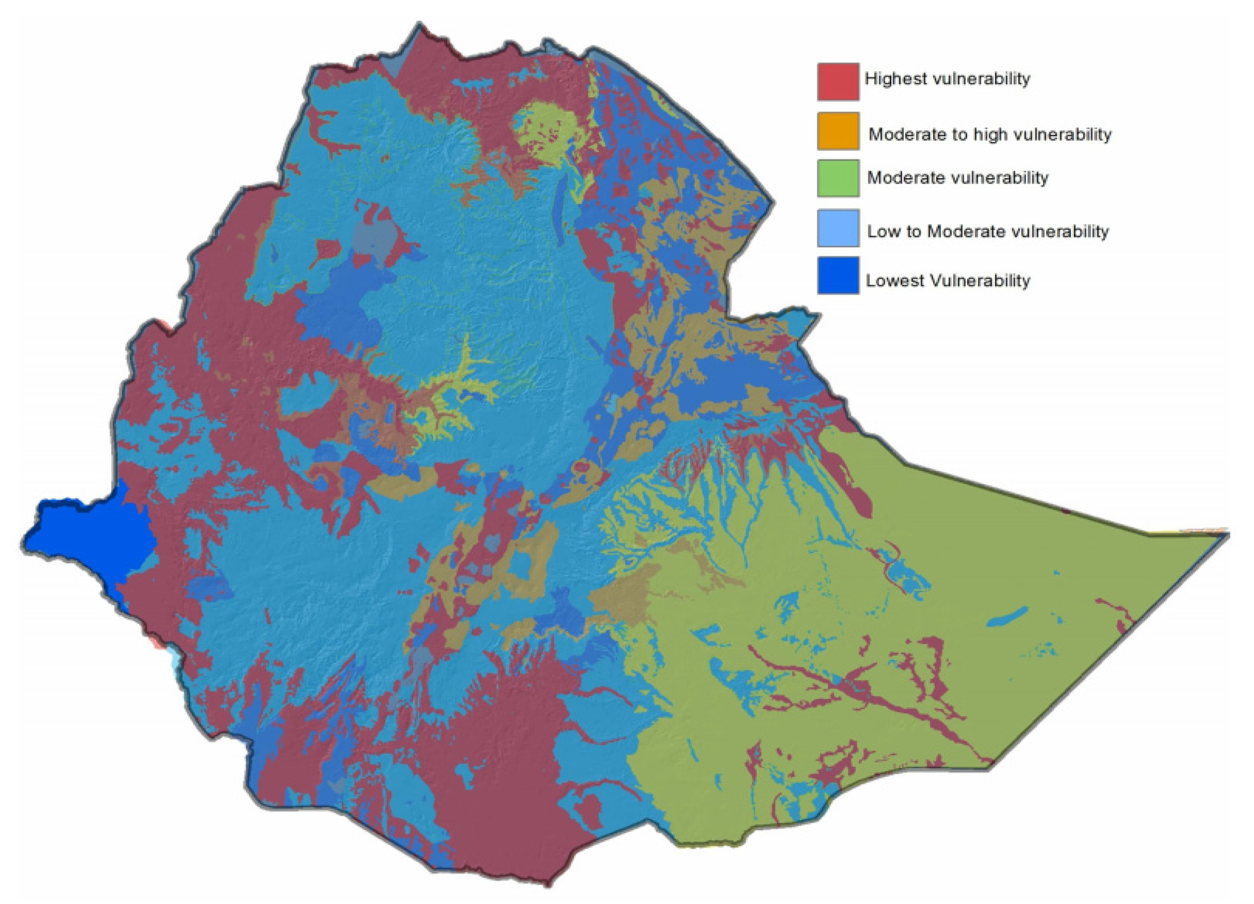
3.3. Groundwater Quality

Groundwater development has combined effects on human development: food security, drinking water, sanitation, and climate change mitigations [101,102,103,104]. However, groundwater quality has declined due to industrial effluents and domestic wastes and the widespread use of fertilizers for agricultural purposes in shallow aquifers [48,84,102]. Therefore, overexploitation and utilization must be well managed, especially in areas threatened by contamination.
Human activities have disrupted hydrogeological and chemical conditions [69,70,71,105]. The most severe issue is a lack of knowledge about pesticides and other chemical pollutants such as personal care items in groundwater and agricultural areas irrigated by highly polluted waters [106,107,108,109]. Therefore, determining the nature of chemical pollutants in groundwater and their vulnerability and their persistence is paramount. However, such studies were conducted in limited parts of the country, as described in Table 3, though many areas need in-depth investigations. For example, the distribution of existing studies are found in Lake Tana basin [76] and Megech watershed [48] (Northwest Ethiopia); Dire Dawa (Eastern Ethiopia) [51]; Elalla-Aynalem well fields [110] (Northern Ethiopia); Lower Ketar [111], Adama Town [101], and Modjo River catchment [112] (Central Ethiopia).
The vulnerability of groundwater to contaminants resulted from a finite combination of hydrogeological setting and human activities [46,47,48]. GIS has been used to assess groundwater pollution in different parts of the world for decades. Assessment of exposure to groundwater pollution based on GIS has been practiced in some areas of Ethiopia [48,51,76,110]. Studies showed that groundwater has a high concentration of nitrates and microbes [13,43,49,50]. Groundwater vulnerability studies using the GIS-based DRASTIC model to estimate groundwater pollution were also practiced [51]. Sustainable groundwater vulnerability management can be achieved when potential pollutants, users, and other stakeholders are actively involved, including planning and implementing effective regulations [52]. Therefore, the evaluation of vulnerability and groundwater quality is needed, which helps to check groundwater sustainability. Although there is little research on groundwater quality in Ethiopia, some analysis has been done in recent studies using GIS-based DRASTIC and water quality index (WQI) methods, as depicted in Table 3.
The DRASTIC model identified the potential risk of aquifers for temporary protection over ample aquifer storage effectively [48,51,76,110]. The vulnerability assessment identified and delineated aquifer vulnerability spatial extent to pollution of the area. Vulnerability evaluation has been analyzed with depth to the water table, net recharge, aquifer media, soil media, topography, vadose zone, hydraulic conductivity, and land use and land cover as essential parameters [48,51,76,110]. The study results indicated that catchment characteristics impacted the vulnerability of aquifers investigated. The findings suggested that groundwater pollution risk needs immediate implementation of acceptable practices. Thus, the increasing risks of groundwater pollution could also be related to farming and urban expansion. These areas provide water to urban and farming intensifications, and chemicals will deteriorate groundwater quality.
Most observation wells with high nitrate contamination fall in agricultural and urban areas and transport levels exceeding criteria set by World Health Organization (WHO) [48,51]. Aquifers extremely at risk of pollution are found in urban areas such as Gondar, Bahir Dar, and Dire Dawa. Accordingly, the instability of aquifers varies from low to high. It should be applied with similar or different agro-climatic and management conditions to forward practical and updated information for policymakers [51]. Therefore, the DRASTIC method was recognized to be an auspicious method for rectifying vulnerable groundwater sites. Evaluating the extent of groundwater vulnerability is considerably needed in different parts of the country, especially agricultural and urban landscapes.
WQI evaluates the suitability of water for domestic and agricultural purposes. Anthropogenic activities of urban and fertilizers govern the groundwater chemistry. [101,112]. Almost all groundwater studies conducted in Ethiopia indicated limited to fixing single model analysis. Thus, public policies should be implemented to reduce the potential points and sources of contamination affecting the catchments in wastewater effluents from industry, increasing pollution and toxicity in river waters and plants [44].
The erratic variability in rainfall distribution (Figure 3) and shortage of perennial streams have augmented the dependability of groundwater for irrigation [32,54,55,56,57]. However, people have been using groundwater from wells without understanding the consequence of over-pumping. Regulating and maintaining groundwater storage in dynamic equilibrium is crucial without disturbing the natural conditions. Ethiopia has been limited to combat droughts to improve irrigation practices for supporting an agricultural-dependent economy [113].
The main challenge of groundwater and drought resilience was that most hand pumps, springs, hand-dug wells, and boreholes are not functional due to deterioration, improper positioning, and maintenance [65]. Hence, comprehensive and integrative approaches are needed to evaluate anthropogenic activities with the alarmingly increasing global warming and climate change. The existing national level groundwater vulnerability rates spatial distribution as indicated in Figure 3. However, as the multiple input parameters of the models vary with time and other human and natural activities, the investigation should be updated at the national level and catchment-specific conditions for the sustainable management and decision-making process.

4. Summary and Future Directions

In this study, we assessed peer-reviewed published groundwater research conducted in Ethiopian aquifers. The assessment covers groundwater potential, groundwater recharge process, and groundwater qualities. As a result, the groundwater potential of the nation shows from 2.5 to 47 billion cubic meters, and there is no consensus on the numerical value of groundwater potential in Ethiopia. Groundwater potential zonation was conducted with a limited number of influencing factors. A dominant influencing factor has not been identified yet. However, influencing parameters have a direct impact on the decision of planning resource allocation. The recharge estimation assessment indicated that the mean annual groundwater recharge varies from 24.9 mm to 457 mm at catchment scales.
Susceptibility of groundwater to pollutants was a product of a finite mixture of different factors that need a detailed investigation, and some of the assessments indicate exceeding acceptable levels of WHO. Therefore, producing and disseminating practical information about groundwater trends to policymakers and development practitioners is critical. Furthermore, integrating groundwater research into national policies provides an adequate and influential contribution to economic development plans that need an integrated research output. Due to hydrogeological variability, multi- and inter-disciplinary research approaches are vital to address the intricate relations in the hydrologic cycle and interactions with the broader societal, physical, ecological, and environmental policy issues. However, the lack of data and convergence research approaches found a fundamental challenging problem of the assessment. Groundwater abstraction for domestic water demand and the cumulative effect of abstraction for industrial uses and livestock impacted the aquifer system. Hence, it would be better to address the following gaps and insights to have comprehensive groundwater management.
  • The continuous dynamics of land use and climate change have multiple impacts on groundwater recharge in different regions. Hence, the drivers of combined effects of land use and climate change on aquifer recharge and quality require detailed investigation.
  • Sustainability indicators are indispensable to increase policymakers’ awareness of the safe yield of groundwater for sustainable development strategies. Therefore, groundwater sustainability should be evaluated with leading sustainability indicators and integrated with the national policy.
  • Coupled hydrologic models can quantify and qualify water availability under current and future scenarios and enhance urban and rural water security. Hence, the application of coupled hydrological modeling is required to properly quantify the combined effects of groundwater abstractions with surface water utilization.
  • Groundwater is the most significant source of domestic supplies for urban and rural populations. The scarcity of reliable data on groundwater is the main challenge of many developing countries such as Ethiopia. Hence, as most Ethiopian aquifers lack relevant data, researchers should use GIS and RS technology to determine dependable recharge that resembles the actual values. In addition, the use of current advanced knowledge of artificial intelligence techniques is required to increase water resources research predictive capability and sustainable management insights.

Author Contributions

Conceptualization, T.D.M. and I.-M.C.; writing—original draft preparation, T.D.M.; writing—review and editing, B.A.Y. and I.-M.C.; resources and data curation, J.L., H.H.W. and M.-G.K.; visualization, M.-G.K. and I.-H.K.; supervision, I.-M.C. and S.W.C.; funding acquisition, I.-M.C. and S.W.C. All authors have read and agreed to the published version of the manuscript.

Funding

This research was supported by a grant from the Development Program of Minimizing of Climate Change Impact Technology funded through the National Research Foundation of Korea (NRF) of the Korean government (Ministry of Science and ICT, Grant No. NRF-2020M3H5A1080735) and the Korea Ministry of Environment (MOE) as a Demand Responsive Water Supply Service Program (146515).

Institutional Review Board Statement

Not applicable.

Informed Consent Statement

Not applicable.

Data Availability Statement

Data available in a publicly accessible repository.

Conflicts of Interest

The authors declare no conflict of interest.

References

  1. Taylor, R.G.; Scanlon, B.; Döll, P.; Rodell, M.; van Beek, R.; Wada, Y.; Longuevergne, L.; Leblanc, M.; Famiglietti, J.S.; Edmunds, M.; et al. Ground water and climate change. Nat. Clim. Chang. 2013, 3, 322–329. [Google Scholar] [CrossRef] [Green Version]
  2. Sophocleous, M. Global and Regional Water Availability and Demand: Prospects for the Future. Nat. Resour. Res. 2004, 13, 61–75. [Google Scholar] [CrossRef]
  3. Giordano, M. Global Groundwater? Issues and Solutions. Annu. Rev. Environ. Resour. 2009, 34, 153–178. [Google Scholar] [CrossRef]
  4. Lal, R. World Water Resources and Achieving Water Security. Agron. J. 2015, 107, 1526–1532. [Google Scholar] [CrossRef] [Green Version]
  5. Trenberth, K.E.; Smith, L.; Qian, T.; Dai, A.; Fasullo, J. Estimates of the Global Water Budget and Its Annual Cycle Using Observational and Model Data. J. Hydrometeorol. 2007, 8, 758–769. [Google Scholar] [CrossRef]
  6. Döll, P.; Hoffmann-Dobrev, H.; Portmann, F.T.; Siebert, S.; Eicker, A.; Rodell, M.; Strassberg, G.; Scanlon, B.R. Impact of water withdrawals from groundwater and surface water on continental water storage variations. J. Geodyn. 2012, 59–60, 143–156. [Google Scholar] [CrossRef]
  7. Hiscock, K.M. Groundwater in the 21st Century—Meeting the Challenges. In Sustaining Groundwater Resources; Springer: Dordrecht, The Netherlands, 2011; pp. 207–225. [Google Scholar]
  8. Bovolo, C.I.; Parkin, G.; Sophocleous, M. Groundwater resources, climate and vulnerability. Environ. Res. Lett. 2009, 4, 035001. [Google Scholar] [CrossRef]
  9. Gebere, A.; Kawo, N.S.; Karuppannan, S.; Hordofa, A.T.; Paron, P. Numerical modeling of groundwater flow system in the Modjo River catchment, Central Ethiopia. Model. Earth Syst. Environ. 2021, 7, 2501–2515. [Google Scholar] [CrossRef]
  10. Tolera, M.B.; Chung, I.-M. Integrated Hydrological Analysis of Little Akaki Watershed Using SWAT-MODFLOW, Ethiopia. Appl. Sci. 2021, 11, 6011. [Google Scholar] [CrossRef]
  11. Siebert, S.; Burke, J.; Faures, J.M.; Frenken, K.; Hoogeveen, J.; Döll, P.; Portmann, F.T. Groundwater use for irrigation—A global inventory. Hydrol. Earth Syst. Sci. 2010, 14, 1863–1880. [Google Scholar] [CrossRef] [Green Version]
  12. Chung, I.-M.; Sophocleous, M.A.; Mitiku, D.B.; Kim, N.W. Estimating groundwater recharge in the humid and semi-arid African regions: Review. Geosci. J. 2016, 20, 731–744. [Google Scholar] [CrossRef]
  13. Legesse, D.; Ayenew, T. Effect of improper water and land resource utilization on the central Main Ethiopian Rift lakes. Quat. Int. 2006, 148, 8–18. [Google Scholar] [CrossRef]
  14. Ayenew, T.; Demlie, M.; Wohnlich, S. Hydrogeological framework and occurrence of groundwater in the Ethiopian aquifers. J. Afr. Earth Sci. 2008, 52, 97–113. [Google Scholar] [CrossRef]
  15. Kebede, S. Groundwater in Ethiopia; Springer Berlin Heidelberg: Berlin/Heidelberg, Germeny, 2013; ISBN 978-3-642-30390-6. [Google Scholar]
  16. Alemayehu, T.; Kebede, S.; Liu, L.; Kebede, T. Basin hydrogeological characterization using remote sensing, hydrogeochemical and isotope methods (the case of Baro-Akobo, Eastern Nile, Ethiopia). Environ. Earth Sci. 2017, 76, 466. [Google Scholar] [CrossRef]
  17. Foster, S.; Chilton, J.; Nijsten, G.J.; Richts, A. Groundwater-a global focus on the “local resource”. Curr. Opin. Environ. Sustain. 2013, 5, 685–695. [Google Scholar] [CrossRef]
  18. Braune, E.; Xu, Y. The Role of Ground Water in Sub-Saharan Africa. Ground Water 2010, 48, 229–238. [Google Scholar] [CrossRef] [PubMed]
  19. Pavelic, P. Groundwater Availability and Use in Sub-Saharan Africa: A Review of 15 Countries; International Water Management Institute (IWMI): Colombo, Sri Lanka, 2012; ISBN 9789290907589. [Google Scholar]
  20. Oke, S.A.; Fourie, F. Guidelines to groundwater vulnerability mapping for Sub-Saharan Africa. Groundw. Sustain. Dev. 2017, 5, 168–177. [Google Scholar] [CrossRef]
  21. Tigabu, T.B.; Wagner, P.D.; Hörmann, G.; Fohrer, N. Modeling the spatio-temporal flow dynamics of groundwater-surface water interactions of the Lake Tana Basin, Upper Blue Nile, Ethiopia. Hydrol. Res. 2020, 51, 1537–1559. [Google Scholar] [CrossRef]
  22. Lin, J.; Ma, R.; Hu, Y.; Sun, Z.; Wang, Y.; McCarter, C.P.R. Groundwater sustainability and groundwater/surface-water interaction in arid Dunhuang Basin, northwest China. Hydrogeol. J. 2018, 26, 1559–1572. [Google Scholar] [CrossRef]
  23. Bailey, R.T.; Wible, T.C.; Arabi, M.; Records, R.M.; Ditty, J. Assessing regional-scale spatio-temporal patterns of groundwater-surface water interactions using a coupled SWAT-MODFLOW model. Hydrol. Process. 2016, 30, 4420–4433. [Google Scholar] [CrossRef]
  24. Liu, W.; Park, S.; Bailey, R.T.; Molina-Navarro, E.; Andersen, H.E.; Thodsen, H.; Nielsen, A.; Jeppesen, E.; Jensen, J.S.; Jensen, J.B.; et al. Quantifying the streamflow response to groundwater abstractions for irrigation or drinking water at catchment scale using SWAT and SWAT–MODFLOW. Environ. Sci. Eur. 2020, 32, 113. [Google Scholar] [CrossRef]
  25. Aliyari, F.; Bailey, R.T.; Tasdighi, A.; Dozier, A.; Arabi, M.; Zeiler, K. Coupled SWAT-MODFLOW model for large-scale mixed agro-urban river basins. Environ. Model. Softw. 2019, 115, 200–210. [Google Scholar] [CrossRef]
  26. Khadim, F.K.; Dokou, Z.; Lazin, R.; Moges, S.; Bagtzoglou, A.C.; Anagnostou, E. Groundwater modeling in data scarce aquifers: The case of Gilgel-Abay, Upper Blue Nile, Ethiopia. J. Hydrol. 2020, 590, 125214. [Google Scholar] [CrossRef]
  27. Kebede, S.; Travi, Y.; Alemayehu, T.; Ayenew, T. Groundwater recharge, circulation and geochemical evolution in the source region of the Blue Nile River, Ethiopia. Appl. Geochem. 2005, 20, 1658–1676. [Google Scholar] [CrossRef]
  28. Abiy, A.Z.; Melesse, A.M. Evaluation of watershed scale changes in groundwater and soil moisture storage with the application of GRACE satellite imagery data. Catena 2017, 153, 50–60. [Google Scholar] [CrossRef] [Green Version]
  29. Awulachew, S.B.; McCartney, M.; Steenhuis, T.S.; Ahmed, A.A. A Review of Hydrology, Sediment and Water Resource Use in the Blue Nile Basin; International Water Management Institute: Colombo, Sri Lank, 2008; Volume 131, ISBN 978-92-9090-699-5. [Google Scholar]
  30. Gebreyohannes, T.; De Smedt, F.; Walraevens, K.; Gebresilassie, S.; Hussien, A.; Hagos, M.; Amare, K.; Deckers, J.; Gebrehiwot, K. Application of a spatially distributed water balance model for assessing surface water and groundwater resources in the Geba basin, Tigray, Ethiopia. J. Hydrol. 2013, 499, 110–123. [Google Scholar] [CrossRef]
  31. Dile, Y.T.; Tekleab, S.; Kaba, E.A.; Gebrehiwot, S.G.; Worqlul, A.W.; Bayabil, H.K.; Yimam, Y.T.; Tilahun, S.A.; Daggupati, P.; Karlberg, L.; et al. Advances in water resources research in the Upper Blue Nile basin and the way forward: A review. J. Hydrol. 2018, 560, 407–423. [Google Scholar] [CrossRef]
  32. Akale, A.T.; Dagnew, D.C.; Moges, M.A.; Tilahun, S.A.; Steenhuis, T.S. The Effect of Landscape Interventions on Groundwater Flow and Surface Runoff in a Watershed in the Upper Reaches of the Blue Nile. Water 2019, 11, 2188. [Google Scholar] [CrossRef] [Green Version]
  33. Chebud, Y.A.; Melesse, A.M. Numerical modeling of the groundwater flow system of the Gumera sub-basin in Lake Tana basin, Ethiopia. Hydrol. Process. 2009, 23, 3694–3704. [Google Scholar] [CrossRef]
  34. Tamiru, A. Groundwater Occurrence in Ethiopia; With the support of UNESCO; Addis Ababa University: Addis Ababa, Ethiopia, 2006. [Google Scholar]
  35. Moges, S. AgWater Solutions Project Case Study Agricultural Use of Ground Water in Ethiopia: Assessment of Potential and Analysis of Economics, Policies, Constraints and Opportunities. Gates Open Res. 2012. [Google Scholar] [CrossRef]
  36. Kebede, S.; Charles, K.; Godfrey, S.; MacDonald, A.; Taylor, R.G. Regional-scale interactions between groundwater and surface water under changing aridity: Evidence from the River Awash Basin, Ethiopia. Hydrol. Sci. J. 2021, 66, 450–463. [Google Scholar] [CrossRef]
  37. Tekleab, S.; Uhlenbrook, S.; Mohamed, Y.; Savenije, H.H.G.; Temesgen, M.; Wenninger, J. Water balance modeling of Upper Blue Nile catchments using a top-down approach. Hydrol. Earth Syst. Sci. 2011, 15, 2179–2193. [Google Scholar] [CrossRef] [Green Version]
  38. Mengistu, H.A.; Demlie, M.B.; Abiye, T.A. Review: Groundwater resource potential and status of groundwater resource development in Ethiopia. Hydrogeol. J. 2019, 27, 1051–1065. [Google Scholar] [CrossRef]
  39. Ayele, H.S.; Li, M.-H.; Tung, C.-P.; Liu, T.-M. Assessing Climate Change Impact on Gilgel Abbay and Gumara Watershed Hydrology, the Upper Blue Nile Basin, Ethiopia. Terr. Atmos. Ocean. Sci. 2016, 27, 1005–1018. [Google Scholar] [CrossRef] [Green Version]
  40. Bashe, B.B.; Bezabih Bashe, B.; Bashe, B.B. Groundwater Potential Mapping using Remote Sensing and GIS in Rift Valley Lakes Basin, Weito Sub Basin, Ethiopia. Int. J. Sci. Eng. Res. 2017, 8, 43–50. [Google Scholar]
  41. Brink, A.B.; Bodart, C.; Brodsky, L.; Defourney, P.; Ernst, C.; Donney, F.; Lupi, A.; Tuckova, K. Anthropogenic pressure in East Africa—Monitoring 20 years of land cover changes by means of medium resolution satellite data. Int. J. Appl. Earth Obs. Geoinf. 2014, 28, 60–69. [Google Scholar] [CrossRef]
  42. Foster, S.S.D.; Chilton, P.J. Groundwater: The processes and global significance of aquifer degradation. Philos. Trans. R. Soc. London. Ser. B Biol. Sci. 2003, 358, 1957–1972. [Google Scholar] [CrossRef] [PubMed] [Green Version]
  43. Seyoum, W.M.; Milewski, A.M.; Durham, M.C. Understanding the relative impacts of natural processes and human activities on the hydrology of the Central Rift Valley lakes, East Africa. Hydrol. Process. 2015, 29, 4312–4324. [Google Scholar] [CrossRef]
  44. Ayenew, T. Water management problems in the Ethiopian rift: Challenges for development. J. Afr. Earth Sci. 2007, 48, 222–236. [Google Scholar] [CrossRef]
  45. Dibaba, W.T.; Demissie, T.A.; Miegel, K. Watershed Hydrological Response to Combined Land Use/Land Cover and Climate Change in Highland Ethiopia: Finchaa Catchment. Water 2020, 12, 1801. [Google Scholar] [CrossRef]
  46. Iqbal, J.; Gorai, A.K.; Katpatal, Y.B.; Pathak, G. Development of GIS-based fuzzy pattern recognition model (modified DRASTIC model) for groundwater vulnerability to pollution assessment. Int. J. Environ. Sci. Technol. 2015, 12, 3161–3174. [Google Scholar] [CrossRef]
  47. Mora, A.; García-Gamboa, M.; Sánchez-Luna, M.S.; Gloria-García, L.; Cervantes-Avilés, P.; Mahlknecht, J. A review of the current environmental status and human health implications of one of the most polluted rivers of Mexico: The Atoyac River, Puebla. Sci. Total Environ. 2021, 782, 146788. [Google Scholar] [CrossRef] [PubMed]
  48. Asfaw, D.; Mengistu, D. Modeling megech watershed aquifer vulnerability to pollution using modified DRASTIC model for sustainable groundwater management, Northwestern Ethiopia. Groundw. Sustain. Dev. 2020, 11, 100375. [Google Scholar] [CrossRef]
  49. Akale, A.T.; Dagnew, D.C.; Giri, S.; Belete, M.A.; Tilahun, S.A.; Mekuria, W.; Steenhuis, T.S. Groundwater Quality in an Upland Agricultural Watershed in the Sub-Humid Ethiopian Highlands. J. Water Resour. Prot. 2017, 09, 1199–1212. [Google Scholar] [CrossRef]
  50. Guzman, C.D.; Tilahun, S.A.; Dagnew, D.C.; Zimale, F.A.; Zegeye, A.D.; Boll, J.; Parlange, J.Y.; Steenhuis, T.S. Spatio-temporal patterns of groundwater depths and soil nutrients in a small watershed in the Ethiopian highlands: Topographic and land-use controls. J. Hydrol. 2017, 555, 420–434. [Google Scholar] [CrossRef]
  51. Tilahun, K.; Merkel, B.J. Assessment of groundwater vulnerability to pollution in Dire Dawa, Ethiopia using DRASTIC. Environ. Earth Sci. 2010, 59, 1485–1496. [Google Scholar] [CrossRef]
  52. Tuinhof, A.; Foster, S.; Van Steenbergen, F.; Talbi, A.; Wishart, M. Strategic Overview Series Number 5 Appropriate Groundwater Management Policy for Sub-Saharan Africa in Face of Demographic Pressure and Climatic Variability Sustainable Groundwater Management Contributions to Policy Promotion; World Bank: Washington, DC, USA, 2011. [Google Scholar]
  53. Tilahun, S.A.; Yilak, D.L.; Schmitter, P.; Zimale, F.A.; Langan, S.; Barron, J.; Parlange, J.; Steenhuis, T.S. Establishing irrigation potential of a hillside aquifer in the African highlands. Hydrol. Process. 2020, 34, 1741–1753. [Google Scholar] [CrossRef] [Green Version]
  54. Worqlul, A.W.; Collick, A.S.; Rossiter, D.G.; Langan, S.; Steenhuis, T.S. Assessment of surface water irrigation potential in the Ethiopian highlands: The Lake Tana Basin. CATENA 2015, 129, 76–85. [Google Scholar] [CrossRef]
  55. Enku, T.; Melesse, A.M.; Ayana, E.K.; Tilahun, S.A.; Abate, M.; Steenhuis, T.S. Groundwater Evaporation and Recharge for a Floodplain in a Sub-humid Monsoon Climate in Ethiopia. Land Degrad. Dev. 2017, 28, 1831–1841. [Google Scholar] [CrossRef]
  56. Ayenew, T.; GebreEgziabher, M.; Kebede, S.; Mamo, S. Integrated assessment of hydrogeology and water quality for groundwater-based irrigation development in the Raya Valley, northern Ethiopia. Water Int. 2013, 38, 480–492. [Google Scholar] [CrossRef]
  57. Awulachew, S.B.; Yilma, A.D.; Loulseged, M.; Loiskandl, W.; Ayana, M.; Alamirew, T. Water Resources and Irrigation Development in Ethiopia; Working Paper 123; International Water Management Institute: Colombo, Sri Lank, 2008. [Google Scholar]
  58. Hussein, A.-A.; Govindu, V.; Nigusse, A.G.M. Evaluation of groundwater potential using geospatial techniques. Appl. Water Sci. 2017, 7, 2447–2461. [Google Scholar] [CrossRef] [Green Version]
  59. Kassahun, N.; Mohamed, M. Groundwater Potential Assessment and Characterization of Genale-Dawa River Basin. Open J. Mod. Hydrol. 2018, 08, 126–144. [Google Scholar] [CrossRef] [Green Version]
  60. Berhanu, B.; Seleshi, Y.; Melesse, A.M. Surface Water and Groundwater Resources of Ethiopia: Potentials and Challenges of Water Resources Development. In Nile River Basin; Melesse, A.M., Abtew, W., Setegn, S.G., Eds.; Springer International Publishing: Cham, Switerlands, 2014; Volume 9783319027, pp. 97–117. ISBN 978-3-319-02719-7. [Google Scholar]
  61. Döll, P.; Fiedler, K. Global-scale modeling of groundwater recharge. Hydrol. Earth Syst. Sci. 2008, 12, 863–885. [Google Scholar] [CrossRef] [Green Version]
  62. Berhanu, B.; Melesse, A.M.; Seleshi, Y. GIS-based hydrological zones and soil geo-database of Ethiopia. CATENA 2013, 104, 21–31. [Google Scholar] [CrossRef]
  63. Gebrehiwot, S.G.; Ilstedt, U.; Gärdenas, A.I.; Bishop, K. Hydrological characterization of watersheds in the Blue Nile Basin, Ethiopia. Hydrol. Earth Syst. Sci. 2011, 15, 11–20. [Google Scholar] [CrossRef] [Green Version]
  64. Gebremeskel, G.; Kebede, A. Spatial estimation of long-term seasonal and annual groundwater resources: Application of WetSpass model in the Werii watershed of the Tekeze River Basin, Ethiopia. Phys. Geogr. 2017, 38, 338–359. [Google Scholar] [CrossRef]
  65. MacDonald, A.M.; Bell, R.A.; Kebede, S.; Azagegn, T.; Yehualaeshet, T.; Pichon, F.; Young, M.; McKenzie, A.A.; Lapworth, D.J.; Black, E.; et al. Groundwater and resilience to drought in the Ethiopian highlands. Environ. Res. Lett. 2019, 14, 095003. [Google Scholar] [CrossRef] [Green Version]
  66. Birhanu, B.; Kebede, S.; Charles, K.; Taye, M.; Atlaw, A.; Birhane, M. Impact of Natural and Anthropogenic Stresses on Surface and Groundwater Supply Sources of the Upper Awash Sub-Basin, Central Ethiopia. Front. Earth Sci. 2021, 9, 656726. [Google Scholar] [CrossRef]
  67. Swain, S.S.; Mishra, A.; Sahoo, B.; Chatterjee, C. Water scarcity-risk assessment in data-scarce river basins under decadal climate change using a hydrological modelling approach. J. Hydrol. 2020, 590, 125260. [Google Scholar] [CrossRef]
  68. Kebede, S.; Travi, Y.; Asrat, A.; Alemayehu, T.; Ayenew, T.; Tessema, Z. Groundwater origin and flow along selected transects in Ethiopian rift volcanic aquifers. Hydrogeol. J. 2008, 16, 55–73. [Google Scholar] [CrossRef]
  69. Yitbarek, A.; Razack, M.; Ayenew, T.; Zemedagegnehu, E.; Azagegn, T. Hydrogeological and hydrochemical framework of Upper Awash River basin, Ethiopia: With special emphasis on inter-basins groundwater transfer between Blue Nile and Awash Rivers. J. Afr. Earth Sci. 2012, 65, 46–60. [Google Scholar] [CrossRef]
  70. Ayenew, T.; Kebede, S.; Alemyahu, T. Environmental isotopes and hydrochemical study applied to surface water and groundwater interaction in the Awash River basin. Hydrol. Process. 2008, 22, 1548–1563. [Google Scholar] [CrossRef]
  71. Ayenew, T. The distribution and hydrogeological controls of fluoride in the groundwater of central Ethiopian rift and adjacent highlands. Environ. Geol. 2008, 54, 1313–1324. [Google Scholar] [CrossRef]
  72. Ayenew, T.; Demlie, M.; Wohnlich, S. Application of Numerical Modeling for Groundwater Flow System Analysis in the Akaki Catchment, Central Ethiopia. Math. Geosci. 2008, 40, 887–906. [Google Scholar] [CrossRef]
  73. Agriculture Organization of the United Nations. Land, & Water Development Division. In Review of World Water Resources by Country (No. 23); Water Reports. 23; Food & Agriculture Organization: Rome, Italy, 2003; ISSN 1020-1203. [Google Scholar]
  74. Adem, G. Ethiopia 2017 Voluntary National Review on SDGs: Government Commitments, National Ownership and Performance Trends; Ethiopia National Planning Commission: Addis Ababa, Ethiopia, 2017. [Google Scholar]
  75. Dhungel, R.; Fiedler, F. Water Balance to Recharge Calculation: Implications for Watershed Management Using Systems Dynamics Approach. Hydrology 2016, 3, 13. [Google Scholar] [CrossRef] [Green Version]
  76. Abiy, A.Z.; Melesse, A.M.; Behabtu, Y.M.; Abebe, B. Groundwater Vulnerability Analysis of the Tana Sub-basin: An Application of DRASTIC Index Method. In Springer Geography; Springer: Berlin/Heidelberg, Germany, 2016; pp. 435–461. ISBN 9783319187877. [Google Scholar]
  77. Kebede, S.; Travi, Y.; Alemayehu, T.; Marc, V. Water balance of Lake Tana and its sensitivity to fluctuations in rainfall, Blue Nile basin, Ethiopia. J. Hydrol. 2006, 316, 233–247. [Google Scholar] [CrossRef]
  78. Gebru, H.; Gebreyohannes, T.; Hagos, E. Identification of Groundwater Potential Zones Using Analytical Hierarchy Process (AHP) and GIS-Remote Sensing Integration, the Case of Golina River Basin, Northern Ethiopia. Int. J. Adv. Remote Sens. GIS 2020, 9, 3289–3311. [Google Scholar] [CrossRef]
  79. Tamiru, H.; Wagari, M. Comparison of ANN model and GIS tools for delineation of groundwater potential zones, Fincha Catchment, Abay Basin, Ethiopia. Geocarto Int. 2021, 1–19. [Google Scholar] [CrossRef]
  80. Tolche, A.D. Groundwater potential mapping using geospatial techniques: A case study of Dhungeta-Ramis sub-basin, Ethiopia. Geol. Ecol. Landscapes 2021, 5, 65–80. [Google Scholar] [CrossRef]
  81. Nigussie, W.; Hailu, B.T.; Azagegn, T. Mapping of groundwater potential zones using sentinel satellites (−1 SAR and -2A MSI) images and analytical hierarchy process in Ketar watershed, Main Ethiopian Rift. J. Afr. Earth Sci. 2019, 160, 103632. [Google Scholar] [CrossRef]
  82. Yifru, B.A.; Mitiku, D.B.; Tolera, M.B.; Chang, S.W.; Chung, I.-M. Groundwater Potential Mapping Using SWAT and GIS-Based Multi-Criteria Decision Analysis. KSCE J. Civ. Eng. 2020, 24, 2546–2559. [Google Scholar] [CrossRef]
  83. Andualem, T.G.; Demeke, G.G. Groundwater potential assessment using GIS and remote sensing: A case study of Guna tana landscape, upper blue Nile Basin, Ethiopia. J. Hydrol. Reg. Stud. 2019, 24, 100610. [Google Scholar] [CrossRef]
  84. Berhanu, K.G.; Hatiye, S.D. Identification of Groundwater Potential Zones Using Proxy Data: Case study of Megech Watershed, Ethiopia. J. Hydrol. Reg. Stud. 2020, 28, 100676. [Google Scholar] [CrossRef]
  85. Fenta, A.A.; Kifle, A.; Gebreyohannes, T.; Hailu, G. Spatial analysis of groundwater potential using remote sensing and GIS-based multi-criteria evaluation in Raya Valley, northern Ethiopia. Hydrogeol. J. 2015, 23, 195–206. [Google Scholar] [CrossRef]
  86. Kindie, A.T.; Enku, T.; Moges, M.A.; Geremew, B.S.; Atinkut, H.B. Spatial analysis of groundwater potential using gis based multi criteria decision analysis method in Lake Tana Basin, Ethiopia. In Proceedings of the Lecture Notes of the Institute for Computer Sciences, Social-Informatics and Telecommunications Engineering, LNICST; Springer: Berlin/Heidelberg, Germany, 2019; Volume 274, pp. 439–456. [Google Scholar]
  87. Ahmad, I.; Dar, M.A.; Andualem, T.G.; Teka, A.H. GIS-based multi-criteria evaluation of groundwater potential of the Beshilo River basin, Ethiopia. J. Afr. Earth Sci. 2020, 164, 103747. [Google Scholar] [CrossRef]
  88. Teklebirhan, A.; Dessie, N.; Tesfamichael, G. Groundwater Recharge, Evapotranspiration and Surface Runoff Estimation Using WetSpass Modeling Method in Illala Catchment, Northern Ethiopia. Momona Ethiop. J. Sci. 2012, 4, 96. [Google Scholar] [CrossRef] [Green Version]
  89. Marei, A.; Khayat, S.; Weise, S.; Ghannam, S.; Sbaih, M.; Geyer, S. Estimating groundwater recharge using the chloride mass-balance method in the West Bank, Palestine. Hydrol. Sci. J. 2010, 55, 780–791. [Google Scholar] [CrossRef]
  90. Sophocleous, M. Interactions between groundwater and surface water: The state of the science. Hydrogeol. J. 2002, 10, 52–67. [Google Scholar] [CrossRef]
  91. Healy, R.W.; Scanlon, B.R. Estimating Groundwater Recharge; Cambridge University Press: Cambridge, UK, 2010; Volume 19, ISBN 9780511780745. [Google Scholar]
  92. Sophocleous, M. Managing Water Resources Systems: Why “Safe Yield” Is Not Sustainable. Ground Water 1997, 35, 561. [Google Scholar] [CrossRef]
  93. Yenehun, A.; Walraevens, K.; Batelaan, O. Spatial and temporal variability of groundwater recharge in Geba basin, Northern Ethiopia. J. Afr. Earth Sci. 2017, 134, 198–212. [Google Scholar] [CrossRef] [Green Version]
  94. Yenehun, A.; Nigate, F.; Belay, A.S.; Desta, M.T.; Van Camp, M.; Walraevens, K. Groundwater recharge and water table response to changing conditions for aquifers at different physiography: The case of a semi-humid river catchment, northwestern highlands of Ethiopia. Sci. Total Environ. 2020, 748, 142243. [Google Scholar] [CrossRef] [PubMed]
  95. Azeref, B.G.; Bushira, K.M. Numerical groundwater flow modeling of the Kombolcha catchment northern Ethiopia. Model. Earth Syst. Environ. 2020, 6, 1233–1244. [Google Scholar] [CrossRef]
  96. Meresa, E.; Taye, G. Estimation of groundwater recharge using GIS-based WetSpass model for Birki watershed, the eastern zone of Tigray, Northern Ethiopia. Sustain. Water Resour. Manag. 2019, 5, 1555–1566. [Google Scholar] [CrossRef] [Green Version]
  97. Demlie, M. Assessment and estimation of groundwater recharge for a catchment located in highland tropical climate in central Ethiopia using catchment soil–water balance (SWB) and chloride mass balance (CMB) techniques. Environ. Earth Sci. 2015, 74, 1137–1150. [Google Scholar] [CrossRef]
  98. Gleeson, T.; Cuthbert, M.; Ferguson, G.; Perrone, D. Global Groundwater Sustainability, Resources, and Systems in the Anthropocene. Annu. Rev. Earth Planet. Sci. 2020, 48, 431–463. [Google Scholar] [CrossRef] [Green Version]
  99. Tilahun, K.; Merkel, B.J. Estimation of groundwater recharge using a GIS-based distributed water balance model in Dire Dawa, Ethiopia. Hydrogeol. J. 2009, 17, 1443–1457. [Google Scholar] [CrossRef]
  100. Berehanu, B.; Azagegn, T.; Ayenew, T.; Masetti, M. Inter-Basin Groundwater Transfer and Multiple Approach Recharge Estimation of the Upper Awash Aquifer System. J. Geosci. Environ. Prot. 2017, 05, 76–98. [Google Scholar] [CrossRef]
  101. Karuppannan, S.; Serre Kawo, N. Groundwater Quality Assessment Using Geospatial Techniques and WQI in North East of Adama Town, Oromia Region, Ethiopia. Hydrospatial Anal. 2020, 3, 22–36. [Google Scholar] [CrossRef]
  102. Velis, M.; Conti, K.I.; Biermann, F. Groundwater and human development: Synergies and trade-offs within the context of the sustainable development goals. Sustain. Sci. 2017, 12, 1007–1017. [Google Scholar] [CrossRef] [Green Version]
  103. Palazzoli, I.; Maskey, S.; Uhlenbrook, S.; Nana, E.; Bocchiola, D. Impact of prospective climate change on water resources and crop yields in the Indrawati basin, Nepal. Agric. Syst. 2015, 133, 143–157. [Google Scholar] [CrossRef]
  104. Shrestha, S.; Neupane, S.; Mohanasundaram, S.; Pandey, V.P. Mapping groundwater resiliency under climate change scenarios: A case study of Kathmandu Valley, Nepal. Environ. Res. 2020, 183, 109149. [Google Scholar] [CrossRef]
  105. Alemayehu, T.; Ayenew, T.; Kebede, S. Hydrogeochemical and lake level changes in the Ethiopian Rift. J. Hydrol. 2006, 316, 290–300. [Google Scholar] [CrossRef]
  106. Ebrahim, G.Y.; Lautze, J.F.; Villholth, K.G. Managed Aquifer Recharge in Africa: Taking Stock and Looking Forward. Water 2020, 12, 1844. [Google Scholar] [CrossRef]
  107. Flindt Jørgensen, L.; Villholth, K.G.; Refsgaard, J.C. Groundwater management and protection in Denmark: A review of pre-conditions, advances and challenges. Int. J. Water Resour. Dev. 2017, 33, 868–889. [Google Scholar] [CrossRef] [Green Version]
  108. Villholth, K.G. Groundwater assessment and management: Implications and opportunities of globalization. Hydrogeol. J. 2006, 14, 330–339. [Google Scholar] [CrossRef]
  109. Villholth, K.G.; López-Gunn, E.; Conti, K.I.; Garrido, A.; Van Der Gun, J. Advances in groundwater governance. Adv. Groundw. Gov. 2017, 1–594. [Google Scholar] [CrossRef]
  110. Berhe Zenebe, G.; Hussien, A.; Girmay, A.; Hailu, G. Spatial analysis of groundwater vulnerability to contamination and human activity impact using a modified DRASTIC model in Elalla-Aynalem Catchment, Northern Ethiopia. Sustain. Water Resour. Manag. 2020, 6, 51. [Google Scholar] [CrossRef]
  111. Tolera, M.B.; Choi, H.; Chang, S.W.; Chung, I.-M. Groundwater quality evaluation for different uses in the lower Ketar Watershed, Ethiopia. Environ. Geochem. Health 2020, 42, 3059–3078. [Google Scholar] [CrossRef]
  112. Kawo, N.S.; Karuppannan, S. Groundwater quality assessment using water quality index and GIS technique in Modjo River Basin, central Ethiopia. J. Afr. Earth Sci. 2018, 147, 300–311. [Google Scholar] [CrossRef]
  113. Temam, D.; Uddameri, V.; Mohammadi, G.; Hernandez, E.A.; Ekwaro-Osire, S. Long-Term Drought Trends in Ethiopia with Implications for Dryland Agriculture. Water 2019, 11, 2571. [Google Scholar] [CrossRef] [Green Version]
Figure 1. Geographical location of the study area; (a) Horn of African countries; (b) Ethiopian river basins.
Sustainability 13 11500 g001
Figure 2. Spatial distribution of Ethiopian [62]; (a) geology with central rock units; (b) mean annual rainfall.
Sustainability 13 11500 g002
Figure 3. Vulnerability map of Ethiopian aquifers to changes in recharge [15].
Sustainability 13 11500 g003
Table 1. Groundwater potential mapping studies in Ethiopian aquifers using geospatial techniques.
Study CatchmentsArea (km2)NGWPZReferences
Lake Tana11,73374[86]
Raya Valley275074[85]
Weito13,98883[40]
Guna Tana landscape354573[83]
Megech689.393[84]
Ketar335465[81]
Ethiopian Rift (Ketar)3580123[82]
Gerardo-84[58]
Beshilo13,24264[87]
Golina River916.7795[78]
Dhungeta-Ramis16,07675[80]
Fincha8284[79]
Table 2. Groundwater recharge and flow modeling application studies in Ethiopian aquifers.
Study SiteArea (km2)Recharge (mm)Applied ModelReferences
Werii179730.06WetSpass[64]
Illala34066WetSpass[88]
Lake Tana15,32137.5SWAT-MODFLOW[21]
Dire Dawa133328SWB[99]
Akaki1462179SWAT-MODFLOW[10]
Upper Kliti188457SWB, WetSpass, WTF, CMB[94]
Gilgel-Abay4622-MODFLOW[26]
Akaki1462-MODFLOW[72]
Modjo River1984197MODFLOW[9]
Geba526098.6WetSpa[93]
Birki4524.9WetSpass[96]
Kombolcha68-MODFLOW[95]
Upper Awash6735-MODFLOW[100]
Gumera1600-MODFLOW[33]
Akaki1464189SWB, CMB[97]
Table 3. Peer-reviewed groundwater vulnerability and quality assessment in Ethiopian aquifers.
Study CatchmentArea (km2)Applied ModelReferences
Lake Tana3156DRASTIC[76]
Dire Dawa1333DRASTIC[51]
Lower Ketar3467GIS and AquaChem[111]
Adama Town45GIS and WQI[101]
Modjo River1984GIS and WQI[112]
Elalla-Aynalem493DRASTIC[110]
Megech664DRASTIC[48]
Publisher’s Note: MDPI stays neutral with regard to jurisdictional claims in published maps and institutional affiliations.

