
Best Management Practices for the Transition to a Water-Sensitive City in the South of Portugal


1
Institute of Engineering, University of Algarve, 8000-139 Faro, Portugal
2
MED—Mediterranean Institute for Agriculture, Environment and Development, Department of Earth, Marine and Environmental Sciences, Faculty of Sciences and Technology, University of Algarve, 8005-139 Faro, Portugal
*
Author to whom correspondence should be addressed.
Sustainability 2021, 13(5), 2983; https://0-doi-org.brum.beds.ac.uk/10.3390/su13052983
Submission received: 15 January 2021
/
Revised: 17 February 2021
/
Accepted: 5 March 2021
/
Published: 9 March 2021
(This article belongs to the Collection Sustainable Built Environment)
Abstract
:The uncertainty that arises from future environmental and climatic challenges requires new approaches towards urban water management in Mediterranean cities. In this work, an urban water cycle (UWC) strategy based on the best management practices (BMPs) of water-sensitive urban design (WSUD) is proposed for the transition of a coastal city in the south of Portugal into a water-sensitive city (WSC), in line with the Municipal Strategy for Climate Change Adaptation of Loulé (EMAAC of Loulé). The city’s watershed was identified using the ArcMap Hydrology toolset with geospatial data provided by Loulé’s Municipal Council Operational Unit for Adaptation to Climate Change and Circular Economy (UOACEC). A broad characterisation of the study area was conducted, identifying existing resources to further develop a SWOT (strengths, weaknesses, opportunities, threats) analysis. The Hydrology toolset outputs, precipitation events records, and survey results were used to identify flood-prone areas. The opportunities and threats identified were further used to develop the transition strategy, which is focused on critical areas identified and supported by BMPs, including source control, attenuation, treatment and infiltration measures, permeable pavements, rainwater harvesting systems, and bioretention basins. The approach is designed to increase the city’s resilience to climate extremes, as well as community engagement towards UWC management.
1. Introduction
The rising demand for areas to support urban growth alongside the increased demand for the available capital in cities leads to increased pressures onto services cities provide, especially water services. Growing sources of pollution, together with other sources of pressure arising from population growth and ageing infrastructures, heighten the city’s vulnerability to present and future environmental and climatic challenges. Traditionally, urban water management (UWM) relied on water infrastructure to ensure three essential services: supply, public hygiene, and flood protection. The success of these strategies in the 20th century solved many of the problems related to cities’ water demand and public health in developed countries [1].
Current and future challenges UWM in cities face in the 21st century increase the uncertainty regarding the quantity and quality of water resources in the management of the UWC. These challenges emerge from population growth; aged infrastructures vulnerable to climate extremes; changes in social priorities and public policies; governance issues; and emerging technologies, namely, natural systems, information technology (IT), and small-scale modular units [2]. The development and implement new approaches to the management of the UWC needs to adapt to these dynamic settings, which require changes in the different users approaches and behaviours. The current trend directs investment towards integrated and sustainable strategies, developed and planned as a complement to the existing centralised infrastructures through decentralised infrastructures [1,3].
Interventions in urban areas supported by best management practices (BMPs) integrate nature-based solutions into the landscape to perform various functions, enabling the development of environmentally responsible urban spaces [4].
The current trend directs investment towards solutions that promote the adaptation and resilience of the urban space and urban infrastructures. The development and planning of decentralised infrastructures through integrated and sustainable strategies can complement the existing centralised infrastructures [1,3]. The application of a holistic approach, centred on the relationship between energy and carbon emissions, water conservation, environmental protection, and biodiversity enhancement, contributes to the city’s ecological footprint [5,6].
The water-sensitive city (WSC) concept has emerged as a unifying vision of UWM processes and interactions. This concept integrates political decisions, social and institutional investment, technological advances, and individual attitudes and responsibilities. By just not seeking to meet the city’s water demand, the implementation of a transition strategy towards a WSC offers multiple benefits by being sensitive to water. The benefits range from economic prosperity, with the efficient use of different water sources, to increased resilience to the impacts of climate extremes, with the design of public spaces to collect, treat, and infiltrate stormwater. City scale application of a UWC management approach committed with the vision of a WSC ultimately promotes the city’s inhabitants’ well-being [5,7,8].
The transition path to a WSC is supported by water-sensitive urban design (WSUD) BMPs that combine physical infrastructures with social systems, governance, and awareness to create a city where community engagement is a key component of UWM. Consequently, this fosters a greater cohesion among the community, as their perception of place and collective identity is stimulated by the cultural relationship with water [7]. Land-use planning appears as a tool to implement solutions that promote the adaptation and resilience of urban areas, minimising people’s and infrastructure’s exposure to climate extremes impacts. UWC management approaches should emphasise sustainable water use, environmental protection, and biodiversity enhancement [5,6].
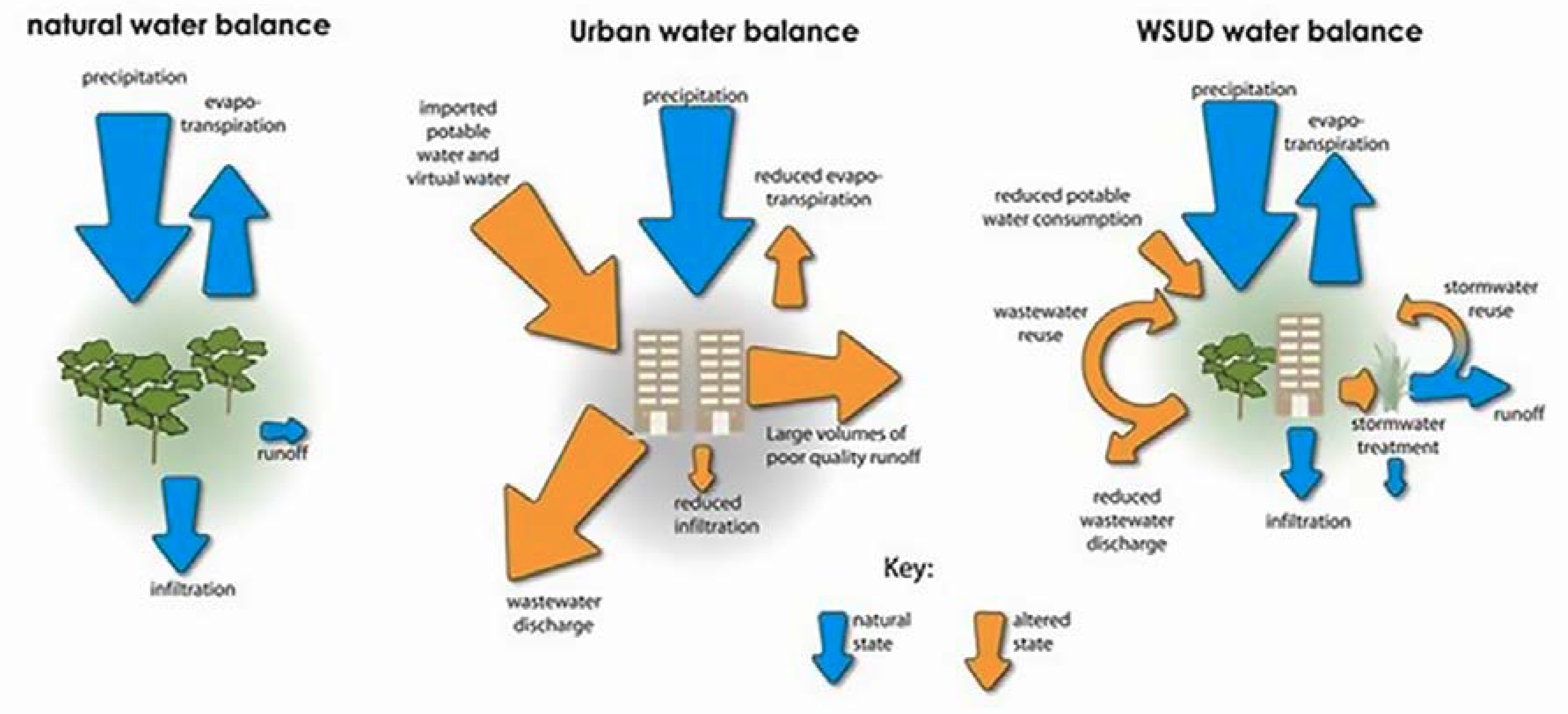
The WSUD approach describes the process that promotes a greater sensitivity to water in the UWC as an alternative to traditional water management approaches. By promoting harmony between natural and urban processes, it seeks to restore the natural water cycle in the urban context, give access to different water sources, protect water bodies, and reduce the risks associated with extreme weather events [8]. Water is recognised as an essential asset that must be valued and integrated into the urban landscape. The creation of attractive spaces supports natural habitats and promotes biodiversity and community well-being [9]. The integrated management of the UWC is assured by the integration of WSUD principles, further increasing the evapotranspiration, infiltration, and drainage of stormwater runoff [10]. Figure 1 depicts the contributions of WSUD to the UWC.
The guiding principles of WSUD are to
- Incorporate water resources in the land use planning process;
- Address water resource issues at the catchment and sub-catchment level;
- Ensure water management planning is precautionary and recognises intergenerational equity, conservation of biodiversity, and ecological integrity;
- Recognise water as a valuable resource and ensure its protection, conservation, and reuse;
- Recognise the need for site-specific solutions and implement appropriate non-structural and structural solutions;
- Protect ecological and hydrological integrity;
- Integrate good science and community values in decision making;
- Ensure equitable cost-sharing [10].
Achieving the objectives inherent to a WSUD strategy requires planning that considers the protection, maintenance, and improvement of the multiple benefits and services of the UWC. It requires more than just structural components (e.g., grey infrastructure relating to hydraulic engineering infrastructures, and green components, such as interventions that incorporate vegetation). Regulatory standards and educational programs are needed to guarantee a greater degree of effectiveness in implementing sustainable strategies. To ensure the management of the UWC, it is essential that both structural and non-structural BMPs. BMPs must consider the city’s climatic and geographic context, and their implementation has to follow sustainable and precautionary principles [10,12].
Structural BMPs concern the structures to manage the quality and quantity of runoff by controlling, treating, or preventing stormwater pollution. The integration of structural BMPs allows for creating and improving public green areas for recreation and leisure. Structural control elements can be classified according to their location (e.g., upstream, or downstream), function (e.g., water quantity or quality), and treatment stage (e.g., primary, secondary, or tertiary). They must be used in combination as part of a treatment train and installed as close as possible to the source of runoff, thus ensuring a reduction in the volume of stormwater pollutants along the watershed to protect the receiving water bodies [10,13]. Structural elements can be designed for new urban areas but can also be used for urban retrofitting. To guarantee the effectiveness of structural BMPs, one should combine these with non-structural best practices. Non-structural BMPs are related to institutional and pollution prevention practices developed to prevent or minimise stormwater contamination and reduce the stormwater volume that flows into the treatment train. Non-structural measures do not involve fixed or permanent infrastructure and usually are implemented through behavioural changes and municipal governance practices (environmental policies and spatial planning). Increased awareness and literacy of users about the importance of BMPs contributes to the efficient use of water and prevents stormwater contamination [6,12].
The selection of structural and non-structural BMPs presented in Table 1 considers the focus, scale application, and possible implementation limitations of the BMPs.
This work’s main objective was to promote the integrated and sustainable management of the UWC in Quarteira (Loulé’s municipality) by developing a strategy that capitalises on WSUD BMPs to guide the city’s transition to a WSC. The proposed plan takes advantage of WSUD BMPs, both structural and non-structural. By focusing on the critical areas identified in the study area, this strategy promotes the city’s resilience and adaptation in the face of climate change and simultaneously, fosters community engagement, and creates an awareness of the management of the UWC.
With the development of this strategy, we intend to address the adaptation options present in the EMAAC of Loulé for the sectors of water resources management, land-use planning, and cities.
The study area, located in the south of Portugal (Algarve), is characterised by a Mediterranean climate with dry and warm summers and mild wet winters [14]. The region is exposed to several climate vulnerabilities, which are expected to be exacerbated in the context of climate change. These changes will have impacts on different areas and socio-economic sectors in the region. In recent years, the Algarve region has faced climatic events related to heatwaves, forest fires, floods and rapid floods, coastal overtop, and coastal erosion [15].
2. Material and Methods
2.1. Study Area
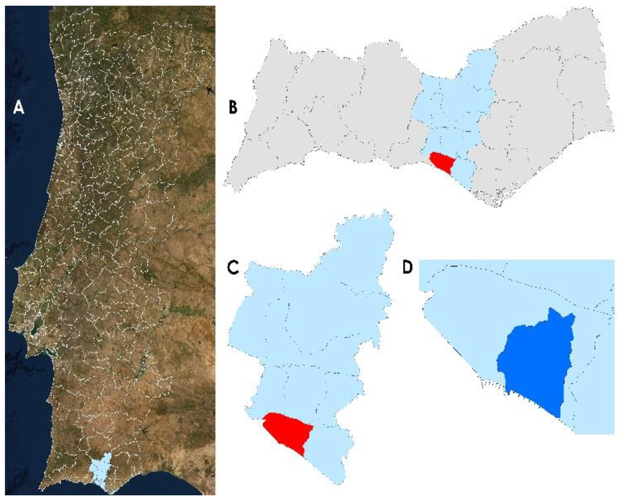
The territory in study, the watershed of Quarteira, lies in the most coastal strip of Loulé’s Municipality in southern Portugal (A), as shown in Figure 2. Quarteira is currently the most populous parish in Loulé’s Municipality (C), with an estimate of 22,000 inhabitants and a population density close to 600 inhabitants/km2. It has been recognised since the 1980s as one of the most representative tourist sites in the Algarve. Since the end of the 20th century, urban areas’ growth has led to an increase in population, further motivated by the real estate boom due to tourism.
The urban area of the city of Quarteira is characterised by its high level of infrastructure and building concentration, contributing to the increased level of imperviousness in downtown areas. When combined, these factors contribute to urban floods in these areas that are more vulnerable to the impacts of extreme precipitation events [16].
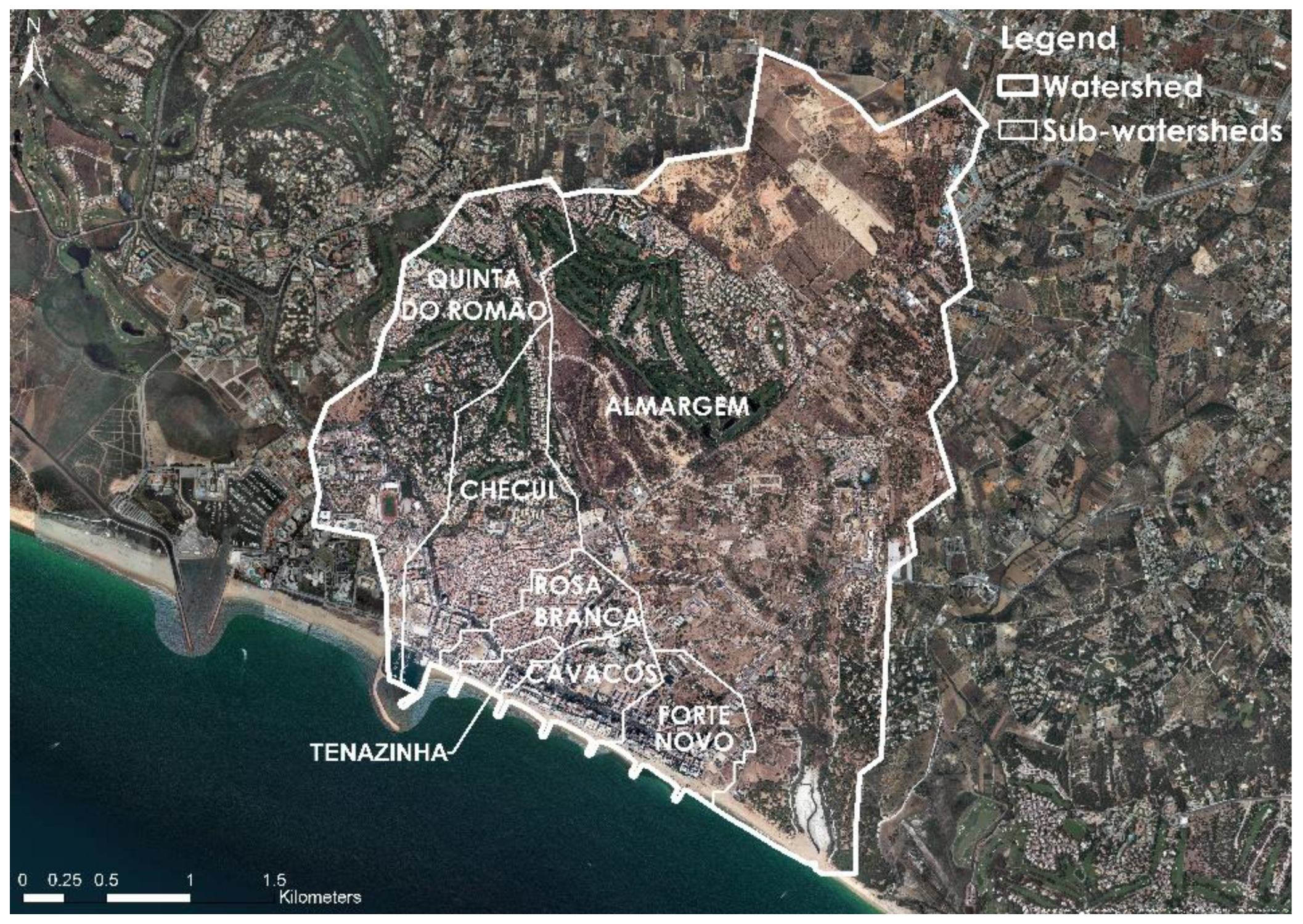
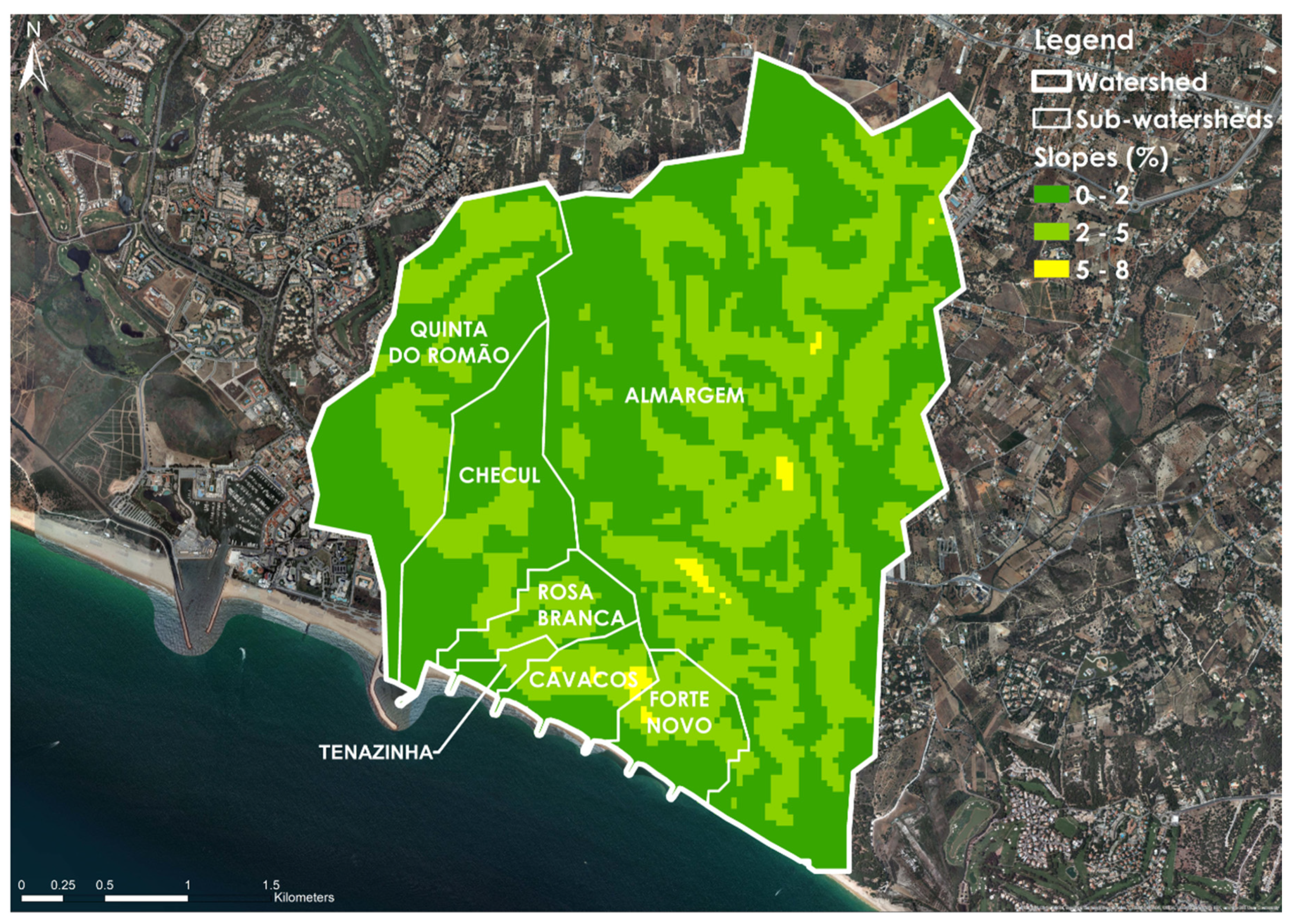
The watershed dominating the city of Quarteira has an area of 12.1 km2 that corresponds to 32% of the area of the parish area of Quarteira. Figure 3 identifies the main watershed and sub-watersheds, namely, Almargem (7.8 km2), Cavacos (0.4 km2), Checul (1.2 km2), Forte Novo (0, 5 km2), Quinta do Romão (1.8 km2), Rosa Branca (0.4 km2), and Tenazinha (0.1 km2). In the watershed, we also identified the water streams, fluvial-lagoon system, and drainage area.
2.2. Methodology
The methodology adopted for the elaboration of this study was centred on the following tasks: (1) assessment of the EMAAC of Loulé, (2) identification of the study area watershed, (3) characterisation of the study area—Quarteira watershed, (4) state-of-the-art review, (5) development of a diagnosis of the study area, (6) community participation surveys, (7) definition of a transition strategy for the transition of Quarteira into a WSC, (8) identification of suitable sites for the implementation of structural BMPs, and (9) geolocation of proposed structural BMPs for each sub-watershed.
2.2.1. Assessment of the EMAAC of Loulé
We began by assessing the EMAAC of Loulé and the local climatic impacts profile of Quarteira (PIC-L of Quarteira) to identify the climatic projections, vulnerabilities, future and current impacts, and adaptation strategies for the Municipality of Loulé. Moreover, we identified and selected the adaptation strategies present, considering their correlation with this work objectives, to further support the transition strategy’s development.
2.2.2. Identification of the Study Area Watershed
To perform this task, we employed a set of geospatial elements of the parish of Quarteira provided by the Municipality of Loulé (CML), namely, elevation points and contour lines shapefiles. These elements were then used to supply the Hydrology toolset in ESRI ArcGIS ArcMap programme for identifying the watershed directly influencing the urban areas of Quarteira.
2.2.3. Characterisation of the Study Area
The characterisation of the study area resulted from the assessment of the information present in the characterisation studies developed for the major review of Loulé’s Master Plan (PDM of Loulé), available on the website of the CML. In this task, we identified the existing spatial planning instruments and abiotic, biotic, and cultural resources for the study area, with capacity to leverage the development of the transition strategy’s.
2.2.4. State-of-the-Art Review
In the state-of-the-art review, we identified the suitable WSUD BMPs according to the technical information available in the following guides: Water Sensitive Urban Design Technical Design Guidelines for South East Queensland, Water Sensitive Urban Design—Greater Adelaide Region Technical Manual, and the Evaluating Options for Water Sensitive Urban Design—A National Guide.
2.2.5. Diagnosis
The development of the diagnosis of the study area consisted of 2 complementary steps. We started by taking advantage of the Hydrology toolset’s outputs in task (2) for identifying the drainage network and respective pour points. These results allowed us to locate flood-prone areas in urban land-use zones. We then validated these results through the PIC-L of Quarteira dataset, historical records, and hydrometric data from a precipitation event from March 2020. The next step of the diagnosis consisted of a comprehensive analysis of the elements gathered in tasks (1), (3), and (4) and the outputs produced in task (2). These elements were then arranged for producing a SWOT (strengths, weaknesses, opportunities, threats) analysis. The results of this analysis were further refined and used to support the development of the transition strategy.
2.2.6. Community Participation Surveys
Together with the OUACEC of the CML, we developed a survey to consummate community participation in the transition strategy, bringing together the community’s aspirations and needs. The survey was divided into 5 sections. In the first section, respondents identified the scope of their response. In the second and third sections, sociodemographic and institutional data were collected. The fourth section presented the concept of WSC, where we assessed the awareness of survey respondents to the WSC concept and its multiple benefits. In this section, respondents were also asked to identify the possible constraints to the transition process. The work objectives were presented in the last section, along with the main structural BMPs. Survey respondents were asked to identify areas subjected to frequent urban floods and indicate which structural BMPs can mitigate the presented impacts. The final section of the survey was open to commentaries and suggestions for improving the transition to a WSC. The survey was disseminated through municipal services to the Local Monitoring Board (CLA) of the EMAAC of Loulé, University of the Algarve (UAlg) professors in the M.Sc. in Urban Water Cycle and individuals with a particular interest in urban water management in Quarteira.
2.2.7. Definition of a Transition Strategy for the Transition of Quarteira into a WSC
The proposal developed for the transition of Quarteira into a WSC was built on three pillars: (i) city as a watershed, (ii) city as a source of ecosystem services, and (iii) a city comprising water-sensitive communities [5]. In this sense, we advanced with the development of a transition strategy built upon structural and non-structural BMPs identified in task (4) supported by the outputs from task (5).
2.2.8. Identification of Sites for the Implementation of Structural BMPs
In this task, we identified suitable sites in the study area to implement structural BMPs. To achieve this, we used the Quarteira Green Area’s dataset. This dataset, provided by the CML, contained the location of existing green areas in Quarteira. These sites were later validated through field visits carried out by the team and further geolocated these sites using ESRI ArcGIS ArcMap programme.
2.2.9. Geolocation of Proposed Structural BMPs
With the results produced in tasks (4), (5), and (8), structural BMP elements for each sub-watershed were proposed in line with the objectives set in task (7) and considering local characteristics. This task was developed using ESRI ArcGIS ArcMap program, where the georeferenced sites in task (8) were assigned with the selected structural BMPs in task (4).
3. Characterisation of the Study Area
3.1. Spatial Planning Instruments
In the study area, the main urban centres and economic activities that occur along the coast lead to harmful impacts on urban zoning, with increased tourism pressures on the urban and peri-urban fabric. Spatial planning instruments (SPIs) reflect the importance of guaranteeing that human activities balance people, territory, and goods. Land-use planning is governed by the National Spatial Planning Policy Program (PNPOT) at the national level. This national instrument influences territorial management instruments that intervene in more restricted thematic and geographical domains. The management of areas with greater capacity to maintain biophysical balance is regulated by the National Ecological Reserve (REN), an SPI of great relevance for the national territory’s environment and organisation. The National Agricultural Reserve (RAN) is a fundamental SPI for the defence and protection of the greatest agricultural aptitude areas considering the agro-climatic characteristics, topography, and soils. In the Algarve region, it is important to highlight the Regional Spatial Planning Plan for the Algarve (PROT-ALG) defining the regional strategy for land development. The management of the Algarve sensitive coastline is governed by the Coastal Planning Plan (POOC) Vilamoura—Vila Real de Santo António [17,18].
Water resources management in the Algarve region is regulated by the Algarve River Basin Management Plan (PGBH–RH8) [19]. This SPI aims to manage and protect water resources to reduce water scarcity risks and improve water resources ecological status. It promotes the environmental, social, and economic enhancement of water resources to ensure population well-being without jeopardising ecosystems services. The efficient use of water resources in the urban, agricultural, and industrial sectors is reflected in the National Program for the Efficient Use of Water (PNUEA), a national environmental policy instrument [20,21].
At the municipal level, zoning in Quarteira is regulated by the PDM of Loulé, developed to reinforce and ensure economic, social, and environmental development [22].
The presence of urban soils is characteristic throughout Quarteira’s watershed. The urban agglomerates occupy a large part of the coastal strip, although they are dispersed in patches of different dimensions in all sub-watersheds. Type-A urban agglomerates correspond to an area of 2.3523 km2 and are predominant in the sub-watersheds of Checul, Rosa Branca, Cavacos, and Forte Novo. In comparison, Type-A urban expansion areas represent a total of 0.4801 km2 in patches of different dimensions in the sub-watersheds of Quinta do Romão, Almargem, and Forte Novo. In the Almargem sub-watershed central area, non-residential areas, and a small patch of disperse urban areas are enclosed by RAN areas. Despite the great urban concentration of touristic infrastructures, urban green protection areas can be identified southwest of urban areas in Checul, and Quinta do Romão sub-watersheds. Urban green equipped areas correspond to golf courses in patches of different dimensions in tourism–urban areas in the north and northwest areas of the sub-watersheds of Quinta do Romão, Checul, and Almargem. The rural soils assigned to the area under study comprise forest protection areas, whose expression is evident in the quadrant northwest of Almargem sub-watershed. In the study area, the REN areas are in the watershed coastline and represent cliffs and respective protection bands, headwater streams, dunes/sandy cordons, streambeds, flood-prone areas, and beaches. The existence of agricultural areas corresponds to areas integrated into the RAN and flood-threatening areas found along the two existing water lines of the Almargem sub-watershed, Vala Real da Fonte Santa stream and its tributary, the Almargem stream.
The municipal spatial zoning plans (PMOT) are relative to the detailed plan (PP) present in Cavacos and Forte Novo’s sub-watersheds in Type-A urban agglomerates areas and Type-A urban expansion areas. Under development are the PPs located in the southernmost area of the sub-watersheds of Checul, Quinta do Romão, and Rosa Branca, in Type-A urban agglomerates and urban green protection areas. The intervention plan in rural areas (PIER) and the urbanisation plan (PU) are in development in the sub-watershed of Almargem. The latter also intersects the sub-watershed of Forte Novo. These plans are in Type-A urban agglomerates areas and Type-A urban expansion areas in a forested protection area.
The dominant land use capability class in the study area is divided between the De and Ds classes. These soils are characterised by their low use capacity, root zone limitations, and increased risks of erosion and runoff, not susceptible to agricultural use except in exceptional circumstances [23]. Their presence is felt throughout the watershed, overlapping both RAN and REN areas. Class A soils, with few or no limitations and a low risk of erosion, appears associated with valley areas in the sub-watershed of Quinta do Romão, Checul, Rosa Branca, and Tenazinha. These soils are found in Type-A urban agglomerates areas and Type-A urban expansion areas. With some limitations and moderate erosion risks, the class Bs occur along the two water streams in the sub-watershed of Almargem. The capability class Cs with moderate to high erosion limitations and risks occur in two small patches of Cavacos and Forte Novo sub-watersheds. Soils of class Es with very high erosion risks are identified along the coastal strip of all sub-watersheds and intersect an area of urban green protection common to the sub-watersheds of Checul and Quinta do Romão [23]. The class Eh with increased risk of flooding, is found in the margins of the lagoon system of Almargem sub-watershed in a REN area, contiguous to a forest protection area. The Ee class presents severe limitations and high erosion risks and is present in urban green equipped areas of urban tourist zones in the northwest sector of the sub-watershed of Almargem and the north sector of Quinta do Romão.
3.2. Abiotic Resources
- Climate
The study area climate is characteristic of the Mediterranean and is significantly influenced by its sea proximity. The large percentage of rainfall observed, about 75% to 85% of the total annual precipitation, occurs between October and March (rainy season). Precipitation records between July and August (dry season) total about 1% of the annual rainfall recorded. The average annual rainfall recorded at the nearest udometric station is about 450 mm, which may vary from year to year. An increasing trend in annual precipitation averages for more recent years has been observed. This occurs at the expense of an apparent greater irregularity of rainfall during the year and very concentrated rainfall, with a progressively more torrential character [20,22].
- Hydrography
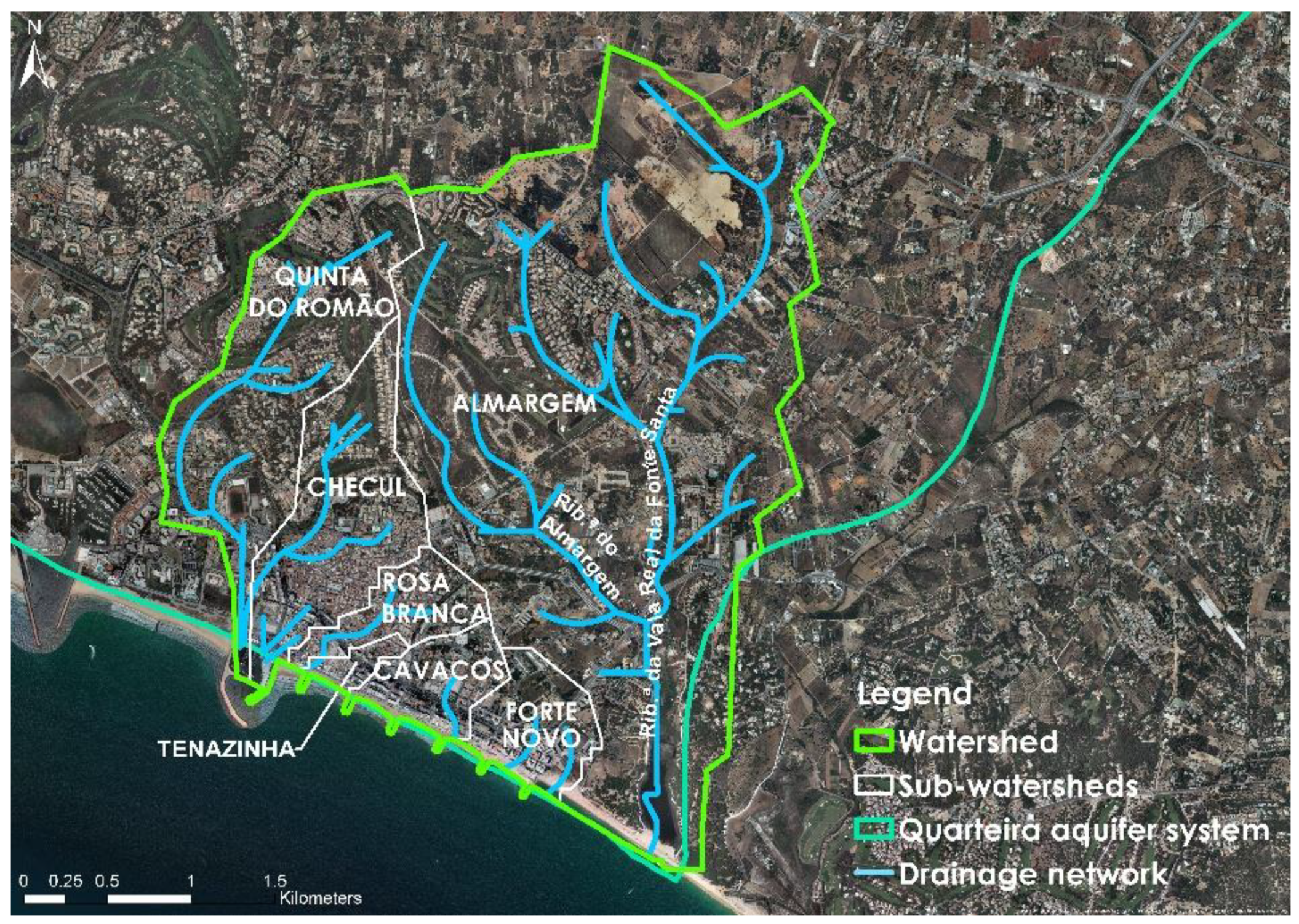
The study area’s main water line is the Vala Real da Fonte Santa stream and its main tributary the Almargem stream. These two surface water bodies are characterised by their ephemeral regime and are found in the sub-watershed of Almargem. Their presence is difficult to verify due to the low terrain slope and artificialisation of surrounding areas, only perceptible when continuous or torrential precipitation events occur [24]. The lagoon system, Foz do Almargem, is what remains of a small brackish water estuary, separated from the ocean by a narrow dune cord or fragile sandbanks that sands and alluviums have filled. This lagoon system’s morphology is profoundly impacted by intense anthropic interference (drainage and landfills) linked to agricultural activities and urban tourist expansion [20].
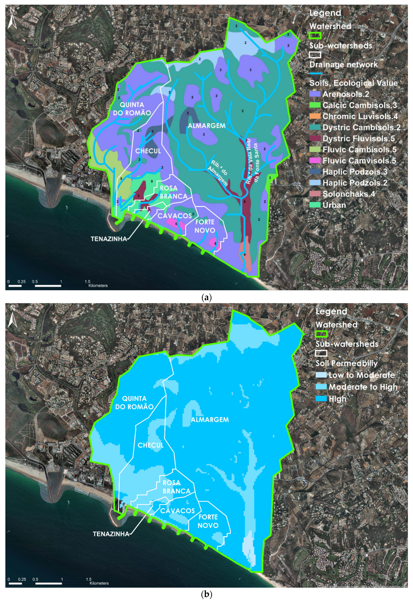
The Quarteira Aquifer system covers all the watershed. It is characterised by a complex multi-aquifer system consisting of simple or multilayer aquifers karstic types, others of the porous or mixed type, free and confined, sometimes of the artesian flow. It is important to highlight the phenomenon of saline intrusion, driven by population growth, urban pressure, and over-extraction of groundwater resources [22,24,25]. According to the PGBH–RH8, water bodies that do not constitute water sources for public supply are considered strategic reserves. Thus, these water sources play an important role as sources of water in periods of drought, and therefore the level of protection must be similar to current sources [19]. Figure 4 identifies the existing water bodies in the study area and the pre-development drainage network.
- Topography
Gentle slopes characterise the study area’s topography, oriented south and southwest in urban continuous fabric areas, with ridge lines present in the continuous urban fabric areas. The ridgelines occur in continuous urban fabric areas of the watershed. The land gradients vary from 0% to 8% in the urban fabric areas of Checul, Cavacos, Forte Novo, and Rosa Branca sub-watersheds, with a maximum height of 44 m (Figure 5). The land gradient is mainly oriented towards the south, determining the preferential direction of surface runoff. It is important to point out that the maximum land grades intersect the access avenues to downtown areas.
- Soils
The main classes of soils present in the study area and the soil’s ecological value are presented in Figure 6a. The soils potential permeability in the study area, shown in Figure 6b, considers the geological substrate’s influence, the soils, and the land gradient. The soil classification scheme used follows the Food and Agriculture Organization International Reference Base for Soil Classification and the Portuguese Soil Classification System [23,26,27].
Dystric Cambisols (Vt) (45.24%) soil occurs predominantly in the Almargem sub-watershed, and smaller patches occur in Quinta do Romão Checul, Cavacos, and Forte Novo sub-watersheds. Due to their low capacity to retain moisture, they have a low ecological value, but a relatively high permeability [23,28]. Incipient soils represent approximately 42.24% of soil classes in the study area. Arenosols (Rg) predominate within this class, which appear in patches of different dimensions, most expressive in the upstream northwest to southeast quadrants. Most of them have low moisture retention capacity and thus low ecological value, but high permeability. Dystric Fluvisols (A) are identified in an area common to the sub-watersheds of Checul, Rosa Branca, and Tenazinha, in a natural water accumulation area. The Dystric Fluvisols (Aac), with very high ecological value and moderate to high permeability, are present in areas threatened by floods, identified in the Almargem sub-watershed, along the existing streams. Fluvic Cambisols (Atl) are also identified in four small patches along the sub-watersheds of Checul, Cavacos, Forte Novo, and Quinta do Romão. These soils have the highest ecological values for the study area and a moderate to high potential permeability [20,23]. The Haplic Podzols (Pz, Ppt) soils have a low to variable ecological value and moderate to high permeability. Their presence represents an area corresponding to 6.82% of the watershed and are distributed in several small patches in the sub-watersheds of Almargem, Checul, and Quinta do Romão. Solonchak soils (0.88%) can be found in the Almargem lagoon area in the Almargem sub-watershed and are characterised for their low potential permeability and high ecological value [28]. The Calcic Cambisols (Pc) occupy only a small strip to the east of the Almargem sub-watershed corresponding to 0.32% of the study area. They have a variable ecological value, but a high permeability, although dependent on the proportion of existing clays [23]. The Argiluviated soils have a high ecological value and moderate to high permeability, being the least representative class in the watershed (0.28%). They occupy a small area in the sector in the west of the watershed, present in a small spot in the sector bordering on the west of the Quinta do Romão sub-watershed.
3.3. Biotic Resources
- Biotopes and Habitats
The following biotopes were identified for the study area: riparian galleries, aquatic systems, permanent cultures, pine forest, annual crops, bush, dunes, and humanised and non-humanised green spaces. According to Brás et al. [24], for the watershed of Vala Real da Fonte Santa stream, partially covered by the sub-watershed of Almargem, one can identify 16 natural and semi-natural habitats of community interest [29].
- Flora and Fauna
The plant species identified in the study area correspond to those with heritage value or of interest for conservation in the study area, found along the Vala Real da Fonte Santa stream. With the intense urban development that guided the expansion of the city of Quarteira, changes in the natural flora became evident. Nowadays, many other plants, shrubs, and trees can be identified in natural surroundings or introduced as decorative elements in the city’s public infrastructures [20].
The fauna community identified for the study area identifies species belonging to the following groups: Ichthyofauna, Herpetofauna, Avifauna, and Mamofauna, characteristic of the study area biotopes [20].
3.4. Cultural Resources
- Land-use (1990–2005)
The comparative analysis of land-use changes between 1990 and 2005 shows the most significant differences between the two periods. The differences are due to the expansion of artificial areas, including built-up areas for infrastructures, as well as equipped urban areas. The more significant changes occurred in the continuous and discontinuous urban fabric, especially in the Almargem sub-watershed. The replacement of areas occupied by pine and cork forests and mixed orchards was mainly due to urban growth. Nonetheless, this growth was accompanied by an increase in artificial green spaces in the Almargem sub-watershed, namely, golf courses (included in the category of urban green spaces (non-forest) for sports activities), and led to the reduction of agricultural areas, related to areas of orchards [20].
- Urban Ecological Network (EEM)
For the characterisation process, the municipal EEM takes special relevance due to its relationship with this work objectives. In the study area, biotopes with high ecological importance, such as dunes, pine forests, forests, watercourses, and aquatic systems, were identified. In the urban areas, public parks and gardens are complemented by green spaces (not forest) for sports activities. As high landscape value elements, the sports equipment areas take significant importance. However, the existence of sand extraction areas north of the watershed contributes negatively to the landscape values [20].
4. Results and Discussion
4.1. Assessment of the EMAAC of Loulé
The EMAAC of Loulé arises from the municipality’s commitment and needs to respond to climate change by empowering the municipality and its natural and social systems given the climate projections, impacts, and vulnerabilities. The climate projections for Loulé’s Municipality refer to two climatic models and two scenarios (RCP4.5 and RCP8.5). These scenarios allow for the anticipation of a worsening of the impacts of the events related to the increase in temperature and frequency of heatwaves, greater intensity and frequency of droughts, and episodes of intense precipitation [15,22]. The ClimAdaPT.Local 2000-2014 project identified, for the EMAAC of Loulé, the adverse weather events and major impacts projected, which are hence present in the PIC-L of Quarteira [22].
The main climatic impacts projected to this area consist of
- Changes in biodiversity and in the environmental and natural heritage;
- Intensification of coastal erosion processes;
- Increase of flash floods;
- Restrictions on water supply and use;
- Changes in runoff and aquifer recharge;
- Decrease in the quality of water resources;
- Increased health risks;
- Changes in lifestyle.
Increased damage to equipment and infrastructures has occurred. The impacts and the respective effects of weather events identified in the PIC-L of Quarteira are a combination of damage to buildings and infrastructures caused by floods associated with extreme rainfall events, restrictions in water use and changes in the use of equipment and services in periods of drought, impacts on biodiversity, and increased risk of heat-related health problems linked to heatwaves [22].
The identified adaptation options from the EMAAC of Loulé are in line with the work objectives and allow us to act in response to the identified vulnerabilities and climate risks (current and future). The adaptation options were selected and refined, resulting in the options presented in Table 2.
We highlighted the transversality of the objectives inherent to the strategy proposed given the adaptation options present in the EMAAC of Loulé, demonstrating the importance of a holistic approach for the management of the UWC in the city of Quarteira.
4.2. Diagnosis
The first step of the diagnosis task derives from the Flow Accumulation tool’s outputs in the Hydrology toolset completed in task (2). These outputs allow us to have a clear view of the areas of surface runoff accumulation. This step aims to locate flood-prone areas, further validated by recurring to the PIC-L of Quarteira dataset, historical records, and a precipitation event that occurred during the development of this task.
The drainage network identified in Figure 4 demonstrates the natural drainage network in continuous urban fabric class areas with low potential permeability. As observed in Figure 4, land cover changes, driven by urbanisation processes, significantly changed the natural surface runoff [22].
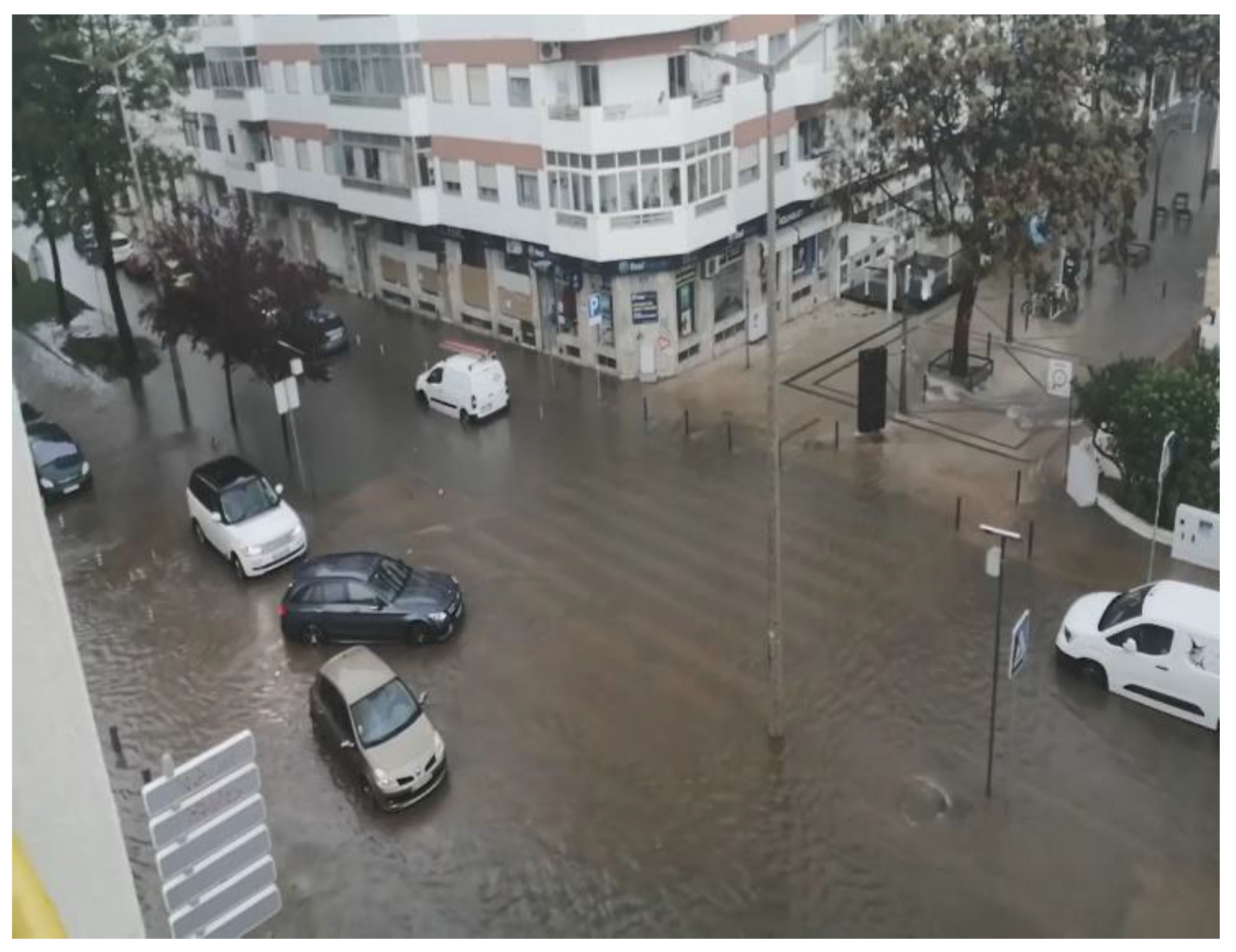
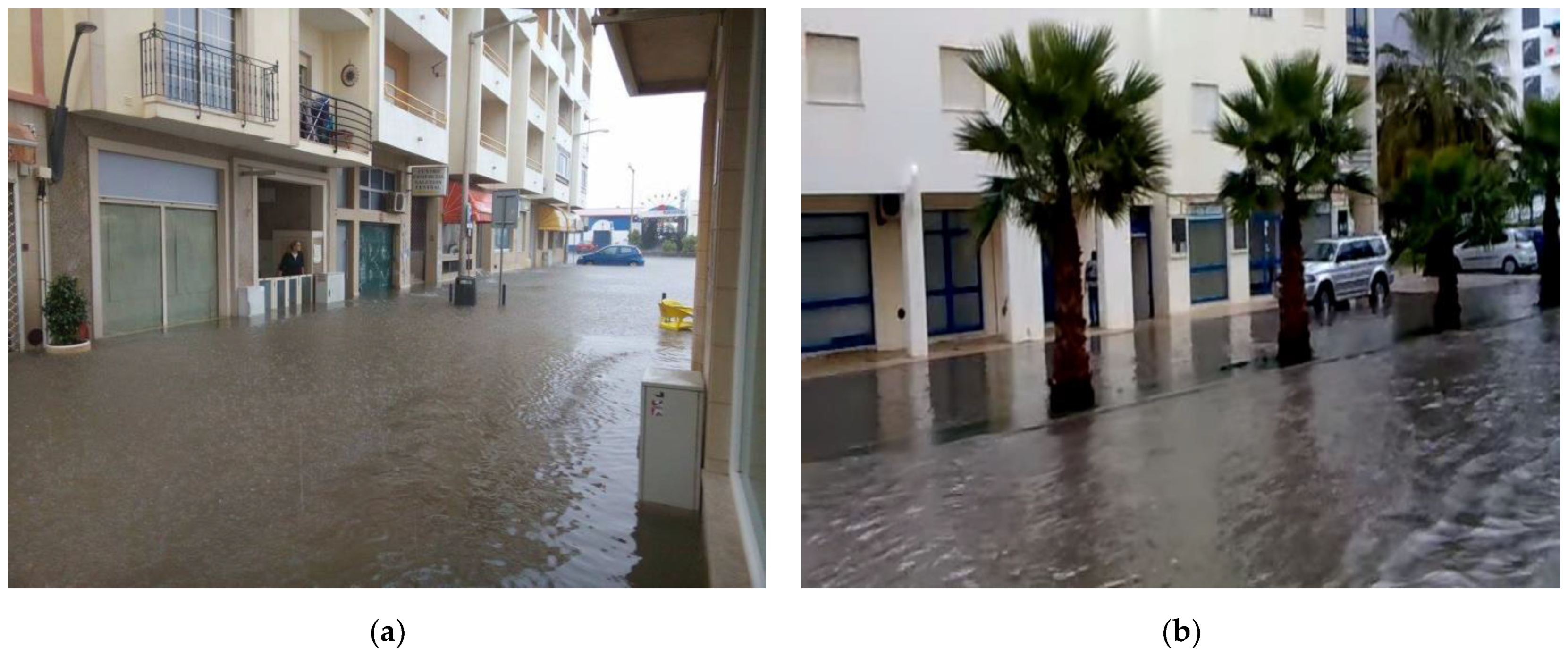
The PIC-L of Quarteira identified 17 extreme precipitation events from 2005 to 2016 that led to flash floods in various city areas. The impacts of these events affect the Checul sub-watershed predominantly, as seen in Figure 7 and Figure 8a [16]. We evidenced the influence of the land gradient and increased percentage of impervious areas in enhancing streets and avenues as drainage paths. The excessive accumulation of runoff in a cross-section of the Vasco da Gama St. (C4) with Carlos Mota Pinto Av. (C1) can be observed in Figure 7. The impacts of climatic extremes in downstream areas, Market Sq. (C1), and Cortes Reais Sq. (C3/RB1) are well documented, as is shown in Figure 8a.
The downstream areas of the Checul sub-watershed, namely, C1 and C3/RB1, are also under the influence of Bartolomeu Dias St. (deriving from the final section of C4 and Alagoa St. (C5). The Gonçalo Velho St. (RB8), in the Rosa Branca sub-watershed, also exerts a significant influence in the accumulation of surface runoff in C3/RB1. The combined effects of land gradient and the high percentage of sealed surfaces increase these areas’ vulnerability to urban floods dramatically. The outputs obtained also allowed us to identify another area considered critical in the Forte Novo sub-watershed, namely, in Rising St. and Southeast St. (F3), where floods are less frequent. However, their impacts are demonstrated in Figure 8b.
Following our diagnosis, on 20 March 2020, a precipitation event, with 4 h of low to moderate precipitation (with a maximum net intensity of 2.9 mm/h and total accumulated precipitation of 22.9 mm) resulted in accumulation of stormwater runoff in the intersection of C1 with C4 in the Checul sub-watershed, as observed in Figure 7 [33]. The effects of extreme precipitation events can also cause impacts along the entire downstream section of C4 and C1, as shown in Figure 8a.
The following step of the diagnosis consisted of producing a SWOT analysis with the elements collected in tasks (1), (3), and (8). For this analysis, we also relied on the diagnostic sheets developed for the major review of the PDM of Loulé [22,33].
The analysis is based on the strengths, weaknesses, opportunities, and threats regarding the abiotic, biotic, and cultural resources more relevant to developing the proposed transition strategy. The results obtained are presented in Table 3.
On the basis of this analysis, we found that the transition strategy development must take advantage of the SPIs in practice and natural and cultural resources. The element selection accounts for their aptitude and potential to tackle the city’s major issues and meet its inhabitant’s needs. The results of this analysis emphasise the potentialities of the resources present in the study area as transition drivers to implement a citywide strategy supported by structural and non-structural WSUD BMPs. Due to decreasing average annual precipitation, declining water stocks can have socio-economic and environmental impacts on the city’s liveability, stressing the need to implement a strategy based on structural and non-structural BMPs to promote rainwater harvesting and water use reductions.
The results obtained highlight the role of green spaces as a crucial element to preserve biodiversity, protect water bodies, and rehabilitate urban spaces using innovative solutions to mitigate the risks of urban floods and other impacts associated with new climate dynamics. The impacts of climatic extremes, such as torrential precipitation events, are directly related to urban flooding phenomena. Flood events are identified as one of the main challenges for UWM and raise issues regarding managing the quantity and quality of stormwater runoff. Downstream areas are significantly exposed to the impacts of floods, accompanied by declining water stocks due to decreasing average annual precipitation. Both these sources of pressure can have socio-economic and environmental impacts on the city’s liveability. All this emphasises the need to implement a strategy built on WSUD principles for achieving the holistic management of the UWC.
For this purpose, it is then necessary to promote the efficient use of water by advancing rainwater harvesting plans, grant fiscal incentives for the installation of water-efficient fixtures, and support the development of water reuse schemes. The integration of BMPs in urban development and rehabilitation plans will improve the existing ecological values and engage community participation in the UWC management processes.
4.3. Community Participation Surveys
For the development of a joint vision for Quarteira’s transition process, public participatory assemblies were foreseen. Unfortunately, given the context when these assemblies were scheduled (amidst the Corona virus disease 2019 - COVID-19 pandemic) it was only possible to conduct a survey. The survey was developed with the Municipal Council Operational Unit for Adaptation to Climate Change and Circular Economy (UOACEC) and then disseminated through CML services to community leaders, stakeholders, and local university members. The survey responses allowed us to validate the flood-prone areas identified in task (4) and were simultaneously used to develop the transition strategy in task (7).
Of the surveys sent via the CML services, only 13 answers were obtained, of which 11 were responded to by individuals and 2 by institutions. Respondents represented both city inhabitants and individuals whose professional activity takes place in or is related to Quarteira. The analysis of the results shows that, in a sample of 13 respondents, 61.5% said they know the concept of a WSC. For 84.6%, the transition of the city of Quarteira to a WSC will inevitably bring added value to the city and its inhabitant’s well-being. According to 92.3% of the respondents, the community has a decisive role in the transition process. As the main challenges to the transition process, 61.5% of the respondents identified resistances to behavioural changes and practices as a conditioning factor. However, 23.1% of the respondents answered that available financial resources pose the greatest obstacles to the transition process.
Most respondents (46.2%) identified the Checul sub-watershed as the most vulnerable to the impacts of extreme precipitation events, which agrees with the diagnostic results. The survey results were also important to identify other critical areas, namely, Patrão Lopes St. (C6); Nora St. located in the Tenazinha sub-watershed and complementary to Manuel Faria St. (CV3); and Infante de Sagres Av. (T2), in the seafront of the sub-watersheds of Checul, Rosa Branca, Tenazinha, Cavacos, and Forte Novo. Although these were not identified as critical in the diagnosis, they were flagged for their potential to mitigate the impacts of extreme precipitation events, and a treatment chain of structural BMPs were proposed. Of the total respondents, 92.3% foresaw that the implementation of structural BMPs has the potential to mitigate risks associated with extreme precipitation events, with only one respondent answering “perhaps”.
This survey was the first effort to foster community engagement. Given the lack of answers, we think the survey needs to be further refined to ensure clarity and conciseness. By doing so, we expect to reach a wider number of respondents. However, it allowed us to collect information regarding the respondent’s awareness concerning the UWC in the city of Quarteira and to validate and identify flood-prone areas. The results were considered for the development of task (7).
4.4. Definition of a Transition Strategy for Quarteira
The proposal developed for the city of Quarteira brings the current management model of the UWC as close as possible to that which characterises a WSC, built on three pillars: (i) city as a watershed, (ii) city as a source of ecosystem services, and (iii) a city composed of a UWC-sensitive community [4]. The transition strategy for Quarteira is based on the WSUD approach principles as an alternative to the traditional approach to UWM [34]. This strategy envisions the city’s future development towards a greater water-sensitivity, thus reflecting the opportunities identified in task (5). Increased city resilience and adaptation to climatic extremes impacts will facilitate the transition of Quarteira to a WSC.
The transition of Quarteira to a WSC takes advantage of WSUD structural and non-structural BMPs to develop intervention strategies and an intervention approach. In this sense, the integration of WSUD BMPs in municipal policies for urban rehabilitation projects and community and stakeholder engagement is crucial to building momentum and commitment.
The intervention strategies, built upon non-structural BMPs, were developed to guide, and promote changes that cultivate the facilitating conditions towards a water-sensitive future. These strategies require sustainable management practices, dimensioning of urban water-sensitive elements, and community engagement approaches. The strategies were defined using the results obtained in tasks (5) and (6). Table 4 shows the proposed intervention strategies.
The intervention approach, represented in Figure 9, employs structural BMPs to manage stormwater runoff’s quantity and quality. The proposed elements follow an upstream-to-downstream approach to collect and retain stormwater in upstream areas to reduce the volume and velocity of runoff towards flood-prone areas downstream. Structural BMPs are thoroughly proposed for the selected areas in task (3), considering each sub-watershed’s characteristics. The proposed interventions aim to (i) increase the retention, collection, drainage, treatment, and infiltration of stormwater runoff along a treatment train; (ii) reduce the volume and speed of runoff; (iii) mitigate the impacts associated with climatic extremes; (iv) promote rainwater harvesting in buildings and open spaces; (v) reduce the use of potable water; (vi) guarantee multiple functions of public green spaces for the protection and enhancement of ecological corridors, biodiversity preservation, and requalification of the urban landscape; and (vii) promote community engagement and participation in the UWC management process. Consequently, the implementation of these BMPs also contributes to improving air quality and mitigates the effects of heatwaves and protects aquatic ecosystems. The following types of structural BMPs are proposed: gross pollutant traps, permeable pavements, rainwater harvesting systems, retention, detention basins, bioretention systems, and leaky wells.
4.5. Identification of Sites for the Implementation of Structural BMPs
Identifying suitable sites for implementing structural BMPs was completed using the Espaços_Verdes_Quarteira.xlsx dataset and the results from task (4). The dataset, provided by CML, contained Global Positioning System (GPS) coordinates of existing green areas in Quarteira. From this dataset, we identified and selected the following urban elements: service buildings, schools, avenues, streets, median strips, parking lots, public green spaces, tree beds and flower beds, and neighbourhoods. The selection of sites also considered urban elements absent from the dataset, namely, roundabouts and plazas. From all the selected sites, the Vala Real da Fonte Santa stream mouth, under the REN legal regime, was identified as a possible site for implementing passive structural BMPs. This aspect lacks a further assessment to evaluate the compatibility of the proposed intervention with this SPI.
The selection of these sites by considering the assessment results from task (4) and the field visits guarantees good compatibility between site and structural element characteristics. By using the ESRI ArcGIS ArcMap programme, we geolocated the sites by the team.
4.6. Geolocation of Proposed Structural BMPs for Each Sub-Watershed
From the proposed interventions for the sub-watersheds covered by the transition strategy, we selected four of the seven sub-watersheds more significant to achieve the intervention approach’s objectives. These areas share an increased level of infrastructure and building density with a high degree of soil sealing in areas susceptible to flooding phenomena.
4.6.1. Sub-Watershed of Checul
In the sub-watershed of Checul, we emphasised the presence of flood-prone areas, as illustrated in Figure 7, corresponding to mixed-use areas downstream, identified as Market Sq. (C2), Cortes Reais Sq. (C3/RB1), and Vasco da Gama St. (C4). The changes in land-use and land cover due to urban development have led to an increased percentage of impervious areas that negatively contributed to changes in the baseline surface runoff of this sub-watershed.
The objective of the proposed BMPs is to mitigate the impacts of extreme rainfall events by reducing stormwater velocity and runoff accumulation in downstream areas. We highlight the role of green areas upstream and existing residential buildings.
4.6.2. Sub-Watershed of Cavacos
In the Cavacos sub-watershed, we highlight the presence of urban voids and open public spaces in areas with a slope gradient of 8%, and the occurrence of areas with a high degree of soil sealing, with impacts on the area’s hydrological processes. The drainage area, illustrated in Figure 11, originating in the urban void upstream of Francisco Sá Carneiro Av. (T4), increases the vulnerability to flooding of residential, commercial, and service areas located downstream. The soil has medium to high permeability; thus, retention and infiltration measures can reduce stormwater runoff.
The objectives of proposed structural BMPs are to decrease flow velocity and reduce stormwater runoff accumulation in downstream areas. To achieve this, we stress the capacity of existing urban and road infrastructures.
4.6.3. Sub-Watershed of Forte Novo
The Forte Novo sub-watershed shares similar characteristics with the sub-watershed bordering the west. The land gradient is slightly oriented to the southwest and west, with a maximum slope grade of 8% upstream. In this sub-watershed, the contribution of green open areas and residential buildings for source control upstream and downstream is emphasised.
The objectives defined for this sub-watershed reflect the need to introduce stormwater management BMPs to decrease the velocity and accumulation of stormwater runoff downstream in urban mixed-use areas. The impacts are evident when observing urban floods recorded along the adjacent streets, Rising and Southeast (F3), respectively, illustrated in Figure 7.
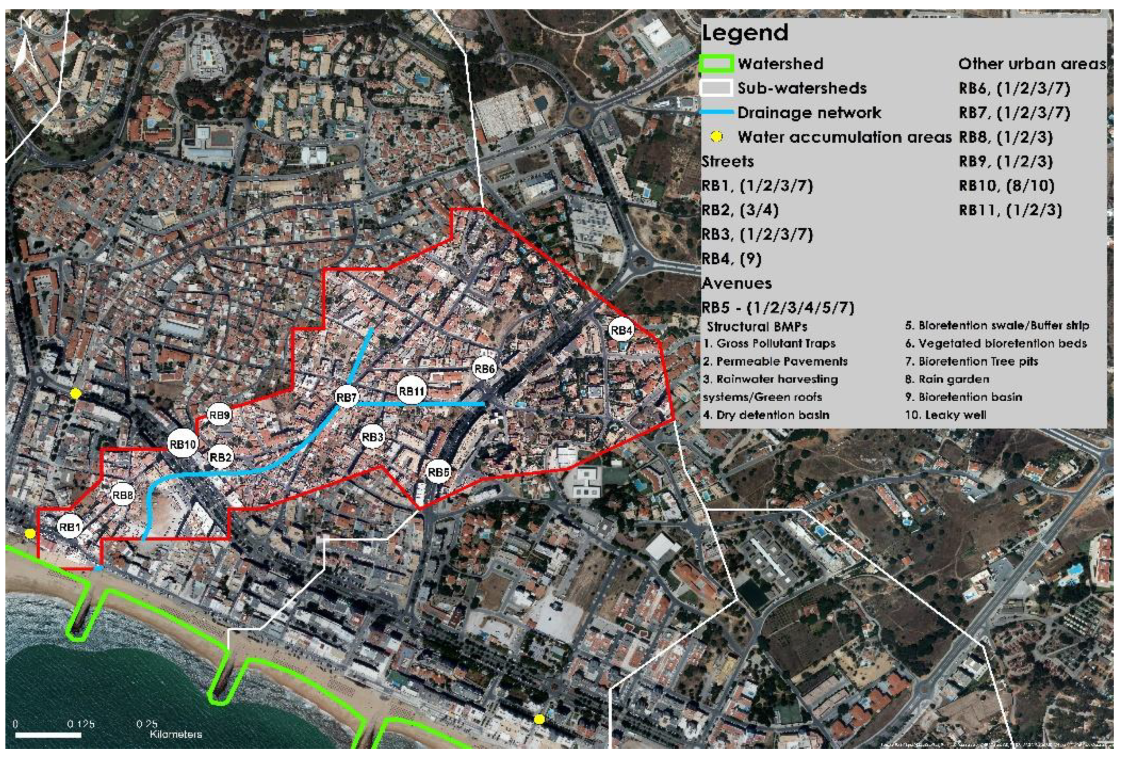
4.6.4. Sub-Watershed of Rosa Branca
Rosa Branca sub-watershed is found on top of continuous urban fabric areas, characterised by increased soil imperviousness, highlighted by a drainage area upstream with soils with medium soil permeability and a slope grade of 5%, overlapped by Farol St. (RB11). This flow accumulation area is covered by Cabin St (RB7) and Ribeiro St., flowing towards Gonçalo Velho St. (RB8), Av Francisco Sá Carneiro (T4), and Market Sq. (C2), in areas for residential, commercial, and service purposes. The soil imperviousness degree, land gradient, and street intersections have a decisive action in the confluence of runoff in the areas further downstream.
In this sense, we propose structural BMPs to manage stormwater runoff quality and quantity as of close as possible to its source by taking advantage of the soil potential permeability upstream and existing urban infrastructures.
4.7. Recommendations
By demonstrating the applicability of WSUD for sustainable urban water management to tackle current and future challenges, we intend to provide the first step in the Algarve region towards becoming a water-sensitive region. The transversality of the key concepts presented in this work incorporated in adaptation strategies can be replicated in regions with similar characteristics. Given the region’s geographic and climatic context, adaptation strategies focused on sustainable urban water management can contribute to environmental equilibriums and foster socio-economic development. The integration of BMPs in all municipal activities is thus a prerequisite to ensure the transition towards a greater water-sensitivity.
A methodical adjustment of the proposed solutions relies on assessing the city’s water system’s behaviour after integrating new BMPs. By guaranteeing this, we will gradually promote better city-scale water management. An effective assessment of the implemented solutions can support the implementation and monitoring of sustainable UWC management strategies. Therefore, cooperation between universities and municipalities emerges as a crucial partnership for developing adaptation strategies.
Achieving a water-sensitive future requires that community and stakeholder aspirations and concerns be reflected in long-term objectives. Advancing towards the transition towards a WSC relies on the definition of phased and planned actions. Ensuring a transition strategy success gives priority to non-structural BMPs to facilitate the uptake of WSUD in municipal policies and development plans. Implementing structural BMPs results from increased awareness of the benefits of WSUD for socio-economic development and community well-being. Priority should be given to less energy-intensive and less expensive solutions. Developing a city-scale WSUD strategy must set management targets and use suitable metrics to quantify the progress towards the transition to a WSC [35].
5. Conclusions
This plan is designed to support the promotion of adaptation to climate change in harmony with the adaptation options present at EMAAC of Loulé and aims to be a driving force to incite the transition of Quarteira city to a WSC [30].
The development and implementation of a WSC results in complex interactions between key actors and local features, and thus a proactive attitude towards this new urban water management paradigm is fundamental, making the challenge as social as it is technological. Overcoming these challenges requires developing new communication approaches through a collaborative attitude, founded on long-term objectives commonly accepted by the various actors, and characteristic of a greater sensitivity to water. Urban design practices should provide technically robust solutions to respond to present and future challenges, engaging community participation while providing multiple benefits beyond sustainability [7]. Community literacy and political support are essential to achieve this transition, particularly in complex urban environments such as Quarteira.
The proposed BMPs, associated with conventional water drainage techniques, can improve the city capability to adapt and mitigate urban risks inherent to the management of the UWC. The holistic management of the UWC should integrate urban water management in its three domains, potable water, wastewater, and stormwater, which include its efficient use, storage, treatment, and reuse to maximise the environmental, cultural, recreational, and economic value of water. The transition towards a water-sensitive future as an alternative to the traditional urban water management approach requires a phased and coordinated application of the proposed measures. In the transition context, appropriate assessment methods must be designed to measure and guarantee the adoption and implementation of measures defined over the long term [7].
The management of the UWC demands a comprehensive analysis of water flowing into and out of the city. Thus, the development of a city water balance is crucial to quantify water flows in and out of the city and to provide information regarding flow data showing how much water is needed for different uses, allowing for the establishment of water consumption targets for different time horizons [36].
Following the transition strategy, the development of local guiding norms for implementing BMPs should be enacted in consonance with the objectives set. Therefore, these objectives should be reflected when discussing whether a stormwater management plan should be enforced to manage the quantity and quality of stormwater flowing into drainage systems and be discharged into receiving water bodies. The stormwater management plan defines medium-to-long-term objectives regarding the quantity and quality of stormwater, where the implementation of structural BMPs plays a fundamental role. The assessment of these elements’ performance must be considered in the plan. The use of indicators ensures their operationality and effectiveness to achieve design objectives, which need to be previously estimated by simulating urban stormwater structural BMPs with stormwater modelling tools [36].
The transition path implies a dynamic process where management and planning approaches require a holistic perspective on water and land management. Thus, it is important to design land-use matrixes that identify urban areas capable of supporting specific land-use practices that foster environmental benefits and guarantee the sustainable use of future developed areas. For this strategy’s success, it is important to include the existing stormwater drainage infrastructures, which need to be surveyed using GIS tools to guarantee their maintenance and operation in parallel with structural BMPs in the city’s stormwater management plan. The need to establish other approaches that engage public participation is evident, as demonstrated by the survey’s poor adherence. Approaches that consider community aspirations and concerns, developed in cooperation with community leaders and stakeholders, should aim at increasing community literacy and participation in the management of the UWC by demonstrating the environmental, economic, and social benefits of WSUD. Implementing structural BMPs in urban areas should focus on results that reflect the community’s goals and needs so that the founding pillars of a WSC can be established.
This work appears as the first work plan developed in the Algarve region to address adaptation to climate change from an urban water management and spatial planning perspective. It should be noted that this preliminary plan lacks adjustments and phased programming in the respective implementation. This work’s delivery aims to be a driver of change and an example of best practices in the transition to greater water sensitivity. It is expected that other cities in the region, which share many of the vulnerabilities and impacts identified here, will follow the same transition path towards a water-sensitive region.
Author Contributions
Conceptualization, M.R.; methodology, C.A. and M.R.; software, M.R.; validation, C.A.; formal analysis, M.R.; investigation, M.R.; resources, M.R.; writing—original draft preparation, M.R.; writing—review and editing, C.A. and M.R.; visualization, M.R.; supervision, C.A. All authors have read and agreed to the published version of the manuscript.
Funding
This research received no external funding.
Informed Consent Statement
Not applicable.
Data Availability Statement
The data presented in this study are available on request from the corresponding author. The data are not publicly available due to copyright law compromise.
Acknowledgments
The authors would like to acknowledge the Operational UOACEC of the Municipal Department of Environment and Sustainable Development of the Municipal Council of Loulé for the support and for providing important elements for the development of this work.
Conflicts of Interest
The authors declare no conflict of interest.
References
- White, I. Water and the City: Risk, Resilience and Planning for a Sustainable Future; Routledge: London, UK, 2013. [Google Scholar]
- Howe, C.; Butterworth, J.; Smout, I.; Duffy, A.; Vairavamoorhty, K. Sustainable Water Management in the City of the Future: Findings from the SWITCH Project 2006–2011; UNESCO-IHE: Delft, The Netherlands, 2011. [Google Scholar]
- Gleick, P.H. Global Freshwater Resources: Soft-Path Solutions for the 21st Century. Science 2003, 302, 1524–1528. [Google Scholar] [CrossRef] [PubMed] [Green Version]
- Hoyer, J.; Dickhaut, W. Water Sensitive Urban Design for a Sustainable Stormwater Management in the City of the Future. In Proceedings of the 5th SWITCH Scientific Conference Sustainable Water Management in the City of the Future, Lodz, Poland, 13 October 2010; pp. 13–15. [Google Scholar]
- Wong, T.H.; Brown, R.R. The Water Sensitive City: Principles for Practice. Water Sci. Technol. 2009, 60, 673–682. [Google Scholar] [CrossRef] [PubMed] [Green Version]
- Lloyd, S.D.; Wong, T.H.; Chesterfield, C.J. Water Sensitive Urban Design: A Stormwater Management Perspective; CRC for Catchment Hydrology: Victoria, Australia, 2002. [Google Scholar]
- Brown, R.R.; Rogers, B.C.; Werbeloff, L. Moving towards Water Sensitive Cities: A Guidance Manual for Strategists and Policy Makers; CRC for Water Sensitive Cities: Victoria, Australia, 2016. [Google Scholar]
- Wong, T.H.F.; Allen, R.A.; Brown, R.R.; Deletic, A.; Gangadharan, L.; Gernjak, W.; Jakob, C.; Reeder, M.J.; Tapper, N.J.; Walsh, C.J. Stormwater Management in a Water Sensitive City: Blueprint 2013; The Centre for Water Sensitive Cities: Victoria, Australia, 2013. [Google Scholar]
- Hoban, A. Water Sensitive Urban Design Approaches and Their Description. In Approaches to Water Sensitive Urban Design; Elsevier: Amsterdam, The Netherlands, 2019; pp. 25–47. [Google Scholar]
- Bawden, T. Water Sensitive Urban Design Technical Manual for the Greater Adelaide Region. Aust. Plan. 2009, 46, 8–9. [Google Scholar] [CrossRef]
- Hoban, A.; Wong, T. WSUD Resilience to Climate Change. In Proceedings of the 1st international Hydropolis Conference; Stormwater Industry Association of Western Australia, Perth, Australia; 2006. [Google Scholar]
- Chalmers, L.; Gray, S. Stormwater Management Manual for Western Australia; Department of Environment Consultation and Guidance from the Stormwater Working Team: Perth, Australia, 2004. [Google Scholar]
- Hoban, A. The Water Sensitive Urban Design Technical Design Guidelines for South East Queensland; SEQ Healthy Waterways Partnership: Brisbane, Australia, 2006. [Google Scholar]
- Stigter, T.Y.; Varanda, M.; Bento, S.; Nunes, J.P.; Hugman, R. Combined Assessment of Climate Change and Socio-Economic Development as Drivers of Freshwater Availability in the South of Portugal. Water Resour. Manag. 2017, 31, 609–628. [Google Scholar] [CrossRef]
- Dias, L.F.; Aparício, B.; C Veiga-Pires, C.; Santos, F.D. Plano Intermunicipal de Adaptação Às Alterações Climáticas do Algarve, CI-AMAL (PIAAC-AMAL); CLIMAAA: Faro, Portugal, 2019. [Google Scholar]
- Câmara Municipal de Loulé. Perfil de Impactos Climáticos Local (PIC-L); Câmara Municipal de Loulé: Loulé, Portugal, 2016. [Google Scholar]
- Ministério do Ambiente e Ordenamento do Território e Desenvolvimento Regional; Comissão de Coordenação e Desenvolvimento Regional do Algarve. Plano Regional de Ordenamento do Território–PROT Algarve, Vol I-Plano; Comissão de Coordenação e Desenvolvimento Regional do Algarve: Faro, Portugal, 2007.
- Agência Portuguesa do Ambiente. Plano de Ordenamento de Orla Costeira Vilamoura-Vila Real de Santo António; Agência Portuguesa do Ambiente: Lisboa, Portugal, 2005. [Google Scholar]
- Administração da Região do Algarve, I.P. Plano de Gestão Das Bacias Hidrográficas Que Integram a Região Hidrográfica Das Ribeiras Do Algarve (RH8); Agência Portuguesa do Ambiente: Lisboa, Portugal, 2011. [Google Scholar]
- Câmara Municipal de Loulé. Estudos de Caracterização e Diagnóstico No Âmbito Da Revisão Do PDM de Loulé. Parte 2. Volume II–Análise Biofísica; Câmara Municipal de Loulé: Loulé, Portugal, 2009.
- Agência Portuguesa do Ambiente Plano Nacional Para o Uso Eficiente Da Água. 2012. Available online: https://www.apambiente.pt/_zdata/CONSULTA_PUBLICA/2012/PNUEA/Implementacao-PNUEA_2012-2020_JUNHO.pdf (accessed on 13 April 2019).
- Câmara Municipal de Loulé. Estratégia Municipal de Adaptação Às Alterações Climáticas de Loulé, CML (EMAAC de Loulé); Câmara Municipal de Loulé: Loulé, Portugal, 2016. [Google Scholar]
- IUSS Working Group WRB. International Soil Classification System for Naming Soils and Creating Legends for Soil Maps; Food and Agriculture Organization: Rome, Italy, 2015. [Google Scholar]
- Brás, L.; Santos, J.; Guerreiro, P.; Lopes, F.; Pereira, H.; Quinto-Canas, R.; Rosa-Pinto, J.; Pinto-Gomes, C.; Palma, L. Cadoiço e Foz Do Almargem; Associação Almargem: Loulé, Portugal, 2017. [Google Scholar]
- Comissão de Coordenação e Desenvolvimento Regional do Algarve. Plano Regional de Ordenamento Do Território Do Algarve. Vol. II–Caracterização e Diagnóstico. Parte 2. Anexo H–Recursos HÍdricos; Comissão de Coordenação e Desenvolvimento Regional do Algarve: Faro, Portugal, 2004. [Google Scholar]
- Leitão, M.; Cortez, N.; Pena, S. Valor Ecológico Do Solo de Portugal Continental. LEAF/ISA/ULisboa EPIC WebGIS. 2013. Available online: http://epic-webgis-portugal.isa.ulisboa.pt/ (accessed on 13 April 2019).
- Cardoso, J.C. A Classificação Dos Solos de Portugal–Nova Versão. Bol. Solos 1974, 17, 14–46. [Google Scholar]
- Ferreira, A.M.P.J. Dados Geoquímicos de Base de Sedimentos Fluviais de Amostragem de Baixa Densidade de Portugal Continental: Estudo de Factores de Variação Regional. Ph.D. Thesis, Universidade de Aveiro, Aveiro, Portugal, 2000. [Google Scholar]
- Directive, H. Council of Europe Council Directive 92/43/EEC of 21 May 1992 on the Conservation of Natural Habitats and of Wild Fauna and Flora. Off. J. Eur. Union 1992, 206, 7–50. [Google Scholar]
- Leininger, C. Cheias Na Rua Vasco Da Gama. Available online: https://www.facebook.com/groups/517048578413405/?post_id=2800865486698358 (accessed on 7 March 2020).
- Monteiro, H. Chuvas Fortes Causam Inundações No Algarve; Sul Informação: Faro, Portugal, 2015. [Google Scholar]
- Medina, L. Cidade de Quarteira. Available online: https://algarvemeualgarve.blogspot.com/2016/04/cidade-de-quarteira.html (accessed on 7 March 2020).
- Câmara Municipal de Loulé. Fichas de Diagnóstico Dos Estudos de Caracterização e Diagnóstico No Âmbito Da Revisão Do PDM de Loulé; Câmara Municipal de Loulé: Loulé, Portugal, 2009. [Google Scholar]
- Rodrigues, M. Water Sensitive Urban Design Para a Criação de Uma Water Sensitive City. Caso de Estudo: Quarteira. Master’s Thesis, Universidade do Algarve, Faro, Portugal, 2020. (In Portuguese). [Google Scholar]
- Lloyd, S.; Wong, T.; Blunt, S. Water-Sensitive Cities: Applying the Framework to Melbourne. Australas. J. Water Resour. 2012, 16, 65–74. [Google Scholar] [CrossRef]
- Melbourne Water. City of Melbourne WSUD Guidelines; Melbourne Water: Melbourne, Australia, 2015.
Figure 1.
The water balance under the water-sensitive urban design (WSUD) approach [11].
Figure 1.
The water balance under the water-sensitive urban design (WSUD) approach [11].

Figure 2.
Location of the watershed dominating the city of Quarteira (D) in Quarteira’s parish (C). Loulé’s Municipality in the Algarve (B), Portugal (A).
Figure 2.
Location of the watershed dominating the city of Quarteira (D) in Quarteira’s parish (C). Loulé’s Municipality in the Algarve (B), Portugal (A).

Figure 3.
Dominant watershed of the urban area of the city of Quarteira and sub-watersheds.

Figure 4.
Hydrography of the study area.

Figure 5.
Hydrography of the study area.

Figure 6.
(a) Soil classes present in the study area; (b) soil potential permeability of the study watershed.
Figure 6.
(a) Soil classes present in the study area; (b) soil potential permeability of the study watershed.

Figure 7.
Impacts of stormwater runoff accumulation in the intersection of C4 with C1 [30].
Figure 7.
Impacts of stormwater runoff accumulation in the intersection of C4 with C1 [30].

Figure 8.
(a) Floods in Vasco da Gama St. (C4) and in Market Sq. (C1) [31]; (b) flood event in the contiguous Rising St. and Southeast St (F3) [32].

Figure 9.
Intervention approach for the transition of the city of Quarteira into a water-sensitive city (WSC).
Figure 9.
Intervention approach for the transition of the city of Quarteira into a water-sensitive city (WSC).

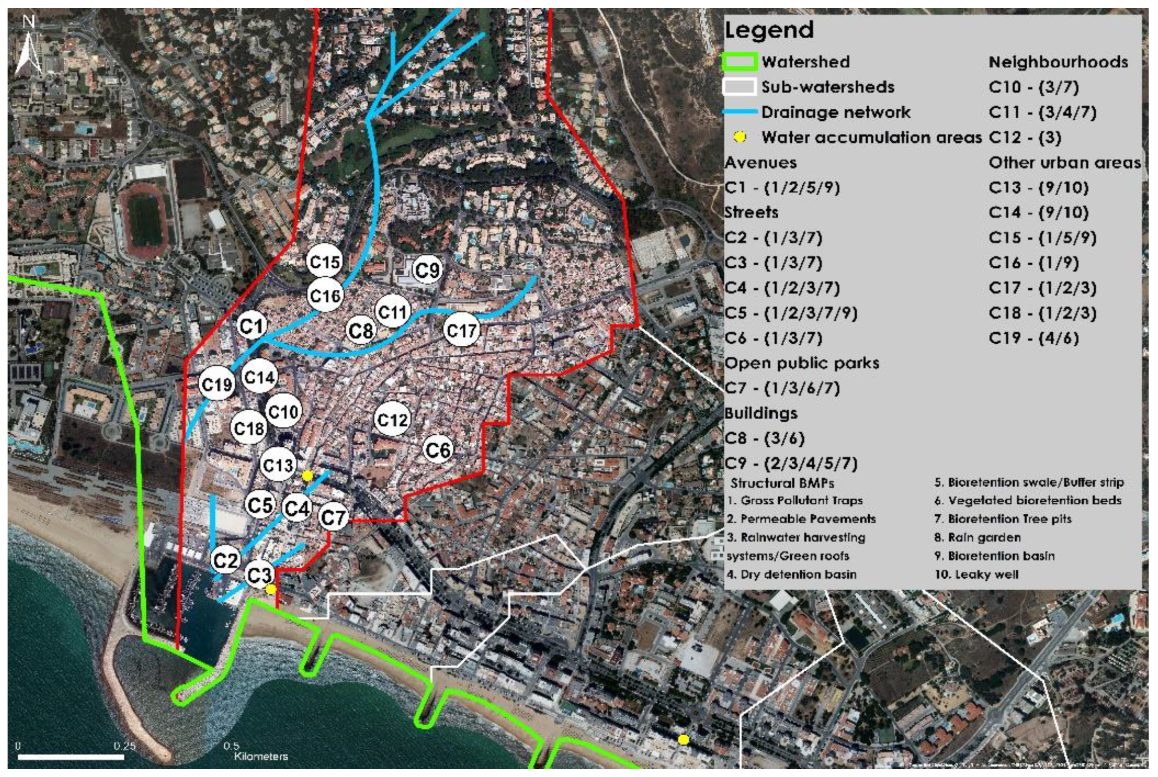
Figure 10.
Location of the proposed interventions in Checul sub-watershed.

Figure 11.
Location of the proposed interventions in Cavacos sub-watershed.

Figure 12.
Location of the proposed interventions in Forte Novo sub-watershed.

Figure 13.
Location of the proposed interventions in Rosa Branca sub-watershed.


Table 1.
Non-structural and structural best management practices (BMPs): focus, scale application, and constraints [10,13].
| BMPs | Focus | Scale of Application | Limitations | |
|---|---|---|---|---|
| Water Quality | Water Quantity 1 | |||
| Non-Structural | ||||
| Demand management | Low | High | Residential, commercial, and industrial sites. | Where water quality does not meet end use requirements. |
| Urban water harvesting and reuse schemes | Medium | High | Residential, commercial, and industrial. Generally, more viable for precinct scale sites. | Locations where demand is limited or adverse impacts to downstream users. |
| Structural | ||||
| Gross pollutant traps (GPTs) | High | Low | Site and precinct scale. | Sites larger than 1 km2. Natural channels. Low lying areas. |
| Permeable pavements | High | Medium | Allotments, roads, and car parks. | Severe vehicle traffic movement and developing catchments with high sediment load. |
| Rainwater harvesting systems (RHS) | Medium | High | Proximity to roof. Suitable site for gravity feed. Need to incorporate into urban design. | Non-roof runoff treatment. Where tank water is not used on a regular basis. |
| Green roofs | Medium | Medium | Flat roofs, slopes up to 30 degrees. | Roofs that are not structurally suitable. |
| Buffer strips | High | Low | Flat terrain. | Steep terrain. |
| Sedimentation basins | High | Medium | Need available land area. | Where visual amenity is desirable. |
| Bioretention systems | High | Low | Flat terrain. | Steep terrain. High groundwater table. |
| Bioretention swales | High | Medium | Mild slopes (<4%). | Steep slopes. |
| Rain gardens | Medium | High | Allotment scale. | Reactive clay sites. Near infrastructure. |
| Infiltration measures | High | Medium | Precinct scale. | Non-infiltrative soils. High groundwater levels. |
1 Peak flow attenuation in frequent events only.
Table 2.
Selected adaptation options from the EMAAC of Loulé in line with these work objectives [22].
Table 2.
Selected adaptation options from the EMAAC of Loulé in line with these work objectives [22].
| EMAAC of Loulé Adaptation Options |
|---|
| (#2/ID11) Develop and implement a municipal contingency plan for drought periods. |
| (#4/ID10) Design and implement a municipal programme for the efficient use of water. |
| (#9/ID19) Implement specific measures for flood risk management. |
| (#12/ID2) Design and implement education, awareness, and public information programmes on climate change, which can be extended to various sectors. |
| (#13/ID7) Reinforce green spaces and promote related environmental sustainability solutions/initiatives. |
| (#16/ID15) Incorporate criteria for adapting to climate change in municipal laws, policies, and plans. |
| (#17/ID27) Rehabilitate streams and associated riparian galleries. |
| (#25/ID26) Include in public contract procedures criteria that consider the issue of climate change. |
| (#28/ID20) Create, promote, and implement innovative sustainability strategies in an urban environment. |
Table 3.
SWOT (strengths, weaknesses, opportunities, threats) analysis.
| Strengths | Weaknesses | ||||
|---|---|---|---|---|---|
| Abiotic | Biotic | Cultural | Abiotic | Biotic | Cultural |
| Soils with moderate to high permeability. Presence of different water sources. | Natural and biodiversity resources in quantity and quality. Biotopes of ecological importance. | SPIs condition the use and interventions in urban and rural land. A municipal strategy for climate change adaptation. | Topography contributes to runoff. High degree of soil sealing. Increased water consumption in dry season. | Progressive degradation of environmentally sensitive areas. | Soil capability classes can limit the success of structural BMPs. Concentration of buildings in flood-prone areas. |
| Opportunities | Threats | ||||
| Abiotic | Biotic | Cultural | Abiotic | Biotic | Cultural |
| Rainwater harvesting and wastewater reuse for non-potable uses. Strategy for the preservation and protection of water bodies. Development of a stormwater management plan. | Foster biodiversity and promote the protection of native vegetation. Maintain and improve the landscape and ecological values. Improve streets and green areas with WSUD structural BMPs. | Rehabilitate urban areas with green spaces. Foster community participation in the UWC management. Preserve and maintain water systems. Demonstrate WSUD solutions to manage the UWC, mitigate flood risks, and prevent pollution of aquatic ecosystems. Encourage the acquisition of water-efficient fixtures and RHS. | Decreasing water reserves. Contamination of aquifers. Decreasing average annual rainfall. Increased frequency of extreme weather events. Soil desertification. Saline intrusion. | Increased urban sprawl. Degradation of natural systems due to human action. Increased anthropic pressure on natural ecosystems. | Progressive degradation of the built environment in public spaces makes future interventions more expensive. Damage to buildings and infrastructure associated with climatic extremes. |
Table 4.
Intervention strategies proposed for the transition of the city of Quarteira into a WSC.
| Intervention Strategies |
|---|
| Development of a stormwater management plan to manage the quality and quantity of stormwater runoff. |
| Reduce drinking water consumption through efficient water devices, stormwater harvesting systems, and greywater treatment and reuse. |
| Grant incentives for installing efficient water devices, stormwater harvesting systems, and greywater treatment and reuse systems. |
| Encourage the reuse of stormwater and recycled wastewater in a fit-for-purpose approach. |
| Communicate a narrative based on the environmental, economic, and social benefits of WSUD. |
| Preserve and maintain water systems, investing in their recovery and maintenance. |
| Encourage community participation in water-sensitive projects. |
| Maintain or improve the existing landscape and ecological values. |
| Minimise changes in natural topography. |
| Integrate structural BMPs aided by information elements related to their function into urban development and rehabilitation projects. |
| Test and demonstrate the benefits of implementing green infrastructures in the urban medium. |
| Protect the existing groundwater resources to prevent the advance of the saline wedge. |
Table 5.
Proposed structural BMPs for the Checul sub-watershed.
| Sub-Watershed ID | Summary Description |
|---|---|
| C1 | Carlos Mota Pinto Av.—Initial section: bioretention basin; crosswalks, permeable pavements; gutters: GPTs; median and side strips: bioretention swale. |
| C2, C3, C6 | Market Sq. (complementary to RB1), Cortes Reais Sq., and Patrão Lopes St.—Crosswalks and parking lots: permeable pavements; gutters: GPTs; tree pits: rehabilitation with bioretention functions; buildings: rainwater harvesting systems and green roofs. Storage in tanks or cisterns. |
| C4 | Vasco da Gama St.—Intersection with Av. Dr Carlos Mota Pinto, D. João V St., Hermenegildo Piedade St., and Gago Coutinho St.: permeable pavements and GPTs in gutters; buildings: rainwater harvesting systems and green roofs. Storage in tanks or cisterns; tree pits: rehabilitation with bioretention functions. |
| C5 | Alagoa St.—Parking lots and crosswalks: permeable pavements; gutters: GPTs; median strip: rehabilitation of tree pits with bioretention functions. End section: bioretention basin; buildings: rainwater harvesting systems and green roofs. Storage in tanks or cisterns. |
| C7 | Poeta Pardal Sq.—Gutters: GPTs; tree pits and garden beds: rehabilitation with bioretention functions; buildings: rainwater harvesting systems and green roofs. Storage in tanks or cisterns. |
| C8 | Checul Main Bldg.—Garden beds: rehabilitation with bioretention functions; building: rainwater harvesting systems and green roofs. Storage in tanks or cisterns. |
| C9 | Francisca de Aragão Elementary School—Garden beds: rehabilitation with bioretention functions; building: rainwater harvesting systems and green roofs. Storage in tanks or cisterns; playground (140 m2): dry detention basin; median strip in School St.: bioretention swale; crosswalk: permeable pavements. |
| C10 | IGAPHE and Miravila Neighbourhoods—Garden beds: rehabilitation with bioretention functions; buildings: rainwater harvesting systems and green roofs. Storage in tanks or cisterns. |
| C11 | Checul Neighbourhood—Garden beds: rehabilitation with bioretention functions; buildings: rainwater harvesting systems and green roofs. Storage in tanks or cisterns; playground (350 m2) and public garden (75 m2): dry detention basin. |
| C12 | Ribeirinho Neighbourhood—Building: rainwater harvesting systems and green roofs. Storage in tanks or cisterns. |
| C13, C14 | Checul and Polvo roundabouts—Rain garden; leaky well: receives the effluent from upstream treatment elements. The drainage system collects excess runoff. |
| C15, C16 | Areas marginal to Quarteira Rd.—Open green areas: bioretention swale and basin; GPTs in gutters and culvert. |
| C17, C18 | 25 de Abril and D. Dinis St.—Gutters: GPTs; crosswalks and parking lots: permeable pavements; buildings: rainwater harvesting systems and green roofs. Storage in tanks or cisterns. |
| C19 | Largo Dr. Diamantino D. Baltazar Sq. (550 m2)—dry detention basin; garden beds: rehabilitation with bioretention functions. |
Table 6.
Proposed structural BMPs for the sub-watershed of Cavacos.
| Sub-Watershed ID | Summary Description |
|---|---|
| CV1, CV2, CV3, CV13 | Regedor Sq., Mestre Luís St., Manuel Faria St., Morgadinho Neighbourhood—Tree pits and median strip: rehabilitation with bioretention functions; parking lots: permeable pavements. Gutter: GPTs; buildings: rainwater harvesting systems and green roofs. Storage in tanks or cisterns. |
| CV4 | Portas do Mar St.—Median strip: buffer strip; crosswalks and parking lots: permeable pavements; gutters: GPTs. |
| CV5 | Abertura do Mar St.—Tree pits and flower beds: rehabilitation with bioretention functions; buildings: rainwater harvesting systems and green roofs. Storage in tanks or cisterns. |
| CV6, CV7, CV16 | Toca St., Mata St., and Stuttgart St. (and intersection with Cap. Salgueiro Maia St.)—Parking lots: permeable pavements; gutters: GPTs; buildings: rainwater harvesting systems and green roofs. Storage in tanks or cisterns; rehabilitation of urban voids should include stormwater management BMPs. |
| CV10 | Kindergarten, public garden—Parking lots: permeable pavements; gutters: GPTs; garden beds: raingarden; tree pits: rehabilitation with bioretention functions; buildings: rainwater harvesting systems and green roofs. Storage in tanks or cisterns. |
| CV9, CV18 | Filipe Jonas Sq. and Quarteira Middle School—Open square (87 m2) and playground (90 m2): detention basin; garden beds and tree pits: bioretention basin; building: rainwater harvesting systems. Storage in tanks or cisterns. |
| CV8, CV11 | Promenade Playground I and São Pedro do Mar Church—Parking lots: permeable pavements. Gutters: GPTs; green open areas: bioretention basins; buildings: rainwater harvesting systems and green roofs. Storage in tanks or cisterns. |
| CV12 | Laura Ayres School Sports Hall—Building: rainwater harvesting systems and green roofs. Storage in tanks or cisterns. |
| CV14, CV15 | Roundabouts—Rain garden; leaky well: receives the effluent from upstream treatment elements. The drainage system collects excess runoff. |
| C17 | Terminal sector of Ceuta Av. 1 |
1 Contiguous to RB5.
Table 7.
Proposed structural BMPs for the sub-watershed of Forte Novo.
| Sub-Watershed ID | Summary Description |
|---|---|
| F1 | Café Golfinho—Green beds and tree pits: rehabilitation with bioretention functions. |
| F2 | Parking lot: permeable pavements; gutters: GPTs; tree pits: rehabilitation with bioretention functions; buildings: rainwater harvesting systems and green roofs. Storage in tanks or cisterns. |
| F3 | Rising St. (common to the Cavacos sub-watershed) and East St.—Gutters: GPTs; median strip: rehabilitation of tree pits with bioretention functions; buildings: rainwater harvesting systems and green roofs. Storage in tanks or cisterns. |
| F4, F5, F7, F8, F9, F10, F11, F12 | Promenade Playground II, Edisol Bldg., Cavalo Preto Resort, Parque Atlântico, Varandas de Quarteira Apt. Complex, Forte Novo Neighbourhood, Varandas do Forte Bldg., parking lot—Green areas: bioretention basins; buildings: rainwater harvesting systems, and green roofs. Storage in tanks or cisterns. |
| F6 | São Pedro do Mar Public Garden—Tree pits: rehabilitation with bioretention functions; garden beds: rain gardens; install rainwater harvesting systems. Storage in tanks or cisterns. |
| F13, F14 | Roundabouts—Rain garden; leaky well: receives the effluent from upstream treatment elements. The drainage system collects excess runoff. |
| F15 | Dr Laura Ayres School: Garden beds: rain gardens; buildings: rainwater harvesting systems, and green roofs. Storage in tanks or cisterns. |
| F16, F17 | José Afonso St. and Forte Novo St.—Parking lots: permeable pavements; intersection with Francisco Sá Carneiro Av. (T4): permeable pavements in crosswalks; gutters: GPTs; buildings: rainwater harvesting systems and green roofs. Storage in tanks or cisterns; |
| F18 | Southeast St. Public Garden—Garden beds: bioretention basins. |
Table 8.
Proposed structural BMPs for the sub-watershed of Rosa Branca.
| Sub-Watershed ID | Summary Description |
|---|---|
| RB1, RB3, RB7, RB6 | Market Sq. 2, Happiness St., and Cabin St.—Intersections with Happiness Ln., Afonso III St., Lighthouse St., Ribeiro St., Pinheiro St.; Madrugada Sq.: crosswalks and parking lots: permeable pavements; gutters: GPTs; buildings: rainwater harvesting systems and green roofs. Storage in tanks or cisterns; tree pits: rehabilitation with bioretention functions. |
| RB2 | Rosas Sq.—Buildings: rainwater harvesting systems and green roofs. Storage in tanks or cisterns; open area: dry detention basin. |
| RB4 | The corner between Srg. Arlindo Viegas St. and Forninhos St.—Bioretention basin; introduction of native species. |
| RB5 | Ceuta Av.—Intersections with Afonso III St., Forte Novo St., and downstream section of the avenue: crosswalks and parking lots: permeable pavements; gutters: GPTs; median and side strips: bioretention swale; tree pits: rehabilitation with bioretention functions; buildings: rainwater harvesting systems and green roofs. Storage in tanks or cisterns. |
| RB8, RB9, RB11 | Gonçalo Velho St. and Marco do Fontanário St.: intersection with T4 and C2; Farol St.—Intersections with RB3, RB7, RB9, C6: crosswalks: permeable pavements; gutters: GPTs; buildings: rainwater harvesting systems and green roofs. Storage in tanks or cisterns; |
| RB10 | Phonehouse roundabout: rain garden; leaky well: receives the effluent from upstream treatment elements. The drainage system collects excess runoff. |
2 Corresponds to C3.
Publisher’s Note: MDPI stays neutral with regard to jurisdictional claims in published maps and institutional affiliations. |
© 2021 by the authors. Licensee MDPI, Basel, Switzerland. This article is an open access article distributed under the terms and conditions of the Creative Commons Attribution (CC BY) license (http://creativecommons.org/licenses/by/4.0/).
Share and Cite
MDPI and ACS Style
Rodrigues, M.; Antunes, C. Best Management Practices for the Transition to a Water-Sensitive City in the South of Portugal. Sustainability 2021, 13, 2983. https://0-doi-org.brum.beds.ac.uk/10.3390/su13052983
AMA Style
Rodrigues M, Antunes C. Best Management Practices for the Transition to a Water-Sensitive City in the South of Portugal. Sustainability. 2021; 13(5):2983. https://0-doi-org.brum.beds.ac.uk/10.3390/su13052983
Chicago/Turabian StyleRodrigues, Miguel, and Carla Antunes. 2021. "Best Management Practices for the Transition to a Water-Sensitive City in the South of Portugal" Sustainability 13, no. 5: 2983. https://0-doi-org.brum.beds.ac.uk/10.3390/su13052983
Note that from the first issue of 2016, this journal uses article numbers instead of page numbers. See further details here.