
Soil Gas Measurements of Radon, CO2 and Hydrocarbon Concentrations as Indicators of Subsurface Hydrocarbon Accumulation and Hydrocarbon Seepage

 , , , ,
Abstract
:1. Introduction
2. Materials and Methods
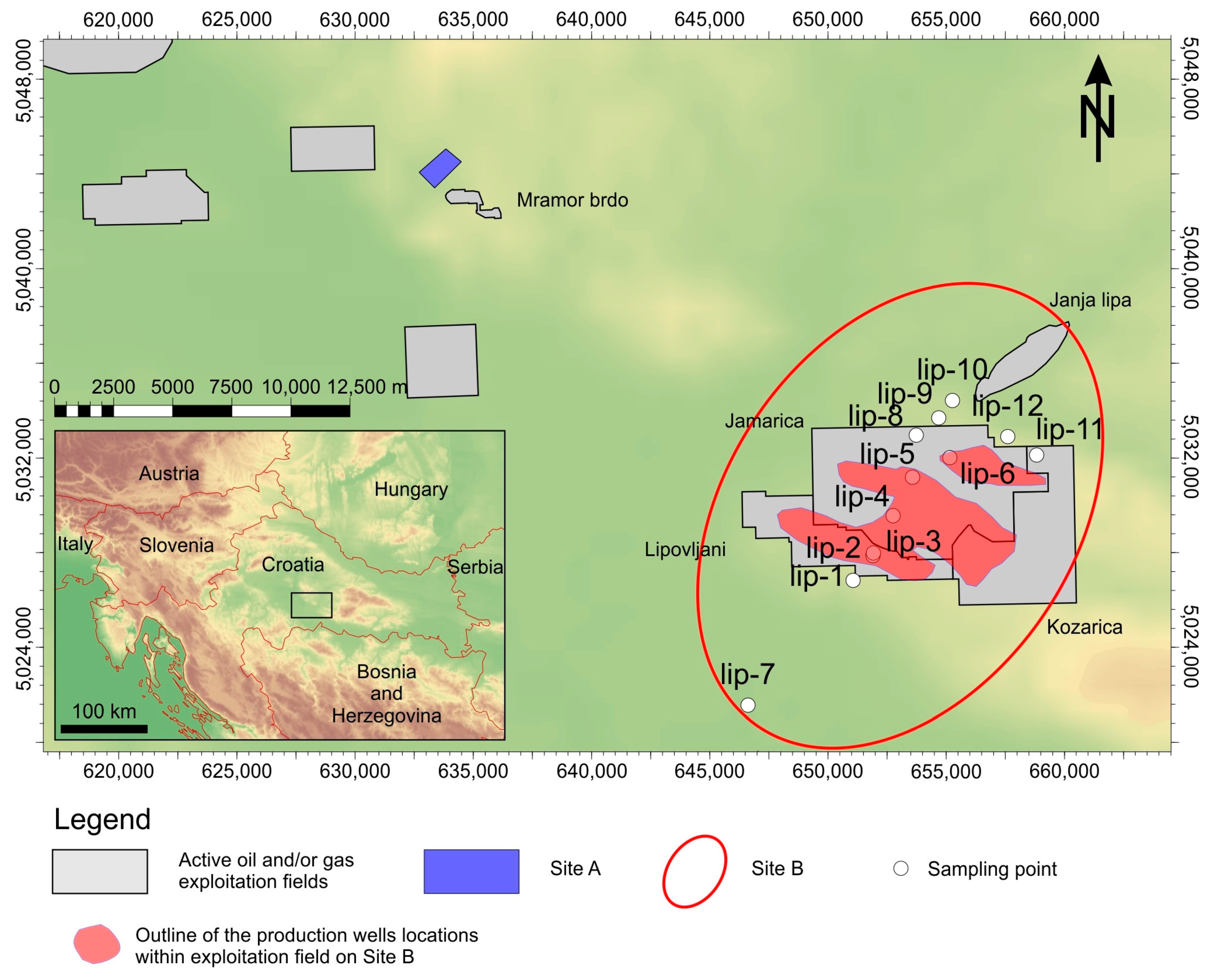
2.1. Geological Settings
2.2. General Petroleum Geology Settings
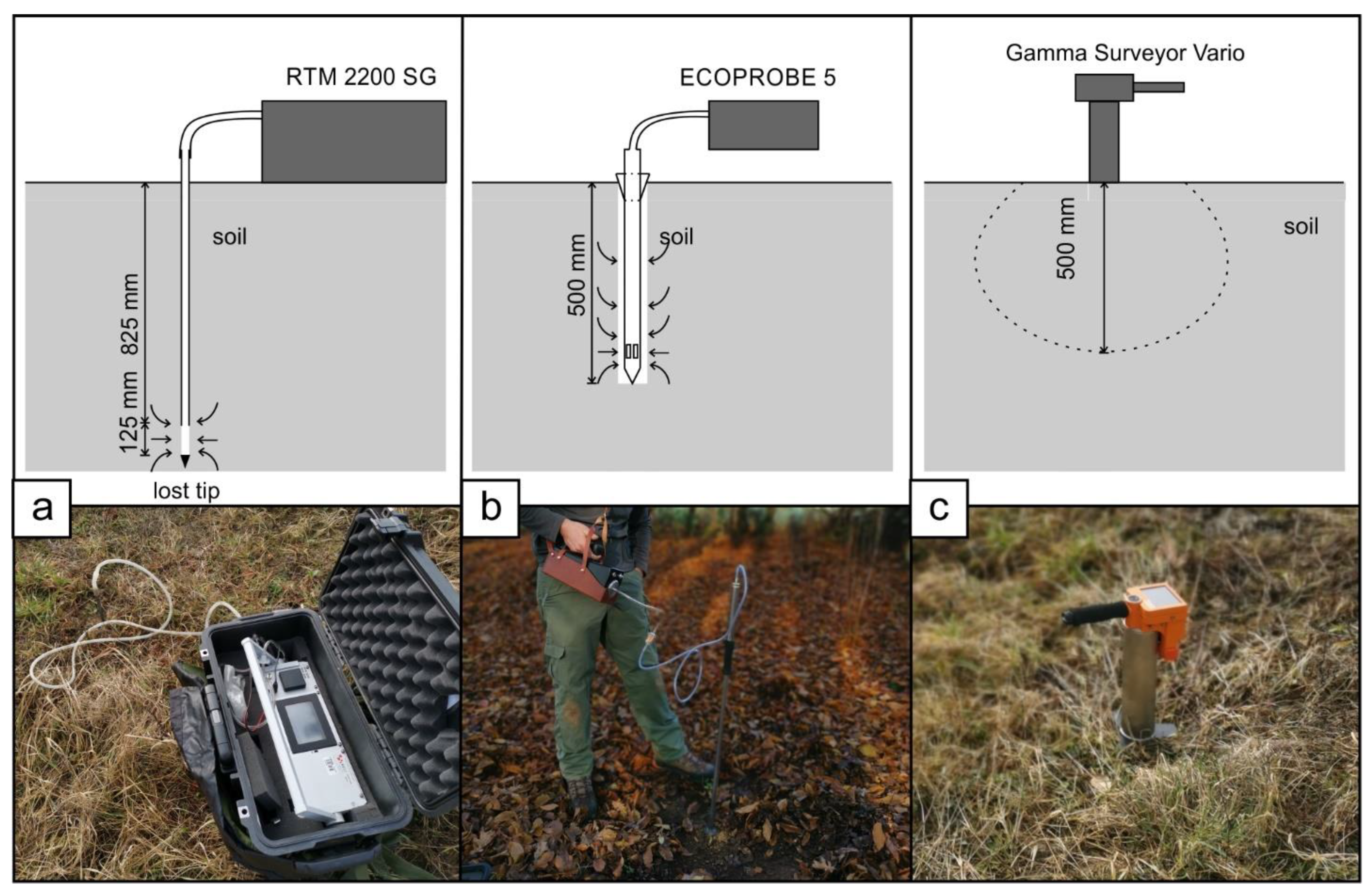
2.3. Radon and Thoron Measurements in Soil Gas
2.4. Carbon Dioxide (CO2), Photo-Ionization Analyzer (PID), Total Petroleum (TP), and Methane (CH4) Concentration Measurements in Soil Gas
2.5. Natural Gamma-Ray Spectrometry
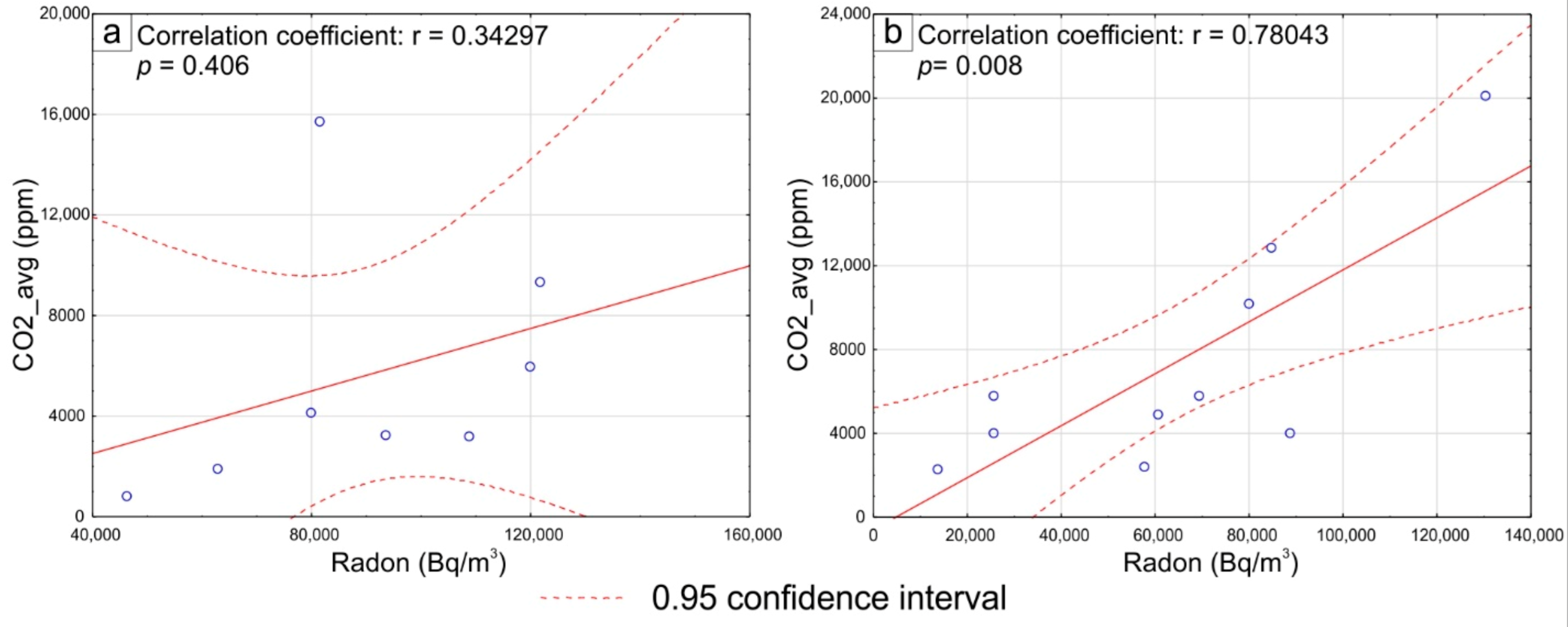
3. Results
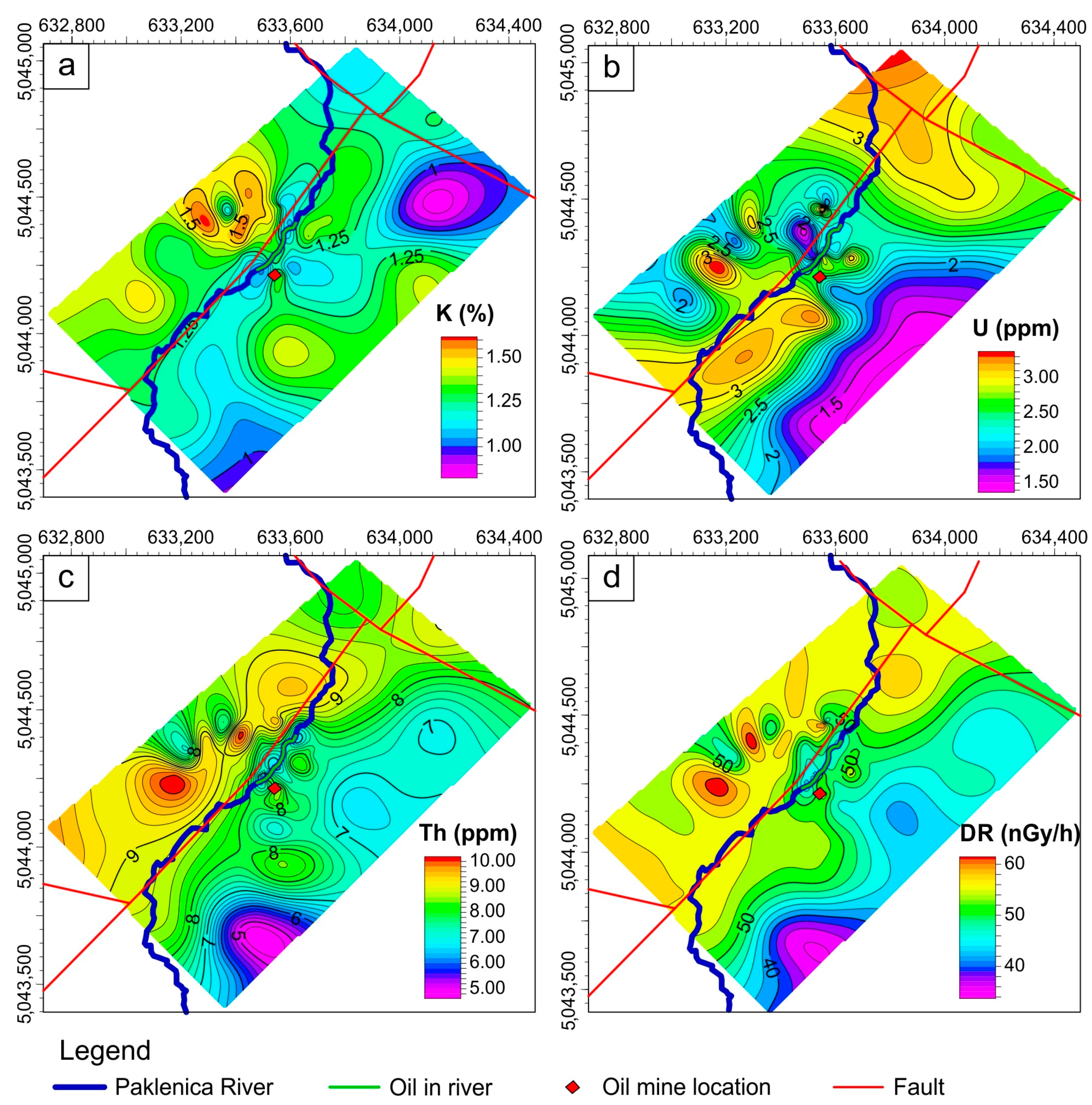
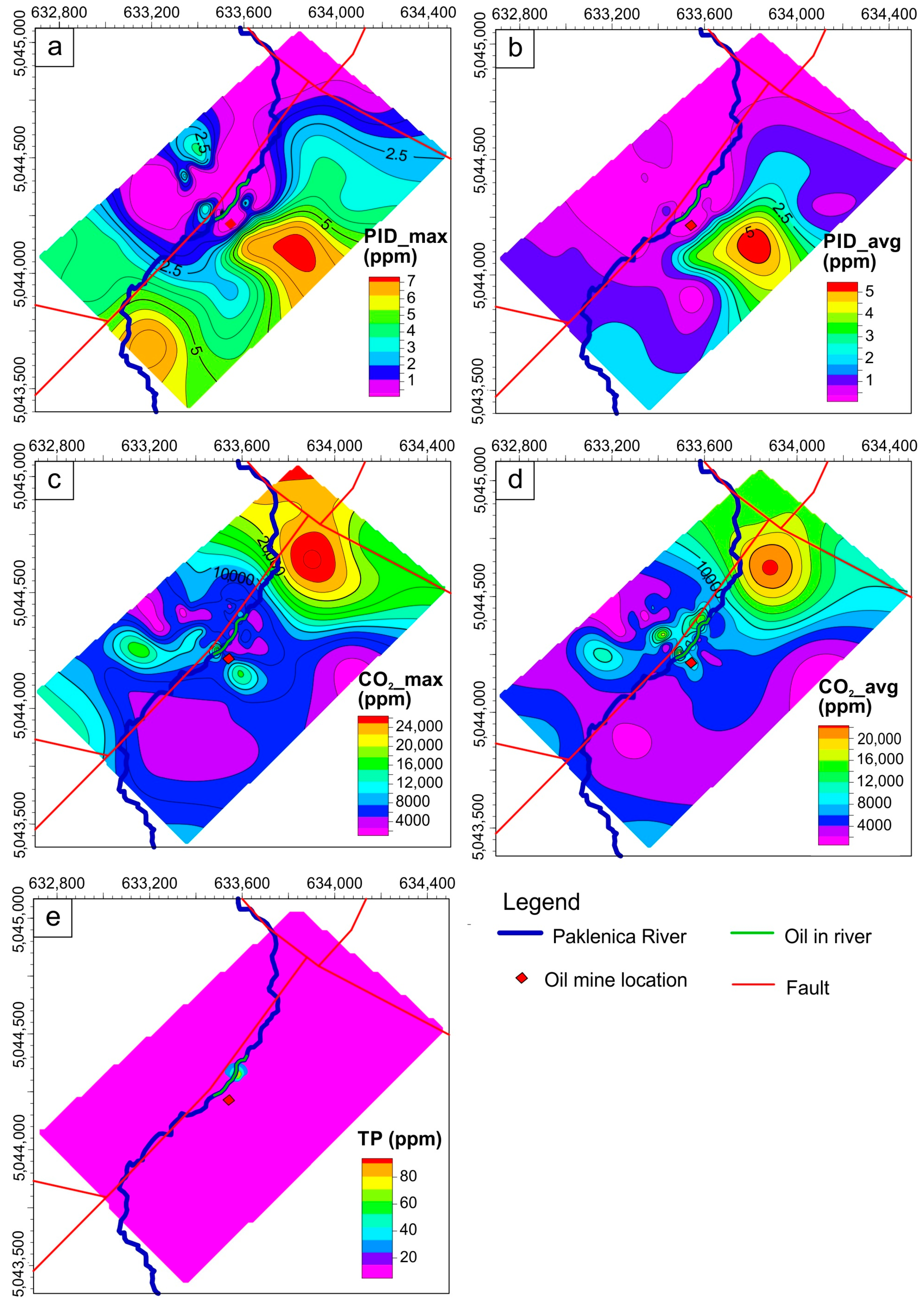
3.1. Site A
3.2. Site B
4. Discussion
5. Conclusions
Author Contributions
Funding
Institutional Review Board Statement
Informed Consent Statement
Acknowledgments
Conflicts of Interest
References
- Chylkova, J.; Machalikova, J.; Obrsalova, I.; Brunclik, T.; Bata, R. Monitoring of Methane and CO2 from Selected Sources in the Environment in the Czech Republic. In Proceedings of the Recent Advances in Environment, Ecosystems and Development, Canary Islands, Spain, 14–16 December 2009; pp. 96–103. [Google Scholar]
- Hendel, J. Occurrence of Microbial and Thermogenic Gases in Post-Mining Areas. In Proceedings of the 17th International Multidisciplinary Scientific GeoConference SGEM2017, Energy and Clean Technologies, Albena, Bulgaria, 29 June–5 July 2017. [Google Scholar]
- Cinelli, G.; Tositti, L.; Capaccioni, B.; Brattich, E.; Mostacci, D. Soil gas radon assessment and development of a radon risk map in Bolsena, Central Italy. Environ. Geochem. Health 2015, 37, 305–319. [Google Scholar] [CrossRef] [Green Version]
- Tokonami, S. Characteristics of Thoron (220Rn) and Its Progeny in the Indoor Environment. Int. J. Environ. Res. Public Health 2020, 17, 8769. [Google Scholar] [CrossRef] [PubMed]
- Sugisaki, R.; Ido, M.; Takeda, H.; Isobe, Y.; Hayashi, Y.; Nakamura, N.; Satake, H.; Mizutani, Y. Origin of Hydrogen and Carbon Dioxide in Fault Gases and Its Relation to Fault Activity. J. Geol. 1983, 91, 239–258. [Google Scholar] [CrossRef]
- Partington, J.R. Discovery of Radon. Nat. Cell Biol. 1957, 179, 912. [Google Scholar] [CrossRef]
- Füst, A.; Geiger, J. Monitoring planning and evaluation using geostatistics, I.Geostatistical support for verification sampling based on professional opinion. Földtani Közlöny 2010, 140, 303–312. [Google Scholar]
- UNSCEAR. Sources and Effects of Ionizing Radiation, Volume I: Sources; United Nations: New York, NY, USA, 2000. [Google Scholar]
- Jönsson, G. Radon gas—Where from and what to do? Radiat. Meas. 1995, 25, 537–546. [Google Scholar] [CrossRef]
- Kristiansson, K.; Malmqvist, L. Evidence for nondiffusive transport of 86Rn in the ground and a new physical model for the transport. Geophysics 1982, 47, 1444–1452. [Google Scholar] [CrossRef]
- Khilyuk, L.F.; Chilingar, G.V.; Robertson, J.O.; Endres, B. Surface Soil-Gas Surveys. In Gas Migration; Elsevier BV: Amsterdam, The Netherlands, 2000. [Google Scholar]
- Dyck, W.; Jonasson, I. Chapter 11 Radon. In Drainage Geochemistry; Elsevier BV: Amsterdam, The Netherlands, 2000; Volume 7, pp. 353–394. [Google Scholar]
- Aubert, M.; Baubron, J.-C. Identification of a hidden thermal fissure in a volcanic terrain using a combination of hydrothermal convection indicators and soil-atmosphere analysis. J. Volcanol. Geotherm. Res. 1988, 35, 217–225. [Google Scholar] [CrossRef]
- Neri, M.; Giammanco, S.; Leonardi, A. Preliminary Indoor Radon Measurements Near Faults Crossing Urban Areas of Mt. Etna Volcano (Italy). Front. Public Health 2019, 7, 7. [Google Scholar] [CrossRef] [Green Version]
- Palacios, D.; Fusella, E.; Avila, Y.; Salas, J.; Teixeira, D.; Fernandez, G.; Salas, A.; Sajo-Bohus, L.; Greaves, E.; Barros, H.; et al. Radon measurements over a natural-gas contaminated aquifer. Radiat. Meas. 2013, 50, 116–120. [Google Scholar] [CrossRef]
- Szabó, K.Z.; Jordan, G.; Horváth, Á.; Szabó, C. Mapping the geogenic radon potential: Methodology and spatial analysis for central Hungary. J. Environ. Radioact. 2014, 129, 107–120. [Google Scholar] [CrossRef] [PubMed]
- Thu, H.N.P.; Van Thang, N.; Hao, L.C. The effects of some soil characteristics on radon emanation and diffusion. J. Environ. Radioact. 2020, 216, 106189. [Google Scholar] [CrossRef]
- Yang, J.; Busen, H.; Scherb, H.; Hürkamp, K.; Guo, Q.; Tschiersch, J. Modeling of radon exhalation from soil influenced by environmental parameters. Sci. Total. Environ. 2019, 656, 1304–1311. [Google Scholar] [CrossRef] [PubMed]
- Fernández, C.S.; Poncela, L.Q.; Villar, A.F.; Merino, I.F.; Gutierrez-Villanueva, J.; González, S.C.; López, L.Q.; Fernández, E.; Tejerina, J.R.; Matarranz, J.M.; et al. Spanish experience on the design of radon surveys based on the use of geogenic information. J. Environ. Radioact. 2017, 166, 390–397. [Google Scholar] [CrossRef] [PubMed] [Green Version]
- Melintescu, A.; Chambers, S.; Crawford, J.; Williams, A.; Zorila, B.; Galeriu, D. Radon-222 related influence on ambient gamma dose. J. Environ. Radioact. 2018, 189, 67–78. [Google Scholar] [CrossRef]
- Cinelli, G.; Tollefsen, T.; Bossew, P.; Gruber, V.; Bogucarskis, K.; De Felice, L.; De Cort, M. Digital version of the European Atlas of natural radiation. J. Environ. Radioact. 2019, 196, 240–252. [Google Scholar] [CrossRef]
- García-Talavera, M.; García-Pérez, A.; Rey, C.; Ramos, L. Mapping radon-prone areas using γ-radiation dose rate and geological information Related content Mapping radon-prone areas using γ-radiation dose rate and geological information. J. Radiol. Prot. 2013, 33, 605–620. [Google Scholar] [CrossRef] [Green Version]
- Tchorz-Trzeciakiewicz, D.; Rysiukiewicz, M. Ambient gamma dose rate as an indicator of geogenic radon potential. Sci. Total. Environ. 2021, 755, 142771. [Google Scholar] [CrossRef]
- Hentati, O.; Lachhab, R.; Ayadi, M.; Ksibi, M. Toxicity assessment for petroleum-contaminated soil using terrestrial invertebrates and plant bioassays. Environ. Monit. Assess. 2012, 185, 2989–2998. [Google Scholar] [CrossRef]
- Péter, O.; Abioye, O.P. Biological Remediation of Hydrocarbon and Heavy Metals Contaminated Soil. In Soil Contamination; IntechOpen: London, UK, 2011. [Google Scholar]
- Das, N.; Chandran, P. Microbial Degradation of Petroleum Hydrocarbon Contaminants: An Overview. Biotechnol. Res. Int. 2011, 2011, 1–13. [Google Scholar] [CrossRef] [Green Version]
- Eea Eudem—Copernicus Land Monitoring Service. Available online: https://land.copernicus.eu/homepage-content/eu_dem.png/view (accessed on 10 August 2020).
- Gretić, Z.; Bobić, D. From Oil Outcrops to Oil Fields [Od Paklina do Naftnih Polja]; INA d.d.: Zagreb, Croatia, 2002. [Google Scholar]
- Velić, J.; Krasić, D.; Kovačević, I. Exploitation, reserves and transport of natural gas in the Republic of Croatia. Tech. Vjesn. Gaz. 2012, 13, 633–641. [Google Scholar]
- Pavelić, D.; Kovačić, M. Sedimentology and stratigraphy of the Neogene rift-type North Croatian Basin (Pannonian Basin System, Croatia): A review. Mar. Pet. Geol. 2018, 91, 455–469. [Google Scholar] [CrossRef]
- Balen, D.; Petrinec, Z. Contrasting tourmaline types from peraluminous granites: A case study from Moslavačka Gora (Croatia). Miner. Pet. 2011, 102, 117–134. [Google Scholar] [CrossRef]
- Saftić, B.; Velić, J.; Sztanó, O.; Juhász, G.; Ivković, Ž. Tertiary subsurface facies, source rocks and hydrocarbon reservoirs in the SW part of the Pannonian Basin (Northern Croatia and south-western Hungary). Geol. Croat. 2003, 56, 101–122. [Google Scholar]
- Lučić, D.; Saftić, B.; Krizmanić, K.; Prelogović, E.; Britvić, V.; Mesić, I.; Tadej, J. The Neogene evolution and hydrocarbon potential of the Pannonian Basin in Croatia. Mar. Pet. Geol. 2001, 18, 133–147. [Google Scholar] [CrossRef]
- MIitchum, R.M.J. Seismic Stratigraphy and Global Changes of Sea Level, Part 11: Glossary of Terms used in Seismic Stratigraphy. In Seismic Stratigraphy–Applications to Hydrocarbon Exploration; Payton, U., Ed.; AAPG: Tulsa, OK, USA, 1977; pp. 205–212. [Google Scholar]
- Ćorić, S.; Pavelić, D.; Rögl, F.; Mandić, O.; Vrabac, S.; Avanić, R.; Jerković, L.; Vranjković, A. Revised Middle Miocene datum for initial marine flooding of North Croatian Basins (Pannonian Basin System, Central Paratethys). Geol. Croat. 2009, 62, 31–43. [Google Scholar] [CrossRef]
- Kováč, M.; Andreyeva-Grigorovich, A.; Bajraktarević, Z.; Brzobohatý, R.; Filipescu, S.; Fodor, L.; Harzhauser, M.; Nagymarosy, A.; Oszczypko, N.; Pavelić, D.; et al. Badenian evolution of the Central Paratethys Sea: Paleogeography, climate and eustatic sea-level changes. Geol. Carpathica 2007, 58, 579–606. [Google Scholar]
- Piller, W.E.; Harzhauser, M.; Mandic, O. Miocene Central Paratethys stratigraphy—Current status and future directions. Stratigraphy 2007, 4, 151–168. [Google Scholar]
- Pavelic, D. Cyclicity in the evolution of the neogene north Croatian basin (Pannonian Basin System). In Developments in Sedimentology; Elsevier BV: Amsterdam, The Netherlands, 2005; pp. 273–283. [Google Scholar]
- Malvić, T.; Cvetković, M. Lithostratigraphic units in the Drava Depression (Croatian and Hungarian parts)—A correlation. Nafta 2013, 63, 27–33. [Google Scholar]
- Horváth, F.; Bada, G.; Szafián, P.; Tari, G.; Ádám, A.; Cloetingh, S. Formation and deformation of the Pannonian Basin: Constraints from observational data. Geol. Soc. Lond. Mem. 2006, 32, 191–206. [Google Scholar] [CrossRef]
- Sebe, K.; Kovačić, M.; Magyar, I.; Krizmanić, K.; Špelić, M.; Bigunac, D.; Sütő-Szentai, M.; Kovács, Á.; Szuromi-Korecz, A.; Bakrač, K.; et al. Correlation of upper Miocene–Pliocene Lake Pannon deposits across the Drava Basin, Croatia and Hungary. Geol. Croat. 2020, 73, 177–195. [Google Scholar] [CrossRef]
- Geary, D.; Magyar, I.; Muller, P. Ancient Lake Pannon and its endemic molluscan fauna (Central Europe; mio-pliocene). Adv. Ecol. Res. 2000, 31, 463–482. [Google Scholar] [CrossRef]
- Velic, J.; Malvic, T.; Cvetkovic, M.; Vrbanac, B. Characteristics of hydrocarbon fields in the Croation part of the Pannonian basin. Oil Gas Eur. Mag. 2010, 36, 146–147. [Google Scholar]
- Velić, J. Geologija Nafte [Petroleum Geology]; University of Zagreb, Faculty of Mining, Geology and Petroleum Engineering: Zagreb, Croatia, 2007. [Google Scholar]
- Brkić, Ž. The relationship of the geological framework to the Quaternary aquifer system in the Sava River valley (Croatia). Geol. Croat. 2017, 70, 201–213. [Google Scholar] [CrossRef]
- Cvetković, M. Possibilities for Well Log Correlation using Standard Deviation Trends in Neogene-Quaternary Sediments, Sava Depression, Pannonian Basin. Geol. Croat. 2017, 70, 79–85. [Google Scholar] [CrossRef]
- Velić, J.; Malvić, T.; Cvetković, M.; Vrbanac, B. Reservoir geology, hydrocarbon reserves and production in the Croatian part of the pannonian Basin System. Geol. Croat. 2012, 65, 91–101. [Google Scholar] [CrossRef]
- Etiope, G.; Lombardi, S. Evidence for radon transport by carrier gas through faulted clays in Italy. J. Radioanal. Nucl. Chem. 1995, 193, 291–300. [Google Scholar] [CrossRef]
- Durrance, E.M.; Gregory, R.G. Helium and radon transport mechanisms in hydrothermal circulation systems of Southwest England. In Geochemistry of Gaseous Elements and Compounds; Theophrastus Pub. S.A.: Athens, Greece, 1990; pp. 337–352. [Google Scholar]
- Hanrahan, G. Key Concepts in Environmental Chemistry; Elsevier BV: Amsterdam, The Netherlands, 2012. [Google Scholar]
- Schwela, D.; Kotzias, D. Pollution, Air Indoor. In Encyclopedia of Toxicology; Elsevier: Amsterdam, The Netherlands, 2005; pp. 475–489. [Google Scholar]
- Latyshova, M.G.; D’Yakonova, T.F. Reliability evaluation for geological and geophysical information in calculating oil and gas reserves. Int. Geol. Rev. 1981, 23, 977–982. [Google Scholar] [CrossRef]
- Schumacher, D. Hydrocarbon-Induced Alteration of Soils and Sediments. In Hydrocarbon Migration and Its Near-Surface Expression; Schumacher, D., Abrams, M.A., Eds.; American Association of Petroleum Geologists: Vancouver, BC, Canada, 1996; pp. 71–89. ISBN 9781629810812. [Google Scholar]
- Heemstra, R.; Ray, R.; Wesson, T.; Abrams, J.; Moore, G. Critical Laboratory and Field Evaluation of Selected Surface Prospecting Techniques for Locating Oil and Natural Gas; Department of Energy, Artlesville Energy Technology Centre: Bartlesville, OK, USA, 1979. [Google Scholar]
- Crnko, J. Geological Map of Croatia–Kutina; Croatian Geological Survey: Zagreb, Croatia, 2014. [Google Scholar]
- Neznal, M. Permeability as an important parameter for radon risk classification of foundation soils. Ann. Geophys. 2005, 48, 175–180. [Google Scholar]
- Barnet, I.; Pacherova, P.; Neznal, M. Radon in Geological Environment-Czech Experience; Czech Geological Survey: Prague, Czech Republic, 2008; ISBN 978-80-7075-707-9. [Google Scholar]
- Barbur, V.A.; Montgomery, D.C.; Peck, E.A. Introduction to Linear Regression Analysis. J. R. Stat. Soc. Ser. D 1994, 43, 339. [Google Scholar] [CrossRef]
- Kiefer, R.H.; Amey, M.R.G. Concentrations and controls of soil carbon dioxide in sandy soil in the North Carolina coastal plain. Catena 1992, 19, 539–559. [Google Scholar] [CrossRef]
- Enoch, H.; Dasberg, S. The occurrence of high CO2, concentrations in soil air. Geoderma 1971, 6, 17–21. [Google Scholar] [CrossRef]
- Gregory, R.; Durrance, E. Helium, carbon dioxide and oxygen soil gases: Small-scale variations over fractured ground. J. Geochem. Explor. 1985, 24, 29–49. [Google Scholar] [CrossRef]
- Wilkening, M. Radon transport processes below the Earth’s surface. In The Natural Radiation Environment, III; US Department of Energy: Washington, DC, USA, 1980; pp. 90–104. [Google Scholar]
- Ilie, A.M.C.; Vaccaro, C. Atmospheric and Soil Methane Concentrations Integrating a New Gas Detection Technology. In Proceedings of the 1st International Electronic Conference on Applied Sciences, Tokyo, Japan, 10–30 November 2020. [Google Scholar]
- Matolín, M.; Stráník, Z. Radioactivity of sedimentary rocks over the Ždánice hydrocarbon field. Geophys. J. Int. 2006, 167, 1491–1500. [Google Scholar] [CrossRef] [Green Version]
- Fernández, D.P.; Fusella, E.; Avila, Y.; Salas, J.; Teixeira, D.; Fernández, G.; Sajo-Bohus, L.; Greaves, E.; Barros, H.; Bolívar, M.; et al. Soil gas radon and thoron measurements in some Venezuelan oilfields. J. Radioanal. Nucl. Chem. 2015, 307, 801–810. [Google Scholar] [CrossRef]
- Kovačević, M. Petrological, Petrophysical and Geochemical Features of the Miocene Deposits of Požega Valley. Master’ Thesis, University of Zagreb, Zagreb, Croatia, 2017. [Google Scholar]


| Sample ID | Radon (Bq/m3) | Thoron (Bq/m3) |
|---|---|---|
| lip-1 | 56,465 (+/− 2195) | 24,277 (+/− 1439) |
| lip-2 | 102,174 (+/− 2953) | 22,482 (+/− 1385) |
| lip-3 | 86,665 (+/− 2720) | 24,456 (+/− 1444) |
| lip-4 | 112,763 (+/− 3102) | 27,940 (+/− 1544) |
| lip-5 | 105,254 (+/− 2997 | 28,137 (+/− 1549) |
| lip-6 | 119,781 (+/− 3197) | 20,180 (+/− 1312) |
| lip-7 | 79,621 (+/− 2607) | 17,125 (+/− 1209) |
| lip-8 | 94,390 (+/− 2838) | 32,217 (+/− 1658) |
| lip-9 | 73,533 (+/− 2505) | 16,695 (+/− 1193) |
| lip-10 | 81,936 (+/− 2644) | 34,026 (+/− 1704) |
| lip-11 | 107,165 (+/− 3024) | 19,362 (+/− 1285) |
| lip-12 | 82,325 (+/− 2651) | 34,521 (+/− 1716) |
| Sample ID | CO2_max (ppm) | CO2_avg (ppm) | PID_max (ppm) | PID_avg (ppm) | TP (ppm) | CH4 (ppm) |
|---|---|---|---|---|---|---|
| lip-1 | 4280 | 2629 | 4.69 | 1.82 | - | - |
| lip-2 | 4720 | 3064 | 44.81 | 28.02 | 135 | - |
| lip-3 | 4063 | 3414 | 4.36 | 1.94 | 99.3 | - |
| lip-4 | 4676 | 3903 | 1.93 | 0.97 | 430 | - |
| lip-5 | 5519 | 3634 | 3.14 | 1.48 | 551.7 | - |
| lip-6 | 18,892 | 9574 | 1.24 | 0.16 | 2439 | 1846 |
| lip-7 | 16,251 | 11,486 | - | - | - | - |
| lip-8 | 3145 | 1834 | 1.46 | 0.13 | - | - |
| lip-9 | 3325 | 2217 | 2.93 | 0.84 | - | - |
| lip-10 | 6115 | 5892 | 2.83 | 2.34 | - | - |
| lip-11 | 7022 | 4154 | 2.98 | 0.64 | - | - |
| lip-12 | 6819 | 4724 | 1.98 | 0.83 | - | - |
Publisher’s Note: MDPI stays neutral with regard to jurisdictional claims in published maps and institutional affiliations. |
© 2021 by the authors. Licensee MDPI, Basel, Switzerland. This article is an open access article distributed under the terms and conditions of the Creative Commons Attribution (CC BY) license (https://creativecommons.org/licenses/by/4.0/).
Share and Cite
Cvetković, M.; Kapuralić, J.; Pejić, M.; Kolenković Močilac, I.; Rukavina, D.; Smirčić, D.; Kamenski, A.; Matoš, B.; Špelić, M. Soil Gas Measurements of Radon, CO2 and Hydrocarbon Concentrations as Indicators of Subsurface Hydrocarbon Accumulation and Hydrocarbon Seepage. Sustainability 2021, 13, 3840. https://0-doi-org.brum.beds.ac.uk/10.3390/su13073840
Cvetković M, Kapuralić J, Pejić M, Kolenković Močilac I, Rukavina D, Smirčić D, Kamenski A, Matoš B, Špelić M. Soil Gas Measurements of Radon, CO2 and Hydrocarbon Concentrations as Indicators of Subsurface Hydrocarbon Accumulation and Hydrocarbon Seepage. Sustainability. 2021; 13(7):3840. https://0-doi-org.brum.beds.ac.uk/10.3390/su13073840
Chicago/Turabian StyleCvetković, Marko, Josipa Kapuralić, Marija Pejić, Iva Kolenković Močilac, David Rukavina, Duje Smirčić, Ana Kamenski, Bojan Matoš, and Marko Špelić. 2021. "Soil Gas Measurements of Radon, CO2 and Hydrocarbon Concentrations as Indicators of Subsurface Hydrocarbon Accumulation and Hydrocarbon Seepage" Sustainability 13, no. 7: 3840. https://0-doi-org.brum.beds.ac.uk/10.3390/su13073840