1. Introduction
The basic premise of this research is that rural roads are ambivalent elements in cultural landscapes: while they are responsible for territorial functionality and the cohesion of spaces at the local/landscape scale, their presence leads to fragmentation and internal division of the landscape. Our main objective is to study the role of minor rural road network from the perspective of cultural landscapes and as an expression of the processes that fragment and integrate them.
For decades, the concept of landscape has been constructed from an integrated perspective, implementing structural and functional approaches. The European Landscape Convention (ELC) helped to consolidate this approach, introducing the social dimension as a relevant aspect, bringing importance to perception and human intervention in landscapes [
1] and, consequently, emphasising the need for landscape planning and management [
2]. In Europe, the landscape is characterised by the strong influence of the interaction between natural conditions and the agricultural use of the territory [
3], forming for the most part a mosaic of cultural landscapes, a combination of natural and social aspects.
The road network is strongly interdependent with the rest of land uses of landscapes, since its essential function is to provide the best possible connectivity between places and activities, but at the same time it generates impacts in the ecological sphere, essentially fragmenting landscape units. The integrity and continuity of the units in which the landscape is arranged and differentiated is considered an essential factor in the balance and sustainability of such units [
4], which is why fragmentation is one of the impacts in landscape units usually related to the road network, reducing them to smaller pieces and generating discontinuity in their constituent elements [
5,
6,
7]. Therefore, landscape fragmentation is a process defined by the breaking of habitats into smaller subunits, reducing the spatial continuity of their elements [
8,
9].
The aim of this article is to analyse the role of minor rural roads in the structure of agrarian cultural landscapes and to assess fragmentation as part of its character. By their nature, roads are at the same time agents of integration and fragmentation, while facilitating the connection between land uses and contributing to an increase in the internal division of landscapes. However, the dynamics in the European rural matrix open an interesting debate on the character of this dichotomous process between integration and fragmentation, which coexists at the same time with the duality between the fragmentation and defragmentation of cultural landscapes [
10]. We focus our analysis on the minor rural network, composed as the sum of rural roads, livestock routes, touristic trails and footpaths. This network is important at a local scale, but also has dichotomic role on landscape function and fragmentation. We differentiate major infrastructures from minor rural network. The former are built following technical and legal prescriptions and use materials that affects wildlife crossing (fenced areas) and soil permeability (asphalt, concrete, etc.). On the contrary, the minor rural network is, in its majority, a network without an artificial coverage that usually contributes to absorption and permeability.
At the level we propose to focus on, scale plays a major role. The scale of work on the territory has traditionally been determined by the type of data available or the technical requirements for managing large volumes of data. At present; however, scale and its constraints are not limiting for landscape or other geographical studies, although any type of research must be rational in the way it handles information [
11]. We aim to remain as close as possible to the actions of the actors involved in landscape fragmentation. It is at these scales that we can mostly avoid the errors hidden by aggregation. We have therefore decided to use the Land Parcel Identification System (LPIS,
SIGPAC (
https://www.mapa.gob.es/es/agricultura/temas/sistema-de-informacion-geografica-de-parcelas-agricolas-sigpac-/default.aspx, (accessed on 22 April 2021)) developed for Common Agricultural Policy (CAP) management [
12].
We develop our objectives by focusing on two specific aspects developed by two Research Questions (RQ,
Table 1): firstly (RQ1), we will try to understand the importance of the minor rural road network together with other elements in the fragmentation of cultural landscapes. The design, function and use of infrastructure have a substantive effect on both the structure and character of landscapes and are factors in transformation and/or abandonment [
5]. As a result, we introduce the methodological factor linked to the most appropriate fragmentation indicators to assess the impact of infrastructure elements on the landscape.
The second point of interest (RQ2) is the use of large-scale land use databases, in our case the LPIS, as a measure of landscape fragmentation. Thus, this instrument at the European level could have a new use in landscape and land management policies. In this paper, we will explore the opportunities of applying different fragmentation indicators and compare their usefulness. The territory where we are implementing this idea is the province of Ciudad Real (Spain, NUTS 3 ES422).
The text unfolds as follows. After this introduction,
Section 2 develops the theoretical framework that contextualises the study, starting from the relationship between the European rural matrix, cultural landscapes and landscape fragmentation and the role of rural roads in this process.
Section 3 presents the case study to which we apply the proposed analysis and from which we obtain the results set out in
Section 4, which are discussed in
Section 5. We finish with some conclusions and avenues for future research in the sixth and final section.
2. Theoretical Approach: Rural Matrix, Landscapes, and Fragmentation Due to Rural Roads
The consideration of different ecological units within a landscape introduces a multifunctional perspective and the capacity of a landscape to concurrently offer multiple spaces [
13] which, from the perspective of the cultural landscape, complements structural approaches and broadens the range of the concept of landscape. Cultural landscapes as socio-ecological systems combine anthropic use with natural dynamics. Different land covers, natural or agricultural, give rise to different habitat conditions and biophysical relationships that are organised in patterns and interact with one another [
14,
15]. Europe’s spatial structure is strongly determined by human presence, and current land uses are heavily influenced by society, with an evolution characterised by periods of widespread deforestation and ploughing alongside periods of agricultural abandonment [
16], all subject to the social dynamics of the territory. Consequently, cultural landscapes in Europe are essentially shaped by the agricultural variable, which is responsible for the identity of large areas of the continent and for biodiversity itself [
17] (pp. 211–212).
Consequently, under this approach, in Europe we can speak of a predominance of rural landscapes, with an essentially agrarian matrix containing different configurations related to the natural characteristics (morphology, soil, climate and vegetation) and to the cultural character, embodied in the structure of land use and changes in land use. If both elements (natural and cultural) are sometimes expressed in a dichotomous or excluding way, it is correct to classify the landscape within a gradient between extremes, from the maximum density of natural factors to the artificialisation of densely urbanised spaces [
18]. From this perspective, most cases will always be transitional or mixed landscapes, with contributions from all elements. In these landscapes the combination of factors is particularly relevant to understanding their structure and processes.
There is a notable body of studies that focus on the structural aspects of landscape fragmentation as a process that undermines the continuity of ecosystems and their biodiversity, to the extent that the European Environmental Agency (EEA) proposes incorporating fragmentation parameters into regional and transport planning processes [
9]. Although some empirical work has found evidence that landscapes with a greater number of parts actually offer more opportunities for different species, increasing biodiversity [
19,
20], the interpretation of landscape fragmentation is usually negative, and it is human action that is essentially responsible for such fragmentation through the artificialisation of land, either by urbanisation [
21] or transport infrastructure [
22] in a degradation process identified as one of the most evident threats to landscape conservation on the continent [
9].
Many studies make proposals that focus on the structural aspects of fragmentation; essentially the number, size and geometry of the different patches that make up a landscape unit [
17,
22,
23,
24]. This approach focuses on the impact of fragmentation from an ecological point of view and, in a way, assimilates three main types of elements under the concept of a mosaic: fragments, corridors and the landscape matrix [
25], which relate to nature conservation [
26]. The most common causes of these fragmentation processes are of human origin, creating an obstacle to the internal connectivity of natural habitats. The key drivers of this fragmentation are transport infrastructure, urban development, and the agricultural system [
27].
In this sense, several studies point out that environments characterised by agricultural use also experience the negative impact of fragmentation, in an interpretation of the integration-segregation of uses [
13] and the dispersion of populations that underlies current rural problems [
21]. The integrity of rural cultural landscapes, which bring together both natural and social values, is also threatened by fragmentation processes, which usually break up traditional territorial patterns in favour of vectors of change that may come from new functions or the productive intensification of an activity [
10] (p. 138). In these territories, the areas most affected by fragmentation are those linked to agricultural uses and farmland [
28], but most studies work on a low, practically continental scale, and do not allow us to appreciate the differences between agricultural uses that can be found in landscapes with a strong agricultural component.
Recent decades have seen major changes in the European rural matrix, essentially linked to agricultural and forestry practices, with irreversible impacts in many cases. Two opposing trends can be observed in the agricultural context: on the one hand, the intensification of production that is gradually replacing the traditional road network with a larger-scale network that can be assimilated to hyperconnectivity; on the other hand, a trend towards land abandonment, related both to ecological factors and to soil productivity and its management systems [
29] and the stagnation of more traditional activities [
17], which does not necessarily lead to renaturalisation of the territory [
30].
At the same time, fragmentation leads to losses in landscape connectivity [
8]. Other territorial factors undergo the reverse process: they increase their connectivity, their interaction potential, they defragment [
31] (p. 96). Indeed, what can be understood as a process of landscape degeneration is a process of land use change, whereby some uses increase its connectivity at the expense of others, which reduce it [
17]. This includes both the natural matrix of the landscape and the cultural elements that make up the traditional European agricultural landscape.
Thus, transport infrastructure elements have the essential objective of guaranteeing the connectivity and integration of territories and are the basis on which to build the development capacity of territories [
32].
Rural roads are communication routes with a local and specific functional scale, which can be analysed through large-scale databases. Rural roads are particularly significant structures for understanding the specific interrelationship between land uses. The role of rural roads is essential in the configuration and shaping of rural landscapes, from a traditional perspective as heritage elements and as agents of change towards new landscape configurations.
In landscapes with a strong agricultural component, roads show a multifunctionality that is also related to the character of the traditional landscape. They serve as a connection between agricultural uses and the different functions within them, as distributors and connectors of a local character [
5], and they are fundamental to the stability and sustainability of this type of landscape. At the same time, they perform ecological functions, such as in landscapes with little natural use, where the roadside can be considered a biological reservoir [
33], forming fragile and vulnerable ecosystems [
34]. Given its functionality, the rural road network is an invariant factor in agricultural landscapes with a notable role in the structure and configuration of the rural matrix.
This process leads to highly specialised areas, in which the productive factor intensifies and modifies the traditional patterns of land exploitation, generating a loss of cultural values [
35]. Faced with this problem of cultural loss, various initiatives have emerged for cultural agricultural landscape management, such as the Baeza Charter on agricultural heritage, which includes the conservation of rural roads [
36].
Under these premises, logic demands broadening the basis of reasoning on the relationship between fragmentation and transport infrastructure, particularly in the case of purely local roads. Increased road density often fragments landscapes and is one of the main causes of fragmentation. This means a loss in ecosystem connectivity, which places the argument in a dichotomous and exclusionary situation: more anthropic connectivity means less environmental/natural connectedness. Such logic reduces the interpretative potential in the context of cultural landscapes, where empirical experience shows us that there are interpretative nuances that can be lost or even misinterpreted when the argument is based on the indicator.
3. Materials and Methods
3.1. Study Case: The Rural Matrix in Ciudad Real (Spain)
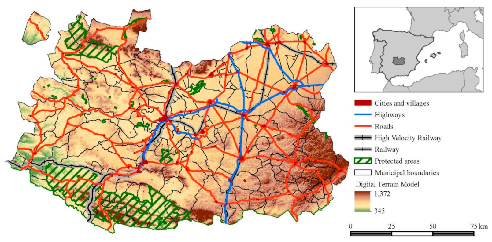
Our study area is the province of Ciudad Real in Spain (NUTS 3 ES422,
Figure 1), in the centre of the Iberian Peninsula. It occupies an area of 19,813 km
2 and includes different geomorphological domains, which will serve as the basis for the formation of different landscapes. The north-eastern area is part of the great plain of La Mancha. Geologically it consists of Tertiary sedimentary materials, which facilitate the formation of a large underground aquifer. Therefore, this is an area dedicated to irrigated crops and vineyards. The south-eastern quarter of the province is known as Campo de Montiel and is dominated by moorland and large expanses of cultivated land over secondary and tertiary geological materials. The dominant agricultural uses of cereals, vineyard, olive, and almond trees are mixed with patches of Mediterranean scrubland. The western part of the province, however, is dominated by mountain landscapes, with gentle hills and wide valleys or corridors over Palaeozoic materials with extensive olive groves and fields of cereal, pastures, and large patches of Mediterranean woodland in the higher areas. This wide diversity of landscapes explains why the province has two national parks (Las Tablas de Daimiel National Park and Cabañeros National Park), two natural parks (Lagunas de Ruidera Natural Park and Alcudia Valley and Sierra Madrona Natural Park) and a proposed geopark dedicated to volcanism (Campo de Calatrava Volcanoes). The potential for tourism is remarkable. For this reason, successful management of the rural landscapes that encompass these protected areas and proper conservation of the network of rural roads are considered strategies for diversification and sustainability in territorial development.
The dynamics of land occupation are highly dependent on historical factors related to the structure of land ownership and demographic evolution. In the province of Ciudad Real, the areas of greatest agricultural interest were settled and ploughed from the 12th century onwards, while mountainous areas or areas far from the towns were reserved in large estates for livestock and forestry use. This has led to great contrasts in land distribution and consequently in the structure of plots and landscapes. On the other hand, as has been the case in much of Europe, since the mid-20th century, rural-urban migration has been more intense in less productive agricultural areas, while in areas with greater agricultural potential and groundwater for irrigation, agricultural transformations have been very intense. Consequently, the province of Ciudad Real has three types of regions or
comarcas: plains, transition areas and hilly areas. The first type of region is characterised by high agricultural specialisation thanks to the exploitation of groundwater [
37], while the others are characterised by land abandonment, lack of productivity and ageing and migration of their population [
38].
3.2. Data Collection and Procedures
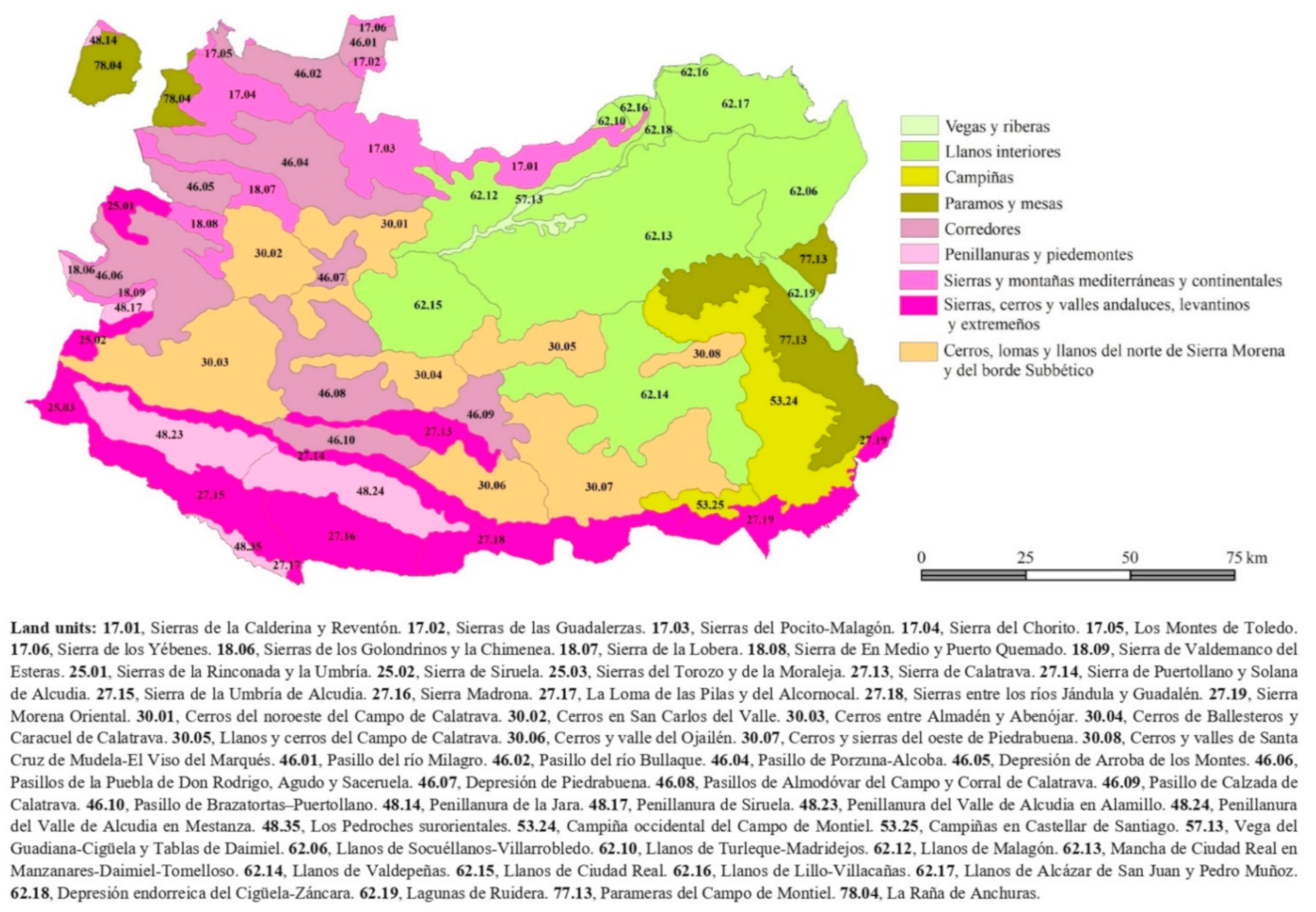
The source of information on landscape units in the province of Ciudad Real will be the Atlas of Spanish Landscapes published by the Ministry of the Environment [
39], which identifies a total of 57 landscape units summarised into 9 landscape associations. Landscape associations, according to the Atlas methodology, are groupings that integrate types that are close in topographic configuration, bioclimatic characteristics, and similarities in their organisational features in land use. A map with landscape associations and units can be consulted on
Appendix A,
Figure A1.
The source of information for analysing the fragmentation of landscape units is the LPIS database for the province of Ciudad Real for the year 2020. This information allows us to explore landscape unit characteristics at a very detailed scale, as it captures the infrastructure elements as surface and non-linear entities, and we can classify the uses according to several criteria that are summarised in the concept of coverage, i.e., by the biophysical properties and relationships of the use with respect to the ecological environment and human activity, such as vegetation structure, use of water for irrigation, technology and labour [
15,
40].
The LPIS database divides the territory of the province of Ciudad Real into more than 1.3 million enclosures or parcels where land ownership is another attribute that characterises the shape of the enclosures. Therefore, before starting the calculation of fragmentation indicators, we need to manage this geodatabase to reach a map of homogeneous land use patches for each landscape unit. This work was carried out using ArcMap 10.3 software.
A first step is to add to each LPIS area its Landscape Unit code, which will be one of the criteria for the generalisation or dissolution of polygons. The second step focuses on identifying and classifying the polygons of the different communications infrastructure elements. In the LPIS all such enclosures are grouped under the code “CA” (communication roads). With the help of the digital National Topographic Map at a scale of 1:25,000, we differentiated these road polygons into different categories: motorways, railways, main roads, secondary roads, and what we called the minor rural network, including rural roads, livestock routes, touristic trails and footpaths. Then we added a level of occlusion characterising the limitation of movement or traffic according to each category (
Table 1). Thus, occlusion level 1 indicates a complete impediment to transversal mobility as it is closed by fences parallel to the infrastructure, which only happens on motorways and high-speed railways, while in the rest of the cases the occlusion weights the higher or lower level of traffic.
In the third step we continue classifying the remaining land uses. Following
Table 2, we group land uses according to their level of occlusion, understood as a barrier or level of human presence (from irrigated greenhouses to dry crops to natural spaces). Information on agricultural water use is significant to differentiate more intensive land cover and land use. From the point of view of landscape structure, we distinguish between herbaceous, shrub, and tree crops and natural vegetation.
The occlusion exerted by agricultural land uses is established according to the labour required by each type of crop. However, this level of occlusion could be improved if we consider certain management systems in the cases of super-intensive vineyards and olive groves, where the fields are trellised, which significantly alters the quality of the landscape and its occlusion.
With the information thus classified, we can dissolve the enclosures of the original database into a new one with 486,387 enclosures or patches with similar land cover (849,500 fewer enclosures than the original database;
Figure 2 illustrates the process). This database already allows constructing the three indicators (IFI, UFI and S
eff) in addition to the composite indicator (CILF).
3.3. Fragmentation Analysis
There are two basic requirements for the use of indicators for landscape fragmentation analysis: clarity and simplicity [
4]. For this research we used a combined fragmentation indicator following that proposed by De Montis et al. [
41], who advocate developing a widely accepted combined indicator that meets the expectations of simplification in terms of usefulness in the decision-making process without losing information and interpretative potential. An effective set of indicators must be used to achieve this while also achieving interpretative diversity and complexity. To this end, these authors follow the OECD approach [
42] developed empirically by Nardo and Saisana [
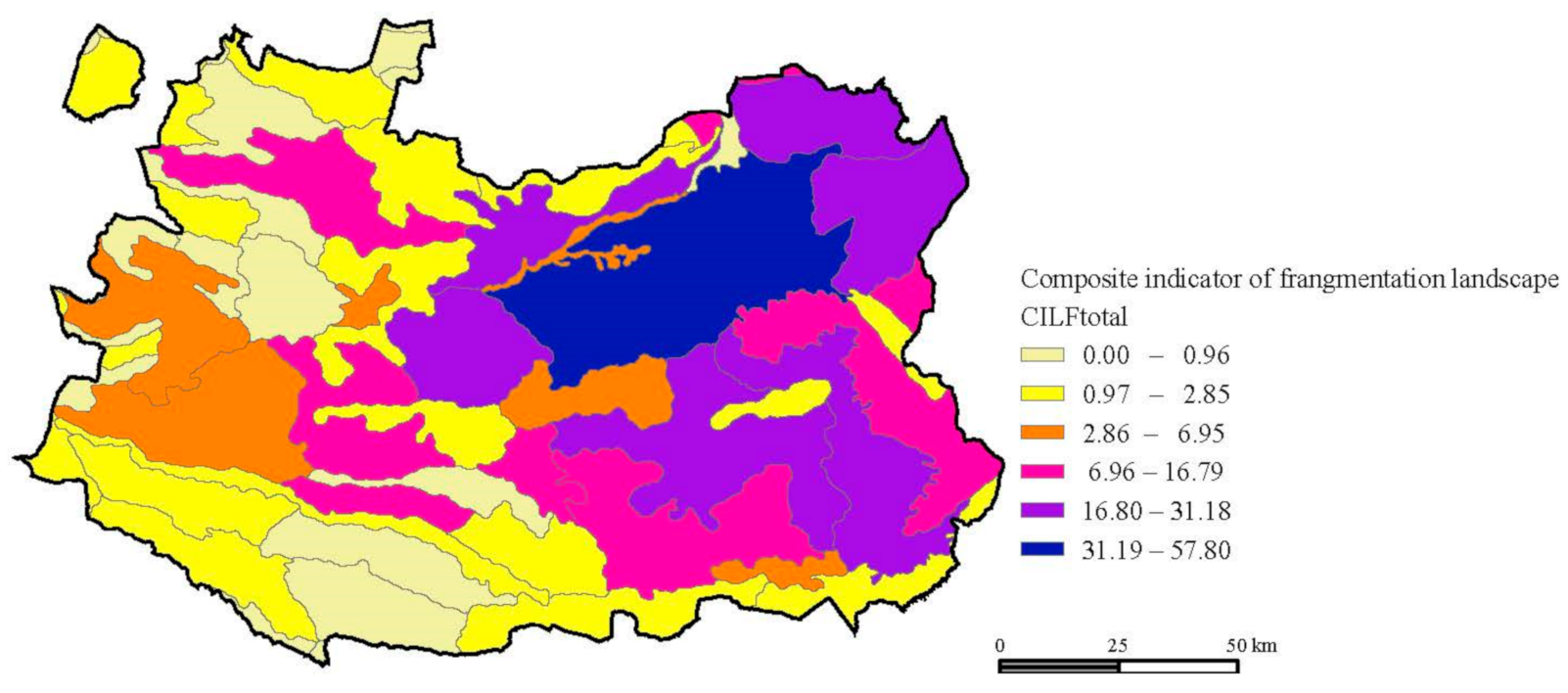
43], arriving at a composite indicator of landscape fragmentation (CILF) approach that seeks synthesis through a single metric by selecting three specific variables or indicators, subsequently normalised and aggregated.
This formulation fits the purpose of understanding the role of rural roads, the urban settlement and the agriculture practices as it allows us to establish an aggregate of fragmenting agents with three origins: transport infrastructure (IFI), urban uses of the territory (UFI); and the division of uses (Seff).
The Infrastructural Fragmentation Index (IFI) has been widely discussed and used in landscape fragmentation studies [
44]. It offers advantages for a synthetic assessment of the fragmentation caused by communication routes. Based on their proposal, we modified the expression to adapt it to our polygon database by applying the following equation:
N and
P relate to the number of patches and the perimeter of a landscape unit.
Si is the area of land referenced as transport infrastructure in the LPIS, weighted by the occlusion coefficient
Oi generated by each type of road. Following the conclusions of Ledda and De Montis [
44], the occlusion values are as shown in
Table 3 and express the different levels of network hierarchy and their impact on the landscape units. Finally,
At is the total area of each landscape unit.
Compared to other applications of this indicator, our proposal includes two novelties. Firstly, the reference unit is the patch formed by homogeneous land use fragments from the LPIS mapping with similar levels of occlusion (structural and functional), which allows for detail in the analysis given the scale. These agricultural land use patches have been formed by merging (dissolving) all those agricultural land use enclosures with a similar level of fragmentation (
Table 3). As explained above, the use of a large-scale vector database solves the limitations of interpreting satellite imagery such as Copernicus or other mapping such as Corine Land Cover, SIOSE (
Sistema de Información sobre Ocupación del Suelo de España, Information System on Spanish Land Use), or Cadastral Cartography.
The second novelty is the substitution of the infrastructure elements in the model as a surface and not as a linear element, taking advantage of the possibilities offered by the data source. In addition, this allows us to include not only traditional communication infrastructure, but also the minor rural network.
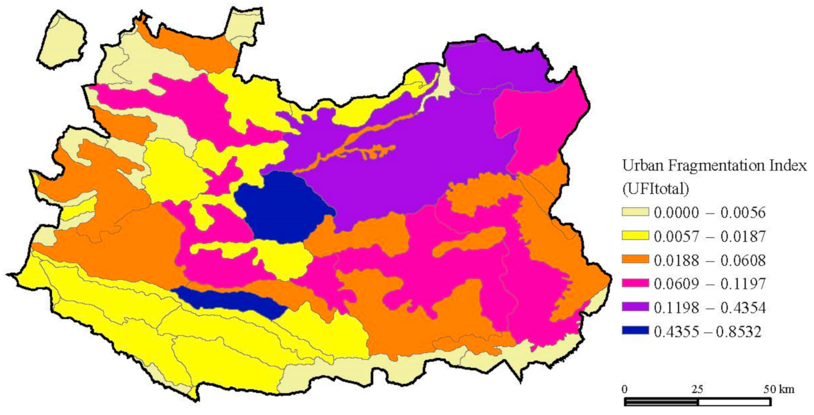
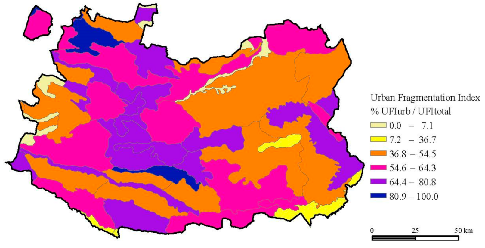
The second indicator used is the Urban Fragmentation Index (
UFI), which assesses the fragmentation generated by urban settlements. Its equation is [
44]:
With respect to former uses of this variable, the novelty in our case is to include other facilities located in the rural matrix that fragment at the same level as populations (e.g., airports, solar energy production plants or the assembly of buildings and facilities scattered in the rural matrix). Si stands for the surface of the urban zones considered, A is the total area of the landscape unit and pi the perimeter of the urban zones.
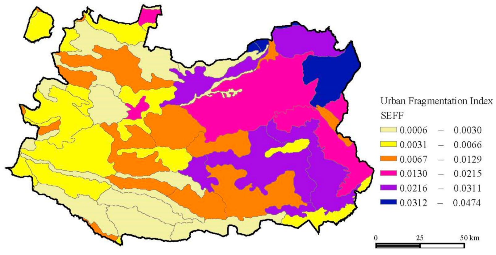
The third fragmentation indicator used is the Effective Mesh Density (
Seff), which values the subdivision of unit of reference, dividing the landscape unit by all the patches we have got dissolved in LPIS according to the criteria aforementioned. Mathematically,
Seff is the inverse of Effective Mesh Size (
Meff):
Following Jaeger [
45],
Meff expresses the probability that two random points may be connected in the study area. It corresponds to the expression:
At is the total area of the landscape unit and Ai is the size of patch i. Consequently, Meff returns a result that measures the fit of the patches to the total area: the closer the patch value is to that of the landscape unit, the lower the Meff value and the lower the fragmentation of the landscape unit.
These metrics are integrated into a composite indicator (CILF), normalising the three indicators according to the min-max algorithm [
41] (p. 5). Unlike De Montis et al. [
41] we use a geometric mean, which does not allow compensation between the indicators:
CILF is the result of the nth root of the normalised product of the i variables in the model. In our case, the value of n is three and the indicators i are IFI, UFI and Seff.
3.4. Fragmentation Layers
Given the characteristics and potential offered by the information source, we can combine different elements that allow us to obtain fragmentation layers (FL). These FLs are simply configurations of the variables that make up the IFI and UFI indicators to interpret the effect of different uses on landscape fragmentation in the study area.
The aim is to approach different geometries that allow us to interpret the impact of certain layers within each category. Jaeger et al. [
27] establish geometries with different sensitivities to elements that pose differentiated obstacles, including or extracting factors from the metrics to analyse the results to these factors. This indicates fragmentation patterns or profiles based on certain starting assumptions. Similarly, we will modify the variables that feed the IFI and the UFI to explore our hypotheses (
Table 4): (a) the role of rural roads on fragmentation, and (b) the fragmentation gradient generated on the rural matrix by different land uses. Through this approach, we explore the sensitivity of certain elements and then relate these layers to the patterns of the rural landscape and the units delimited by application of the ELC.
Once the GIS layer with the patch information has been generated, it is possible to operate with it to obtain the fragmentation metrics by combining the different elements that make up each FL. Within IFI we use two different hypotheses:
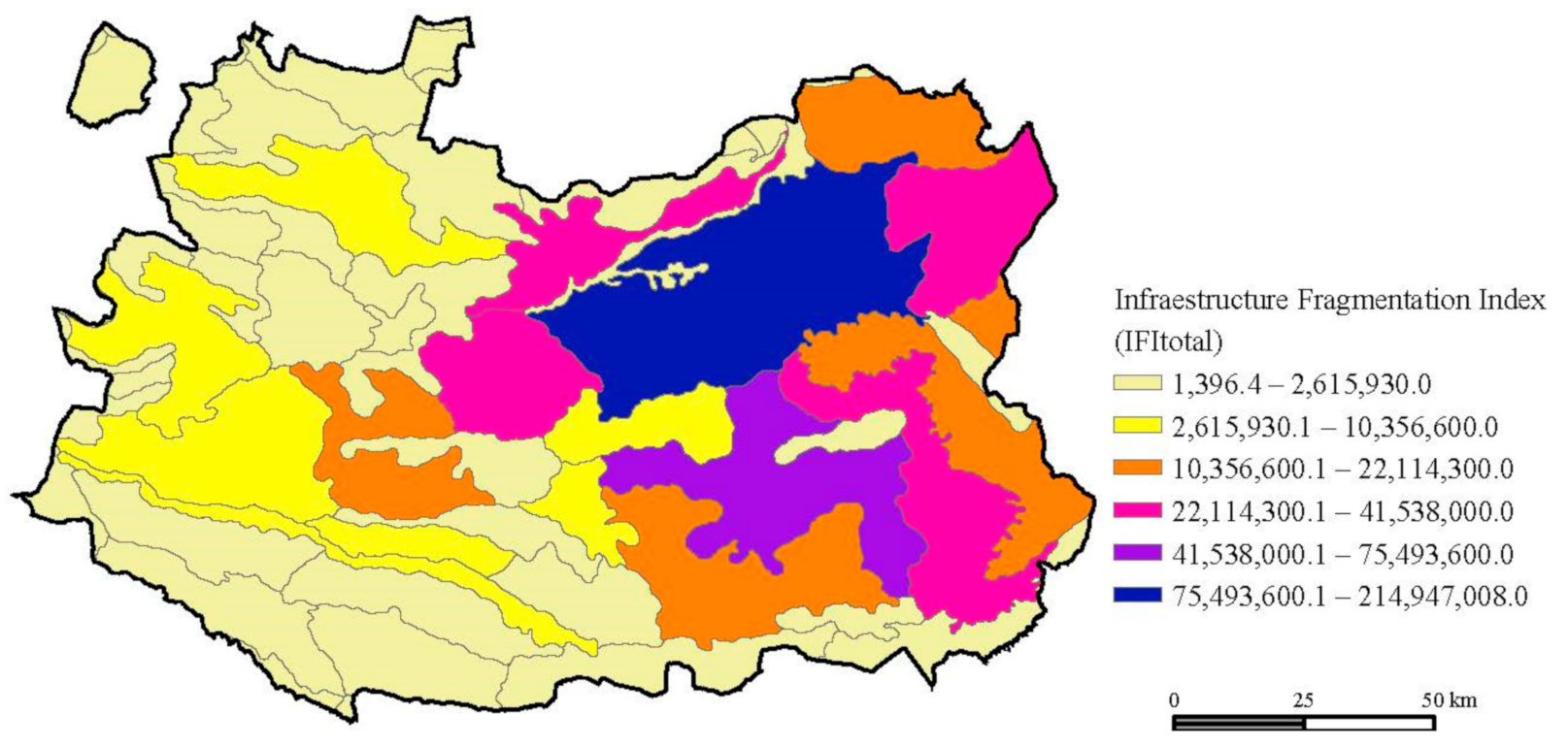
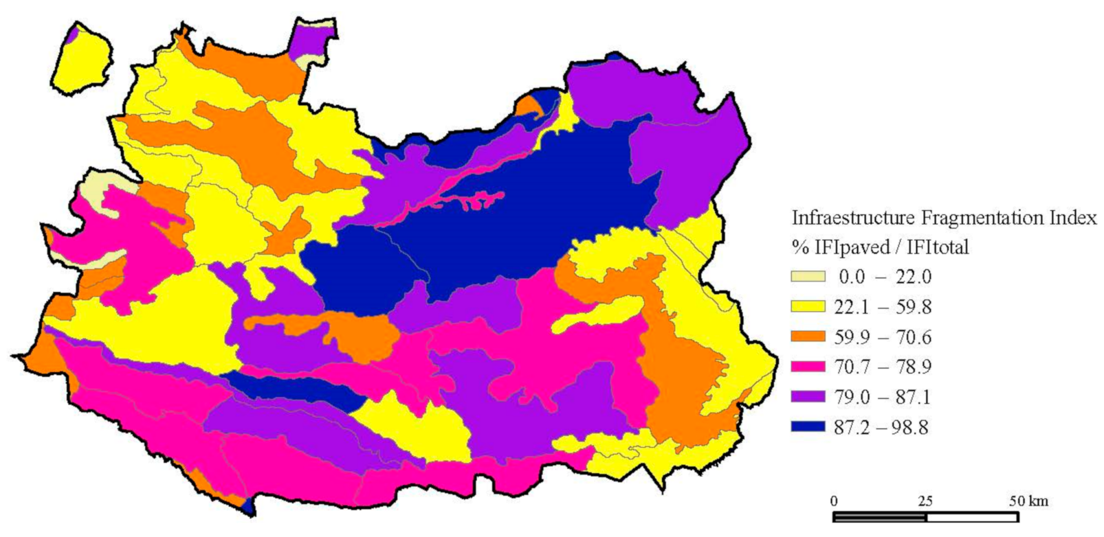
IFITotal would be the indicator containing all the fragmentation infrastructure elements, incorporating all polygons dedicated to a transport use: paved roads, railways, and unpaved minor rural network.
IFIPaved considers only paved roads and railways, whatever their hierarchy. These roads have a higher scale connectivity function, since in the most basic case they are inter-municipal roads, but more frequently we find roads at the regional and national scale.
Comparing the two metrics will help us understand the value of the rural road network. With respect to UFI we establish two layers of interpretation related to the influence that certain land uses have on fragmentation:
- 3.
UFITotal fully incorporates the fragmenting agents derived from urbanisation, including all the typology considered and reflected in
Table 2, which incorporates elements that are not frequent in these analyses.
- 4.
UFIUrb only considers polygons labelled as urban zones within the source and aims to detect the influence of settlements in the context of the different polygons and, subsequently, their relationship with the landscape units.
5. Discussion
The first research question (RQ1) dealt with the dual role of the rural road network, both fragmenting in its condition of anthropic infrastructure, but also with an important role in rural matrix connectivity and its sustainability, consequently, valuing a cultural, agrarian, and traditional landscape. To solve this approach, we developed a battery of indicators that are able to assess fragmentation concisely and separated into different fragmentation elements, thus enabling us to isolate the role of rural roads from other infrastructure elements. We were able to compare IFI indicators with and without minor rural roads at the landscape unit scale. The difference between IFI indicators shows a high sensitivity to this variable, with contributions between 12 and 50% to the overall result, with higher proportion of minor rural roads contributing to fragmentation in landscape units with more traditional profiles (less dynamic agriculture, lower population density and urban functions). In addition to the quantitative impact, it is relevant to talk about the qualitative interpretation of the results, which affect the structure and configuration of the different agricultural domains and landscapes. Traditional rural matrix is more present in those units where the minor rural network has a more impact in landscape fragmentation.
To delve deeper into this discourse, we took advantage of the potential of the information source to also incorporate the different land uses that allow us to establish different agrarian models, either related to intensive and transforming territory dynamics (which fragment the cultural landscape) or related to traditional characteristics within the so-called rural matrix. This was possible thanks to the potential and information scale of the LPIS about land and water use of each parcel of the territory.
In this sense, the results obtained confirm the initial approach: if we have a database in which we can structure the elements of fragmentation, we can see significant differences in the results related to the factors described above. Landscape types with higher total fragmentation show a smaller difference compared to fragmentation with paved infrastructure only. These units are related to areas that tend to have an intensive agriculture profile, higher connectivity from paved roads and railways and a more significant presence of patches with artificial elements. Such units are in the central-east plains in the province, mainly related with “La Mancha” region, where intense agriculture uses are more frequent.
In contrast, the landscape units with the greatest difference between the IFI indices indicate areas with a high density of rural roads, in this case smaller and with less connective characteristics for agricultural uses and a tendency towards extensive uses. These results emphasise the RQ2 approach, which established the potential of the LPIS source for the development of landscape fragmentation analyses. From a technical point of view, this source allows us to develop the most common fragmentation indicators, incorporating not only the values themselves but also the qualitative interpretation associated with the land use that each polygon in the source provides. We are able to recognise the value of the different land uses and relate it to the result of the fragmentation. In other words, we can approach the assessment of different patterns of agricultural use and connect it to the debate on landscape fragmentation and integration. Nevertheless, we claim a more attention about some LPIS land use categories, like “improductivo” (unproductive land use) or “elementos del paisaje” (landscape elements). In both categories, it would be advisable to achieve a more concise definition of the elements included.
This is something we can see in the analysis of the different fragmentation layers related to UFI. In this case, we test the impact of urban uses besides urban settlements, including non-agrarian land uses, fenced areas and isolated buildings and facilities. All of them contribute to landscape fragmentation since are indicative of processes and activities different from the cultural character. Once again, the more dynamic areas in plains showed higher proportion of such patches, demonstrating a more heterogeneous mixture of uses and a more fragmented pattern. On the other hand, areas in the periphery, mountainy peripheries and transitional landscapes showed a lower proportion of such uses. Together with a more impact of minor rural roads we can determine that they contribute to the structure and consolidation of the rural matrix, and its change cause fragmentation, while its presence can be considered a cohesion factor for cultural landscapes.
In comparison to other application of CILF by De Montis et al. [
41] our input shows a different perspective. Because of the nature of the LPIS data source we introduced infrastructures as areas instead of lines and land use information allowed us to qualify the nature of landscape fragmentation. On the other hand, we are not able to add a temporal perspective, which is a limitation as we comment in the next section. Additionally, the scale of our analysis allows a high detail since the data source refers to parcels.
6. Conclusions
The fragmentation of cultural landscapes is a phenomenon that can be interpreted as a gradient and in different ways depending on the factors considered. The heterogeneity of these spaces generates different dynamics, whereby some uses affect others and, consequently, there will be fragmentation. Serrano et al. [
7] pointed out that fragmentation is the loss of landscape connectivity, but this consideration is limiting in the context of cultural landscapes, which are characterised by the multifunctionality of their elements and the difficult balance between these. For these authors, agriculture is an agent of fragmentation, as are transport infrastructure and urban development. In our opinion, these processes have an ambivalent interpretation in cultural landscapes, since fragmentation is a dual process that generates disintegration and cohesion at the same time. Our results showed that those units with a more traditional structure have a considerable proportion of fragmentation due to the minor rural network. In our opinion, such fragmentation must be interpreted qualitatively because, in fact, it contributes to spatial cohesion of the rural matrix and, consequently, to the structure of the cultural landscape.
Fragmentation, understood from a dynamic and multifunctional approach, speaks of the dynamics of the landscape in all its components, it speaks of internal heterogeneity in relation to uses that become dominant at the expense of others that are reduced and isolated, whether natural or cultural, or even both [
10]. Elements such as major roads, railways, urban settlements and specific land uses with activities with higher fragmentation impact (solar power plants, fenced activities) constitute a land use change which affects also to the cultural landscape of these units.
Our study approach shows limitations, land use change is a slow process, so including a temporal perspective and dynamics is complex with our data source and more detail can be added conducting a sensitivity analysis on factors and weighting the indicators, including to achieve more accuracy measuring landscape fragmentation. The use of the LPIS data offered us a highly detailed source that we approached to test our hypothesis, but is also much focused on agriculture elements, reducing its usefulness when urban dynamics are important, for example where solar power plants appear (these facilities are strong elements of fragmentation and tend to aggregate in the territory). We are aware that the potential of it opens several options for further investigation, along with a more in-depth analysis of the factors analysed here. Land use and its relationship with landscape fragmentation might be further explored in the search of relations between land use activities and landscape structures, not only fragmentation. This reveals the usefulness of the LPIS for obtaining results that can be applied to strengthen knowledge about landscape character and structure, but also to obtain useful indicators in landscape management and applying the ELC.


