1. Introduction
Terraces, a widespread agricultural system, has been known since Neolithic times. We find them in Europe, Asia, Africa and the Americas, as they are particularly suited to cultivate steep hills and mountainous areas. The study and conservation of terraces has become an important topic for sustainable development since the United Nations (UN) conference on environment and development held in Rio de Janeiro in 1992. Agenda 21 [
1], the operational document produced during the conference, demonstrated the need to preserve traditional practices and landscapes, as well as the cultural heritage of the local populations. In the following years, terraces became an important concern of the United Nations, in programs such as the United Nations Educational, Scientific and Cultural Organization (UNESCO) World Heritage List in the category of cultural landscapes; the Food and Agriculture Organization of the UN (FAO); and the Globally Important Agricultural Heritage System program. Moreover, terraces became the focus of activities run by the Convention on Biological Diversity concerning indigenous knowledge and the UNESCO-CBD Joint Program on the Linkages between Cultural and Biological Diversity.
In Europe, the conservation of terraces is a part of the Common Agricultural Policies, according to the targets concerning the conservation of the landscape assets of the European rural territory, the conservation of the rural heritage and the need to identify the landscape elements in each country. In Italy, terraces are directly preserved by the National Register of Historical Rural Landscapes and Traditional Practices, established by the Ministry of Agriculture Food and Forestry Policies and protected, with economic incentives for farmers, by the agricultural policy. More generally, according to FAO, the study of terraces is related with the need to increase agricultural production by 70% by 2050. The possibility of restoring abandoned terraces or building new ones is also a major concern. In view of climate change and the possible rise of sea water, more land will need to be cultivated; terracing is often the only system applicable to mountainous areas, but also afforestation on mountain slopes has often used this system. However, not much scientific information is available on this topic, since few studies have been carried out in modern agricultural sciences. For these reasons, and for increasing the body of scientific research on terraced landscapes, an International Alliance for Terraced Landscapes (ITLA) has been launched.
2. Historical Information and Aim of the Research
The construction of terraces is a very ancient practice, recorded as far back as the prehistoric and classical periods, where dry stone walls existed as boundaries between properties [
2].
Consistently with its orographic development, geographical position, and main climatic features, the application of the terracing technique has always been widely used in the Italian peninsula, spreading from the Alpine chain all the way to the islands. Among the Mediterranean countries, only Greece, Lebanon, Spain, Syria and, parts of France have a similar or more significant intensity of terraced landscapes [
3,
4,
5].
The existence and importance of terracing systems in Italy dates back to Neolithic times, and has been extensively documented since the year 1000. It was during the Early Middle Ages (8th century AD) that the technical−scientific contribution made by the Arab world led to a further development in terraced agriculture. Around the 12th century, new techniques were developed to protect soil from erosion and runoff; from the Renaissance (14th–15th century) terraces had become so widespread as to represent a characteristic feature of the agricultural landscape.
Later, the development and the extension of the terraces went hand-in-hand with population fluctuations, following the contractions and expansions of the agricultural surface area caused by the plagues that struck Italy in the 14th and 17th centuries. Then, in the 18th century, there was an upturn linked to a new repopulation of the countryside, and a renewed interest in more complex agronomic science and techniques, such as the art of landscaping in the hills and mountains [
6].
The period from the beginning of the 19th century up to the early years of the 20th century marked the maximum expansion of the agricultural surface area, linked to demographic growth and an upsurge in land hunger. The increase in terraced surfaces for cultivation on mountainous and hilly terrain was accompanied by a notable rise in the rural population, which went up from 5 million to 8,500,000 inhabitants between 1861 and 1951 [
7]. Since the 1960s, the development of industrial agriculture and the abandonment of the countryside have led to the deterioration and sometimes even the disappearance of traditional practices [
8]. In most of the country, the terraced landscapes lost their original function, with the exception of particular areas in which their function has been preserved or renewed for specific reasons, such as the growing of precious crops. This type of abandonment is not restricted to Italy [
9,
10], as is confirmed in literature [
11,
12,
13,
14,
15,
16,
17,
18].
The abandonment of terraces and the difficulties of restoring them is not only due to the reduction of farmed land and economic development, but also to the policies carried out in agriculture, forestry and in nature conservation in Europe and Italy. Agricultural policies have encouraged the gradual abandonment of traditional farming systems, which are less important from economic and productive points of view but crucial as far as the landscape is concerned. In terms of surface area, we are seeing an increase in woodlands in all the areas abandoned by farming. The rate of forest advance in Western and Central Europe is about 800,000 ha/year [
19]; in Italy, the forest advances at a rate of about 75,000 ha/year. However, environmental policies protect and encourage the advancement of forests, usually referred to as renaturalization, while the restoration of previous farmed land that removes the forest is forbidden [
20]. In Italy, the analysis of 120 sites, classified as historical rural landscapes, indicates that 60% are also partly included in protected areas and sites of the Natura 2000 network, including many terraced areas. The assessment of vulnerability to the historical landscape shows that the most important threats are not urbanization or industrial agriculture, but rather abandonment followed by reforestation [
21]. Although nature protection is not the main cause of the degradation of cultural landscapes, neglecting cultural values in favor of natural values has put them in great danger. This is also the case of reforestation occurring on terraces, usually favored and protected, despite the important role played in the reduction of hydrogeological risk. These transformations of the traditional agricultural landscape led to the gradual disappearance of natural structures that had represented an important value in the social perception of the local population, not only as an expression of cultural identity but also as a reference to the sustainable management of the rural territory, ruling changes and reduction of degradation.
Various social categories may have a different awareness of landscape changes, as demonstrated by previous research carried out in Tuscany in 2002 [
22]. Farmers have the highest perception of landscape change, followed by the other residents. The majority of tourists, however, think that the landscape has remained unchanged.
A mapping of the sharecropping landscapes of central Italy, produced in the 1950s by the French geographer Henri Desplanques [
23], showed that the entire hilly region of central Tuscany was affected by extended land utilizations such as embankments and terracing. The levelled terraces were used for the customary rotation crops (cereals, fodder,
etc.) in line with the traditional canons of mixed-crop cultivation; in the inventory of Pan-European landscapes [
24] this was classified as the most typical of Tuscany. This minute patterning of the agricultural landscape was accomplished by the sharecropping society, bringing to completion a laborious process continued over the centuries by different civilizations, political and social organizations, economies, cultures and traditions.
Between the 1970s and the 1990s, with the collapse of the agricultural system based on sharecropping, the destinies of the three components of mixed-crop cultivation became divided: the arable crops were greatly extended, the olive groves survived through inertia, and the vineyards became specialized. From the 1990s onward, the growing attention towards quality products, combined with policies for water and soil conservation, directed the management decisions of the farms towards some restoration of the ancient terraces, making them susceptible to and potentially suitable for mechanized work [
25].
The discussion on water and soil conservation that emerged in the 18th and 19th centuries endorsed the role of Tuscany as one of the most interesting territorial workshops in terms of historic evidence of the construction and management of terraced systems [
26,
27]. Given the historical and cultural significance of these agricultural landscapes, we need to expand our knowledge through an integrated and multidisciplinary approach. On the basis of these considerations, the aim of this research has been to draw up a quantitative analysis of the agricultural terraced landscapes in Tuscany, in line with the approaches and experiences implemented both at the European level [
28,
29] and within Italy [
30,
31].
We have therefore sought to make a survey of the terraced landscapes used for agriculture at the regional level, bearing in mind what was done in Liguria [
32], Veneto [
33], Sicily [
34,
35] and Calabria [
36], although in limited areas. Also in Tuscany, previous investigations were limited solely to specific districts (Chianti and the Province of Pisa), without offering an overall territorial cataloging [
37,
38].
Over the last few years, in order to analyze agricultural terraces in terms of their expansion and varying intensity, different and new technologies related to Geographic Information System (GIS) software have been used [
39]. Traditionally, the more widespread materials are the orthorectified and geo-referenced aerial photographs [
40] and high-resolution satellite images [
41,
42]. Recently, LiDAR data offer new and interesting opportunities for investigating terraces covered by shrubs and trees as a result of their abandonment or for carrying out hydrogeomorphological analysis [
43,
44]. Finally, high-resolution Digital Terrain Models (DTM) or Digital Elevation Models (DEM) can be used to extract agricultural terraces or other morphological features with automatic methods [
45,
46].
The objective of this research is to provide indications about the geo-referencing of the sites with the highest value of intensity index (expressed in linear meters per hectare), the prevailing crop systems, and the principal environmental parameters. In the future, these results can offer useful cues for further investigations into the type and state of preservation of the dry stone walls, thereby suggesting appropriate criteria for the protection and resolution of the existing criticalities, as well as restricting the hydrogeological risks and those of productive and landscape deterioration connected with the abandonment of the water and soil conservation practices. At the national level, this research will also contribute to the activity of the National Register of Historical Rural Landscapes and Traditional Practices established at the Ministry of Agriculture, Food and Forest Policies, and the current Italian agricultural policies. The rate of conservation of historical rural landscapes is one of the indicators of the well-being of the Italian population.
3. Experimental Section
The methodology of the research was defined for both a quantitative analysis of the agricultural terraced landscapes at the regional scale and for the identification of the sample areas that were more representative in terms of intensity index. This will allow the study of the typological features (dimensional parameters, type, state of preservation, etc.) of the more significant entities recorded, given the complexity of performing a census of the agricultural terraced systems of the whole territory.
3.1. Materials
The research protocol was developed in various phases, which were strictly sequential. In the first place, the computer and cartographic instruments for the methodological approach were identified. The assessment of the terraced agricultural systems was conducted in a GIS (Geographic Information System) environment using ArcGIS 9.3 (ESRI) for the management of the information layers necessary for the territorial analysis. Specifically, in addition to the specialized software, the following data were used: the geo-referenced Regional Technical Map (CTR 1:10,000) of Tuscany region in raster and vector format (2003), from which the linear and points coverages refer to the dry stone walls, contour lines and elevation points of the whole region extrapolated; the orthorectified and geo-referenced aerial photographs (1:10,000) of the regional territory (2007) with resolution equal to 50 cm; the Corine Land Cover 2006 IV level (1:100,000, minimum mappable unit equal to 25 ha) for land use [
47,
48] and the landscape regional contexts of the Piano d’Indirizzo Territoriale 2005–2010 (PIT—Territorial Policy Plan) of Tuscany in vector format [
49]. The result of this work should contribute to the implementation of the PIT and to the definition of strategies and actions that are specific to each context. The plan also considers terraced areas, but without developing specific layers or statistics. Overlapping sample areas to the regional contexts will help the PIT understand the importance of terracing and designate proper strategies and actions.
3.2. Methodology
For the study of the quantitative distribution of the terraced landscapes at the regional scale, the methodology carried out spatial analysis in GIS environment (Geoprocessing tools), overlapping the layers of interest. In particular, the dry stone walls layers in relation with the land use, the administrative boundaries of provinces, and regional contexts of PIT were processed.
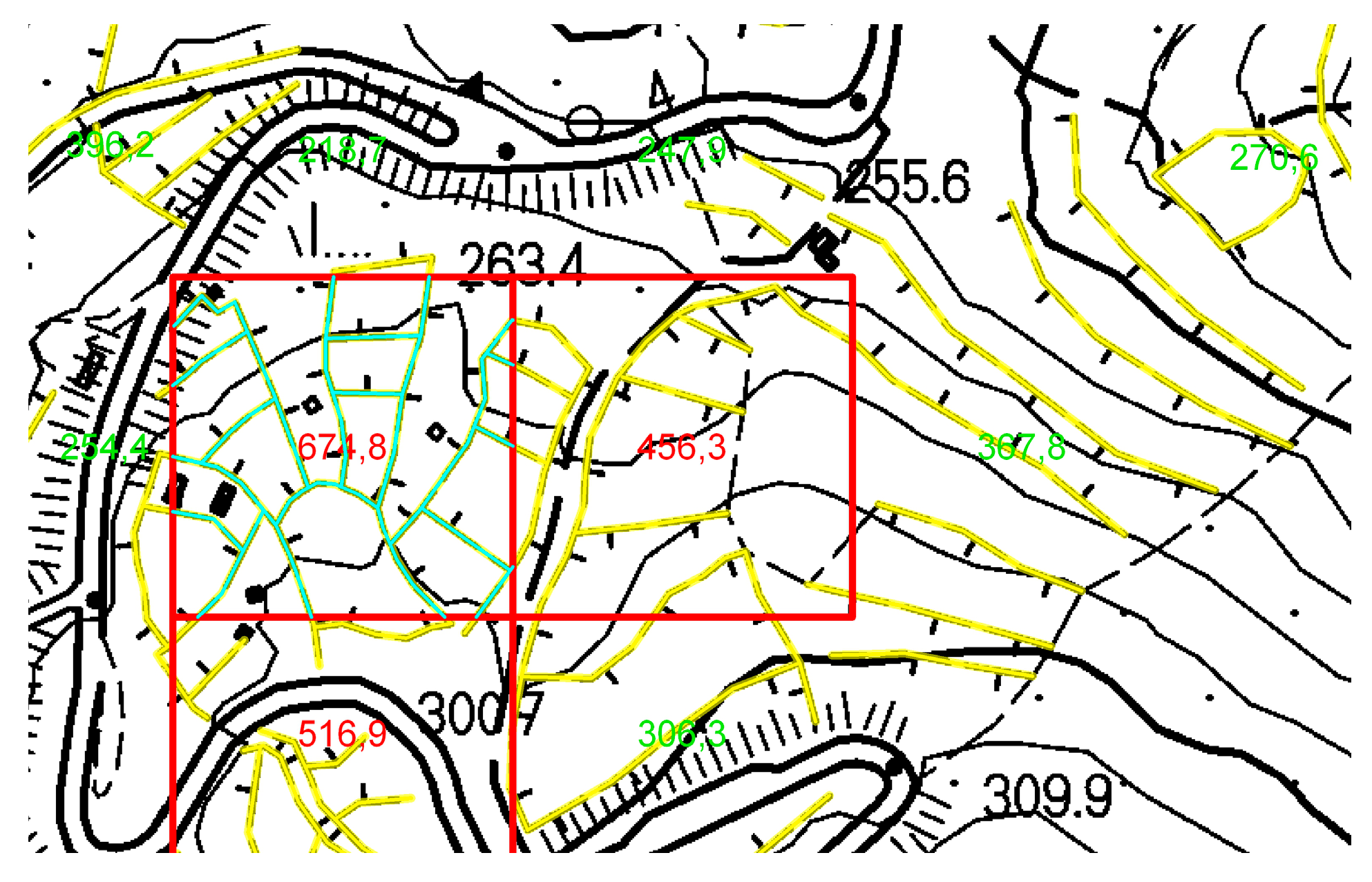
The setting of the methodology for the selection of the sample areas was more difficult. Starting from the linear extension of the dry stone walls, it was possible to calculate the ratio between the surface (1 ha) and the lines representing the walls, so as to obtain an index defined as the terracing intensity index expressed in linear meters per hectare. The procedure for the automatic calculation of the index was carried out, using the line density function, from which an output cell size (raster) was obtained with each a specified intensity value. Conceptually, the function calculates the intensity value of the input polyline features (L1, L2, Ln) that fall within the circular search area multiplied by the population field value (V1, V2, Vn); the total calculation is then divided by the circular area (Ac) itself:
The input polyline features were represented by the shapefile of the dry stone walls, whereas the population field, which specifies the weight of the input polyline features, was not considered since the calculation concerned exclusively the linear extension of the dry stone walls. The method adopted revealed an error of underestimation of the linear element investigated, since the linear elements falling outside the circles were not calculated by the function. On the other hand, constructing a circle circumscribed to a 1 ha cell, the circular areas were overlaid, thus overestimating the output datum (
Figure 1).
Figure 1.
Different applications of line density varying the size of the estimate area: (a) raster cell containing the circular area; (b) raster cell circumscribed to the circular area.
Figure 1.
Different applications of line density varying the size of the estimate area: (a) raster cell containing the circular area; (b) raster cell circumscribed to the circular area.
On the basis of these considerations, a square-mesh grid in vector format of a side of 100 m × 100 m was generated in a GIS environment using Create Fishnet (Data Management tools), obtaining a polygonal datum made up of 1 ha cells, which in terms of surface area was considered an appropriate compromise between an excessive simplification and the possibility of maintaining adequate datum specificity. Unlike the results obtained using the automatic calculation procedure, this method proved to be exempt from under and overestimation errors. Through subsequent spatial operations (join and intersect), the layer of the linear elements was cut to the previously created vector grid (
Figure 2), obtaining an output polygonal vector corresponding to the total length of the walls falling within each cell (intensity per hectare). Following these operations it was possible to obtain a value for each cell of the vector grid (102,756 cells in total) varying from 0 m/ha up to a maximum of around 1422 m/ha.
Figure 2.
Output of analysis between square-mesh grid and layer of the dry stone walls.
Figure 2.
Output of analysis between square-mesh grid and layer of the dry stone walls.
Subsequently, the reliability of the processing was also checked (presence and geometry of the linear element), keeping the aerial photos of Tuscany as a reference base, whereby the linear element was necessarily corrected by digitizing the missing elements or modifying the geometries that did not correspond (
Figure 3). Only the forest areas were excluded from the data control, for the inability to verify the presence of the dry stone walls under forest coverage through aerial photos.
Figure 3.
Comparison between (a) the original linear elements and (b) those corrected by editing.
Figure 3.
Comparison between (a) the original linear elements and (b) those corrected by editing.
When checking of all the cells was complete, it was decided to subdivide the intensity values into the categories, according to the one established in other studies carried out in Italy: less than 150 m/ha, between 150 and 400 m/ha, and more than 400 m/ha [
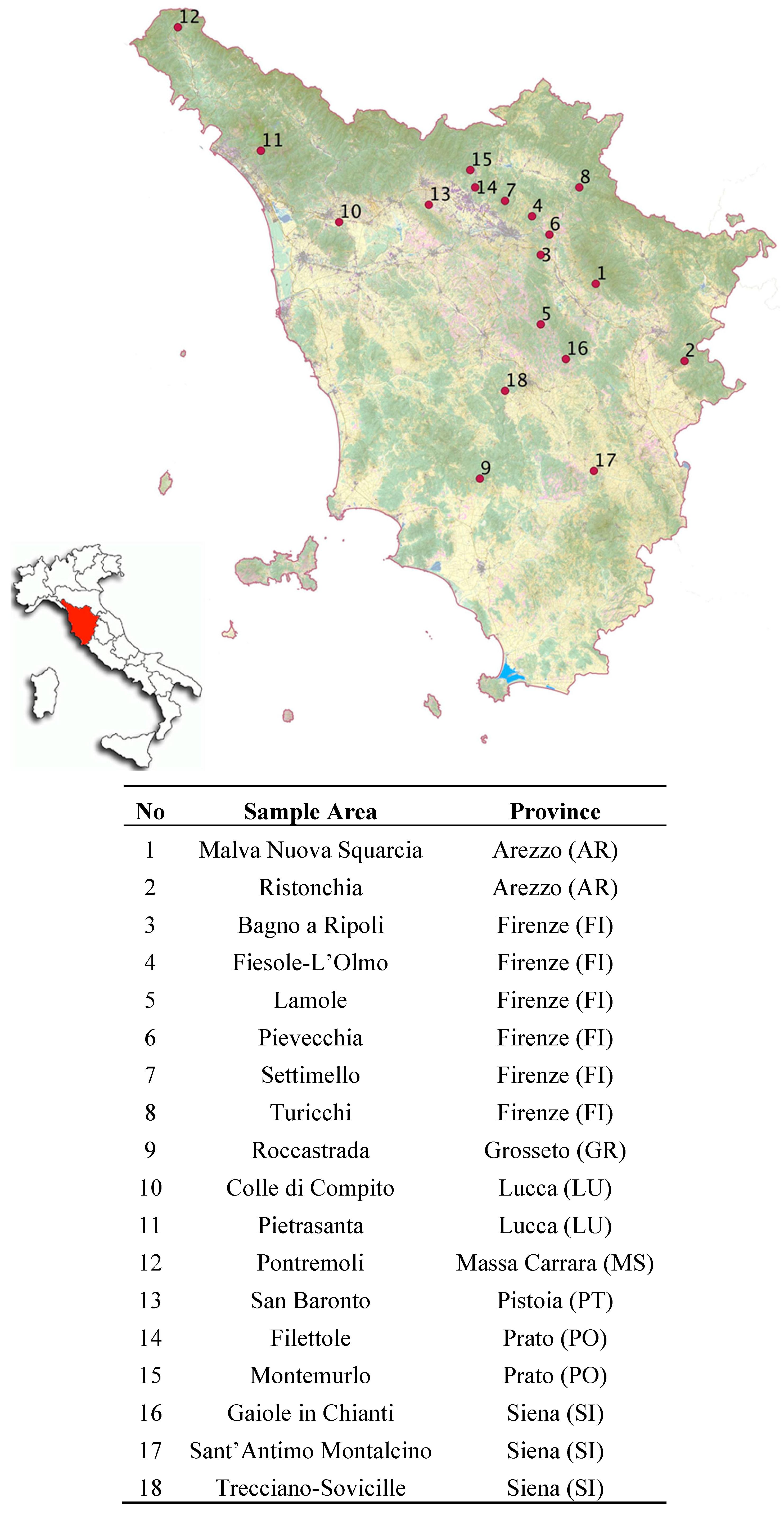
33]. With the aim of identifying certain sample areas where investigation could be further developed, the 18 sample areas (
Figure 4) with the highest intensity index (greater than 400 m/ha) were selected. In this way the terraced systems with higher intensity index were analyzed for their greater importance in terms of economic, agricultural and landscape values at the regional scale. The intensity value selected is also in line with the current technical debate in Italian agricultural policies, concerning the definition of thresholds for subsidies to farmers in terraced areas. In this preliminary approach, we have deliberately ignored scattered or fragmented terraced areas, while recognizing their value. The 18 sample areas were analyzed on the basis of land cover and the main environmental parameters (slope, altitude, and aspect).
In particular, the layers of slopes and aspects were obtained from the contour lines and elevation points of the Regional Technical Map, performed by GIS software, a Triangulated Irregular Network (TIN), which is a 3D vector model of the area. Subsequently, TIN has been turned into raster data, Digital Elevation Model (DEM), through operations of spatial analysis (3D Analyst).
After the location of the sample areas, these areas will be subject to accurate surveys for a qualitative and typological characterization of the dry stone walls.
Figure 4.
Location of the 18 sample areas.
Figure 4.
Location of the 18 sample areas.
4. Results and Discussion
4.1. Quantitative Distribution of the Agricultural Terraced Landscapes at the Regional Scale
Following the extraction of the linear information relating to the dry stone walls from the Regional Technical Map (CTR) vectors, the value of the extension of the terraced systems in relation to the extension of the regional territory as a whole was estimated to be around 4.5% (approximately 102,756 ha).
Taking land use into consideration, according to the nomenclature adopted by the Corine Land Cover 2006, it was possible to observe that 68% of the dry stone walls were situated in what is known as the utilized agricultural areas; 29% in forest and semi-natural areas; and the remaining 3% in artificial surfaces.
From the analysis of the distribution of dry stone walls broken down by province, it emerged that the provinces of Siena (1188.42 km), Massa (1165.14 km), Lucca (1144.89 km), Florence (1075.17 km), Arezzo (965.57 km), and Grosseto (922.93 km) show values approximately 12%–15%, higher than the others, which record values of between 1%–6% (
Figure 5).
Figure 5.
Distribution of the dry stone walls in the Tuscan provinces.
Figure 5.
Distribution of the dry stone walls in the Tuscan provinces.
After this, the linear distribution of the dry stone walls in each province was examined on the basis of land use. The results showed that the territory in which the linear elements of dry stone walls are most common corresponds to surfaces devoted to olive growing for the provinces of Firenze (613.43 km), Arezzo (485.41 km), Lucca (316.75 km), Grosseto (208.32 km), Pisa (201.99 km), Pistoia (200.23 km), Livorno (87.75 km) and Prato (39.91 km). Different results were obtained only for the provinces of Siena, where the complex cultivation patterns (406.97 km) are predominant, and Massa, where the land principally occupied by agriculture with significant areas of natural vegetation (532.32 km) are widespread.
This result is also confirmed at the regional scale, where the greatest presence of dry stone walls is found in agricultural areas with olive groves (CLC2006 class code 223—25%), followed by areas with complex cultivation patterns (CLC2006 class code 242—17%), land principally occupied by agriculture with significant areas of natural vegetation (CLC2006 class code 243—14%), forests largely composed of deciduous oaks (CLC2006 class code 3112—7%), intensive crops (CLC2006 class code 2111—6%), forests with a prevalence of chestnut (CLC2006 class code 3114—5%), transitional woodland-shrub (CLC2006 class code 324—4%), vineyards (CLC2006 class code 221—3%), through to the less represented categories (
Table 1).
Table 1.
Distribution of the dry stone walls according to the CLC 2006 classification at the regional scale.
Table 1.
Distribution of the dry stone walls according to the CLC 2006 classification at the regional scale.
| Code CLC06 | Land Cover | km | % |
|---|
| 223 | Olive groves | 2292.99 | 25.15 |
| 242 | Complex cultivation patterns | 1579.99 | 17.33 |
| 243 | Land principally occupied by agriculture with significant areas of natural vegetation | 1296.85 | 14.22 |
| 3112 | Forest with a prevalence of deciduous oaks (Turkey oak and/or pubescent oak and/or English oak and/or common oak) | 660.49 | 7.24 |
| 2111 | Intensive crops | 574.64 | 6.30 |
| 3114 | Forests with a prevalence of chestnut | 430.17 | 4.72 |
| 324 | Transitional woodland-shrub | 328.03 | 3.6 |
| 221 | Vineyards | 300.00 | 3.29 |
| 112 | Discontinuous urban fabric | 237.62 | 2.61 |
| 3232 | Low maquis and guarrigue | 211.43 | 2.32 |
| 31321 | Mixed coniferous and deciduous forests with a prevalence of Mediterranean pines and cypress (stone pine, cluster pine, Aleppo pine) | 195.65 | 2.15 |
| 231 | Pastures | 158.06 | 1.73 |
| 3111 | Forests with a prevalence of oaks and other broad-leaved evergreens (such as holm oak and cork oak) | 148.60 | 1.63 |
| 3117 | Forests with a prevalence of exotic broadleaved (such as black locust and tree of heaven) | 110.83 | 1.22 |
| 3113 | Mixed forests with a prevalence of prevalence of other autochthonous broadleaved (mesophyll and mesotherm broadleaved such as maple ash, hornbeam, manna ash) | 94.83 | 1.04 |
| 31312 | Mixed coniferous and deciduous forests with a prevalence of deciduous oaks (Turkey oak and/or pubescent oak and/or English oak and/or common oak) | 87.07 | 0.95 |
| 3121 | Forests with a prevalence of Mediterranean pine and cypress (stone pine, cluster pine, Aleppo pine) | 76.49 | 0.84 |
| 2112 | Extensive crops | 59.26 | 0.65 |
| 3211 | Continuous grasslands | 56.81 | 0.62 |
| 3115 | Forests with a prevalence of beech | 52.84 | 0.58 |
| 31314 | Mixed coniferous and deciduous forests with a prevalence of chestnut | 50.16 | 0.55 |
| 3231 | High maquis | 45.76 | 0.50 |
| 241 | Annual crops associated with permanent crops | 44.98 | 0.49 |
| 3212 | Discontinuous grasslands | 25.04 | 0.27 |
| Total | | 9118.62 | 100 |
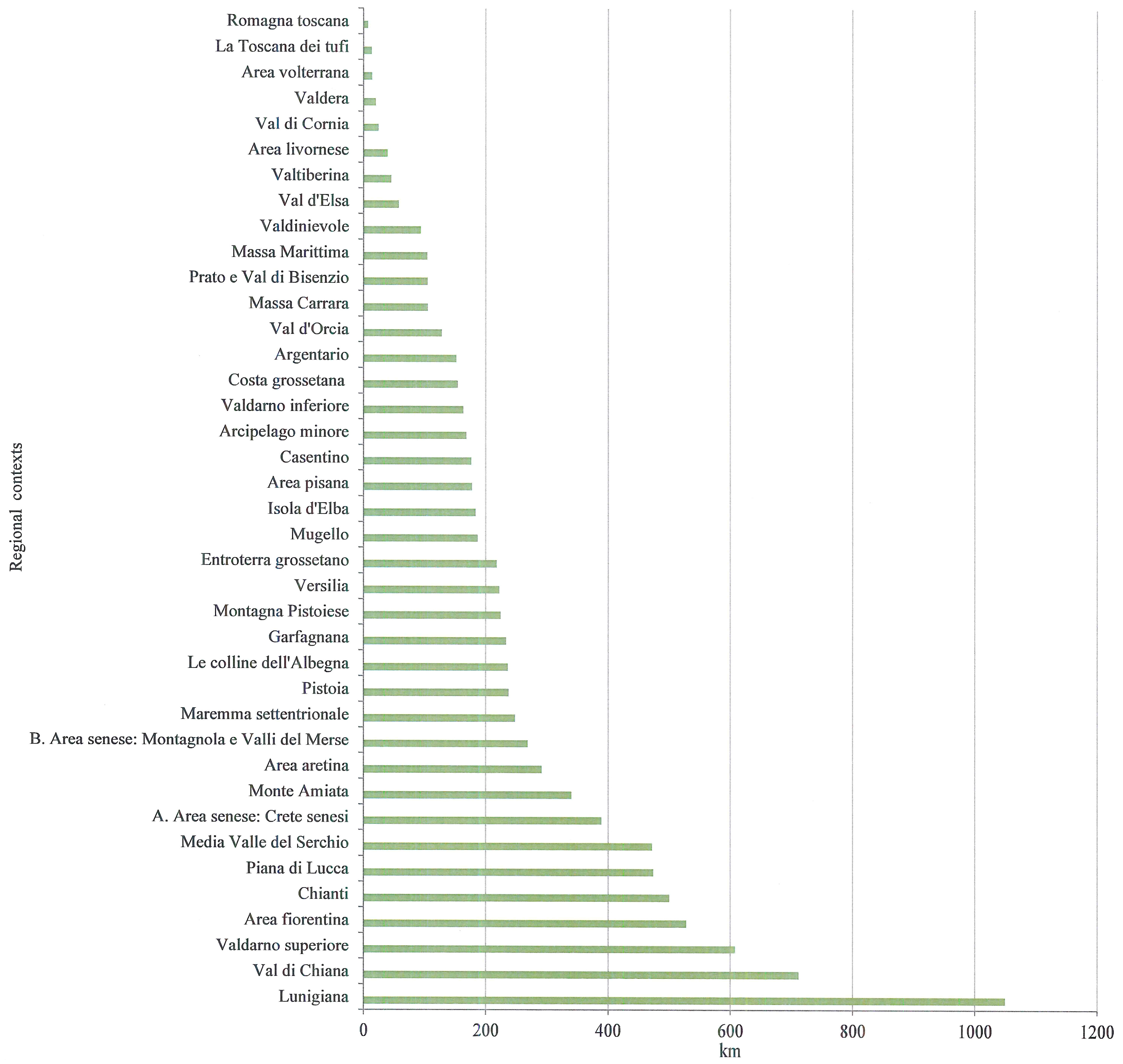
Figure 6 shows a classification based on the 38 landscape regional contexts of the Piano Indirizzo Territoriale (Territorial Policy Plan), which makes it possible to observe how the most representative areas in terms of extension are: Lunigiana (1049.77 km), Val di Chiana (712.05 km), Valdarno Superiore (607.99 km), the Area Fiorentina (528.26 km), Chianti (500.10 km), the Piana di Lucca (473.95 km) and the Media Valle del Serchio (472.03 km). These results help to identify landscape contexts where farming practices, over the centuries, have mostly contributed to draw the patterning of the agricultural landscape and also to define strategies and actions of the PIT for these areas.
Figure 6.
Distribution of the dry stone walls classified according to the landscape regional contexts.
Figure 6.
Distribution of the dry stone walls classified according to the landscape regional contexts.
4.2. Analyses of the Main Environmental Parameters of the Sample Areas
The 18 sample areas obtained, with intensity values comprised between 512.04 m/ha and 1,422 m/ha, cover a surface area of 265.35 ha, 65% of which (173.02 ha) is represented by agricultural areas with olive groves, followed by vineyards with a percentage of around 16% (41.62 ha) (
Table 2).
Further analyses were carried out on these areas to classify them on the basis of slope, altitude and aspect. From the distribution based on classes of slope (
Figure 7) it was possible to observe that the most represented classes are those comprised between 10%–20% and 20%–30% with a total of 200.28 ha, followed by that of 30%–40% with 45.26 ha. The slope value, combined with the width of the terrace and the height of the embankment, could represent a useful parameter for establishing the potential for mechanization of the area, to evaluate the suitability of the terraced systems for rehabilitation or abandon [
25].
Table 2.
Distribution of the sample areas according to the CLC 2006 classification.
Table 2.
Distribution of the sample areas according to the CLC 2006 classification.
| Code CLC06 | Land Cover Types | Area (ha) | % |
|---|
| 223 | Olive groves | 173.02 | 65.20 |
| 221 | Vineyards | 41.62 | 15.68 |
| 242 | Complex cultivation patterns | 17.60 | 6.63 |
| 231 | Pastures | 16.94 | 6.38 |
| 241 | Annual crops associated with permanent crops | 6.30 | 2.39 |
| 2111 | Intensive crops | 4.56 | 1.71 |
| 3111 | Forests with a prevalence of oaks and other broadleaved evergreens (such as holm oak and cork oak) | 3.26 | 1.22 |
| 243 | Land principally occupied by agriculture with significant areas of natural vegetation | 2.05 | 0.79 |
| Total | | 265.35 | 100 |
Figure 7.
Distribution of the sample areas according to slope classes.
Figure 7.
Distribution of the sample areas according to slope classes.
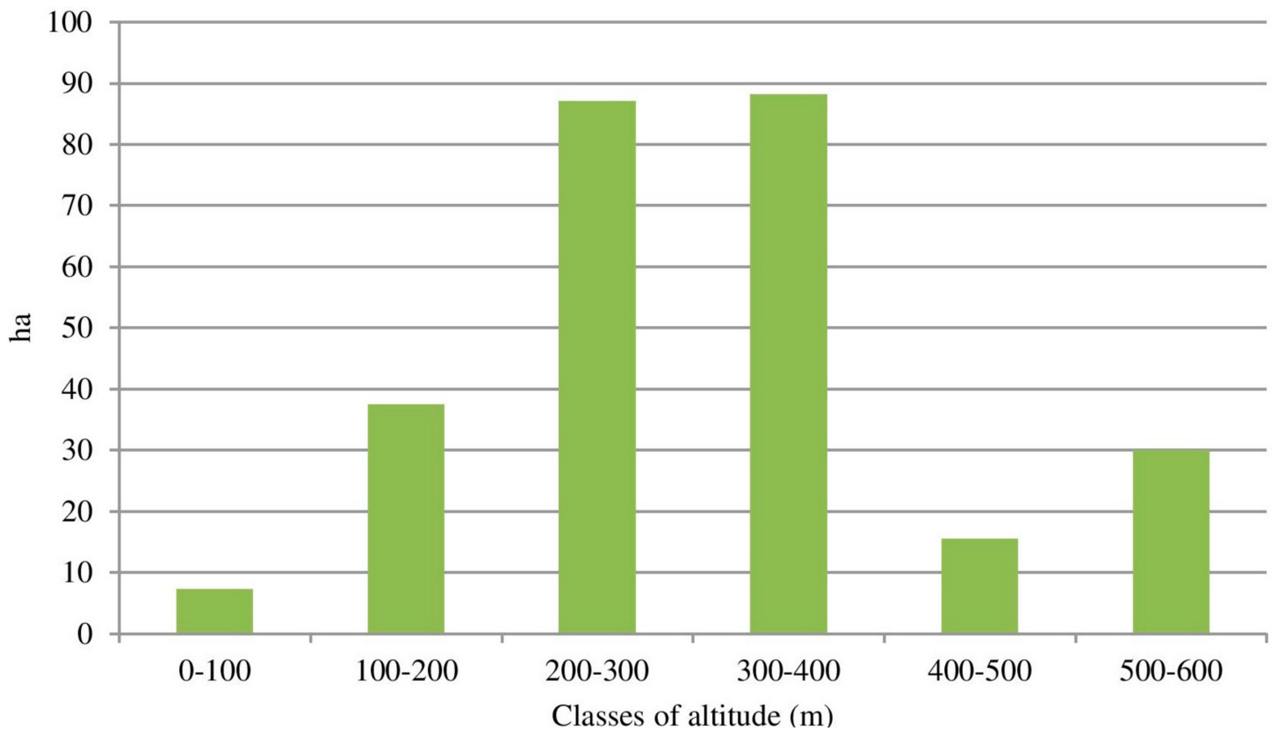
As regards to the distribution by altitude, the sample areas are distributed more in the 200–300 m and 300–400 m hilly range (with a total of 175.18 ha); lower distribution values are found at lower altitudes of 0–100 m and 100–200 m (with a total of 44.79 ha) and at altitudes higher than 400 m (45.38 ha) (
Figure 8).
Figure 8.
Distribution of the sample areas according to altitude classes.
Figure 8.
Distribution of the sample areas according to altitude classes.
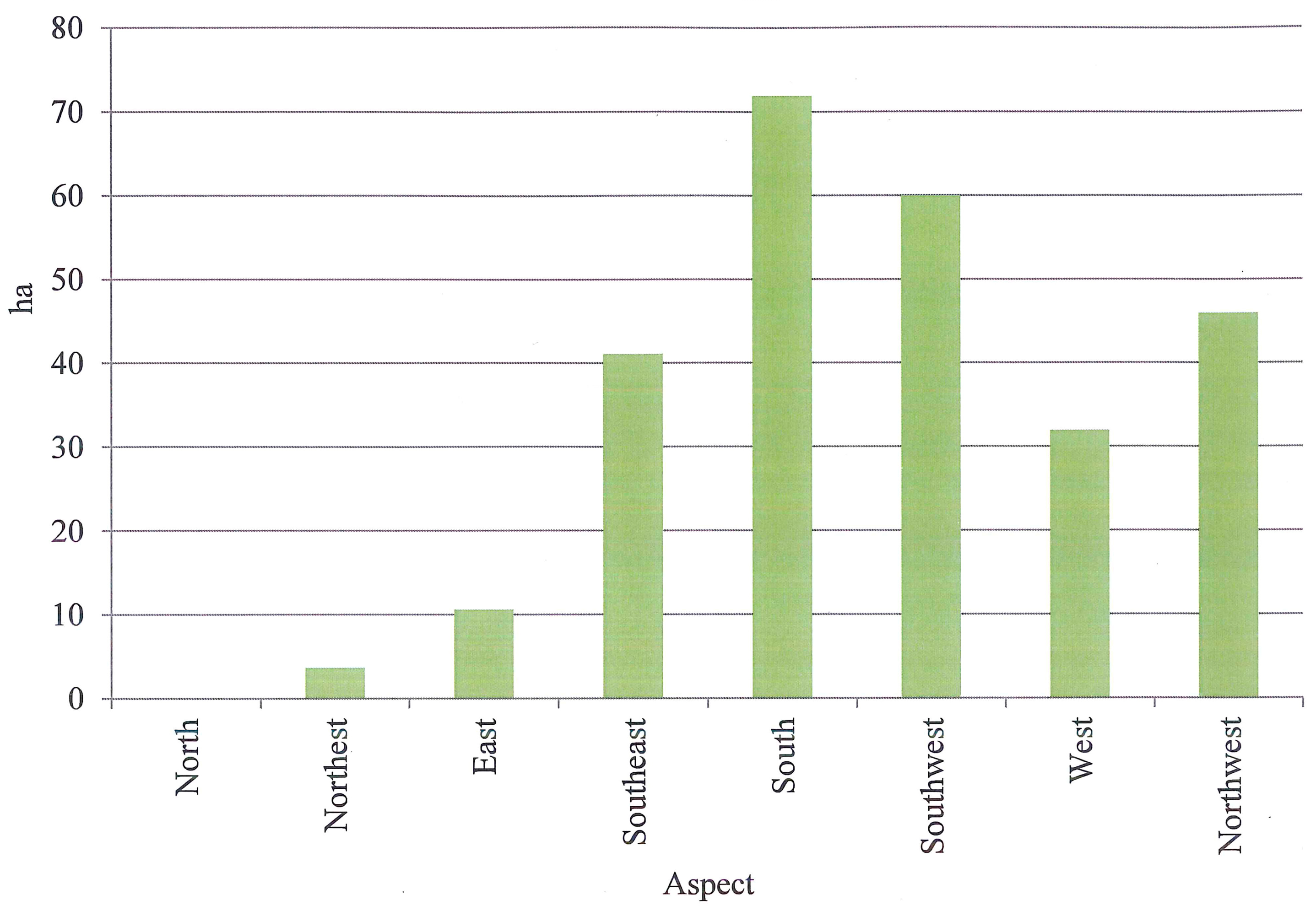
This was followed by an analysis concerning distribution on the basis of aspect (
Figure 9). It is possible to note the prevalence of areas with a southeast/south/southwest aspect (173.06 ha total) compared to others, illustrating the importance of the arrangement of the cropping system in regards to insolation, in terms of the most efficient use of solar energy for the purposes of photosynthesis [
50]. The presence of terraced surfaces (approximately 50 ha) with northeast/northwest aspect should also be noted.
Analyzing more specifically the terraced areas with olive groves and vineyards, in view of their importance in the 18 sample areas, it was possible to note that olive growing is more widely distributed in the slope classes comprised between 10%–40% (164.82 ha) and at altitudes comprised between 100–400 m (167.72 ha), whereas viticulture is present in slope classes between 10%–30% (41.62 ha) and around altitudes of 400–600 m (37.93 ha).
Figure 9.
Distribution of the sample areas according to aspect.
Figure 9.
Distribution of the sample areas according to aspect.
It is difficult to compare these results with those of other Italian regions carried out in limited areas with a high continuity of distribution. Nevertheless, it should be remembered that the olive terraced areas of Costa Viola (Calabria) are distributed more or less equally between slopes of 10%–40% and in altitude ranging between 300–500 m [
36], while other surveys carried out in Veneto (Alps and Pre-Alps) have shown that two-thirds of the terraced areas are characterized by the association of several crops, with a prevalent use of vineyards at relatively higher altitude [
33]. In Liguria two dominant crops, vineyards and olive groves, in agricultural terraced landscapes were found. However, the vineyard was more prevalent than the olive grove, which was present only in abandoned areas [
32].
5. Conclusions
This research presents an initial investigation regarding the terraced heritage of Tuscany, offering a quantitative evaluation of the investigated population. For this approach, the use of Geographic Information Systems (GIS) was essential, —a powerful instrument for the analysis of the data, correlating the presence of terraced systems with different information layers in order to arrive at the definition of the most representative sample areas. From the results, it emerged that 4.5% of the regional territory is occupied by terraced systems, largely used for agricultural purposes; the agricultural areas occupied by olive groves (25%) proved to be the most representative category of land cover. This finding is confirmed at the provincial scale, except for the provinces of Siena and Massa.
The definition of the terracing intensity index and the subsequent quantitative analyses carried out on the 18 sample areas, with high values of terracing intensity, enabled observations regarding land use and the main environmental parameters. The terracing intensity index can be considered a first indicator useful for assessing the landscape value of the terrace, in order to analyze the terraced systems widely distributed, in terms of extension, and deliberately ignoring fragmented or scattered terraced areas.
From sample areas the analysis showed that: 65% of surface is represented by agricultural areas with olive groves, the slope classes most represented are those comprised between 10%–20% and 20%–30%, the altitude classes most represented are distributed in the 200–300 m and 300–400 m hilly range with prevalence of areas with southeast/south/southwest aspect.
Clearly the census of the 18 sample areas represents only a preliminary picture of the situation at the regional scale; nevertheless, it represents an important basis both for the National Register of Historical Rural Landscapes and Traditional Agricultural Practices, established at the Italian Ministry of Agriculture, Food and Forestry Policies and for the application of a standard of Cross-Compliance intended by national agricultural policies in relation to the agricultural landscape. Moreover, the information about the diffusion and the state of preservation of terraced landscapes allows for assessment of the costs of maintenance and rehabilitation, in relation both to the grants provided to farmers using traditional systems that are compatible with the landscape, and in terms of the reduction of hydrogeological risk. In some terraced areas of Tuscany (Chianti), new agricultural landscapes can be observed, thereby illustrating that the protection of landscapes can be performed not only through restoration operations but much more extensively by building systems. These systems must function in continuity with the past partly by following traditional customs and partly by innovating them.
Despite the dynamism of rural territory, as a result of agricultural and forestry practices and socioeconomic processes, it is necessary to preserve and enhance the typical landscapes of Tuscany. Tuscan landscapes have taken on a social and environmental value, as well as a productive one, which is newly recognized by different stakeholders. Therefore the landscape is a complex resource, with cultural, social and economic impact, that requires strategic planning for the development of rural areas. For the public administration bodies assigned to the implementation of policies for management of the territory, the drafting of Territorial Information Systems will make it possible to avail of a dynamic information archive, indispensable for the cataloging and updating of the information gathered.
Future developments will focus on further investigations in other sample areas with high terracing intensity index. As the first 18 sample areas, these areas will be subject to accurate surveys for a qualitative and typological characterization of terraced systems and dry stone walls, including the present land use and conservation status (status of the agricultural crops, abandonment processes, etc.). On the basis of these further investigations, it will be possible to identify environmental units at the regional scale, classified not only by criteria of homogeneity extension but also for typological characteristics (in terms of construction, management, historical and cultural aspects). Starting from the identification of these homogeneous units, it will be possible to extend the investigation until reaching a full classification of the agricultural terraced landscape of Tuscany.


