
Sustainable Ecosystem Services Framework for Tropical Catchment Management: A Review


 ,
,
Abstract
:1. Introduction
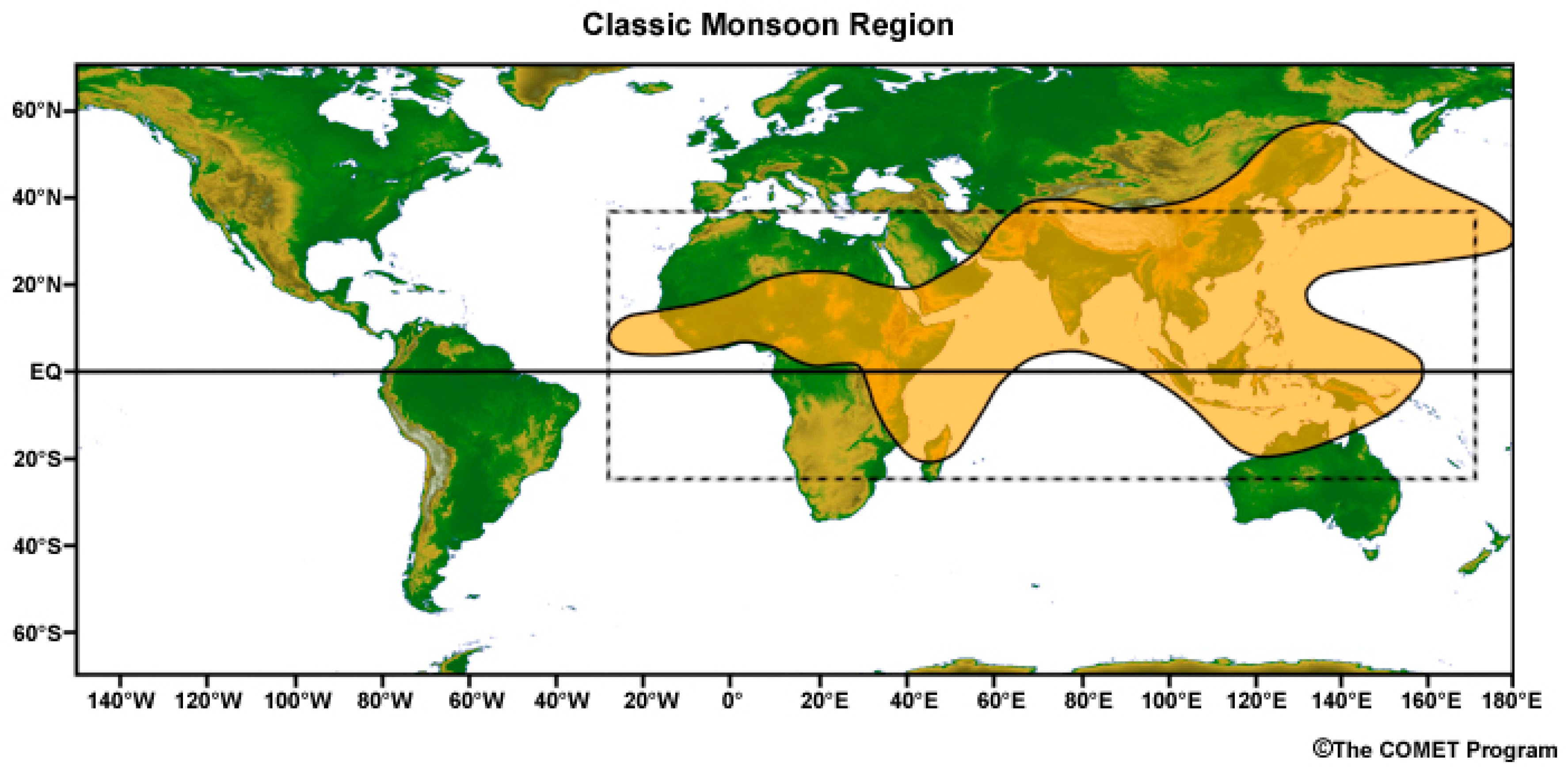
2. The Tropical Monsoon in the Southeast Asian Region
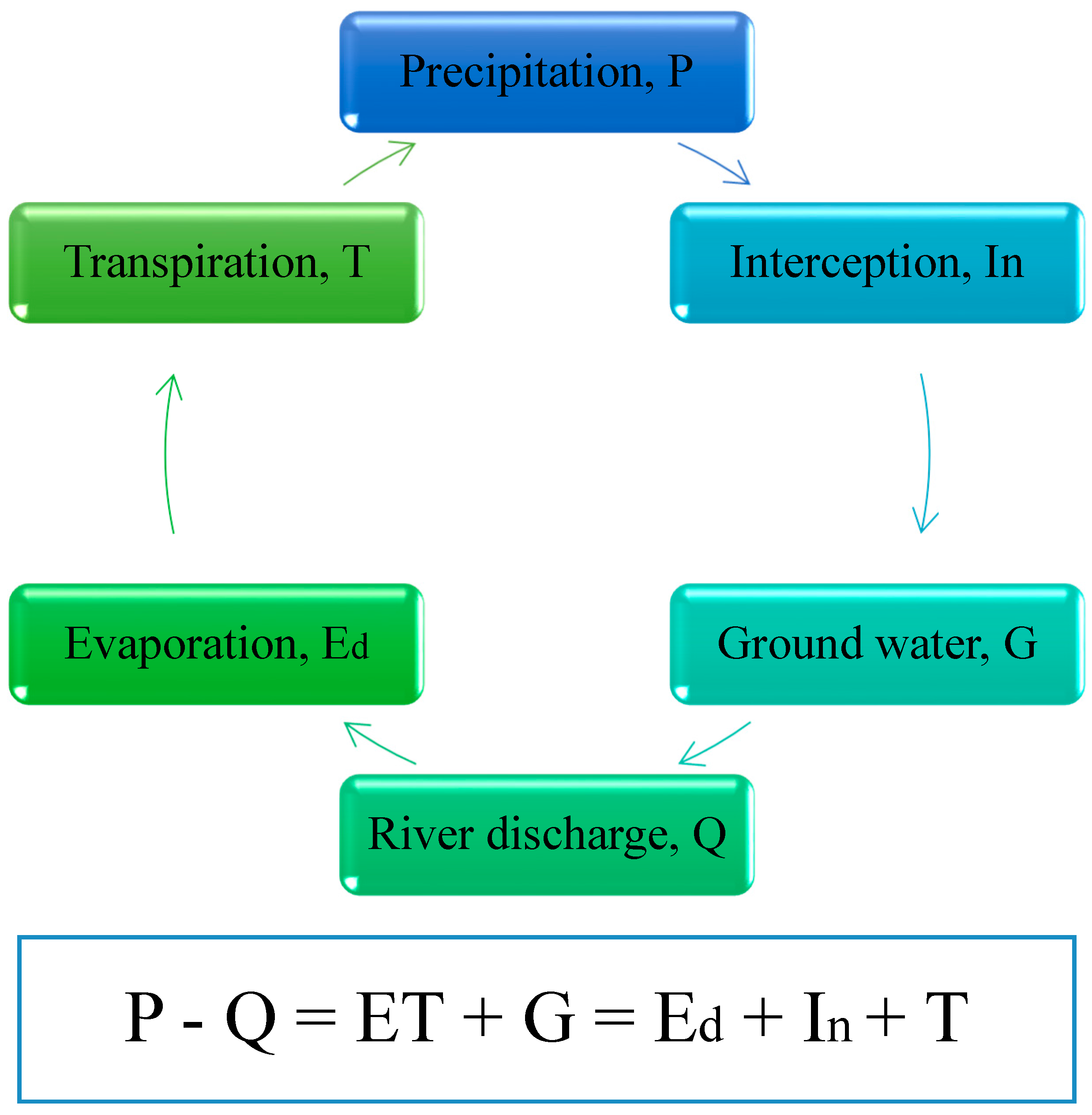
3. Water Input in Tropical Watersheds
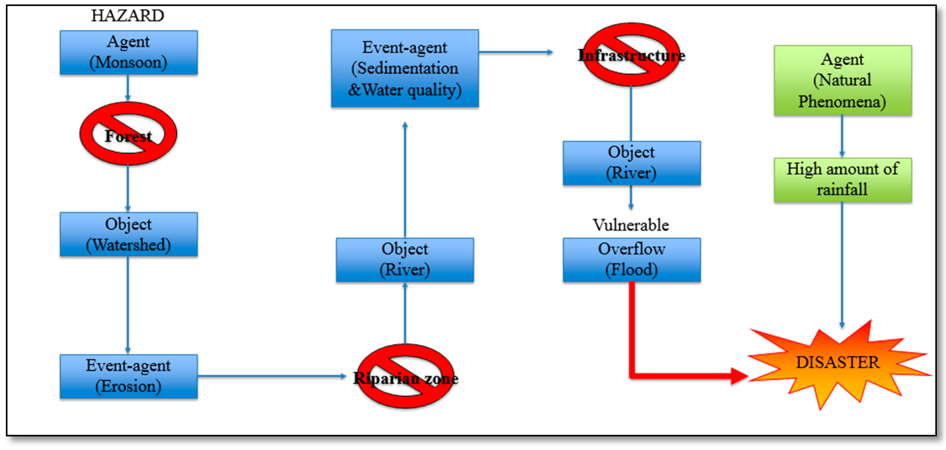
4. Flood Event
5. Ecosystem Services of Tropical Forest
5.1. Flood Regulation
5.2. Erosion Regulation
6. Soil Erosion and Sedimentation Process
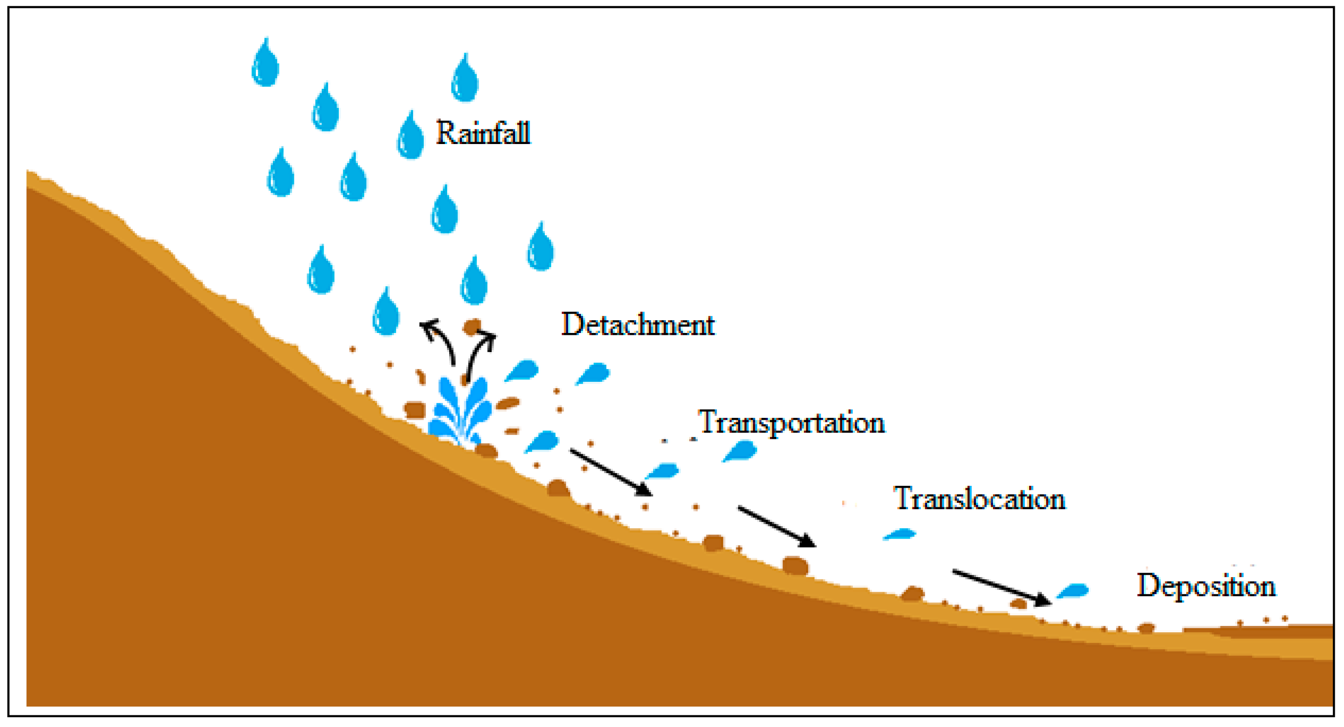
7. Mechanism of Soil Erosion and Sedimentation
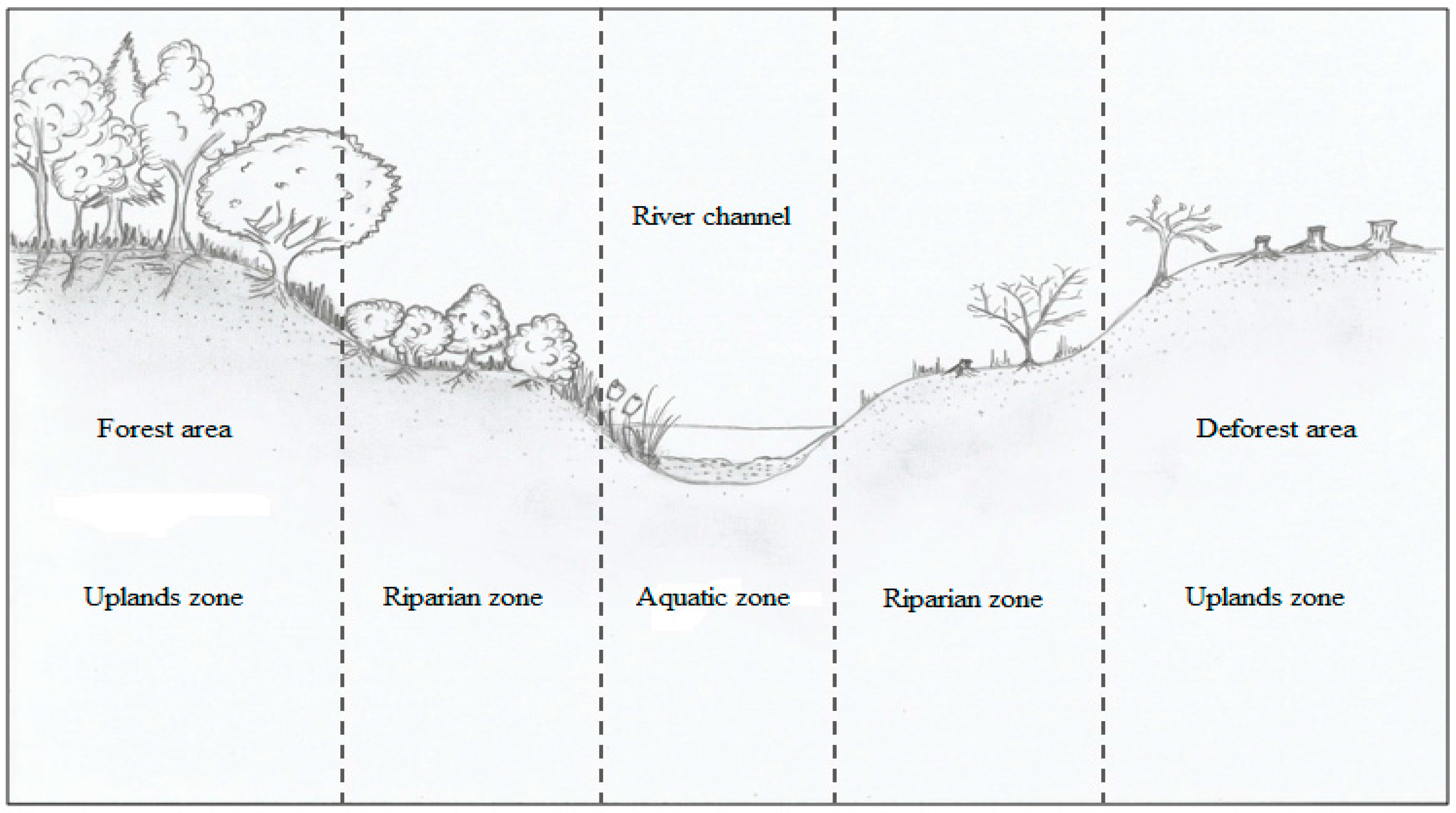
8. Impact of Land Clearing Activities on the Watersheds
8.1. Deforestation Activities
8.2. Agriculture Activities
8.3. Mining Activities
8.4. Urban and Rural Residential
9. Erosion Mitigation
9.1. Natural Erosion Mitigation
9.2. Infrastructures
10. Conclusions
Acknowledgments
Conflicts of Interest
References
- Pan, Y.; Birdsey, R.A.; Phillips, O.L.; Jackson, R.B. The structure, distribution, and biomass of the world’s forests. Annu. Rev. Ecol. Evol. Syst. 2013, 44, 593–622. [Google Scholar] [CrossRef]
- Food and Agriculture Organization (FAO). Statistical Pocketbook 2015 World Food and Agriculture. 2015. Available online: http://www.fao.org/3/a-i4691e.pdf (accessed on 17 March 2017).
- Nasi, R.; Wunder, S.; Campos, J.J. Forest Ecosystem Services: Can They Pay Our Way out of Deforestation? CIFOR for the Global Environmental Facility (GEF): Bogor, Indonesia, 2002; p. 37. [Google Scholar]
- Millennium Ecosystem Assessment (MEA). Millennium Ecosystem Assessment: Ecosystem and Human Well Being: Synthesis; Island Press: Washington, DC, USA, 2005. [Google Scholar]
- Furniss, M.J.; Staab, B.P.; Hazelhurst, S.; Clifton, C.F.; Kenneth, R.B.; Ilhadrt, B.L.; Elizabeth, B.; Todd, A.H.; Reid, L.M.; Hines, S.J.; et al. Water, Climate Change, and Forests: Watershed Stewardship for a Changing Climate; Gen. Tech. Rep. PNW-GTR-812; U.S. Department of Agriculture, Forest Service, Pacific Northwest Research Station: Portland, OR, USA, 2010; p. 75.
- De Bello, F.; Lavorel, S.; Díaz, S.; Harrington, R.; Cornelissen, J.H.; Bardgett, R.D.; Berg, M.P.; Cipriotti, P.; Feld, C.K.; Hering, D.; et al. Towards an assessment of multiple ecosystem processes and services via functional traits. Biodivers. Conserv. 2010, 19, 2873–2893. [Google Scholar] [CrossRef]
- Fisher, R.F.; Binkley, D. Ecology and Management of Forest Soils: Forest Soil and Vegetation Development, 3rd ed.; John Wiley & Sons, Inc.: New York, NY, USA, 2012; pp. 11–15. [Google Scholar]
- Sing, L.; Ray, D.; Watts, K. Forestry Commission. Ecosyst. Serv. For. Manag. 2015. Available online: http://www.otago.ac.nz/library/pdf/harvard_citing_and_referencing_guide_2007.pdf (accessed on 28 February 2017).
- De Groot, R.S.; Wilson, M.A.; Boumans, R.M.J. A typology for the classification, description and valuation of ecosystem functions, goods and services. Ecol. Econ. 2002, 41, 393–408. [Google Scholar] [CrossRef]
- Sweeney, B.W.; Newbold, J.D. Streamside forest buffer width needed to protect stream water quality, habitat, and organisms: A literature review. J. Am. Water Resour. Assoc. 2014, 50, 560–584. [Google Scholar] [CrossRef]
- US Environmental Protection Agency (EPA). Achieving Cleaner Waters across America: Supporting Effective Programs to Prevent Water Pollution from Forestry Operations; EPA841-F-002; US Environmental Protection Agency: Washington, DC, USA, 2000.
- Kreye, M.M.; Adams, D.C.; Escobedo, F.J. The value of forest conservation for water quality protection. Forests 2014, 5, 862–884. [Google Scholar] [CrossRef]
- Chichilnisky, G.; Heal, G. Economic returns from the biosphere. Nat. Lond. 1998, 391, 629–630. [Google Scholar] [CrossRef]
- Ernst, C.; Gullick, R.; Nixon, K. Conserving forests to protect water. Am. Water W. Assoc. 2004, 30, 1–7. [Google Scholar]
- Landsberg, J.; Waring, R. Forest Types around the World. In Forests in Our Changing World; Island Press/Center for Resource Economics: Washington, DC, USA, 2014; pp. 21–46. [Google Scholar]
- Mahapatra, K.; Kant, S. Tropical Deforestation: A Multinomial Logistic Model and some Country-specific Policy Prescriptions. J. For. Policy Econ. 2003, 7, 1–8. [Google Scholar] [CrossRef]
- Nelson, E.J.; Kareiva, P.; Ruckelshaus, M.; Arkema, K.; Geller, G.; Girvetz, E.; Goodrich, D.; Matzek, V.; Pinsky, M.; Reid, W.; et al. Climate change impact on key ecosystem services and the human well-being they support in the US. Front. Ecol. Environ. 2013, 11, 483–893. [Google Scholar] [CrossRef]
- Göncü, S.; Albek, E. Modeling the effects of climate change on different land uses. Water Sci. Technol. 2007, 56, 131–138. [Google Scholar] [CrossRef] [PubMed]
- López, S.; Wright, C.; Costanza, P. Environmental change in the equatorial Andes: Linking climate, land use, and land cover transformations. Remote Sens. Appl. Soc. Environ. 2016. [Google Scholar] [CrossRef]
- Trenberth, K.E. Changes in precipitation with climate change. Clim. Res. 2011, 47, 123–138. [Google Scholar] [CrossRef]
- Loo, Y.Y.; Billa, L.; Singh, A. Effect of climate change on seasonal monsoon in Asia and its impact on the variability of monsoon rainfall in Southeast Asia. Geosci. Front. 2015, 6, 817–823. [Google Scholar] [CrossRef]
- Turner, A. The Indian Monsoon in a Changing Climate. 2013. Available online: https://www.rmets.org/weather-and-climate/climate/indian-monsoon-changing-climate (accessed on 9 March 2017).
- Zimmermann, F. Monsoon in Traditional Culture (South Asia); National Science Foundation, A Wiley-Interscience Publication of John Wiley & Sons: New York, NY, USA, 1987; pp. 51–76. [Google Scholar]
- Slingo, J. Dynamical Theory ENSO—Monsoon Interactions Prediction. 2003. Available online: http://curry.eas.gatech.edu/Courses/6140/ency/Chapter12/Ency_Atmos/Monsoon_Overview.pdf (accessed on 9 March 2017).
- Wang, B.; Ding, Q.; Joseph, P.V. Objective Definition of the Indian Summer Monsoon Onset. J. Clim. 2009, 22, 3303–3316. [Google Scholar] [CrossRef]
- Levermann, A.; Schewe, J.; Petoukhov, V.; Held, H. Basic mechanism for abrupt monsoon transitions. Proc. Natl. Acad. Sci. USA 2009, 106, 20572–20577. [Google Scholar] [CrossRef] [PubMed]
- Kelly, P.; Mapes, B. Land surface heating and the North American monsoon anticyclone: Model evaluation from diurnal to seasonal. J. Clim. 2010, 23, 4096–4106. [Google Scholar] [CrossRef]
- Chand, R.; Raju, S.S. Dealing with Effects of Monsoon Failures. Economic and Political Weekly. 10 October 2009. Available online: http://0-www-epw-in.brum.beds.ac.uk/journal/2009/41-42/perspectives/dealing-effects-monsoon-failures.html (accessed on 19 March 2017).
- Rahmatullah, M. Synoptic aspects of the monsoon circulation and rainfall over Indo-Pakistan. J. Meteorol. 1952, 9, 176–179. [Google Scholar] [CrossRef]
- Earth Observatory. The Intertropical Convergence Zone. 2000. Available online: http://earthobservatory.nasa.gov/IOTD/view.php?id=703 (accessed on 16 June 2016).
- Fleitmann, D.; Burns, S.J.; Mangini, A.; Mudelsee, M.; Kramers, J.; Villa, I.; Neff, U.; Al-Subbary, A.A.; Buettner, A.; Hippler, D.; et al. Holocene ITCZ and Indian monsoon dynamics recorded in stalagmites from Oman and Yemen (Socotra). Quat. Sci. Rev. 2007, 26, 170–188. [Google Scholar] [CrossRef]
- An, Z.S.; Porter, S.C.; Kutzbach, J.E.; Wu, X.H.; Wang, S.M.; Liu, X.D.; Li, X.Q.; Zhou, W.J. Asynchronous Holocene optimum of the East Asian monsoon. Quat. Sci. Rev. 2000, 19, 743–762. [Google Scholar] [CrossRef]
- Gasse, F. Hydrological changes in the African tropics since the Last Glacial Maximum. Quat. Sci. Rev. 2000, 19, 189–211. [Google Scholar] [CrossRef]
- Wang, Y.J.; Cheng, H.; Edwards, R.L.; He, Y.Q.; Kong, X.G.; An, Z.S.; Wu, J.Y.; Kelly, M.J.; Dykoski, C.A.; Li, X.D. The Holocene Asian monsoon: Links to solar changes and North Atlantic climate. Science 2005, 308, 854–857. [Google Scholar] [CrossRef] [PubMed]
- Ludwig, H.F.; Browder, G. Appropriate water supply and sanitation technology for developing countries in tropical monsoon climates. Environmentalist 1992, 12, 131–139. [Google Scholar] [CrossRef]
- Soman, M.K.; Slingo, J. Sensitivity of the Asian summer monsoon to aspects of sea-surface-temperature anomalies in the tropical Pacific Ocean. Q. J. R. Meteorol. Soc. 1997, 123, 309–336. [Google Scholar]
- Li, T.; Zhang, Y.; Chang, C.P.; Wang, B. On the relationship between Indian Ocean sea surface temperature and Asian summer monsoon. Geophys. Res. Lett. 2001, 28, 2843–2846. [Google Scholar] [CrossRef]
- Anderson, D.M.; Overpeck, J.T.; Gupta, A.K. Increase in the Asian southwest monsoon during the past four centuries. Science 2002, 297, 596–599. [Google Scholar] [CrossRef] [PubMed]
- The Globe Program. 2011. Available online: https://www.globe.gov/web/globescientist/blog/-/blogs/what-exactly-is-the-monsoon- (accessed on 23 March 2017).
- Drinkwater, M.; Kerr, Y.; Font, J.; Berger, M. Water Cycle of The ‘Blue Planet’. 2009. Available online: https://www.researchgate.net/profile/Michael_Berger10/publication/262124721_Exploring_the_Water_Cycle_of_the_Blue_Planet_The_Soil_Moisture_and_Ocean_Salinity_SMOS_mission/links/00b7d536b78c253080000000.pdf (accessed on 9 March 2017).
- Trewin, B. The climates of the Tropics and how they are changing. State Trop. 2014. Available online: http://stateofthetropics.org/wp-content/uploads/Essay-1-Trewin.pdf (accssed on 30 March 2017).
- De Jong, C. The contribution of condensation to the water cycle under high-mountain conditions. Hydrol. Processes 2005, 19, 2419–2435. [Google Scholar] [CrossRef]
- National Weather Service. The Water Cycle. 2010. Available online: http://www.srh.weather.gov/srh/jetstream/downloads/hydro2010.pdf (accessed on 19 September 2016).
- Gerrits, A.M.J. The Role of Interception in the Hydrological Cycle. Ph.D. Thesis, TU Delft, Delft University of Technology, Delft, The Netherlands, June 2010. [Google Scholar]
- Kuchment, L.S. The hydrological cycle and human impact on it. Water Resour. Manag. 2004. Available online: http://www.eolss.net/ebooks/Sample%20Chapters/C07/E2-16-10-01.pdf (accesed on 9 March 2017).
- National Oceanic and Atmospheric Administration. Water Cycle. 2015. Available online: http://www.noaa.gov/resource-collections/water-cycle (accessed on 25 January 2017).
- Brown, P. Basics of Evaporation and Evapotranspiration. 2014. Available online: https://extension.arizona.edu/sites/extension.arizona.edu/files/pubs/az1194.pdf (accessed on 9 March 2017).
- Center for Watershed Protection (CWP). Watershed Forestry Resource Guide. 2008. Available online: http://forestsforwatersheds.org/forests-and-drinking-water/ (accessed on 27 June 2016).
- Neary, D.G.; Ice, G.G.; Jackson, C.R. Linkages between forest soils and water quality and quantity. For. Ecol. Manag. 2009, 258, 2269–2281. [Google Scholar] [CrossRef]
- Rosenow, J. Trees Play Key Role in Purifying Our Water. 2010. Available online: http://www.ajc.com/news/news/opinion/trees-play-key-role-in-purifying-our-water/nQfd7/ (accessed on 27 June 2016).
- Vincent, J.R.; Ahmad, I.; Adnan, N.; Burwell, W.B., III; Pattanayak, S.K.; Tan-Soo, J.S.; Thomas, K. Valuing water purification by forests: An analysis of Malaysian panel data. Environ. Resour. Econ. 2016, 64, 59–80. [Google Scholar] [CrossRef]
- Brumark. Total Flooring Solutions. An Exploring.com, Inc. Company. 2008. Available online: http://www.brumark.com/Sustainable2/sustainableflooring-impactdeforest.html (accessed on 30 June 2016).
- Edwards, P.J.; Williard, K.W.; Schoonover, J.E. Fundamentals of watershed hydrology. J. Contemp. Water Res. Educ. 2015, 154, 3–20. [Google Scholar] [CrossRef]
- Swenson, S.; Wahr, J. Estimating large-scale precipitation minus evapotranspiration from GRACE satellite gravity measurements. J. Hydrometeorol. 2006, 7, 252–270. [Google Scholar] [CrossRef]
- Carlifornia Academy of Science. Amazon Water Cycle Role-Play. 2015. Available online: http://www.calacademy.org:8080/sites/default/files/assets/docs/pdf/partsofthewatercycletable.pdf (accessed on 20 September 2016).
- Bradford, A. Deforestation: Facts, Causes & Effects. Live Science Contributor, 2015. Available online: http://www.livescience.com/27692-deforestation.html (accessed on 7 September 2016).
- Kory. The Water Cycle: From Evaporation to Precipitation. 2012. Available online: http://www.filtersfast.com/blog/index.php/2012/03/the-water-cyclefromevaporation-to-precipitation/ (accessed on 20 September 2016).
- Small, M. Plant Growth Factors: Photosynthesis, Respiration, and Transpiration; Colorado State University Extension, 2016; Available online: http://www.ext.colostate.edu/mg/gardennotes/141.html (accessed on July 2016).
- Lackner, K.S.; Grimes, P.; Ziock, H.J. Capturing Carbon Dioxide from Air. 2001. Available online: https://www.netl.doe.gov/publications/proceedings/01/carbon_seq/7b1.pdf (accessed on 9 March 2017).
- Mary, B.; Recous, S.; Darwis, D.; Robin, D. Interactions between decomposition of plant residues and nitrogen cycling in soil. Plant Soil 1996, 181, 71–82. [Google Scholar] [CrossRef]
- Ghaly, A.E.; Ramakrishnan, V.V. Nitrogen sources and cycling in the ecosystem and its role in air, water and soil pollution: A critical review. J. Pollut. Eff. Control 2015, 3, 126. [Google Scholar]
- Van Groenigen, J.W.; Huygens, D.; Boeckx, P.; Kuyper, T.W.; Lubbers, I.M.; Rütting, T.; Groffman, P.M. The soil N cycle: New insights and key challenges. Soil 2015, 1, 235. [Google Scholar] [CrossRef]
- Butler, R. Climatic Role of Forests. 2012. Available online: http://rainforests.mongabay.com/0906.htm (accessed on 27 June 2016).
- Douglas, J.K. Economic Value of Forest Ecosystem Services: A Review. Wilderness Soc. 2001. Available online: https://www.sierraforestlegacy.org/Resources/Conservation/FireForestEcology/ForestEconomics/EcosystemServices.pdf (accessed on 9 March 2017).
- Aragão, L. The rainforest’s water pump. Nature 2012, 489, 217–218. [Google Scholar] [PubMed]
- Werth, D.; Avissar, R. The local and global effects of African deforestation. Geophys. Res. Lett. 2005, 32, L12704. [Google Scholar] [CrossRef]
- Charney, J.; Quirk, W.; Chow, S.-H.; Kornfield, J. A comparative study of the effects of albedo change on drought in semi-arid regions. J. Atmos. Sci. 1977, 34, 1366–1385. [Google Scholar] [CrossRef]
- Werth, D.; Avissar, R. The regional evapotranspiration of the Amazon. J. Hydrometeorol. 2004, 5, 100–109. [Google Scholar] [CrossRef]
- Cao, L.; Bala, G.; Caldeira, K.; Nemani, R.; Ban-Weiss, G. Importance of carbon dioxide physiological forcing to future climate change. Proc. Natl. Acad. Sci. USA 2010, 107, 9513–9518. [Google Scholar] [CrossRef] [PubMed]
- Schiermeier, Q. Increased flood risk linked to global warming: Likelihood of extreme rainfall may have been doubled by rising greenhouse-gas levels. Nature 2011, 470, 316–317. [Google Scholar] [CrossRef] [PubMed]
- Miller, C.; Cotter, J. An Impending Storm: Impacts of Deforestation on Weather Patterns and Agriculture; Greenpeace Research Laboratories, 2013; Available online: http://www.greenpeace.org/international/Global/international/publications/forests/2013/JN455-An-Impending-Storm.pdf (accessed on 30 March 2017).
- Spracklen, D.V.; Arnold, S.R.; Taylor, C.M. Observations of increased tropical rainfall preceded by air passage over forests. Nature 2012, 489, 282–285. [Google Scholar] [CrossRef] [PubMed]
- Wilkie, D.S.; Trexler, M.C. Biogeophysical setting and global climate change. In Central Africa: Global Climate Change and Development; Technical Report; Biodiversity Support Program: Washington DC, WA, USA, 1993. [Google Scholar]
- Chomitz, K.M.; Kumari, K. The Domestic Benefits of Tropical Forests: A Critical Review Emphasizing Hydrological Functions; World Bank Policy Research Working Paper; World Bank Group: Washington, DC, USA, 1998; pp. 13–35. [Google Scholar]
- Ishak, M.I.S. A Reconnaissance Study of Water and Carbon Fluxes in Tropical Watersheds of Peninsular Malaysia: Stable Isotope Constraints. Ph.D. Dissertation, University of Ottawa, Ottawa, ON, Canada, 2014. [Google Scholar]
- Baede, A.P.M.; Ahlonsou, E.; Ding, Y.; Schimel, D.; Bolin, B.; Pollonais, S. The Climate System: An Overview; Climate Change; Cambridge University Press: New York, NY, USA, 2001; pp. 87–98. [Google Scholar]
- Chahine, M.T. The Hydrological Cycle and its Influence on Climate. Nature 1992, 359, 373–380. [Google Scholar] [CrossRef]
- Donaldson, S. The Effects of Urbanization on the Water Cycle; University of Nevada Cooperative Extension, 2004; Available online: https://www.unce.unr.edu/publications/files/nr/2004/FS0443.pdf (accessed on 9 March 2017).
- Randhir, T.O.; Hawes, A.G. Ecology and Poverty in Watershed Management. In Integrating Ecology and Poverty Reduction; Springer: New York, NY, USA, 2012; pp. 113–126. [Google Scholar]
- Monsoon Season. An Introduction to the Monsoon Season and Its Effects. 2009. Available online: http://monsoonseason.com/ (accessed on 17 June 2016).
- Wing, C.C. Managing Flood Problems in Malaysia. Buletin Ingeniur, 1971. Available online: http://www.bem.org.my/publication/juneaug04/F(Flood)(38-43).pdf (accessed on 10 March 2017).
- Hua, A.K. Monsoon Flood Disaster in Kota Bharu, Kelantan Case Study: A Comprehensive Review. Int. J. Sci. Eng. Res. 2014, 3, 79–81. [Google Scholar]
- Nepal Earthquake Assessment Unit. Landslides and Flash Floods in the Monsoon. 2015. Available online: https://www.humanitarianresponse.info/en/system/files/documents/files/150623_monsoon_hazard_analysis_final_.pdf (accessed on 17 June 2016).
- EM-DAT: The International Disaster Database. Disaster List. 2017. Available online: http://www.emdat.be/disaster_list/index.html (accessed on 25 January 2017).
- Forestry Commission. Can Forestry Reduce Flooding? 2004. Available online: http://www.forestry.gov.uk/fr/infd-6mvecj (accessed on 17 June 2016).
- Forestry Commission. Flood Risk Alleviation. 2006. Available online: http://www.forestry.gov.uk/fr/urgc-7qjdh7 (accessed on 17 June 2016).
- Deni, S.M.; Suhaila, J.; Zin, W.Z.W.; Jemain, A.A. Trends of wet spells over Peninsular Malaysia during monsoon seasons. Sains Malays. 2009, 38, 133–142. [Google Scholar]
- Suhaila, J.; Deni, S.M.; Zin, W.Z.W.; Jemain, A.A. Trends in Peninsular Malaysia rainfall data during the southwest monsoon and northeast monsoons seasons: 1975–2004. Sains Malays. 2010, 39, 533–542. [Google Scholar]
- Akasah, Z.A.; Doraisamy, S.V. Malaysia flood: Impacts & factors contributing towards the restoration of damages. J. Sci. Res. Dev. 2015, 2, 53–59. [Google Scholar]
- Khan, M.M.A.; Shaari, N.A.B.; Bahar, A.M.A.; Baten, M.A.; Nazaruddin, D.A.B. Flood impact assessment in Kota Bharu, Malaysia: A statistical analysis. World Appl. Sci. J. 2014, 32, 626–634. [Google Scholar]
- Islam, R.; Kamaruddin, R.; Ahmad, S.A.; Jan, S.J.; Anuar, A.R. A Review on Mechanism of Flood Disaster Management in Asia. Int. Rev. Manag. Market. 2016, 6, 29–52. [Google Scholar]
- Basher, L.R. Erosion processes and their control in New Zealand. Ecosyst. Serv. N. Z. Cond. Trends 2013, 2013, 363–374. Available online: https://www.landcareresearch.co.nz/__data/assets/pdf_file/0004/77053/2_7_Basher.pdf (accessed on 10 March 2017).
- Gashaw, T.; Bantider, A.; Silassie, H.G. Land Degradation in Ethiopia: Causes, Impacts and Rehabilitation Techniques; Department of Natural Resource Management, Adigrat University: Adigrat, Ethiopia, 2014. [Google Scholar]
- Extence, C.A.; Chadd, R.P.; England, J.; Dunbar, M.J.; Wood, P.J.; Taylor, E.D. The Assessment of Fine Sediment Accumulation in Rivers Using Macro-Invertebrate Community Response. River Res. Appl. 2013, 29, 17–55. [Google Scholar] [CrossRef]
- Nelson, S.A. Natural Disaster. River Systems & Causes of Flooding. EENS 3050. 2012. Available online: http://www.tulane.edu/~sanelson/Natural_Disasters/riversystems.htm (accessed on 7 September 2016).
- Food and Agriculture Organization (FAO). Global Forest Resources Assessments. 2006. Available online: http://www.fao.org/forest-resources-assessment/en/ (accessed on 26 January 2017).
- Nojarov, P. 2005 Assessment of the flood risk and its contemporary tendencies on the basis of mean monthly precipitation in some regions of Bulgaria. In Proceedings of the First National Research Conference on Emergency Management and Protection of the Population, Sofia, Bulgaria, November 2005; pp. 157–163. [Google Scholar]
- Basak, S.R.; Basak, A.C.; Rahman, M.A. Impacts of floods on forest trees and their coping strategies in Bangladesh. Weather Clim. Extremes 2015, 7, 43–48. [Google Scholar] [CrossRef]
- Iacob, O.; Rowan, J.; Brown, I.; Ellis, C. Natural flood management as a climate change adaptation option assessed using an ecosystem services approach. In Hydrology for a Changing World, Proceedings of 11th BHS National Symposium, Dundee, Scotland, 9–11 July 2012; British Hydrological Society: London, UK, 2012. [Google Scholar]
- Martin, S.L.; Ballance, L.T.; Groves, T. An Ecosystem Services Perspective for the Oceanic Eastern Tropical Pacific: Commercial Fisheries, Carbon Storage, Recreational Fishing, and Biodiversity. Front. Mar. Sci. 2016, 3, 50. [Google Scholar] [CrossRef]
- Hamel, P.; Bryant, B.P. Uncertainty assessment in ecosystem services analyses: Seven challenges and practical responses. Ecosyst. Serv. 2017, 24, 1–15. [Google Scholar] [CrossRef]
- Richardsa, D.R.; Warrena, P.H.; Maltbya, L.; Moggridgeb, H.L. Awareness of greater numbers of ecosystem services affects preferences for floodplain management. Ecosyst. Serv. 2017, 24, 138–146. [Google Scholar] [CrossRef]
- Ferwerda, W. Nature Resilience: Ecological Restoration by Partners in Business for the Next Generations; Rotterdam School of Management, Erasmus University: Rotterdam, The Netherlands, 2012. [Google Scholar]
- Calder, I.; Hofer, T.; Vermont, S.; Warren, P. Towards a new understanding of forests and water. Unasylva 2007, 58, 3–10. [Google Scholar]
- Elliot, W.J.; Page-Dumroese, D.; Robichaud, P.R. The Effects of Forest Management on Erosion and Soil Productivity. 1996. Available online: https://forest.moscowfsl.wsu.edu/engr/library/Elliot/Elliot1996c/1996c.pdf (accessed on 10 March 2017).
- Holden, J.; Gascoign, M.; Bosanko, N.R. Erosion and natural revegetation associated with surface land drains in upland peatlands. Earth Surf. Processes Land. 2007, 32, 1547–1557. [Google Scholar]
- Rapp, A. Soil erosion and sedimentation in Tanzania and Lesotho. Ambio 1975, 4, 154–163. [Google Scholar]
- Vitousek, P.M.; Bolin, B.; Crutzen, P.J.; Woodmansee, R.G.; Goldberg, E.D.; Cook, R.B. SCOPE 21—The Major Biogeochemical Cycles and Their Interactions. In Proceedings of the Workshop on the Interaction of Biogeochemical Cycles, Örsundsbro, Sweden, 25–31 May 1981; Volume 25, p. 30. [Google Scholar]
- Sparovek, G.; Van Lier, Q.J. Definition of tolerable soil erosion values. Revista Brasileira de Ciência do Solo 1997, 21, 467–471. [Google Scholar] [CrossRef]
- Grimm, M.; Jones, R.J.; Rusco, E.; Montanarella, L. Soil Erosion Risk in Italy: A Revised USLE Approach; European Soil Bureau Research Report; Office for Official Publications of the European Communities: Luxembourg, 2003; p. 23. [Google Scholar]
- Thiemann, S.; Schütt, B.; Förch, G. Assessment of Erosion and Soil Erosion Processes—A Case Study from the Northern Ethiopian Highland. FWU Water Resour. Publ. 2005, 3, 173–185. [Google Scholar]
- McConkey, B.G.; Lobb, D.A.; Li, S.; Black, J.M.W.; Krug, P.M. Soil Erosion on Cropland: Introduction and Trends for Canada; Canadian Biodiversity: Ecosystem Status and Trends; Canadian Councils of Resource Ministers: Toronto, ON, Canada, 2012. [Google Scholar]
- Peter, F.F.; Kenneth, N.B.; Roberto, P.T.; Pablo, G.C.; Daniel, G.N. Soil Erosion and Sediment Production on Watershed Landscapes: Processes, Prevention, and Control; UNESCO: Monteviedo, Uruguay, 2013. [Google Scholar]
- Warren, J. Raindrops and Bombs: The Erosion Process. Soil and Water Conservation Extension Specialist; Oklahoma State University, 1964. Available online: http://pods.dasnr.okstate.edu/docushare/dsweb/Get/Document-2217/F-2252web.pdf (accessed on 10 March 2017).
- Wright, S.A.; Schoellhamer, D.H. Trends in the sediment yield of the Sacramento River, California, 1957–2001. San Franc. Estuary Watershed Sci. 2004, 2, 3. [Google Scholar]
- Fred, T.M.; Judith, A.M. Our Changing Planet. An Introduction to Earth System Science and Global Environmental Change; Prentice-Hall: Honolulu, HI, USA, 1995. [Google Scholar]
- Soil Web. SoilWeb/Soil Management/Soil Erosion; The University of British Columbia, 2003. Available online: http://wiki.ubc.ca/LFS:SoilWeb/Soil_Management/Soil_Erosion (accessed on 23 May 2016).
- Chapman, D.V. (Ed.) Water Quality Assessments: A Guide to the Use of Biota, Sediments, and Water in Environmental Monitoring; E&FN Spon, an Imprint of Chapman & Hall: London, UK, 1992. [Google Scholar]
- Kithiia, S.M. Effects of Sediments Loads on Water Quality within the Nairobi River Basins, Kenya. 2012. Available online: http://www.ij-ep.org/paperInfo.aspx?ID=85 (accessed on 10 March 2017).
- Ling, T.Y.; Soo, C.L.; Sivalingam, J.R.; Nyanti, L.; Sim, S.F.; Grinang, J. Assessment of the Water and Sediment Quality of Tropical Forest Streams in Upper Reaches of the Baleh River, Sarawak, Malaysia, Subjected to Logging Activities. J. Chem. 2016, 2016, 8503931. [Google Scholar] [CrossRef]
- Bell, R.; Green, M.; Hume, T.; Gorman, R. What regulates sedimentation in estuaries. Water Atmos. 2000, 8, 13–16. [Google Scholar]
- Nokes, C. The Effect of Sediment on Water Quality; The University of Waikato, 2008; Available online: http://sciencelearn.org.nz/Contexts/Enviro-imprints/Sci-Media/Video/The-effect-of-sediment-on-water-quality (accessed on 7 September 2016).
- Pearce, D.; Brown, K. Saving the world’s tropical forests. In The Causes of Tropical of Tropical Deforestation. The Economic and Statistical Analysis of Factors Giving Rise to the Loss of the Tropical Forest; Brown, K., Pearce, D., Eds.; UBC Press: Toronto, ON, Canada, 1994; pp. 2–26. [Google Scholar]
- Van Kooten, G.C.; Bulte, E.H. The Economics of Nature: Managing Biological Assets; Blackwell’s: Oxford, UK, 2000; p. 512. [Google Scholar]
- Glade, T. Landslide occurrence as a response to land use change: A review of evidence from New Zealand. Catena 2003, 51, 297–314. [Google Scholar] [CrossRef]
- McWethy, D.B.; Whitlock, C.; Wilmshurst, J.M.; McGlone, M.S.; Li, X. Rapid deforestation of south island, New Zealand, by early Polynesian fires. Holocene 2009, 19, 883–897. [Google Scholar] [CrossRef]
- Wijitkosum, S. Impacts of land use changes on soil erosion in Pa Deng sub-district, adjacent area of Kaeng Krachan National Park, Thailand. Soil Water Res. 2012, 7, 10–17. [Google Scholar]
- Ansa-Asare, O.D.; Asante, K.A. The water quality of Birim river in South-East Ghana. West Afr. J. Appl. Ecol. 2000, 1, 23–34. [Google Scholar] [CrossRef]
- Fearnside, P.M. Deforestation in the Brazilian Amazon: How fast is it occurring? Interciencia 1982, 7, 82–88. [Google Scholar]
- Koh, L.P.; Wilcove, D.S. Is oil palm agriculture destroying tropical biodiversity? Conserv. Lett. 2008, 1, 60–64. [Google Scholar] [CrossRef]
- Summary of the State of Johor’s Forest Management Plan for the Period between 2006–2015; Forestry Department of Malaysia: Kuala Lumpur, 2006; p. 71.
- Malaysian Palm Oil Board. Economics and Industry Development Division. 2012. Available online: http://bepi.mpob.gov.my/ (accessed on 2 December 2016).
- Fearnside, P.M. A floresta vai acabar? Ciencia Hoje 1984, 2, 42–52. [Google Scholar]
- Looney, J.W. Land degradation in Australia: The search for a legal remedy. J. Soil Water Conserv. 1991, 46, 256–259. [Google Scholar]
- Squelch, J. Land clearing laws in Western Australia. Legal Issues in Bus. 2007, 9, 72. [Google Scholar]
- Langdale, G.W.; Blevins, R.L.; Karlen, D.L.; McCool, D.K.; Nearing, M.A.; Skidmore, E.L.; Thomas, A.W.; Tyler, D.D.; Williams, J.R. Wind and Water Erosion. Cover Crop Effects on Soil Erosion by Wind and Water; Soil and Water Conserv. Soc.: Ankeny, IA, USA, 1991; pp. 15–22. [Google Scholar]
- Panagos, P.; Borrelli, P.; Meusburger, K.; Alewell, C.; Lugato, E.; Montanarella, L. Estimating the soil erosion cover-management factor at the European scale. Land Use Policy 2015, 48, 38–50. [Google Scholar] [CrossRef]
- Dorren, L.; Rey, F. A review of the effect of terracing on erosion. In Briefing Papers of the 2nd SCAPE Workshop; Scape: Cinque Terre, Italy, 2004; pp. 97–108. [Google Scholar]
- Gallart, F.; Llorens, P.; Latron, J. Studying the role of old agricultural terraces on runoff generation in a small Mediterranean mountainous basin. J. Hydrol. 1994, 159, 291–303. [Google Scholar] [CrossRef]
- Lasanta, T.; Arnaez, J.; Oserin, M.; Ortigosa, L.M. Marginal lands and erosion in terraced fields in the Mediterranean mountains. Mt. Res. Dev. 2001, 21, 69–76. [Google Scholar] [CrossRef]
- Sluiter, R.; de Jong, S.M. Spatial patterns of Mediterranean land abandonment and related land cover transitions. Landsc. Ecol. 2007, 22, 559–576. [Google Scholar] [CrossRef]
- Tarolli, P.; Preti, F.; Romano, N. Terraced landscapes: From an old best practice to a potential hazard for soil degradation due to land abandonment. Anthropocene 2014, 6, 10–25. [Google Scholar] [CrossRef]
- Koulouri, M.; Giourga, C. Land abandonment and slope gradient as key factors of soil erosion in Mediterranean terraced lands. Catena 2007, 69, 274–281. [Google Scholar] [CrossRef]
- Dunjó, G.; Pardini, G.; Gispert, M. Land use change effects on abandoned terraced soils in a Mediterranean catchment, NE Spain. Catena 2003, 52, 23–37. [Google Scholar] [CrossRef]
- Gardner, R.A.M.; Gerrard, A.J. Runoff and soil erosion on cultivated rainfed terraces in the Middle Hills of Nepal. Appl. Geogr. 2003, 23, 23–45. [Google Scholar] [CrossRef]
- Hammad, A.H.A.; Børresen, T.; Haugen, L.E. Effects of rain characteristics and terracing on runoff and erosion under the Mediterranean. Soil Tillage Res. 2006, 87, 39–47. [Google Scholar]
- Sidle, R.C.; Ziegler, A.D.; Negishi, J.N.; Nik, A.R.; Siew, R.; Turkelboom, F. Erosion processes in steep terrain—truths, myths, and uncertainties related to forest management in Southeast Asia. For. Ecol. Manag. 2006, 224, 199–225. [Google Scholar] [CrossRef]
- Bazzoffi, P.; Gardin, L. Effectiveness of the GAEC standard of cross compliance retain terraces on soil erosion control. Ital. J. Agron. 2011, 6, 6. [Google Scholar] [CrossRef]
- Cammeraat, E.L. Scale dependent thresholds in hydrological and erosion response of a semi-arid catchment in southeast Spain. Agric. Ecosyst. Environ. 2004, 104, 317–332. [Google Scholar]
- Cots-Folch, R.; Martínez-Casasnovas, J.A.; Ramos, M.C. Land terracing for new vineyard plantations in the north-eastern Spanish Mediterranean region: Landscape effects of the EU Council Regulation policy for vineyards’ restructuring. Agric. Ecosyst. Environ. 2006, 115, 88–96. [Google Scholar] [CrossRef]
- Yuan, T.; Fengmin, L.; Puhai, L. Economic analysis of rainwater harvesting and irrigation methods, with an example from China. Agric. Water Manag. 2003, 60, 217–226. [Google Scholar] [CrossRef]
- Wakindiki, I.I.C.; Ben-Hur, M. Indigenous soil and water conservation techniques: Effects on runoff, erosion, and crop yields under semi-arid conditions. Soil Res. 2002, 40, 367–379. [Google Scholar] [CrossRef]
- Louwagie, G.; Gay, S.H.; Sammeth, F.; Ratinger, T. The potential of European Union policies to address soil degradation in agriculture. Land Degrad. Dev. 2011, 22, 5–17. [Google Scholar] [CrossRef]
- Foster, G.R.; Highfill, R.E. Effect of terraces on soil loss: USLE P factor values for terraces. J. Soil Water Conserv. 1983, 38, 48–51. [Google Scholar]
- Borselli, L.; Torri, D.; Øygarden, L.; De Alba, S.; Martínez-Casasnovas, J.A.; Bazzoffi, P.; Jakab, G. Land levelling. In Soil erosion in Europe; Wiley: Hoboken, NJ, USA, 2006; pp. 643–658. [Google Scholar]
- Lesschen, J.P.; Schoorl, J.M.; Cammeraat, L.H. Modelling runoff and erosion for a semi-arid catchment using a multi-scale approach based on hydrological connectivity. Geomorphology 2009, 109, 174–183. [Google Scholar] [CrossRef]
- Dotterweich, M. The history of human-induced soil erosion: Geomorphic legacies, early descriptions and research, and the development of soil conservation—A global synopsis. Geomorphology 2013, 201, 1–34. [Google Scholar] [CrossRef]
- Lorsirirat, K.; Maita, H. Soil Erosion Problems in Northeast Thailand: A Case Study from the View of Agricultural Development in a Rural Community near Khon Kaen. Disaster Mitigation of Debris Flows, Slope Failures and Landslides; Universal Academy Press: Tokyo, Japan, 2006; pp. 675–686. [Google Scholar]
- Saisoong, C. Crop-livestock integration in North-East Thailand: Problems and prospects. In Grasslands and Forage Production in South-East Asia, Proceedings of the First Meeting of Regional Working Group on Grazing and Feed Resources of South-East Asia, Serdang, Malaysia, 27 February–3 March 1989; Halim, R.A., Ed.; University Pertanian Malaysia: Sergand, Malaysia, 1989; pp. 123–127. [Google Scholar]
- Ekasingh, B.; Sungkapitux, C.; Kitchaicharoen, J.; Suebpongsang, P. Competitive Commercial Agriculture in the Northeast of Thailand; The World Bank: Washington, DC, USA, 2007. [Google Scholar]
- Thongyou, M. Rubber cash crop and changes in livelihoods strategies in a village in Northeastern Thailand. Asian Soc. Sci. 2014, 10, 239. [Google Scholar] [CrossRef]
- Sthiannopkao, S.; Takizawa, S.; Wirojanagud, W. Effects of soil erosion on water quality and water uses in the upper Phong watershed. Water Sci. Technol. 2006, 53, 45–52. [Google Scholar] [CrossRef] [PubMed]
- Johannsen, S.S.; Armitage, P. Agricultural practice and the effects of agricultural land-use on water quality. Freshw. Forum 2010, 28, 45–59. [Google Scholar]
- Mulugeta, L. Effects of Land Use Change on Soil Quality and Native Flora Degradation and Restoration in the Highlands of Ethiopia. Implication for Sustainable Land Management; Swedish University of Agricultural Science: Uppsala, Sweden, 2004. [Google Scholar]
- Gebreyesus, B.; Kirubel, M. Estimating Soil Loss Using Universal Soil Loss Equation (USLE) for Soil Conservation planning at Medego Watershed, Northern Ethiopia. J. Am. Sci. 2009, 5, 58–69. [Google Scholar]
- Temesgen, G.; Amare, B.; Abraham, M. Population dynamics and land use/land cover changes in Dera District, Ethiopia. Glob. J. Biol. Agric. Health Sci. 2014, 3, 137–140. [Google Scholar]
- Saviour, N. Environmental impact of soil and sand mining: A review. Int. J. Sci. Environ. Technol. 2012, 1, 125–134. [Google Scholar]
- Sreebha, S.; Padmalal, D. Environmental impact assessment of sand mining from the small catchment rivers in the Southwestern Coast of India: A case study. Environ. Manag. 2011, 47, 130–140. [Google Scholar] [CrossRef] [PubMed]
- Mather, A.S. Global Forest Resources; International Book Distributors: Dehradun, India, 1991; p. 341. [Google Scholar]
- Sands, R. Forestry in a Global Context, 2nd ed.; CABI Publishing: Wallingford, UK, 2005; pp. 37–55. [Google Scholar]
- Wantzen, K.M.; Mol, J.H. Soil erosion from agriculture and mining: A threat to tropical stream ecosystems. Agriculture 2013, 3, 660–683. [Google Scholar] [CrossRef]
- Arun, P.R.; Sreeja, R.; Srecbha, S.; Maya, K.; Padmalal, D. River sand mining and its impact on physical and biological environments of Kerala Rivers, Southwest coast of India. Eco-Chronicle 2006, 1, l–6. [Google Scholar]
- Kitetu, J.; Rowan, J. Integrated environmental assessment applied to river sand harvesting in Kenya. In Sustainable Development in a Developing World—Integrated Socio-Economic Appraisal and Environmental Assessment; Patric, C.K., Lee, N., Eds.; Edward Elgar: Cheltenham, UK, 1997; pp. 189–199. [Google Scholar]
- Padmalal, D.; Maya, K.; Sreebha, S.; Sreeja, R. Environmental effects of river sand mining: A case from the river catchments of Vembanad lake, Southwest coast of India. Environ. Geol. 2008, 24, 879–889. [Google Scholar] [CrossRef]
- Ghose, M.K. Land reclamation and protection of environment from the effect of coal mining operation. Mine-tech 1989, 10, 35–39. [Google Scholar]
- Staff, S. Mining Deforestation nearly Tripled between 2000–08. 2010. Available online: http://www.stabroeknews.com/2010/archives/10/13/mining-deforestation-nearly-tripled-between-2000-08-%E2%80%93wwf/ (accessed on 25 November 2015).
- Docena, H. Philippines: Deforestation through Mining Subsidized by CDM Project. 2010. Available online: http://wrm.org.uy/oldsite/bulletin/161/Philippines.html (accessed on 25 November 2015).
- Anonymous. Mexico: Mining Causes Ecocide in Coahuayana, Michoacan. WRM’s, 2008. Available online: http://www.wrm.org.uy/oldsite/bulletin/136/Mexio.html (accessed on 24 November 2015).
- Griffiths, T.; Hirvelä, V.V. India: Illegal Aluminum Refinery in Tribal Lands in Orissa. 2008. Available online: http://wrm.org.uy/oldsite/bulletin/126/India.html (accessed on 25 November 2015).
- Weeks, J.R. Defining Urban Areas. 2010. Available online: https://geog.sdsu.edu/Research/Projects/IPC/publication/Weeks_Ch3.123.161 (accessed on 10 March 2017).
- Taylor, P.J.; Derudder, B. World City Network: A Global Urban Analysis; Psychology Press: Abingdon-on-Thames, UK, 2003; pp. 42–43. [Google Scholar]
- Gurnell, A.; Lee, M.; Souch, C. Urban rivers: Hydrology, geomorphology, ecology and opportunities for change. Geogr. Compass 2007, 1, 1118–1137. [Google Scholar] [CrossRef]
- Taotawin, N.; Taotawin, P. Crop booms and changing land use and land control in Thailand’s agricultural frontier. In Proceedings of the Conference on land grabbing, conclict and agrarian-environmental transformations: Perspectives from East and Southeast Asia, Chiang Mai, Thailand, 5–6 June 2015. [Google Scholar]
- Gregory, S.V.; Swanson, F.J.; McKee, W.A.; Cummins, K.W. An ecosystem perspective on riparian zones. Bioscience 1991, 41, 540–551. [Google Scholar] [CrossRef]
- Ilhardt, B.L.; Verry, E.S.; Palik, B.J. Defining riparian areas. In Riparian Management in Forests of the Continental Eastern United States; Lewis Publishers: New York, NY, USA, 2000; pp. 23–42. [Google Scholar]
- Rabeni, C.F.; Smale, M.A. Effects of siltation on stream fishes and the potential mitigating role of the buffering riparian zone. Hydrobiologia 1995, 303, 211–219. [Google Scholar] [CrossRef]
- Wu, H.; Soh, L.K.; Samal, A.; Hong, T.; Marx, D.; Chen, X. Upstream-Downstream Relationships in Terms of Annual Streamflow Discharges and Drought Events in Nebraska. J. Water Resour. Protect. 2009, 1, 299–315. [Google Scholar] [CrossRef]
- Williams, R.D.; Nicks, A.D. Using CREAMS to simulate filter strip effectiveness in erosion control. J. Soil Water Conserv. 1988, 43, 108–112. [Google Scholar]
- Wilkin, D.C.; Hebel, S.J. Erosion, redeposition and delivery of sediment to midwestern streams. Water. Resour. Res. 1982, 18, 1278–1282. [Google Scholar] [CrossRef]
- Allan, J.D. Landscapes and riverscapes: The influence of land use on stream ecosystems. Annu. Rev. Ecol. Evol. Syst. 2004, 35, 257–284. [Google Scholar] [CrossRef]
- Fernandes, J.D.F.; de Souza, A.L.; Tanaka, M.O. Can the structure of a riparian forest remnant influence stream water quality? A tropical case study. Hydrobiologia 2014, 724, 175–185. [Google Scholar] [CrossRef]
- Tanaka, M.O.; de Souza, A.L.T.; Moschini, L.E.; de Oliveira, A.K. Influence of watershed land use and riparian characteristics on biological indicators of stream water quality in southeastern Brazil. Agric. Ecosyst. Environ. 2016, 216, 333–339. [Google Scholar] [CrossRef]
- Nagy, R.; Porder, S.; Neill, C.; Brando, P.; Quintino, R.M.; Nascimento, S.A.D. Structure and composition of altered riparian forests in an agricultural Amazonian landscape. Ecol. Appl. 2015, 25, 1725–1738. [Google Scholar] [CrossRef] [PubMed]
- Osborne, L.L.; Kovacic, D.A. Riparian vegetated buffer strips in water-quality restoration and stream management. Freshw. Biol. 1993, 29, 243–258. [Google Scholar] [CrossRef]
- Tabacchi, E.; Correll, D.L.; Hauer, R.; Pinay, G.; Planty-Tabacchi, A.M.; Wissmar, R.C. Development, maintenance and role of riparian vegetation in the river landscape. Freshw. Biol. 1998, 40, 497–516. [Google Scholar] [CrossRef]
- Casatti, L.; Teresa, F.B.; Gonçalves-Souza, T.; Bessa, E.; Manzotti, A.R.; Gonçalves, C.D.S.; Zeni, J.D.O. From forests to cattail: How does the riparian zone influence stream fish? Neotrop. Ichthyol. 2012, 10, 205–214. [Google Scholar] [CrossRef]
- Jackson, C.R.; Leigh, D.S.; Scarbrough, S.L.; Chamblee, J.F. Herbaceous versus forested riparian vegetation: Narrow and simple versus wide, woody and diverse stream habitat. River Res. Appl. 2015, 31, 847–857. [Google Scholar] [CrossRef]
- De Paula, F.R.; de Barros Ferraz, S.F.; Gerhard, P.; Vettorazzi, C.A.; Ferreira, A. Large woody debris input and its influence on channel structure in agricultural lands of Southeast Brazil. Environ. Manag. 2011, 48, 750. [Google Scholar] [CrossRef] [PubMed]
- Collier, K.J.; Cooper, A.B.; Davies-Colley, R.J.; Rutherford, J.C.; Smith, C.M.; Williamson, R.B. Managing Riparian Zones. A Contribution to Protecting New Zealand’s Rivers and Streams; Department of Conservation: Wellington, New Zealand, 1995; p. 144.
- Sponseller, R.A.; Benfield, E.F.; Valett, H.M. Relationships between land use, spatial scale and stream macroinvertebrate communities. Freshw. Biol. 2001, 46, 1409–1424. [Google Scholar] [CrossRef]
- Naiman, R.J.; Decamps, H.; McClain, M.E. Riparia: Ecology, Conservation and Management of Streamside Communities; Elsevier: San Diego, CA, USA, 2005. [Google Scholar]
- Dosskey, M.G.; Vidon, P.; Gurwick, N.P.; Allan, C.J.; Duval, T.P.; Lowrance, R. The role of riparian vegetation in protecting and improving chemical water quality in streams. J. Am. Water Resour. Assoc. 2010, 46, 261–277. [Google Scholar] [CrossRef]
- Broz, B.; Pfost, D.L.; Thompson, A.L. Controlling Runoff and Erosion at Urban Construction Sites; Extension Publications (MU), 2003; Available online: https://mospace.umsystem.edu/xmlui/bitstream/handle/10355/9480/ControllingRunoffErosion.pdf?sequence=3&isAllowed=y (accessed on 30 March 2017).
- Queensland Government. Preventing and Managing Erosion. 2013. Available online: https://www.qld.gov.au/environment/land/soil/erosion/management/ (accessed on 26 January 2017).
- Dabney, S.M.; Delgado, J.A.; Reeves, D.W. Using winter cover crops to improve soil and water quality. Commun. Soil Sci. Plant Anal. 2011, 32, 1221–1250. [Google Scholar] [CrossRef]
- Baumeister, A. Mitigation and Soil Erosion. 2010. Available online: https://view.officeapps.live.com/op/view.aspx?src=http%3A%2F%2Ffaculty.washington.edu%2Ftswanson%2FESS%2F315%2FStudent%2520PP%2520Presentations%2FMitigationSoilErosion.ppt (accessed on 7 September 2016).
- New Hemsphire Department of Environmental Services. Best Management Practices Manual for Erosion Control on Timber Harvesting Operations in NH. 2004. Available online: http://www.des.nh.gov/organization/divisions/water/wetlands/.documents/roadway_bmp.pdf (accessed on 25 January 2015).
- Garanaik, A.; Sholtes, J. River Bank Protection. 2013. Available online: https://www.engr.colostate.edu/~pierre/ce_old/classes/ce717/PPT%202013/River%20Bank%20Protection.pdf (accessed on 10 March 2017).
- Hebert, K. Rain Garden Mulch Options. 2013. Available online: http://www.kevinsraingardens.com/rain-garden-mulch-options/ (accessed on 25 January 2017).
- Janssen, C.; Hill, P. What Is Conservation Tillage. [Purdue Extensions Publications]. 1994. Available online: http://www.agcom.purdue.edu/AgCom/Pubs/CT/CT-1.html (accessed on 11 October 2016).
- Food and Agriculture Organization (FAO). Continuous Types of Terraces (Bench Terraces). 2008. Available online: http://www.fao.org/docrep/006/ad083e/ad083e07.htm (accessed on 26 January 2017).
- Turksema, R.; Postma, K.; Haan, A.D. Tripod Beta and performance audit. International Seminar on Performance Audit. 2007, Volume 1. Available online: http://www.incidentanalyse.com/web/images/uploads/Tripod_beta_and_performance_audit.pdf (accessed on 10 March 2017).


| Year | Country Affected | Impact |
|---|---|---|
| 2003 | Nepal | 239 killed |
| 284 injured | ||
| 15,575 homeless | ||
| 43,395 affected | ||
| Indonesia | 241 killed | |
| 30 injured | ||
| 1468 affected | ||
| Sri Lanka | 235 killed | |
| 695,000 affected | ||
| US$29,000 damage | ||
| 2004 | Bangladesh | 730 killed |
| 36,000,000 affected | ||
| US$2,200,000,000 damage | ||
| Nepal | 185 killed | |
| 15 injured | ||
| 800,000 affected | ||
| 2005 | India | 1200 killed |
| 55 injured | ||
| 20,000,000 affected | ||
| US$3,330,000,000 damage | ||
| 2006 | Thailand | 280 killed |
| 2,555,308 affected | ||
| US$34,940,000 damage | ||
| Indonesia | 236 killed | |
| 56 injured | ||
| 670 homeless | ||
| 28,505 affected | ||
| US$55,200,000 damage | ||
| Sri Lanka | 25 killed | |
| 2 injured | ||
| 333,000 affected | ||
| US$3,000,000 damage | ||
| India | 350 killed | |
| 65 injured | ||
| 4,000,000 homeless | ||
| US$3,390,000,000 damage | ||
| 2007 | Indonesia | 40 killed |
| 1 injured | ||
| 400,000 affected | ||
| US$695,000,000 damage |
| Start Date | End Date | Locations | Disaster Type | Total Deaths | Total Damage Affected |
|---|---|---|---|---|---|
| 21 November 2000 | 1 December 2000 | Kuala Krai, Pasir Putih, Kota Bharu, Pasir Mas, Tumpat Districts (Kelantan Province), Kubang Pasu, Kota Setar, Padang Terap Districts (Kedah Province), Besut District (Terengganu Provice) | Flash flood | 12 | 8000 |
| 19 August 2001 | 19 August 2001 | Teluk Ipil Area (Seberang Perai Selatan District, Pulau Pinang Province) | Flash flood | - | 10,000 |
| 29 October 2001 | 30 October 2001 | Inanam Borough (Kota Kinabalu District, Sabah Province) Beaufort, Papar, Penampang, Tuaran Districts (Sabah Province) | Flood | - | 5000 |
| 30 October 2001 | 30 October 2001 | Kuala Lumpur Province | Flood | - | 200 |
| 22 December 2001 | 3 January 2002 | Pahang, Kelantan, Terengganu Provinces | Riverine flood | 11 | 18,000 |
| 31 January 2002 | 31 January 2002 | Simunjan District (Sarawak Province) | Landslide | 10 | |
| 29 November 2003 | 2 December 2003 | Kuala Terengganu, Kemaman, Marang, Dungun Districts (Terengganu Province), Kota Bharu District (Kelantan Province), Kuantan District (Pahang Province) | Flash flood | 5 | 3000 |
| 17 December 2003 | 5 January 2004 | Kampong Pengkalan, Buang Saying, Muhibbah Hujung, Muhubbah Baru, Sinar Baru, Lokan, Sritanjung Areas (Kinabatangan Districts, Sabah Province), Beluran Area (Labuk & Sugut District, Sabah Province), Kota Marud District (Sabah Province) | Riverine flood | - | 2000 |
| 3 October 2004 | 25 October 2003 | Kedah, Pahang, Perak Provinces | Riverine flood | 3 | 13,800 |
| 24 January 2004 | 3 February 2004 | Kuchung, Bau, Mkah, Sibu, Samarahan Districts (Sarawak Province), Johor Baru, Pontian, Kota Tinggi Districts (Johor Province) | Riverine flood | 3 | 6900 |
| 8 March 2004 | 11 March 2004 | Johor Province | Riverine flood | - | 9138 |
| 10 December 2004 | 18 December 2004 | Bera Area (Temerluh District, Pahang Province), Kuantan, Pecan District (Pahang Province), Kota Bharu, Gua Musang, Kuala Krai, Tanah Merah, Pasir Mas, Machang, Tumpat Districts (Kelantan Province), Dungun, Kemaman, Julu Terenggau, Besut, Setiu Districts (Terengganu Province) | Riverine flood | 13 | 15,000 |
| 17 July 2005 | 19 July 2005 | Telipok Village (Tuaran District, Sabah Province), Menggatal Area (Kota Kinabalu District, Sabah Province) | Flash flood | 4 | 600 |
| 23 November 2005 | 12 Janauary 2006 | Kelantan, Terengganu, Kedah, Perlis, Perak Provinces | Flash flood | 9 | 30,000 |
| 9 January 2006 | 9 January 2006 | Johor Province | Riverine flood | - | 1112 |
| 10 February 2006 | 18 February 2006 | Terengganu, Pahang, Kelantan Provinces | Riverine flood | - | 4906 |
| 20 April 2006 | 21 April 2006 | Kampong Manjoi Borough (Ipoh City, Kinta District, Perak Province) | Riverine flood | - | 500 |
| 19 December 1006 | 20 December 2006 | Melaka, Negeri Sembilan, Pahang, Johor Provinces | Flash flood | 6 | 100,000 |
| 11 January 2007 | 1 February 2007 | Johor, Pahang Provinces | Riverine flood | 17 | 137,533 |
| 7 December 2007 | 21 December 2007 | Johor, Kelantan, Pahang, Terengganu Provinces | Riverine flood | 29 | 29,000 |
| 1 December 2008 | 4 December 2008 | Cherating Area (Kuantan District, Pahang Province), Kelantan, Terengganu Provinces | Riverine flood | - | 2000 |
| 28 December 2008 | 19 January 2009 | Pahang, Kelantan, Terengganu, Sarawak Provinces | Flash flood | - | 6000 |
| 23 November 2009 | 26 November 2009 | Kedah, Terengganu, Kelantan, Perak Provinces | Riverine flood | - | 1793 |
| 20 November 2009 | 27 December 2009 | Hulu Terengganu, Besut, Setiu, Dungun, Marang, Kemaman Districts (Terengganu Province) | Riverine flood | - | 9082 |
| 28 January 2011 | 31 January 2011 | Johor Province | Riverine flood | 2 | 20,000 |
| 21 May 2011 | 21 May 2011 | Ulu Langat District (Selangor Province) | Landslide | 16 | 6 |
| 1 December 2013 | 8 December 2013 | Kuala Lumpur, Pahang, Terengganu, Johor, Kelantan Provinces | Riverine flood | 4 | 75,000 |
| 16 December 2014 | 30 December 2014 | Sabah, Kelantan, Pahang, Terengganu, Perak, Johor, Selangor, Perlis Provinces | Riverine flood | 17 | 230,000 |
| 14 January 2015 | 20 January 2015 | Sarawak Province | Riverine flood | 1 | 3000 |
| 19 February 2016 | 24 February 2016 | Johor, Melaka, Negeri Sembilan, Sarawak Provinces | Flood | - | 6000 |
| 18 July 2016 | 19 July 2016 | Yan, Baling Districts (Kedah Province), Penang City (Timur Laut District, Pulau Pinang Province) | Flood | - | 441 |
| 28 November 2016 | 7 December 2016 | Terengganu Province | Flood | - | 400 |
© 2017 by the authors. Licensee MDPI, Basel, Switzerland. This article is an open access article distributed under the terms and conditions of the Creative Commons Attribution (CC BY) license (http://creativecommons.org/licenses/by/4.0/).
Share and Cite
Zafirah, N.; Nurin, N.A.; Samsurijan, M.S.; Zuknik, M.H.; Rafatullah, M.; Syakir, M.I. Sustainable Ecosystem Services Framework for Tropical Catchment Management: A Review. Sustainability 2017, 9, 546. https://0-doi-org.brum.beds.ac.uk/10.3390/su9040546
Zafirah N, Nurin NA, Samsurijan MS, Zuknik MH, Rafatullah M, Syakir MI. Sustainable Ecosystem Services Framework for Tropical Catchment Management: A Review. Sustainability. 2017; 9(4):546. https://0-doi-org.brum.beds.ac.uk/10.3390/su9040546
Chicago/Turabian StyleZafirah, N., N. A. Nurin, M. S. Samsurijan, M. H. Zuknik, M. Rafatullah, and M. I. Syakir. 2017. "Sustainable Ecosystem Services Framework for Tropical Catchment Management: A Review" Sustainability 9, no. 4: 546. https://0-doi-org.brum.beds.ac.uk/10.3390/su9040546