Glacial Lakes in the Nepal Himalaya: Inventory and Decadal Dynamics (1977–2017)


1
Institute of Tibetan Plateau Research, Chinese Academy of Sciences, Beijing 100101, China
2
University of Chinese Academy of Sciences, Beijing 100049, China
3
CAS Center for Excellence in Tibetan Plateau Earth Sciences, CAS, Beijing 100101, China
4
Central Department of Environmental Science, Tribhuvan University, Kirtipur 44618, Nepal
*
Author to whom correspondence should be addressed.
Remote Sens. 2018, 10(12), 1913; https://0-doi-org.brum.beds.ac.uk/10.3390/rs10121913
Submission received: 11 September 2018
/
Revised: 7 November 2018
/
Accepted: 28 November 2018
/
Published: 29 November 2018
(This article belongs to the Special Issue Environmental and Geodetic Monitoring of the Tibetan Plateau)
Abstract
:Himalayan glaciers, in general, are shrinking and glacial lakes are evolving and growing rapidly in number and size as a result of climate change. This study presents the latest remote sensing-based inventory (2017) of glacial lakes (size ≥0.0036 km2) across the Nepal Himalaya using optical satellite data. Furthermore, this study traces the decadal glacial lake dynamics from 1977 to 2017 in the Nepal Himalaya. The decadal mapping of glacial lakes (both glacial-fed and nonglacial-fed) across the Nepal Himalaya reveals an increase in the number and area of lakes from 1977 to 2017, with 606 (55.53 ± 16.52 km2), 1137 (64.56 ± 11.64 km2), 1228 (68.87 ± 12.18 km2), 1489 (74.2 ± 14.22 km2), and 1541 (80.95 ± 15.25 km2) glacial lakes being mapped in 1977, 1987, 1997, 2007, and 2017, respectively. Glacial lakes show heterogeneous rates of expansion in different river basins and elevation zones of Nepal, with apparent decadal emergences and disappearances. Overall, the glacial lakes exhibited ~25% expansion of surface areas from 1987 to 2017. For the period from 1987 to 2017, proglacial lakes with ice contact, among others, exhibited the highest incremental changes in terms of number (181%) and surface area (82%). The continuous amplified mass loss of glaciers, as reported in Central Himalaya, is expected to accompany glacial lake expansion in the future, increasing the risk of glacial lake outburst floods (GLOFs). We emphasize that the rapidly increasing glacial lakes in the Nepal Himalaya can pose potential GLOF threats to downstream population and infrastructure.
1. Introduction
The Himalaya and its adjacent Tibetan regions host a large distribution of glacial lakes [1,2]. The rapid retreat and thinning of glaciers in the Himalaya, together with the changes in glacial lakes, are the expected responses to climate change [3,4,5,6,7,8]. The glacial lakes in the Himalaya possess spatial and temporal heterogeneity and have experienced an overall increase in quantity, volume, and surface area expansion rate [1,9,10,11]. The increase in the area of glacial lakes adds to the risk of glacial lake outburst flood (GLOFs) events [1,12,13]. Several previous GLOF events from the Himalayan region have been documented, marking the region as a potential high-risk region of the world [4,14,15]. However, in recent decades, despite warming and rapid glacier recession, the incidence of GLOF events has not observed any change; yet, the frequency of such events is predicted to increase in the coming decades and century [16].
The Himalayan range in Nepal is characterized by large valley glaciers with their tongues mostly covered with moraine and debris—conditions that favor the formation of glacial lakes [17,18,19]. The formation and development of glacial lakes have continuously accelerated since the second half of the 20th century across the 800 km long Himalayan range of Nepal [20,21]. Hence, glacial lakes in the Nepal Himalaya have garnered worldwide attention, especially from the scientific community, as outburst floods from glacial lakes represent a significant hazard to the communities and infrastructure of this mountainous region [22,23,24]. A recent study ranked Nepal among the countries with the highest damage from GLOFs and with great socioeconomic consequences [14,23]. The Nepal Himalaya, located in Central Himalaya, is highly susceptible to GLOFs that originate in its own territory and transboundary region [11,25,26,27]. For example, in 1981, a GLOF that originated in the Cirenmaco glacial lake in Zhangzangbo Valley, Tibet, destroyed the Sino–Nepal Friendship Bridge, buildings, and the SunKoshi hydropower plant; swept away sections of the Nepal–China Highway; and killed over 200 people [5,22,28,29]. The design of the hydropower project mainly focused on meteorological floods, i.e., the precipitation–runoff relationship and disregarded GLOFs [30]. The Gandaki River basin has many run-of-river (ROR) glacier-fed hydropower plants under operation and construction that lie on potential GLOF pathways of high risk lakes [23,31]. In the adjacent areas of the Nepal Himalaya (in particular, Tibet, China), considerable lake formations have been reported on the Tibetan glaciers that feed into Nepalese rivers [32,33]. These glacial lakes deserve the utmost attention, as their failure poses a regional threat.
A comprehensive and updated glacial lake inventory, including spatial and temporal variations, and their historical evolution processes are fundamental requirements for the provision of a baseline for understanding their behaviors and related hazards and to create an enabling environment for policy formulation. The International Centre for Integrated Mountain Development (ICIMOD) produced an inventory of glacial lakes in 2009/2010 that employed Landsat imagery from 2005/2006, replacing a former study from 2001 that was based mainly on topographic maps [20,34]. In the context of the increasing impacts of climate change on glacier recession and the proliferation of glacial lakes, as well as the disappearance and expansion of existing ones [9,18,32,35], a new inventory of glacial lakes with recent data marks their importance in the Nepal Himalaya. Some previous studies on glacial lakes in the Himalayan region have substantiated the knowledge about glacial lake changes [1,2,9,36]; however, those studies did not concisely address details at a national scale. In this context, our study presents a national scale investigation of glacial lakes during the 1977–2017 period in the Nepal Himalaya. Specifically, the main objectives of this study are to (1) prepare a new inventory of glacial lakes in the Nepal Himalaya and (2) to analyze the decadal lake changes from the late 1970s until 2017 across the Nepal Himalaya.
2. Materials and Methods
2.1. Study Area
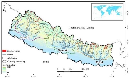
The study focused on the Northern part of Nepal, where the glacial lakes are located (Figure 1). The study area, Nepal, is located between 26°22′ to 30°27′N and 80°40′ to 88°12′E.
Nepal, with the longest section of the Himalaya (~800 km), occupies the central region of the Himalaya [37]. The climate of the Nepal Himalaya is mostly dominated by South Asian monsoons, and most of the precipitation occurs in the summer from June–September [38,39]. During the same period, river discharge is high in most of the river basins of Nepal [40]. The elevation of Nepal ranges from some 59 m in the Southern plains to 8848 m, the world’s highest peak, at Mt. Everest (Sagarmatha in Nepali language; meaning “Adobe of Snow”) in the Himalaya, with a high variation in topography, weather, and climate within the small latitudinal difference of the country. Nepal has a total land area of 147,181 km2 and a population of 26.4 million (estimated in 2011). Geographically, Nepal is distinctly divided into three physiographic regions, i.e., mountains, hills, and Terai (plain areas), with more than 80% of the country being mountainous [41]. The river basins of Nepal are of a transboundary nature; Nepal shares basin areas with Tibet, China in the north and India in the south, east, and west, with Nepal being in the middle [27]. In Nepal, the Koshi river basin in the Eastern region, the Gandaki river basin in the central region, and the Karnali river basin in the Western region are the areas from where the main rivers—Koshi, Gandaki, and Karnali—along with their tributaries flow towards the south. Another small Mahakali river basin is located in the far Western region of Nepal. The river basins were delineated by Hydrology Tool in ArcGIS using Shuttle Radar Topography Mission Digital Elevation Model Version 3 (SRTM DEM ver. 3) with 1-arc second resolution (30 m). The total area of glaciers in Nepal changed by 24% between 1977 and 2010 [42]. According to one estimate in 2014, the areas of the glaciers (both clean and debris-covered) in the Koshi, Gandaki, Karnali, and Mahakali river basins within Nepal were 1102, 1664, 1022, and 112 km2, respectively, in 2010. The area of debris-covered glaciers is higher in the Koshi river basin (217 km2) than in the Gandaki (123 km2) and Karnali (86 km2) river basins [42]. The study area is a region with a high number of reported and unreported GLOFs [20,43].
2.2. Data
We used optical imagery from different sensors onboard Landsat satellites (Table 1). Landsat data are widely used for mapping glacial lakes because of their high spatial and temporal coverage, moderate resolution (30 m), open access, and easy accessibility [9,44,45,46,47]. A total of 45 geometrically corrected Landsat Level 1 scenes that covered the whole study area were used and were downloaded from the United States Geological Survey’s (USGS) web portal (www.earthexplorer.usgs.gov). The details of the datasets used are provided in Table 1. The shadow and cloudiness in the high mountain areas with a monsoon climate complicated the selection of cloud and shadow free satellite data. The Landsat scenes acquired were from the post-monsoon season because the sizes of glacial lakes are stationary and changes are minor just after monsoon season; further, this season has less cloud cover and perennial snow coverage [9,36,48,49]. The acquired Landsat scenes of the study area had low cloud coverage (less than 10%) or were cloud-free. Whenever there was cloud, shadow, or lake ice or snow cover obstructing the identification of the lake area, imagery from the adjacent month or an alternative year was used. Nevertheless, to get good quality images, a period of ±1 or 2 years of data was used to represent the required year for the inventory (Table 1). For Nepal, Landsat data are not available for the early and mid-1980s. In the late 1980s, two scenes are not available for covering the whole study area. Thus, two Landsat TM scenes from the early 1990s were used in the inventory of glacial lakes for 1987.
The other data used were the Shuttle Radar Topography Mission Digital Elevation Model (SRTM DEM, 30 m) data which were assessed using a web interface (30 m SRTM Tile Downloader (dwtkns.com/srtm30m/)) and downloaded from the National Aeronautics and Space Administration’s (NASA) web portal (https://urs.earthdata.nasa.gov). Data from the Randolph Glacier Inventory (RGI) version 6.0 were downloaded from the Global Land Ice Measurements from Space (GLIMS) website (https://www.glims.org/RGI/) which was released on 28 July 2017.
2.3. Method
Many studies have used manual digitization [1,17,50] and normalized difference water index (NDWI) based automated or semiautomated methods for the delineation of glacial lake outlines [2,9,12,47,51]. The NDWI has been widely used for the delineation of water bodies (lakes) from remotely sensed digital imagery [52,53]. In this study, we used the semiautomated method, i.e., NDWI (Equation (1)) to delineate the glacial lake boundaries, combined with post-correction, by visually checking and editing for snow/ice cover and shadow components:
where and represent the top-of-atmosphere (TOA) reflectance for the green and Near Infrared (NIR) bands, respectively. For example, the maximum bandpass of the green and NIR bands in Landsat 8 are 0.525–0.6 and 0.845–0.885 µm, respectively [54].
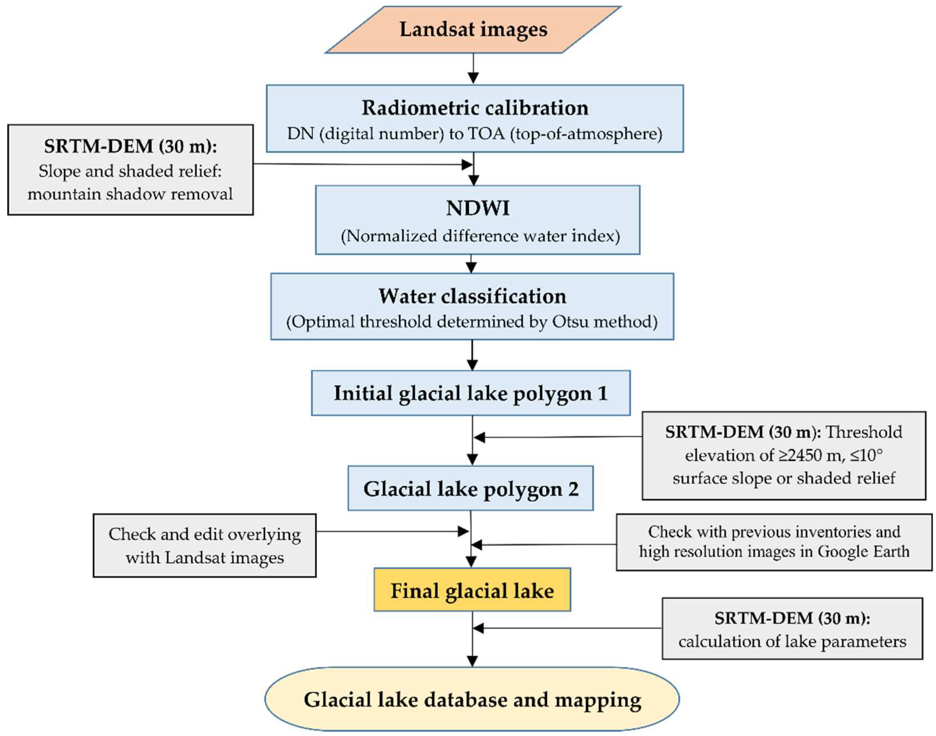
The overall data processing steps for the glacial lake inventory are shown in Figure 2. Landsat data were processed in ENVI software for band combination, radiometric calibration, and water feature extraction. An algorithm was used for automatic water classification to determine the optimal thresholds for NDWI images using two steps of global-local segmentation determined from the Otsu method [47,55]. The Otsu method [56] provides an optimal threshold, assuming that the image contains two classes of pixels following a bimodal histogram, one of which matches with a water body and the other with a nonwater body. This method helps to differentiate between water bodies and background noise, minimizing the probability of misclassification. Meanwhile, SRTM DEM was used to generate slope and shaded relief values to remove mountain shadows for reducing the misclassification of the water body from topographic effects. The shaded relief values were calculated as the cosine of the incidence angle (Cos (incidence angle) = Sin(elevation) ∗ Cos(slope) + Cos(elevation) ∗ Sin(slope) ∗ Cos (azimuth − aspect)) according to the sun elevation and the azimuth angle at the acquisition time of the Landsat image. The pixels identified as mountain shadow by the SRTM DEM-derived slope threshold of >10° and shaded relief of <0.25 [47] were removed from the NDWI images (Figure 2).
The initial lake polygons were further processed in ArcGIS. Previous studies used a 10 km buffer area from the nearest glacier to consistently identify the glacial lakes [1,9,23,49]. Here, firstly, a 10 km buffer area was prepared from the nearest glacier termini, and the lowest elevation of the glacial lake was recorded (~2450 m). This elevation was used as the minimum elevation threshold, and the presence of glacial lakes was thoroughly checked above 2450 m so that the maximum number of glacial lakes would be included. Generally, glacial lakes are located at higher elevations. The glacial lake with the lowest elevation in Nepal is an exception that is assumed to have formed after a glacier eroded the land and then melted to fill the space that it created [57]. The DEM-derived surface gradients of the areas where glacial lakes located are less than 10° [19]. Potential lake areas were defined as places with surface slopes of less than 10° or shaded relief values of larger than 0.25 [47]. Hence, the thresholds of ≥2400 m elevation and ≤10° surface slope were used for glacial lake mapping in Nepal. We also removed lake polygons whose average surface slopes were greater than 10° and classified them as mountain shadow [47]. However, the use of slope and shaded relief values was not sufficient to detect and remove all mountain shadow areas due to the complex rugged relief of the Himalaya and the accuracy of the DEM. Thus, the obtained polygons after the threshold application were checked again by overlaying with the Landsat images in different suitable band combinations. This step was necessary for the removal of misclassified polygons of glacial lakes due to shadow and also to ensure precise lake delineations. Lakes above 2450 m that were not glacial lakes were discarded by checking the nearest glacier and Google Earth visual interpretation; meanwhile, very few glacial lakes (n = 32) were found in the elevation zone of 2450–4000 m. In addition, quality assurance and quality control (QA/QC) procedures were conducted following the procedures mentioned in the previous studies [9,33]. The obtained lakes were cross-checked with previous data [1,20], historical images in Google Earth, and a base map of World Imagery (Esri, DigitalGlobe, GeoEye) to remove misclassified lakes and add a few missed lakes by manual digitization.
The automatic water classification method delineated lakes through histogram analysis and, thus, lakes were required to be larger than four pixels to allow better image segmentation [47]. Hence, a minimum threshold of 4 pixels was consistently set for mapping glacial lakes, as also suggested by Gardelle et al. (2011) [2]. For all inventories, 4 pixels corresponded to a lake size of 0.0036 km2, except for the year 1977. For the coarse resolution (60 m) Landsat multispectral scanner system (MSS) of the 1970s, we were able to map glacial lakes sized >0.0144 km2. Despite this limitation, the use of Landsat MSS for mapping glacial lakes helped us to generate knowledge on the historical lake changes from the 1970s. By following the aforementioned method, the complete inventories of the glacial lakes in Nepal for 1977, 1987, 1997, 2007, and 2017 were obtained and analyzed.
Previous studies estimated the uncertainties in the delineation of a glacial lake using satellite imagery as a product of the linear resolution error and the lake’s perimeter [17,49,58]. In those studies, a half pixel was adopted as the linear resolution error, assuming that, on average, the lake margin passes through the centers of pixels along its perimeter. Further, the uncertainties in the total glacial lake area were derived using the error propagation rule, i.e., the root sum of the squares of the individual lake mapping errors.
For all inventories, glacial lakes were classified into two categories, glacier-fed and nonglacier-fed lakes, in accordance with previous studies [1,9,49,50]. Further, glacier-fed lakes were classified into supraglacial lakes (those on the surface of glaciers), proglacial lakes with ice contact (connected with glacier and usually lie at the lateral or terminus position of glacier), and unconnected glacier-fed lakes (that are detached from the current glacier, but are fed by meltwater from glaciers), with the help of RGI version 6 data, following the techniques mentioned by previous studies [2,50] and extensive Google Earth visual interpretation [1,49]. In general, glacier-fed lakes are those lakes that contain at least one glacier in their basin and are fed by glacier meltwater, whereas nonglacier-fed lakes do not get their supply from glacier melt but rather, are fed by snowmelt and precipitation [49]. Those lakes are considered as nonglacier-fed lakes that lie within the 10 km buffer area from the nearest glacier and are not connected to a glacial watershed [50]. Thus, the dataset with both glacier-fed and nonglacier-fed lakes can be referred to as alpine lakes. For Google Earth visual interpretation, first of all, each glacial lake was assigned a unique code in ArcGIS and converted into a KML file. Secondly, the KML files of glacial lakes and RGI version 6 data were loaded into Google Earth; each glacial lake was classified using its respective code. At last, the classified lakes were joined in ArcGIS. The SRTM DEM (30 m) was used to calculate the lake parameters, such as elevation.
3. Results
3.1. Glacial Lakes in 2017, Nepal
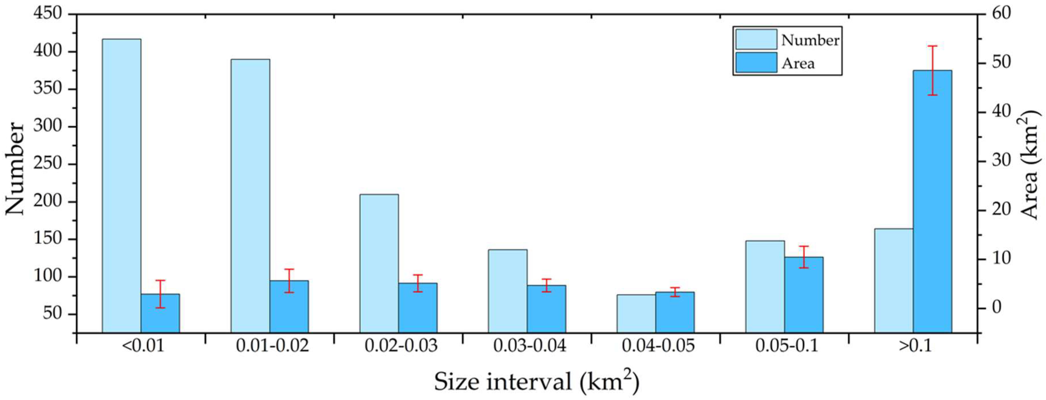
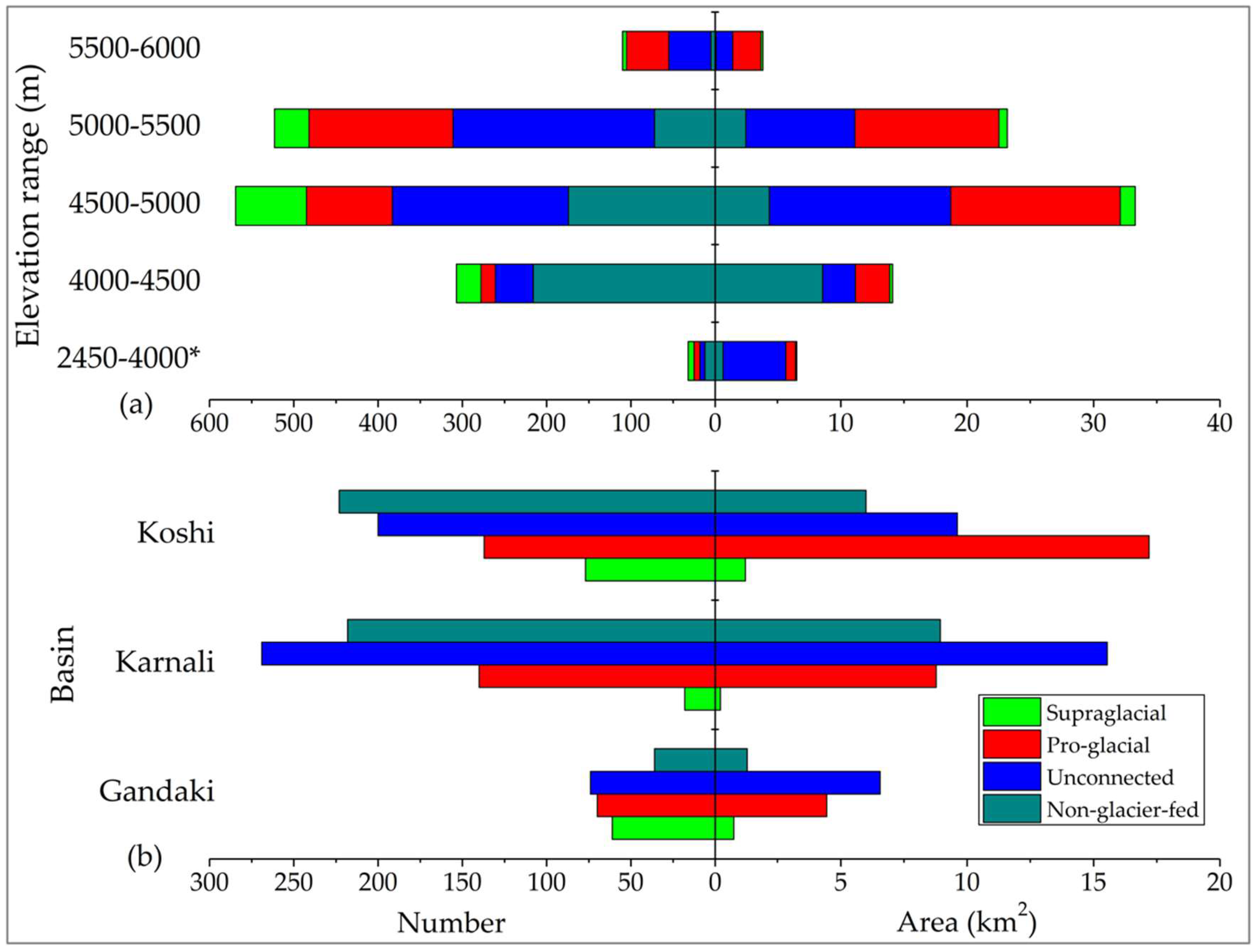
The mapping of glacial lakes across the Nepal Himalaya revealed 1541 glacial lakes with a total area of 80.95 ± 15.25 km2 in 2017 (Figure 1). The maximum glacial lake size found was 4.61 ± 0.33 km2 (Phoksundo Lake) and the average size of the mapped glacial lakes was calculated to be ~0.05 km2. Small glacial lakes of <0.05 km2 account for 80% of the total number of glacial lakes; however, glacial lakes of ≥0.05 km2 contribute to 73% of the total area of glacial lakes (Figure 3). The glacial lakes in the Nepal Himalaya fall into the elevation range of 2456–5908 m, with a mean elevation of 4873 m. Almost 98% of the glacial lakes lie above 4000 m (Figure 4).
Out of the total alpine lakes (1541) in the Nepal Himalaya, this study identified 1064 (64.69 km2) glacial lakes as glacier-fed lakes and the remaining 477 (16.26 km2) as nonglacier-fed lakes. Further, out of the 1064 glacier-fed lakes, 166 (2.33 km2) were identified as supraglacial lakes, 349 (30.52 km2) as proglacial lakes with ice contact, and 549 (31.84 km2) as unconnected, but glacier-fed lakes. These glacial lakes are spatially distributed over different river basins and sub-basins of Nepal (Figure 1; Table 2). The mean elevation of glacial lakes in the Koshi river basin is the lowest (4837 m), as compared to the Karnali (4907 m) and Gandaki (4910 m) river basins. This could be attributed to the hypsometry of glaciers in different basins. For instance, the mean elevation of glaciers in the Koshi river basin is the lowest, followed by the Karnali and Gandaki river basins, respectively [42]. Among the four major river basins of Nepal, the maximum glacial lake area is in the Koshi river basin (Table 2; Figure 4). Comparing the glacial lakes in the three major basins (Figure 4), overall, the number and surface area of the glacial lakes in the Gandaki River basin are the lowest. The total surface areas of glacial lakes as a percentage of the total surface area of glaciers in the Koshi, Gandaki, Karnali, and Mahakali river basins are 3.1%, 0.8%, 3%, and 0.3%, respectively (as mentioned in Section 2.1). The area of proglacial lakes in the Koshi river basin exceeds that of the Karnali river basin by almost 96%; however, the number and surface area of unconnected glacial lakes are the highest in the Karnali river basin (Figure 4). Supraglacial lakes have a dominant presence in the Koshi river basin over the Gandaki river basin, with the lowest count occurring in the Karnali river basin. The amount of debris-covered areas in the Karnali river basin is 150% less than in the Koshi river basin [42], as mentioned in Section 2.1. The extent and thickness of debris-covered areas influence the surface slopes and velocities of the glaciers, which are the conditions required for the formation and expansion of supraglacial lakes [19,59,60]. A high number of supraglacial lakes was reported in large debris-covered glaciers in the Everest region [61], where debris cover was found to increase by ~18% between 1962 and 2011 [62]. Meanwhile, the presence and development of supraglacial lakes accelerates glacier recession [63].
3.2. Decadal Dynamics of Glacial Lakes
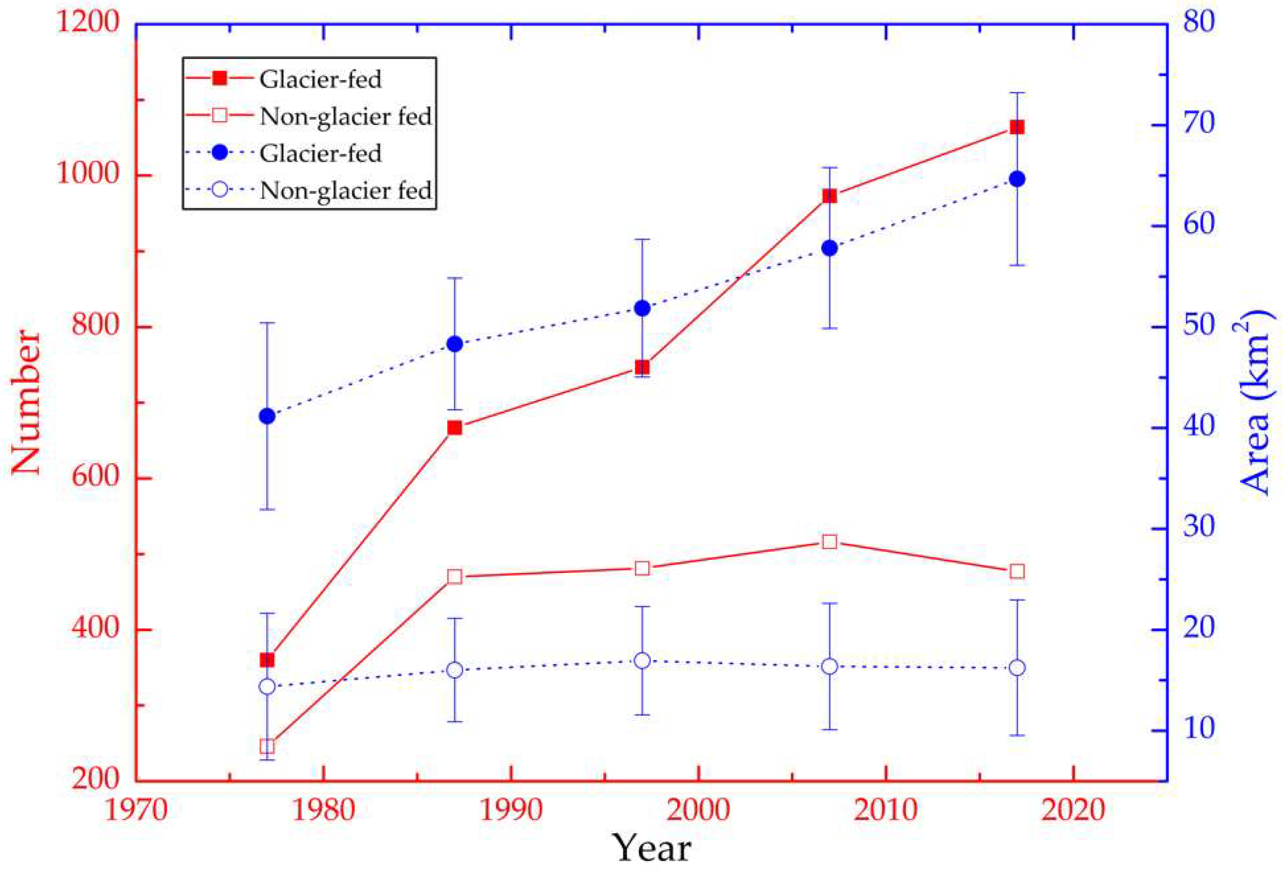
The decadal mapping of glacial lakes across the Nepal Himalaya from 1977 to 2017 shows the increase in the number and area of glacial lakes over time (Figure 5). The glacial lake area expanded at rates of 1.63% year−1 between 1977 and 1987, 0.67% year−1 between 1987 and 1997, 0.77% year−1 between 1997 and 2007, and 0.91% year−1 between 2007 and 2017. The number of glacial lakes drastically increased by ~21% between 1997 and 2007 because of the high number (n = 345) of emerging supraglacial lakes and small proglacial lakes of considerable size (≥0.0036 km2) during this period (Table 3 and Table S1). The overall change in the total surface area of glacial lakes in 1977−2017 and 1987−2017 was ~46% and ~25%, respectively (Table 3). The results of glacial lake expansion from 1977 to 1987 have high uncertainty due to the use of low-resolution of MSS data in 1977. The large increase in the number of glacial lakes between 1977 and 1987 is related to spatial and spectral resolution differences in the imagery used for mapping, and the contrast between the mapping sizes used for Landsat MSS and TM imagery is mentioned in Section 2.3. For example, a total of 190 nonglacier-fed lakes of size <0.014 km2 were mapped in 1987 using Landsat TM images, which could not be mapped in 1977 due to the employed mapping size (>0.014 km2) of the Landsat MSS images.
3.2.1. Glacial Lake Changes by Various Size Classes and Different Types
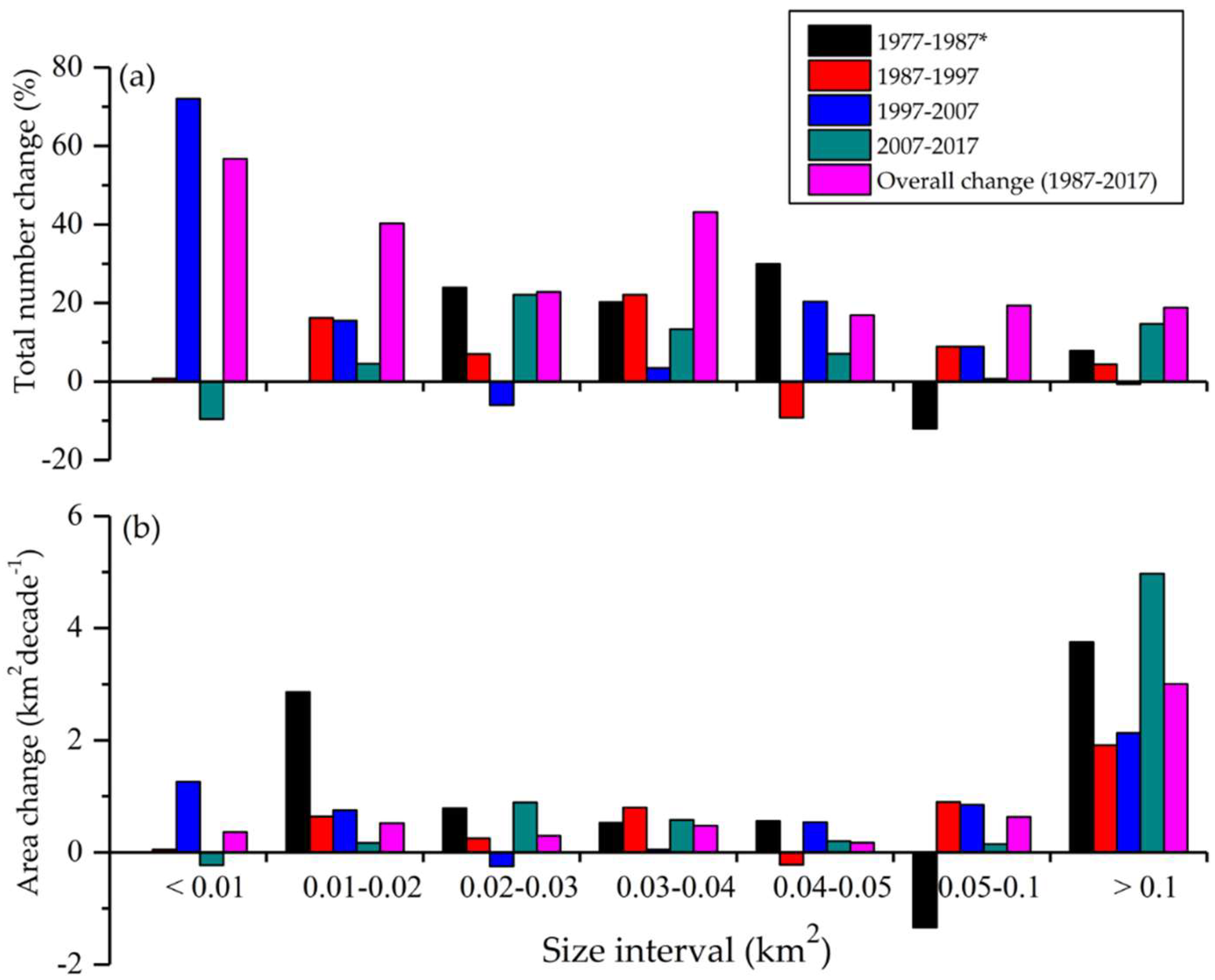
Glacial lakes of various size classes and types showed contrasting decadal changes in their number and area between 1977 and 2017 (Table 3; Figure 6). Among different size classes of glacial lakes, small-size glacial lakes (<0.01 km2) experienced the highest amount of fluctuation in their number, increasing by ~57% during 1987–2017. For instance, 84 supraglacial lakes (<0.01 km2) were mapped in 2017, which is higher by 57 than in 1987. However, the number of small glacial lakes (<0.01 km2) decreased in the recent period of 2007–2017. Overall, glacial lakes of size ≥0.1 km2 experienced the highest expansion rate of 3.19 km2 decade−1 between 1977 and 2017 and 3 km2 decade−1 between 1987 and 2017 (Figure 6).
In the decades of 1987–1997, 1997–2007, and 2007–2017, the total number of glacier-fed lakes increased by 12%, 30%, and 9%, and their areas expanded by 0.35 km2 year−1, 0.60 km2 year−1, and 0.68 km2 year−1, respectively. This suggests that glacier-fed lakes exhibited a continuous increment in the surface area expansion rate from 1987 to 2017. Among the different types of glacial lake, proglacial lakes exhibited the highest change in the total number and surface area, increasing by 181% and 82%, respectively, between 1987 and 2017. Meanwhile, the results show that nonglacier-fed lakes exhibited the lowest changes of 1% each in their total number and area, between 1987 and 2017 (Table 3). It could be noted that the lowest changes in the total number and area of nonglacier-fed lakes between the periods of 1987 to 2017 (Figure 5) support our methods, since these lakes have no common mechanism for expansion and emergence or disappearance. For example, the total number and area of nonglacier-fed lakes with a size of >0.1 km2 was similar between 1987 (36, 5.53 ± 0.9 km2) and 2017 (34, 5.44 ± 0.9 km2). In the last two decades (1997–2007 and 2007–2017), nonglacier-fed lakes experienced a continuous decrease in their total area by −3% and −1%, respectively.
3.2.2. Spatial and Temporal Dynamics of Lakes Across Different Basins and Elevation Zones
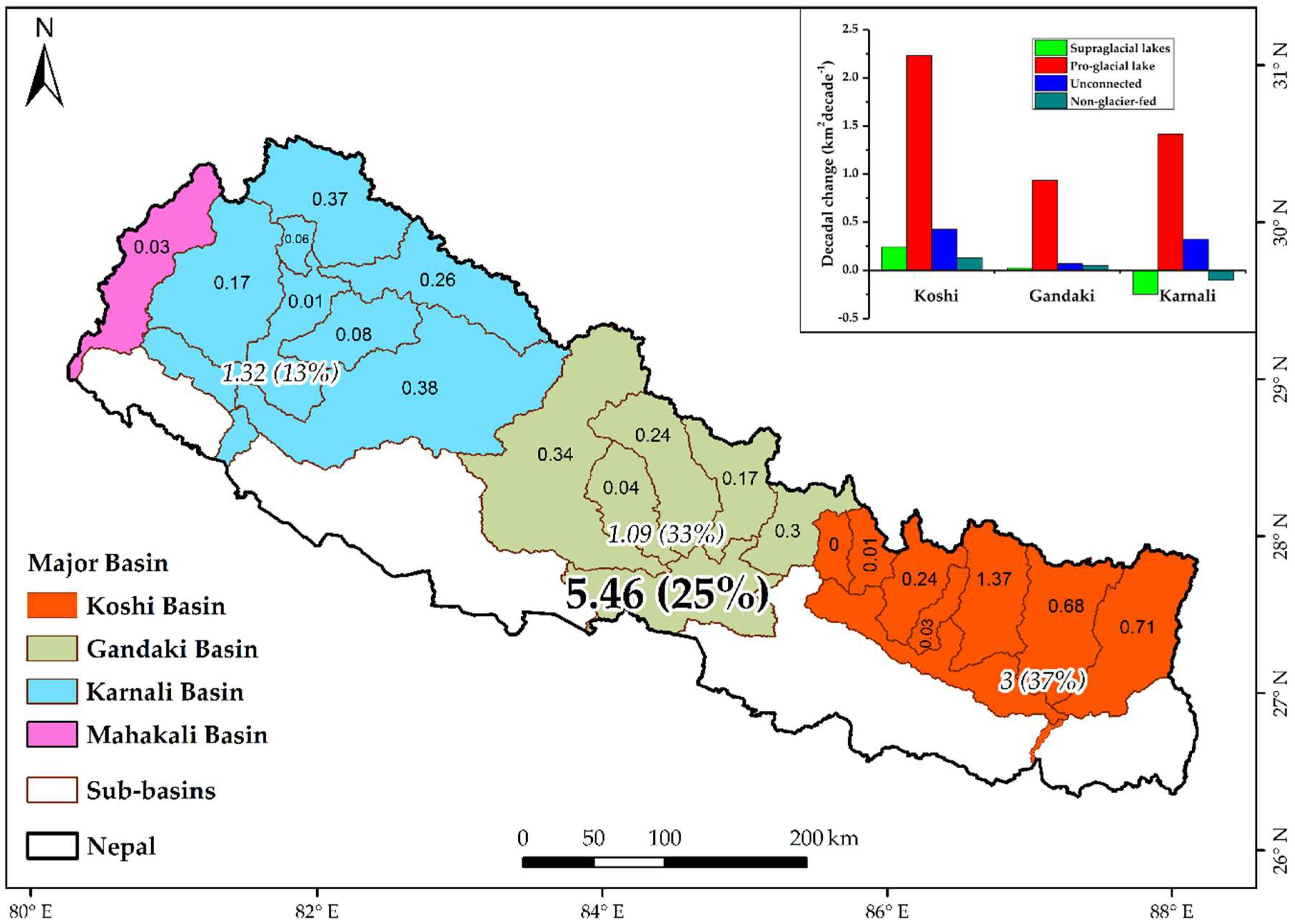
The glacial lakes across the Nepal Himalaya display spatial and temporal variations over different river basins and elevation zones. The number of glacial lakes in the Koshi, Gandaki, and Karnali river basins increased by 45%, 96%, and 14%, whereas the area expanded by 0.3 km2 year−1, 0.11 km2 year−1, and 0.13 km2 year−1, respectively, between 1987 and 2017. This result reveals that the glacial lakes of the Koshi river basin in Eastern Nepal experienced higher surface area expansion (km2 year−1). The total number of glacial lakes in the far Western, small Mahakali river basin increased to 19 (0.33 km2) in 2017 from 10 (0.23 km2) in 1987. Different types of glacial lakes in the major three basins exhibited differential expansion rates, with proglacial lakes representing the highest expansion in the Koshi river basin (inset of Figure 7). Among the different sub-basins of the major rivers, the glacial lakes in the DudhKoshi river basin had the highest decadal expansion of 1.37 km2 decade−1 (Figure 7). This implies that the downstream population of the DudhKoshi basin is highly susceptible to GLOF hazards.
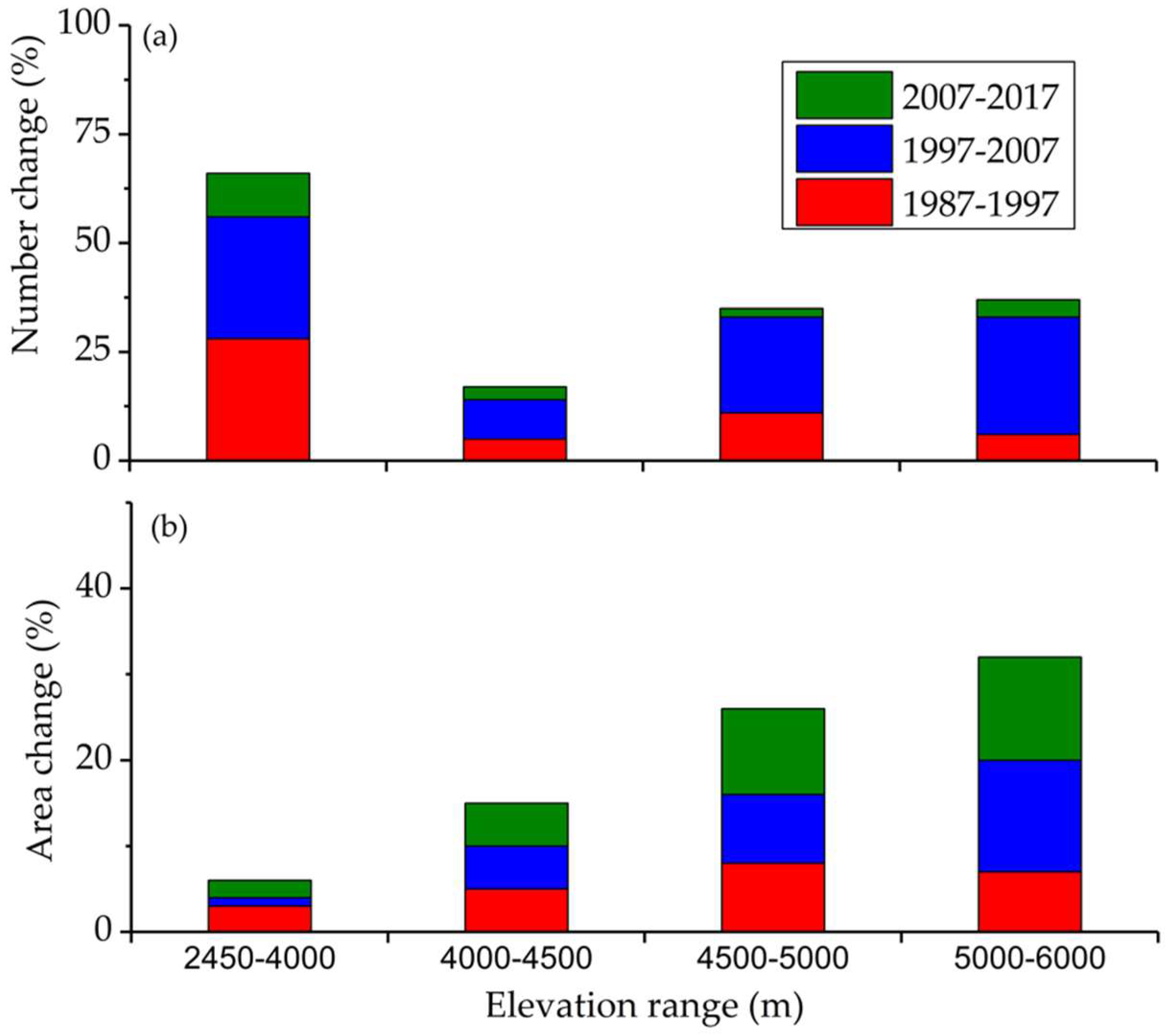
The glacial lakes in the elevation ranges of 2400–4000, 4000–4500, 4500–5000, and ≥5000 m expanded by 0.05, 0.09, 0.3, and 0.41 km2 year−1, respectively, in the period 1987–2017. This reveals that the glacial lakes located in higher elevation ranges experienced more expansion than glacial lakes located at lower elevation zones (Figure 8). About 71% and 75% of the evolved glacial lakes in 1977–2017 and 1987–2017, respectively, lie at elevations between 4500 and 5500 m. According to one estimate, the average terminuses of mountain and valley glaciers in Nepal were 5220 and 4355 m, respectively, in 2010 [42]. This indicates that the majority of newly evolved glacial lakes in Nepal lie in the periphery of the same elevation range of the retreating glacier terminuses [32]. The positions of lakes and glaciers can lead to dynamic interaction between them, eventually favoring an increase in lake area and enhancing the mass loss of the glaciers [59,63,64,65]. The lakes also showed as high expansion in the same elevation range as that of the retreating glacier terminus. Song et al. (2018) [64] noted that the lake expansion depends on the mean slope of the retreating glacier terminus position, and the shrinkage of glacier fronts provides an area for lake expansion.
3.2.3. Emergence and Disappearance of Lakes
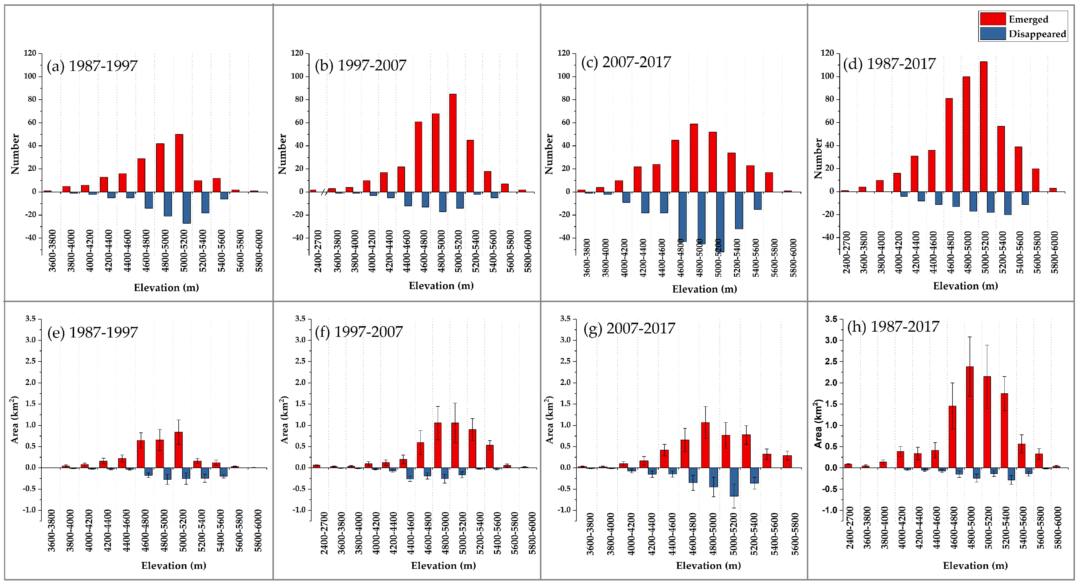
The glacial lakes in the Nepal Himalaya exhibited apparent decadal emergence and disappearance between 1987 and 2017 within our mapping scale of 0.0036 km2 (Figure 9). Considering lakes as a whole from 1987 to 2017, 511 new glacial lakes with a total area of 10.1 km2 emerged and 102 glacial lakes with a total area of 1.1 km2 disappeared or significantly drained (Figure 9 and Table S1). The lakes that disappeared had a minimal total area, indicating nominal disappearance. The disappearance of small lakes can be attributed to transient supraglacial lakes and drainage of water. The glacial lakes that emerged were located between the elevations of 2456 and 5893 m, with a mean elevation of 4941 m, while glacial lakes that disappeared were located between the elevations of 4043 and 5600 m, with a mean elevation of 4920 m (Figure 9). Regarding the major river basins, glacial lakes greatly emerged in the Koshi river basin (predominantly supraglacial lakes). Meanwhile, a significant disappearance of glacial lakes occurred in the Karnali river basin in the same period of 1987 to 2017 (Tables S2 and S3). Among the different types of glacial lakes, proglacial lakes were the most prevalent type of newly emerging glacial lake, with a total number and area of 179 and 5.65 km2, respectively, from 1987 to 2017. Concurrently, nonglacier-fed (42) lakes were the most common type to significantly drain or disappear, followed by supraglacial lakes (28), within our mapping scale of 0.0036 km2 (Tables S2 and S3).
4. Discussion
4.1. Mapping and Comparison with the Previous Studies
Glacial lake mapping is affected by the resolution and quality of data used, the mapping procedures, and the thresholds (minimum size, elevation threshold, and maximum distance from glaciers) required for the study. The use of 0.0036 km2 as the minimum mapping size controlled the size and total number of glacial lakes identified. Although the number of small lakes is high, they add little to the total area. Many supraglacial lakes are small, transient, and dynamic in nature [17,61,66]. In this context, we were only able to map supraglacial lakes that were visible in the imagery used within the employed mapping size (≥0.0036 km2). The use of coarse resolution MSS data (60 m) highly affects the inventory and the results compared; however, this data disseminates valuable historical information about glacial lakes. Hence, in this context, MSS data were used to map lakes >0.0144 km2, and to give consistency in the results, we mainly focused on the overall changes from 1987 to 2017, using the same data resolution of 30 m. The established way of finding the uncertainty of glacial lake extent (i.e., ±½ pixel × lake perimeter) yields a higher error rate, especially when there are a high number of small-sized glacial lakes [17]. For example, in 2017, glacial lakes of size <0.05 km2 accounted for 80% of the total number and contributed to 27% of the total area; however, their errors accounted for ~55% of the total number of errors. This also applied to other inventories.
This study upgraded and updated the former inventory of glacial lakes in Nepal executed by manual digitization of Landsat imagery from 2005/2006 [20], with a new inventory from 2017 by Landsat 8. This was computed using a semiautomatic method, which revealed a higher number and area of glacial lakes than previous studies (Table 4). Though mapping shows thousands of glacial lakes in Nepal, many pose no significant GLOF hazard to people [23]. The overall lake expansion (25% in 30 years) is congruent with a previous study [9], which reported ~23% lake expansion in the Southern central Himalaya (Nepal and some parts of India) over a period of 25 years (Table 4), thus validating the results of current study. Compared with other regional studies [1,9], the glacial lakes in the Nepal Himalaya account for ~27% and ~15% of the total number and area of glacial lakes, respectively, in the third pole, and ~31% and ~18% of the total number and area of glacial lakes, respectively, in the entire Himalaya (Table 4). A recent study of glacial lakes in the Koshi river basin overestimated the total number and area of the lakes because it did not apply a threshold for the maximum glacier–lake distance to map glacial lakes, and also, the quality control and assurance procedures were not explained [48].
4.2. Evolution of the Lowest Elevation Glacial Lake
Many of the newly emerged glacial lakes in the Nepal Himalaya are located at higher elevation zones (>4600 m, Figure 8), following the trend reported for the entire Himalaya [9] and Tibetan Plateau [45]. This may be due to up-valley retreating and down-wasting of glaciers [62] that has resulted in the proliferation of new glacial lakes. King et al. (2018) [59] showed that the continuous expansion of debris covering up glaciers has resulted in decreases in surface slopes and reductions in ice flow (conditions favorable for lake formation) in the Everest regions (Nepal and Tibet) of central Himalaya. They examined the nine land-terminating glaciers in the same region and found that five of them showed substantial formation of supraglacial lakes (>0.02 km2) in between 2000 and 2015, further emphasizing that subdebris melt leads to expansion [59]. The DudhKoshi, a large glacierized basin in Nepal, is covered by 70% valley type glaciers, which retreated at rates of 10–74 m year−1 between 1976 and 2007, resulting in the formation of 24 new glacial lakes at elevations between 4349 and 5636 m between 2000 and 2007 [68]. Notably, previous key studies [4,9,20] did not report the glacial lake at the lowest elevation (~2456 m). The 2010 inventories by ICIMOD used 3500 m as the minimum elevation threshold, accepting that this elevation represents the approximate lower limit of glacial moraine accumulations in Nepal [20]. However, our study shows a new glacier-fed lake (Kawache glacial lake) of considerable size ~0.1 km2 in the Gandaki river basin at an elevation of ~2456 m in 2017. Based on Landsat imagery, we found that this lake was not present before 2002 and started to appear by 2003, growing to ~0.014 km2 in 2006. The evolution map (Figure S1) shows the formation of two glacial lakes in 2007 that coalesced to form a single lake of 0.085 km2 in 2009. The present area of the lake in 2017 is ~0.1 km2, a slight decrease of 0.01 km2 compared to 2013. Though the lake area has decreased slightly, this glacial lake needs further investigation regarding its potential GLOF risk.
4.3. Causes of the Differential Expansion of the Glacial Lakes
Glacial lakes are an indirect indicator of climate change. The combination of climatic factors (temperature and precipitation) and glacial hydrogeomorphic processes has been dynamically driving glacial lake changes in the Himalaya [9,55,69]. An analysis of data from 1974–2014 shows an average annual maximum temperature warming trend of 0.056 °C year−1 in Nepal [70]. In the high altitude regions (>5000 m) of Eastern Nepal (Everest region), the mean annual temperature has increased by +0.44 °C year−1, while the annual monsoon precipitation weakened by −9.3 mm year−1 during 1994–2013 [38,71]. The pronounced warming in high altitude regions of Nepal with a significant decrease of precipitation [38,72] is causing the retreat and negative mass balance of glaciers in Nepal, favoring lake expansion. For instance, the mean mass balance of 32 glaciers in the Everest regions (Nepal and Tibet) was –0.5 ± 0.22 m water equivalent (w.e.) year−1 in the period 2000–2015 [32]. Retreating glaciers are affecting the dynamics of glacial lakes and vice versa. For example, lacustrine terminating glaciers are retreating at faster rates, causing the proglacial lakes to expand. Meanwhile, the thermal cutting from the lake water is enhancing the calving from glaciers, eventually forming a space for upward proglacial lake expansion [32,50,64,69,73]. This is the convincing reason why the contribution of proglacial lakes (with ice contact) is highest in the total expansion of glacial lakes, compared to other types of glacial lake. The annual mean monsoon and post-monsoon precipitation are higher in the Eastern region than in the Western region [70]. This might be the reason why the nonglacial-fed lakes that rely upon precipitation in the Western Karnali river basin exhibited contraction (inset of Figure 6). The evolution and extent of glacial lake expansion depend on the activities of the mother glacier, the geometry of the glaciers and glacial lake, and the bed-rock topography [17,63,64,65,74,75]. A glacial lake with a large width at the calving front expands more rapidly, since lake water and glacier interactions become pronounced [64,65]. A lake that is confined by either lateral moraines or bed-rock has little or no possibility of future expansion [26]. The changes in the surface areas of unconnected glacial lakes (no ice contact) depend on water from glacier melt or precipitation [2,71].
The basin-to-basin differences in evolution and area changes of lakes in the Nepal Himalaya could be attributed to spatial heterogeneous recessions of glaciers. In 1962–2011, the glaciers in the Everest region were found to be significantly shrinking and retreating [62], supporting the fact that the glacial lakes in the DudhKoshi sub-basin have undergone the greatest expansion in Nepal (Figure 6) and were found to be at greater risk of burst [23]. Glacier changes control the dynamics of a glacial lake. In the DudhKoshi basin, the average minimum temperature has risen [38], glaciers have experienced negative mass balance [32], and glaciers are projected to exhibit continued mass loss in the future [76]. It can be concluded that climate change is the main reason for the glacier recession and, hence, glacial lake expansion.
5. Conclusions
We employed open access Landsat imagery to map and prepare inventories of the glacial lakes in Nepal. Further, we analyzed the decadal variations in glacial lakes from 1977 to 2017 in Nepal. A total of 1541 glacial lakes (in 2017; size ≥0.0036 km2) with a surface area of 80.95 ± 15.25 km2 were mapped across the Nepal Himalaya. Small-sized glacial lakes (>0.05 km2) are predominant in Nepal. The results indicate that the total surface area of glacial lakes in Nepal expanded by 25% between 1987 and 2017. The glacial lakes in different river basins of Nepal differ in terms of the total number, area, and size and exhibited heterogeneous expansion from 1977 to 2017. The glacial lakes in the Eastern Koshi basin have undergone greater expansion than other two major basins (Gandaki and Karnali) in Nepal. Among the various types of glacial lake, proglacial lakes connected with glaciers expanded the most in the Nepal Himalaya, which is in line with the glacier retreat reported in the region [62]. The risk of GLOFs from the DudhKoshi basin is high, as the glacial lakes in this basin were found to have greater expansion rates than other basins. A significant disappearance and development of glacial lakes occurred between 1987 and 2017. Despite the majority of newly emerged glacial lakes developing at higher altitudes, in the last decade, a glacial lake of considerable size evolved at the lowest elevation (~2456 m) in central Nepal.
In the context of climate change, the proliferation of new glacial lakes and the expansion of existing ones are expected to increase in the future. We emphasize that the expanding glacial lakes add to the risk of GLOFs. Hence, regular monitoring of glacial lakes is required. Decadal updates of the inventory of glacial lakes with new data and techniques are necessary to upgrade the existing database, provide the latest enhanced knowledge, and shape and reform national policies.
Supplementary Materials
The following are available online at https://0-www-mdpi-com.brum.beds.ac.uk/2072-4292/10/12/1913/s1, Table S1: The decadal dynamics of newly emerged and disappeared glacial lakes in Nepal. Table S2: Total number of newly emerged glacial lakes by type in different basins between 1987 and 2017. The values in the parentheses indicate the total area (km2) of the respective glacial lakes. Table S3: Total number of disappeared glacial lakes in different basins by type between 1987 and 2017. The values in the parentheses indicate the total area (km2) of the respective glacial lakes. Figure S1: Evolution map of Kawache glacial lake at the lowest elevation (~2456 m) in the Kaski district of Nepal, obtained from the Landsat TM imagery from 2003, 2006, and 2007 and Landsat OLI imagery from 2013 and 2017.
Author Contributions
N.K. and G.Z. developed the research idea. N.K. collected the data, processed the data, and wrote the manuscript. G.Z. and S.T. contributed to data interpretation, discussion, and revision of the manuscript. All authors have read, revised, and approved the manuscript.
Funding
This study was supported by grants from the Natural Science Foundation of China (41871056, 21661132003, 41571068, and 41571061), and the Strategic Priority Research Program (A) of the Chinese Academy of Sciences (XDA20060201).
Acknowledgments
The authors are grateful to USGS, NASA, and GLIMS teams for the production of open access data. We thank Binod Baniya (IGSNRR), Shravan Kumar Ghimire, and Siddhartha Environmental Services, Kathmandu for the support in this study. The authors extend sincere gratitude to the editor and the anonymous reviewers for their constructive comments and valuable suggestions.
Conflicts of Interest
The authors declare no conflict of interest.
References
- Zhang, G.; Yao, T.; Xie, H.; Wang, W.; Yang, W. An Inventory of Glacial Lakes in the Third Pole Region and Their Changes in Response to Global Warming. Glob. Planet. Chang. 2015, 131, 148–157. [Google Scholar] [CrossRef]
- Gardelle, J.; Arnaud, Y.; Berthier, E. Contrasted Evolution of Glacial Lakes along the Hindu Kush Himalaya Mountain Range between 1990 and 2009. Glob. Planet. Chang. 2011, 75, 47–55. [Google Scholar] [CrossRef] [Green Version]
- Yao, T.; Thompson, L.; Yang, W.; Yu, W.; Gao, Y.; Guo, X.; Yang, X.; Duan, K.; Zhao, H.; Xu, B. Different Glacier Status with Atmospheric Circulations in Tibetan Plateau and Surroundings. Nat. Clim. Chang. 2012, 2, 663–667. [Google Scholar] [CrossRef]
- Ives, J.D.; Shrestha, R.B.; Mool, P.K. Formation of Glacial Lakes in the Hindu Kush-Himalayas and Glof Risk Assessment; ICIMOD: Kathmandu, Nepal, 2010. [Google Scholar]
- Bajracharya, S.R.; Mool, P.K.; Shrestha, B.R. Impact of Climate Change on Himalayan Glaciers and Glacial Lakes: Case Studies on Glof and Associated Hazards in Nepal and Bhutan; International Centre for Integrated Mountain Development: Kathmandu, Nepal, 2007. [Google Scholar]
- Ren, J.; Qin, D.; Kang, S.; Hou, S.; Pu, J.; Jing, Z. Glacier Variations and Climate Warming and Drying in the Central Himalayas. Sci. Bull. 2004, 49, 65–69. [Google Scholar] [CrossRef]
- Lutz, A.; Immerzeel, W.; Bajracharya, S.; Litt, M.; Shrestha, A. Impacts of Climate Change on the Cryosphere, Hydrological Regimes and Glacial Lakes of the Hindu Kush Himalayas: A Review of Current Knowledge; ICIMOD Working Paper (Nepal) Eng No. 2016/3; ICIMOD: Kathmandu, Nepal, 2016. [Google Scholar]
- Richardson, S.D.; Reynolds, J.M. An Overview of Glacial Hazards in the Himalayas. Quat. Int. 2000, 65, 31–47. [Google Scholar] [CrossRef]
- Nie, Y.; Sheng, Y.; Liu, Q.; Liu, L.; Liu, S.; Zhang, Y.; Song, C. A Regional-Scale Assessment of Himalayan Glacial Lake Changes Using Satellite Observations from 1990 to 2015. Remote Sens. Environ. 2017, 189, 1–13. [Google Scholar] [CrossRef]
- Shijin, W.; Tao, Z. Spatial Change Detection of Glacial Lakes in the Koshi River Basin, the Central Himalayas. Environ. Earth Sci. 2014, 72, 4381–4391. [Google Scholar] [CrossRef]
- Nie, Y.; Liu, Q.; Wang, J.; Zhang, Y.; Sheng, Y.; Liu, S. An Inventory of Historical Glacial Lake Outburst Floods in the Himalayas Based on Remote Sensing Observations and Geomorphological Analysis. Geomorphology 2018, 308, 91–106. [Google Scholar] [CrossRef]
- Somos-Valenzuela, M.; McKinney, D.C.; Rounce, D.R.; Byers, A. Changes in Imja Tsho in the Mount Everest Region of Nepal. Cryosphere 2014, 8, 1661–1671. [Google Scholar] [CrossRef]
- Watanabe, T.; Lamsal, D.; Ives, J.D. Evaluating the Growth Characteristics of a Glacial Lake and Its Degree of Danger of Outburst Flooding: Imja Glacier, Khumbu Himal, Nepal. Nor. Geogr. Tidsskr. J. Geogr. 2009, 63, 255–267. [Google Scholar] [CrossRef]
- Carrivick, J.L.; Tweed, F.S. A Global Assessment of the Societal Impacts of Glacier Outburst Floods. Glob. Planet. Chang. 2016, 144, 1–16. [Google Scholar] [CrossRef]
- Yamada, T.; Sharma, C. Glacier Lakes and Outburst Floods in the Nepal Himalaya. Publ. Int. Assoc. Hydrol. Sci. 1993, 218, 319–330. [Google Scholar]
- Harrison, S.; Kargel, J.S.; Huggel, C.; Reynolds, J.; Shugar, D.H.; Betts, R.A.; Emmer, A.; Glasser, N.; Haritashya, U.K.; Klimeš, J. Climate Change and the Global Pattern of Moraine-Dammed Glacial Lake Outburst Floods. Cryosphere 2018, 12, 1195–1209. [Google Scholar] [CrossRef]
- Salerno, F.; Thakuri, S.; D’Agata, C.; Smiraglia, C.; Manfredi, E.C.; Viviano, G.; Tartari, G. Glacial Lake Distribution in the Mount Everest Region: Uncertainty of Measurement and Conditions of Formation. Glob. Planet. Chang. 2012, 92, 30–39. [Google Scholar] [CrossRef]
- Bolch, T.; Buchroithner, M.; Peters, J.; Baessler, M.; Bajracharya, S. Identification of Glacier Motion and Potentially Dangerous Glacial Lakes in the Mt. Everest Region/Nepal Using Spaceborne Imagery. Nat. Hazards Earth Syst. Sci. 2008, 8, 1329–1340. [Google Scholar] [CrossRef]
- Quincey, D.; Richardson, S.; Luckman, A.; Lucas, R.M.; Reynolds, J.; Hambrey, M.; Glasser, N. Early Recognition of Glacial Lake Hazards in the Himalaya Using Remote Sensing Datasets. Glob. Planet. Chang. 2007, 56, 137–152. [Google Scholar] [CrossRef]
- ICIMOD. Glacial Lakes and Glacial Lakes Outburst Floods in Nepal; ICIMOD: Kathmandu, Nepal, 2011. [Google Scholar]
- Watanabe, T.; Ives, J.D.; Hammond, J.E. Rapid Growth of a Glacial Lake in Khumbu Himal, Himalaya: Prospects for a Catastrophic Flood. Mt. Res. Dev. 1994, 14, 329–340. [Google Scholar] [CrossRef]
- Shrestha, A.; Eriksson, M.; Mool, P.; Ghimire, P.; Mishra, B.; Khanal, N. Glacial Lake Outburst Flood Risk Assessment of Sun Koshi Basin, Nepal. Geomat. Nat. Hazards Risk 2010, 1, 157–169. [Google Scholar] [CrossRef]
- Rounce, D.R.; Watson, C.S.; McKinney, D.C. Identification of Hazard and Risk for Glacial Lakes in the Nepal Himalaya Using Satellite Imagery from 2000–2015. Remote Sens. 2017, 9, 654. [Google Scholar] [CrossRef]
- Khanal, N.R.; Mool, P.K.; Shrestha, A.B.; Rasul, G.; Ghimire, P.K.; Shrestha, R.B.; Joshi, S.P. A Comprehensive Approach and Methods for Glacial Lake Outburst Flood Risk Assessment, with Examples from Nepal and the Transboundary Area. Int. J. Water Resour. Dev. 2015, 31, 219–237. [Google Scholar] [CrossRef]
- Khanal, N.R.; Hu, J.-M.; Mool, P. Glacial Lake Outburst Flood Risk in the Poiqu/Bhote Koshi/Sun Koshi River Basin in the Central Himalayas. Mt. Res. Dev. 2015, 35, 351–364. [Google Scholar] [CrossRef]
- Lamsal, D.; Sawagaki, T.; Watanabe, T.; Byers, A.C. Assessment of Glacial Lake Development and Prospects of Outburst Susceptibility: Chamlang South Glacier, Eastern Nepal Himalaya. Geomat. Nat. Hazards Risk 2016, 7, 403–423. [Google Scholar] [CrossRef]
- Chen, N.S.; Hu, G.S.; Deng, W.; Khanal, N.; Zhu, Y.; Han, D. On the Water Hazards in the Trans-Boundary Kosi River Basin. Nat. Hazards Earth Syst. Sci. 2013, 13, 795–808. [Google Scholar] [CrossRef]
- Xu, D. Characteristics of Debris Flow Caused by Outburst of Glacial Lake in Boqu River, Xizang, China, 1981. GeoJournal 1988, 17, 569–580. [Google Scholar] [CrossRef]
- Chen, X.Q.; Cui, P.; Li, Y.; Yang, Z.; Qi, Y.Q. Changes in Glacial Lakes and Glaciers of Post-1986 in the Poiqu River Basin, Nyalam, Xizang (Tibet). Geomorphology 2007, 88, 298–311. [Google Scholar] [CrossRef]
- Qiu, J. Glacial Lakes Threaten Himalayan Dams. Scientific American. 2016. Available online: https://www.scientificamerican.com/article/glacial-lakes-threaten-himalayan-dams/ (accessed on 23 October 2018).
- DOED. List of Issued Generation Licenses. 2018. Available online: http://doed.gov.np/construction_license_for_generation.php (accessed on 23 October 2018).
- King, O.; Quincey, D.J.; Carrivick, J.L.; Rowan, A.V. Spatial Variability in Mass Loss of Glaciers in the Everest Region, Central Himalayas, between 2000 and 2015. Cryosphere 2017, 11, 407–426. [Google Scholar] [CrossRef]
- Jiang, S.; Nie, Y.; Liu, Q.; Wang, J.; Liu, L.; Hassan, J.; Liu, X.; Xu, X. Glacier Change, Supraglacial Debris Expansion and Glacial Lake Evolution in the Gyirong River Basin, Central Himalayas, between 1988 and 2015. Remote Sens. 2018, 10, 986. [Google Scholar] [CrossRef]
- Mool, P.K.; Bajracharya, S.R.; Joshi, S.P. Inventory of Glaciers, Glacial Lakes and Glacial Lake Outburst Floods: Monitoring and Early Warning Systems in the Hindu Kush-Himalayan Region, Nepal; International Centre for Integrated Mountain Development: Kathmandu, Nepal, 2001. [Google Scholar]
- Thompson, S.; Benn, D.I.; Mertes, J.; Luckman, A. Stagnation and Mass Loss on a Himalayan Debris-Covered Glacier: Processes, Patterns and Rates. J. Glaciol. 2016, 62, 467–485. [Google Scholar] [CrossRef]
- Nie, Y.; Liu, Q.; Liu, S. Glacial Lake Expansion in the Central Himalayas by Landsat Images, 1990–2010. PLoS ONE 2013, 8, e83973. [Google Scholar] [CrossRef] [PubMed]
- Le Fort, P. Himalayas: The Collided Range. Present Knowledge of the Continental Arc. Am. J. Sci. 1975, 275, 1–44. [Google Scholar]
- Salerno, F.; Guyennon, N.; Thakuri, S.; Viviano, G.; Romano, E.; Vuillermoz, E.; Cristofanelli, P.; Stocchi, P.; Agrillo, G.; Ma, Y. Weak Precipitation, Warm Winters and Springs Impact Glaciers of South Slopes of Mt. Everest (Central Himalaya) in the Last 2 Decades (1994–2013). Cryosphere 2015, 9, 1229–1247. [Google Scholar] [CrossRef]
- Shrestha, A.B.; Wake, C.P.; Dibb, J.E.; Mayewski, P.A. Precipitation Fluctuations in the Nepal Himalaya and Its Vicinity and Relationship with Some Large Scale Climatological Parameters. Int. J. Clim. 2000, 20, 317–327. [Google Scholar] [CrossRef]
- Hannah, D.M.; Kansakar, S.R.; Gerrard, A.; Rees, G. Flow Regimes of Himalayan Rivers of Nepal: Nature and Spatial Patterns. J. Hydrol. 2005, 308, 18–32. [Google Scholar] [CrossRef]
- CBS Nepal. National Population and Housing Census 2011; National Report; CBS Nepal: Kathmandu, Nepal, 2012.
- Bajracharya, S.R.; Maharjan, S.B.; Shrestha, F.; Bajracharya, O.R.; Baidya, S. Glacier Status in Nepal and Decadal Change from 1980 to 2010 Based on Landsat Data; International Centre for Integrated Mountain Development: Kathmandu, Nepal, 2014. [Google Scholar]
- Veh, G.; Korup, O.; Roessner, S.; Walz, A. Detecting Himalayan Glacial Lake Outburst Floods from Landsat Time Series. Remote Sens. Environ. 2018, 207, 84–97. [Google Scholar] [CrossRef]
- Roy, D.P.; Wulder, M.; Loveland, T.R.; Woodcock, C.; Allen, R.; Anderson, M.; Helder, D.; Irons, J.; Johnson, D.; Kennedy, R. Landsat-8: Science and Product Vision for Terrestrial Global Change Research. Remote Sens. Environ. 2014, 145, 154–172. [Google Scholar] [CrossRef]
- Wang, X.; Siegert, F.; Zhou, A.G.; Franke, J. Glacier and Glacial Lake Changes and Their Relationship in the Context of Climate Change, Central Tibetan Plateau 1972–2010. Glob. Planet. Chang. 2013, 111, 246–257. [Google Scholar] [CrossRef]
- Mergili, M.; Müller, J.P.; Schneider, J.F. Spatio-Temporal Development of High-Mountain Lakes in the Headwaters of the Amu Darya River (Central Asia). Glob. Planet. Chang. 2013, 107, 13–24. [Google Scholar] [CrossRef]
- Li, J.; Sheng, Y. An Automated Scheme for Glacial Lake Dynamics Mapping Using Landsat Imagery and Digital Elevation Models: A Case Study in the Himalayas. Int. J. Remote Sens. 2012, 33, 5194–5213. [Google Scholar] [CrossRef]
- Shrestha, F.; Gao, X.; Khanal, N.R.; Maharjan, S.B.; Shrestha, R.B.; Wu, L.Z.; Mool, P.K.; Bajracharya, S.R. Decadal Glacial Lake Changes in the Koshi Basin, Central Himalaya, from 1977 to 2010, Derived from Landsat Satellite Images. J. Mt. Sci. 2017, 14, 1969–1984. [Google Scholar] [CrossRef]
- Wang, X.; Ding, Y.; Liu, S.; Jiang, L.; Wu, K.; Jiang, Z.; Guo, W. Changes of Glacial Lakes and Implications in Tian Shan, Central Asia, Based on Remote Sensing Data from 1990 to 2010. Environ. Res. Lett. 2013, 8, 044052. [Google Scholar] [CrossRef]
- Wang, W.; Xiang, Y.; Gao, Y.; Lu, A.; Yao, T. Rapid Expansion of Glacial Lakes Caused by Climate and Glacier Retreat in the Central Himalayas. Hydrol. Process. 2015, 29, 859–874. [Google Scholar] [CrossRef]
- Worni, R.; Huggel, C.; Stoffel, M. Glacial Lakes in the Indian Himalayas—From an Area-Wide Glacial Lake Inventory to On-Site and Modeling Based Risk Assessment of Critical Glacial Lakes. Sci. Total Environ. 2013, 468, S71–S84. [Google Scholar] [CrossRef] [PubMed]
- McFeeters, S.K. The Use of the Normalized Difference Water Index (Ndwi) in the Delineation of Open Water Features. Int. J. Remote Sens. 1996, 17, 1425–1432. [Google Scholar] [CrossRef]
- Gao, B.-C. Ndwi—A Normalized Difference Water Index for Remote Sensing of Vegetation Liquid Water from Space. Remote Sens. Environ. 1996, 58, 257–266. [Google Scholar] [CrossRef]
- Barsi, J.A.; Lee, K.; Kvaran, G.; Markham, B.L.; Pedelty, J.A. The Spectral Response of the Landsat-8 Operational Land Imager. Remote Sens. 2014, 6, 10232–10251. [Google Scholar] [CrossRef] [Green Version]
- Zhang, G.; Zheng, G.; Gao, Y.; Xiang, Y.; Lei, Y.; Li, J. Automated Water Classification in the Tibetan Plateau Using Chinese Gf-1 Wfv Data. Photogramm. Eng. Remote Sens. 2017, 83, 509–519. [Google Scholar] [CrossRef]
- Otsu, N. A Threshold Selection Method from Gray-Level Histograms. IEEE Trans. Syst. Man Cybern. 1979, 9, 62–66. [Google Scholar] [CrossRef]
- Ghimire, B. Glacial Lake at Just 2,546m, Govt yet to Fathom Its Potential. In The Kathmandu Post; 8 April 2015. Available online: http://kathmandupost.ekantipur.com/news/2015-04-08/glacial-lake-at-just-2546m-govt-yet-to-fathom-its-potential.html (accessed on 15 October 2018).
- Fujita, K.; Sakai, A.; Takenaka, S.; Nuimura, T.; Surazakov, A.; Sawagaki, T.; Yamanokuchi, T. Potential Flood Volume of Himalayan Glacial Lakes. Nat. Hazards Earth Sys. Sci. 2013, 13, 1827–1839. [Google Scholar] [CrossRef]
- King, O.; Dehecq, A.; Quincey, D.; Carrivick, J. Contrasting Geometric and Dynamic Evolution of Lake and Land-Terminating Glaciers in the Central Himalaya. Glob. Planet. Chang. 2018, 167, 46–60. [Google Scholar] [CrossRef]
- Reynolds, J.M. On the Formation of Supraglacial Lakes on Debris-Covered Glaciers; IAHS Press: Wallingford, UK, 2000; pp. 153–164. [Google Scholar]
- Watson, C.S.; Quincey, D.J.; Carrivick, J.L.; Smith, M.W. The Dynamics of Supraglacial Ponds in the Everest Region, Central Himalaya. Glob. Planet. Chang. 2016, 142, 14–27. [Google Scholar] [CrossRef]
- Thakuri, S.; Salerno, F.; Smiraglia, C.; Bolch, T.; D’Agata, C.; Viviano, G.; Tartari, G. Tracing Glacier Changes Since the 1960s on the South Slope of Mt. Everest (Central Southern Himalaya) Using Optical Satellite Imagery. Glob. Planet. Chang. 2014, 8, 1297–1315. [Google Scholar] [CrossRef] [Green Version]
- Benn, D.; Bolch, T.; Hands, K.; Gulley, J.; Luckman, A.; Nicholson, L.; Quincey, D.; Thompson, S.; Toumi, R.; Wiseman, S. Response of Debris-Covered Glaciers in the Mount Everest Region to Recent Warming, and Implications for Outburst Flood Hazards. Earth Sci. Rev. 2012, 114, 156–174. [Google Scholar] [CrossRef] [Green Version]
- Song, C.; Sheng, Y.; Wang, J.; Ke, L.; Madson, A.; Nie, Y. Heterogeneous Glacial Lake Changes and Links of Lake Expansions to the Rapid Thinning of Adjacent Glacier Termini in the Himalayas. Geomorphology 2017, 280, 30–38. [Google Scholar] [CrossRef]
- Haritashy, U.K.; Kargel, J.S.; Shugar, D.H.; Leonard, G.J.; Strattman, K.; Watson, C.S.; Shean, D.; Harrison, S.; Mandli, K.T.; Regmi, D. Evolution and Controls of Large Glacial Lakes in the Nepal Himalaya. Remote Sens. 2018, 10, 798. [Google Scholar] [CrossRef]
- Miles, E.S.; Willis, I.C.; Arnold, N.S.; Steiner, J.; Pellicciotti, F. Spatial, Seasonal and Interannual Variability of Supraglacial Ponds in the Langtang Valley of Nepal, 1999–2013. J. Glaciol. 2017, 63, 88–105. [Google Scholar] [CrossRef]
- Xin, W.; Shiyin, L.; Wanqin, G.; Xiaojun, Y.; Zongli, J.; Yongshun, H. Using Remote Sensing Data to Quantify Changes in Glacial Lakes in the Chinese Himalaya. Mt. Res. Dev. 2012, 32, 203–212. [Google Scholar] [CrossRef]
- Bajracharya, S.R. Change in Glacial Environment of Everest Region, Nepal; International Centre for Integrated Mountain Development: Kathmandu, Nepal, 2008. [Google Scholar]
- Song, C.; Sheng, Y.; Ke, L.; Nie, Y.; Wang, J. Glacial Lake Evolution in the Southeastern Tibetan Plateau and the Cause of Rapid Expansion of Proglacial Lakes Linked to Glacial-Hydrogeomorphic Processes. J. Hydrol. 2016, 540, 504–514. [Google Scholar] [CrossRef]
- DHM. Observed Climatic Trend Analysis in the Districts and Physiographic Zones of Nepal (1971–2014); Department of Hydrology and Meteorology: Kathmandu, Nepal, 2017. [Google Scholar]
- Salerno, F.; Thakuri, S.; Guyennon, N.; Viviano, G.; Tartari, G. Glacier Melting and Precipitation Trends Detected by Surface Area Changes in Himalayan Ponds. Cryosphere 2016, 10, 1433–1448. [Google Scholar] [CrossRef]
- Shrestha, A.B.; Wake, C.P.; Mayewski, P.A.; Dibb, J.E. Maximum Temperature Trends in the Himalaya and Its Vicinity: An Analysis Based on Temperature Records from Nepal for the Period 1971–1994. J. Clim. 1999, 12, 2775–2786. [Google Scholar] [CrossRef]
- Basnett, S.; Kulkarni, A.V.; Bolch, T. The Influence of Debris Cover and Glacial Lakes on the Recession of Glaciers in Sikkim Himalaya, India. J. Glaciol. 2013, 59, 1035–1046. [Google Scholar] [CrossRef] [Green Version]
- Benn, D.I.; Warren, C.R.; Mottram, R.H. Calving Processes and the Dynamics of Calving Glaciers. Earth Sci. Rev. 2007, 82, 143–179. [Google Scholar] [CrossRef]
- Thakuri, S.; Salerno, F.; Bolch, T.; Guyennon, N.; Tartari, G. Factors Controlling the Accelerated Expansion of Imja Lake, Mount Everest Region, Nepal. Ann. Glaciol. 2016, 57, 245–257. [Google Scholar] [CrossRef]
- Shea, J.; Immerzeel, W.; Wagnon, P.; Vincent, C.; Bajracharya, S. Modelling Glacier Change in the Everest Region, Nepal Himalaya. Cryosphere 2015, 9, 1105–1128. [Google Scholar] [CrossRef] [Green Version]
Figure 1.
Location of the study area: The Nepal Himalaya. The inset map shows the position (with red mark) of Nepal in the globe. The sub-basins are named after the main rivers draining into them. The distribution of glacial lakes (2017) across the Nepal Himalaya is also presented in the map.
Figure 1.
Location of the study area: The Nepal Himalaya. The inset map shows the position (with red mark) of Nepal in the globe. The sub-basins are named after the main rivers draining into them. The distribution of glacial lakes (2017) across the Nepal Himalaya is also presented in the map.

Figure 2.
Flowchart of the processes for the glacial lake mapping.

Figure 3.
Total number and surface area (km2) of the glacial lakes of various size classes in 2017.

Figure 4.
Total number and surface area (km2) of the glacial lakes by type in different elevation zones (a) and the major river basins (b) of Nepal in 2017. * Except for one glacial lake at the lowest elevation of 2456 m, no glacial lakes were present at the elevation zone of 2500−3000 m.
Figure 4.
Total number and surface area (km2) of the glacial lakes by type in different elevation zones (a) and the major river basins (b) of Nepal in 2017. * Except for one glacial lake at the lowest elevation of 2456 m, no glacial lakes were present at the elevation zone of 2500−3000 m.

Figure 5.
Changes in the total number and surface area of glacier-fed and nonglacier-fed lakes over time in Nepal.
Figure 5.
Changes in the total number and surface area of glacier-fed and nonglacier-fed lakes over time in Nepal.

Figure 6.
Decadal and overall changes in the (a) total number (%) and (b) area (km2 decade−1) of different size class of glacial lakes. * Use of coarse resolution Landsat MSS data in 1977.
Figure 6.
Decadal and overall changes in the (a) total number (%) and (b) area (km2 decade−1) of different size class of glacial lakes. * Use of coarse resolution Landsat MSS data in 1977.

Figure 7.
Decadal expansion (km2 decade−1) of glacial lakes from 1987 to 2017 for different sub-basins of the major river basins in Nepal. The inset plot shows the decadal changes (km2 decade−1) of glacial lakes by type in three major river basins. From 1987 to 2017, the glacial lakes in the Nepal Himalaya expanded by 5.46 km2 decade−1 and the overall change in the total area of glacial lakes was 25%. The values in the sub-basin indicate the changes in glacial lakes (km2 decade−1) from 1987 to 2017. Refer to Figure 1 for the names of the respective sub-basins.

Figure 8.
Decadal and overall changes (%) in the total number (a) and area (b) of glacial lakes at the different elevation zones of Nepal between 1987 and 2017.
Figure 8.
Decadal and overall changes (%) in the total number (a) and area (b) of glacial lakes at the different elevation zones of Nepal between 1987 and 2017.

Figure 9.
Frequency distribution of newly emergent and disappeared glacial lakes at 200 m elevation band in (a) 1987–1997, (b) 1997–2007, and (c) 2007-2017. Similarly, the sum of the surface area gain or loss by glacial lakes is shown in each elevation band for (e) 1987–1997, (f) 1997–2007, and (g) 2007–2017. The overall changes in the total number (d) and surface area (h) of emerged and disappeared glacial lakes in the overall period of 1987–2017. Emergent lakes are those lakes that were formed between the respective periods and existed in the last year of the period. Disappeared lakes are those lakes that perished in the period and did not exist in the last year of the period.


Table 1.
Landsat data used for this study.
| Acquired Date | Number of Scenes | Study Area | Sensor * | Repeat Cycle (Days) | Spatial Resolution (m) | Number of Bands |
|---|---|---|---|---|---|---|
| 1977 ± 1 | 9 | Nepal | MSS | 16 | 60 | 4 |
| 1987 ± 1 | 9 | Nepal | TM | 16 | 30 | 6 |
| 1997 ± 2 | 9 | Nepal | TM | 16 | 30 | 6 |
| 2007 ± 1 | 9 | Nepal | TM | 16 | 30 | 6 |
| 2017 ± 1 | 9 | Nepal | OLI | 16 | 30/15 ** | 9 |
* MSS: Multispectral scanner system; TM: Thematic mapper; OLI: Operational land imager; ** panchromatic band.
Table 2.
Number and surface area (km2) of glacial lakes in different sub-basins of Nepal in 2017. The values in parentheses indicate the number and surface area (km2) of the glacial-fed lakes, respectively.
Table 2.
Number and surface area (km2) of glacial lakes in different sub-basins of Nepal in 2017. The values in parentheses indicate the number and surface area (km2) of the glacial-fed lakes, respectively.
| River Basin | Sub-Basin | Nepal Glacial Lakes | ||
|---|---|---|---|---|
| Number | Area (km2) | Mean Area | ||
| Koshi | Indrawati | 9 | 0.1 | 0.01 |
| BhoteKoshi | 15 | 0.35 | 0.02 | |
| Tama Koshi | 34 | 2.91 | 0.09 | |
| Likhu | 12 | 0.44 | 0.04 | |
| DudhKoshi | 234 | 16.82 | 0.07 | |
| Arun | 79 | 4.7 | 0.06 | |
| Tamor | 254 | 8.73 | 0.03 | |
| Subtotal | 637 (414) | 34.05 (28.04) | ||
| Gandaki | Trishuli | 71 | 2.21 | 0.03 |
| Budhi–Gandaki | 32 | 1.12 | 0.04 | |
| Marsyangdi | 65 | 6.62 | 0.1 | |
| Seti | 3 | 0.13 | 0.04 | |
| Kali–Gandaki | 70 | 3.01 | 0.04 | |
| Subtotal | 241 (205) | 13.09 (11.78) | ||
| Karnali | HumlaKarnali | 237 | 12.63 | 0.05 |
| MuguKarnali | 174 | 5.65 | 0.03 | |
| Kawari | 21 | 0.95 | 0.05 | |
| Karnali sub-part | 4 | 0.3 | 0.08 | |
| Tila | 57 | 3.76 | 0.07 | |
| Bheri | 129 | 9.09 | 0.07 | |
| West Seti | 23 | 1.12 | 0.05 | |
| Subtotal | 645 (427) | 33.50 (24.56) | ||
| Mahakali | 18 (18) | 0.33 (0.33) | 0.02 | |
| Grand Total | 1541 (1064) | 80.95 (64.69) | 0.05 | |
Table 3.
Total number of glacial lakes by type between 1977 and 2017 with total decadal and overall change (%). The values in parentheses indicate the total surface area (km2).
Table 3.
Total number of glacial lakes by type between 1977 and 2017 with total decadal and overall change (%). The values in parentheses indicate the total surface area (km2).
| Lake Type | 1977 | 1987 | 1997 | 2007 | 2017 | Overall Change (%, 1987–2017) | |
|---|---|---|---|---|---|---|---|
| Glacier-fed | Supraglacial | 21 (0.88) | 98 (2.21) | 101 (2.25) | 158 (2.35) | 166 (2.33) | 69 (6) |
| Proglacial | 87 (13.59) | 124 (16.77) | 170 (19.42) | 275 (24.76) | 349 (30.52) | 181 (82) | |
| Unconnected | 252 (26.71) | 445 (29.37) | 476 (30.20) | 540 (30.72) | 549 (31.84) | 23 (8) | |
| Nonglacier-fed | 246 (14.37) | 470 (16.01) | 481 (16.94) | 516 (16.36) | 477 (16.24) | 1 (1) | |
| Total | 606 (55.53 ± 16.52) | 1137 (64.56 ± 11.64) | 1228 (68.87 ± 12.18) | 1489 (74.2 ± 14.22) | 1541 (80.95 ± 15.25) | 36 (25) | |
| Total decadal change (%) | - | 87.62 (16.3) | 8 (6.68) | 21.25 (7.74) | 3.49 (9.1) | ||
Table 4.
Glacial lake number and expansion (%) in different regions.
| Region | Study Period | Lake Expansion (%) | Lake Number | Lake Area (km2) | Source |
|---|---|---|---|---|---|
| Third Pole | 1990–2010 | 23.2 | 5701 | 682 | [1] |
| * Himalaya | 1990–2015 | 14.1 | 4950 | 455 | [9] |
| * South-Central Himalaya | 23 | 1104 | 86.3 | ||
| Hindu Kush | 1990–2009 | −50 | 102 | 0.7 | [2] |
| Karakoram | −30 | 422 | 3.7 | ||
| Everest | 40 | 583 | 29 | ||
| Central Himalaya | 1990–2010 | 17.11 | 1314 | 197 | [36] |
| Chinese Himalaya | 1970s–2000s | 29.7 | 1680 | 215 | [67] |
| Nepal Himalaya | 2009/10 | - | 1466 | 65 | [20] |
| Koshi basin (Nepal) | 2010 | 955 | 34.01 | [48] | |
| Nepal Himalaya | 1987–2017 | 25 | 1541 | 80.95 | This study |
* Glacial lakes include size >0.0081 km2.
© 2018 by the authors. Licensee MDPI, Basel, Switzerland. This article is an open access article distributed under the terms and conditions of the Creative Commons Attribution (CC BY) license (http://creativecommons.org/licenses/by/4.0/).
Share and Cite
MDPI and ACS Style
Khadka, N.; Zhang, G.; Thakuri, S. Glacial Lakes in the Nepal Himalaya: Inventory and Decadal Dynamics (1977–2017). Remote Sens. 2018, 10, 1913. https://0-doi-org.brum.beds.ac.uk/10.3390/rs10121913
AMA Style
Khadka N, Zhang G, Thakuri S. Glacial Lakes in the Nepal Himalaya: Inventory and Decadal Dynamics (1977–2017). Remote Sensing. 2018; 10(12):1913. https://0-doi-org.brum.beds.ac.uk/10.3390/rs10121913
Chicago/Turabian StyleKhadka, Nitesh, Guoqing Zhang, and Sudeep Thakuri. 2018. "Glacial Lakes in the Nepal Himalaya: Inventory and Decadal Dynamics (1977–2017)" Remote Sensing 10, no. 12: 1913. https://0-doi-org.brum.beds.ac.uk/10.3390/rs10121913
Note that from the first issue of 2016, this journal uses article numbers instead of page numbers. See further details here.