A Quantitative Analysis of Surface Changes on an Abandoned Forest Road in the Lejowa Valley (Tatra Mountains, Poland)

 , and
, and
Abstract
:
1. Introduction
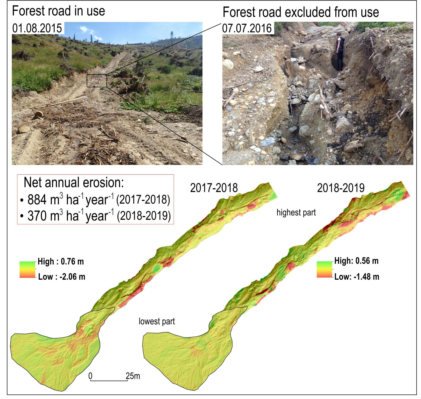
2. Study Area
3. Methods
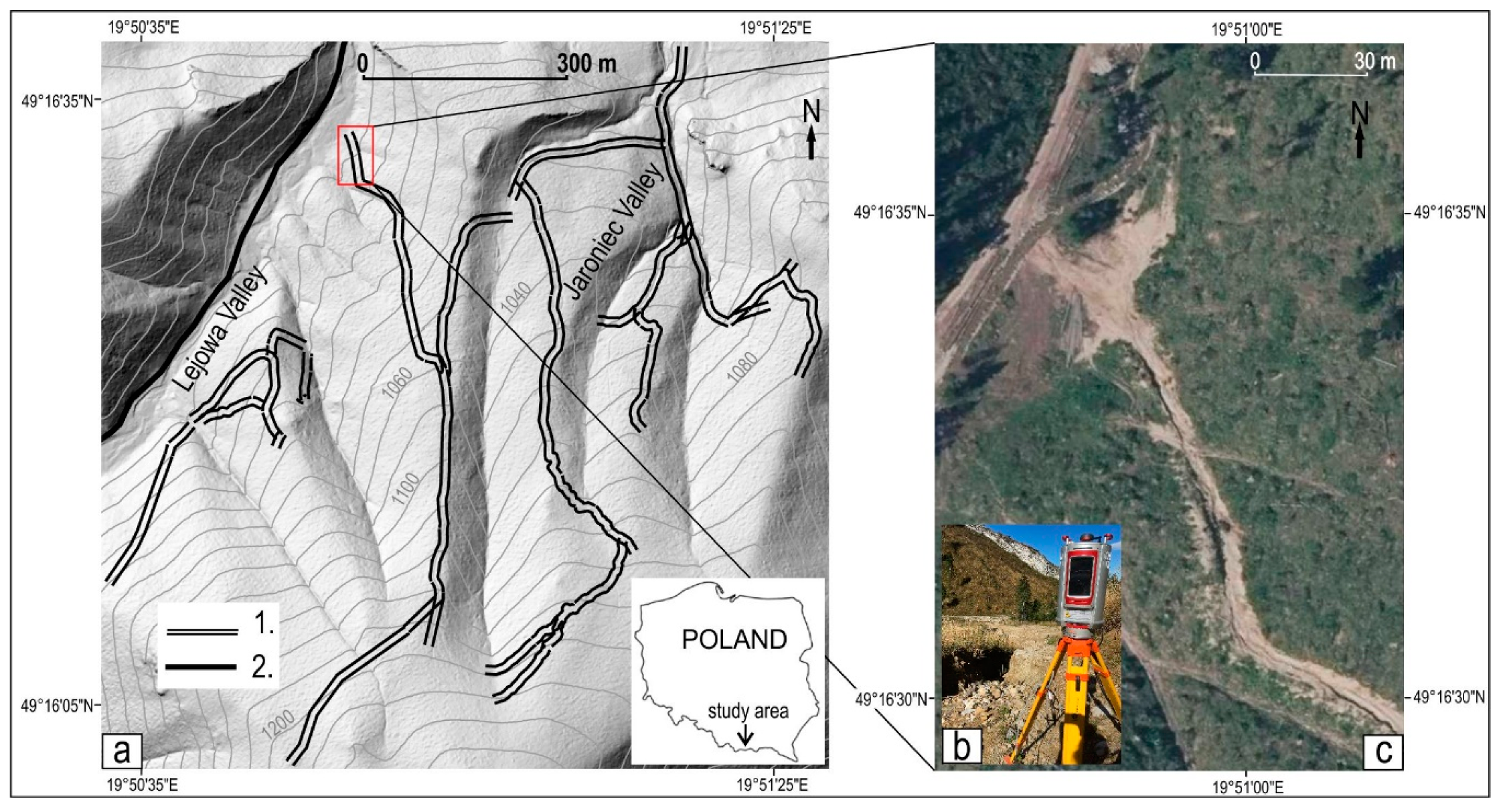
3.1. Analysis of Digital Elevation Models
3.2. Flow Velocities Analysis
4. Results
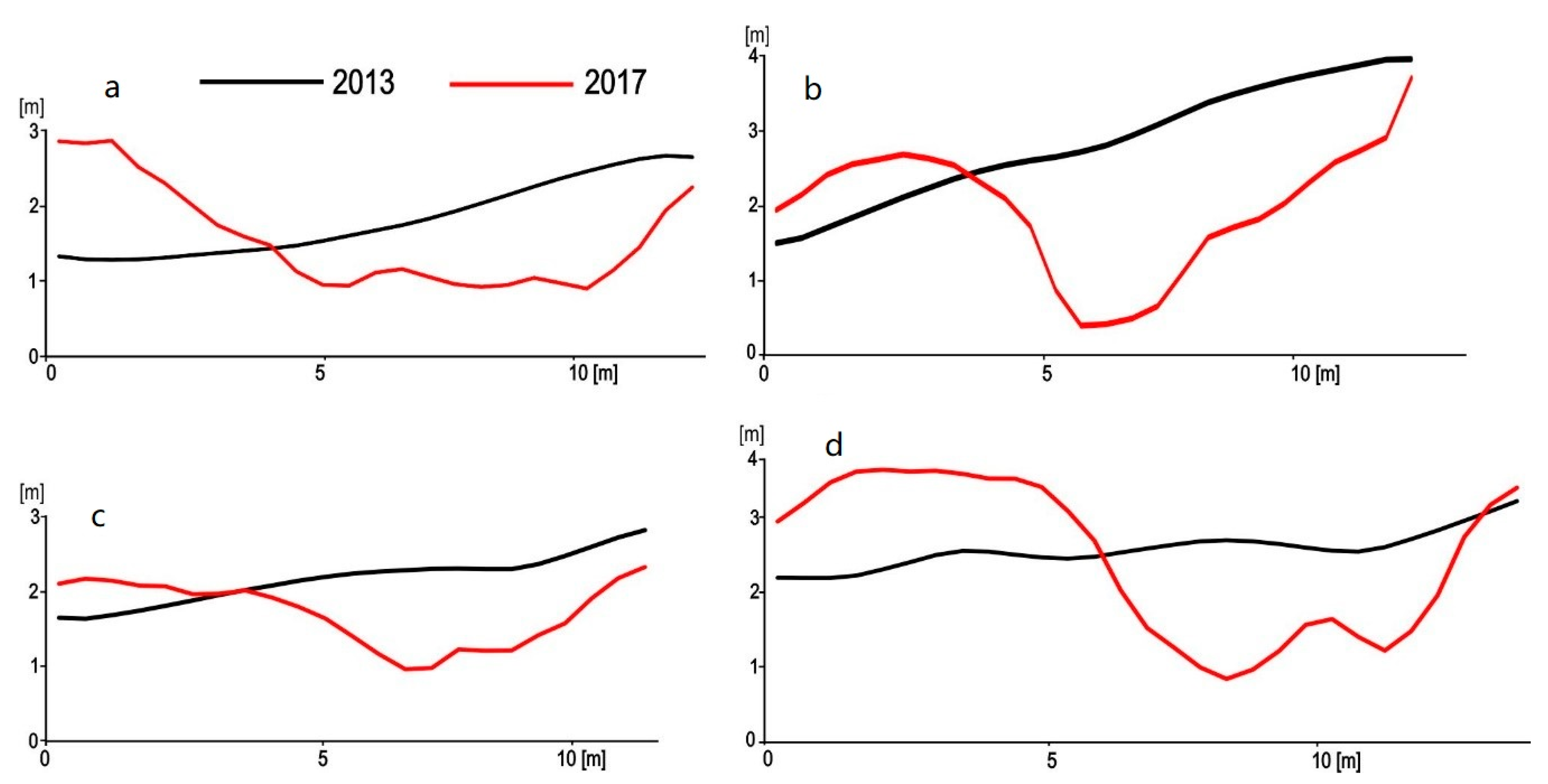
4.1. Changes at Cross-Section Profiles of the Forest Road in the Period 2013–2017
4.2. Changes at Cross-Section Profiles along the Forest Road in the Period 2017–2019
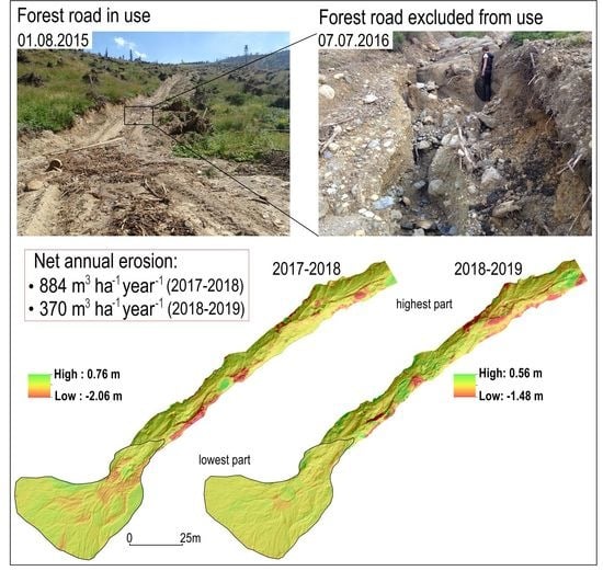
4.3. Rate of Erosion and Accumulation on the Studied Forest Road in the Years 2017–2019
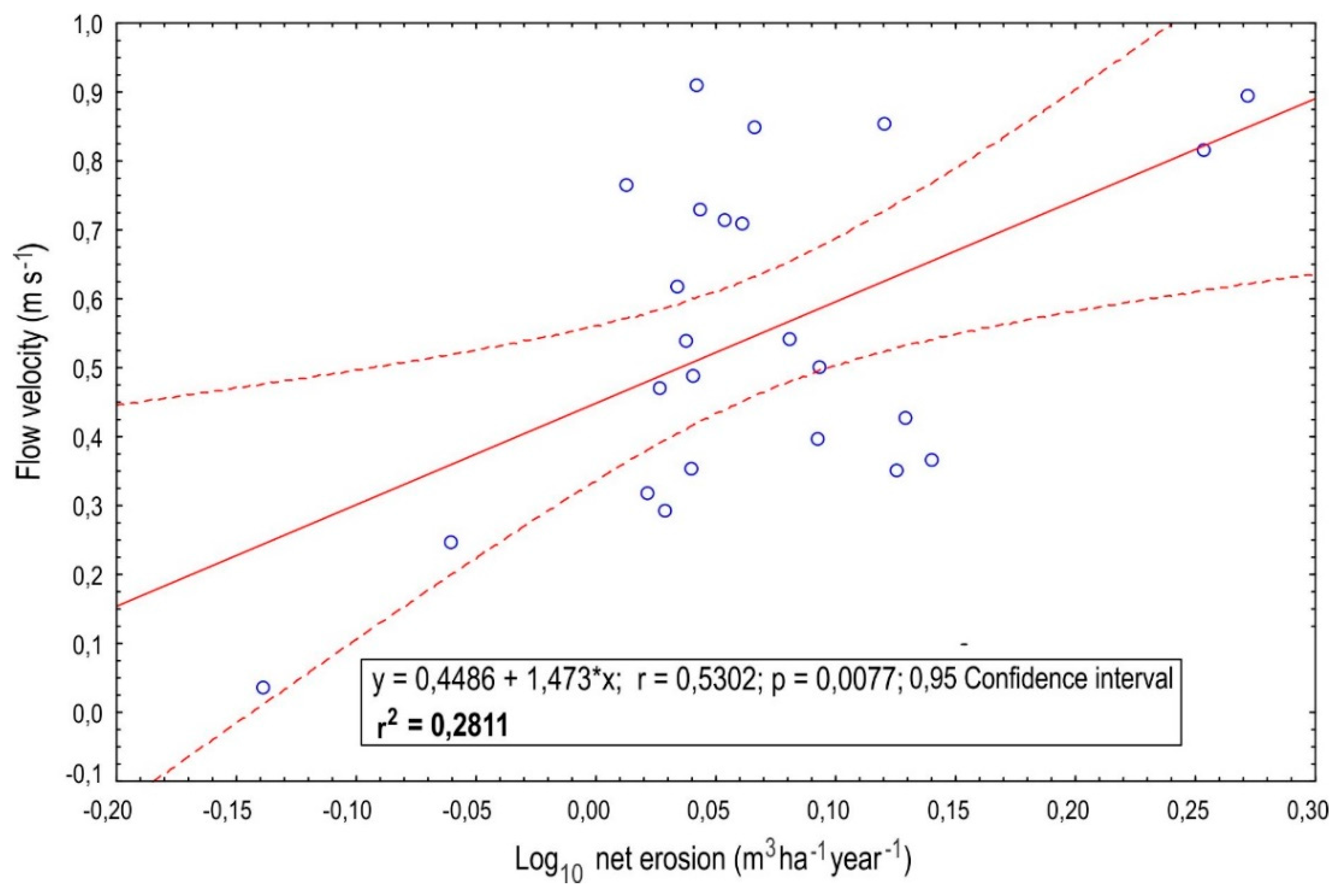
4.4. Relationship between Average Flow Velocity and Net Erosion
5. Discussion
5.1. Magnitude of Erosion within Forest Roads—Data Comparison
5.2. Flow Velocity Relationship—Data Comparison
5.3. Management Practices within Forest Roads—Selected Aspects
6. Conclusions
Author Contributions
Funding
Acknowledgments
Conflicts of Interest
Data Availability Statement
References
- Łukasik, W.; Kubiesa, P.; Staszewski, T. Erosion processes initialized by use of heavy equipment in mountain forests of the Wilczy Potok catchment, Silesian Beskids. Arch. Environ. Protect. 2016, 42, 80–86. [Google Scholar] [CrossRef] [Green Version]
- Cristan, R.; Aust, W.M.; Bolding, M.C.; Barrett, S.M.; Munsell, J.F.; Schilling, E. Effectiveness of forestry best management practices in the United States: Literature review. Forest Ecol. Manag. 2016, 360, 133–151. [Google Scholar] [CrossRef] [Green Version]
- Fidelus-Orzechowska, J.; Strzyżowski, D.; Żelazny, M. The geomorphic activity of forest roads and its dependencies in the Tatra Mountains. Geogr. Annal. Ser. A Phys. Geogr. 2018, 100, 59–74. [Google Scholar] [CrossRef]
- Reid, L.M.; Dunne, T.; Cederholm, C.J. Application of sediment budget studies to the evaluation of logging road impact. J. Hydrol. (N. Z.) 1981, 20, 49–62. [Google Scholar]
- Reid, L.M.; Dunne, T. Sediment production from forest road surfaces. Water Resour. Res. 1984, 20, 1753–1761. [Google Scholar] [CrossRef] [Green Version]
- Baharuddin, K.; Mokhtaruddin, A.M.; Muhamad, M.N. Surface runoff and soil loss from a skid trail and a logging road in a tropical forest. J. Trop. For. Sci. 1995, 7, 558–569. [Google Scholar]
- Sidle, C.R.; Sasaki, S.; Otsuki, M.; Noguchi, S.; Nik, A.R. Sediment pathways in a tropical forest: Effects of logging roads and skid trails. Hydrol. Process. 2004, 18, 703–720. [Google Scholar] [CrossRef]
- Negishi, J.N.; Sidle, R.C.; Ziegler, A.D.; Noguchi, S.; Rahim, N.A. Contribution of intercepted subsurface flow to road runoff and sediment transport in a logging-disturbed tropical catchment. Earth Surf. Process. Landf. J. Br. Geomorphol. Res. Group 2008, 33, 1174–1191. [Google Scholar] [CrossRef]
- Dutton, A.L.; Loague, K.; Wemple, B.C. Simulated effect of a forest road on near-surface hydrologic response and slope stability. Earth Surf. Process. Landf. J. Br. Geomorphol. Res. Group 2005, 30, 325–338. [Google Scholar] [CrossRef]
- Soulis, K.X.; Dercas, N.; Papadaki, C.H. Effects of forest roads on the hydrological response of a small-scale mountain watershed in Greece. Hydrol. Process. 2015, 29, 1772–1782. [Google Scholar] [CrossRef]
- Thomaz, E.L.; Peretto, G.T. Hydrogeomorphic connectivity on roads crossing in rural headwaters and its effect on stream dynamics. Sci. Total Environ. 2016, 550, 547–555. [Google Scholar] [CrossRef]
- Kasprzak, M. Tempo degradacji powierzchni dróg i ścieżek turystycznych w Karkonoszach Wschodnich [The rate of degradation of tourist routes in the East Gian mountains]. Opera Corcon. 2005, 42, 17–30. [Google Scholar]
- Wałdykowski, P.; Krzemień, K. The role of road and footpath networks in shaping the relief of middle mountains on the example of the Gorce Mountains (Poland). Z. Geomorphol. 2013, 57, 429–470. [Google Scholar] [CrossRef]
- Wemple, C.B.; Swanson, J.F.; Jones, J.A. Forest roads and geomorphic processes interactions, Cascade Range, Oregon. Earth Surf. Process. Landf. 2001, 26, 191–204. [Google Scholar] [CrossRef]
- Borga, M.; Tonelli, F.; Selleroni, J. A physically based model of the effects of forest roads on slope stability. Water Resour. Res. 2004, 40, 1–9. [Google Scholar] [CrossRef] [Green Version]
- Borga, M.; Tonelli, F.; Dalla Fontana, G.; Cazorzi, F. Evaluating the influence of forest roads on shallow landsliding. Ecol. Modell. 2005, 187, 85–98. [Google Scholar] [CrossRef]
- Safari, A.; Kavian, A.; Parsakhoo, A.; Saleh, I.; Jordán, A. Impact of different parts of skid trails on runoff and soil erosion in the Hyrcanian forest (northern Iran). Geoderma 2016, 263, 161–167. [Google Scholar] [CrossRef]
- Kleinschroth, F.; Healey, J.R. Impacts of logging roads on tropical forests. Biotropica 2017, 49, 620–635. [Google Scholar] [CrossRef]
- Demir, M. Impacts, management and functional planning criterion of forest road network system in Turkey. Transp. Res. Part A Policy Practice 2007, 41, 56–68. [Google Scholar] [CrossRef]
- Tittler, R.; Messier, C.; Fall, A. Concentrating anthropogenic disturbance to balance ecological and economic values: Applications to forest management. Ecol. Appl. 2012, 22, 1268–1277. [Google Scholar] [CrossRef]
- Ioraş, F.; Muica, N.; Turnock, D. Approaches to sustainable forestry in the Piatra Craiului National Park. GeoJournal 2001, 55, 579–598. [Google Scholar] [CrossRef]
- Kräuchi, N.; Brang, P.; Schönenberger, W. Forests of mountainous regions: Gaps in knowledge and research needs. For. Ecol. Manag. 2000, 132, 73–82. [Google Scholar] [CrossRef]
- Tarolli, P.; Calligaro, S.; Cazorzi, F.; Fontana, G.D. Recognition of surface flow processes influenced by roads and trails in mountain areas using high-resolution topography. Eur. J. Remote Sens. 2013, 46, 176–197. [Google Scholar] [CrossRef]
- Dąbek, P.B.; Patrzałek, C.; Ćmielewski, B.; Żmuda, R. The use of terrestrial laser scanning in monitoring and analyses of erosion phenomena in natural and anthropogenically transformed areas. Cogent Geosci. 2018, 4, 1437684. [Google Scholar] [CrossRef]
- Dąbek, P.B.; Żmuda, R.; Szczepański, J.; Ćmielewski, B. Evaluation of water soil erosion processes in forest areas in the Western Sudetes using terrestrial laser scanning and GIS tools. E3S Web Conf. 2018, 44, 26. [Google Scholar] [CrossRef]
- Yurtseven, H.; Akgul, M.; Akay, A.O.; Akburak, S.; Cigizoglu, H.K.; Demir, M.; Ozturk, T.; Eksi, M. High accuracy monitoring system to estimate forest road surface degradation on horizontal curves. Environ. Monit. Assess. 2019, 191, 1–17. [Google Scholar] [CrossRef] [PubMed]
- Dąbek, P.; Żmuda, R.; Ćmielewski, B.; Szczepański, J. Analysis of water erosion processes using terrestrial laser scanning. Acta Geodynam. Geomater. 2014, 11, 45–52. [Google Scholar] [CrossRef] [Green Version]
- Akgul, M.; Yurtseven, H.; Akburak, S.; Demir, M.; Cigizoglu, H.K.; Ozturk, T.; Eksi, M.; Akay, A.O. Short term monitoring of forest road pavement degradation using terrestrial laser scanning. Measurement 2017, 103, 283–293. [Google Scholar] [CrossRef]
- Akay, A.O.; Akgul, M.; Demir, M. Determination of temporal changes on forest road pavement with terrestrial laser scanner. Fresenius Environ. Bull. 2018, 27, 1437–1448. [Google Scholar]
- Ferraz, A.; Mallet, C.; Chehata, N. Large-scale road detection in forested mountainous areas using airborne topographic lidar data. ISPRS J. Photogramm. Remote Sens. 2016, 112, 23–36. [Google Scholar] [CrossRef]
- Affek, A.N.; Zachwatowicz, M.; Sosnowska, A.; Gerlée, A.; Kiszka, K. Impacts of modern mechanised skidding on the natural and cultural heritage of the Polish Carpathian Mountains. For. Ecol. Manag. 2017, 405, 391–403. [Google Scholar] [CrossRef]
- Miller, J.R.; Joyce, L.A.; Knight, R.L.; King, R.M. Forest roads and landscape structure in the southern Rocky Mountains. Landsc. Ecol. 1996, 11, 115–127. [Google Scholar] [CrossRef]
- Lugo, A.E.; Gucinski, H. Function, effects, and management of forest roads. For. Ecol. Manag. 2000, 133, 249–262. [Google Scholar] [CrossRef]
- Strzyżowski, D.; Fidelus, J.; Żelazny, M. Sediment transport by uprooting in the forested part of the Tatra Mountains, southern Poland. Catena 2018, 160, 329–338. [Google Scholar] [CrossRef]
- Ustrnul, Z.; Walawender, E.; Czekierda, D.; Šťastný, P.; Lapin, M.; Mikulová, K. Opady atmosferyczne i pokrywa śnieżna. In Atlas Tatr. Przyroda Nieożywiona: II.3; Tatrzański Park Narodowy: Zakopane, Poland, 2015; ISBN 978-83-61788-91-1. [Google Scholar]
- Hess, M. Piętra klimatyczne Tatr [Climatic zones in the Tatra Mountains]. Czas. Geogr. 1974, 45, 75–93. [Google Scholar]
- Żmudzka, E.; Nejedlík, P.; Mikulová, K. Temperatura, wskaźniki termiczne. In Atlas Tatr. Przyroda nieożywiona: II.2; Tatrzański Park Narodowy: Zakopane, Poland, 2015; ISBN 978-83-61788-91-1. [Google Scholar]
- Chow, V.T. Open-Channel Hydraulics; Mc-Graw-Hill: New York, NY, USA, 1959. [Google Scholar]
- Ramos-Scharrón, C.E.; MacDonald, L.H. Measurement and prediction of natural and anthropogenic sediment sources, St. John, US Virgin Islands. Catena 2007, 71, 250–266. [Google Scholar] [CrossRef]
- MacDonald, L.H.; Coe, D.B. Road sediment production and delivery: Processes and management. In Proceedings of the First World Landslide Forum, International Programme on Landslides and International Strategy for Disaster Reduction, Tokyo, Japan, 18–21 November 2008; pp. 381–384. [Google Scholar]
- Scharrón, C.E.R. Sediment production from unpaved roads in a sub-tropical dry setting—Southwestern Puerto Rico. Catena 2010, 82, 146–158. [Google Scholar] [CrossRef]
- Zemke, J.J. Runoff and soil erosion assessment on forest roads using a small scale rainfall simulator. Hydrology 2016, 3, 25. [Google Scholar] [CrossRef] [Green Version]
- Bodoque, J.M.; Díez-Herrero, A.; Martín-Duque, J.F.; Rubiales, J.M.; Godfrey, A.; Pedraza, J.; Carrasco, R.M.; Sanz, M.A. Sheet erosion rates determined by using dendrogeomorphological analysis of exposed tree roots: Two examples from Central Spain. Catena 2005, 64, 81–102. [Google Scholar] [CrossRef] [Green Version]
- Midriak, R. Quantitative analysis of natural hazards in the eastern part of the Slovak Tatra mountains and their foreland. Stud. Geomorphol. Carpatho-Balc. 2017, 51/52, 139–154. [Google Scholar]
- Tomczyk, A.M.; Ewertowski, M. Quantifying short-term surface changes on recreational trails: The use of topographic surveys and ‘digital elevation models of differences’(DODs). Geomorphology 2013, 183, 58–72. [Google Scholar] [CrossRef] [Green Version]
- Midriak, R. Present-day retreat of slopes above the upper timberline in the Slovak part of the Western Carpathians. Geogr. Polonica 2008, 81, 93–100. [Google Scholar]
- Lepeška, T. Dynamics of development and variability of surface degradation in the subalpine and alpine zones (an example from the Velká Fatra Mts., Slovakia). Open Geosci. 2016, 8, 771–786. [Google Scholar] [CrossRef]
- Rączkowska, Z. Nivation in the high Tatras, Poland. Geogr. Annal. Ser. A Phys. Geogr. 1995, 77, 251–258. [Google Scholar] [CrossRef]
- Raczkowska, Z. Nivation and its geomorphic significance—Examples from the Polish High Tatra and the Ortles-Cevedale Massif, the Italian Alps. Stud. Geomorphol. Carpatho-Balc. 1997, 31, 175–192. [Google Scholar]
- Pearce, A.J.; Hodgkiss, P.D. Erosion and sediment yield from a landing failure after a moderate rainstorm, Tairua Forest. N. Z. J. For. 1987, 32, 19–22. [Google Scholar]
- Gerrard, A.J. Mountain Environment: An Examination of the Physical Geography of Mountains; Belhaven Press: London, UK, 1970; p. 317. [Google Scholar]
- Parzóch, K. Procesy erozyjne na stokach wylesionych w Karkonoszach [Erosion processes on deforested slopes in the Karkonosze Mts]. Zesz. Probl. Postęp. Nauk Rol. 2002, 487, 239–247. [Google Scholar]
- Bryndal, T.; Kroczak, R. Reconstruction and characterization of the surface drainage system functioning during extreme rainfall: The analysis with use of the ALS-LIDAR data—The case study in two small flysch catchments (Outer Carpathian, Poland). Environ. Earth Sci. 2019, 78, 215. [Google Scholar] [CrossRef] [Green Version]
- Figuła, K. Preliminary assessment of erosion on the several districts of the Krakowskie province. Rocz. Nauk Rol. 1955, 1, 1–80. [Google Scholar]
- Bryndal, T.; Franczak, P.; Kroczak, R.; Cabaj, W.; Kołodziej, A. The impact of extreme rainfall and flash floods on the flood risk management process and geomorphological changes in small Carpathian catchments: A case study of the Kasiniczanka river (Outer Carpathians, Poland). Nat. Hazards 2017, 88, 95–120. [Google Scholar] [CrossRef]
- Byblyuk, N.; Styranivsky, O.; Korzhov, V.; Kudra, V. Timber harvesting in the Ukrainian Carpathians: Ecological problems and methods to solve them. J. For. Sci. 2010, 56, 333–340. [Google Scholar] [CrossRef] [Green Version]
- Akbarimehr, M.; Naghdi, R. Reducing erosion from forest roads and skid trails by management practices. J. For. Sci. 2012, 58, 165–169. [Google Scholar] [CrossRef] [Green Version]
- Sidle, R.C.; Ziegler, A.D.; Negishi, J.N.; Nik, A.R.; Siew, R.; Turkelboom, F. Erosion processes in steep terrain—truths, myths, and uncertainties related to forest management in Southeast Asia. For. Ecol. Manag. 2006, 224, 199–225. [Google Scholar] [CrossRef]
- Croke, J.; Hairsine, P.; Fogarty, P. Soil recovery from track construction and harvesting changes in surface infiltration, erosion and delivery rates with time. For. Ecol. Manag. 2001, 143, 3–12. [Google Scholar] [CrossRef]
- Megahan, W.F.; Wilson, M.; Monsen, S.B. Sediment production from granitic cutslopes on forest roads in Idaho, USA. Earth Surf. Process. Landf. 2001, 26, 153–163. [Google Scholar] [CrossRef]
- Sidle, R.C.; Furuichi, T.; Kono, Y. Unprecedented rates of landslide and surface erosion along a newly constructed road in Yunnan, China. Nat. Hazards 2011, 57, 313–326. [Google Scholar] [CrossRef]
- Abdi, E.; Majnounian, B.; Darvishsefat, A.; Mashayekhi, Z.; Sessions, J. A GIS-MCE based model for forest road planning. J. For. Sci. 2009, 55, 171–176. [Google Scholar] [CrossRef] [Green Version]
- Jaafari, A.; Najafi, A.; Rezaeian, J.; Sattarian, A.; Ghajar, I. Planning road networks in landslide-prone areas: A case study from the northern forests of Iran. Land Use Policy 2015, 47, 198–208. [Google Scholar] [CrossRef]
- Košir, B.; Krč, J. Where to Place and Build Forest Roads-Experience from the Model. J. For. Eng. 2000, 11, 7–19. [Google Scholar]
- Enache, A.; Kühmaier, M.; Visser, R.; Stampfer, K. Forestry operations in the European mountains: A study of current practices and efficiency gaps. Scand. J. For. Res. 2016, 31, 412–427. [Google Scholar] [CrossRef]
- Lewis, S.L.; Edwards, D.P.; Galbraith, D. Increasing human dominance of tropical forests. Science 2015, 349, 827–832. [Google Scholar] [CrossRef] [PubMed]
- Swift, L.W. Forest access roads: Design, maintenance, and soil loss. In Forest Hydrology and Ecology at Coweeta; Springer: New York, NY, USA, 1988; pp. 313–324. [Google Scholar]
- Burroughs, E.R., Jr.; King, J.G. Reduction of Soil Erosion on Forest Roads; USDA Forest Service: Washinghton, DC, USA; UNL Faculty Publications: Lincoln, NE, USA, 1989; pp. 1–22. [Google Scholar]
- Yousefi, S.; Moradi, H.; Boll, J.; Schönbrodt-Stitt, S. Effects of road construction on soil degradation and nutrient transport in Caspian Hyrcanian mixed forests. Geoderma 2016, 284, 103–112. [Google Scholar] [CrossRef]


| Year | Precipitation (mm) | |
|---|---|---|
| Annual Value | from June to September | |
| 2017 | 1318.7 | 678.9 |
| 2018 | 1196.2 | 824.7 |
| 2019 | 950.6 | 401.7 |
| Net Change a | Study Area | Author(s) | |
|---|---|---|---|
| (cm year−1) | |||
| Form of Human Impact | |||
| Forest road (first year without human impact) | −9 (average) | Tatra Mts. (Poland) | Our research |
| Forest road (second year without human impact) | −4.4 (average) | Tatra Mts. (Poland) | Our research |
| Forest road | −4.5 (average) | Tatra Mts. (Poland) | [3] |
| Forest roads | from −0.08 to −4.14 | Gorce Mts. (Poland) | [13] |
| Tourist trail | from −2.3 to +2.5 −0.7 (average) −0.9 (average) | Gorce Mts. (Poland) | [45] |
| Tourist trail above timberline | from −0.59 to −2.66 −1.38 (average) | Western Carpathian Mts. (Slovakia) | [46] |
| Natural Processes and Landforms | |||
| Gully erosion Water erosion above timberline | from −0.88 to −2.66 from +0.012 to +0.072 | Tatra Mts. and their foreland (Slovakia) High Tatra Mts., Belianske Tatra Mts. (Slovakia) | [44] |
| Avalanche chutes | −2.4 (average) | Veľká Fatra Mts., (Slovakia) | [47] |
| Surface runoff | +0.893 (average) | Western Tatra Mts. (Slovakia) | [46] |
| Nival niches | from −1 to −5 | High Tatra Mts. (Poland) | [48,49] |
Publisher’s Note: MDPI stays neutral with regard to jurisdictional claims in published maps and institutional affiliations. |
© 2020 by the authors. Licensee MDPI, Basel, Switzerland. This article is an open access article distributed under the terms and conditions of the Creative Commons Attribution (CC BY) license (http://creativecommons.org/licenses/by/4.0/).
Share and Cite
Fidelus-Orzechowska, J.; Strzyżowski, D.; Cebulski, J.; Wrońska-Wałach, D. A Quantitative Analysis of Surface Changes on an Abandoned Forest Road in the Lejowa Valley (Tatra Mountains, Poland). Remote Sens. 2020, 12, 3467. https://0-doi-org.brum.beds.ac.uk/10.3390/rs12203467
Fidelus-Orzechowska J, Strzyżowski D, Cebulski J, Wrońska-Wałach D. A Quantitative Analysis of Surface Changes on an Abandoned Forest Road in the Lejowa Valley (Tatra Mountains, Poland). Remote Sensing. 2020; 12(20):3467. https://0-doi-org.brum.beds.ac.uk/10.3390/rs12203467
Chicago/Turabian StyleFidelus-Orzechowska, Joanna, Dariusz Strzyżowski, Jarosław Cebulski, and Dominika Wrońska-Wałach. 2020. "A Quantitative Analysis of Surface Changes on an Abandoned Forest Road in the Lejowa Valley (Tatra Mountains, Poland)" Remote Sensing 12, no. 20: 3467. https://0-doi-org.brum.beds.ac.uk/10.3390/rs12203467