The Lavic Lake Fault: A Long-Term Cumulative Slip Analysis via Combined Field Work and Thermal Infrared Hyperspectral Airborne Remote Sensing

 , , ,
, , ,
Abstract
:
1. Introduction
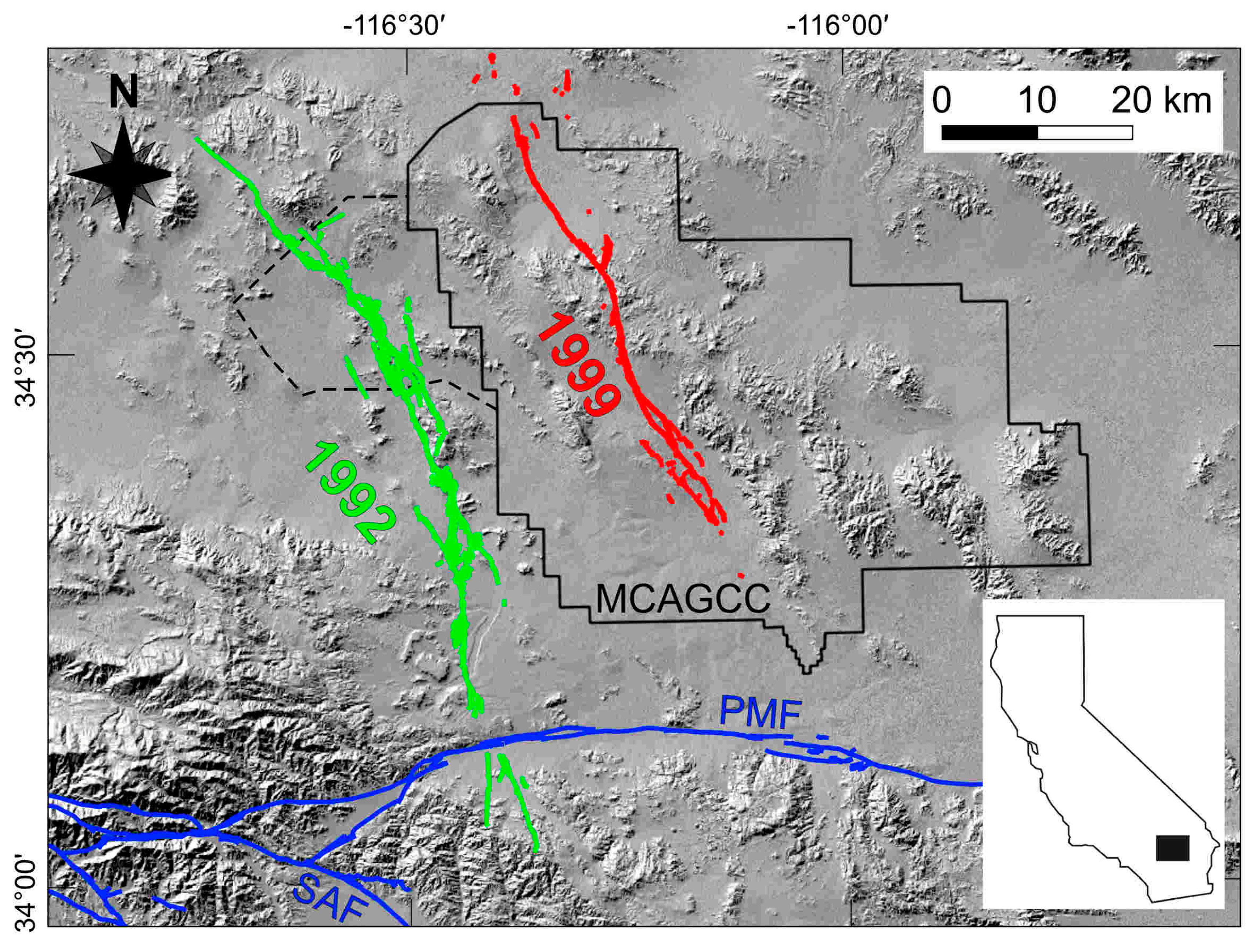
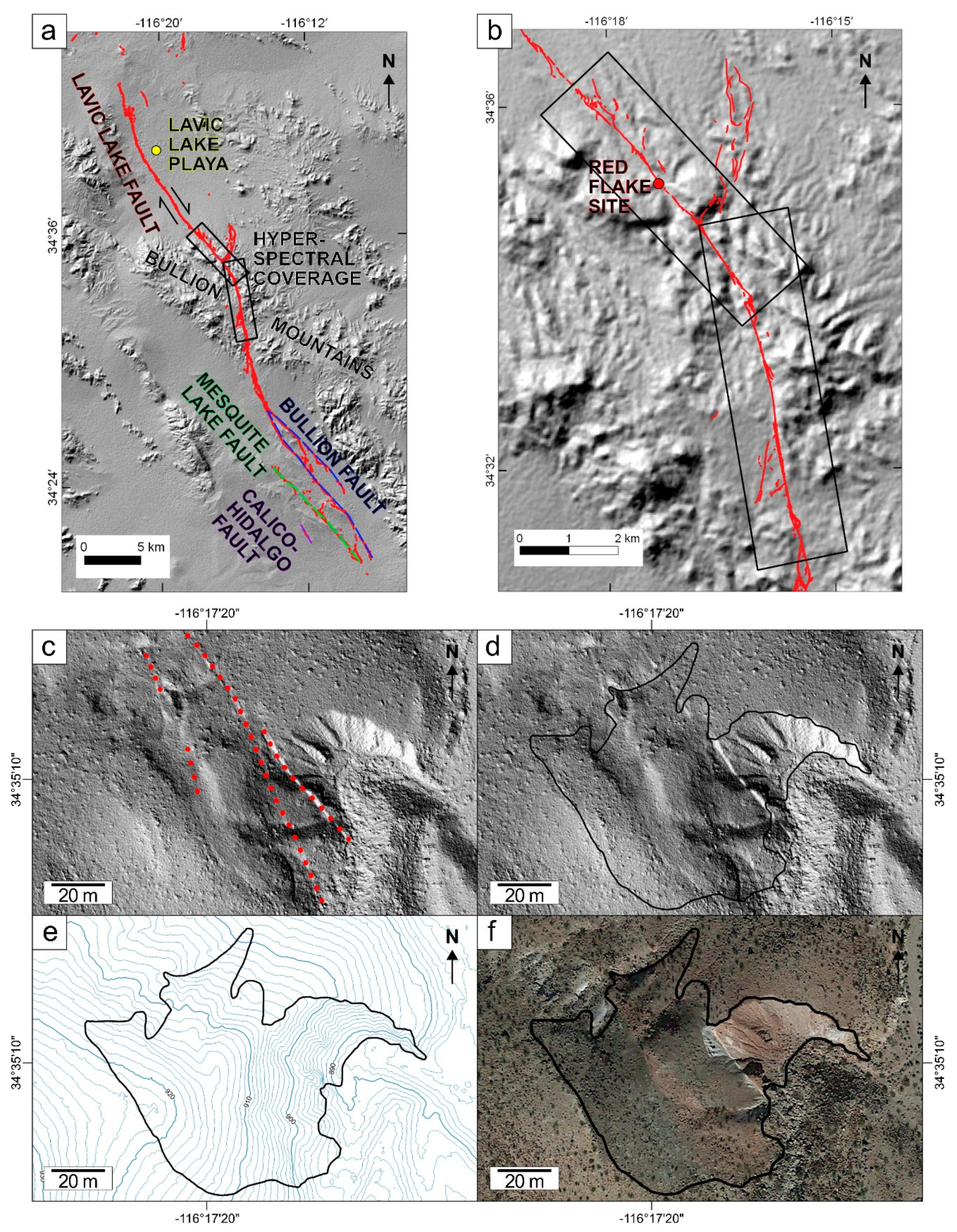
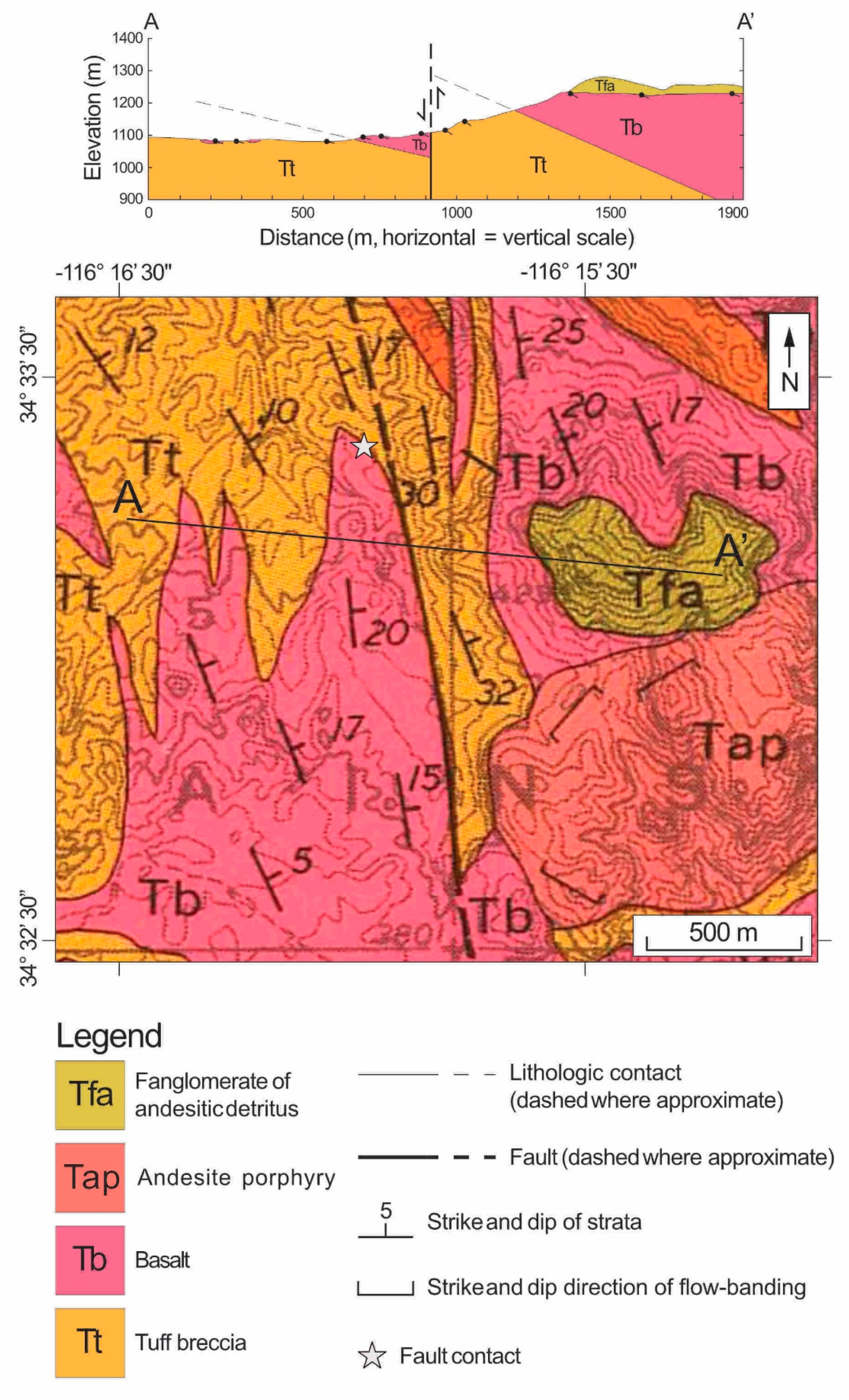
2. Geologic Setting
3. Materials and Methods
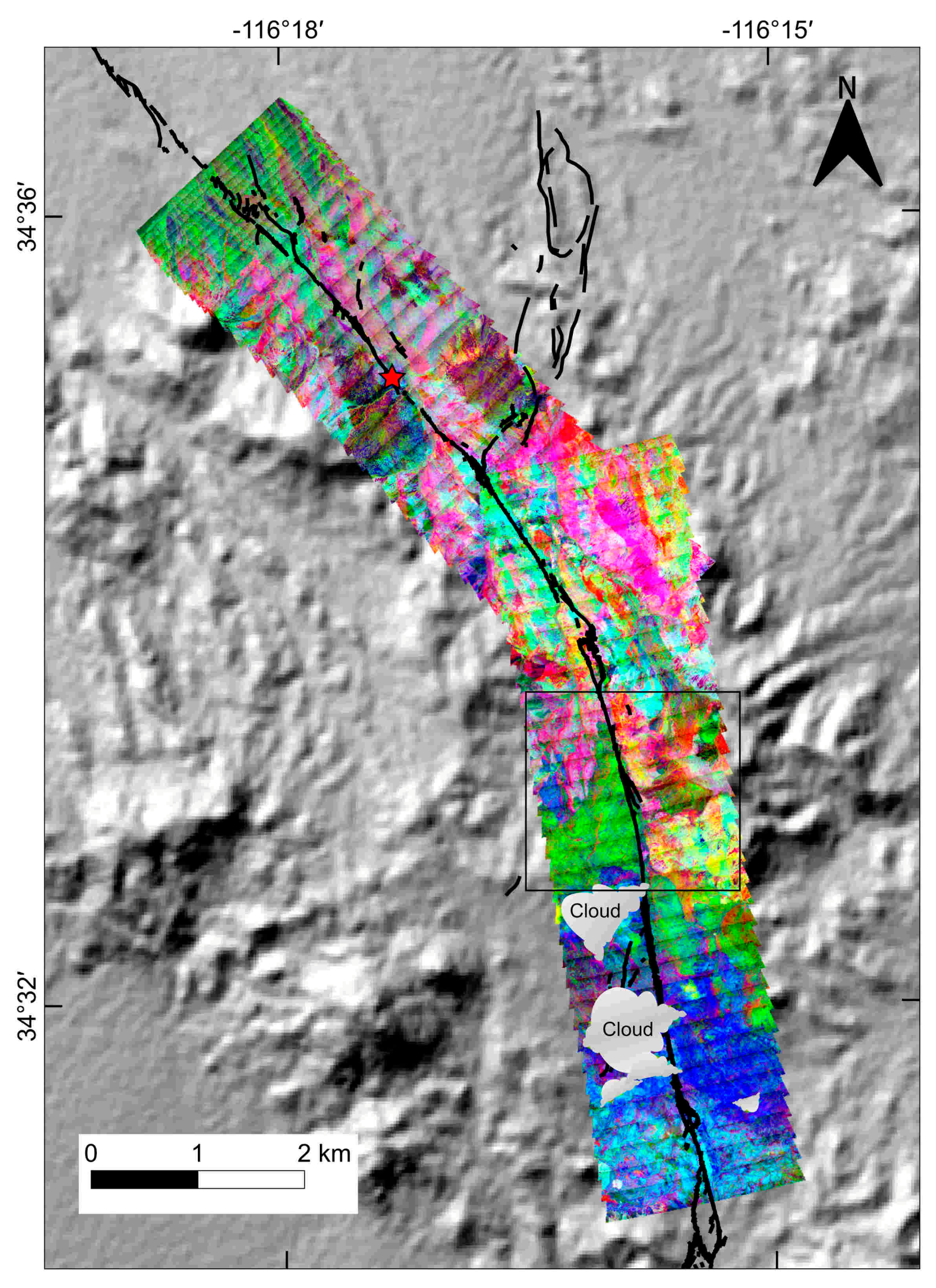
3.1. Hyperspectral Data Collection
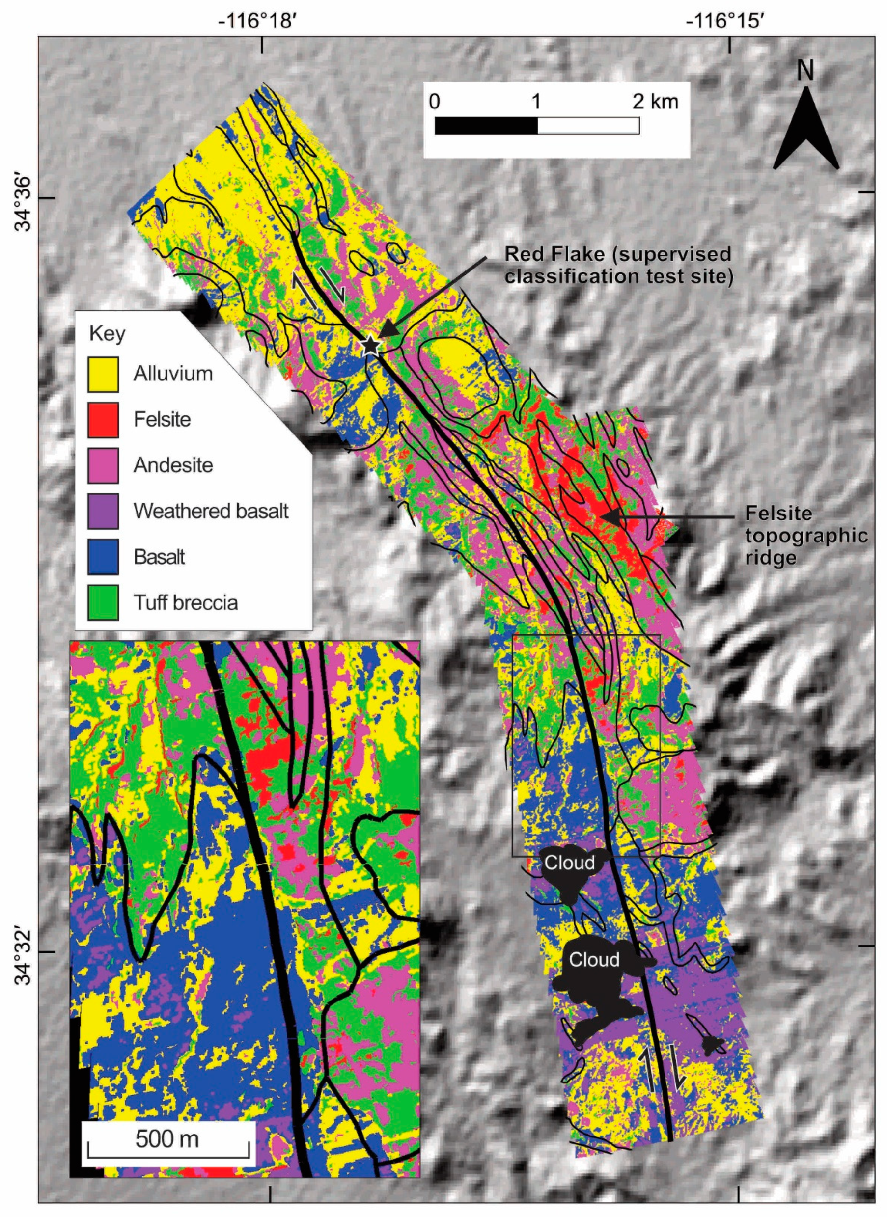
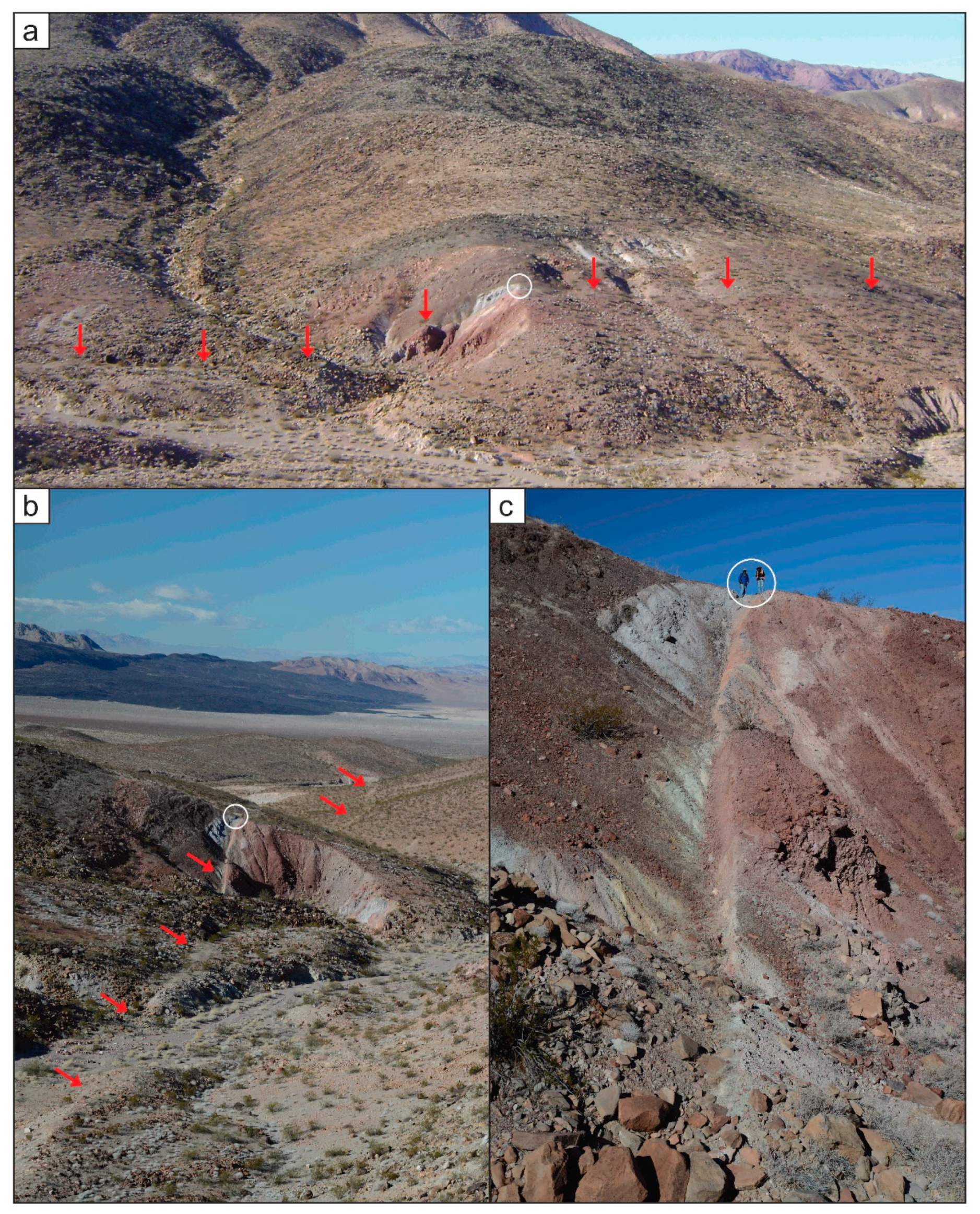
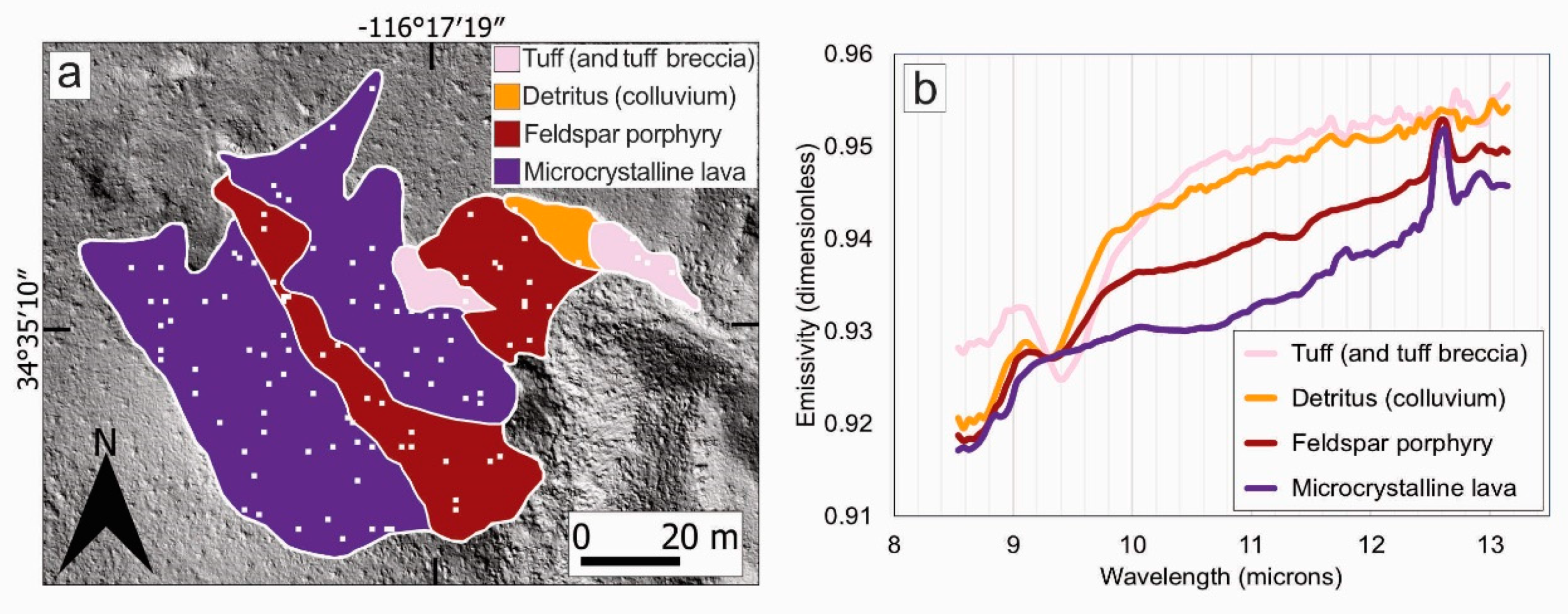
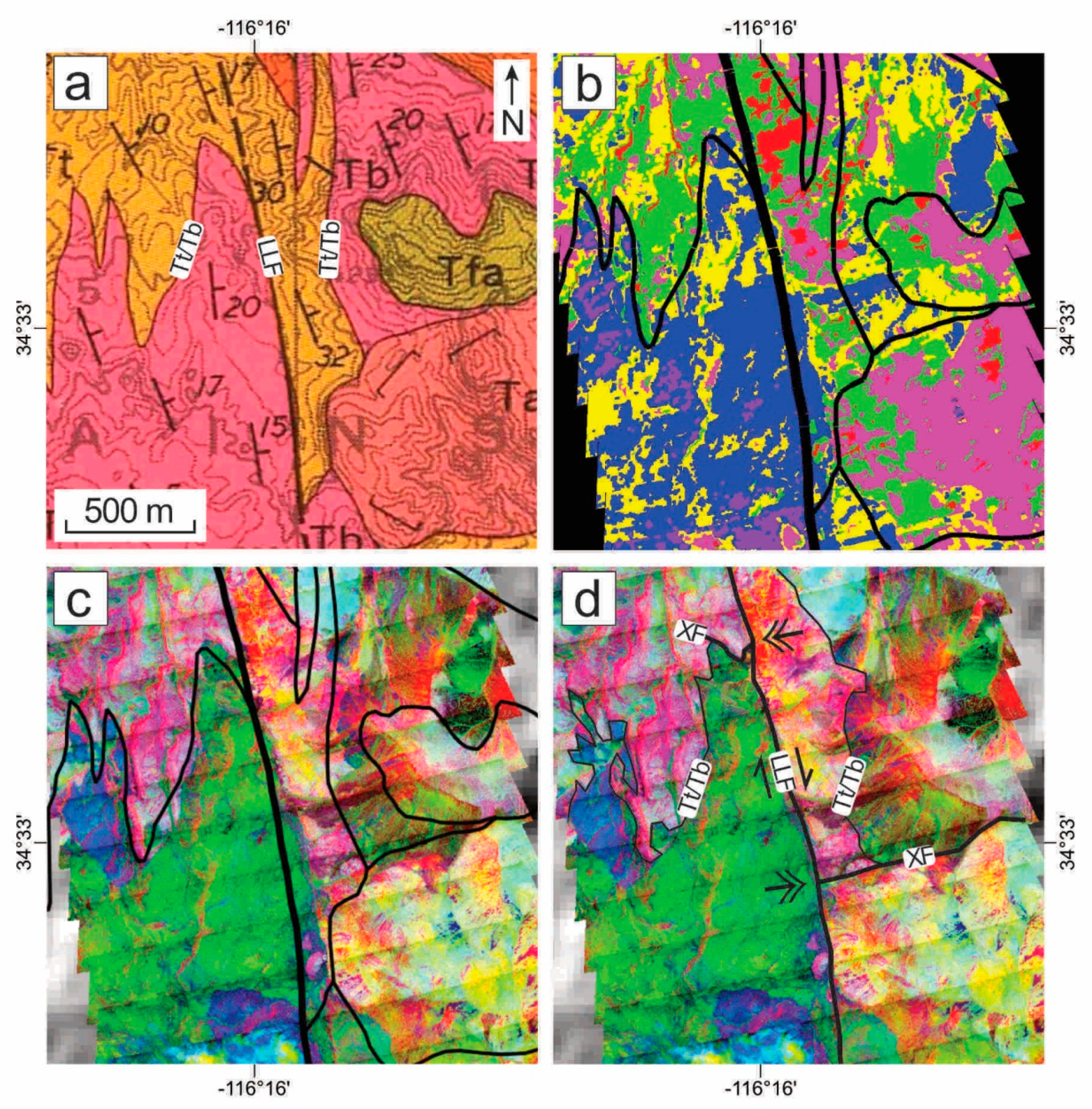
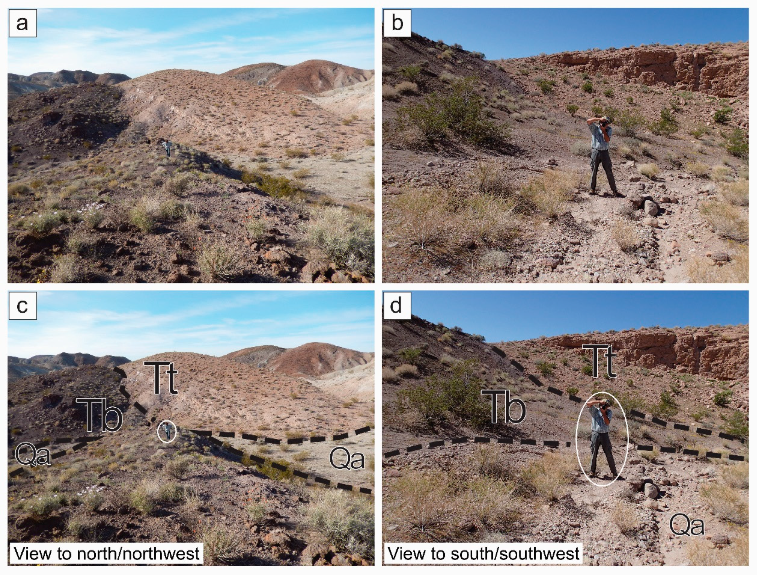
3.2. Ground Truth Field Mapping of the Red Flake Site
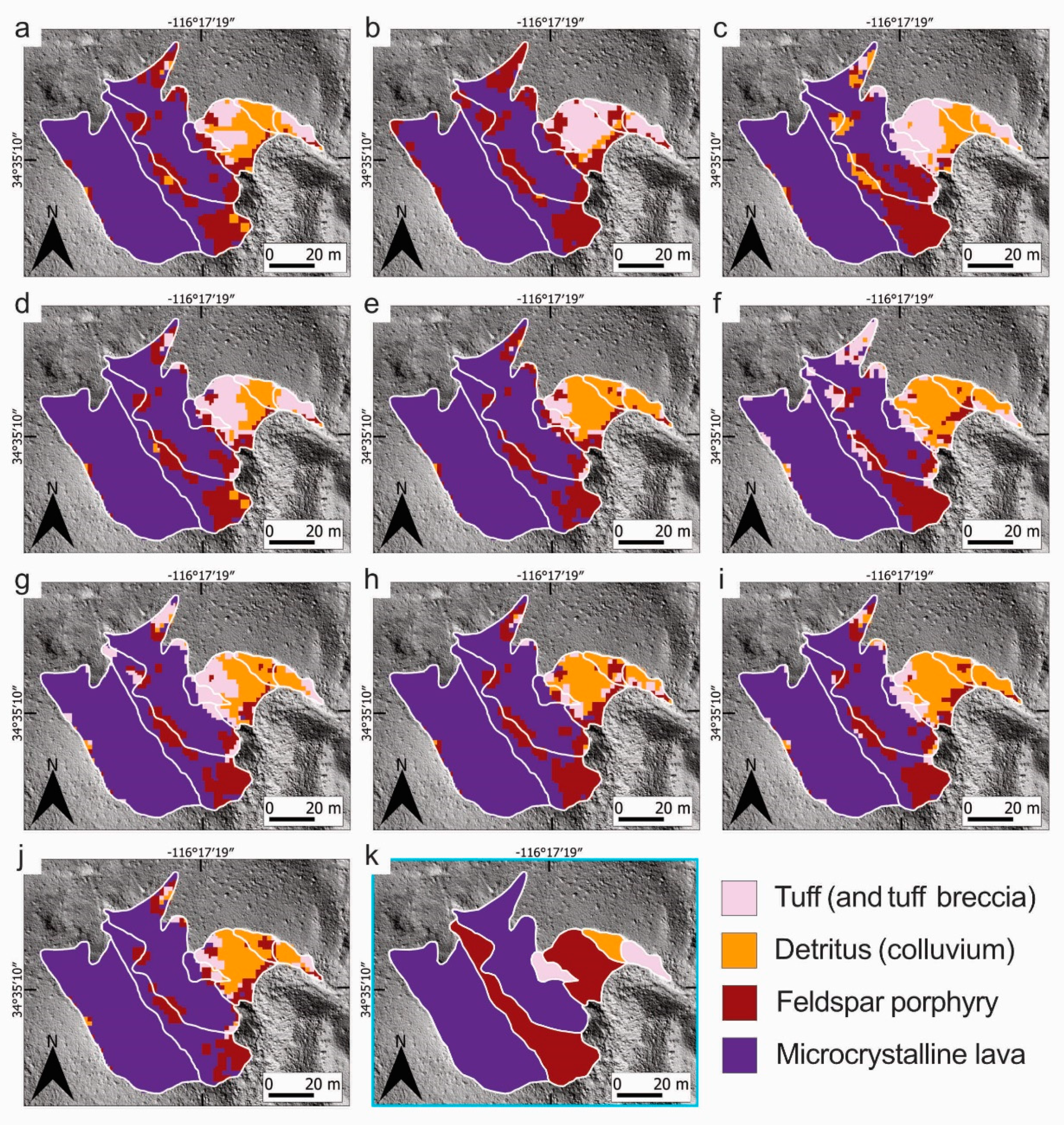
3.3. Supervised and Unsupervised Classifications of the Airborne Hyperspectral Imagery
4. Results
5. Discussion
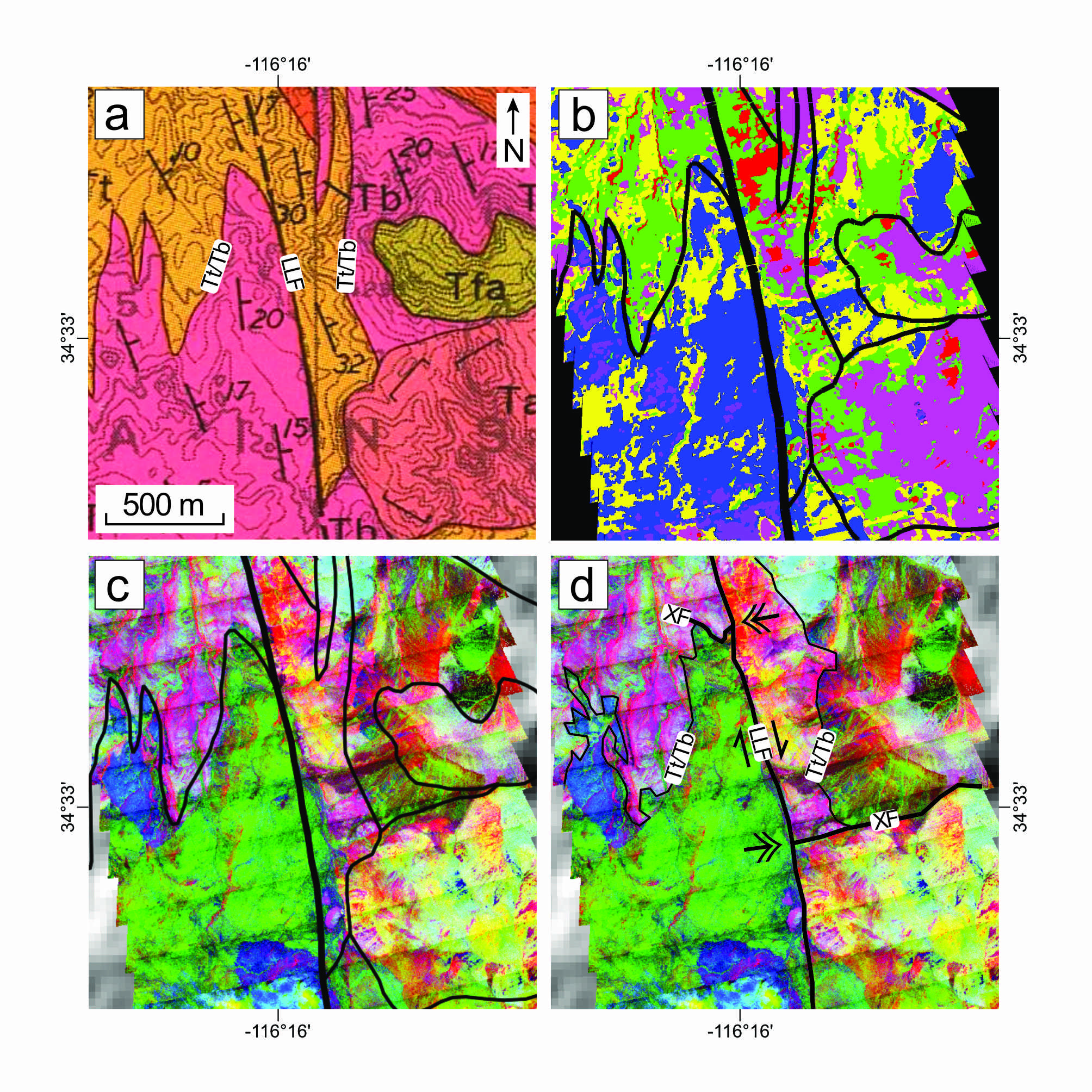
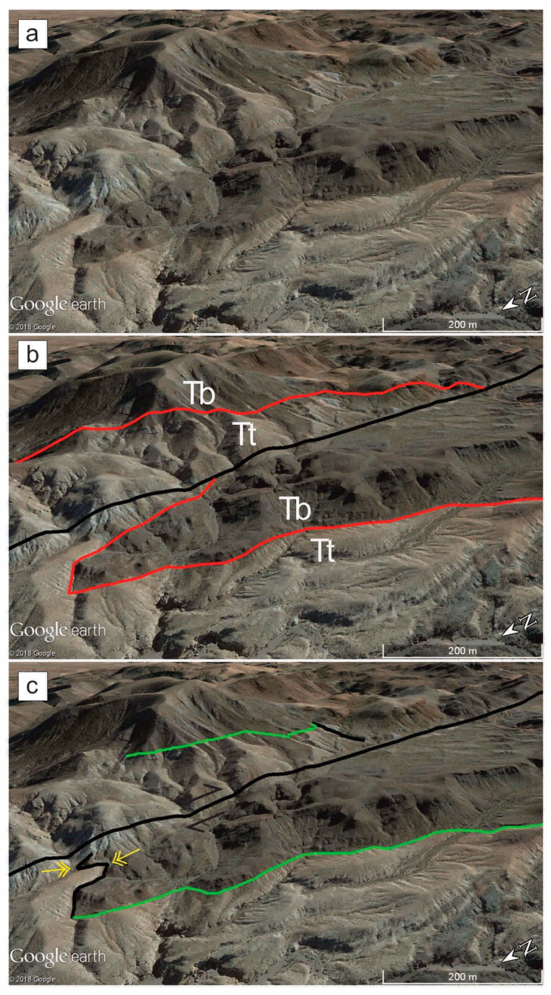
5.1. Displaced Features
5.1.1. Tt/Tb Contact
5.1.2. Cross Fault
5.2. On-Fault Net Slip and Off-Fault Deformation
5.3. Implications for Estimates of Slip Rate on the Lavic Lake Fault
6. Conclusions
- Hyperspectral-airborne-image geologic maps of a test site along the 1999 Hector Mine earthquake surface rupture are accurate to 71 ± 1%
- The net slip along the Lavic Lake fault is 1036 +27/−26 m, which increases the horizontal component to 1276 +18/−22 m by incorporating off-fault deformation
- The estimated long-term slip rate is <4 mm/yr, which does not raise the sum geologic ECSZ rate to present-day geodetic values
Author Contributions
Funding
Acknowledgments
Conflicts of Interest
Appendix A
Appendix A.1. Background on Supervised Classifications and How They Were Applied to This Study
Appendix A.2. Guide for Interpreting Error Matrices
References
- Sieh, K.; Jones, L.; Hauksson, E.; Hudnut, K.; Eberhart-Phillips, D.; Heaton, T.; Hough, S.; Hutton, K.; Kanamori, H.; Lilje, A.; et al. Near-field investigations of the Landers earthquake sequence, April to July 1992. Science 1993, 260, 171–176. [Google Scholar] [CrossRef] [PubMed] [Green Version]
- Johnson, A.M.; Fleming, R.W.; Cruikshank, K.M. Broad Belts of Shear Zones: The Common Form of Surface Rupture Produced by the 28 June 1992 Landers, California, Earthquake (Open-File Report 93-348); U.S. Geological Survey: Denver, CO, USA, 1993. [CrossRef] [Green Version]
- Arrowsmith, J.R.; Rhodes, D.D. Original Forms and Initial Modifications of the Galway Lake Road Scarp Formed along the Emerson Fault during the 28 June 1992 Landers, California, Earthquake. Bull. Seismol. Soc. Am. 1994, 84, 511–527. [Google Scholar]
- Unruh, J.R.; Lettis, W.R.; Sowers, J.M. Kinematic interpretation of the 1992 Landers earthquake. Bull. Seismol. Soc. Am. 1994, 84, 537–546. [Google Scholar]
- Spotila, J.A.; Sieh, K. Geologic investigations of a “slip gap” in the surficial ruptures of the 1992 Landers earthquake, southern California. J. Geophys. Res. 1995, 100, 543–559. [Google Scholar] [CrossRef]
- Zachariasen, J.; Sieh, K. The transfer of slip between two en echelon strike- slip faults: A case study from the 1992 Landers earthquake, southern California. J. Geophys. Res. 1995, 100, 15281–15301. [Google Scholar] [CrossRef]
- Savage, J.C.; Svarc, J.L. Postseismic deformation associated with the 1992 Mw = 7.3 Landers earthquake, southern California. J. Geophys. Res. 1997, 102, 7565–7577. [Google Scholar] [CrossRef]
- McGill, S.F.; Rubin, C.M. Surficial slip distribution on the central Emerson fault during the June 28, 1992, Landers earthquake, California. J. Geophys. Res. 1999, 104, 4811–4833. [Google Scholar] [CrossRef]
- Rockwell, T.K.; Lindvall, S.; Herzberg, M.; Murbach, D.; Dawson, T.; Berger, G. Paleoseismology of the Johnson Valley, Kickapoo, and Homestead Valley faults: Clustering of earthquakes in the eastern California shear zone. Bull. Seismol. Soc. Am. 2000, 90, 1200–1236. [Google Scholar] [CrossRef]
- Treiman, J.A.; Kendrick, K.J.; Bryant, W.A.; Rockwell, T.K.; McGill, S.F. Primary surface rupture associated with the Mw 7.1 16 October 1999 Hector Mine earthquake, San Bernardino County, California. Bull. Seismol. Soc. Am. 2002, 92, 1171–1191. [Google Scholar] [CrossRef]
- U.S. Geological Survey and California Geological Survey: Quaternary Fault and Fold Database for the United States. 2006. Available online: http://earthquake.usgs.gov/hazards/qfaults/ (accessed on 4 September 2017).
- QGIS Development Team: QGIS Geographic Information System, Open Source Geospatial Foundation Project. 2018. Available online: https://qgis.org/en/site/ (accessed on 4 September 2017).
- Hector Mine Earthquake Geologic Working Group. Surface rupture, slip distribution, and other geologic observations associated with the M 7.1 Hector Mine earthquake of 16 October 1999. In Proceedings of the AGU Fall Meeting Program, AGU Fall Meeting, Washington, DC, USA, 13–17 December 1999; p. 11. [Google Scholar]
- Kupfer, D.H.; Bassett, A.M. Geologic reconnaissance map of part of the southeastern Mojave Desert, California (Map MF-205, scale 1:125,000). United States Geol. Surv. Miner. Investig. Field Stud. 1962. Available online: https://ngmdb.usgs.gov/Prodesc/proddesc_2623.htm (accessed on 8 February 2019). [CrossRef]
- Dibblee, T.W., Jr. Geologic map of the Lavic quadrangle, San Bernardino County, California (Map I-472, scale 1:62,500, 1 sheet). US Geol. Surv. Misc. Geol. Investig. 1966. Available online: https://ngmdb.usgs.gov/Prodesc/proddesc_103.htm (accessed on 20 February 2018). [CrossRef]
- Dibblee, T.W., Jr. Geologic Map of the Rodman Mountains and Lavic 15 Minute Quadrangles, San Bernardino County, California; Map DF-378, scale 1:62,500, 1 sheet; Minch, J.A., Ed.; Santa Barbara Museum of Natural History, Dibblee Geology Center Map: Santa Barbara, CA, USA, 2008. [Google Scholar]
- Dibblee, T.W., Jr. Geologic map of the Deadman Lake quadrangle, San Bernardino County, California (Map I-488, scale 1:62,500, 1 sheet). US Geol. Surv. Misc. Geol. Investig. 1967. Available online: https://ngmdb.usgs.gov/Prodesc/proddesc_106.htm (accessed on 20 February 2018). [CrossRef]
- Dibblee, T.W., Jr. Geologic map of the Emerson Lake quadrangle, San Bernardino County, California (Map I-490, scale 1:62,500, 1 sheet). U.S. Geol. Surv. Misc. Geol. Investig. 1967. Available online: https://ngmdb.usgs.gov/Prodesc/proddesc_107.htm (accessed on 20 February 2018). [CrossRef]
- Dibblee, T.W., Jr. Geologic map of the Ludlow quadrangle, San Bernardino County, California (Map I-477, scale 1:62,500, 1 sheet). U.S. Geol. Surv. Misc. Geol. Investig. 1967. Available online: https://ngmdb.usgs.gov/Prodesc/proddesc_109.htm (accessed on 20 February 2018). [CrossRef]
- Jachens, R.C.; Langenheim, V.E.; Matti, J.C. Relationship of the 1999 Hector Mine and 1992 Landers fault ruptures to offsets on Neogene faults and distribution of Late Cenozoic basins in the eastern California shear zone. Bull. Seismol. Soc. Am. 2002, 92, 1592–1605. [Google Scholar] [CrossRef]
- McQuarrie, N.; Wernicke, B.P. An animated reconstruction of southwestern North America since 36 Ma. Geosphere 2005, 1, 147–172. [Google Scholar] [CrossRef]
- Oskin, M.; Perg, L.; Shelef, E.; Strane, M.; Gurney, E.; Singer, B.; Zhang, X. Elevated shear zone loading rate during an earthquake cluster in eastern California. Geology 2008, 36, 507–510. [Google Scholar] [CrossRef]
- Fialko, Y.; Simons, M. The complete (3-D) surface displacement field in the epicentral area of the 1999 Mw 7.1 Hector Mine earthquake, California, from space geodetic observations. Geophys. Res. Lett. 2001, 28, 3063–3066. [Google Scholar] [CrossRef] [Green Version]
- Sandwell, D.T.; Sichoix, L.; Smith, B. The 1999 Hector Mine earthquake, southern California: Vector near-field displacements from ERS InSAR. Bull. Seismol. Soc. Am. 2002, 92, 1341–1354. [Google Scholar] [CrossRef]
- Simons, M.; Fialko, Y.; Rivera, L. Coseismic deformation from the 1999 Mw 7.1 Hector Mine, California, earthquake as inferred from InSAR and GPS observations. Bull. Seismol. Soc. Am. 2002, 92, 1390–1402. [Google Scholar] [CrossRef]
- Hudnut, K.W.; Borsa, A.; Glennie, C.; Minster, J.-B. High-resolution topography along surface rupture of the 16 October 1999 Hector Mine, California, earthquake (Mw 7.1) from airborne laser swath mapping. Bull. Seismol. Soc. Am. 2002, 92, 1570–1576. [Google Scholar] [CrossRef]
- Chen, T.; Akciz, S.O.; Hudnut, K.W.; Zhang, D.Z.; Stock, J.M. Fault-slip distribution of the 1999 Mw 7.1 Hector Mine earthquake, California, estimated from postearthquake airborne LiDAR data. Bull. Seismol. Soc. Am. 2015, 105, 776–790. [Google Scholar] [CrossRef] [Green Version]
- Sousa, F.J. Tectonics of Central and Eastern California: Late Cretaceous to Modern. Ph.D. Thesis, California Institute of Technology, Pasadena, CA, USA, 2016. Available online: https://thesis.library.caltech.edu/9748/13/Sousa_Francis_2016_thesis.pdf (accessed on 29 August 2017).
- Witkosky, R.D.; Adams, P.; Akciz, S.; Buckland, K.; Harvey, J.; Johnson, P.; Lynch, D.K.; Sousa, F.; Stock, J.; Tratt, D. Geologic swath map of the Lavic Lake fault from airborne thermal hyperspectral imagery. In Proceedings of the 8th IEEE Workshop on Hyperspectral Image and Signal Processing: Evolution in Remote Sensing (WHISPERS), Los Angeles, CA, USA, 21–24 August 2016. [Google Scholar] [CrossRef]
- Richard, S.M. Palinspastic reconstruction of southeastern California and southwestern Arizona for the Middle Miocene. Tectonics 1993, 12, 830–854. [Google Scholar] [CrossRef] [Green Version]
- Dokka, R.K. Displacements on late Cenozoic strike-slip faults of the central Mojave Desert, California. Geology 1983, 11, 305–308. [Google Scholar] [CrossRef]
- Garfunkel, Z. Model for the Late Cenozoic tectonic history of the Mojave Desert, California, and for its relation to adjacent regions. Geol. Soc. Am. Bull. 1974, 85, 1931–1944. [Google Scholar] [CrossRef]
- Phillips, F.M. Cosmogenic 36Cl ages of Quaternary basalt flows in the Mojave Desert, California, USA. Geomorphology 2003, 53, 199–208. [Google Scholar] [CrossRef]
- Rymer, M.J.; Seitz, G.G.; Weaver, K.D.; Orgil, A.; Faneros, G.; Hamilton, J.C.; Goetz, C. Geologic and paleoseismic study of the Lavic Lake fault at Lavic Lake playa, Mojave Desert, southern California. Bull. Seismol. Soc. Am. 2002, 92, 1577–1591. [Google Scholar] [CrossRef]
- Snow, J.K.; Wernicke, B.P. Cenozoic tectonism in the central Basin and Range: Magnitude, rate, and distribution of upper crustal strain. Am. J. Sci. 2000, 300, 659–719. [Google Scholar] [CrossRef]
- Dokka, R.K.; Travis, C.J. Late Cenozoic strike-slip faulting in the Mojave Desert, California. Tectonics 1990, 9, 311–340. [Google Scholar] [CrossRef]
- Dokka, R.K.; Travis, C.J. Role of the eastern California shear zone in accommodating Pacific-North American plate motion. Geophys. Res. Lett. 1990, 17, 1323–1326. [Google Scholar] [CrossRef]
- Oskin, M.; Iriondo, A. Large-magnitude transient strain accumulation on the Blackwater fault, Eastern California shear zone. Geology 2004, 32, 313–316. [Google Scholar] [CrossRef]
- Burbank, D.W.; Whistler, D.P. Temporally constrained tectonic rotations derived from magnetostratigraphic data: Implications for the initiation of the Garlock fault, California. Geology 1987, 15, 1172–1175. [Google Scholar] [CrossRef] [Green Version]
- Davis, G.A.; Burchfiel, B.C. Garlock fault, an intracontinental transform structure, southern California. Geol. Soc. Am. Bull. 1973, 84, 1407–1422. [Google Scholar] [CrossRef]
- Plescia, J.; Henyey, T.L. Geophysical character of the proposed eastern extension of the Garlock fault and adjacent areas, eastern California. Geology 1982, 10, 209–214. [Google Scholar] [CrossRef]
- Stewart, J.H. Extensional tectonics in the Death Valley area, California: Transport of the Panamint Range structural block 80 km northwestward. Geology 1983, 11, 153–157. [Google Scholar] [CrossRef]
- Carter, J.N.; Luyendyk, B.P.; Terres, R.R. Neogene clockwise rotation of the eastern Transverse Ranges, California, suggested by paleomagnetic vectors. Geol. Soc. Am. Bull. 1987, 98, 199–206. [Google Scholar] [CrossRef]
- Schermer, E.R.; Luyendyk, B.P.; Cisowski, S. Late Cenozoic structure and tectonics of the northern Mojave Desert. Tectonics 1996, 15, 905–932. [Google Scholar] [CrossRef]
- Miller, D.M.; Yount, J.C. Late Cenozoic tectonic evolution of the north-central Mojave Desert inferred from fault history and physiographic evolution of the Fort Irwin area, California. In Geologic Evolution of the Mojave Desert and Southwestern Basin and Range, Geological Society of America Memoir; Glazner, A.F., Walker, J.D., Bartley, J.M., Eds.; Geological Society of America: Boulder, CO, USA, 2002; Volume 195, pp. 173–197. [Google Scholar] [CrossRef]
- Gan, W.; Zhang, P.; Shen, Z.-K. Initiation of deformation of the Eastern California Shear Zone: Constraints from Garlock fault geometry and GPS observations. Geophys. Res. Lett. 2003, 30. [Google Scholar] [CrossRef]
- Woodburne, M.O. Mojave Desert Neogene tectonics and the onset of the eastern California shear zone. In Proceedings of the 2015 Desert Symposium, California State University Desert Studies Center, Zzyzx, CA, USA, 2015; pp. 153–199. Available online: http://nsm.fullerton.edu/dsc/images/DSCdocs/DS%202015%20volume.pdf#page=153 (accessed on 20 June 2016).
- Atwater, T. Constraints from plate reconstructions for Cenozoic tectonic regimes of southern and eastern California. In Deformation Associated with the Neogene Eastern California Shear Zone, Southwestern Arizona and southeastern California; Richard, S.M., Ed.; San Bernardino County Museum Special Publication: Santa Barbara, CA, USA, 1992; Volume 92-1, pp. 1–2. [Google Scholar]
- Atwater, T.; Stock, J. Pacific-North American plate tectonics of the Neogene Southwestern United States: An update. Int. Geol. Rev. 1998, 40, 375–402. [Google Scholar] [CrossRef]
- Oskin, M.; Stock, J. Marine incursion synchronous with plate-boundary localization in the Gulf of California. Geology 2003, 31, 23–26. [Google Scholar] [CrossRef]
- Bennett, S.E.K.; Oskin, M.E.; Dorsey, R.J.; Iriondo, A.; Kunk, M.J. Stratigraphy and structural development of the southwest Isla Tiburón marine basin: Implications for latest Miocene tectonic opening and flooding of the northern Gulf of California. Geosphere 2015, 11. [Google Scholar] [CrossRef] [Green Version]
- Jagiello, K.J. Determination of Horizontal Separation on Late Cenozoic Strike-Slip Faults in the Central Mojave Desert, Southern California. Ph.D. Thesis, University of California, Los Angeles, CA, USA, 1991. [Google Scholar]
- Bennett, S.E.K.; Darin, M.H.; Dorsey, R.J.; Skinner, L.A.; Umhoefer, P.J.; Oskin, M.E. Animated tectonic reconstruction of the Lower Colorado River region: Implications for Late Miocene to Present deformation. In 2016 Desert Symposium Field Guide and Proceedings; California State University Desert Studies Center: Zzyzzx, CA, USA, 2016; pp. 73–86. [Google Scholar]
- Luyendyk, B.P.; Kamerling, M.J.; Terres, R. Geometric model for Neogene crustal rotations in southern California. Geol. Soc. Am. Bull. Part I 1980, 91, 211–217. [Google Scholar] [CrossRef]
- Golombek, M.P.; Brown, L.L. Clockwise rotation of the western Mojave Desert. Geology 1988, 16, 126–130. [Google Scholar] [CrossRef]
- Ross, T.M.; Luyendyk, B.P.; Haston, R.B. Paleomagnetic evidence for Neogene clockwise tectonic rotations in the central Mojave Desert, California. Geology 1989, 17, 470–473. [Google Scholar] [CrossRef]
- MacFadden, B.J.; Swisher, C.C., III; Opdyke, N.D.; Woodburne, M.O. Paleomagnetism, geochronology, and possible tectonic rotation of the middle Miocene Barstow Formation, Mojave Desert, southern California. Geol. Soc. Am. Bull. 1990, 102, 478–493. [Google Scholar] [CrossRef]
- MacFadden, B.J.; Woodburne, M.O.; Opdyke, N.D. Paleomagnetism and Neogene clockwise rotation of the northern Cady Mountains, Mojave Desert of southern California. J. Geophys. Res. 1990, 95, 4597–4608. [Google Scholar] [CrossRef]
- Sauber, J.; Thatcher, W.; Solomon, S.C.; Lisowski, M. Geodetic slip rate for the eastern California shear zone and the recurrence time of Mojave Desert earthquakes. Nature 1994, 367, 264–266. [Google Scholar] [CrossRef]
- Dixon, T.H.; Robaudo, S.; Lee, J.; Reheis, M.C. Constraints on present-day Basin and Range deformation from space geodesy. Tectonics 1995, 14, 755–772. [Google Scholar] [CrossRef]
- Miller, M.M.; Johnson, D.J.; Dixon, T.H.; Dokka, R.K. Refined kinematics of the eastern California shear zone from GPS observations, 1993–1998. J. Geophys. Res. 2001, 106, 2245–2263. [Google Scholar] [CrossRef]
- McClusky, S.C.; Bjornstad, S.C.; Hager, B.H.; King, R.W.; Meade, B.J.; Miller, M.M.; Monastero, F.C.; Souter, B.J. Present day kinematics of the eastern California shear zone from a geodetically constrained block model. Geophys. Res. Lett. 2001, 28, 3369–3372. [Google Scholar] [CrossRef]
- Becker, T.W.; Hardebeck, J.L.; Anderson, G. Constraints on fault slip rates of the southern California plate boundary from GPS velocity and stress inversions. Geophys. J. Int. 2005, 160, 634–650. [Google Scholar] [CrossRef] [Green Version]
- Spinler, J.C.; Bennett, R.A.; Anderson, M.L.; McGill, S.F.; Hreinsdóttir, S.; McCallister, A. Present-day strain accumulation and slip rates associated with southern San Andreas and eastern California shear zone faults. J. Geophys. Res. 2010, 115. [Google Scholar] [CrossRef]
- McGill, S.F.; Spinler, J.C.; McGill, J.D.; Bennett, R.A.; Floyd, M.A.; Fryxell, J.E.; Funning, G.J. Kinematic modeling of fault slip rates using new geodetic velocities from a transect across the Pacific-North America plate boundary through the San Bernardino Mountains, California. J. Geophys. Res. Solid Earth 2015, 120. [Google Scholar] [CrossRef] [Green Version]
- Sauber, J.; Thatcher, W.; Solomon, S.C. Geodetic measurement of deformation in the central Mojave Desert, California. J. Geophys. Res. 1986, 91, 12683–12693. [Google Scholar] [CrossRef]
- Savage, J.C.; Lisowski, M.; Prescott, W.H. An apparent shear zone trending north-northwest across the Mojave Desert into Owens Valley, eastern California. Geophys. Res. Lett. 1990, 17, 2113–2116. [Google Scholar] [CrossRef]
- Peltzer, G.; Crampé, F.; Hensley, S.; Rosen, P. Transient strain accumulation and fault interaction in the eastern California shear zone. Geology 2001, 29, 975–978. [Google Scholar] [CrossRef]
- Chuang, R.Y.; Johnson, K.M. Reconciling geologic and geodetic model fault slip-rate discrepancies in Southern California: Consideration of nonsteady mantle flow and lower crustal fault creep. Geology 2011, 39, 627–630. [Google Scholar] [CrossRef]
- Meade, B.J.; Hager, B.H. Block models of crustal motion in southern California constrained by GPS measurements. J. Geophys. Res. 2005, 110. [Google Scholar] [CrossRef]
- Bird, P. Long-term fault slip rates, distributed deformation rates, and forecast of seismicity in the western United States from joint fitting of community geologic, geodetic, and stress direction data sets. J. Geophys. Res. 2009, 114, B11403. [Google Scholar] [CrossRef]
- Shelef, E.; Oskin, M. Deformation processes adjacent to active faults: Examples from eastern California. J. Geophys. Res. 2010, 115. [Google Scholar] [CrossRef] [Green Version]
- Johnson, K.M. Slip rates and off-fault deformation in southern California inferred from GPS data and models. J. Geophys. Res. Solid Earth 2013, 118, 5643–5664. [Google Scholar] [CrossRef]
- Milliner, C.W.D.; Dolan, J.F.; Hollingsworth, J.; Leprince, S.; Ayoub, F. Comparison of coseismic near-field and off-fault surface deformation patterns of the 1992 Mw 7.3 Landers and 1999 Mw 7.1 Hector Mine earthquakes: Implications for controls on the distribution of surface strain. Geophys. Res. Lett. 2016, 43, 10115–10124. [Google Scholar] [CrossRef] [Green Version]
- Herbert, J.W.; Cooke, M.L.; Oskin, M.; Difo, O. How much can off-fault deformation contribute to the slip rate discrepancy within the eastern California shear zone? Geology 2014, 42, 71–74. [Google Scholar] [CrossRef]
- Salisbury, J.W.; Vergo, N. Infrared (2.1–25 μm) Spectra of Minerals; Johns Hopkins University Press: Baltimore, MD, USA, 1991; ISBN 0-8018-4423-1. [Google Scholar]
- Hook, S.J.; Dmochowski, J.E.; Howard, K.A.; Rowan, L.C.; Karlstrom, K.E.; Stock, J.M. Mapping variations in weight percent silica measured from multispectral thermal infrared imagery—Examples from the Hiller Mountains, Nevada, USA, and Tres Virgenes-La Reforma, Baja California Sur, Mexico. Remote Sens. Environ. 2005, 95, 273–289. [Google Scholar] [CrossRef]
- Calvin, W.M.; Vaughan, R.G.; Taranik, J.V.; Smailbegovic, A. Mapping natural and human influenced acid sulfate weathering near Reno, NV using the SEBASS hyperspectral instrument. In Proceedings of the IEEE 2001 International Geoscience and Remote Sensing Symposium (IGARSS 2001), Sydney, NSW, Australia, 9–13 July 2001; Volume 2, pp. 727–729. [Google Scholar] [CrossRef]
- Kirkland, L.; Herr, K.; Keim, E.; Adams, P.; Salisbury, J.; Hackwell, J.; Treiman, A. First use of an airborne thermal infrared hyperspectral scanner for compositional mapping. Remote Sens. Environ. 2002, 80, 447–459. [Google Scholar] [CrossRef] [Green Version]
- Vaughan, R.G.; Calvin, W.M.; Taranik, J.V. SEBASS hyperspectral thermal infrared data: Surface emissivity measurement and mineral mapping. Remote Sens. Environ. 2003, 85, 48–63. [Google Scholar] [CrossRef]
- Aslett, Z.; Taranik, J.V.; Riley, D.N. Mapping rock forming minerals at Boundary Canyon, Death Valley National Park, California, using aerial SEBASS thermal infrared hyperspectral image data. Int. J. Appl. Earth Obs. Geoinf. 2018, 64, 326–339. [Google Scholar] [CrossRef]
- Hall, J.L.; Boucher, R.H.; Gutierrez, D.J.; Hansel, S.J.; Kasper, B.P.; Keim, E.R.; Moreno, N.M.; Polak, M.L.; Sivjee, M.G.; Tratt, D.M.; et al. First flights of a new airborne thermal infrared imaging spectrometer with high area coverage. In Proceedings of the Infrared Technology and Applications XXXVII, Orlando, FL, USA, 20 May 2011; Andresen, B.F., Fulop, G.F., Norton, P.R., Eds.; Society of Photo-Optical Instrumentation Engineers: Bellingham, WA, USA; Volume 8012, pp. 8012031–8012037. [Google Scholar] [CrossRef]
- Buckland, K.N.; Young, S.J.; Keim, E.R.; Johnson, B.R.; Johnson, P.D.; Tratt, D.M. Tracking and quantification of gaseous chemical plumes from anthropogenic emission sources within the Los Angeles Basin. Remote Sens. Environ. 2017, 201, 275–296. [Google Scholar] [CrossRef]
- Witkosky, R.A. Tectonics in Nevada and Southern California: Subsidence of the Ediacaran Johnnie Formation, Cumulative Offset Along the Lavic Lake Fault, and Geomorphic Surface Development Along the Southern San Andreas Fault. Ph.D. Thesis, California Institute of Technology, Pasadena, CA, USA, 2019. [CrossRef]
- Witkosky, R. Mako Thermal Infrared Hyperspectral Airborne Imagery of the Lavic Lake Fault: Imagery Processed for Supervised and Unsupervised Classifications (Version 1.0) [Data Set]; California Institute of Technology: Pasadena, CA, USA, 2019. [Google Scholar] [CrossRef]
- Young, S.J.; Johnson, B.R.; Hackwell, J.A. An in-scene method for atmospheric compensation of thermal hyperspectral data. J. Geophys. Res. 2002, 107, 4774–4793. [Google Scholar] [CrossRef]
- Green, A.A.; Berman, M.; Switzer, P.; Craig, M.D. A transformation for ordering multispectral data in terms of image quality with implications for noise removal. IEEE Trans. Geosci. Remote Sens. 1988, 26, 65–74. [Google Scholar] [CrossRef] [Green Version]
- Kealy, P.S.; Hook, S.J. Separating temperature and emissivity in thermal infrared multispectral scanner data: Implications for recovering land surface temperatures. IEEE Trans. Geosci. Remote Sens. 1993, 31, 1155–1164. [Google Scholar] [CrossRef]
- Tou, J.T.; Gonzalez, R.C. Pattern Recognition Principles; Addison-Wesley Publishing Company: Reading, MA, USA, 1974. [Google Scholar]
- Kruse, F.A.; Lefkoff, A.B.; Boardman, J.W.; Heidebrecht, K.B.; Shapiro, A.T.; Barloon, P.J.; Goetz, A.F.H. The Spectral Image Processing System (SIPS)-Interactive visualization and analysis of imaging spectrometer data. Remote Sens. Environ. 1993, 44, 145–163. [Google Scholar] [CrossRef]
- Congalton, R.G. A review of assessing the accuracy of classifications of remotely sensed data. Remote Sens. Environ. 1991, 37, 35–46. [Google Scholar] [CrossRef]
- Fossen, H. Structural Geology; Cambridge University Press: New York, NY, USA, 2010. [Google Scholar]
- Davis, G.H.; Reynolds, S.J.; Kluth, C.F. Structural Geology of Rocks and Regions, 3rd ed.; John Wiley & Sons, Inc.: Hoboken, NJ, USA, 2012. [Google Scholar]
- Wells, R.E.; Hillhouse, J.W. Paleomagnetism and tectonic rotation of the lower Miocene Peach Springs Tuff: Colorado Plateau, Arizona, to Barstow, California. Geol. Soc. Am. Bull. 1989, 101, 846–863. [Google Scholar] [CrossRef]
- Ferguson, C.A.; McIntosh, W.C.; Miller, C.F. Silver Creek caldera-The tectonically dismembered source of the Peach Spring tuff. Geology 2013, 41, 3–6. [Google Scholar] [CrossRef]


| Author(s) | Age | Basis of Reasoning |
|---|---|---|
| Dokka and Travis [36,37] | 6–10 Ma | Initiation of Garlock Fault ~10 Ma [39], which is cut by younger ECSZ faults in the east [40,41]; age relations from [42], which may indicate that some ECSZ faults initiated c. 6 Ma; Paleomagnetic data from [43], which may indicate that regional deformation began after ~6 Ma |
| Schermer et al. [44] | <11.7 Ma | <11.7 Ma fan deposits and their older substrate are displaced the same amount by left-lateral faults in the northeastern Mojave Desert |
| Miller and Yount [45] | >5–6 Ma | East–west striking left-lateral ECSZ faults controlled topography and subsequently the flow direction of 5–6 Ma basalts |
| Gan et al. [46] | 5.0 ± 0.4 Ma | Modeling the deflection of the Garlock Fault’s once straight, but now curved surface trace |
| Oskin and Iriondo [38] | >3.77 ± 0.11 Ma | Dated basalt flow that drapes a fault scarp in the Black Mountains |
| McQuarrie and Wernicke [21] | ~12 Ma | Right lateral shear, oriented N25° W since ~12 Ma is based on palinspastic restoration modeling of mountain ranges in the southwestern U.S.A. |
| Woodburne [47] | ~6 Ma | Coupled with, or possibly as a byproduct of the opening of the Gulf of California [48,49,50,51]; also cites a period of non-deposition in the Mojave Desert Region until ~6 Ma to argue for tectonic quiescence before that time |
| Classified | Ground Truth | Total | User’s accuracy | |||
|---|---|---|---|---|---|---|
| (a) | Tuff | Detritus | Feldspar porphyry | Microcrystalline lava | ||
| Tuff | 25 | 2 | 56 | 4 | 87 | 0.29 |
| Detritus | 11 | 28 | 69 | 3 | 111 | 0.25 |
| Feldspar porphyry | 13 | 0 | 125 | 89 | 227 | 0.55 |
| Microcrystalline lava | 13 | 0 | 112 | 747 | 872 | 0.86 |
| Total possible | 62 | 30 | 362 | 843 | 1297 | |
| Producer’s accuracy | 0.40 | 0.93 | 0.35 | 0.89 | Overall accuracy = 0.71 | |
| (b) | ||||||
| Tuff | 30 | 17 | 85 | 2 | 134 | 0.22 |
| Detritus | 2 | 3 | 12 | 0 | 17 | 0.18 |
| Feldspar porphyry | 18 | 10 | 161 | 121 | 310 | 0.52 |
| Microcrystalline lava | 12 | 0 | 105 | 719 | 836 | 0.86 |
| Total possible | 62 | 30 | 363 | 842 | 1297 | |
| Producer’s accuracy (%) | 0.48 | 0.10 | 0.44 | 0.85 | Overall accuracy = 0.70 | |
| (c) | ||||||
| Tuff | 41 | 6 | 97 | 24 | 168 | 0.24 |
| Detritus | 13 | 23 | 53 | 22 | 111 | 0.21 |
| Feldspar porphyry | 0 | 0 | 128 | 88 | 216 | 0.59 |
| Microcrystalline lava | 8 | 0 | 85 | 709 | 802 | 0.88 |
| Total possible | 62 | 29 | 363 | 843 | 1297 | |
| Producer’s accuracy (%) | 0.66 | 0.79 | 0.35 | 0.84 | Overall accuracy = 0.69 | |
| (d) | ||||||
| Tuff | 36 | 5 | 81 | 13 | 135 | 0.27 |
| Detritus | 4 | 24 | 43 | 1 | 72 | 0.33 |
| Feldspar porphyry | 9 | 0 | 114 | 68 | 191 | 0.60 |
| Microcrystalline lava | 13 | 0 | 124 | 761 | 898 | 0.85 |
| Total possible | 62 | 29 | 362 | 843 | 1296 | |
| Producer’s accuracy (%) | 0.58 | 0.83 | 0.31 | 0.90 | Overall accuracy = 0.72 | |
| (e) | ||||||
| Tuff | 13 | 2 | 26 | 7 | 48 | 0.27 |
| Detritus | 29 | 24 | 87 | 2 | 142 | 0.17 |
| Feldspar porphyry | 11 | 3 | 117 | 59 | 190 | 0.62 |
| Microcrystalline lava | 8 | 0 | 132 | 775 | 915 | 0.85 |
| Total possible | 61 | 29 | 362 | 843 | 1295 | |
| Producer’s accuracy (%) | 0.21 | 0.83 | 0.32 | 0.92 | Overall accuracy = 0.72 | |
| (f) | ||||||
| Tuff | 19 | 1 | 44 | 61 | 125 | 0.15 |
| Detritus | 28 | 24 | 103 | 5 | 160 | 0.15 |
| Feldspar porphyry | 1 | 5 | 124 | 45 | 175 | 0.71 |
| Microcrystalline lava | 14 | 0 | 92 | 731 | 837 | 0.87 |
| Total possible | 62 | 30 | 363 | 842 | 1297 | |
| Producer’s accuracy (%) | 0.31 | 0.80 | 0.34 | 0.87 | Overall accuracy = 0.69 | |
| (g) | ||||||
| Tuff | 28 | 1 | 70 | 36 | 135 | 0.21 |
| Detritus | 23 | 26 | 68 | 5 | 122 | 0.21 |
| Feldspar porphyry | 1 | 3 | 109 | 45 | 158 | 0.69 |
| Microcrystalline lava | 10 | 0 | 116 | 756 | 882 | 0.86 |
| Total possible | 62 | 30 | 363 | 842 | 1297 | |
| Producer’s accuracy (%) | 0.45 | 0.87 | 0.30 | 0.90 | Overall accuracy = 0.71 | |
| (h) | ||||||
| Tuff | 15 | 4 | 20 | 7 | 46 | 0.33 |
| Detritus | 22 | 16 | 86 | 3 | 127 | 0.13 |
| Feldspar porphyry | 10 | 10 | 133 | 63 | 216 | 0.62 |
| Microcrystalline lava | 15 | 0 | 124 | 769 | 908 | 0.85 |
| Total possible | 62 | 30 | 363 | 842 | 1297 | |
| Producer’s accuracy (%) | 0.24 | 0.53 | 0.37 | 0.91 | Overall accuracy = 0.72 | |
| (i) | ||||||
| Tuff | 15 | 1 | 27 | 22 | 65 | 0.23 |
| Detritus | 34 | 23 | 98 | 11 | 166 | 0.14 |
| Feldspar porphyry | 4 | 6 | 116 | 55 | 181 | 0.64 |
| Microcrystalline lava | 8 | 0 | 122 | 755 | 885 | 0.85 |
| Total possible | 61 | 30 | 363 | 843 | 1297 | |
| Producer’s accuracy (%) | 0.25 | 0.77 | 0.32 | 0.90 | Overall accuracy = 0.70 | |
| (j) | ||||||
| Tuff | 16 | 1 | 26 | 10 | 53 | 0.30 |
| Detritus | 22 | 20 | 83 | 6 | 131 | 0.15 |
| Feldspar porphyry | 9 | 8 | 101 | 37 | 155 | 0.65 |
| Microcrystalline lava | 15 | 0 | 152 | 790 | 957 | 0.83 |
| Total possible | 62 | 29 | 362 | 843 | 1296 | |
| Producer’s accuracy (%) | 0.26 | 0.69 | 0.28 | 0.94 | Overall accuracy = 0.72 | |
| Lithology | # of 4-m2 Pixels | Area (m2) | Producer’s Accuracy (%) | User’s Accuracy (%) |
|---|---|---|---|---|
| Tuff (and tuff breccia) | 62 | 248 | 38 ± 16 | 25 ± 5 |
| Detritus (colluvium) | 30 | 120 | 71 ± 24 | 19 ± 6 |
| Feldspar porphyry | 364 | 1456 | 34 ± 4 | 62 ± 6 |
| Microcrystalline lava | 845 | 3380 | 89 ± 3 | 86 ± 1 |
| Class Color | Lithologic Name Given Here | Letter Codes and Lithologic Names from Dibblee (1966) b | Class also Includes these Units b |
|---|---|---|---|
| Yellow | Alluvium | Qa: Alluvium Qf: Fan gravel Qoa: Older alluvium Qof*: Older valley sediments, fanglomerate and gravel | QTr: Rhyolitic felsite, (and all others) |
| Red | Felsite | Tif: Intrusive felsite | Ta, Tt |
| Magenta | Andesite | Ta*: Andesite Tap: Andesite porphyry Tfa: Fanglomerate of andesitic detritus | Qof, QTr, Tif, Tb, Tt |
| Purple | Weathered basalt | Tb*: Basalt Tib: Intrusive basalt | Tt |
| Blue | Basalt | Tb*: Basalt Tib: Intrusive basalt | QTr, Ta, Tt |
| Green | Tuff breccia | Tt: Tuff breccia | Qof, Tif, Ta |
Publisher’s Note: MDPI stays neutral with regard to jurisdictional claims in published maps and institutional affiliations. |
© 2020 by the authors. Licensee MDPI, Basel, Switzerland. This article is an open access article distributed under the terms and conditions of the Creative Commons Attribution (CC BY) license (http://creativecommons.org/licenses/by/4.0/).
Share and Cite
Witkosky, R.A.; Stock, J.M.; Tratt, D.M.; Buckland, K.N.; Adams, P.M.; Johnson, P.D.; Lynch, D.K.; Sousa, F.J. The Lavic Lake Fault: A Long-Term Cumulative Slip Analysis via Combined Field Work and Thermal Infrared Hyperspectral Airborne Remote Sensing. Remote Sens. 2020, 12, 3586. https://0-doi-org.brum.beds.ac.uk/10.3390/rs12213586
Witkosky RA, Stock JM, Tratt DM, Buckland KN, Adams PM, Johnson PD, Lynch DK, Sousa FJ. The Lavic Lake Fault: A Long-Term Cumulative Slip Analysis via Combined Field Work and Thermal Infrared Hyperspectral Airborne Remote Sensing. Remote Sensing. 2020; 12(21):3586. https://0-doi-org.brum.beds.ac.uk/10.3390/rs12213586
Chicago/Turabian StyleWitkosky, Rebecca A., Joann M. Stock, David M. Tratt, Kerry N. Buckland, Paul M. Adams, Patrick D. Johnson, David K. Lynch, and Francis J. Sousa. 2020. "The Lavic Lake Fault: A Long-Term Cumulative Slip Analysis via Combined Field Work and Thermal Infrared Hyperspectral Airborne Remote Sensing" Remote Sensing 12, no. 21: 3586. https://0-doi-org.brum.beds.ac.uk/10.3390/rs12213586