Pars pro toto—Remote Sensing Data for the Reconstruction of a Rounded Chalcolithic Site from NE Romania: The Case of Ripiceni–Holm Settlement (Cucuteni Culture)


Abstract
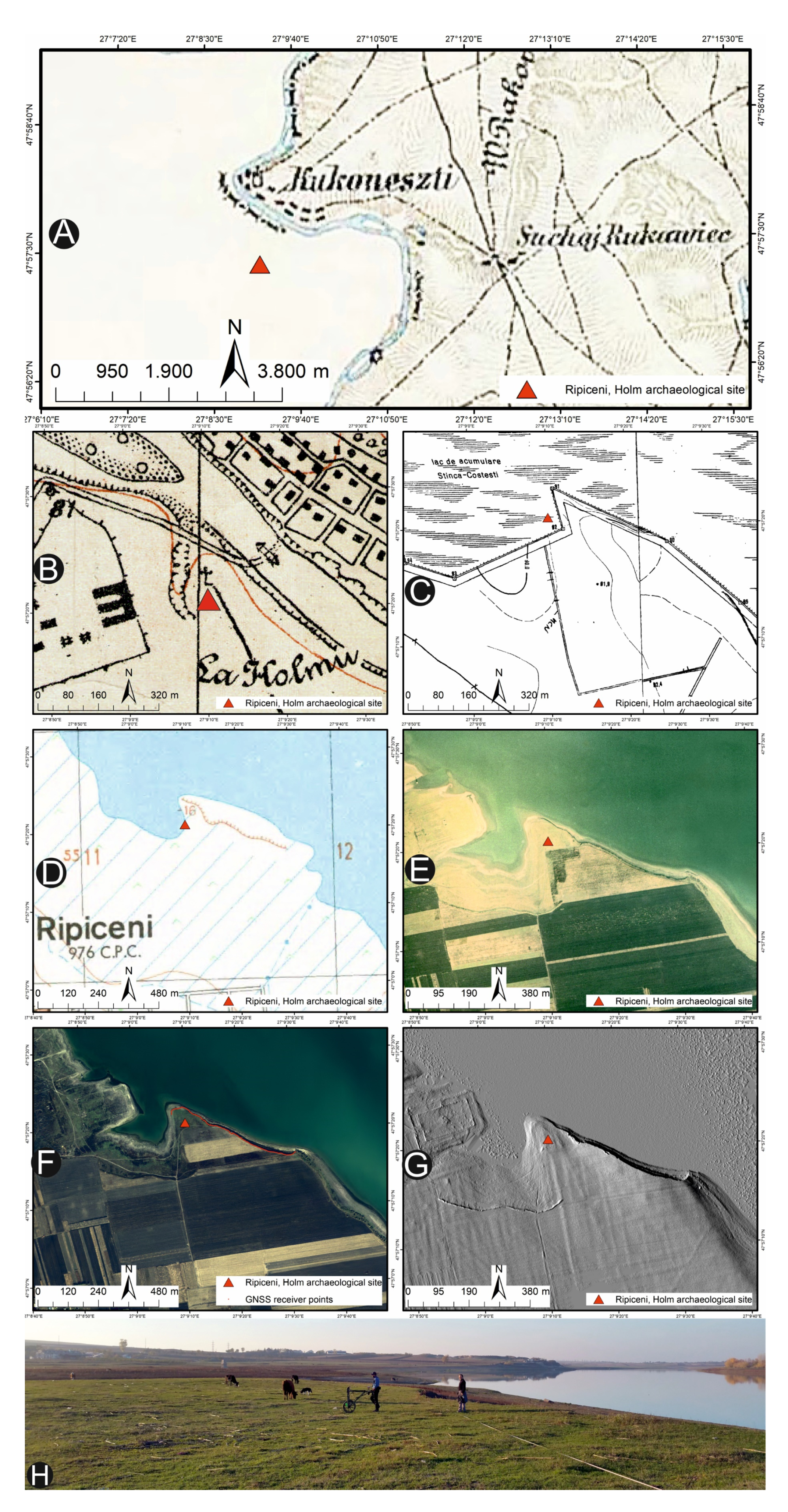
:
1. Introduction
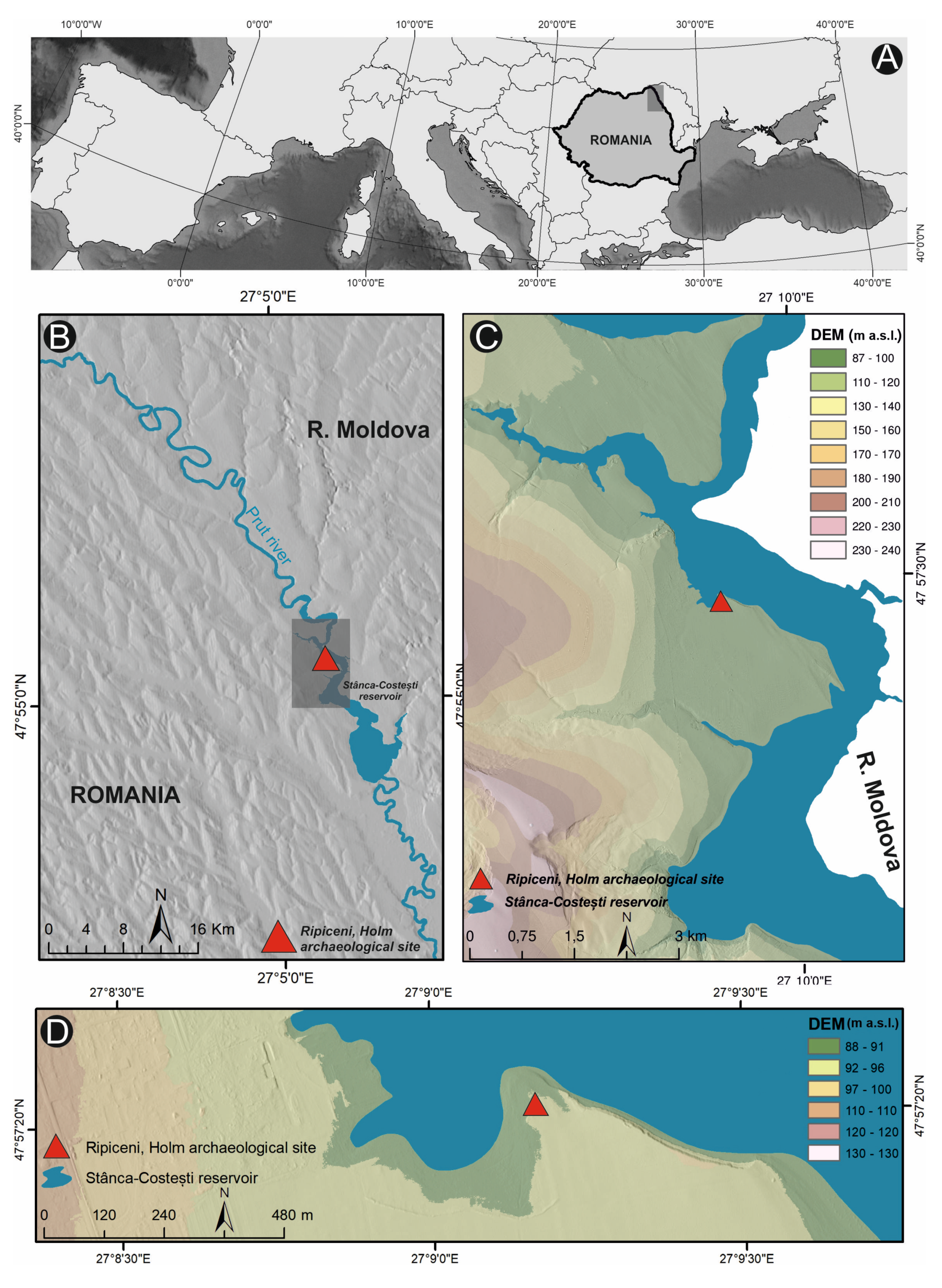
1.1. Regional Settings
1.2. Archaeological Background
2. Materials and Methods
3. Results
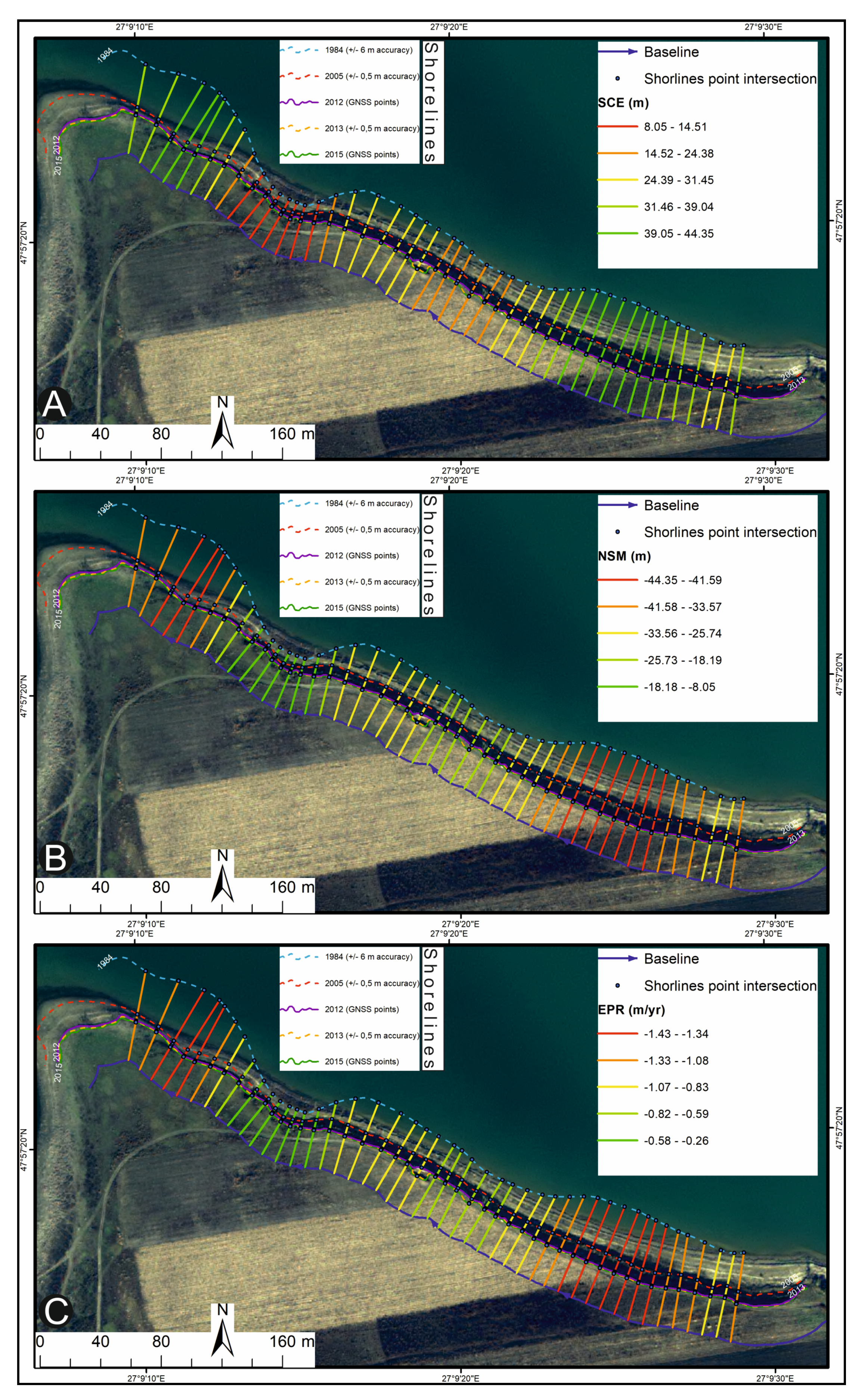
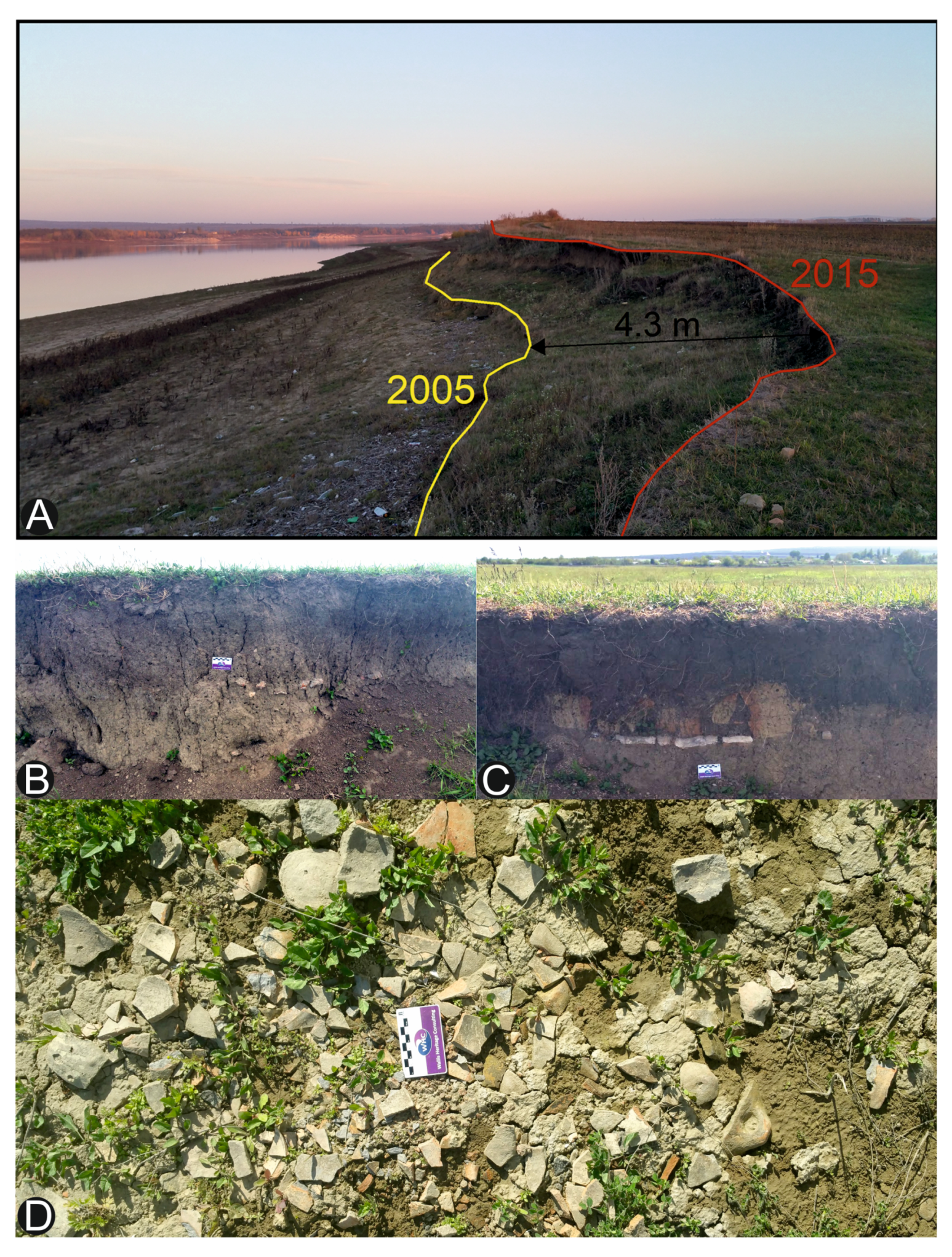
3.1. Cartographic and Geospatial Analysis
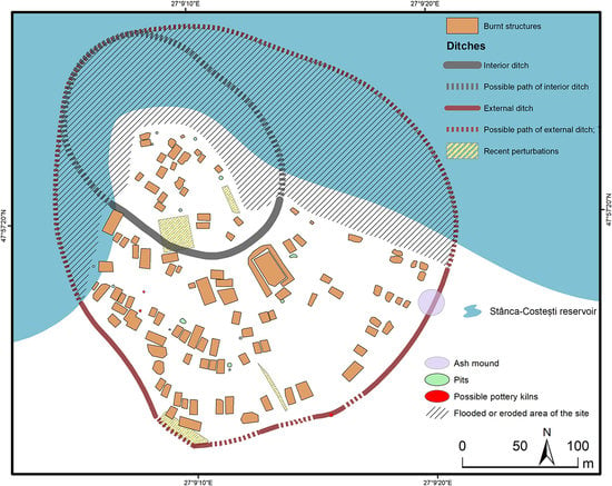
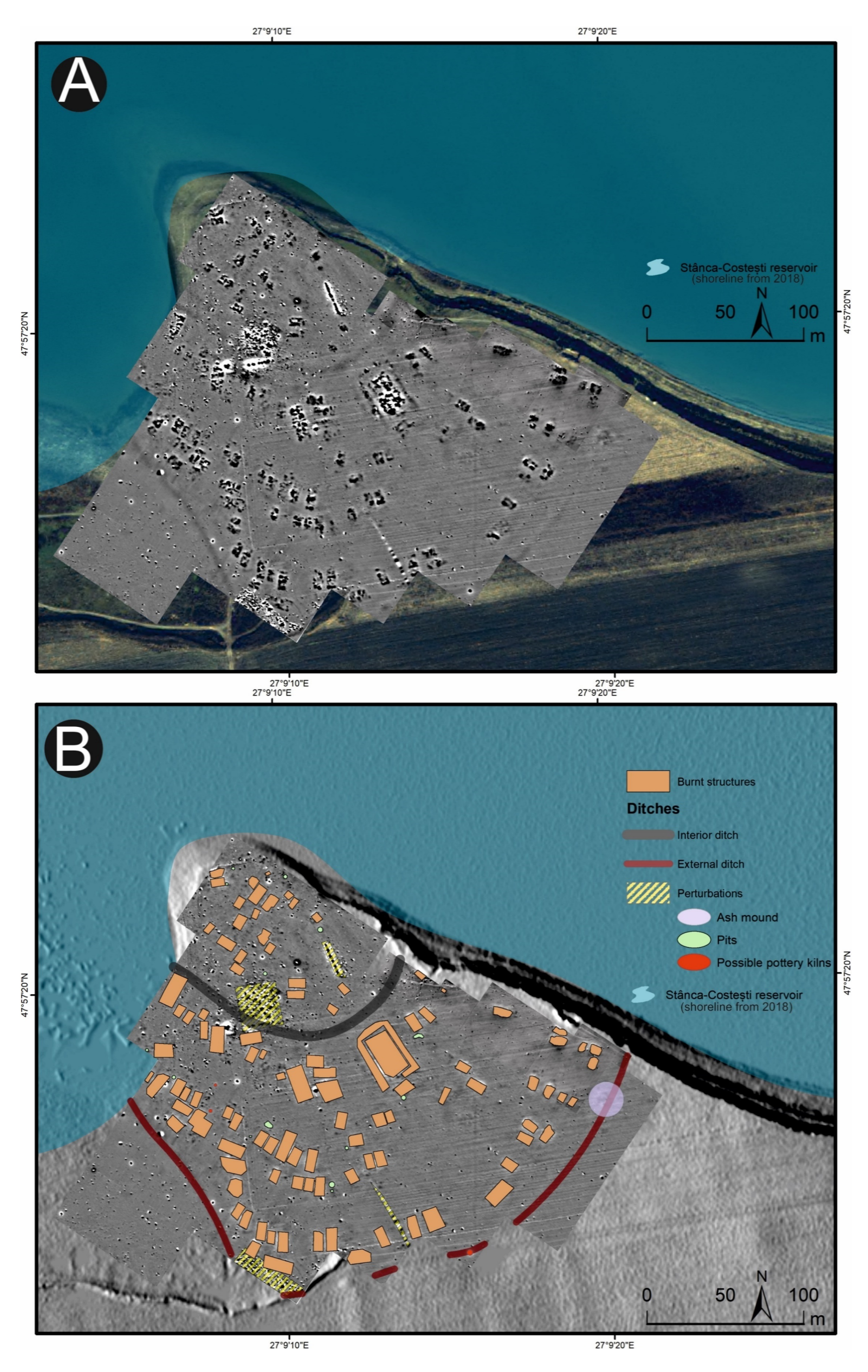
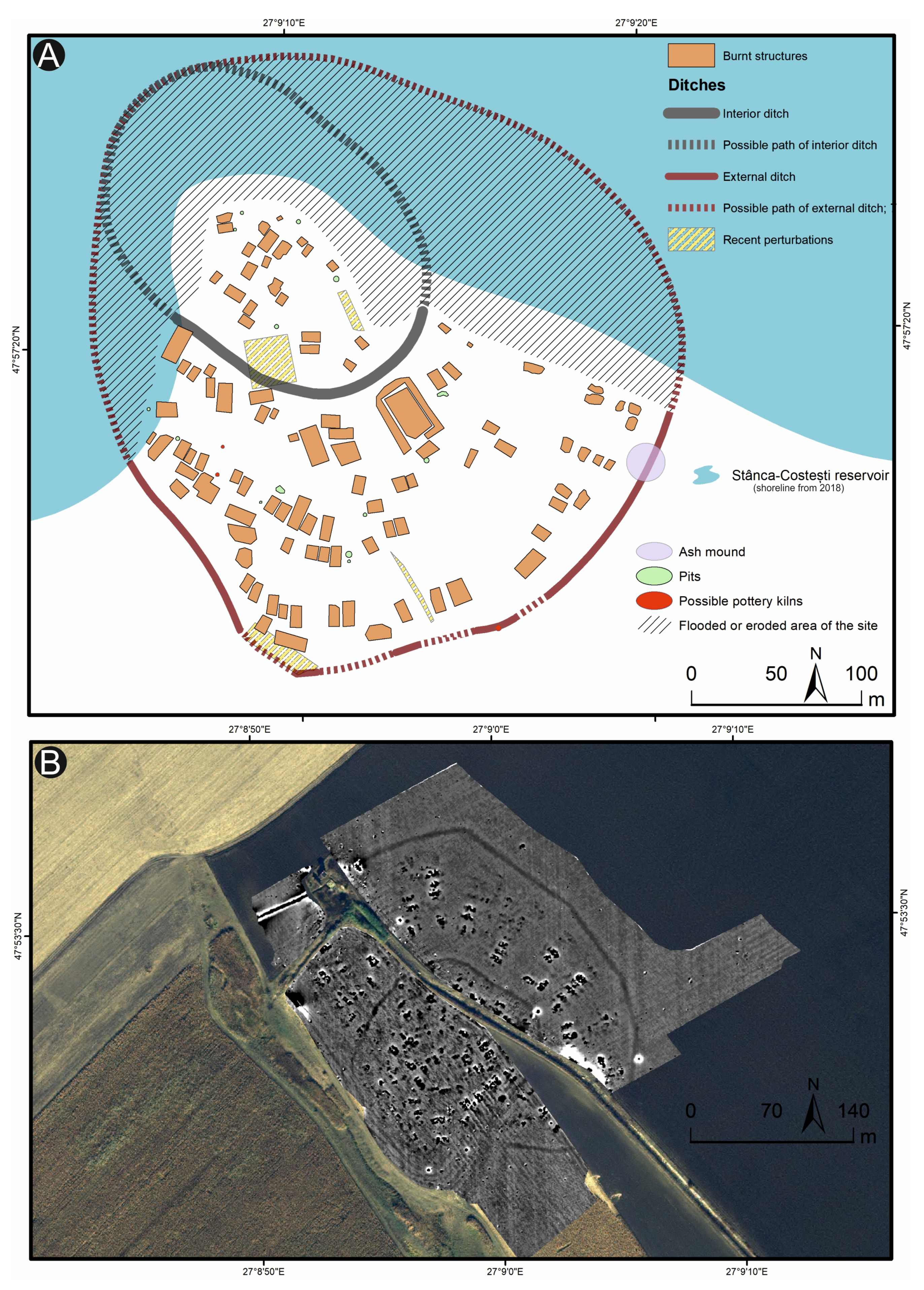
3.2. Magnetic Prospection Results
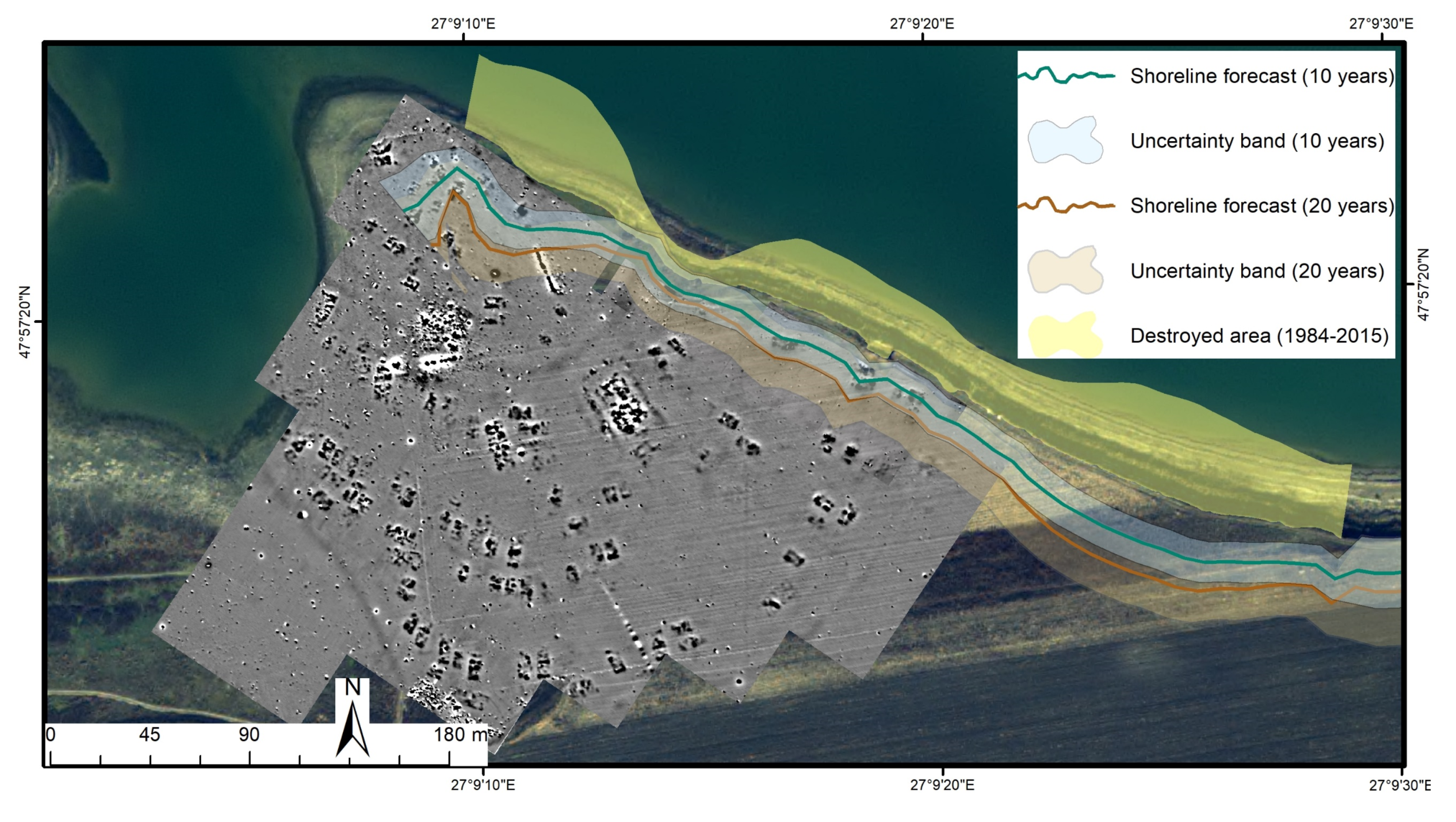
4. Discussion
5. Conclusions
Author Contributions
Funding
Acknowledgments
Conflicts of Interest
References
- Cozzolino, M.; Di Giovanni, E.; Mauriello, P.; Piro, S.; Zamuner, D. Management of Cultural Heritage: Contribution of Applied Geophysics. In Geophysical Methods for Cultural Heritage Management; Springer: Cham, The Netherlands, 2018; pp. 1–4. [Google Scholar] [CrossRef]
- Amit-Cohen, I.; Sofer, M. Cultural heritage and its economic potential in rural society: The case of the kibbutzim in Israel. Land Use Policy 2016, 57, 368–376. [Google Scholar] [CrossRef]
- Romanescu, G.; Cotiuga, V.; Asandulesei, A.; Stoleriu, C.C. Use of the 3-D scanner in mapping and monitoring the dynamic degradation of soils: Case study of the Cucuteni-Baiceni Gully on the Moldavian Plateau (Romania). Hydrol. Earth Syst. Sci. 2012, 16, 953–966. [Google Scholar] [CrossRef] [Green Version]
- Nicu, I.C. Is overgrazing really influencing soil erosion? Water 2018, 10, 1077. [Google Scholar] [CrossRef] [Green Version]
- Nicu, I.C.; Asandulesei, A. GIS-based evaluation of diagnostic areas in landslide susceptibility analysis of Bahluiet River Basin (Moldavian Plateau, NE Romania). Are Neolithic sites in danger? Geomorphology 2018, 314, 27–41. [Google Scholar] [CrossRef]
- Jiao, Y.; Zhao, D.; Ding, Y.; Liu, Y.; Xu, Q.; Qiu, Y.; Li, R. Performance evaluation for four GIS-based models purposed to predict and map landslide susceptibility: A case study at a World Heritage site in Southwest China. Catena 2019, 183, 104221. [Google Scholar] [CrossRef]
- Mineo, S.; Pappalardo, G. Sustainable Fruition of Cultural Heritage in Areas Affected by Rockfalls. Sustainability 2020, 12, 296. [Google Scholar] [CrossRef] [Green Version]
- Wang, J.-J. Flood risk maps to cultural heritage: Measures and process. J. Cult. Herit. 2015, 16, 210–220. [Google Scholar] [CrossRef]
- Kropáček, J.; Neckel, N.; Tyrna, B.; Holzer, N.; Hovden, A.; Gourmelen, N.; Hochschild, V. Repeated glacial lake outburst flood threatening the oldest Buddhist monastery in north-western Nepal. Nat. Hazards Earth Syst. Sci. 2015, 15, 2425–2437. [Google Scholar] [CrossRef] [Green Version]
- Marzeion, B.; Leverman, A. Loss of cultural world heritage and currently inhabited places to sea-level rise. Environ. Res. Lett. 2014, 9, 034001. [Google Scholar] [CrossRef]
- Howard, P.; Pinder, D. Cultural heritage and sustainability in the coastal zone: Experiences in south-west England. J. Cult. Herit. 2003, 4, 57–68. [Google Scholar] [CrossRef]
- Jazwa, C.S.; Johnson, K.N. Erosion of coastal archaeological sites on Santa Rosa Island, California. West. N. Am. Nat. 2018, 78, 302–327. [Google Scholar] [CrossRef]
- Nicu, I.C.; Stoleriu, C.C. Land use changes and dynamics over the last century around churches of Moldavia, Bukovina, Northern Romania—Challenges and future perspectives. Habitat Int. 2019, 88, 101979. [Google Scholar] [CrossRef]
- Fatorić, S.; Seekamp, E. Are cultural heritage and resources threatened by climate change? A systematic literature review. Clim. Chang. 2017, 142, 227–254. [Google Scholar] [CrossRef]
- Sesana, E.; Gagnon, A.S.; Bertolin, C.; Hughes, J. Adapting cultural heritage to climate change risks: Perspectives of cultural heritage experts in Europe. Geosciences 2018, 8, 305. [Google Scholar] [CrossRef] [Green Version]
- Hollesen, J.; Callanan, M.; Dawson, T.; Fenger-Nielsen, R.; Friesen, T.M.; Jensen, A.M.; Rockman, M. Climate change and the deteriorating archaeological and environmental archives of the Arctic. Antiquity 2018, 92, 573–586. [Google Scholar] [CrossRef]
- Nicu, I.C.; Usmanov, B.; Gainullin, I.; Galimova, M. Shoreline Dynamics and Evaluation of Cultural Heritage Sites on the Shores of Large Reservoirs: Kuibyshev Reservoir, Russian Federation. Water 2019, 11, 591. [Google Scholar] [CrossRef] [Green Version]
- Usmanov, B.; Nicu, I.C.; Gainullin, I.; Khomyakov, P. Monitoring and assessing the destruction of archaeological sites from Kuibyshev reservoir coastline, Tatarstan Republic, Russian Federation. A case study. J. Coast. Conserv. 2018, 22, 417–429. [Google Scholar] [CrossRef]
- Mihu-Pintilie, A.; Nicu, I.C. GIS-based Landform Classification of Eneolithic Archaeological Sites in the Plateau-plain Transition Zone (NE Romania): Habitation Practices vs. Flood Hazard Perception. Remote Sens. 2019, 11, 915. [Google Scholar] [CrossRef] [Green Version]
- Niculiță, M.; Mărgărint, M.C.; Santangelo, M. Archaeological evidence for Holocene landslide activity in the Eastern Carpathian lowland. Quatern. Int. 2016, 415, 175–189. [Google Scholar] [CrossRef]
- Niculiță, M.; Mărgărint, M.C. Landslides and fortified settlements as valuable cultural geomorphosites and geoheritage sites in the Moldavian Plateau, North-eastern Romania. Geoheritage 2017, 10, 613–634. [Google Scholar] [CrossRef]
- Asăndulesei, A. GIS (Geographic Information System), Fotogrametrie și Geofizică în Arheologie; Investigații non-invazive în așezări Cucuteni din România; Editura Universităţii “Alexandru Ioan Cuza”: Iaşi, Romania, 2015. [Google Scholar]
- Molina, R.; Anfuso, G.; Manno, G.; Gracia Prieto, F.J. The Mediterranean Coast of Andalusia (Spain): Medium-Term Evolution and Impacts of Coastal Structures. Sustainability 2019, 11, 3539. [Google Scholar] [CrossRef] [Green Version]
- Ruiz-Beltran, A.P.; Astorga-Moar, A.; Salles, P.; Appendini, C.M. Short-Term Shoreline Trend Detection Patterns Using SPOT-5 Image Fusion in the Northwest of Yucatan, Mexico. Estuar. Coast. 2019, 42, 1761–1773. [Google Scholar] [CrossRef]
- Sessford, E.G.; Bæverford, M.G.; Hormes, A. Terrestrial processes affecting unlithified coastal erosion disparities in central fjords of Svalbard. Polar Res. 2015, 34, 24122. [Google Scholar] [CrossRef] [Green Version]
- Agapiou, A. Remote sensing heritage in a petabyte-scale: Satellite data and heritage Earth Engine© applications. Int. J. Digit. Earth 2016, 10, 85–102. [Google Scholar] [CrossRef] [Green Version]
- Tapete, D.; Cigna, F. COSMO-SkyMed SAR for Detection and Monitoring of Archaeological and Cultural Heritage Sites. Remote Sens. 2019, 11, 1326. [Google Scholar] [CrossRef] [Green Version]
- Alexakis, D.; Sarris, A.; Astaras, T.; Albanakis, K. Integrated GIS, remote sensing and geomorphologic approaches for the reconstruction of the landscape habitation of Thessaly during the neolithic period. J. Archaeol. Sci. 2011, 38, 89–100. [Google Scholar]
- Cuca, B.; Agapiou, D. Impact of land-use change and soil erosion on cultural landscapes: The case of cultural paths and sites in Paphos district, Cyprus. Appl. Geomat. 2018, 10, 515–527. [Google Scholar] [CrossRef]
- Agapiou, A.; Lysandrou, V.; Themistocleous, K.; Hadjimitsis, D.G. Risk assessment of cultural heritage clusters using satellite imagery and GIS: The case study of Paphos District, Cyprus. Nat. Hazards 2016, 83, 5–20. [Google Scholar] [CrossRef]
- David, A.; Linford, N.; Linford, P. Geophysical Survey in Archaeological Field Evaluation; English Heritage Publishing: Swindon, UK, 2008. [Google Scholar]
- Gallo, D.; Ciminale, M.; Becker, H.; Masini, N. Remote sensing techniques for reconstructing a vast Neolithic settlement in Southern Italy. J. Archaeol. Sci. 2009, 36, 43–50. [Google Scholar]
- Sarris, A.; Papadopoulos, N.G.; Agapiou, A.; Salvi, M.C.; Hadjimitis, D.G.; Parkinson, W.A.; Yerkes, R.W.; Gyucha, A.; Duffy, P.R. Integration of geophysical surveys, ground hyperspectral measurements, aerial and satellite imagery for archaeological prospection of prehistoric sites: The case study of Vésztő-Mágor Tell, Hungary. J. Archaeol. Sci. 2013, 40, 1454–1470. [Google Scholar]
- Reynolds, J.M. An Introduction to Applied and Environmental Geophysics; John Wiley & Sons: Hoboken, NJ, USA, 1997. [Google Scholar]
- Fassbinder, J.W.E. Seeing beneath the farmland, steppe and desert soil: Magnetic prospecting and soil magnetism. J. Archaeol. Sci. 2015, 56, 85–95. [Google Scholar]
- Doneus, M. Openness as visualization technique for interpretative mapping of airborne LiDAR derived digital terrain models. Remote Sens. 2013, 5, 6427–6442. [Google Scholar]
- Kokalj, Ž.; Zakšek, K.; Oštir, K. Visualization of LiDAR derived relief models. In Interpreting Archaeological Topography: Airborne Laser Scanning, 3D Data and Ground Observation; Opitz, R.S., Cowley, D., Eds.; Oxbow Books: Oxford, UK, 2013; Volume 5, pp. 100–114. [Google Scholar]
- Agapiou, A.; Lysandrou, V.; Sarris, A.; Papadopoulos, N.; Hadjimitsis, D.G. Fusion of Satellite Multispectral Images Based on Ground-Penetrating Radar (GPR) Data for the Investigation of Buried Concealed Archaeological Remains. Geosciences 2017, 7, 40. [Google Scholar] [CrossRef] [Green Version]
- Tapete, D.; Cigna, F. InSAR data for geohazard assessment in UNESCO World Heritage sites: State-of-the-art and perspectives in the Copernicus era. Int. J. Appl. Earth Obs. Geoinf. 2017, 63, 24–32. [Google Scholar] [CrossRef]
- Asăndulesei, A. Inside a Cucuteni Settlement: Remote Sensing Techniques for Documenting an Unexplored Eneolithic Site from Northeastern Romania. Remote Sens. 2017, 9, 41. [Google Scholar] [CrossRef] [Green Version]
- Mihu-Pintilie, A.; Asandulesei, A.; Stoleriu, C.C.; Romanescu, G. GIS methods for assessment of hydrogeomorphic risk and anthropogenic impact which affect the archaeological sites. Case study: Dealul Mare archaeological site, Moldavian Plateau (Romania). Acta Geobalcanica 2016, 2, 35–43. [Google Scholar] [CrossRef]
- Romanescu, G.; Cimpianu, C.I.; Mihu-Pintilie, A.; Stoleriu, C.C. Historic flood events in NE Romania (post-1990). J. Maps 2017, 13, 787–798. [Google Scholar] [CrossRef]
- Nicu, I.C. Frequency ratio and GIS-based evaluation of landslide susceptibility applied to cultural heritage assessment. J. Cult. Herit. 2017, 28, 172–176. [Google Scholar] [CrossRef]
- Asăndulesei, A.; Nicu, I.C.; Balaur, R.; Caliniuc, Ș.; Asăndulesei, M.; Cotiugă, V. Integrated prospection methods for documenting threatened prehistoric archaeological sites from north-eastern Romania. Archaeol. Polona 2015, 53, 425–430. [Google Scholar]
- Boghian, D.; Melniciuc, A.; Vornicu, M.-D.; Vornicu, A. Ripiceni, com. Ripiceni, jud. Botoşani. Punct: Holm (La Telescu). Cod sit: 38740.03. Cronica Cercetãrilor Arheologice. Campania 2011 2012, 46, 149–153. [Google Scholar]
- Romanescu, G.; Stoleriu, C.C. Exceptional floods in the Prut basin, Romania, in the context of heavy rains in the summer of 2010. Nat. Hazards Earth Syst. Sci. 2017, 17, 381–396. [Google Scholar] [CrossRef] [Green Version]
- Stoleriu, C.C.; Romanescu, G.; Mihu-Pintilie, A. Using single-beam echo-sounder for assessing the silting rate from the largest cross-border reservoir of the Eastern Europe: Stanca-Costesti Lake, Romania and Republic of Moldova. Carpath. J. Earth Environ. 2019, 14, 83–94. [Google Scholar] [CrossRef]
- Monah, D.; Monah, F. The last great Chalcolithic civilization of Old Europe. In Cucuteni: The Last Great Chalcolithic Civilization of Old Europe; Mantu, C.M., Dumitroaia, G.H., Tsaravopoulos, A., Eds.; Athena Publishing & Printing House: Bucharest, Romania, 1997; pp. 15–98. [Google Scholar]
- Gimbutas, M. The Gods and Goddesses of Old Europe: Myths and Cult Images 7000–3500 BC; University of California Press: Los Angeles, CA, USA, 1974. [Google Scholar]
- Lazarovici, C.M.; Lazarovici, G.; Țurcanu, S. Cucuteni: A Great Civilization of the Prehistoric World; Editura Palatul Culturii: Iași, Romania, 2009. [Google Scholar]
- Mantu, C.M. Cultura Cucuteni: Evoluţie, Cronologie, Relaţii Culturale; Editura Nona: Piatra Neamţ, România, 1998. [Google Scholar]
- Bem, C. Noi propuneri pentru o schiţă cronologică a eneoliticului românesc. Pontica 2001, 33, 25–121. [Google Scholar]
- Boghian, D.; Enea, S.C.; Pîrnău, R.G.; Melniciuc, A.; Asăndulesei, A.; Tencariu, F.A. Încercare de reconstituire a evoluției peisajului preistoric în Depresiunea Prutului Mijlociu, microzona sitului cucutenian de la Ripiceni—Holm, jud. Botoșani (partea II). In Arheovest IV2—In honorem Adrian Bejan—Interdisciplinaritate în Arheologie și Istorie; Micle, D., Ed.; JATEPress Kiadó: Szeged, Hungary, 2016; Volume IV, pp. 561–590. [Google Scholar]
- Zaharia, N.; Petrescu-Dîmbovița, M.; Zaharia, E. Așezări Din Moldova: De la Paleolitic Pînă în Secolul Al XVIII-Lea; Editura Academiei Republicii Socialiste România: București, România, 1970. [Google Scholar]
- Danu, M.; Boghian, D.; Melniciuc, A.; Enea, S.C.; Vornicu, A. Cercetări arheobotanice în situl cucutenian Ripiceni-Holm/Telescu (județul Botoșani, România). Cercet. Istor. 2016, 35, 39–48. [Google Scholar]
- Boghian, D.; Melniciuc, A.; Setnic, E.G.; Kovacs, A.; Ciupu, M.S.; Asăndulesei, A.; Tencariu, F.A.; Pascariu, A.; Guțu, V. Ripiceni, com. Ripiceni, jud. Botoşani. Punct: Holm (La Telescu). Cod sit: 38740.03. Cronica Cercetãrilor Arheologice. Campania 2018 2019, 53, 166–169. [Google Scholar]
- Himmelstoss, E.A.; Henderson, R.E.; Kratzmann, M.G.; Farris, A.S. Digital Shoreline Analysis System (DSAS) version 5.0 user guide. In U.S. Geological Survey Open-File Report 2018-1179; U.S. Geological Survey: Reston, VA, USA, 2018. [Google Scholar] [CrossRef] [Green Version]
- Oyedotun, T.D.T. Shoreline geometry: DSAS as a tool for Historical Trend Analysis. In Geomorphological Techniques; Online Edition; British Society for Geomorphology: London, UK, 2014; Chapter 3, Section 2.2. [Google Scholar]
- Kalman, R. A New Approach to Linear Filtering and Prediction Problems. ASME J. Basic Eng. 1960, 82, 35–45. [Google Scholar] [CrossRef] [Green Version]
- Furlanetto, P.; Bondesan, A. Geomorphological evolution of the plain between the Livenza and Piave Rivers in the sixteenth and seventeenth centuries inferred by historical maps analysis (Mainland of Venice, Northeastern Italy). J. Maps 2015, 11, 261–266. [Google Scholar] [CrossRef] [Green Version]
- San-Antonio-Gómez, C.; Velilla, C.; Manzano-Agugliaro, F. Urban and landscape changes through historical maps: The Real Sitio of Aranjuez (1775-2005), a case study. Comput. Environ. Urban 2014, 44, 47–58. [Google Scholar] [CrossRef]
- Nicu, I.C. Tracking natural and anthropic risks from historical maps as a tool for cultural heritage assessment: A case study. Environ. Earth Sci. 2017, 76, 330. [Google Scholar] [CrossRef]
- Agapiou, A.; Lysandrou, V.; Alexakis, D.D.; Themistocleous, K.; Cuca, B.; Argyriou, A.; Hadjimitsis, D.G. Cultural heritage management and monitoring using remote sensing data and GIS: The case study of Paphos area, Cyprus. Comput. Environ. Urban 2015, 54, 230–239. [Google Scholar] [CrossRef]
- Nicu, I.C. Cultural heritage assessment and vulnerability using Analytic Hierarchy Process and Geographic Information Systems (Valea Oii catchment, North-eastern Romania). An approach to historical maps. Int. J. Disaster Risk Reduct. 2016, 20, 103–111. [Google Scholar] [CrossRef]
- Nicu, I.C. Natural risk assessment and mitigation of cultural heritage sites in North-eastern Romania (Valea Oii river basin). Area 2019, 51, 142–154. [Google Scholar] [CrossRef]
- Becker, H. Duo- and quadro-sensor configuration for high speed/high resolution magnetic prospecting with caesium magnetometer. In Magnetic Prospecting in Archaeological Sites; Becker, H., Fassbinder, J.W.E., Eds.; International Council on Monuments and Sites (ICOMOS): Munich, Germany, 2001; pp. 20–25. [Google Scholar]
- Fassbinder, J.W.E. Magnetometry for archaeology. In Encyclopedia of Geoarchaeology; Encyclopedia of Earth Sciences Series; Gilbert, A., Ed.; Springer: Dordrecht, The Netherlands, 2016; pp. 499–514. [Google Scholar]
- Becker, H. Caesium-magnetometry for landscape-archaeology. In Seeing the Unseen: Geophysics and Landscape Archaeology; Campana, S., Piro, S., Eds.; CRC Press—Taylor & Francis Group: London, UK, 2009; pp. 129–165. [Google Scholar]
- Kvamme, K.L. Magnetometry: Nature’s gift to archaeology. In Remote Sensing in Archaeology: An Explicitly North American Perspective; Johnson, J.K., Ed.; University Alabama Press: Tuscaloosa, AL, USA, 2006; pp. 205–233. [Google Scholar]
- Schmidt, A.R.; Linford, P.; Linford, N.; David, A.; Gaffney, C.F.; Sarris, A.; Fassbinder, J. EAC Guidelines for the Use of Geophysics in Archaeology: Questions to Ask and Points to Consider; EAC Guidelines 2; Europae Archaeologia Consilium (EAC), Association Internationale sans But Lucratif (AISBL): Namur, Belgium, 2015. [Google Scholar]
- Vilhena, R.M.; Mascarenha, M.M.D.A.; Sales, M.M.; Romão, P.D.A.; Luz, M.P.D. Estimating the Wind-Generated Wave Erosivity Potential: The Case of the Itumbiara Dam Reservoir. Water 2019, 11, 342. [Google Scholar] [CrossRef] [Green Version]
- De Souza Dias, V.; da Luz, M.P.; Medero, G.M.; Nascimento, D.T.F. An Overview of Hydropower Reservoirs in Brazil: Current Situation, Future Perspectives and Impacts of Climate Change. Water 2018, 10, 592. [Google Scholar] [CrossRef] [Green Version]
- Gatto, L.W.; Doe, W.W., III. Bank conditions and erosion along selected reservoirs. Environ. Geol. Water Sci. 1987, 9, 143–154. [Google Scholar] [CrossRef]
- Olson, E.R.; Ventura, S.J. Geospatial methods to examine shoreline erosion in the Chippewa Flowage: A case study. Lake Reserv. Manag. 2012, 28, 170–175. [Google Scholar] [CrossRef]
- Mazda, Y.; Wolanski, E.; King, B.; Sase, A.; Ohtsuka, D.; Magi, M. Drag force due to vegetation in mangrove swamps. Mangroves Salt Marshes 1997, 1, 193–199. [Google Scholar]
- Sorochin, V. Modalități de organizare a așezărilor complexului cultural Cucuteni-Tripolie. Arheol. Mold. 1993, 16, 69–86. [Google Scholar]
- Chitic, O. Elements d’habitat de la periode Cucuteni A et Cucuteni A-B de l’espace Pruto-dniestreen. In Etablissements et Habitations Prehistoriques. Structure, Organisation, Symbole. Actes du Colloque de Iași 10–12 Decembre 2007; Chirica, V., Văleanu, M.C., Eds.; Editura Pim: Iași, România, 2008; pp. 263–314. [Google Scholar]
- Rassmann, K.; Mertl, P.; Voss, H.U.; Bicbaev, V.; Popa, A.L.; Musteață, S. Copper Age settlements in Moldova: Insights into a complex phenomenon from recent geomagnetic surveys. In Trypillia Mega-Sites and European Prehistory 4100–3400 BCE; Müller, J., Rassmann, K., Videiko, M., Eds.; Routledge: New York, NY, USA, 2016; pp. 55–69. [Google Scholar]
- Țerna, S. Geomagnetic surveys of the Neolithic and the Copper Age sites from the Republic of Moldova (1968–2016): Main results, current state and future perspectives. Raport 2016, 11, 189–225. [Google Scholar]
- Videiko, M. Looking for Trypillya Culture Proto–Cities. 2005. Available online: http://www.academia.edu/7417015/Looking_for_Trypillya_Culture_proto-cities_2005_ (accessed on 5 January 2017).
- Chapman, J.; Videiko, M.; Gaydarska, B.; Burdo, N.; Hale, D. Architectural differentiation on a Trypillia mega-site: Preliminary report on the excavation of a mega-structure at Nebelivka, Ukraine. J. Neolit. Archaeol. 2014, 16, 135–156. [Google Scholar]
- Rassmann, K.; Piotrovskiy, A.K.; Videiko, M.; Müller, J. The new challenge for site plans and geophysics: Revealing the settlement structure of giant settlements by means of geomagnetic survey. In Trypillia Mega-Sites and European Prehistory 4100–3400 BCE; Müller, J., Rassmann, K., Videiko, M., Eds.; Routledge: New York, NY, USA, 2016; pp. 29–54. [Google Scholar]
- Rassmann, K.; Ohlrau, R.; Hofmann, R.; Mischka, C.; Burdo, N.; Videjko, M.; Müller, J. High precision Tripolye settlement plans, demographic estimations and settlement organization. J. Neolit. Archaeol. 2014, 16, 96–134. [Google Scholar] [CrossRef]
- Hofmann, R.; Müller, J.; Shatilo, L.; Videiko, M.; Ohlrau, R.; Rud, V.; Burdo, N.; Dal Corso, M.; Dreibrodt, S.; Kirleis, W. Governing Tripolye: Integrative architecture in Tripolye settlements. PLoS ONE 2019, 14, e0222243. [Google Scholar] [CrossRef] [Green Version]
- Müller, J.; Hofmann, R.; Ohlrau, R.; Shatilo, M. The social constitution and political organisation of Tripolye mega-sites: Hierarchy and balance. In Surplus without the State—Political Forms in Prehistory: 10Th Archaeological Conference of Central Germany, Halle, Germany, 19–21 October 2017; Meller, H., Gronenborn, D., Risch, R., Eds.; Landesamt für Denkmalpflege und Archäologie Sachsen Anhalt—Landesmuseum für Vorgeschichte: Halle, Germany, 2018; pp. 247–262. [Google Scholar]
- Vornicu-Țerna, A.; Țerna, S. Ripiceni-Popoaia: A new Cucuteni B settlement in North-Eastern Romania. Mem. Antiq. 2016, 31–32, 97–112. [Google Scholar]


© 2020 by the authors. Licensee MDPI, Basel, Switzerland. This article is an open access article distributed under the terms and conditions of the Creative Commons Attribution (CC BY) license (http://creativecommons.org/licenses/by/4.0/).
Share and Cite
Asăndulesei, A.; Tencariu, F.A.; Nicu, I.C. Pars pro toto—Remote Sensing Data for the Reconstruction of a Rounded Chalcolithic Site from NE Romania: The Case of Ripiceni–Holm Settlement (Cucuteni Culture). Remote Sens. 2020, 12, 887. https://0-doi-org.brum.beds.ac.uk/10.3390/rs12050887
Asăndulesei A, Tencariu FA, Nicu IC. Pars pro toto—Remote Sensing Data for the Reconstruction of a Rounded Chalcolithic Site from NE Romania: The Case of Ripiceni–Holm Settlement (Cucuteni Culture). Remote Sensing. 2020; 12(5):887. https://0-doi-org.brum.beds.ac.uk/10.3390/rs12050887
Chicago/Turabian StyleAsăndulesei, Andrei, Felix Adrian Tencariu, and Ionut Cristi Nicu. 2020. "Pars pro toto—Remote Sensing Data for the Reconstruction of a Rounded Chalcolithic Site from NE Romania: The Case of Ripiceni–Holm Settlement (Cucuteni Culture)" Remote Sensing 12, no. 5: 887. https://0-doi-org.brum.beds.ac.uk/10.3390/rs12050887