
Aerosol Characterization during the Summer 2017 Huge Fire Event on Mount Vesuvius (Italy) by Remote Sensing and In Situ Observations

 , and
, and 
Abstract
:
1. Introduction
2. Materials and Methods
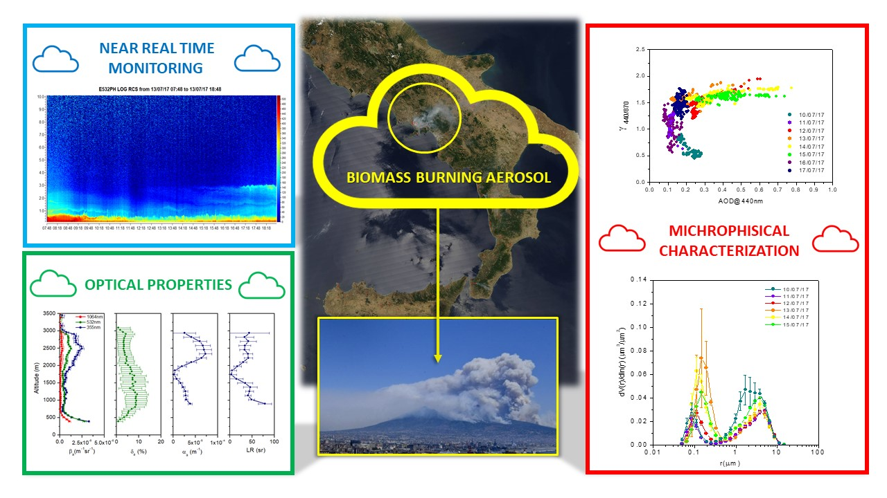
3. Results and Discussion
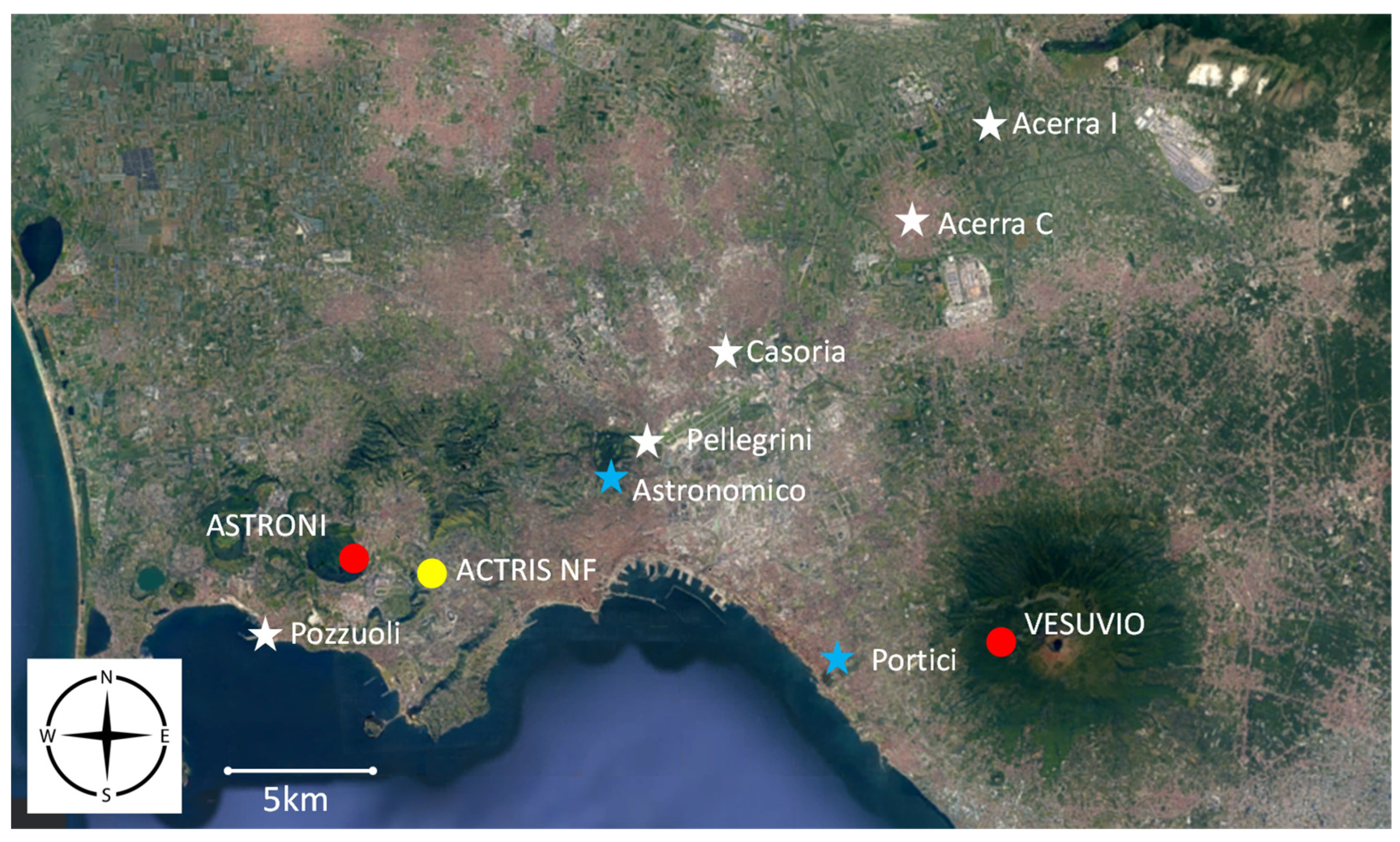
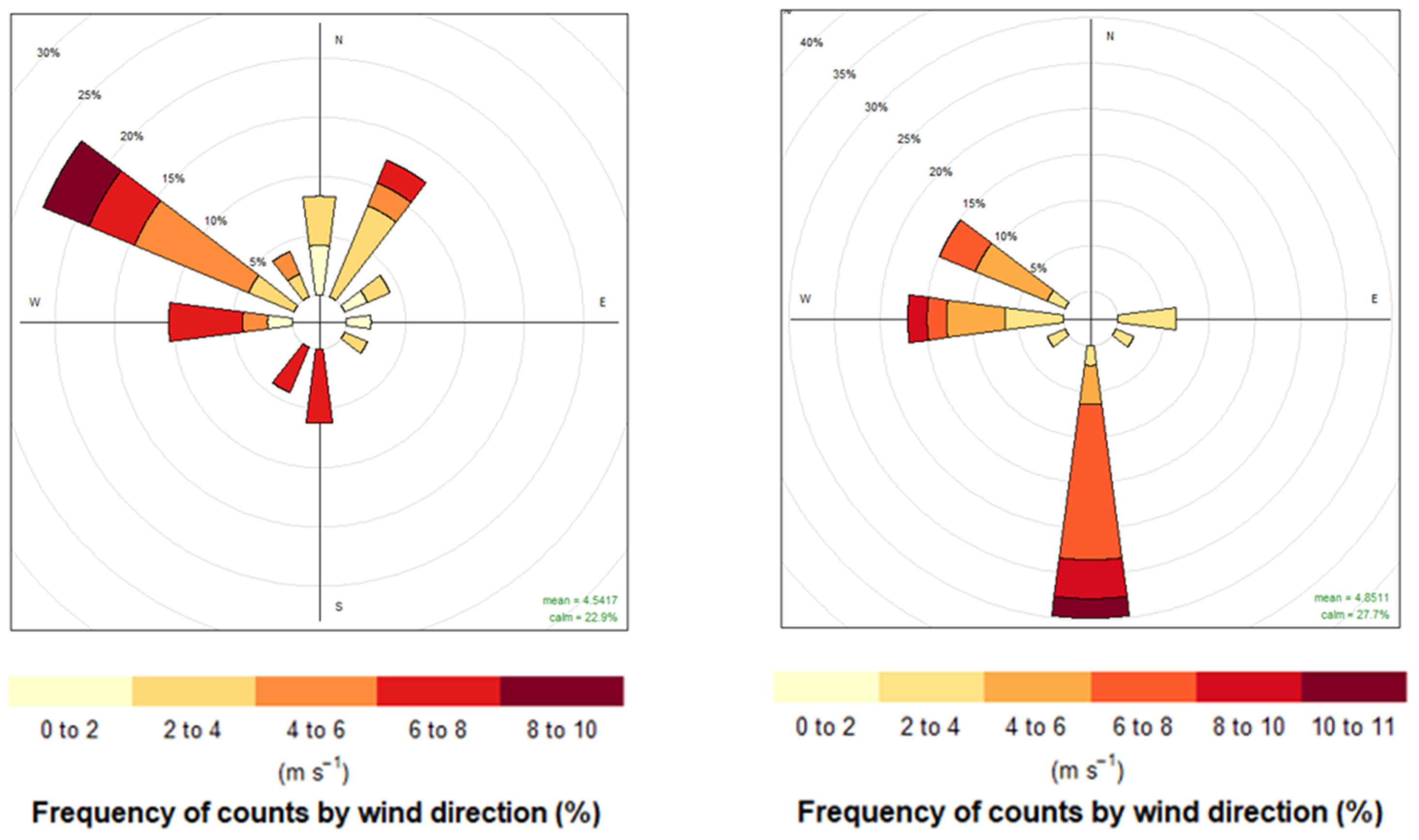
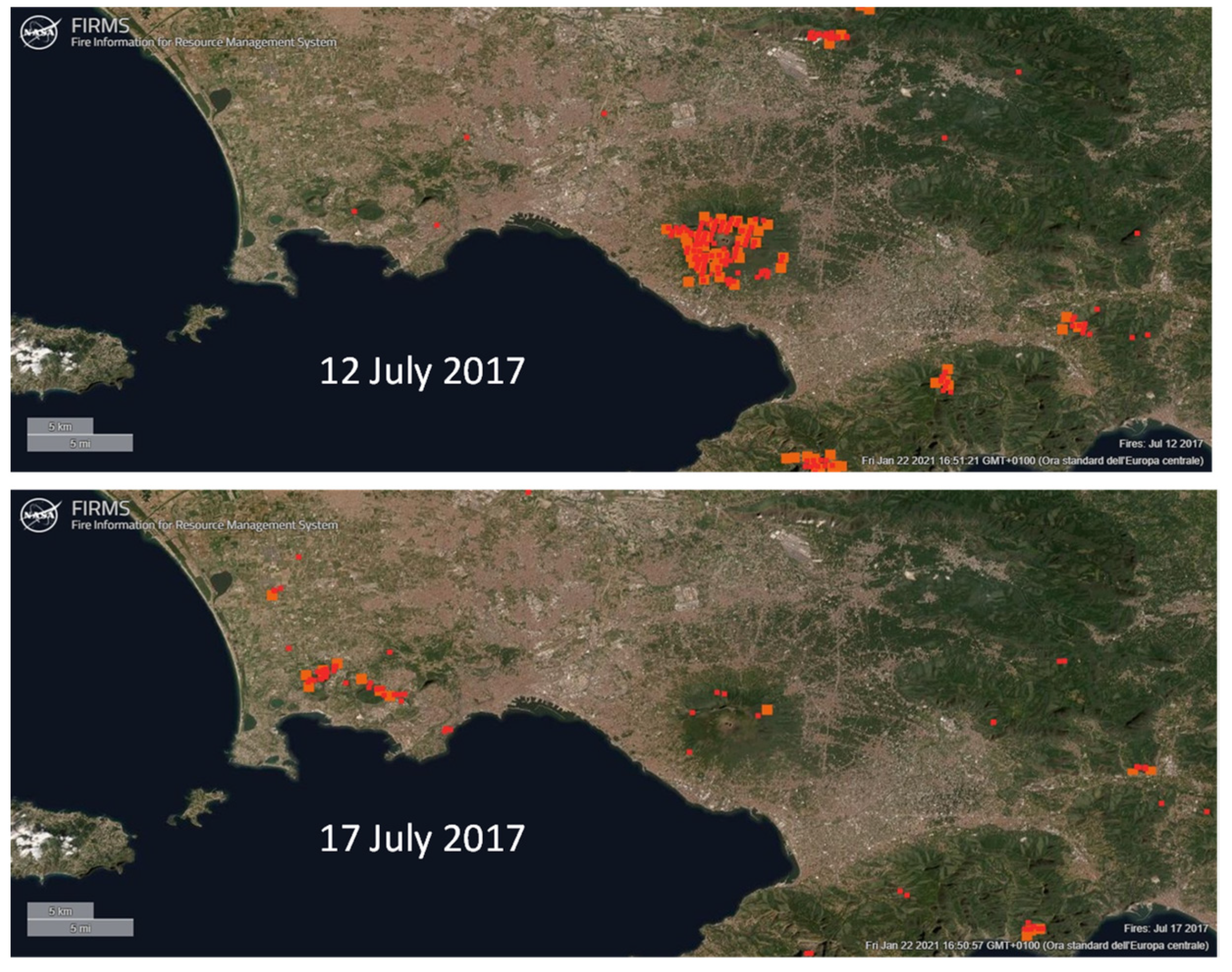
3.1. The Measurement Aera
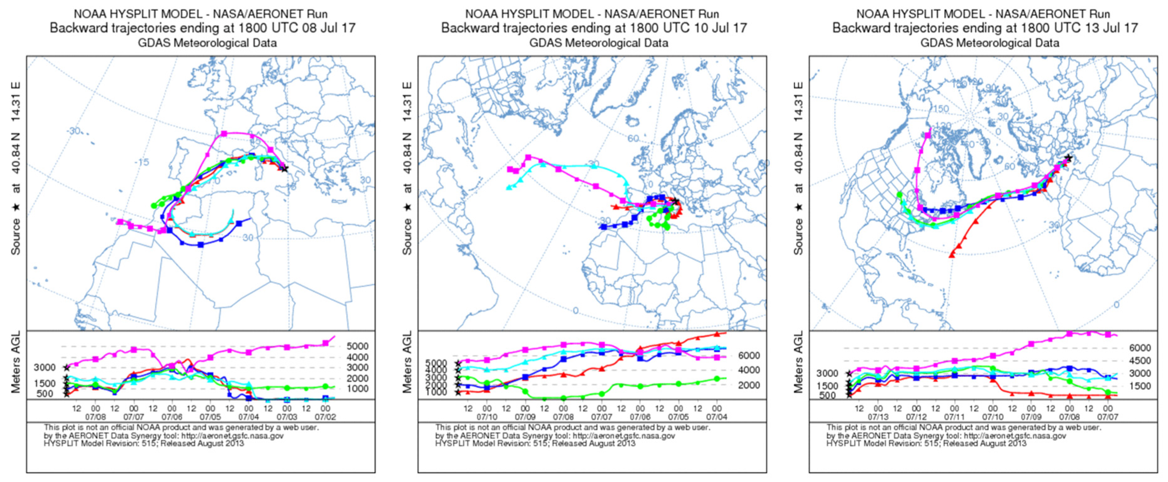
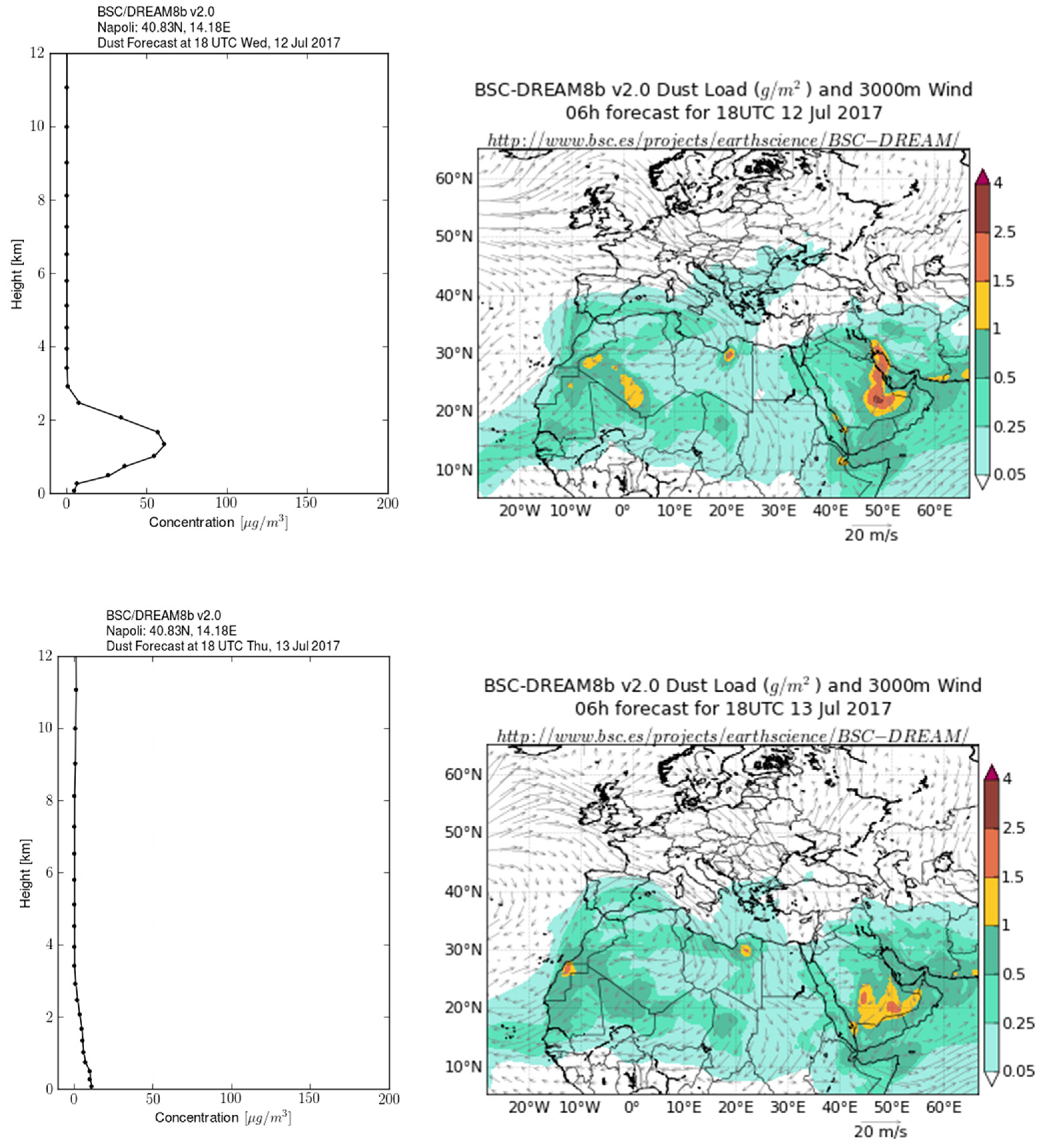
3.2. The Period 10–19 July 2017
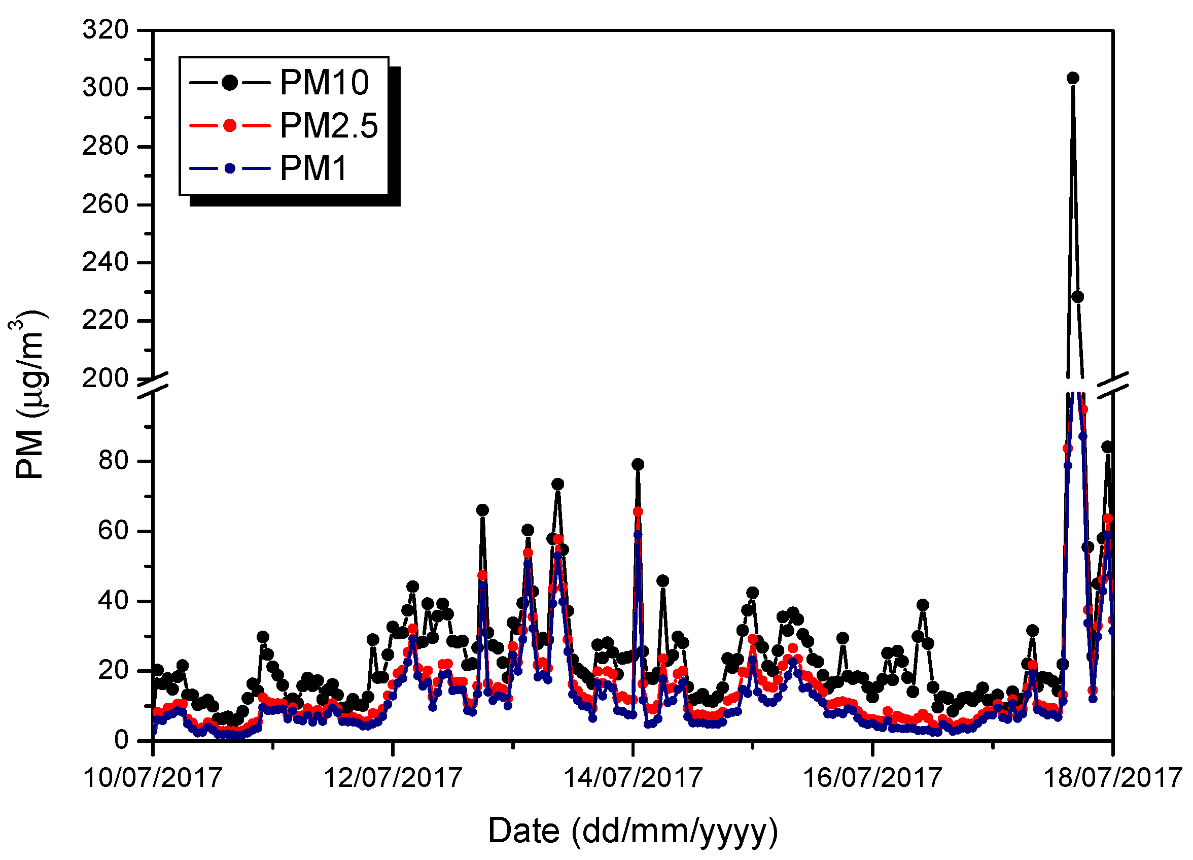
3.2.1. PM Mass Surface Concentrations
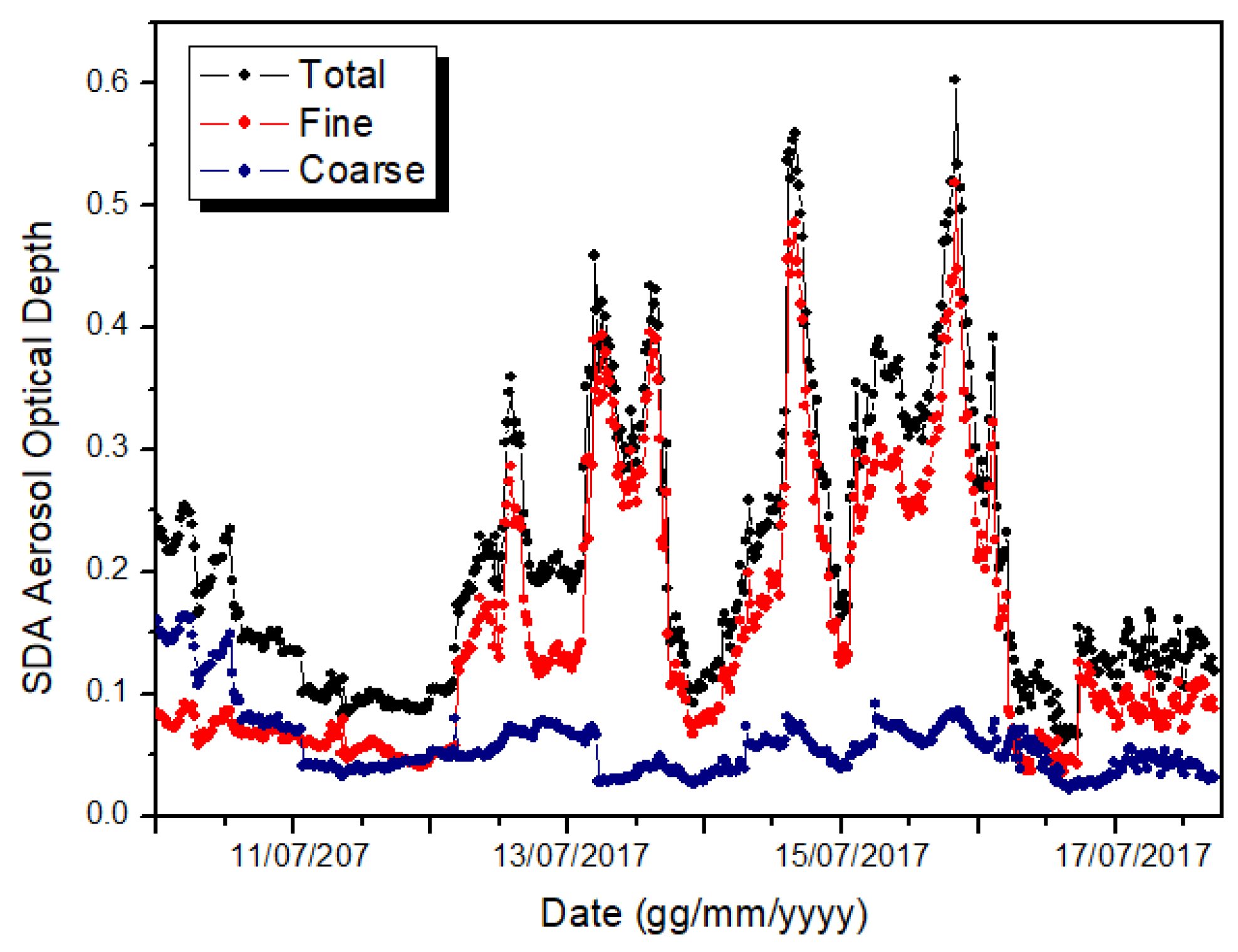
3.2.2. Columnar Aerosol Properties
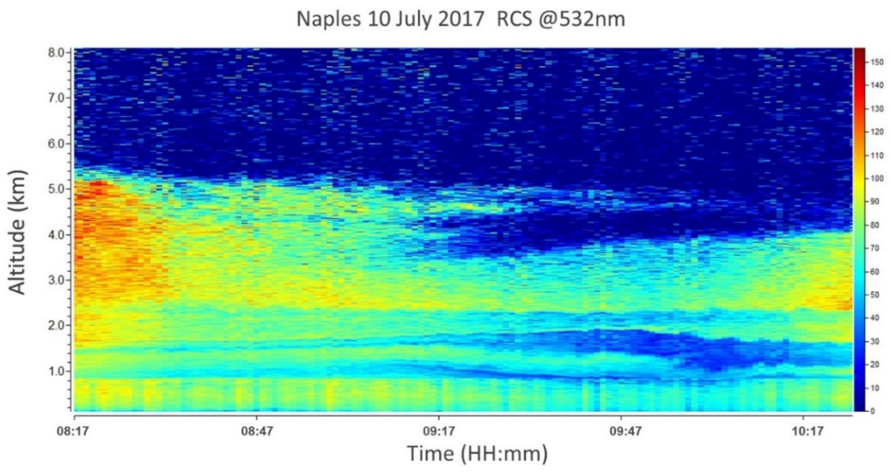
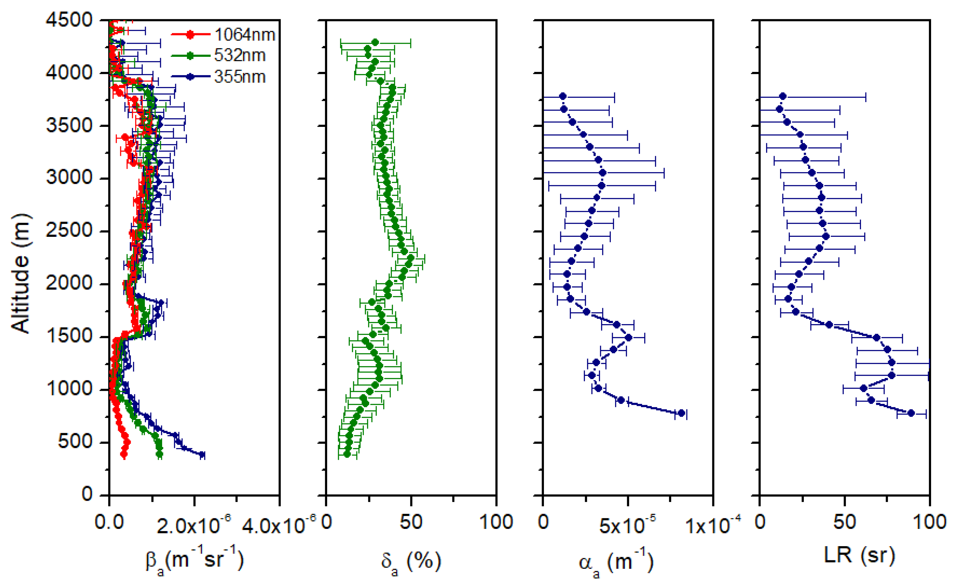
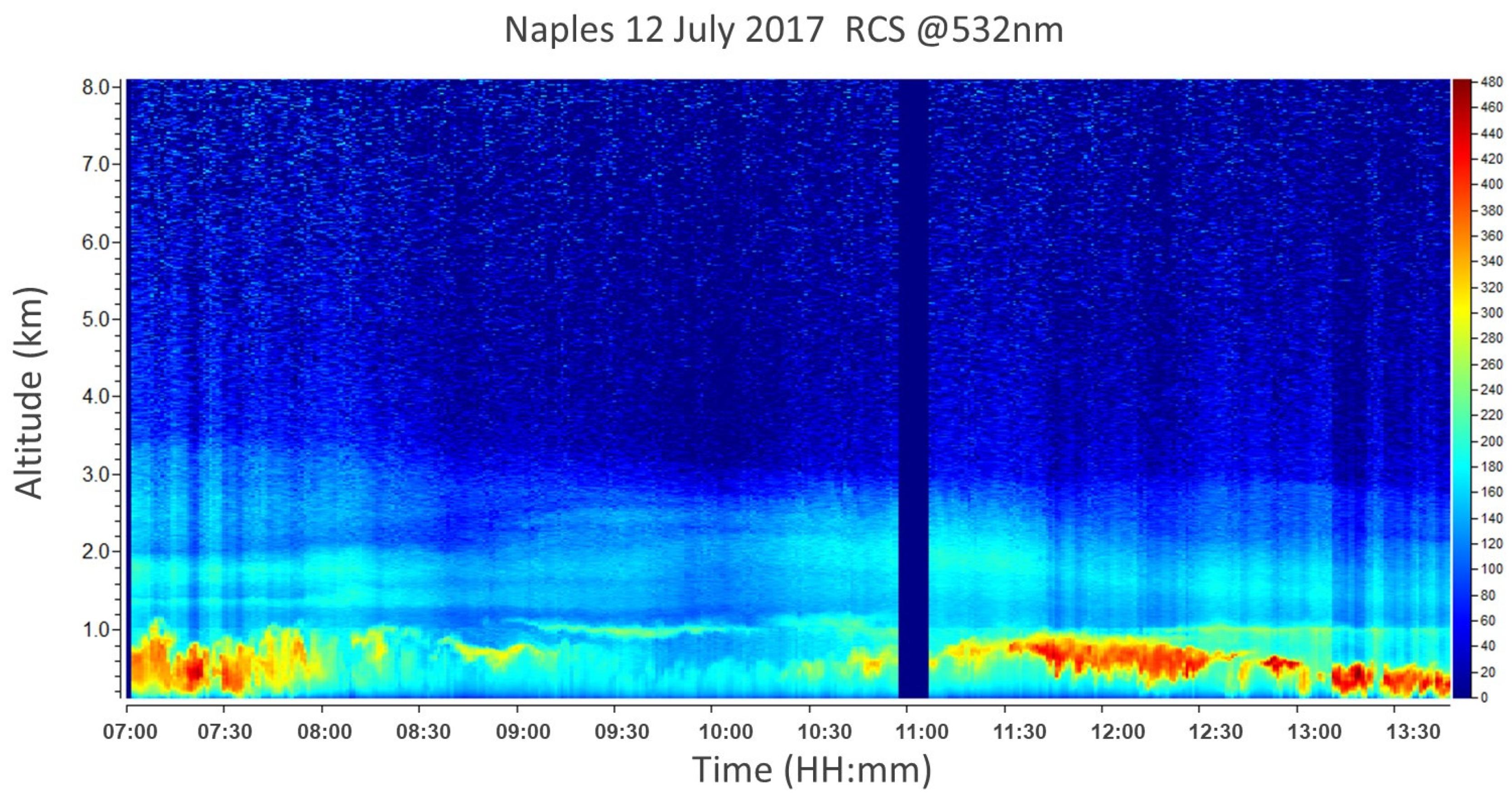
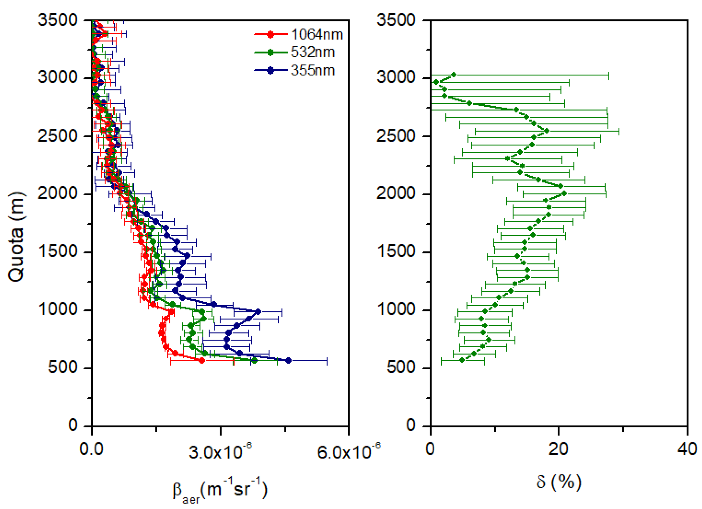
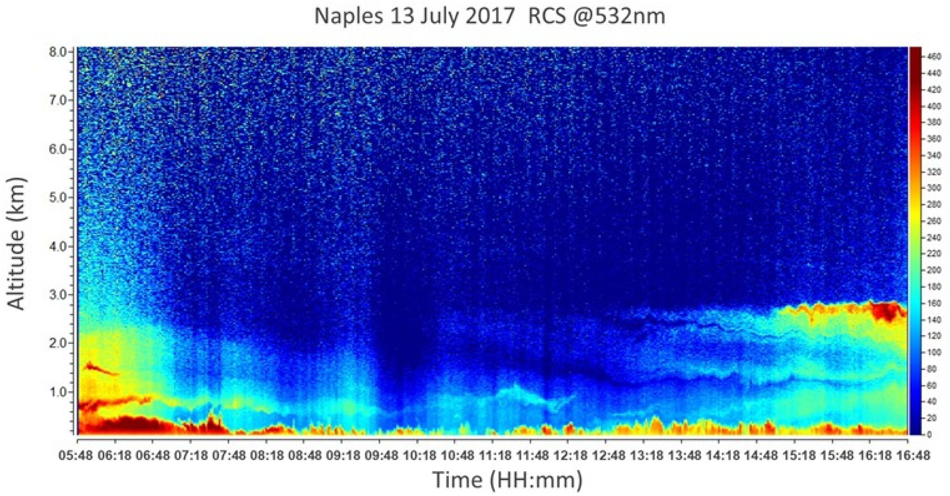
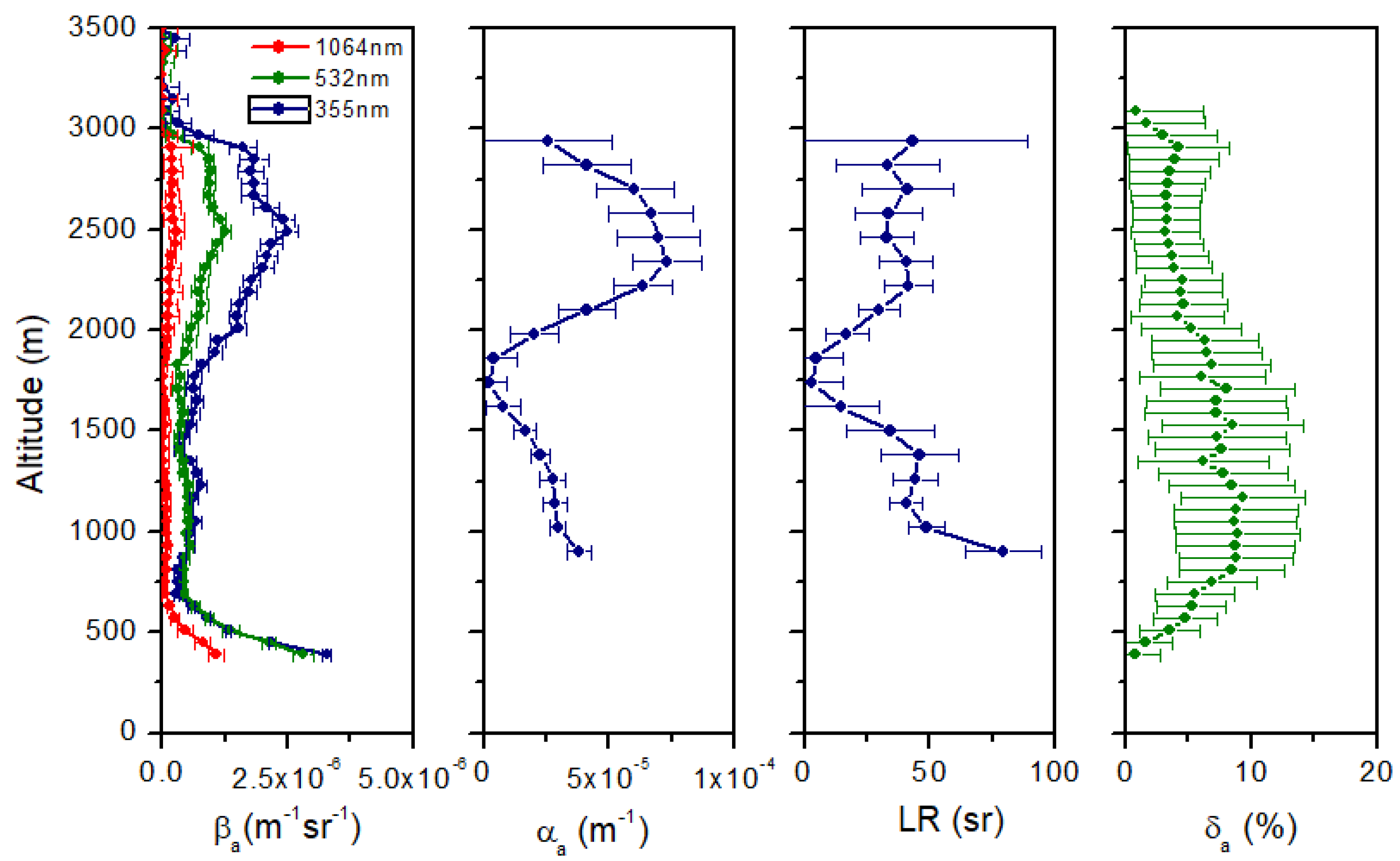
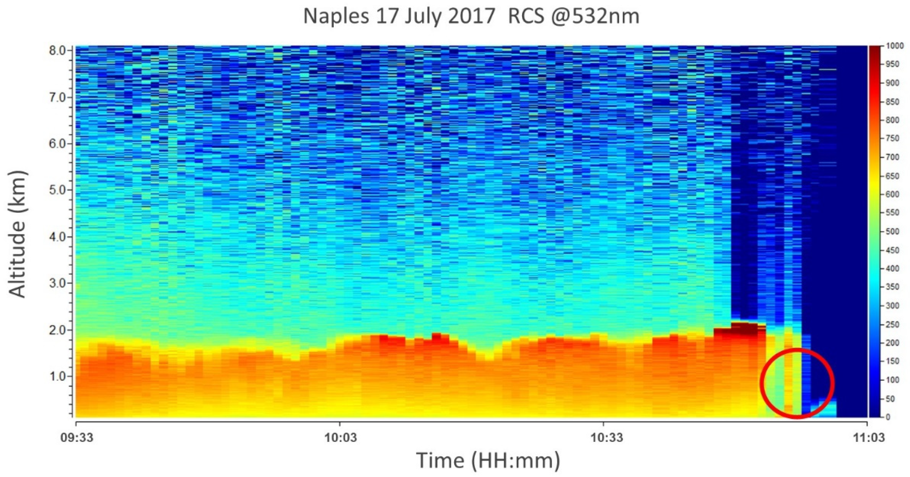
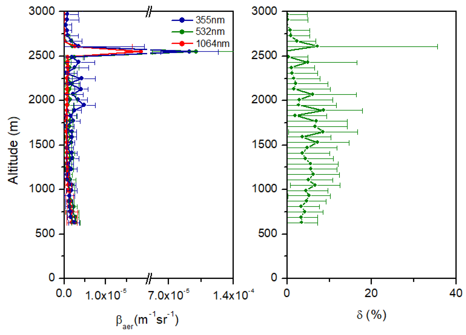
3.2.3. Lidar Remote Sensing Measurements
4. Summary
Author Contributions
Funding
Data Availability Statement
Acknowledgments
Conflicts of Interest
References
- Ghan, S.J.; Liu, X.; Easter, R.C., Jr.; Zaveri, R.A.; Rasch, P.J.; Yoon, J.H.; Eaton, B. Toward a minimal representation of aerosols in climate models: Comparative decomposition of aerosol direct, semidirect, and indirect radiative forcing. J. Clim. 2012, 25, 6461–6476. [Google Scholar] [CrossRef]
- Jacobson, M.Z. Effects of biomass burning on climate, accounting for heat and moisture fluxes, black and brown carbon, and cloud absorption effects. J. Geophys. Res. Atmos. 2014, 119, 8980–9002. [Google Scholar] [CrossRef]
- Shi, S.; Chenga, T.; Gua, X.; Guoa, H.; Wua, Y.; Wanga, Y. Biomass burning aerosol characteristics for different vegetation types in different aging periods. Environ. Int. 2019, 126, 504–511. [Google Scholar] [CrossRef] [PubMed]
- Samaras, S.; Nicolae, D.; Böckmann, C.; Vasilescu, C.; Binietoglou, I.; Labzovskii, L.; Toanca, F.; Papayannis, A. Using Raman-lidar-based regularized microphysical retrievals and Aerosol Mass Spectrometer measurements for the characterization of biomass burning aerosols. J. Comput. Phys. 2015, 299, 156–174. [Google Scholar] [CrossRef]
- Alonso-Blanco, E.; Calvo, A.I.; Pont, V.; Mallet, M.; Fraile, R.; Castro, A. Impact of Biomass Burning on Aerosol Size Distribution, Aerosol Optical Properties and Associated Radiative Forcing. Aerosol Air Qual. Res. 2014, 14, 708–724. [Google Scholar] [CrossRef] [Green Version]
- Sigsgaard, T.; Forsberg, B.; Annesi-Maesano, I.; Blomberg, A.; Bølling, A.; Boman, C.; Bønløkke, J.; Brauer, M.; Bruce, N.; Héroux, M.E.; et al. Health impacts of anthropogenic biomass burning in the developed world. Eur. Respir. J. 2015, 46, 1577–1588. [Google Scholar] [CrossRef] [Green Version]
- Veselovskii, I.; Whiteman, D.N.; Korenskiy, M.; Suvorina, A.; Kolgotin, A.; Lyapustin, A.; Wang, Y.; Chin, M.; Bian, H.; Kucsera, T.L.; et al. Characterization of forest fire smoke event near Washington, DC in summer 2013 with multi-wavelength lidar. Atmos. Chem. Phys. 2015, 15, 1647–1660. [Google Scholar] [CrossRef] [Green Version]
- Vaughan, G.; Draude, A.P.; Ricketts, H.M.A.; Schultz, D.M.; Adam, M.; Sugier, J.; Wareing, D.P. Transport of Canadian forest fire smoke over the UK as observed by lidar. Atmos. Chem. Phys. 2018, 18, 11375–11388. [Google Scholar] [CrossRef] [Green Version]
- Ansmann, A.; Baars, H.; Tesche, M.; Muller, D.; Althausen, D.; Engelmann, R.; Pauliquevis, T.; Artaxo, P. Dust and smoke transport from Africa to South America: Lidar profiling over Cape Verde and the Amazon rainforest. Geophys. Res. Lett. 2009, 36, L11802. [Google Scholar] [CrossRef]
- Baars, H.; Ansmann, A.; Ohneiser, K.; Haarig, M.; Engelmann, R.; Althausen, D.; Hanssen, I.; Gausa, M.; Pietruczuk, A.; Szkop, A.; et al. The unprecedented 2017–2018 stratospheric smoke event: Decay phase and aerosol properties observed with the EARLINET. Atmos. Chem. Phys. 2019, 19, 15183–15198. [Google Scholar] [CrossRef] [Green Version]
- Ortiz-Amezcua, P.; Guerrero-Rascado, J.L.; Granados-Muñoz, M.J.; Benavent-Oltra, J.A.; Böckmann, C.; Samaras, S.; Stachlewska, I.S.; Janicka, Ł.; Baars, H.; Bohlmann, S. Microphysical characterization of long-range transported biomass burning particles from North America at three EARLINET stations. Atmos. Chem. Phys. 2017, 17, 5931–5946. [Google Scholar] [CrossRef] [Green Version]
- Groß, S.; Freudenthaler, V.; Wirth, M.; Weinzierl, B. Towards an aerosol classification scheme for future EarthCARE lidar observations and implications for research needs. Atmos. Sci. Lett. 2015, 16, 77–82. [Google Scholar] [CrossRef] [Green Version]
- Haywood, J.M.; Pelon, J.; Formenti, P.; Bharmal, N.; Brooks, M.; Capes, G.; Chazette, P.; Chou, C.; Christopher, S.; Coe, H.; et al. Overview of the Dust and Biomass-burning Experiment and African Monsoon Multidisciplinary Analysis Special Observing Period-0. J. Geophys. Res. 2008, 113, D00C17. [Google Scholar] [CrossRef] [Green Version]
- Miller, D.; Sun, K.; Zondlo, M.A.; Kanter, D.; Dubovik, O.; Welton, E.J.; Winker, D.M.; Ginoux, P. Assessing boreal forest fire smoke aerosol impacts on U.S. air quality: A case study using multiple data sets. J. Geophys. Res. 2011, 116, D22209. [Google Scholar] [CrossRef] [Green Version]
- Zielinski, T.; Bolzacchini, E.; Cataldi, M.; Ferrero, L.; Graßl, S.; Hansen, G.; Mateos, D.; Mazzola, M.; Neuber, R.; Pakszys, P.; et al. Study of Chemical and Optical Properties of Biomass Burning Aerosols during Long-Range Transport Events toward the Arctic in Summer 2017. Atmosphere 2020, 11, 84. [Google Scholar] [CrossRef] [Green Version]
- Johnson, B.T.; Haywood, J.M.; Langridge, J.M.; Darbyshire, E.; Morgan, W.T.; Szpek, K.; Brooke, J.K.; Marenco, F.; Coe, H.; Artaxo, P.; et al. Evaluation of biomass burning aerosols in the HadGEM3 climate model with observations from the SAMBBA field campaign. Atmos. Chem. Phys. 2016, 16, 14657–14685. [Google Scholar] [CrossRef] [Green Version]
- Nicolae, D.; Nemuc, A.; Müller, D.; Talianu, C.; Vasilescu, J.; Belegante, L.; Kolgotin, A. Characterization of fresh and aged biomass burning events using multi-wavelength Raman lidar and mass spectrometry. J. Geophys. Res. 2013, 118, 2956–2965. [Google Scholar] [CrossRef]
- Janicka, L.; Stachlewska, I.S. Properties of biomass burning aerosol mixtures derived at fine temporal and spatial scales from Raman lidar measurements: Part I optical properties. Atmos. Chem. Phys. Discuss. 2019. [Google Scholar] [CrossRef] [Green Version]
- Saarnio, K.; Aurela, M.; Timonen, H.; Saarikoski, S.; Teinilä, K.; Mäkelä, T.; Sofiev, M.; Koskinen, J.; Aalto, P.P.; Kulmala, M.; et al. Chemical composition of fine particles in fresh smoke plumes from boreal wild-land fires in Europe. Sci. Total Environ. 2010, 408, 2527–2542. [Google Scholar] [CrossRef]
- Saulino, L.; Rita, A.; Migliozzi, A.; Maffei, C.; Allevato, E.; Garonna, A.P.; Saracino, A. Detecting Burn Severity across Mediterranean Forest Types by Coupling Medium-Spatial Resolution Satellite Imagery and Field Data. Remote Sens. 2020, 12, 741. [Google Scholar] [CrossRef] [Green Version]
- Pace, G.; Meloni, D.; Di Sarra, A. Forest fire aerosol over the Mediterranean basin during summer 2003. J. Geophys. Res. 2005, 110, D21202. [Google Scholar] [CrossRef] [Green Version]
- Majdi, M.; Kim, Y.; Turquety, S.; Sartelet, K. Impact of mixing state on aerosol optical properties during severe wildfires over the Euro-Mediterranean region. Atmos. Environ. 2020, 220, 117042. [Google Scholar] [CrossRef]
- Amiridis, V.; Zerefos, C.; Kazadzis, S.; Gerasopoulos, E.; Eleftheratos, K.; Vrekoussis, M.; Stohl, A.; Mamouri, R.E.; Kokkalis, P.; Papayannis, A.; et al. Impact of the 2009 Attica wild fires on the air quality in urban Athens. Atmos. Environ. 2012, 46, 536–544. [Google Scholar] [CrossRef]
- Pappalardo, G. ACTRIS Aerosol, Clouds and Trace Gases Research Infrastructure. EPJ Web Conf. 2018, 176, 09004. [Google Scholar] [CrossRef]
- Pappalardo, G.; Amodeo, A.; Apituley, A.; Comeron, A.; Freudenthaler, V.; Linné, H.; Ansmann, A.; Bösenberg, J.; D’Amico, G.; Mattis, I.; et al. EARLINET: Towards an advanced sustainable European aerosol lidar network. Atmos. Meas. Tech. 2014, 7, 2389–2409. [Google Scholar] [CrossRef] [Green Version]
- Freudenthaler, V.; Esselborn, M.; Wiegner, M.; Heese, B.; Tesche, M.; Ansmann, A.; Müller, D.; Althausen, D.; Wirth, M.; Fix, A.; et al. Depolarization ratio profiling at several wavelengths in pure Saharan dust during SAMUM 2006. Tellus B 2009, 61, 165–179. [Google Scholar] [CrossRef] [Green Version]
- Klett, J.D. Stable analytical inversion solution for processing lidar returns. Appl. Opt. 1981, 20, 211–220. [Google Scholar] [CrossRef] [Green Version]
- Fernald, F.G. Analysis of the atmospheric lidar observations; some comments. Appl. Opt. 1984, 23, 652–653. [Google Scholar] [CrossRef]
- Ansmann, A.; Riebesell, M.; Wandinger, U.; Weitkamp, C.; Voss, E.; Lahmann, W.; Michaelis, W. Combined raman elastic-backscatter LIDAR for vertical profiling of moisture, aerosol extinction, backscatter, and LIDAR ratio. Appl. Phys. B. 1992, 55, 18. [Google Scholar] [CrossRef]
- Liua, L.; Mishchenko, M.I. Constraints on PSC particle microphysics derived from lidar observations. J. Quant. Spectrosc. Radiat. Transf. 2001, 70, 817–831. [Google Scholar] [CrossRef] [Green Version]
- Ansmann, A.; Riebesell, M.; Weitkamp, C. Measurement of atmospheric aerosol extinction profiles with a Raman lidar. Opt. Lett. 1990, 15, 746–748. [Google Scholar] [CrossRef]
- Biele, J.; Beyerle, G.; Baumgarten, G. Polarization lidar: Corrections of instrumental effects. Opt. Express 2000, 7, 427–435. [Google Scholar] [CrossRef]
- Mylonaki, M.; Giannakaki, E.; Papayannis, A.; Papanikolaou, C.A.; Komppula, M.; Nicolae, D.; Papagiannopoulos, N.; Amodeo, A.; Baars, H.; Soupiona, O. Aerosol type classification analysis using EARLINET multiwavelength and depolarization lidar observations. Atmos. Chem. Phys. 2021, 21, 2211–2227. [Google Scholar] [CrossRef]
- Groß, S.; Esselborn, M.; Weinzierl, B.; Wirth, M.; Fix, A.; Petzold, A. Aerosol classification by airborne high spectral resolution lidar observations. Atmos. Chem. Phys. 2013, 13, 2487–2505. [Google Scholar] [CrossRef] [Green Version]
- Holben, B.N.; Eck, T.F.; Slutsker, I.; Tanré, D.; Buis, J.P.; Setzer, A.; Vermote, E.; Reagan, J.A.; Kaufman, Y.J.; Nakajima, T.; et al. AERONET—A federated instrument network and data archive for aerosol characterization. Remote Sens. Environ. 1998, 66, 1–16. [Google Scholar] [CrossRef]
- Holben, B.N.; Tanré, D.; Smirnov, A.; Eck, T.F.; Slutsker, I.; Abuhassan, N.; Newcomb, W.W.; Schafer, J.; Chatenet, B.; Lavenue, F.; et al. An emerging ground-based aerosol climatology: Aerosol optical depth from AERONET. J. Geophys. Res. 2001, 106, 12067–12097. [Google Scholar] [CrossRef]
- Dubovik, O.; King, M.D. A flexible inversion algorithm for the retrievalof aerosol optical properties from sun and sky radiance measurements. J. Geophys. Res. 2000, 105, 20673–20696. [Google Scholar] [CrossRef] [Green Version]
- Giles, D.M.; Sinyuk, A.; Sorokin, M.G.; Schafer, J.S.; Smirnov, A.; Slutsker, I.; Eck, T.F.; Holben, B.N.; Lewis, J.R.; Campbell, J.R.; et al. Advancements in the Aerosol Robotic Network (AERONET) Version 3 database-automated near-real-time quality control algorithm with improved cloud screening for Sun photometer aerosol optical depth (AOD) measurements. Atmos. Meas. Tech. 2019, 12, 169–209. [Google Scholar] [CrossRef] [Green Version]
- Reid, J.S.; Eck, T.F.; Christopher, S.A.; Hobbs, P.V.; Holben, B.N. Use of the Ångström exponent to estimate the variability of optical and physical properties of aging smoke particles in Brazil. J. Geophys. Res. 1999, 104, 27473–27489. [Google Scholar] [CrossRef]
- Sicard, M.; Mallet, M.; García-Vizcaíno, D.; Comerón, A.; Rocadenbosch, F.; Dubuisson, P.; Muñoz-Porcar, C. Intense dust and extremely fresh biomass burning outbreak in Barcelona, Spain: Characterization of their optical properties and estimation of their direct radiative forcing. Environ. Res. Lett. 2012, 7, 034016. [Google Scholar] [CrossRef] [Green Version]
- O’Neill, N.T.; Eck, T.F.; Smirnov, A.; Holben, B.N.; Thulasiraman, S. Spectral discrimination of coarse and fine mode optical depth. J. Geophys. Res. 2003, 108, 4559. [Google Scholar] [CrossRef]
- D’Emilio, M.; Macchiato, M.; Ragosta, M.; Simoniello, T. A method for the integration of satellite vegetation activities observations and magnetic susceptibility measurements for monitoring heavy metals in soil et al. J. Hazard. Mater. 2012, 241–242, 118–126. [Google Scholar] [CrossRef] [PubMed]
- Valenzuela, A.; Olmo, F.J.; Lyamani, H.; Granados-Muñoz, M.J.; Antón, M.; Guerrero-Rascado, J.L.; Quirantes, A.; Toledano, C.; Perez-Ramírez, D.; Alados-Arboledas, L. Aerosol transport over the western Mediterranean basin: Evidence of the contribution of fine particles to desert dust plumes over Alborán Island. J. Geophys. Res. Atmos. 2014, 119, 14028–14044. [Google Scholar] [CrossRef] [Green Version]
- Burgos, M.A.; Mateos, D.; Cachorro, V.E.; Toledano, C.; de Frutos, A.M.; Calle, A.; Herguedas, A.; Marcos, J.L. An analysis of high fine aerosol loading episodes in north-central Spain in the summer 2013—Impact of Canadian biomass burning episode and local emissions. Atmos. Environ. 2018, 184, 191–202. [Google Scholar] [CrossRef]
- Reid, J.S.; Hobbs, P.V. Physical and optical properties of young smoke from individual biomass fires in Brazil. J. Geophys. Res. 1998, 103, 32013–32030. [Google Scholar] [CrossRef]
- Alados-Arboledas, L.; Muller, D.; Guerrero-Rascado, J.L.; Navas-Guzman, F.; Perez-Ramırez, D.; Olmo, F.J. Optical and microphysical properties of fresh biomass burning aerosol retrieved by Raman lidar, and star-and sun-photometry. Geophys. Res. Lett. 2011, 38, L01807. [Google Scholar] [CrossRef]


| July 2017 | 10 | 11 | 12 | 13 | 14 | 15 | 16 | 17 |
|---|---|---|---|---|---|---|---|---|
| PM10 | 13 ± 5 | 15 ± 5 | 32 ± 10 | 33 ± 15 | 24 ± 14 | 24 ± 8 | 17 ± 8 | 55 ± 74 |
| PM2.5 | 6 ± 3 | 8 ± 2 | 19 ± 8 | 24 ± 13 | 15 ± 12 | 15 ± 6 | 6 ± 1 | 37 ± 47 |
| PM1 | 4 ± 3 | 7 ± 2 | 16 ± 7 | 21 ± 13 | 11 ± 11 | 11 ± 5 | 4 ± 1 | 34 ± 44 |
| PM2.5/PM10 | 0.4 ± 0.1 | 0.6 ± 0.1 | 0.6 ± 0.1 | 0.7 ± 0.1 | 0.6 ± 0.1 | 0.6 ± 0.1 | 0.4 ± 0.1 | 0.7 ± 0.1 |
| July 2017 | 10th | 11th | 12th | 13th |
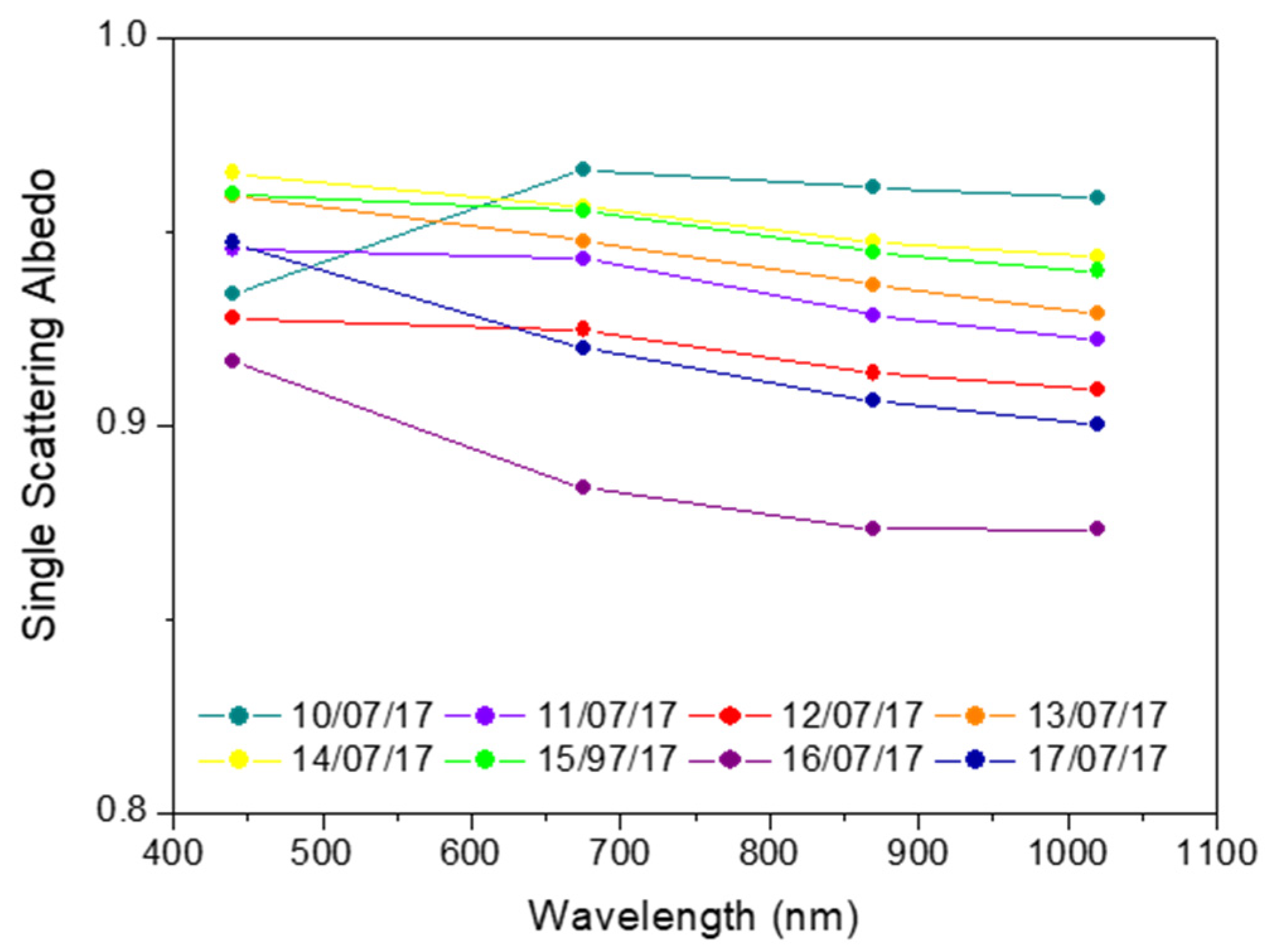
| AOD@440 nm | 0.21 ± 0.04 | 0.12 ± 0.01 | 0.29 ± 0.08 | 0.30 ± 0.14 |
| γ (440/870) | 0.66 ± 0.15 | 1.08 ± 0.15 | 1.47 ± 0.17 | 1.68 ± 0.14 |
| SSA@440 nm | 0.93 ± 0.03 | 0.94 ± 0.03 | 0.93 ± 0.03 | 0.96 ± 0.02 |
| July 2017 | 14th | 15th | 16th | 17th |
| AOD@440 nm | 0.38 ± 0.13 | 0.44 ± 0.10 | 0.11 ± 0.03 | 0.17 ± 0.02 |
| γ (440/870) | 1.63 ± 0.10 | 1.61 ± 0.05 | 1.05 ± 0.23 | 1.49 ± 0.13 |
| SSA@440 nm | 0.96 ± 0.01 | 0.96 ± 0.03 | 0.92 ± 0.05 | 0.95 ± 0.03 |
| July 2017 | Altitude | LR | δa |
|---|---|---|---|
| 10 (SD) | 2000–4000 m | 28 ± 9 sr | 37 ± 7% |
| 12 (Mixed) | 600–2800 m | 13 ± 4% | |
| 13 (Fire) | 1750–3000 m | 37 ± 5sr | 3.9 ± 0.6% |
| 17 (Fire) | 600–3000 m | 4.1 ± 1.6% |
Publisher’s Note: MDPI stays neutral with regard to jurisdictional claims in published maps and institutional affiliations. |
© 2021 by the authors. Licensee MDPI, Basel, Switzerland. This article is an open access article distributed under the terms and conditions of the Creative Commons Attribution (CC BY) license (https://creativecommons.org/licenses/by/4.0/).
Share and Cite
Boselli, A.; Sannino, A.; D’Emilio, M.; Wang, X.; Amoruso, S. Aerosol Characterization during the Summer 2017 Huge Fire Event on Mount Vesuvius (Italy) by Remote Sensing and In Situ Observations. Remote Sens. 2021, 13, 2001. https://0-doi-org.brum.beds.ac.uk/10.3390/rs13102001
Boselli A, Sannino A, D’Emilio M, Wang X, Amoruso S. Aerosol Characterization during the Summer 2017 Huge Fire Event on Mount Vesuvius (Italy) by Remote Sensing and In Situ Observations. Remote Sensing. 2021; 13(10):2001. https://0-doi-org.brum.beds.ac.uk/10.3390/rs13102001
Chicago/Turabian StyleBoselli, Antonella, Alessia Sannino, Mariagrazia D’Emilio, Xuan Wang, and Salvatore Amoruso. 2021. "Aerosol Characterization during the Summer 2017 Huge Fire Event on Mount Vesuvius (Italy) by Remote Sensing and In Situ Observations" Remote Sensing 13, no. 10: 2001. https://0-doi-org.brum.beds.ac.uk/10.3390/rs13102001