
Pre-Orientale Southwest Peak-Ring Basin: Gravity Structure, Geologic Characteristics, and Influence on Orientale Basin Ring Formation and Ejecta Emplacement


Abstract
:
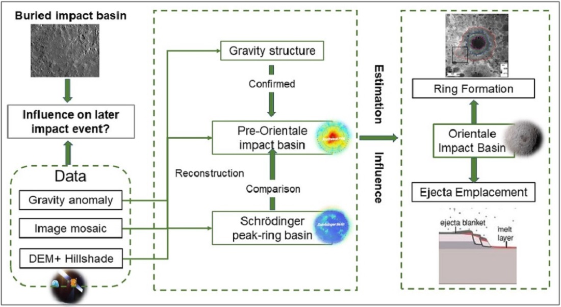
1. Introduction
2. Data and Methods
2.1. Data
2.2. Methods
3. Results
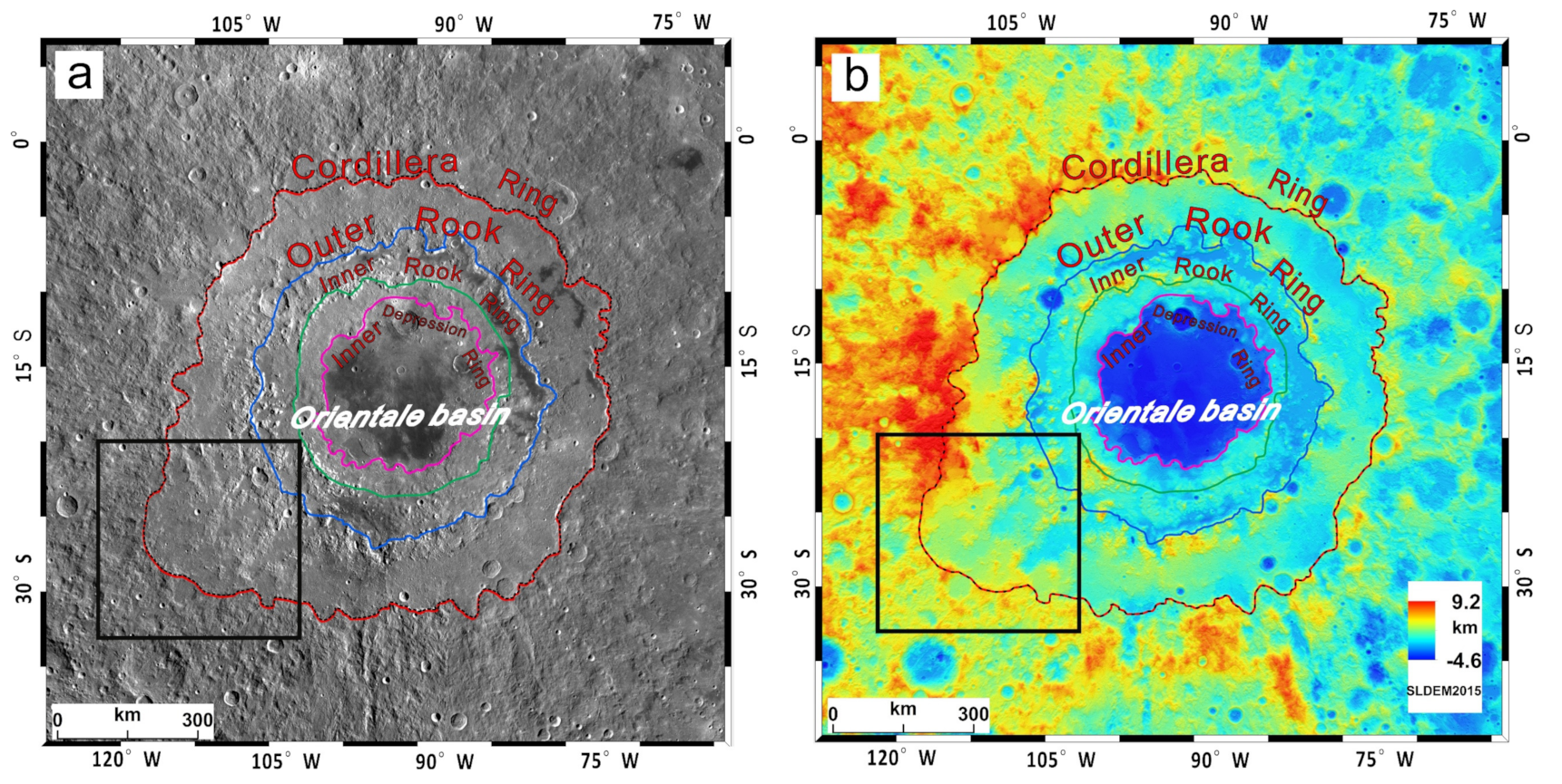
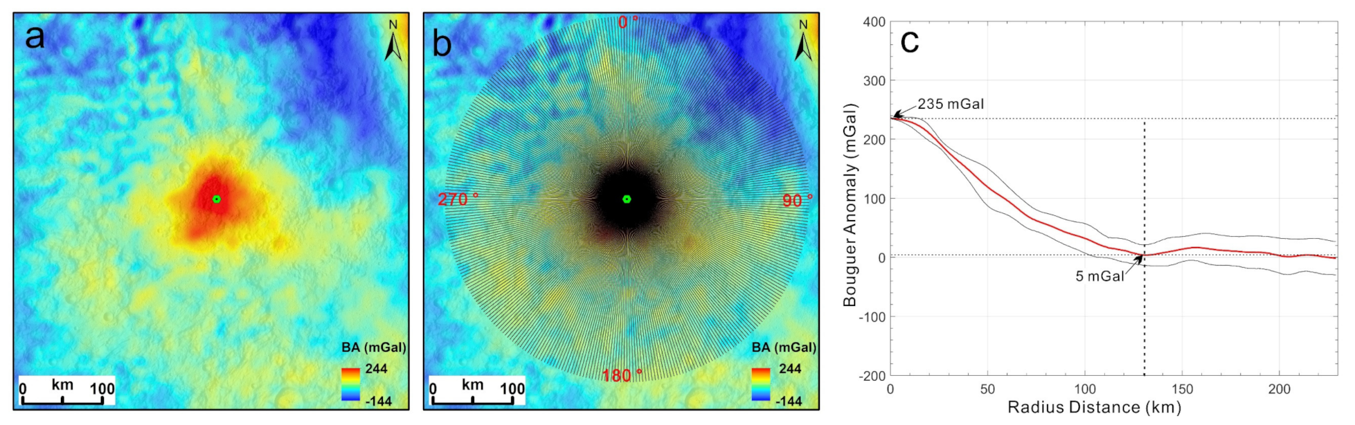
3.1. GRAIL Bouguer Gravity Anomaly Reconstruction
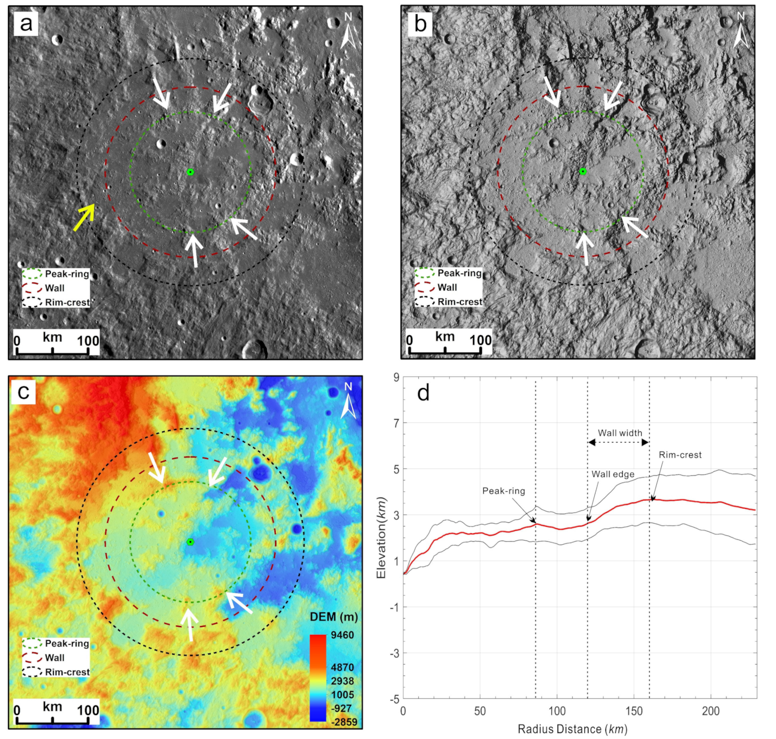
3.2. Topographic Reconstruction of the Original Basin
3.3. Morphologic Reconstruction: Comparison to Schrödinger Peak–Ring Basin
4. Discussion
5. Conclusions
Author Contributions
Funding
Data Availability Statement
Acknowledgments
Conflicts of Interest
References
- Hartmann, W.K.; Wood, C.A. Moon: Origin and evolution of multi-ring basins. Moon 1971, 3, 3–78. [Google Scholar] [CrossRef]
- Head, J.W. Orientale multi-ringed basin interior and implications for the petrogenesis of lunar highland samples. Moon 1974, 11, 327–356. [Google Scholar] [CrossRef]
- McCauley, J.F. Orientale and Caloris. Phys. Earth Planet. Inter. 1977, 15, 220–250. [Google Scholar] [CrossRef]
- Moore, H.; Hodges, C.; Scott, D. Multiringed basins-illustrated by Orientale and associated features. Lunar Planet. Sci. Conf. Proc. 1974, 5, 71–100. [Google Scholar]
- Wilhelms, D.E.; McCauley, J.F.; Trask, N.J. The Geologic History of the Moon; US Government Printing Office: Washington, DC, USA; Denver, CO, USA, 1987.
- Scott, D.H.; McCauley, J.F. Geologic Map of the West Side of the Moon; US Geological Survey; Citeseer: Reston, VA, USA, 1977.
- Spudis, P.D.; Martin, D.J.P.; Kramer, G. Geology and composition of the Orientale Basin impact melt sheet. J. Geophys. Res. Planets 2014, 119, 19–29. [Google Scholar] [CrossRef]
- Schultz, P.H.; Spudis, P.A. The Dark Ring of Orientale: Implications for Pre-Basin Mare Volcanism and a clue to the identification of the transient cavity rim. In Proceedings of the Lunar Planetary Science Conference, Houston, TX, USA, 13–17 March 1978; Volume 9, pp. 1033–1035. [Google Scholar]
- Spudis, P. Multi-ring basins and planetary evolution. In The Geology of Multi-Ring Impact Basins: The Moon and Other Planets (Cambridge Planetary Science Old); Cambridge University Press: Cambridge, UK, 1993; pp. 224–231. [Google Scholar]
- Wood, C.A.; Collins, M.J.S. New light on old basins. In Proceedings of the Lunar Planetary Science Conference, The Woodlands, TX, USA, 7–11 March 2011; Volume 1608, p. 1314. [Google Scholar]
- Solomon, S.C.; Head, J.W. Lunar Mascon Basins: Lava Filling, Tectonics, and Evolution of the Lithosphere. Rev. Geophys. Space Phys. 1980, 18, 107–141. [Google Scholar] [CrossRef]
- Head, J.W.; Fassett, C.I.; Kadish, S.J.; Smith, D.E.; Zuber, M.T.; Neumann, G.A.; Mazarico, E. Global distribution of large lunar craters: Implications for resurfacing and impactor populations. Science 2010, 329, 1504–1507. [Google Scholar] [CrossRef]
- Neumann, G.A.; Zuber, M.T.; Wieczorek, M.A.; Head, J.W.; Baker, D.M.; Solomon, S.C.; Smith, D.E.; Lemoine, F.G.; Mazarico, E.; Sabaka, T.J. Lunar impact basins revealed by Gravity Recovery and Interior Laboratory measurements. Sci. Adv. 2015, 1, e1500852. [Google Scholar] [CrossRef] [Green Version]
- Morse, Z.R.; Osinski, G.R.; Tornabene, L.L. New morphological mapping and interpretation of ejecta deposits from Orientale Basin on the Moon. Icarus 2018, 299 (Suppl. C), 253–271. [Google Scholar] [CrossRef]
- Robinson, M.S.; Brylow, S.M.; Tschimmel, M.; Humm, D.; Lawrence, S.J.; Thomas, P.C.; Denevi, B.; Bowman-Cisneros, E.; Zerr, J.; Ravine, M.A.; et al. Lunar reconnaissance orbiter camera (LROC) instrument overview. Space Sci. Rev. 2010, 150, 81–124. [Google Scholar] [CrossRef]
- Zuber, M.T.; Smith, D.E.; Watkins, M.M.; Asmar, S.W.; Konopliv, A.S.; Lemoine, F.G.; Melosh, H.J.; Neumann, G.A.; Phillips, R.J.; Solomon, S.C.; et al. Gravity Field of the Moon from the Gravity Recovery and Interior Laboratory (GRAIL) Mission. Science 2013, 339, 668. [Google Scholar] [CrossRef] [Green Version]
- Lemoine, F.G.; Goossens, S.; Sabaka, T.J.; Nicholas, J.B.; Mazarico, E.; Rowlands, D.D.; Loomis, B.; Chinn, D.S.; Caprette, D.S.; Neumann, G.A.; et al. High degree gravity models from GRAIL primary mission data. J. Geophys. Res. Planets 2013, 118, 1676–1698. [Google Scholar] [CrossRef] [Green Version]
- Goossens, S.; Lemoine, F.G.; Sabaka, T.J.; Nicholas, J.B.; Mazarico, E.; Rowlands, D.D.; Loomis, B.D.; Chinn, D.S.; Neumann, G.A.; Smith, D.E.; et al. A Global Degree and Order 1200 Model of the Lunar Gravity Field Using GRAIL Mission Data. In Proceedings of the Lunar Planetary Science Conference, The Woodlands, TX, USA, 21–25 March 2016; Volume 1903, p. 1484. [Google Scholar]
- Barker, M.; Mazarico, E.; Neumann, G.; Zuber, M.; Haruyama, J.; Smith, D. A new lunar digital elevation model from the Lunar Orbiter Laser Altimeter and SELENE Terrain Camera. Icarus 2016, 273, 346–355. [Google Scholar] [CrossRef] [Green Version]
- Konopliv, A.S.; Park, R.S.; Yuan, D.N.; Asmar, S.W.; Watkins, M.M.; Williams, J.G.; Fahnestock, E.; Kruizinga, G.; Paik, M.; Strekalov, D.; et al. High-resolution lunar gravity fields from the GRAIL Primary and Extended Missions. Geophys. Res. Lett. 2014, 41, 1452–1458. [Google Scholar] [CrossRef]
- Lemoine, F.G.; Goossens, S.; Sabaka, T.J.; Nicholas, J.B.; Mazarico, E.; Rowlands, D.D.; Loomis, B.D.; Chinn, D.S.; Neumann, G.A.; Smith, D.E.; et al. GRGM900C: A degree 900 lunar gravity model from GRAIL primary and extended mission data. Geophys. Res. Lett. 2014, 41, 3382–3389. [Google Scholar] [CrossRef] [Green Version]
- Evans, A.J.; Soderblom, J.M.; Andrews-Hanna, J.C.; Solomon, S.C.; Zuber, M.T. Identification of buried lunar impact craters from GRAIL data and implications for the nearside maria. Geophys. Res. Lett. 2016, 43, 2445–2455. [Google Scholar] [CrossRef] [Green Version]
- Baker, D.M.H.; Head, J.W.; Phillips, R.R.J.; Neumann, G.A.; Bierson, C.J.; Smith, D.E.; Zuber, M.T. GRAIL gravity observations of the transition from complex crater to peak-ring basin on the Moon: Implications for crustal structure and impact basin formation. Icarus 2017, 292, 54–73. [Google Scholar] [CrossRef]
- Byrne, C.J. The Moon’s Largest Craters and Basins; Springer International Publishing: Berlin/Heidelberg, Germany, 2016. [Google Scholar]
- Baker, D.M.H.; Head, J.W.; Fassett, C.I.; Kadish, S.J.; Smith, D.E.; Zuber, M.T.; Neumann, G.A. The transition from complex crater to peak-ring basin on the Moon: New observations from the Lunar Orbiter Laser Altimeter (LOLA) instrument. Icarus 2011, 214, 377–393. [Google Scholar] [CrossRef]
- Williams, K.K.; Zuber, M.T. Measurement and analysis of lunar basin depths from Clementine altimetry. Icarus 1998, 131, 107–122. [Google Scholar] [CrossRef] [Green Version]
- McGetchin, T.R.; Settle, M.; Head, J.W. Radial thickness variation in impact crater ejecta: Implications for lunar basin deposits. Earth Planet. Sci. Lett. 1973, 20, 226–236. [Google Scholar] [CrossRef]
- Fassett, C.I.; Head, J.W.; Smith, D.E.; Zuber, M.T.; Neumann, G.A. Thickness of proximal ejecta from the Orientale Basin from Lunar Orbiter Laser Altimeter (LOLA) data: Implications for multi-ring basin formation. Geophys. Res. Lett. 2011, 38, L17201. [Google Scholar] [CrossRef]
- Mest, S.C. The geology of Schrödinger basin: Insights from post–Lunar Orbiter data. In Recent Advances and Current Research Issues in Lunar Stratigraphy; Ambrose, W.A., Williams, D.A., Eds.; Geological Society of America: Boulder, CO, USA, 2011. [Google Scholar]
- Kramer, G.Y.; Kring, D.A.; Nahm, A.L.; Pieters, C.M. Spectral and photogeologic mapping of Schrödinger Basin and implications for post-South Pole-Aitken impact deep subsurface stratigraphy. Icarus 2013, 223, 131–148. [Google Scholar] [CrossRef]
- Xu, L.; Xie, M. Ejecta thickness distribution of the Schrödinger Basin on the Moon. J. Geophys. Res. Planets 2020, 125, e2020JE006506. [Google Scholar] [CrossRef]
- Czaplinski, E.C.; Harrington, E.M.; Bell, S.K.; Tolometti, G.D.; Farrant, B.E.; Bickel, V.T.; Kring, D.A. Human-assisted Sample Return Mission at the Schrödinger Basin, Lunar Far Side, Using a New Geologic Map and Rover Traverses. Planet Sci. J. 2021, 2, 51. [Google Scholar] [CrossRef]


Publisher’s Note: MDPI stays neutral with regard to jurisdictional claims in published maps and institutional affiliations. |
© 2021 by the authors. Licensee MDPI, Basel, Switzerland. This article is an open access article distributed under the terms and conditions of the Creative Commons Attribution (CC BY) license (https://creativecommons.org/licenses/by/4.0/).
Share and Cite
Ji, J.; Head, J.W.; Liu, J. Pre-Orientale Southwest Peak-Ring Basin: Gravity Structure, Geologic Characteristics, and Influence on Orientale Basin Ring Formation and Ejecta Emplacement. Remote Sens. 2021, 13, 2635. https://0-doi-org.brum.beds.ac.uk/10.3390/rs13132635
Ji J, Head JW, Liu J. Pre-Orientale Southwest Peak-Ring Basin: Gravity Structure, Geologic Characteristics, and Influence on Orientale Basin Ring Formation and Ejecta Emplacement. Remote Sensing. 2021; 13(13):2635. https://0-doi-org.brum.beds.ac.uk/10.3390/rs13132635
Chicago/Turabian StyleJi, Jinzhu, James W. Head, and Jianzhong Liu. 2021. "Pre-Orientale Southwest Peak-Ring Basin: Gravity Structure, Geologic Characteristics, and Influence on Orientale Basin Ring Formation and Ejecta Emplacement" Remote Sensing 13, no. 13: 2635. https://0-doi-org.brum.beds.ac.uk/10.3390/rs13132635