1. Introduction
Managing the risks of climate variability and change and making the best of favorable climate conditions will require the implementation of adaptation strategies that address current climate variability alongside risks from future climate change. This is best achieved through mainstreaming and the integration of climate issues in development planning and practices [
1]. Information about the past, present, and future climate is an essential part of climate risk management [
2,
3]. For instance, historical climate information helps establish connections to relevant impacts, allowing decision-makers to understand the nature of climate variability and trends, and assess the utility of new practices and policies. Historical climate data can also be utilized to examine climate trends and to analyze the characteristics of climate that are most relevant to practical applications, including the frequency of extreme events, the timing of monsoon onset, dry spells, heat waves, and others. In Africa, for example, where many nations depend on rain-fed agriculture for their livelihoods and economic well-being, climate data is a critical input for decisions and programs designed to build the resilience of those with poor adaptive capacity but are most acutely affected by changing precipitation and temperature patterns. Here and elsewhere, appropriate and adequate availability, access, and use of climate data benefit agriculture and other economic activities in a variety of ways, by equipping decision-makers with the information they need to inform critical preparatory, monitoring, and response measures [
4,
5].
Climate data, such as that of precipitation and temperature, are the foundation for the provision of effective climate services and management of risk. However, the use of climate data and information products for climate risk management is limited in many parts of the world due to the challenges surrounding the availability of and access to climate data and information products. For instance, in many parts of Africa, weather stations are sparse and their numbers have been declining [
6,
7,
8]. Moreover, where weather stations do exist, their distribution is uneven, with most stations located in towns along major roads. While many reasons for this exist, the main reasons for this limited availability of data include a lack of investment in or maintenance of climate-monitoring infrastructure, such as weather stations, mainly owing to structural adjustment policies of international financial institutions, as well as disruptions due to civil unrest [
6]. Thus, useful climate information is often not available, and when data does exist, it is inaccessible to those who need it most.
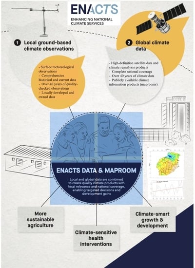
To help meet the current and coming challenges, gaps in climate data and information, as well as in human capacities to take advantage of them, must be filled. With this aim, Columbia University’s International Research Institute for Climate and Society (IRI), in close collaboration with local partners, launched the Enhancing National Climate Services (ENACTS) initiative [
7]. ENACTS is an initiative developed to alleviate the challenges of climate data availability, as well as access and use by supporting countries to generate high-resolution gridded climate data time series and derived climate information products that are readily accessible to decision-makers [
7]. This is accomplished by blending high-quality climate data collected from the national meteorological station network and remote sensing products and climate models reanalysis products [
9]. The results are an over 40-year time series of rainfall and temperature at 4-km or 5-km spatial resolutions.
For many users, the availability of climate data by itself may not lead to the uptake and use of such data. These data must be presented in user-friendly formats addressing specific climate information needs in order to be used for decision-making by governments as well as the public and private sectors. The generated information should also be easily accessible, whether through open websites, public media, or other dedicated delivery channels. Presentation of climate information products in a user-friendly format is the main focus of this paper. The ENACTS approach accomplishes this by creating targeted climate information products, each of which is co-generated and tailored to the requirements of the user, whether that is at a local, national, or international level. These products are made available through an interactive web portal called the “Maproom”. The Maproom is an interactive platform that presents climate information as maps, graphs, and tables at different temporal and spatial scales. Each of the countries (there being over 20 countries, 15 of which are in Africa) where ENACTS has been implemented has its own Maproom. This means that these countries now have over 40 years of temporally and spatially continuous rainfall and temperature time series and an array of climate information products available online through the ENACTS Maprooms hosted by the countries themselves.
2. Materials and Methods
ENACTS enhances the capacity of National Meteorological and Hydrological Services (NMHS) to support the use of climate information in decision-making at local, regional, and national levels. This is accomplished through (i) improving the availability and quality of climate data and information products at local, national, and regional levels; (ii) enhancing access to climate data, information products, and services relevant to the needs of public, national, and local practitioners in climate-sensitive sectors, policymakers, the private sector, and researchers; and (iii) promoting the widespread use of climate information and services by pursuing effective stakeholder engagement and meeting demand for climate information [
7].
2.1. The ENACTS Approach
The ENACTS approach is a multi-faceted initiative designed to bring high-quality, relevant climate knowledge into national decision-making through the improved availability, access, and use of climate data and derived information products.
This is accomplished through three major activities [
7,
10]:
- i.
Improving the availability and quality of climate data;
- ii.
Enhancing access to climate data, information products, and services relevant to the needs of the public;
- iii.
Promoting the widespread use of climate information and services.
The next section describes the first two activities in detail.
2.2. Generation of ENACTS Datasets
The data used within ENACTS Maprooms is obtained using the following steps:
Organizing available climate observations;
Performing quality control of all rainfall and temperature observations from stations in the country/region’s meteorological network; and
Combining the quality-controlled station observations with satellite estimates for rainfall and climate model reanalysis products for temperature.
Rainfall and minimum and maximum temperature observations in the NMHS database are first organized and converted into an appropriate format. The organized data are subjected to rigorous quality control using an in-house tool called Climate Data Tool (CDT;
https://iri.columbia.edu/our-expertise/climate/tools/cdt/, accessed on 10 September 2021). The CDT offers a robust quality check procedure for identifying and correcting erroneous observations. The tool enables checking for a number of error types. The quality check process implemented in CDT includes checking for station coordinates, false zero values for rainfall observations, suspicious observations (outliers) as well as checking for homogeneity in the climate time series.
The tool employs different methods for identifying suspicious values. These include internal consistency checks (an observation is compared with other parameter values to see if they are physically or climatologically consistent); temporal consistency checks (to see if an observation of a given station for a given month is significantly different compared to the long time series); and spatial check (which compares the observation to be checked with the observations from nearby stations or the expected value at the station that is estimated using the observations from neighboring stations).
Combining observations from meteorological stations and proxies such as satellite rainfall estimates or climate model reanalysis products can help overcome the temporal and spatial gaps in station observations. In CDT, satellite rainfall estimates are combined with rain gauge measurements while reanalysis products are used for minimum and maximum temperature. The approach adopted in CDT involves the following steps:
Downscale proxy data (for reanalysis temperature data);
Perform mean bias adjustment; and
Merge the output from the previous step with contemporaneous observations for each time step (day, pentad, dekad, month, etc.).
Reanalysis products are climate-data generated, by systematically combining climate observations (analyses) with climate model forecasts using data assimilation schemes and climate models [
11]. Reanalysis data would need to be downscaled from its coarse resolution to a higher resolution (4 km for ENACTS data). This involves using a digital elevation model (DEM) and station temperature observations to compute downscaling coefficients, which are then applied to time series of reanalysis data.
Bias correction aims to remove the mean bias from proxy data. CDT offers different approaches for mean bias correction, which includes multiplicative bias with variable time step, or for each month, and quantile mapping with a fitted distribution and quantile method with empirical distribution.
The bias-corrected time series of proxy data are merged with contemporaneous station observations to generate spatially and temporally complete (covering the whole country or region and going back as far as possible with data for every time step) climate datasets. For rainfall, the Climate Hazards Group Infrared Precipitation (CHIRPS; [
12]) or Tropical Applications of Meteorology using Satellite data (TAMSAT; [
13]) satellite rainfall estimates are used depending on the performance of those products relative to station observations over the particular country. These two satellite products have been chosen mainly because of their long time series (starting from 1981), high spatial resolution (about 5 km/4 km), and use of consistent satellite sensor (infrared) data throughout the time series. The CHIRPS product is relatively new, while the TAMSAT product has been around since early 1990s. The performance of these satellite products has been evaluated over different parts of Africa, and a good review, including some new validation work, could be found in [
14]. The Japanese 55-year climate model reanalysis (JRA55; [
15]) is used for temperature, mainly because of its long time series (since 1958) and regular updates.
Three different methods are used for merging proxy data with station data, depending on which one offers the best result for the specific countries. These are the Cressman scheme [
16], Barnes scheme [
17], and regression kriging [
18]. These blended datasets provide a 40-year time series of rainfall and over 50 years of temperature time series at high (4 km or 5 km) spatial resolutions. The rainfall time series for all ENACTS countries starts from 1981, while the temperature time series can start from 1961. The latest date of the time series varies from country to country (from 2016 to 2020) depending on when the country updated its data.
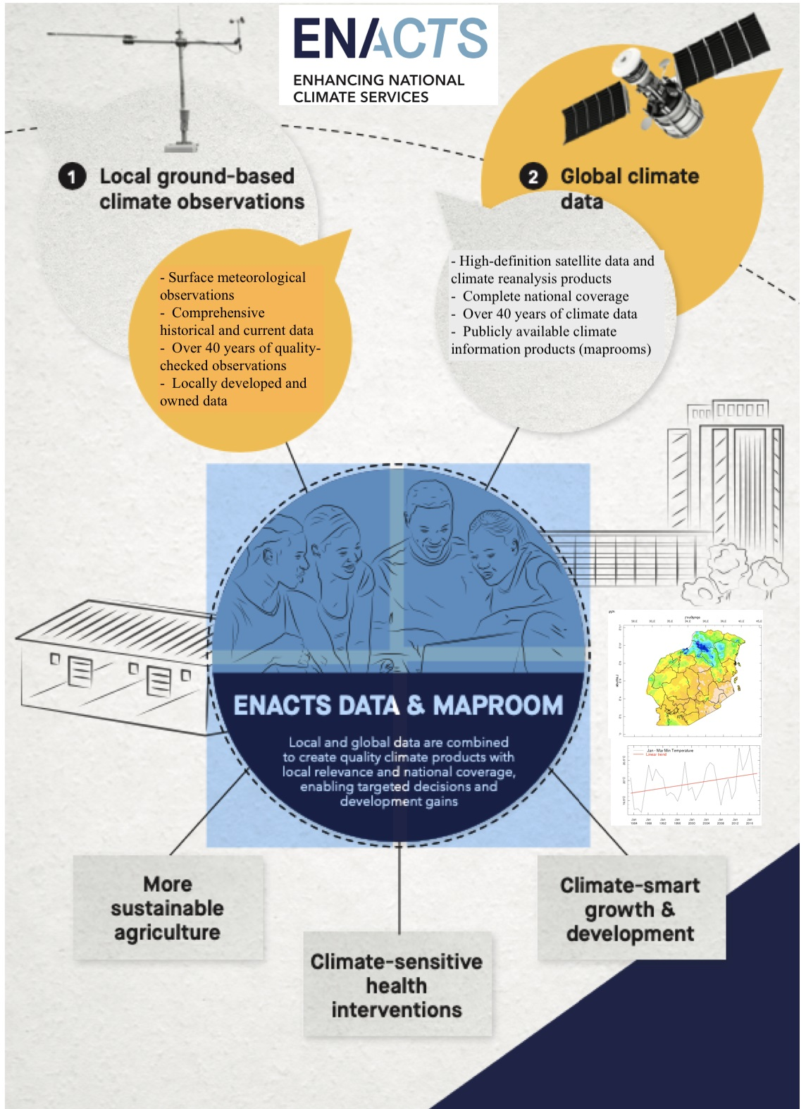
The ENACTS datasets represent a significant improvement over the station-only or proxy-only datasets, depending on the application. The main strength of ENACTS data, compared to other similar globally available products, is that it makes use of all local observational data by working directly with NMHS, which significantly enhances the quality of the generated data relative to the global products [
7]. An example is given in
Figure 1, which compares raingauge stations made available to the world everyday by the Ethiopian National Meteorological Agency through the Global Telecommunications System (GTS) with those used in the ENACTS datasets. Most global satellite products use data from the GTS stations (about 17 while the ETS data incorporates over 500 stations).
2.3. The ENACTS Maproom
Maprooms are online portals where selected information products can be developed and presented for specific users. The ENACTS Maproom is a collection of interactive maps and other figures that enables users to navigate and generate information on past, present, and future climate. The Maproom is dynamic in that the maps and figures are generated by the user on the fly, as the Maprooms are linked to the original climate datasets. This platform offers the functionality to extract and present required information at different temporal (daily to seasonal) and spatial scales (point, box, or administrative or other boundaries). This enables users to focus on a specific area and time window of interest.
The main platform used for the generation and presentation of Maproom products is the IRI Data Library. This is a very powerful and freely accessible online data repository and analysis platform that allows users to view, analyze, and download, and share hundreds of terabytes of multidisciplinary climate-related data through a standard web browser [
19]. It supports Geographic Information System (GIS) capability, is highly interoperable across major data formats and protocols, and is portable to remote sites. The Data Library is then used to develop the online climate information products that make up the Maproom.
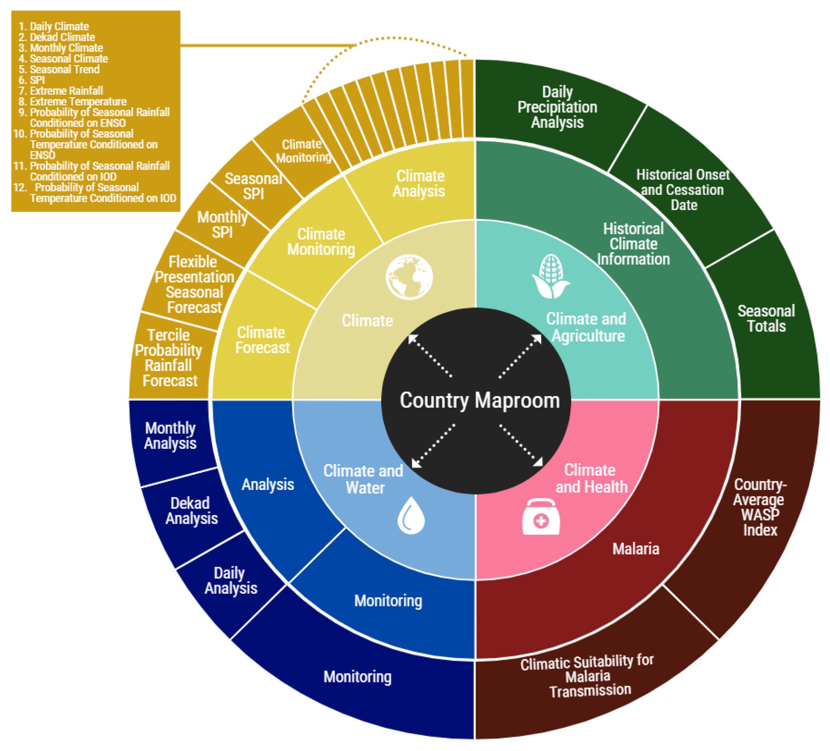
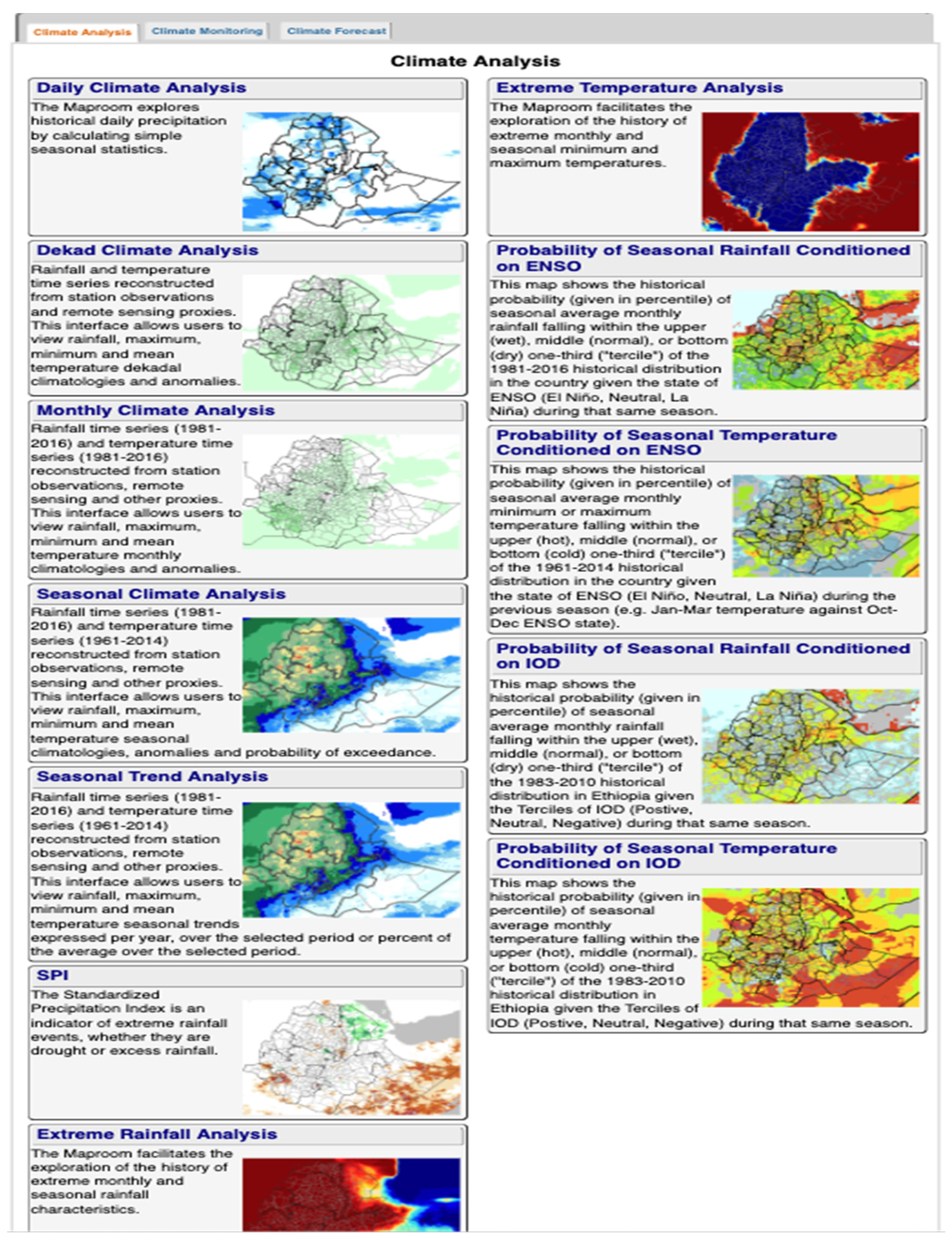
The ENACTS Maproom has been evolving since its first implementation in Ethiopia in 2012, and the current version is composed of the “Climate Maproom” and some application-specific Maprooms. The application-specific Maprooms are “Climate and Agriculture”, “Climate and Health”, and “Climate and Water”. Each of these Maprooms is further divided into sub-maprooms that present different types of climate information products. The overall structure of the Maproom is presented in
Figure 2. However, Maprooms for different ENACTS countries may have slightly different structures based on their needs and where they are in implementing ENACTS.
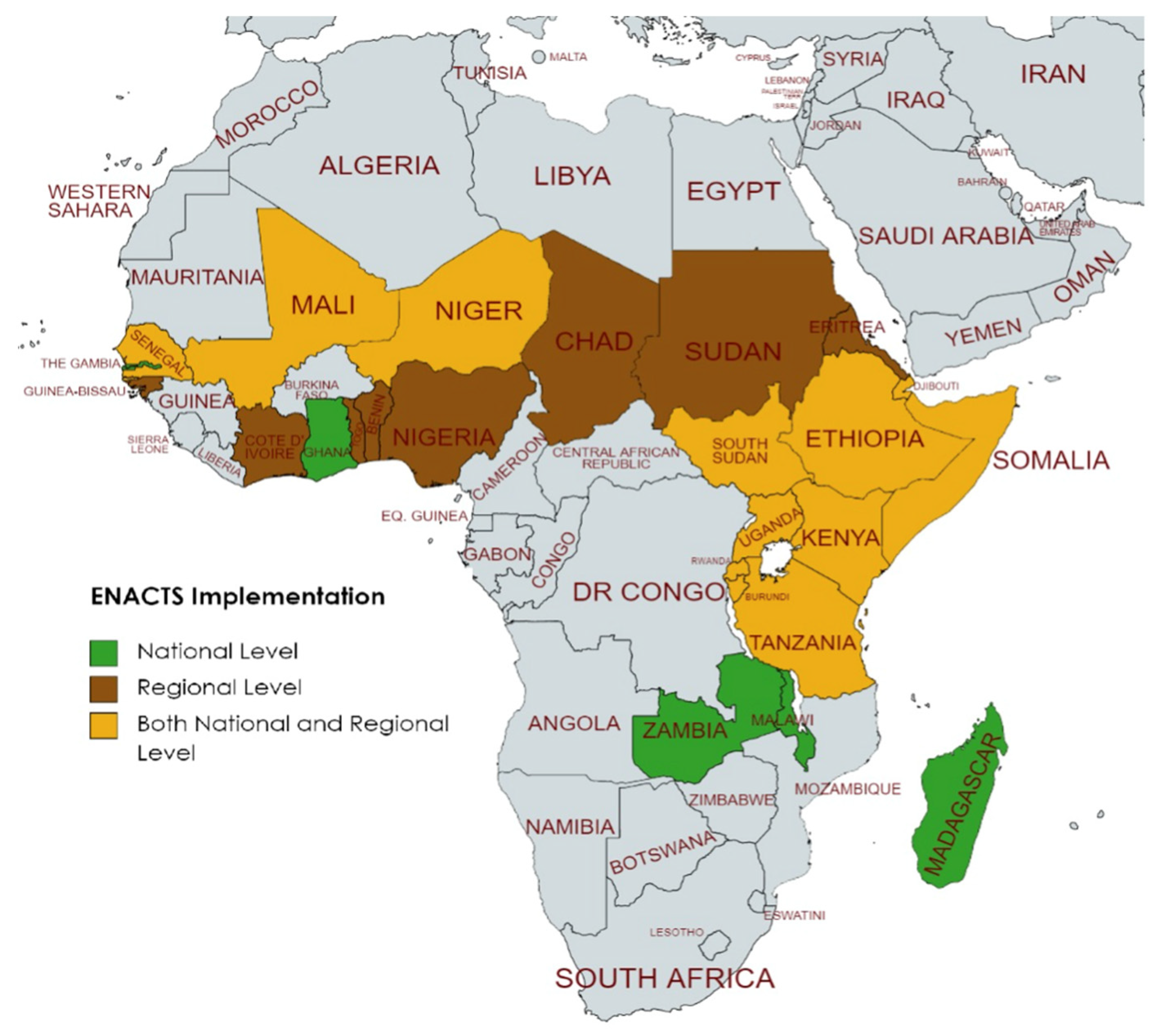
A number of countries across two regions (East and West Africa) have implemented ENACTS (
Figure 3). These countries and regions are now able to deliver robust climate data, targeted information products, and training specifically relevant to their needs. Country Maprooms could be accessed through the NMHS web pages and the IRI ENACTS webpage (
https://iri.columbia.edu/resources/enacts/, accessed on 10 September 2021).
3. Results
This section describes the different components of Maprooms and some of the available products in the ENACTS Maprooms. These maps are also available at a regional level, but this section focuses only on country Maprooms.
3.1. Climate Maproom
The “Climate Maproom” provides an interactive platform for exploring information on the past (historical), present (monitoring), and future (forecast) climate. The historical analyses, based on 30 years of observational data, is presented under the “Climate Analysis Maproom”, monitoring information under the “Climate Monitoring Maproom” and forecast under “Climate Forecast Maproom”. Each of these maprooms are also further divided into thematic tabs. All the sub-maprooms display information as maps, graphs, and tables to allow users to visualize the data to their specific needs.
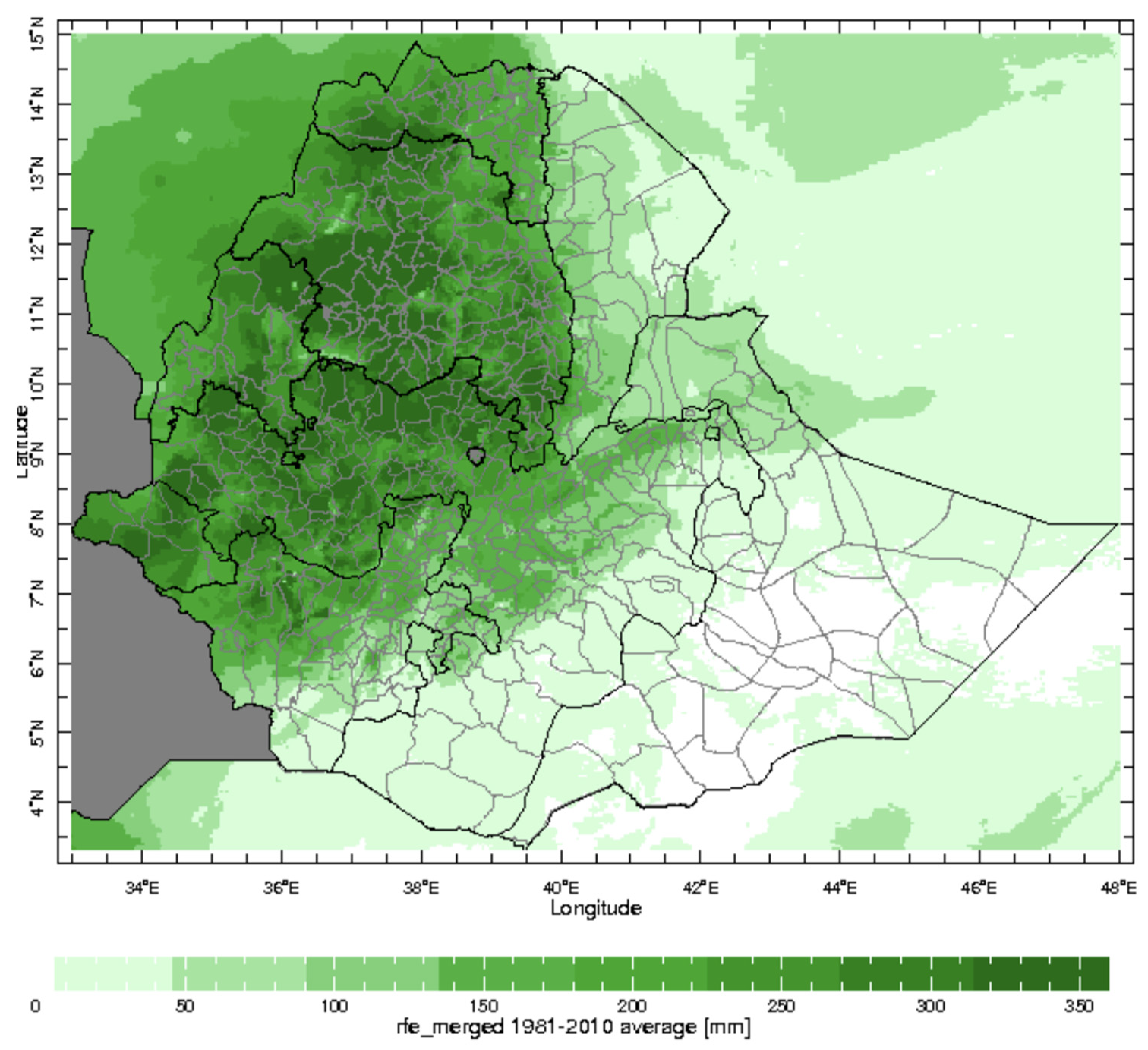
The Climate Analysis Maproom provides information on past climate (in terms of rainfall and temperature) at any point in space and time and at national or subnational levels. With this Maproom, rainfall and temperature data can be presented at different timescales (daily, dekadal [10-day], monthly, and seasonal). Products in this Maproom (
Figure 4) include Daily Analysis (e.g., mean intensity of rainfall, number of wet/dry days, probability of dry/wet spells, and more); Dekadal Analysis (10-day time step); Monthly Analysis, and Seasonal Analysis; as well as, Probability of Seasonal Rainfall/Temperature Conditioned on El Niño Southern Oscillation (ENSO) and the Indian Ocean Dipole (IOD). These probabilities are calculated using the historical rainfall and temperature timeseries over a 30-year period and the historical record of ENSO and IOD states over the same period. The historical climate analyses products in the Climate Analysis Maproom can be used in many different ways that include understanding the drivers of observed climate variability and change. For example, it could help in disentangling whether observed changes in agricultural productivity are linked to variations in climate or some other factor, such as soil degradation. It can also support improving the adaptation of crops, farming systems, and agricultural support to local climatic risks by analyzing the seasonality, trends, and variability.
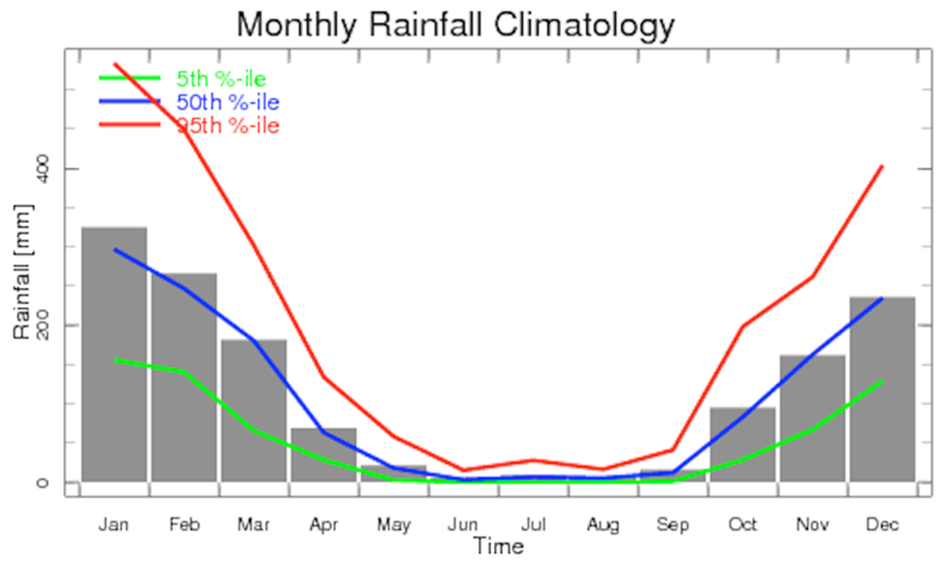
For instance, the monthly analysis allows users to view rainfall and temperature monthly climatology as well as seasonality. The monthly analysis could be used to characterize the climate of an area including a spatial
distribution of rainfall or temperature during a specific month (
Figure 5) or seasonality (month-to-month variations) for a specific location (
Figure 6) during the year.
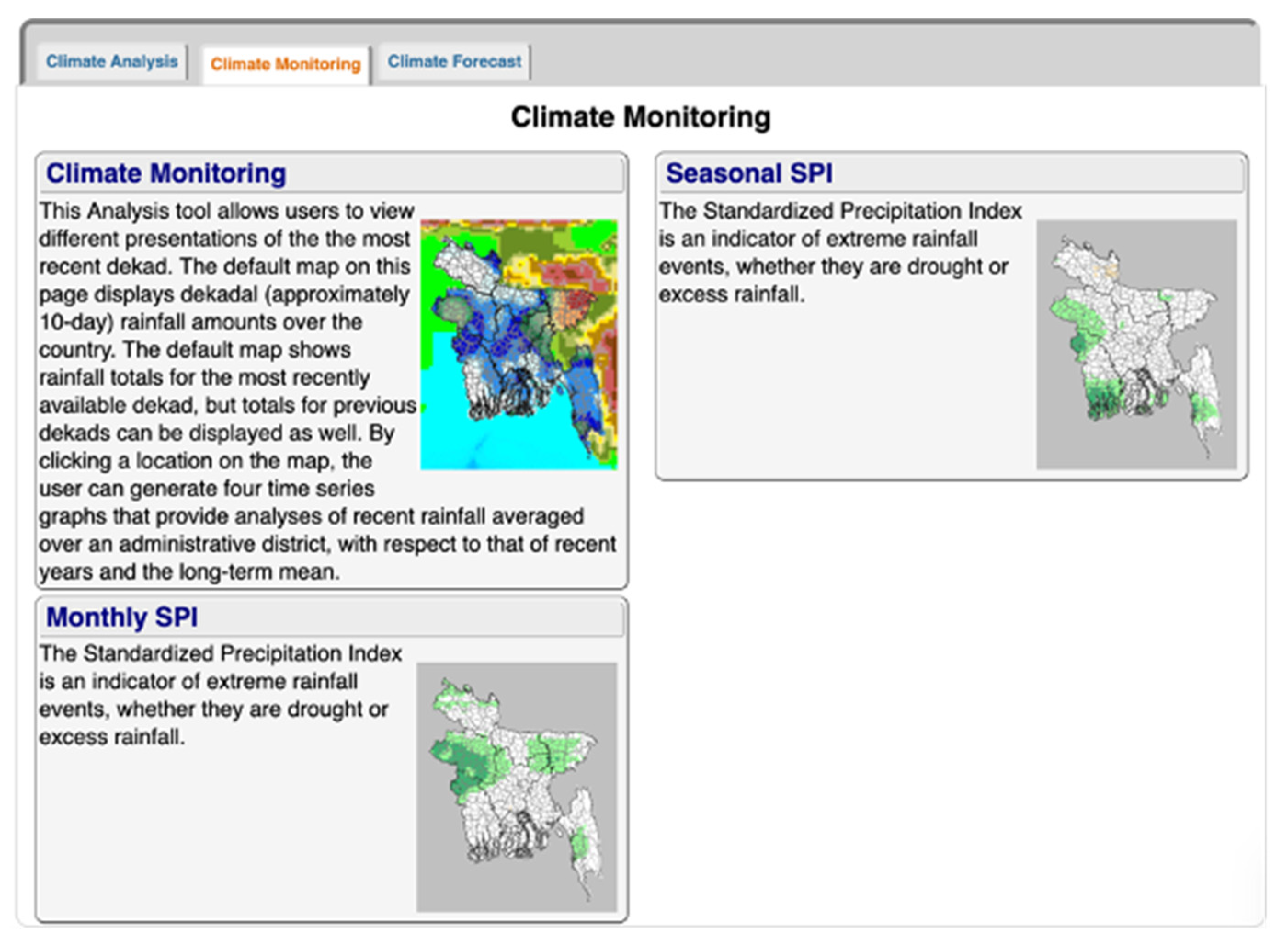
The Climate Monitoring Maproom enables monitoring of the current season at dekadal, monthly, and seasonal time scales (
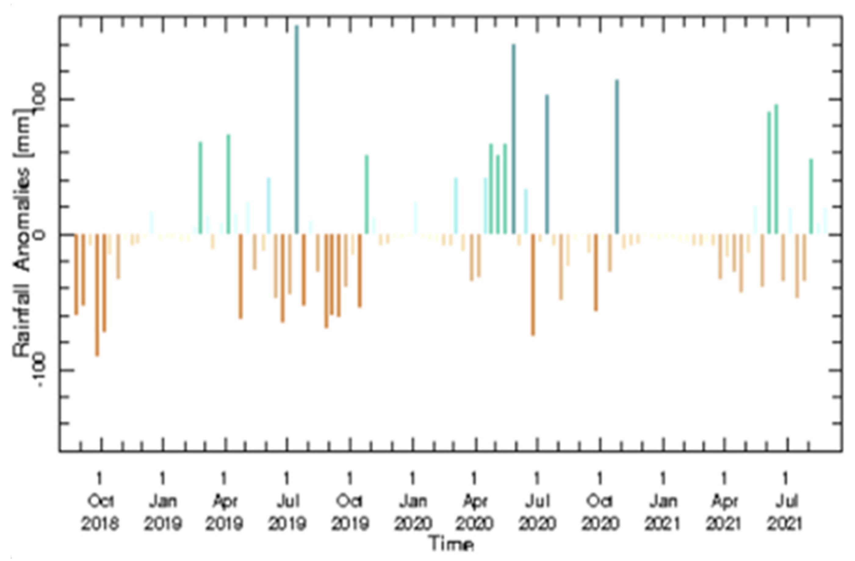
Figure 7). Different maps and graphs provided in this Maproom are used to compare the current season with what is expected or with recent years. Information can be extracted at any location (point) or for administrative or other boundaries (
Figure 8). This Maproom has sub-components that allow users to analyze the data at different temporal and spatial scales. Available analyses include dekadal, monthly, and seasonal anomalies, as well as extreme rainfall events.
Figure 7 shows the tabs in the Climate Monitoring Maproom.
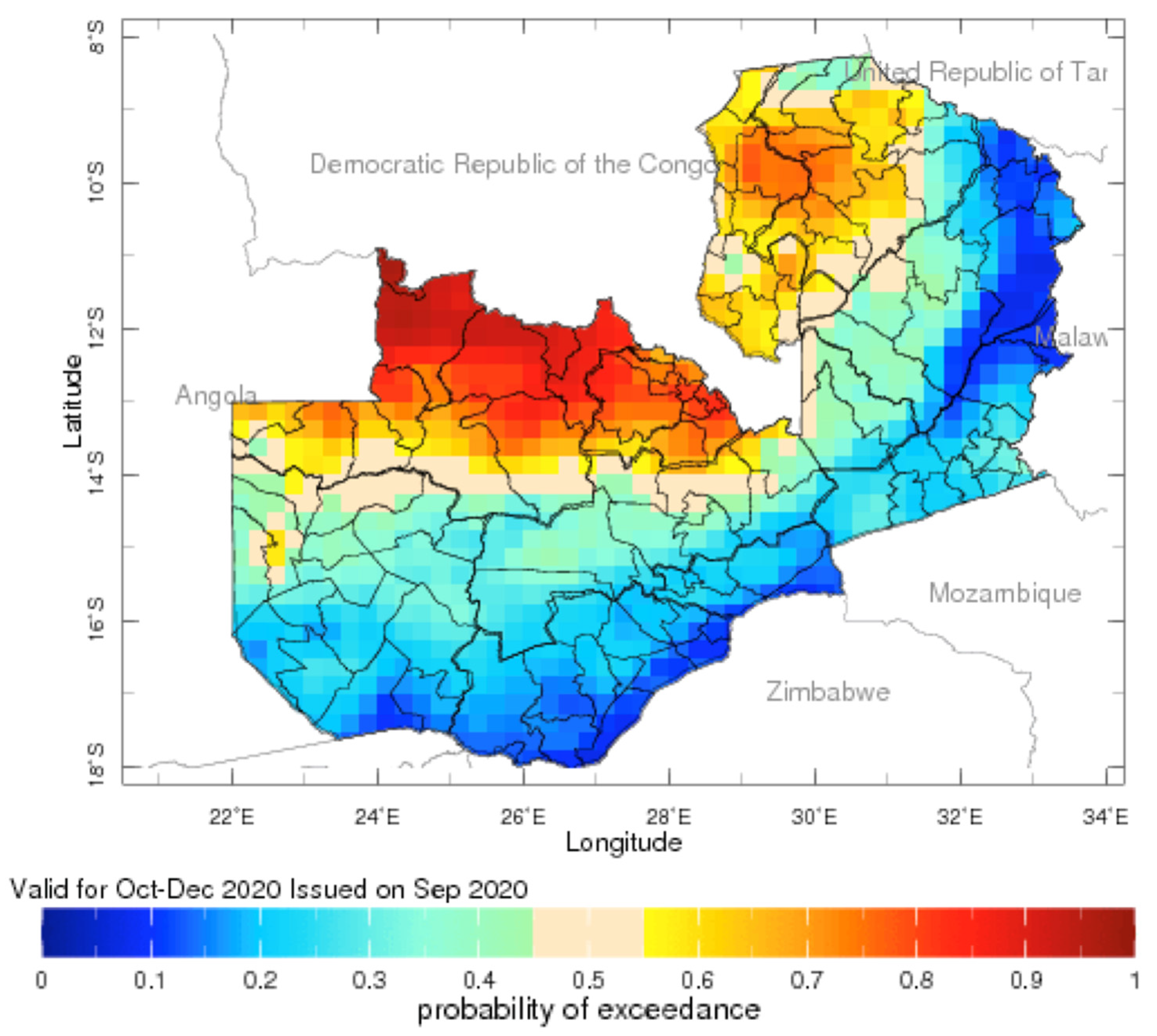
The Climate Forecast Maproom presents seasonal rainfall forecasts in a flexible format that can be easily understood and customized by users. Instead of the usual terciles (below normal, normal, and above normal) presentation, this Maproom allows users to choose a threshold they are interested in, either as percentiles or rainfall amounts. For instance, one can explore the probability that the total rainfall for the coming season is predicted to be above or below 350 mm (
Figure 9). The Maproom also presents location-specific climate forecast information, displayed as exceedance graphs or probability density function, that can help users to assess what the next season might bring and plan accordingly.
3.2. Application-Specific Maprooms
The application-specific Maprooms currently include the Climate and Agriculture, Climate and Health, and Climate and Water Maprooms. These Maprooms have been developed through a consultation process with experts and other users forming the different sectors in different countries.
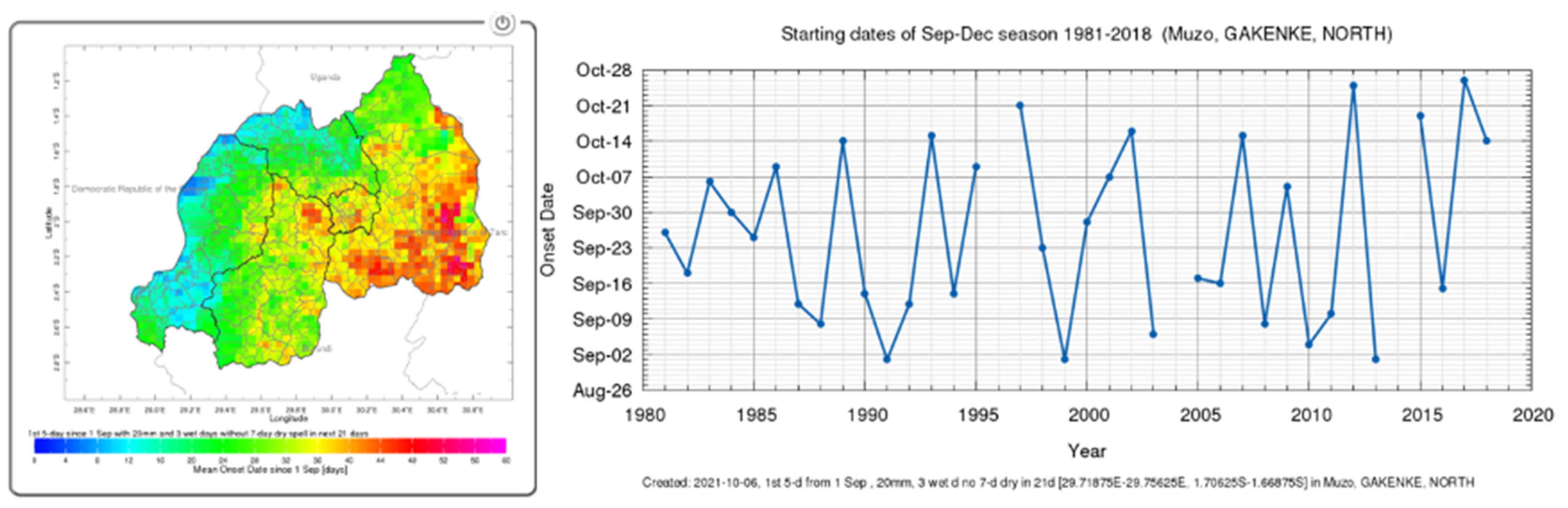
The Climate and Agriculture Maproom enables analysis of historical daily rainfall to compute agriculture-relevant variables, such as probability of having a certain number of wet or dry days in a given season, the start (onset) and end (cessation) dates of the rainy season, as well as the length of the rainy season. Among these climate information products, those particularly relevant for agriculture are the onset, cessation, and length of the season. Onset date is the start of the rainy season as identified by agronomic criterion, which often includes passing a certain threshold in cumulative rain over a few days and not being followed by a long break in rain (dry spells), which could damage germinating crops. Cessation date is the date when the season is assumed to end and is based on the available soil moisture. This information is displayed as maps or graphs, as shown in
Figure 10. The information in this Maproom may help farmers in making decisions in their agriculture planning and practice. These decisions may include when to plant or apply fertilizer or pesticides, and how to select other suitable practices to optimize crop growth under different climatic conditions.
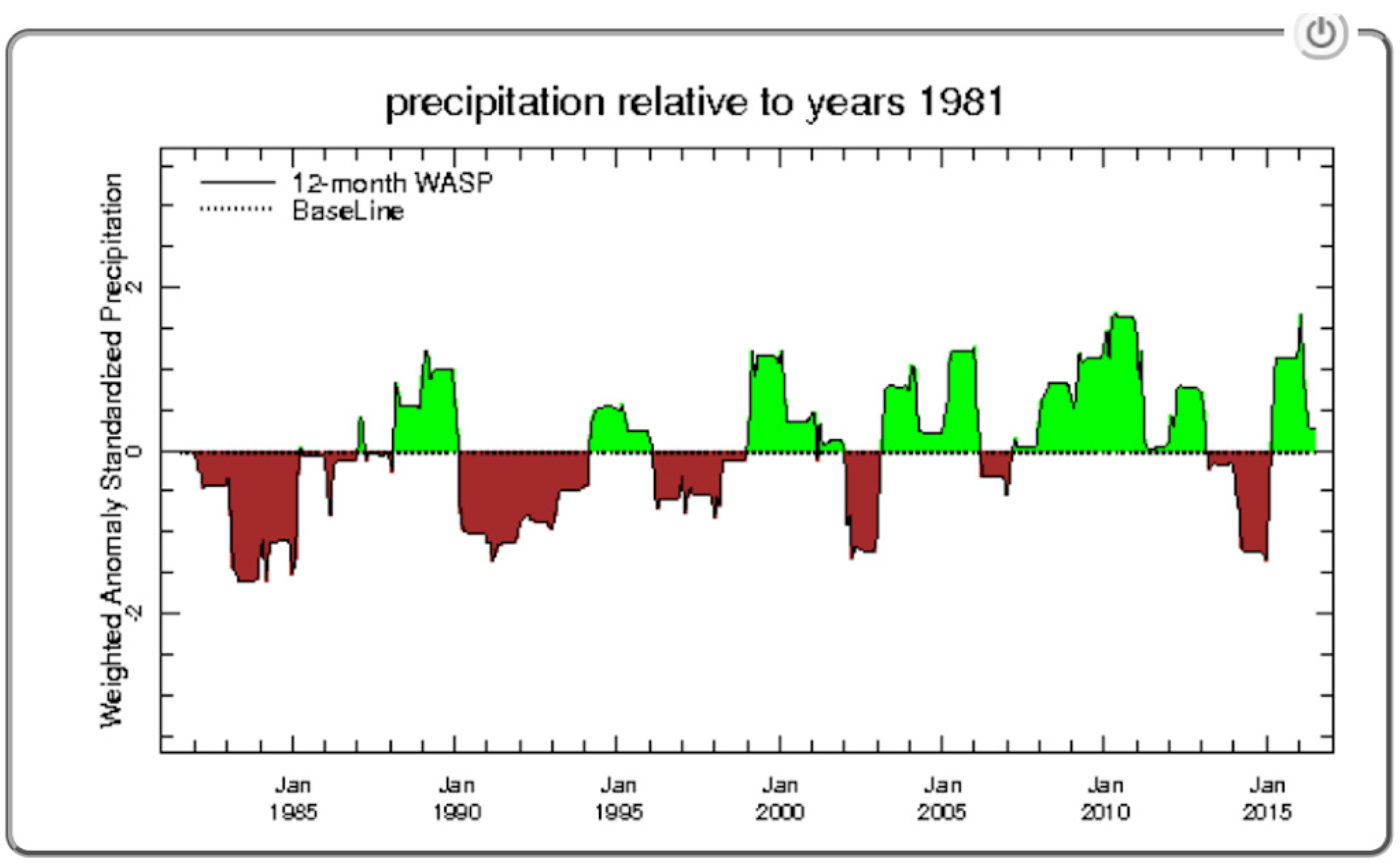
The Climate and Health Maproom provides users with a tool to explore the link between climate and health, specifically for malaria risk. However, many of the climate information products in the other Maprooms, such as the Extreme Rainfall/Temperature Analysis, could also be very useful for health professionals. The main products in this Maproom are the seasonal Climate Suitability for Malaria Transmission (CSMT), presented as a map (
Figure 11) or graphs, and the Weighted Anomaly Standardization Precipitation (WASP) index presented as a graph (
Figure 12). The CSMT, which is derived from thresholds of precipitation, temperature, and relative humidity, is used for identifying where and when the climate is suitable for malaria transmission. This can help public health policymakers and practitioners on planning and executing malaria control and elimination programs.
The main purpose of WASP products (
Figure 12) is to provide a simple visual means of relating averaged precipitation to a reference period of interest. The reference period could be either the average of many years or a specific year of interest. Precipitation, especially in hot dryland areas, is the main factor responsible for creating the conditions that may lead to the formation of sufficient surface water and moisture for mosquito breeding. A baseline above (below) 0 indicates the selected year or period of recorded precipitation being above (below) the long-term average for the selected year of interest. Similarly, a baseline below 0 indicates the selected year or period of recorded precipitation being below the long-term average for the selected year of interest.
The Climate and Water Maproom provides some relevant products for historical analysis, monitoring the current season, and anticipating the coming season. This Maproom is just the Climate Maproom analyzed at a water shade or sub-watershed level, as opposed to an administrative level. The products in this Maproom could be used to understand rainfall trends over a given catchment area, exploring probability of having a drought/flood over the catchment during a given season, or identifying occurrence of dry/wet days during a given season. For instance, historical climate data can be used to plan dam construction, while climate monitoring and forecasts can support dam operations.
4. Discussion
Availability of and access to climate data is beneficial for research and applications such as agriculture and other climate-sensitive economic activities. However, availability of climate data has been a serious challenge in Africa and many and other parts of the world. Even when the data does exist, access is often limited, mainly because of the data sharing policies of many NMHS. On the other hand, availability of climate data by itself may not lead to the uptake and use of data. Climate data must be translated into decision-relevant information that can address specific climate information needs. The generated information should also be easily accessible through open websites or other delivery channels. The ENACTS approach has been intentional in ensuring that data are transformed and tailored into actionable and decision-relevant information for a wide variety of users, in making this information freely accessible, and in promoting the broad dissemination and use. This is accomplished by creating targeted climate information products (maprooms), which are tailored to the requirements of the user, whether that is at a local, national, or regional level. An important component in ensuring the usefulness of climate information products generated by ENACTS is the process of engagement with users. Instead of a one-way push, the approach involves a two-way iterative and collaborative process. As a result, most of ENACTS maproom products, particularly the application-specific ones, have been developed or improved based on user requests and feedbacks.
The ENACTS approach has transformed access to climate information products where it has been implemented. The array of climate information products made available by NMHS through the ENACTS maprooms is unprecedented, even in many developed parts of the world. These products could support many economic activities through the use of climate information for climate risk management and adaptations to the long-term climate change. However, more efforts are needed to ensure the use of these maprooms. Many of the NMHS, who were expected to promote the use of these products, have been very slow mainly because these products are outside of what these NMHS used to provide to users. Thus, there are some learning curves for the NMS themselves who are used to providing only limited climate information products, such as weather and seasonal forecasts. Thus, the ENACTS team has now started engagement with and capacity building for the user community, mainly for agriculture and disaster early warning sectors.
The other aspect of this work is sustainability. These maprooms are developed through a specific donor-funded project and the NMS, as well as users, would need continued technical support and engagement to continue maintaining the system and providing the information users are now used to. As ENACS has been implemented in so many countries, this would be a daunting task for one institution alone and can only be achieved and sustained through broad partnership. The ENACTS team attempts to ensure sustainability and cost-effectiveness by building ENACTS–related expertise at the Regional Climate Centers (RCC) in Africa. The ultimate goal is to transfer all operational ENACTS activities to the RCC and limit IRI’s role to technical support to the regional centers, developing and refining tools and products, supporting innovations, and facilitating engagements with users. This has already started at the IGAD Climate Prediction and Application Center (ICPAC) in East Africa and at the Agrometeorology, Hydrology, and Meteorology (AGRHYMET) Regional Center in West Africa. ICPAC has already started developing its own suite of country specific maprooms with limited IRI support, which is a great success from a sustainability perspective.
5. Summary
Climate information can help in making climate-sensitive economic activities more resilient to current climate extremes and adapting to the changing climate. Quality climate data are the foundations for the generation of climate information products. However, conventional meteorological observation networks over many parts of the world are seriously inadequate, and have been declining, particularly over most of Africa. Access and use of available climate data have been an additional challenge. Satellite rainfall estimates could be extremely useful as they provide information that complements and/or supplements the sparse and declining meteorological observation network. The Enhancing National Climate Services (ENACTS) approach has been a challenge to improving data availability, as well as access to and use of derived climate information products. This is accomplished by generating a temporally and spatially complete climate time series, by blending satellite rainfall estimates with station rainfall observation, and by blending temperature products from climate reanalysis with station temperature observations. These data are then used to create an array of climate information products (as maps and graphs) that are made available through an interactive web interface called the Maproom. These information products support a suite of climate-smart solutions that reinforce development gains and improve the lives of those most vulnerable to climate variability and change. The ENACTS initiative has been implemented in over 20 countries around the world, including over 15 countries in Africa. These countries have generated over 40 years of temporally and spatially continuous rainfall and temperature time series and provide an array of decision-relevant climate information products through their Maprooms.
Author Contributions
Formal analysis, R.C., I.K., A.V. and R.F.; Methodology, T.D.; Project administration, G.N.; Supervision, T.D.; Writing—original draft, G.N. and T.D.; Writing—review & editing, A.G. All authors have read and agreed to the published version of the manuscript.
Funding
This research received no external funding.
Acknowledgments
This work is undertaken as part of the Columbia World Project, ACToday, Columbia University in the City of New York. The authors would like to acknowledge the critical contribution of over 15 National Meteorological Agencies as well as two Regional Climate Centers who participated in the implementation of ENACTS.
Conflicts of Interest
The authors declare no conflict of interest.
References
- Burton, I.; Huq, S.; Lim, B.; Pilifosova, O.; Schipper, E.L. From impacts assessment to adaptation priorities: The shaping of adaptation policy. Clim. Policy 2002, 2, 145–159. [Google Scholar] [CrossRef] [Green Version]
- World Meteorological Organization. Agriculture and Food Security Exemplar to the User Interface Platform of the Global Framework for Climate Services; World Meteorological Organization: Geneva, Switzerland, 2014; p. 35. [Google Scholar]
- Hansen, J.W.; Zebiak, S.; Coffey, K. Shaping global agendas on climate risk management and climate services: An IRI perspective. Earth Perspect. 2014, 1, 13. [Google Scholar] [CrossRef] [Green Version]
- Daron, J.; Lorenz, S.; Wolski, P.; Blamey, R.; Jack, C. Interpreting climate data visualisations to inform adaptation decisions. Clim. Risk Manag. 2015, 10, 17–26. [Google Scholar] [CrossRef] [Green Version]
- Cooper, P.; Dimes, J.; Rao, K.; Shapiro, B.; Shiferaw, B.; Twomlow, S. Coping better with current climatic variability in the rain-fed farming systems of sub-Saharan Africa: An essential first step in adapting to future climate change? Agric. Ecosyst. Environ. 2008, 126, 24–35. [Google Scholar] [CrossRef] [Green Version]
- Dinku, T. Challenges with availability and quality of climate data in Africa. In Extreme Hydrology and Climate Variability; Assefa, M.M., Wossenu, A., Gabriel, S., Eds.; Elsevier: Amsterdam, The Netherlands, 2019; Chapter 7; pp. 71–80. [Google Scholar] [CrossRef]
- Dinku, T.; Thomson, M.C.; Cousin, R.; del Corral, J.; Ceccato, P.; Hansen, J.; Connor, S.J. Enhancing National Climate Services (ENACTS) for development in Africa. Clim. Dev. 2018, 10, 664–672. [Google Scholar] [CrossRef]
- Washington, R.; Harrison, M.; Conway, D.; Black, E.; Challinor, A.; Grimes, D.; Jones, R.; Morse, A.; Kay, G.; Todd, M. AF-RICAN CLIMATE CHANGE: Taking the Shorter Route. Bull. Am. Meteorol. Soc. 2006, 87, 1355–1366. Available online: http://0-www-jstor-org.brum.beds.ac.uk/stable/26217216 (accessed on 16 September 2021). [CrossRef]
- Dinku, T.; Hailemariam, K.; Maidment, R.; Tarnavsky, E.; Connor, S. Combined use of satellite estimates and rain gauge observations to generate high-quality historical rainfall time series over Ethiopia. Int. J. Clim. 2014, 34, 2489–2504. [Google Scholar] [CrossRef] [Green Version]
- Dinku, T.; Block, P.; Sharoff, J.; Hailemariam, K.; OsGood, D.E.; Del Corral, J.; Cousin, R.; Thomson, M.C. Bridging critical gaps in climate services and applications in africa. Earth Perspect. 2014, 1, 15. [Google Scholar] [CrossRef] [Green Version]
- Zhao, T.; Fu, C.; Ke, Z.; Guo, W. Global Atmosphere Reanalysis Datasets: Current Status and Recent Advances. Adv. Earth Sci. 2010, 25, 241–254. Available online: http://www.adearth.ac.cn/EN/10.11867/j.issn.1001-8166.2010.03.0241 (accessed on 19 November 2021).
- Funk, C.; Peterson, P.; Landsfeld, M.; Pedreros, D.; Verdin, J.; Shukla, S.; Husak, G.; Rowland, J.; Harrison, L.; Hoell, A.; et al. The climate hazards infrared precipitation with stations—A new environmental record for monitoring extremes. Sci. Data 2015, 2, 150066. [Google Scholar] [CrossRef] [PubMed] [Green Version]
- Maidment, R.I.; Grimes, D.; Allan, R.P.; Tarnavsky, E.; Stringer, M.; Hewison, T.; Roebeling, R.; Black, E. The 30 year TAMSAT African Rainfall Climatology And Time series (TARCAT) data set. J. Geophys. Res. Atmos. 2014, 119, 10619–10644. [Google Scholar] [CrossRef] [Green Version]
- Dinku, T. Remote sensing of african rainfall. In Oxford Research Encyclopedia of Climate Science; Oxford University Press: Oxford, UK, 2020. [Google Scholar] [CrossRef]
- Kobayashi, S.; Ota, Y.; Harada, Y.; Ebita, A.; Moriya, M.; Onoda, H.; Onogi, K.; Kamahori, H.; Kobayashi, C.; Endo, H.; et al. The JRA-55 Reanalysis: General Specifications and Basic Characteristics. J. Meteorol. Soc. Jpn. 2015, 93, 5–48. [Google Scholar] [CrossRef] [Green Version]
- Mateus, P.; Borma, L.S.; Da Silva, R.D.; Nico, G.; Catalão, J. Assessment of two techniques to merge ground-based and TRMM rainfall measurements: A case study about Brazilian Amazon Rainforest. GIScience Remote Sens. 2016, 53, 689–706. [Google Scholar] [CrossRef]
- Rozante, J.R.; Moreira, D.S.; de Goncalves, L.G.; Vila, D. Combining TRMM and Surface Observations of Precipitation: Technique and Validation over South America. Weather. Forecast. 2010, 25, 885–894. Available online: http://ezproxy.cul.columbia.edu/login?url=https://www-proquest-com.ezproxy.cul.columbia.edu/scholarly-journals/combining-trmm-surface-observations-precipitation/docview/597142967/se-2?accountid=10226 (accessed on 16 September 2021). [CrossRef] [Green Version]
- Sekulić, A.; Kilibarda, M.; Protić, D.; Tadić, M.P.; Bajat, B. Spatio-temporal regression kriging model of mean daily temperature for Croatia. Theor. Appl. Clim. 2019, 140, 101–114. Available online: Link.gale.com/apps/doc/A618498864/AONE?u=columbiau&sid=summon&xid=76329f54 (accessed on 22 September 2021). [CrossRef]
- Blumenthal, M.B.; Bell, M.; Del Corral, J.; Cousin, R.; Khomyakov, I. IRI Data Library: Enhancing Accessibility of Climate Knowledge. Earth Perspect. 2014, 1, 19. [Google Scholar] [CrossRef] [Green Version]
Figure 1.
Comparison of GTS (Global Telecommunications System) station distribution (left) and stations used in ENACTS (Enhancing National Climate Services) data (right) for Ethiopia. Most global satellite rainfall estimates incorporate only data from the GTS stations.
Figure 1.
Comparison of GTS (Global Telecommunications System) station distribution (left) and stations used in ENACTS (Enhancing National Climate Services) data (right) for Ethiopia. Most global satellite rainfall estimates incorporate only data from the GTS stations.
Figure 2.
Circular diagram showing the sub-maprooms of the ENACTS Maproom, potential uses, and the related products in concentric circles. Different sub (branch) maprooms are observed as one goes out from the center of the circle.
Figure 2.
Circular diagram showing the sub-maprooms of the ENACTS Maproom, potential uses, and the related products in concentric circles. Different sub (branch) maprooms are observed as one goes out from the center of the circle.
Figure 3.
Countries and regions where ENACTS has been implemented or is in the process of being implemented. The brown color shows where ENACTS has been implemented at the regional level, while the green color shows where ENACTS has been implemented only at the national level. Countries in orange are those in which ENACTS has been implemented both at the regional and the national levels.
Figure 4.
An example of the “Climate Analysis” maproom for Ethiopia.
Figure 4.
An example of the “Climate Analysis” maproom for Ethiopia.
Figure 5.
Rainfall climatology (normal) during the month of July over Ethiopia.
Figure 5.
Rainfall climatology (normal) during the month of July over Ethiopia.
Figure 6.
Seasonality of rainfall for a specific location over Madagascar. The bars show the mean rainfall (climatology) for each month, while green, blue, and red lines show the 5th, 50th, and 95th percentiles, respectively. The 5th and 95th percentiles are included here to show the minimum and maximum ranges (variance) of the temperature.
Figure 7.
An example of the Climate Monitoring Maproom for Bangladesh. The map on the top left shows dekadal rainfall total for a given 10-day period, while the other two maps show monthly and seasonal SPI (Standard Precipitation Index), which is a measure of extreme wetness (green colors) or dryness (brown colors).
Figure 8.
Dekadal rainfall anomalies for the selected region over Bangladesh over the last 3 years. For each year, the bars show whether dekadal rainfall for a given year was above normal (brown colors) or below normal (green colors). The length of the bars shows how much below or above normal the seasonal rainfall for a given year was.
Figure 9.
Probability that the October-November-December 2020 seasonal rainfall total over Zambia, forecasted in September 2020, will exceed 350 mm.
Figure 9.
Probability that the October-November-December 2020 seasonal rainfall total over Zambia, forecasted in September 2020, will exceed 350 mm.
Figure 10.
Onset dates displayed as a map for Rwanda (left) and as a time series graph for a specific location in Rwanda (right).
Figure 10.
Onset dates displayed as a map for Rwanda (left) and as a time series graph for a specific location in Rwanda (right).
Figure 11.
Number of months when the climate is suitable for malaria transmission over Senegal.
Figure 11.
Number of months when the climate is suitable for malaria transmission over Senegal.
Figure 12.
Country Average Weighted Anomaly Standardization Precipitation (WASP) for Senegal.
Figure 12.
Country Average Weighted Anomaly Standardization Precipitation (WASP) for Senegal.
| Publisher’s Note: MDPI stays neutral with regard to jurisdictional claims in published maps and institutional affiliations. |
© 2021 by the authors. Licensee MDPI, Basel, Switzerland. This article is an open access article distributed under the terms and conditions of the Creative Commons Attribution (CC BY) license (https://creativecommons.org/licenses/by/4.0/).


 ,
, 


