
Shore Evidences of a High Antarctic Ocean Wave Event: Geomorphology, Event Reconstruction and Coast Dynamics through a Remote Sensing Approach


Abstract
:
1. Introduction
2. Materials and Methods
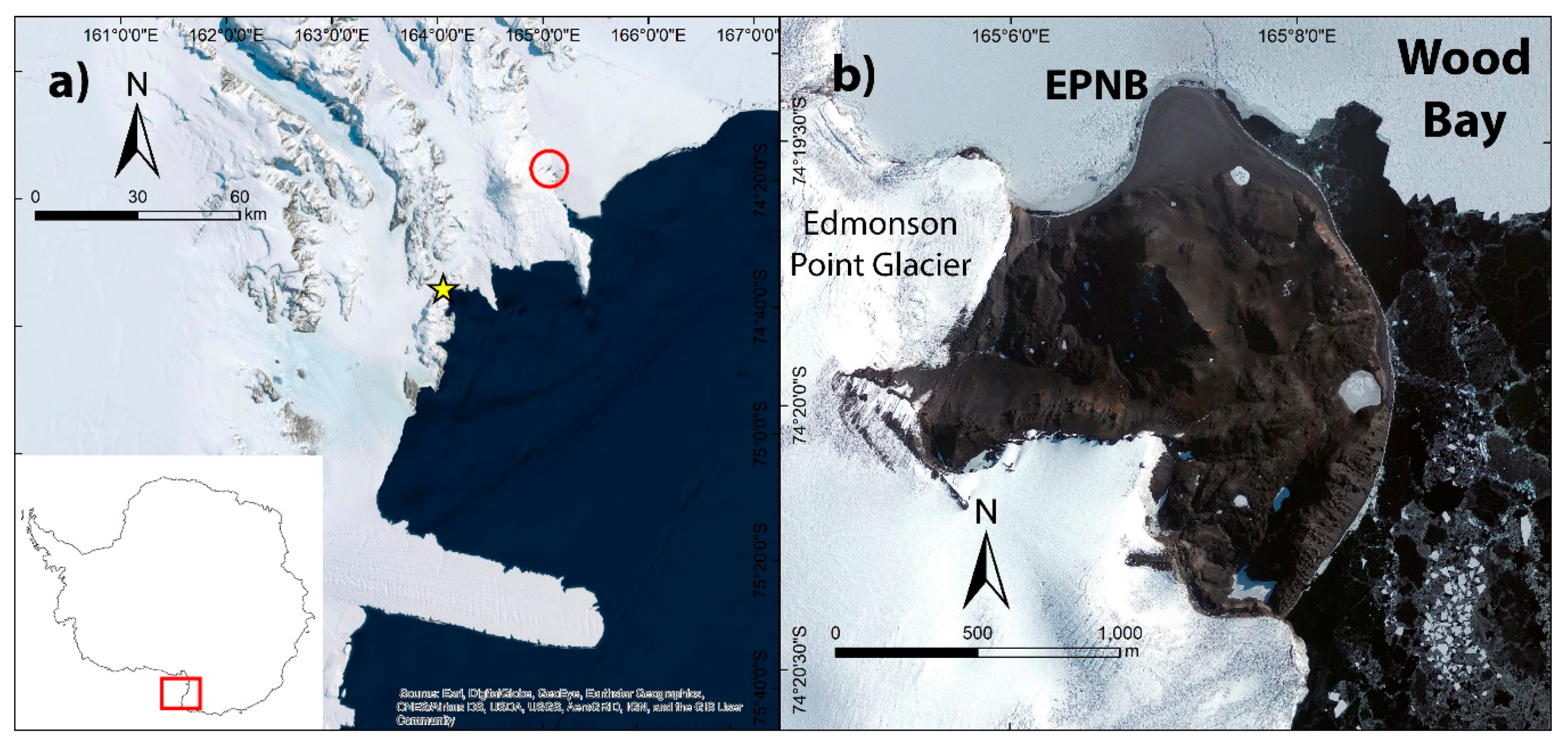
2.1. Study Area
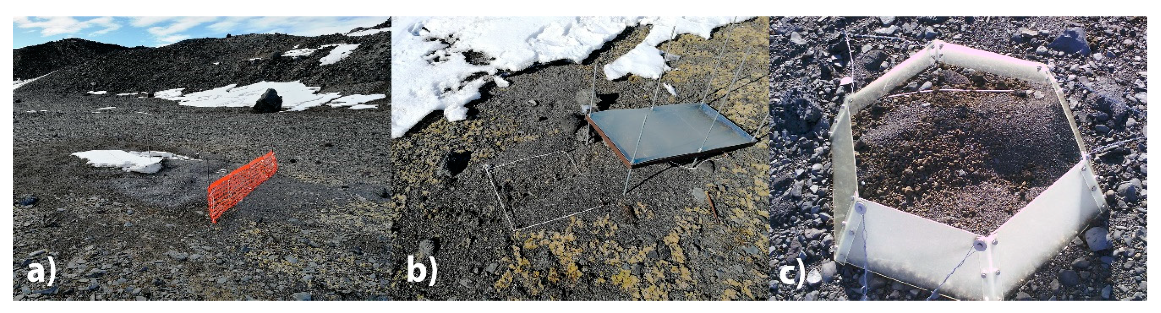
2.2. Field Data and Morphometry
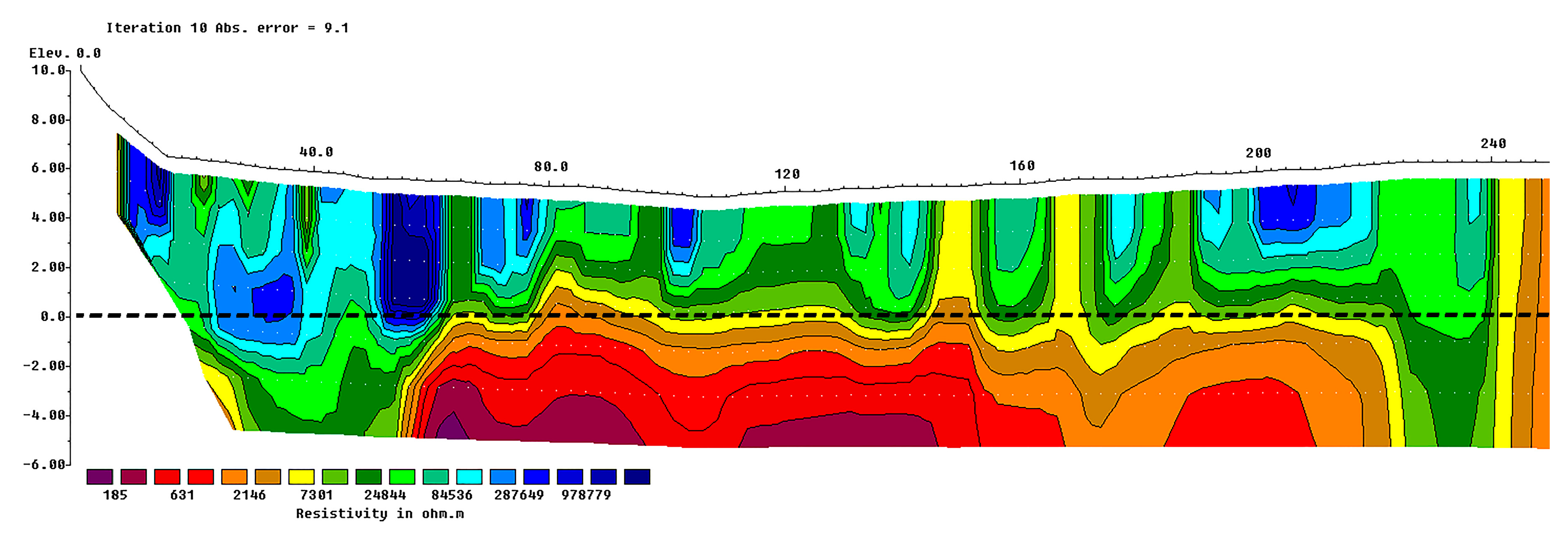
2.3. Aerial Survey
2.4. Satellite Data and High Oceanic Wave Event Reconstruction
3. Results
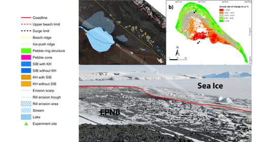
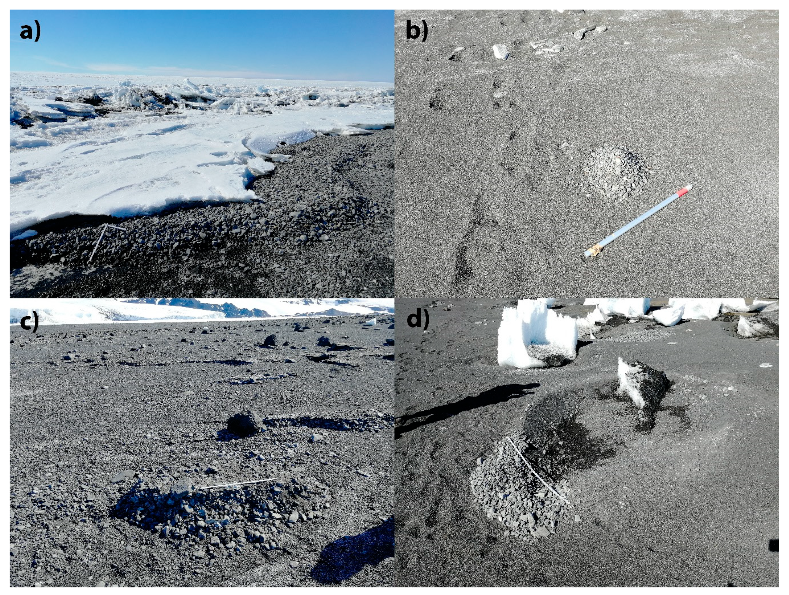
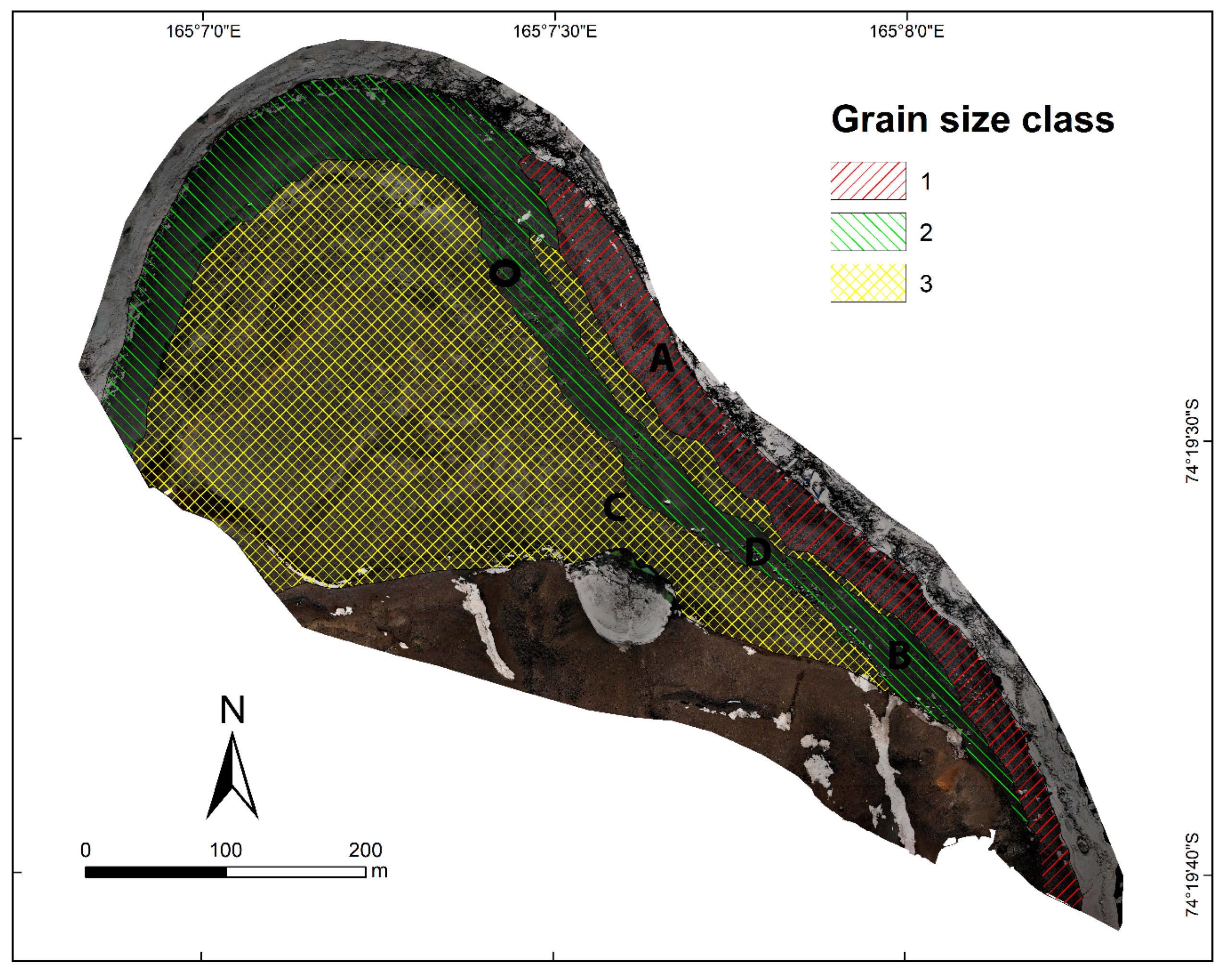
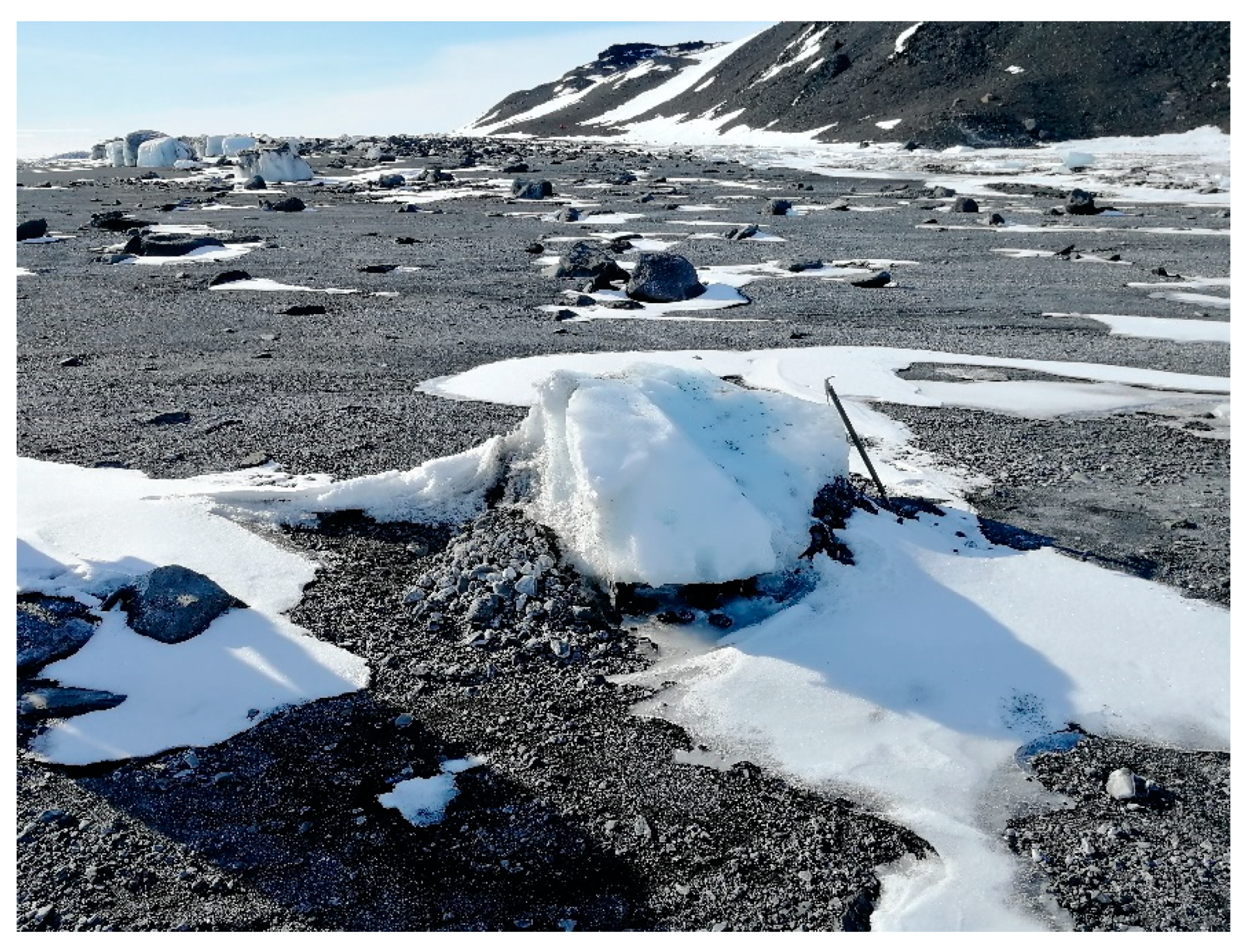
3.1. Geomorphology
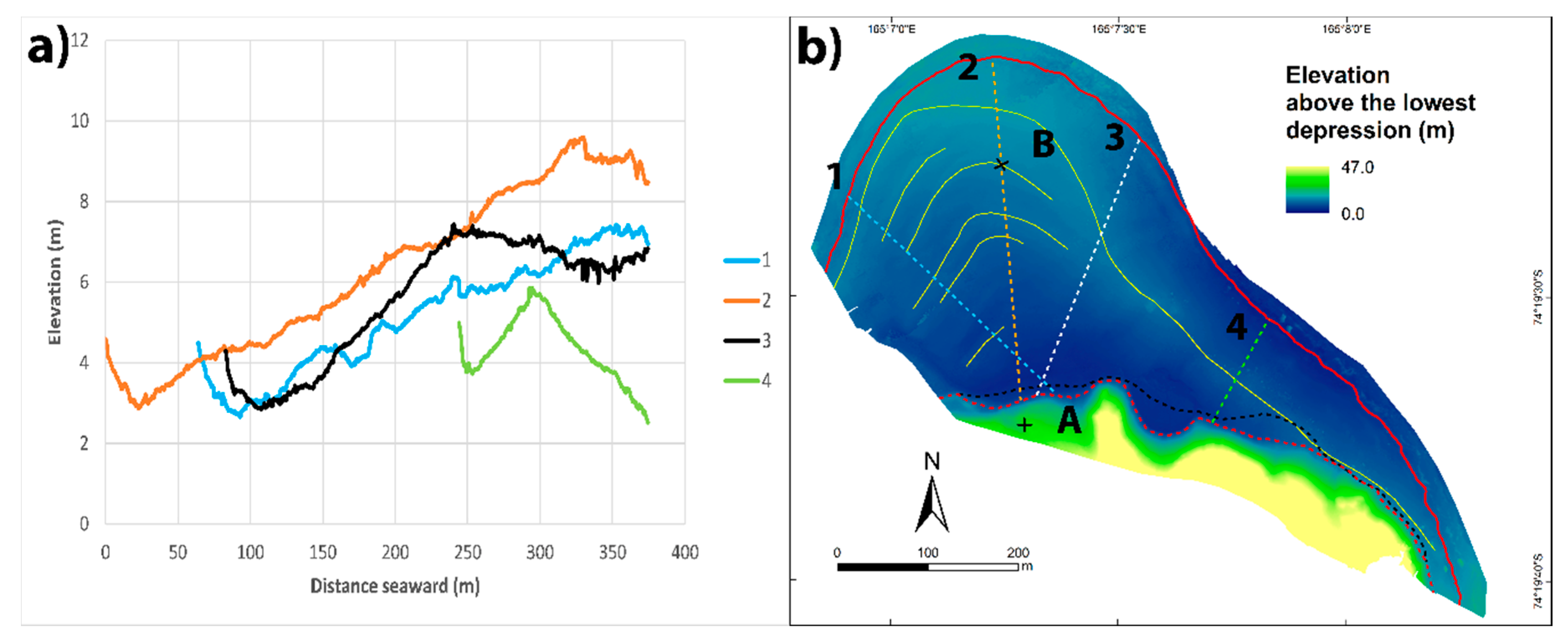
3.2. Morphometry
3.3. High Oceanic Wave Event Reconstruction
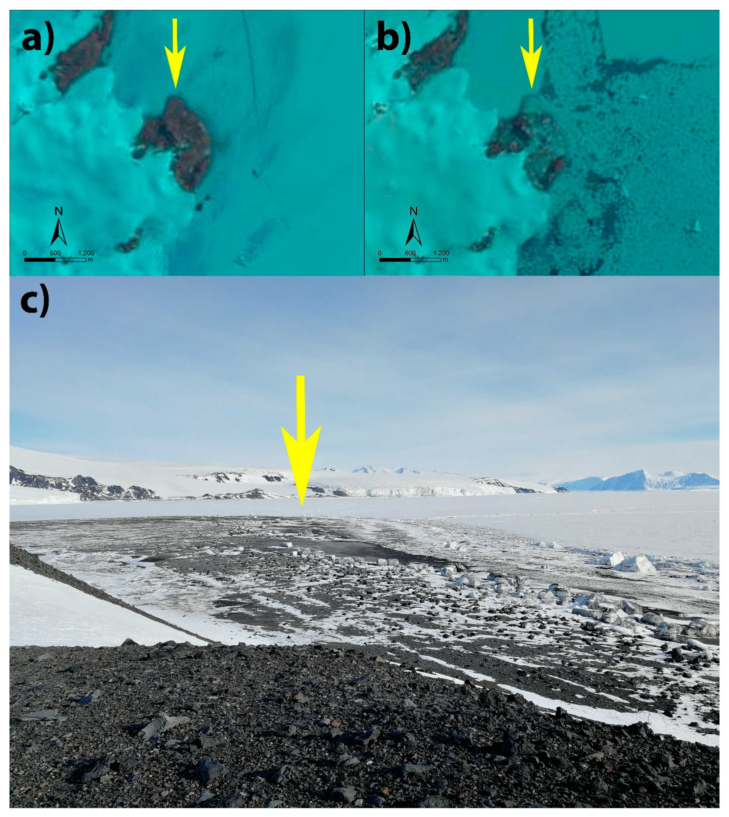
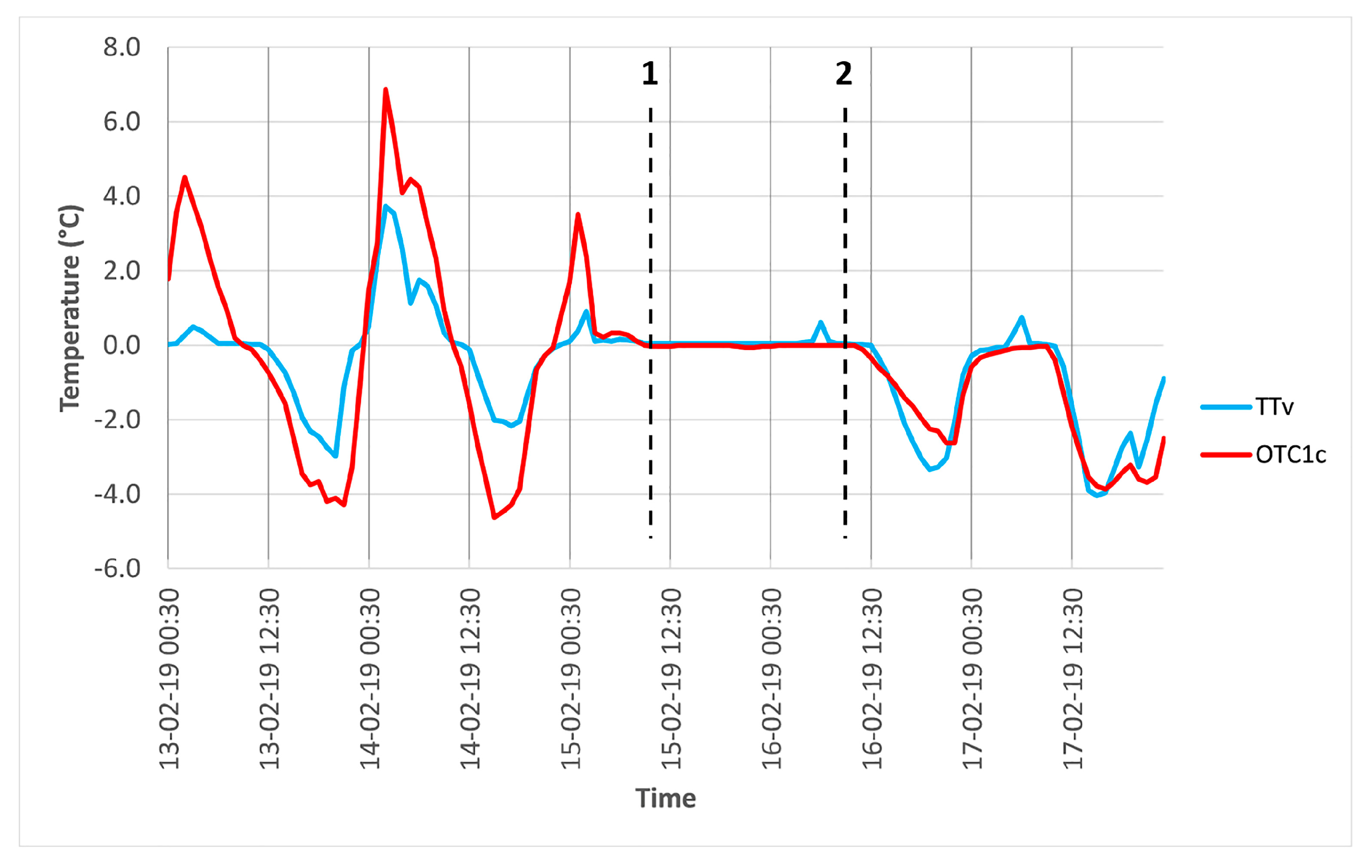
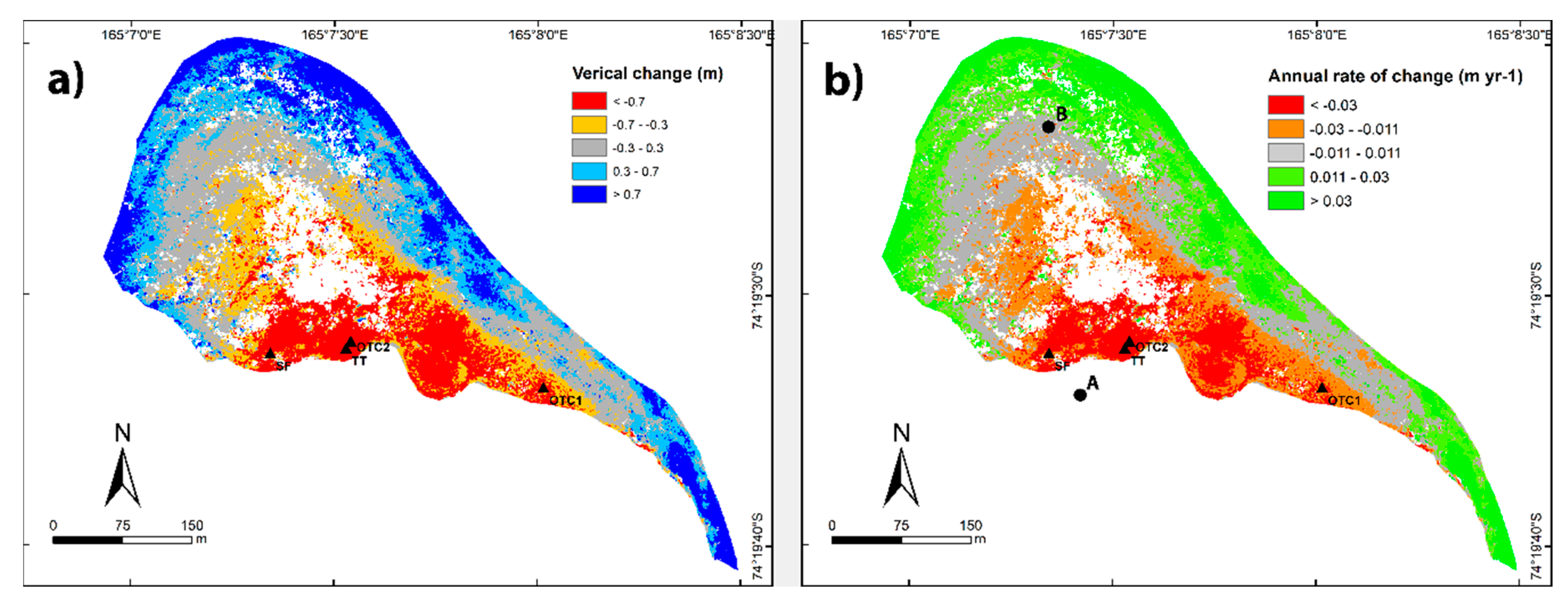
3.4. Coast Dynamics
4. Discussion
4.1. Geomorphology and Morphometry
4.2. High Oceanic Wave Event Reconstruction
4.3. Coast Dynamics
5. Conclusions
Author Contributions
Funding
Data Availability Statement
Acknowledgments
Conflicts of Interest
References
- UNEP. Marine and Coastal Ecosystems and Human Well-Being: A Synthesis Report Based on The Findings of The Millennium Ecosystem Assessment; UNEP: Nairobi, Kenya, 2006. [Google Scholar]
- Toimil, A.; Losada, I.J.; Camus, P.; Díaz-Simal, P. Managing coastal erosion under climate change at the regional scale. Coast. Eng. 2017, 128, 106–122. [Google Scholar] [CrossRef]
- De Winter, R.C.; Ruessink, B.G. Sensitivity analysis of climate change impacts on dune erosion: Case study for the Dutch Holland coast. Clim. Chang. 2017, 14, 685–701. [Google Scholar] [CrossRef] [Green Version]
- Doyle, T.W.; Day, R.H.; Biagas, J.M. Predicting coastal retreat in the Florida Big Bend region of the Gulf Coast under climate change induced sea-level rise. In Integrated Assessment of the Climate Change Impacts on the Gulf Coast Region; Gulf Coast Climate Change Assessment Council (GCRCC); Louisiana State University Graphic Services: Trenton, OH, USA, 2003; pp. 201–209. [Google Scholar]
- Enríquez, A.R.; Marcos, M.; Álvarez-Ellacuría, A.; Orfila, A.; Gomis, D. Changes in beach shoreline due to sea level rise and waves under climate change scenarios: Application to the Balearic Islands (western Mediterranean). Nat. Hazards Earth Syst. Sci. 2017, 17, 1075–1089. [Google Scholar] [CrossRef] [Green Version]
- Mehvar, S.; Filatova, T.; Sarker, M.H.; Dastgheib, A.; Ranasinghe, R. Climate change-driven losses in ecosystem services of coastal wetlands: A case study in the West coast of Bangladesh. Ocean Coast. Manag. 2019, 169, 273–283. [Google Scholar] [CrossRef]
- Orford, J.D. Proposed mechanism for storm beach sedimentation. Earth Surf. Process. 1977, 2, 381–400. [Google Scholar] [CrossRef]
- Are, F.; Reimnitz, E.; Grigoriev, M.; Hubberten, H.W.; Rachold, V. The influence of cryogenic processes on the erosional Arctic shoreface. J. Coast. Res. 2008, 24, 110–121. [Google Scholar] [CrossRef]
- Farquharson, L.M.; Mann, D.H.; Swanson, D.K.; Jones, B.M.; Buzard, R.M.; Jordan, J.W. Temporal and spatial variability in coastline response to declining sea-ice in northwest Alaska. Mar. Geol. 2018, 404, 71–83. [Google Scholar] [CrossRef]
- Lim, M.; Whalen, D.; Martin, J.; Mann, P.J.; Hayes, S.; Fraser, P.; Berry, H.B.; Ouellette, D. Massive Ice Control on Permafrost Coast Erosion and Sensitivity. Geophys. Res. Lett. 2020, 47, e2020GL087917. [Google Scholar] [CrossRef]
- Sinitsyn, A.O.; Guegan, E.; Shabanova, N.; Kokin, O.; Ogorodov, S. Fifty four years of coastal erosion and hydrometeorological parameters in the Varandey region, Barents Sea. Coast. Eng. 2020, 157, 103610. [Google Scholar] [CrossRef]
- Zmarz, A.; Rodzewicz, M.; Dąbski, M.; Karsznia, I.; Korczak-Abshire, M.; Chwedorzewska, K.J. Application of UAV BVLOS remote sensing data for multi-faceted analysis of Antarctic ecosystem. Remote Sens. Environ. 2018, 217, 375–388. [Google Scholar] [CrossRef]
- Guégan, E.; Sinitsyn, A.; Kokin, O.; Ogorodov, S. Coastal Geomorphology and Ground Thermal Regime of the Varandey Area, Northern Russia. J. Coast. Res. 2016, 32, 1025–1031. [Google Scholar] [CrossRef]
- Couture, N.J.; Irrgang, A.; Pollard, W.; Lantuit, H.; Fritz, M. Coastal Erosion of Permafrost Soils Along the Yukon Coastal Plain and Fluxes of Organic Carbon to the Canadian Beaufort Sea. J. Geophys. Res. Biogeosci. 2018, 132, 406–422. [Google Scholar] [CrossRef]
- Radosavljevic, B.; Lantuit, H.; Pollard, W.; Overduin, P.; Couture, N.; Sachs, T.; Helm, V.; Fritz, M. Erosion and Flooding—Threats to Coastal Infrastructure in the Arctic: A Case Study from Herschel Island, Yukon Territory, Canada. Estuaries Coasts 2016, 39, 900–915. [Google Scholar] [CrossRef] [Green Version]
- St-Hilaire-gravel, D.; Bell, T.J.; Forbes, D.L. Raised gravel beaches as proxy indicators of past sea-ice and wave conditions, Lowther island, Canadian Arctic Archipelago. Arctic 2010, 213–226. [Google Scholar] [CrossRef] [Green Version]
- Forbes, D.L.; Taylor, R.B. Ice in the shore zone and the geomorphology of cold coasts. Prog. Phys. Geogr. 1994, 18, 59–89. [Google Scholar] [CrossRef]
- Gardner, N.; Hall, B.; Wehmiller, J. Pre-Holocene raised beaches at Cape Ross, Southern Victoria Land, Antarctica. Mar. Geol. 2006, 229, 273–284. [Google Scholar] [CrossRef]
- Mason, O.K. Beach ridge geomorphology at Cape Grinnell, northern Greenland: A less icy arctic in the mid-holocene. Geogr. Tidsskr. 2010, 110, 337–355. [Google Scholar] [CrossRef]
- Barnhart, K.R.; Anderson, R.S.; Overeem, I.; Wobus, C.; Clow, G.D.; Urban, F.E. Modeling erosion of ice-rich permafrost bluffs along the Alaskan Beaufort Sea coast. J. Geophys. Res. Earth Surf. 2014, 119, 1155–1179. [Google Scholar] [CrossRef]
- Cunliffe, A.; Tanski, G.; Radosavljevic, B.; Palmer, W.; Sachs, T.; Lantuit, H.; Kerby, J.; Myers-Smith, I. Rapid retreat of permafrost coastline observed with aerial drone photogrammetry. Cryosphere 2019, 13, 1513–1528. [Google Scholar] [CrossRef] [Green Version]
- Solomon, S.M. Spatial and temporal variability of shoreline change in the Beaufort-Mackenzie region, northwest territories, Canada. Geo-Marine Lett. 2005, 25, 127–137. [Google Scholar] [CrossRef]
- Atkinson, D.E. Observed storminess patterns and trends in the circum-Arctic coastal regime. Geo-Marine Lett. 2005, 25, 98–109. [Google Scholar] [CrossRef]
- Lindhorst, S.; Schutter, I. Polar gravel beach-ridge systems: Sedimentary architecture, genesis, and implications for climate reconstructions (South Shetland Islands/Western Antarctic Peninsula). Geomorphology 2014, 221, 187–203. [Google Scholar] [CrossRef]
- Lantuit, H.; Overduin, P.P.; Couture, N.; Wetterich, S.; Aré, F.; Atkinson, D.; Brown, J.; Cherkashov, G.; Drozdov, D.; Donald Forbes, L.; et al. The Arctic Coastal Dynamics Database: A New Classification Scheme and Statistics on Arctic Permafrost Coastlines. Estuaries Coasts 2012, 35, 383–400. [Google Scholar] [CrossRef] [Green Version]
- Dayton, P.K.; Hammerstrom, K.; Jarrell, S.C.; Kim, S.; Nordhausen, W.; Osborne, D.J.; Thrush, S.F. Unusual coastal flood impacts in Salmon Valley, McMurdo Sound, Antarctica. Antarct. Sci. 2016, 28, 269. [Google Scholar] [CrossRef]
- Simeoni, U.; Baroni, C.; Meccheri, M.; Taviani, M.; Zanon, G. Coastal studies in Northern Victoria Land (Antarctica): Holocene beaches of Inexpressible Island, Thetys Bay and Edmonson Point. Boll. Oceanol. Teor. Appl. 1989, 7, 5–17. [Google Scholar]
- Barnhart, K.R.; Overeem, I.; Anderson, R.S. The effect of changing sea ice on the physical vulnerability of Arctic coasts. Cryosphere 2014, 8, 1777–1799. [Google Scholar] [CrossRef] [Green Version]
- Simkins, L.M.; Simms, A.R.; Dewitt, R. Assessing the link between coastal morphology, wave energy and sea ice throughout the Holocene from Antarctic raised beaches. J. Quat. Sci. 2015, 30, 335–348. [Google Scholar] [CrossRef]
- Butler, E.R.T. Process environments on modern and raised beaches in McMurdo Sound, Antarctica. Mar. Geol. 1999, 162, 105–120. [Google Scholar] [CrossRef]
- Hall, B.L.; Baroni, C.; Denton, G.H. Holocene relative sea-level history of the Southern Victoria Land Coast, Antarctica. Glob. Planet. Chang. 2004, 42, 241–263. [Google Scholar] [CrossRef]
- Thomas, I.D.; King, M.A.; Bentley, M.J.; Whitehouse, P.L.; Penna, N.T.; Williams, S.D.P.; Riva, R.E.M.; Lavallee, D.A.; Clarke, P.J.; King, E.C.; et al. Widespread low rates of Antarctic glacial isostatic adjustment revealed by GPS observations. Geophys. Res. Lett. 2011, 38. [Google Scholar] [CrossRef] [Green Version]
- Whitehouse, P.L.; Bentley, M.J.; Milne, G.A.; King, M.A.; Thomas, I.D. A new glacial isostatic adjustment model for Antarctica: Calibrated and tested using observations of relative sea-level change and present-day uplift rates. Geophys. J. Int. 2012, 190, 1464–1482. [Google Scholar] [CrossRef] [Green Version]
- Fretwell, P.T.; Hodgson, D.A.; Watcham, E.P.; Bentley, M.J.; Roberts, S.J. Holocene isostatic uplift of the South Shetland Islands, Antarctic Peninsula, modelled from raised beaches. Quat. Sci. Rev. 2010, 29, 1880–1893. [Google Scholar] [CrossRef]
- Baroni, C.; Orombelli, G. Holocene raised beaches at Terra Nova Bay, Victoria Land, Antarctica. Quat. Res. 1991, 36, 157–177. [Google Scholar] [CrossRef]
- Colhoun, E.A.; Mabin, M.C.G.; Adamson, D.A.; Kirk, R.M. Antarctic ice volume and contribution to sea-level fall at 20,000 yr BP from raised beaches. Nature 1992, 358, 316–319. [Google Scholar] [CrossRef]
- Baroni, C.; Hall, B.L. A new Holocene relative sea-level curve for Terra Nova Bay, Victoria Land, Antarctica. J. Quat. Sci. 2004, 19, 377–396. [Google Scholar] [CrossRef]
- Schmid, T.; López-Martínez, J.; Guillaso, S.; Serrano, E.; D’Hondt, O.; Koch, M.; Nieto, A.; O’Neill, T.; Mink, S.; Durán, J.J.; et al. Geomorphological mapping of ice-free areas using polarimetric RADARSAT-2 data on Fildes Peninsula and Ardley Island, Antarctica. Geomorphology 2017, 293, 448–459. [Google Scholar] [CrossRef]
- Torrecillas, C.; Berrocoso, M.; Pérez-López, R.; Torrecillas, M.D. Determination of volumetric variations and coastal changes due to historical volcanic eruptions using historical maps and remote-sensing at Deception Island (West-Antarctica). Geomorphology 2012, 136, 6–14. [Google Scholar] [CrossRef]
- Kim, M.; Im, J.; Han, H.; Kim, J.; Lee, S.; Shin, M.; Kim, H.C. Landfast sea ice monitoring using multisensor fusion in the Antarctic. GISci. Remote Sens. 2015, 52, 239–256. [Google Scholar] [CrossRef]
- Jawak, S.D.; Raut, D.A.; Luis, A.J. Iterative Spectral Index Ratio Exploration for Object-based Image Analysis of Antarctic Coastal Oasis Using High Resolution Satellite Remote Sensing Data. Aquat. Procedia 2015, 4, 157–164. [Google Scholar] [CrossRef]
- Lucieer, A.; Turner, D.; King, D.H.; Robinson, S.A. Using an unmanned aerial vehicle (UAV) to capture micro-topography of antarctic moss beds. Int. J. Appl. Earth Obs. Geoinf. 2014, 27, 53–62. [Google Scholar] [CrossRef] [Green Version]
- Li, T.; Zhang, B.; Cheng, X.; Westoby, M.J.; Li, Z.; Ma, C.; Hui, F.; Shokr, M.; Liu, Y.; Chen, Z.; et al. Resolving fine-scale surface features on polar sea ice: A first assessment of UAS photogrammetry without ground control. Remote Sens. 2019, 11, 784. [Google Scholar] [CrossRef] [Green Version]
- Byun, D.S.; Hart, D.E. Predicting tidal heights for extreme environments: From 25 h observations to accurate predictions at Jang Bogo Antarctic Research Station, Ross Sea, Antarctica. Ocean Sci. 2020, 16, 1111–1124. [Google Scholar] [CrossRef]
- Baroni, C.; Orombelli, G. Holocene glacier variations in the Terra Nova Bay area (Victoria Land, Antarctica). Antarct. Sci. 1994, 6, 497–505. [Google Scholar] [CrossRef]
- French, H.M.; Guglielmin, M. Observations on the ice-marginal, periglacial geomorphology of Terra Nova Bay, Northern Victoria Land, Antarctica. Permafr. Periglac. Process. 1999, 10, 331–347. [Google Scholar] [CrossRef]
- Smykla, J.; Drewnik, M.; Szarek-Gwiazda, E.; Hii, Y.S.; Knap, W.; Emslie, S.D. Variation in the characteristics and development of soils at Edmonson Point due to abiotic and biotic factors, northern Victoria Land, Antarctica. Catena 2015, 132, 56–67. [Google Scholar] [CrossRef]
- Antarctic Treaty Consultative Meeting Management Plan for Antarctic Specially Protected Area No. 165 EDMON-SON POINT, WOOD BAY, VICTORIA LAND, ROSS SEA. In Proceedings of the ATCM XXIX, Edinburgh, UK, 12–23 June 2006; p. 31.
- Scarchilli, C.; Ciardini, V.; Grigioni, P.; Iaccarino, A.; De Silvestri, L.; Proposito, M.; Dolci, S.; Camporeale, G.; Schioppo, R.; Antonelli, A.; et al. Characterization of snowfall estimated by in situ and ground-based remote-sensing observations at Terra Nova Bay, Victoria Land, Antarctica. J. Glaciol. 2020, 66, 1006–1023. [Google Scholar] [CrossRef]
- Cannone, N.; Guglielmin, M. Influence of vegetation on the ground thermal regime in continental Antarctica. Geoderma 2009, 151, 215–223. [Google Scholar] [CrossRef]
- Hrbáček, F.; Cannone, N.; Kňažková, M.; Malfasi, F.; Convey, P.; Guglielmin, M. Effect of climate and moss vegetation on ground surface temperature and the active layer among different biogeographical regions in Antarctica. Catena 2020, 190, 104562. [Google Scholar] [CrossRef]
- Cannone, N. A network for monitoring terrestrial ecosystems along a latitudinal gradient in Continental Antarctica. Antarct. Sci. 2006, 18, 549. [Google Scholar] [CrossRef]
- Molau, U.; Mølgaard, P. ITEX Manual; Danish Polar Center: Copenhagen, Denmark, 1996; ISBN 8790369041. [Google Scholar]
- Dietrich, J.T. Riverscape mapping with helicopter-based Structure-from-Motion photogrammetry. Geomorphology 2016, 252, 144–157. [Google Scholar] [CrossRef]
- Verhoeven, G. Taking computer vision aloft—Archaeological three-dimensional reconstructions from aerial photographs with photoscan. Archaeol. Prospect. 2011, 18, 67–73. [Google Scholar] [CrossRef]
- James, M.R.; Robson, S.; d’Oleire-Oltmanns, S.; Niethammer, U. Optimising UAV topographic surveys processed with structure-from-motion: Ground control quality, quantity and bundle adjustment. Geomorphology 2017, 280, 51–66. [Google Scholar] [CrossRef] [Green Version]
- Lague, D.; Brodu, N.; Leroux, J. Accurate 3D comparison of complex topography with terrestrial laser scanner: Application to the Rangitikei canyon (N-Z). ISPRS J. Photogramm. Remote Sens. 2013, 82, 10–26. [Google Scholar] [CrossRef] [Green Version]
- Duffy, J.P.; Shutler, J.D.; Witt, M.J.; DeBell, L.; Anderson, K. Tracking fine-scale structural changes in coastal dune morphology using kite aerial photography and uncertainty-assessed structure-from-motion photogrammetry. Remote Sens. 2018, 10, 1494. [Google Scholar] [CrossRef] [Green Version]
- Reuter, H.I.; Hengl, T.; Gessler, P.; Soille, P. Preparation of DEMs for geomorphometric analysis. Dev. Soil Sci. 2009, 33, 87–120. [Google Scholar] [CrossRef]
- Mitasova, H.; Overton, M.; Harmon, R.S. Geospatial analysis of a coastal sand dune field evolution: Jockey’s Ridge, North Carolina. Geomorphology 2005, 72, 204–221. [Google Scholar] [CrossRef]
- ASPRS Positional Accuracy Standards for Digital Geospatial Data. Photogramm. Eng. Remote Sens. 2015. [CrossRef]
- James, M.R.; Robson, S.; Smith, M.W. 3-D uncertainty-based topographic change detection with structure-from-motion photogrammetry: Precision maps for ground control and directly georeferenced surveys. Earth Surf. Process. Landf. 2017, 42, 1769–1788. [Google Scholar] [CrossRef]
- Orford, J.D.; Carter, R.W.G.; Jennings, S.C. Coarse clastic barrier environments: Evolution and implications for quaternary sea level interpretation. Quat. Int. 1991, 9, 87–104. [Google Scholar] [CrossRef]
- Guza, R.T.; Thornton, E.B. Swash oscillations on a natural beach. J. Geophys. Res. 1982, 87, 483–491. [Google Scholar] [CrossRef]
- Marsooli, R.; Lin, N. Numerical modeling of historical storm tides and waves and their interactions along the U.S. East and Gulf Coasts. J. Geophys. Res. Ocean. 2018, 123, 3844–3874. [Google Scholar] [CrossRef] [Green Version]
- Smith, J.M. Wind-Wave Generation on Restricted Fetches; Coastal Engineering Research Center: Vicksburg, MS, USA, 1991; ISBN 7510012805. [Google Scholar]
- Urdea, P. About some geomorphological aspects of the polar beaches. Rev. Geomorfol. 2007, 9, 5–16. [Google Scholar]
- Dionne, J.C. Sediment load of shore ice and ice rafting potential, upper St. Lawrence Estuary, Quebec, Canada. J. Coast. Res. 1993, 9, 628–646. [Google Scholar]
- Valentin, C.; Poesen, J.; Li, Y. Gully erosion: Impacts, factors and control. Catena 2005, 63, 132–153. [Google Scholar] [CrossRef]
- Goring, D.G.; Pyne, A. Observations of sea-level variability in Ross Sea, Antarctica. N. Zeal. J. Mar. Freshw. Res. 2003, 37, 241–249. [Google Scholar] [CrossRef]
- Baroni, C. Geomorphological Map of the Northern Foothills near the Italian Station (terra Nova Bay, Antarctica). Mem. Soc. Geol. It 1987, 33, 195–211. [Google Scholar]
- Ivins, E.R.; James, T.S. Antarctic glacial isostatic adjustment: A new assessment. Antarct. Sci. 2005, 17, 541. [Google Scholar] [CrossRef] [Green Version]
- Ivins, E.R. Glacial isostatic stress shadowing by the Antarctic ice sheet. J. Geophys. Res. 2003, 108. [Google Scholar] [CrossRef] [Green Version]
- Mackay, J.R. The World Of Underground Ice. Ann. Assoc. Am. Geogr. 1972, 62, 1–22. [Google Scholar] [CrossRef]
- Guglielmin, M.; Biasini, A.; Smiraglia, C. The contribution of geoelectrical investigations in the analysis of periglacial and glacial landforms in ice free areas of the Northern Foothills (Northern Victoria Land, Antarctica). Geogr. Ann. Ser. A Phys. Geogr. 1997, 79, 17–24. [Google Scholar] [CrossRef]
- Guglielmin, M.; Ponti, S.; Forte, E. The origins of Antarctic rock glaciers: Periglacial or glacial features? Earth Surf. Process. Landf. 2018, 43, 1390–1402. [Google Scholar] [CrossRef]
- Guglielmin, M.; Cannone, N. A permafrost warming in a cooling Antarctica? Clim. Chang. 2012, 111, 177–195. [Google Scholar] [CrossRef]
- Guglielmin, M.; Dalle Fratte, M.; Cannone, N. Permafrost warming and vegetation changes in continental Antarctica. Environ. Res. Lett. 2014, 9, 045001. [Google Scholar] [CrossRef] [Green Version]
- Biskaborn, B.K.; Smith, S.L.; Noetzli, J.; Matthes, H.; Vieira, G.; Streletskiy, D.A.; Schoeneich, P.; Romanovsky, V.E.; Lewkowicz, A.G.; Abramov, A.; et al. Permafrost is warming at a global scale. Nat. Commun. 2019, 10, 1–11. [Google Scholar] [CrossRef] [Green Version]


| Point Cloud | Images | Dense Cloud Points | Tie Point Reprojection Error Range (px) | Markers (of Which Control Points) | Markers Reprojection Error (px) | RMS Reprojection Error (cm) | Orthophoto GSD (cm/px) | DEM GSD (cm/px) |
|---|---|---|---|---|---|---|---|---|
| Helicopter (9 December 2019) | 635 | 132.5 M | 1.2–5.5 | 6 (4) | <0.05 | 19.6 | 2.5 | 5.0 |
| Past (23 November 2019) | 3 | 23.4 M | 0.6–0.7 | 7 (7) | 0.6 | 14.9 | 12.3 | 24.5 |
| Mapped Features | Of Which Within the RMSE | Elevation (m) | Width (m) | Length (m) | Height-Depth (m) | Distance from Coastline (m) | Area (m2) | Orientation (°)/Location | ZSS (m) | |
|---|---|---|---|---|---|---|---|---|---|---|
| Ice-push ridge | 79 | 26 | 6.9 ± 2.0 | - | 6.9 ± 11.9 | 0.14 ± 0.04 | 9.1 ± 27.8 | - | Parallel to coastline | - |
| Pebble ring structure | 16 | 15 | 5.5 ± 1.4 | 0.9 ± 0.4 | 2.4 ± 1.0 | 0.28 ± 0.17 | 61.8 ± 11.9 | 1.4 ± 1.7 | from W to N of the depression | - |
| Pebble cone | 17 | 16 | 8.2 ± 1.9 | - | - | 0.23 ± 0.27 | 40.9 ± 7.6 | 0.8 ± 0.5 | - | - |
| SIB | 315 | 300 | 5.7 ± 1.6 | 1.0 ± 0.8 | 1.5 ± 1.2 | 0.5 ± 0.6 | 57.7 ± 55.1 | 1.0 ± 3.0 | 104 ± 48 | 2.3 ± 1.2 |
| SIB with KH | 64 | 64 | 5.4 ± 1.1 | 1.8 ± 0.9 | 2.7 ± 1.4 | 1.0 ± 0.5 | 56.1 ± 17.7 | 3.2 ± 3.6 | 80 ± 46 | 2.3 ± 0.9 |
| SIB without KH | 251 | 236 | 5.6 ± 1.7 | 0.8 ± 0.7 | 1.3 ± 1.0 | 0.4 ± 0.5 | 58.3 ± 60.6 | 0.8 ± 2.7 | 107 ± 48 | 2.3 ± 1.3 |
| Erosion scarp | 36 | 18 | 4.9 ± 1.5 | - | 3.0 ± 5.7 | 0.08 ± 0.05 | 91.1 ± 29.5 | - | Various | - |
| Rill erosion trough | 31 | - | 4.4 ± 1.4 | - | 4.6 ± 5.8 | - | 118.6 ± 58.2 | - | Along the maximum slope | - |
| KH | 96 | 91 | 5.6 ± 1.3 | 2.0 ± 1.4 | 2.7 ± 2.3 | 0.29 ± 0.15 | 57.5 ± 23.3 | 4.8 ± 9.7 | 96 ± 51 | 2.2 ± 1.2 |
| KH with SIB | 48 | 17 | 5.4 ± 1.1 | 3.0 ± 1.4 | 4.3 ± 2.4 | 0.4 ± 0.2 | 57.6 ± 17.4 | 9.8 ± 10.9 | 89 ± 53 | 2.7 ± 1.0 |
| KH without SIB | 48 | 44 | 5.8 ± 1.5 | 1.6 ± 0.8 | 2.0 ± 1.1 | 0.2 ± 0.1 | 54.8 ± 26.6 | 2.6 ± 3.8 | 99 ± 47 | 1.9 ± 1.2 |
| Location | n | Mean (cm) | St.dev | Average Annual Rate (cm yr−1) |
|---|---|---|---|---|
| TT | 3 | 1.7 | 0.1 | −5.4 |
| OTC2 | 3 | 3.1 | 1.4 | −4.5 |
| SF | 5 | 9.9 | 1.4 | −3.6 |
Publisher’s Note: MDPI stays neutral with regard to jurisdictional claims in published maps and institutional affiliations. |
© 2021 by the authors. Licensee MDPI, Basel, Switzerland. This article is an open access article distributed under the terms and conditions of the Creative Commons Attribution (CC BY) license (http://creativecommons.org/licenses/by/4.0/).
Share and Cite
Ponti, S.; Guglielmin, M. Shore Evidences of a High Antarctic Ocean Wave Event: Geomorphology, Event Reconstruction and Coast Dynamics through a Remote Sensing Approach. Remote Sens. 2021, 13, 518. https://0-doi-org.brum.beds.ac.uk/10.3390/rs13030518
Ponti S, Guglielmin M. Shore Evidences of a High Antarctic Ocean Wave Event: Geomorphology, Event Reconstruction and Coast Dynamics through a Remote Sensing Approach. Remote Sensing. 2021; 13(3):518. https://0-doi-org.brum.beds.ac.uk/10.3390/rs13030518
Chicago/Turabian StylePonti, Stefano, and Mauro Guglielmin. 2021. "Shore Evidences of a High Antarctic Ocean Wave Event: Geomorphology, Event Reconstruction and Coast Dynamics through a Remote Sensing Approach" Remote Sensing 13, no. 3: 518. https://0-doi-org.brum.beds.ac.uk/10.3390/rs13030518