
Study and Evolution of the Dune Field of La Banya Spit in Ebro Delta (Spain) Using LiDAR Data and GPR

 , , , , , and
Abstract
:1. Introduction
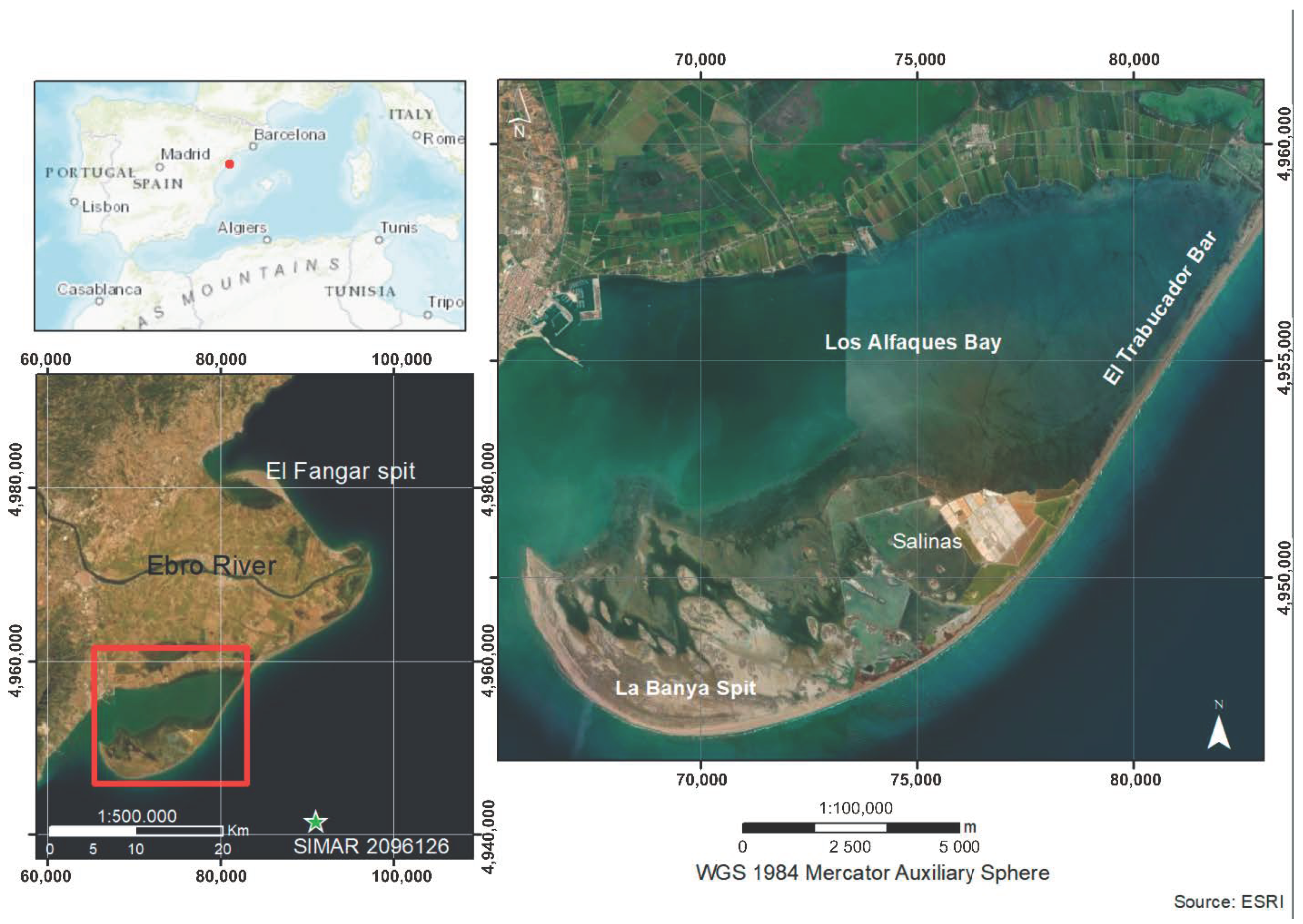
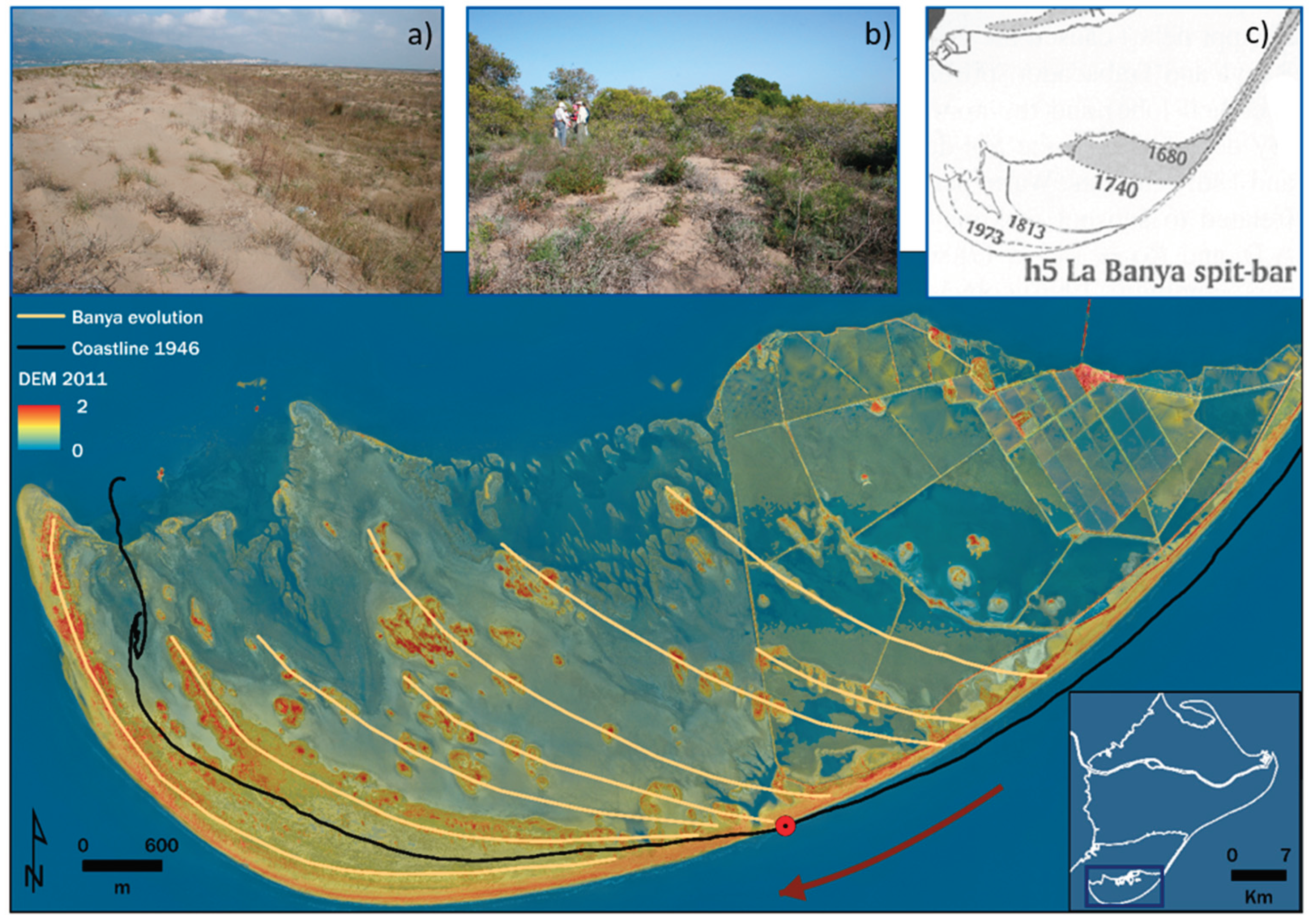
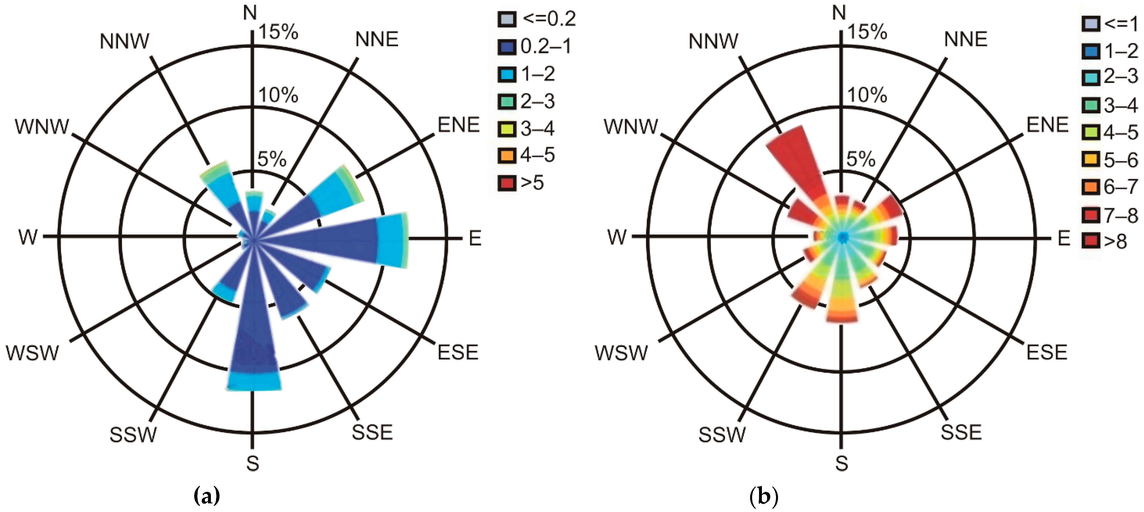
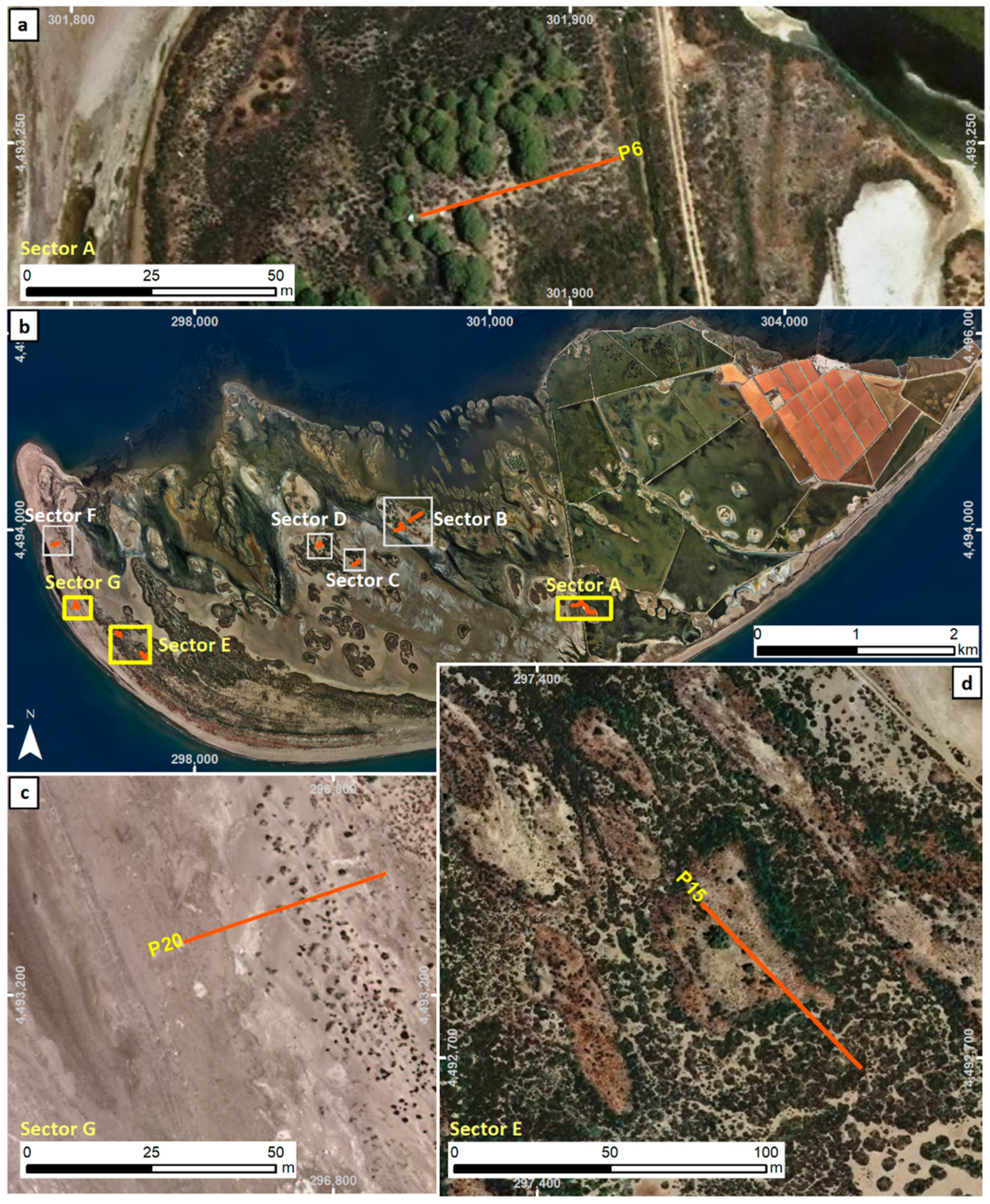
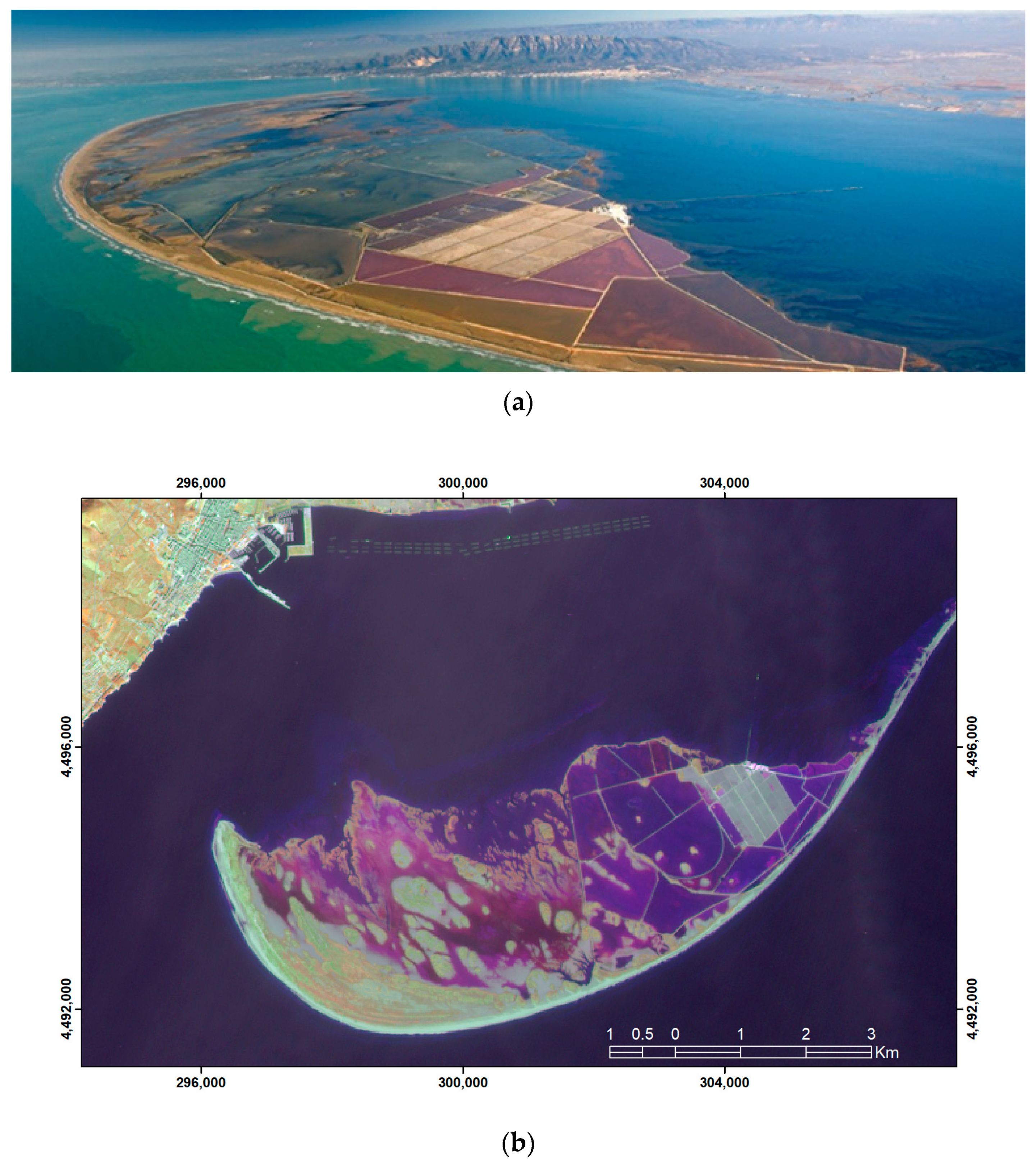
Study Area
2. Materials and Methods
2.1. LiDAR Topography of the Dunes
2.2. GPR Ground Penetrating Radar (GPR)
3. Results
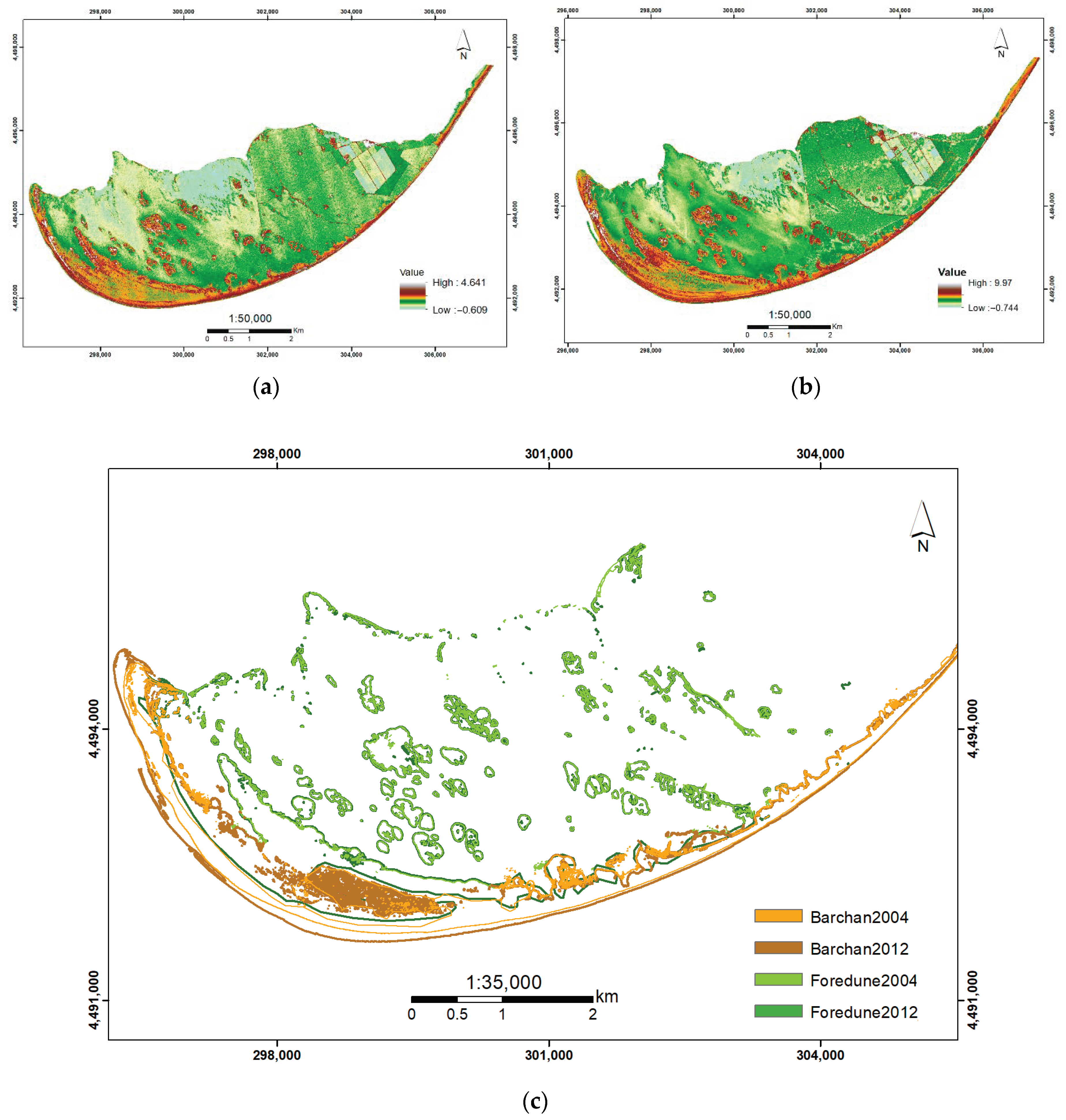
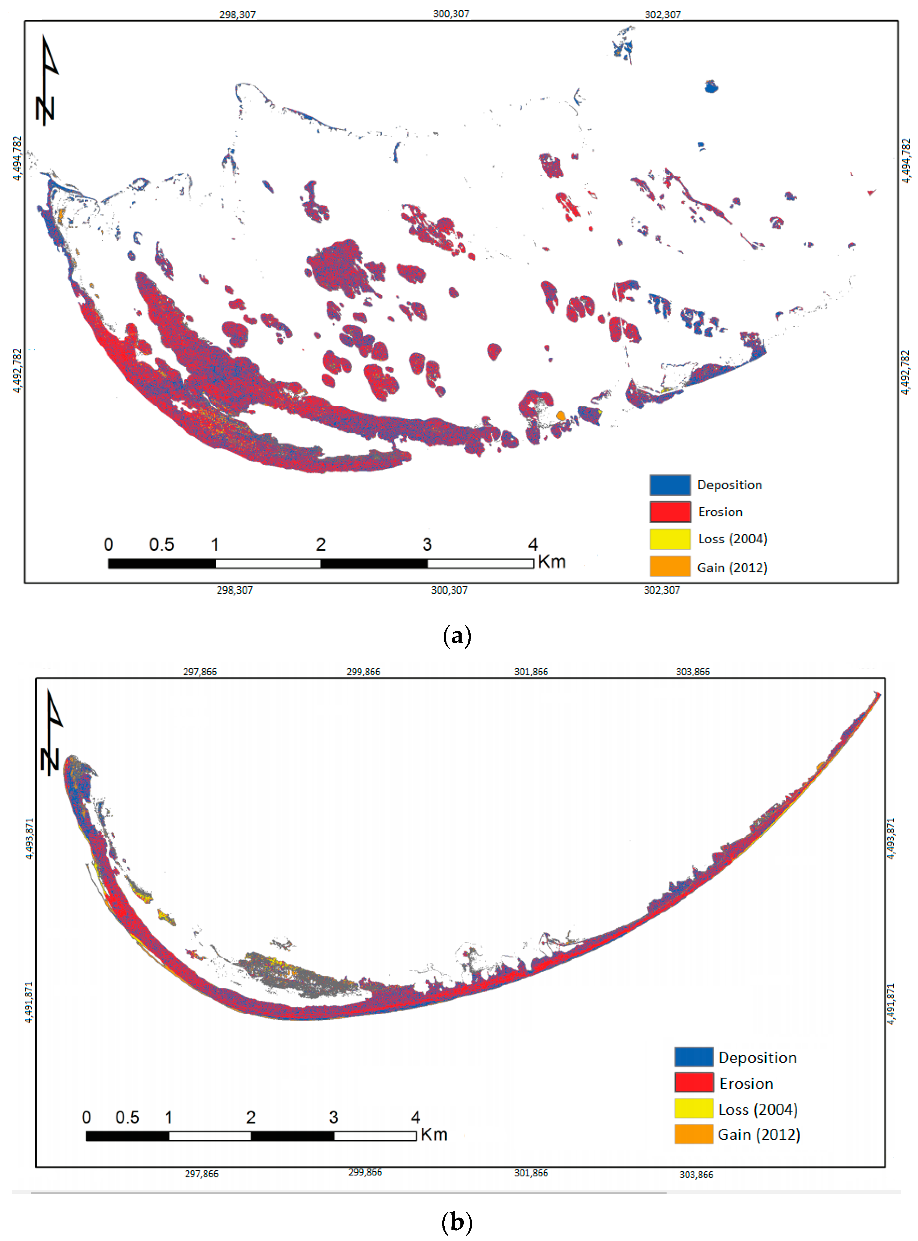
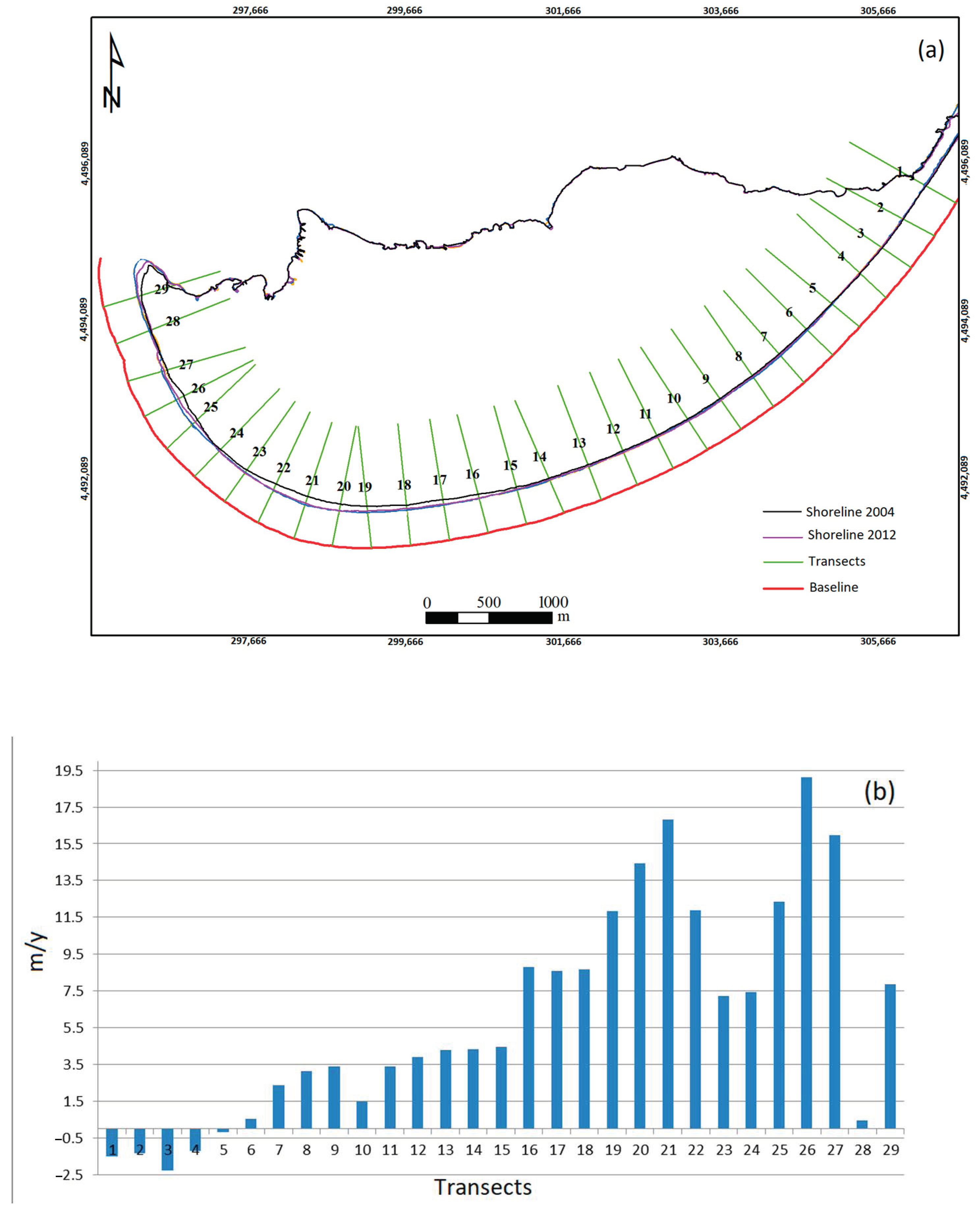
3.1. Analysis of Surfaces and Volumes
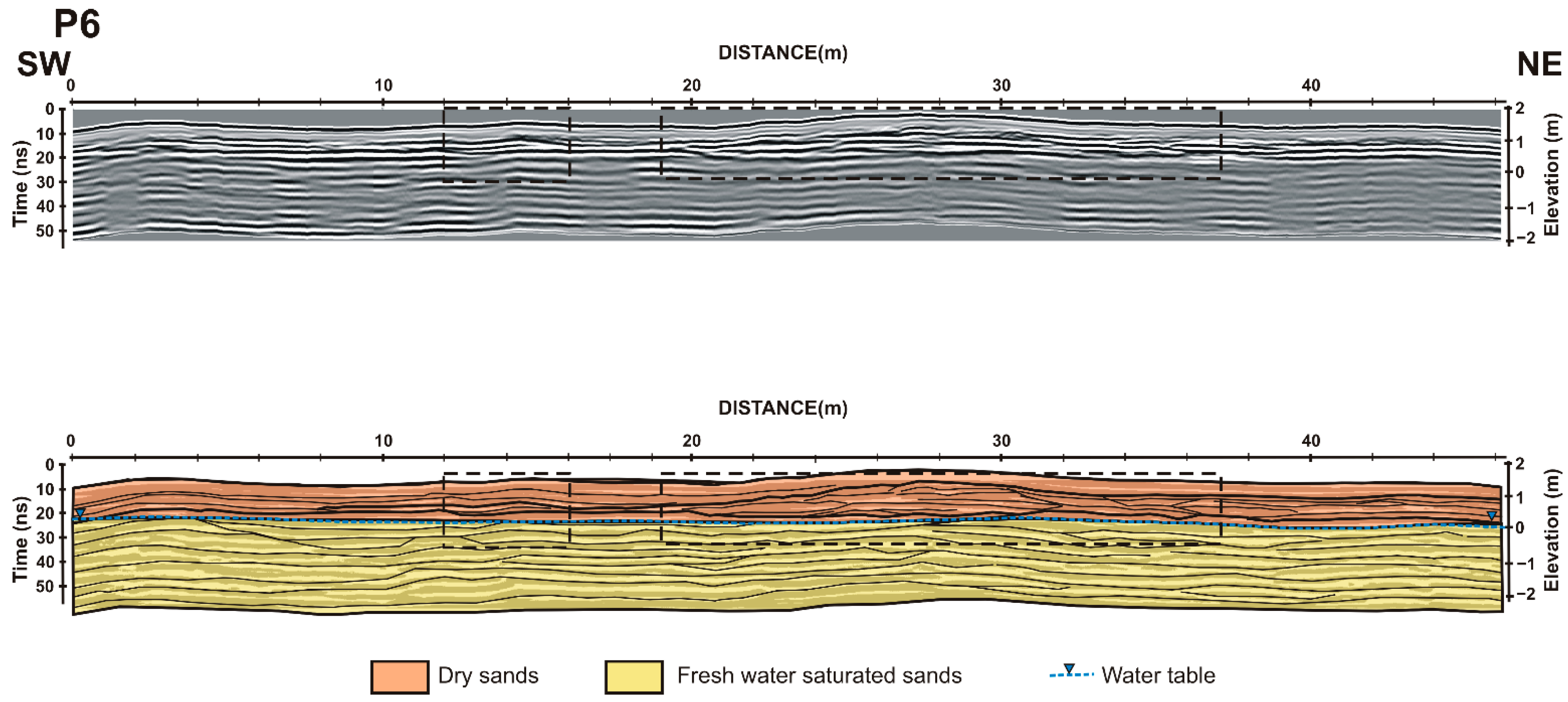
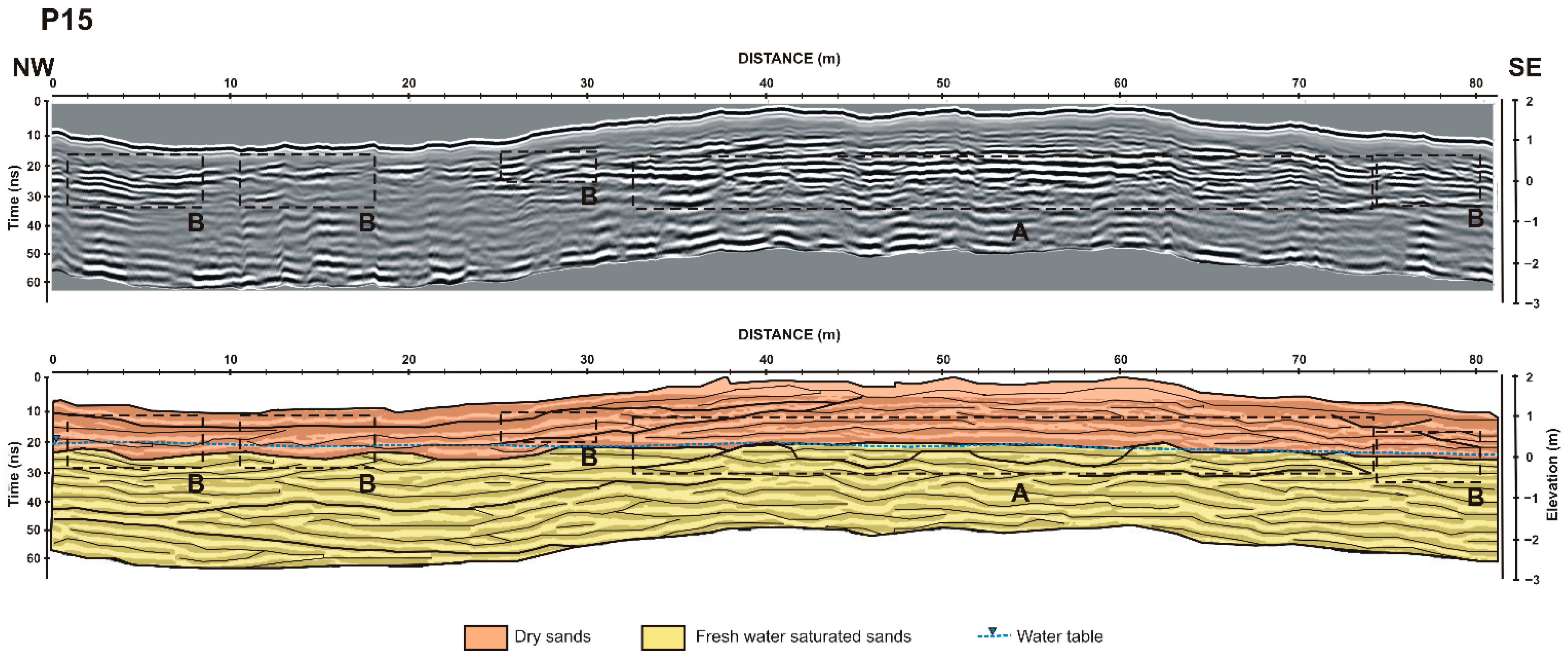
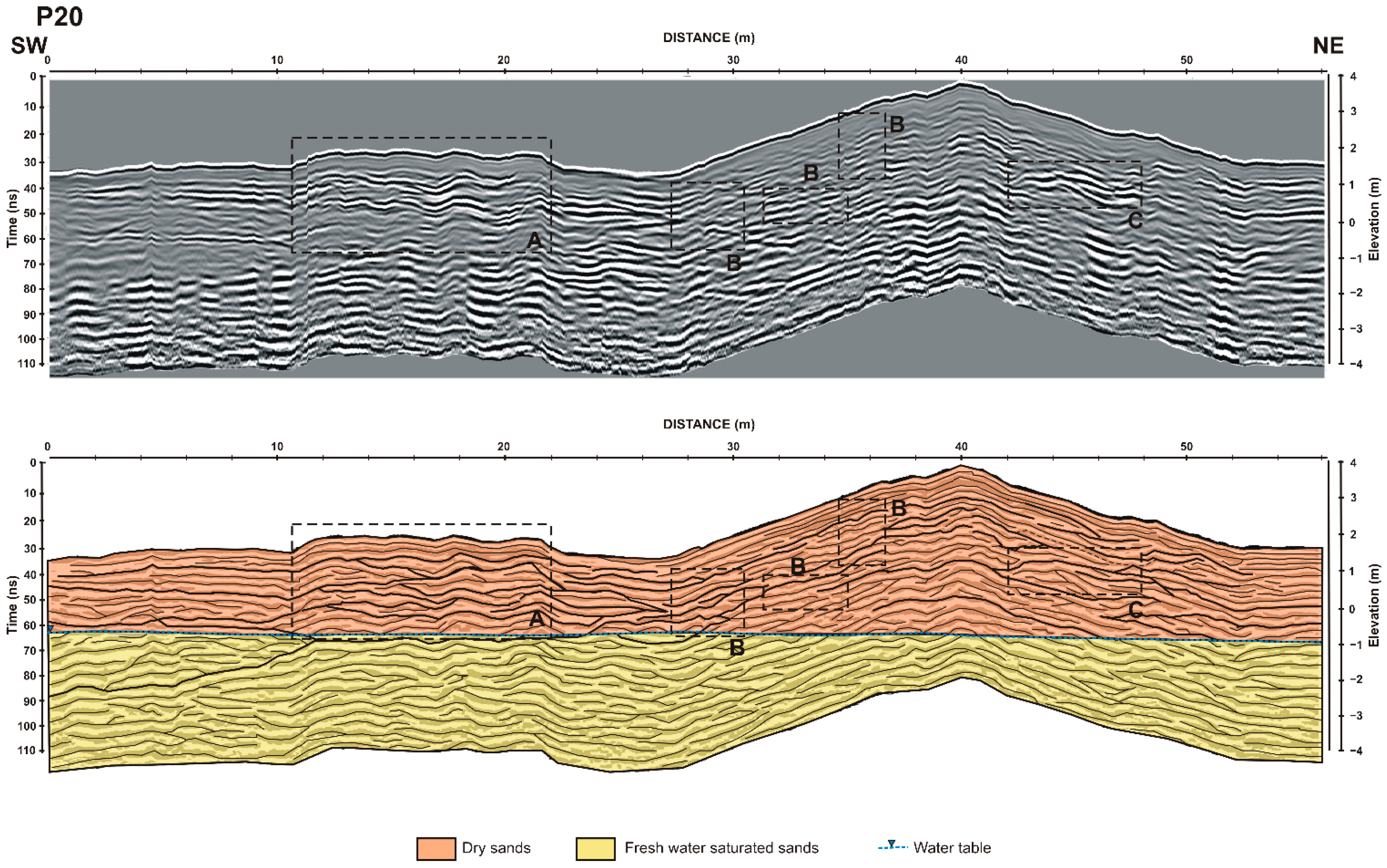
3.2. Analysis of GRP Profiles
4. Discussion and Conclusions
Author Contributions
Funding
Institutional Review Board Statement
Informed Consent Statement
Data Availability Statement
Acknowledgments
Conflicts of Interest
References
- Puijenbroek, M.E.B.; Limpens, J.; De Groot, A.V.; Riksen, M.J.P.M.; Gleichman, M.; Slim, P.A.; Van Dobben, H.F.; Berendse, F. Embryo dune development drivers: Beach morphology, Growing season precipitation, and storms. Earth Surf. Process. Landf. 2017, 42, 1–12. [Google Scholar] [CrossRef]
- Nolet, C.; Riksen, M. Accommodation space indicates dune development potential along an urbanized and frequently nourished coastline. Earth Surf. Dyn. 2019, 7, 129–145. [Google Scholar] [CrossRef] [Green Version]
- Bristow, C.S.; Pucillo, K. Quantifying rates of coastal progradation from sediment volume using GPR and OSL: The Holocene fill of Guichen Bay, south-east South Australia. Sedimentology 2006, 53, 769–788. [Google Scholar] [CrossRef]
- Otvos, E.G. Beach ridges–definitions and significance. Geomorphology 2000, 32, 83–108. [Google Scholar] [CrossRef]
- Bristow, C.S.; Chroston, P.N.; Bailey, S.D. The structure and development of foredunes on a locally prograding coast: Insights from ground-penetrating radar surveys, Norfolk, UK. Sedimentology 2000, 47, 923–944. [Google Scholar] [CrossRef]
- Hesp, P. Morphology, dynamics and internal stratification of some established foredunes in Southeast Australia. Sediment. Geol. 1988, 55, 17–41. [Google Scholar] [CrossRef]
- Hesp, P. Foredunes and blowouts: Initiation, geomorphology and dynamics. Geomorphology 2002, 48, 245–268. [Google Scholar] [CrossRef]
- Anthony, E.J.; Marriner, N.; Morhange, C. Human influence and the changing geomorphology of Mediterranean deltas and coasts over the last 6000 years: From progradation to destruction phase? Earth-Sci. Rev. 2014, 139, 336–361. [Google Scholar] [CrossRef]
- Wolters, M.L.; Kuenzer, C. Vulnerability assessment of coastal river deltas–categorization and review. J. Coast. Conserv. 2015, 19, 345–368. [Google Scholar] [CrossRef]
- Alvarado-Aguilar, D.; Jiménez, J.A.; Nicholls, R.J. Flood hazard and damage assessment in the Ebro Delta (NW Mediterranean) to relative sea level rise. Nat. Hazards 2012, 62, 1301–1321. [Google Scholar] [CrossRef]
- Gracia, F.J.; Del Río, L.; Alonso, C.; Benavente, J.; Anfuso, G. Historical evolution and present state of the coastal dune systems in the Atlantic coast of Cádiz (SW Spain): Palaeoclimatic and environmental implications. J. Coast. Res. 2006, S.I. 48, 55–63. [Google Scholar]
- Labuz, T.A. A review of field methods to survey coastal dunes–experience based on research from South Baltic coast. J. Coast. Conserv. 2016, 20, 175–190. [Google Scholar] [CrossRef] [Green Version]
- Rodríguez-Santalla, I.; Somoza, L. The Ebro River Delta. In The Spanish Coastal Systems–Dynamic Processes, Sediments and Management, 1st ed.; Morales, J.A., Ed.; Springer: Berlin/Heidelberg, Germany, 2019; Volume 1, pp. 467–488. [Google Scholar]
- Rodríguez Santalla, I.; Sánchez, M.J.; González, A.; Montoya, I. Topografía de dunas con GPS-D. In Las Dunas en España, 1st ed.; Sanjaume, E., Gracia, F.J., Eds.; Sociedad Española de Geomorfología: Cáceres, Spain, 2011; Volume 1, pp. 87–104. [Google Scholar]
- Pranzini, E. Airborne LiDAR survey applied to the analysis of the historical evolution of the Arno River delta (Italy). J. Coast. Res. 2007, S.I. 50, 400–409. [Google Scholar]
- Houser, C. Alongshore variation in the morphology of coastal dunes: Implications for storm response. Geomorphology 2013, 199, 48–61. [Google Scholar] [CrossRef]
- Woolard, J.W.; Colby, J.D. Spatial characterization, resolution, and volumetric change of coastal dunes using airborne LIDAR: Cape Hatteras, North Carolina. Geomorphology 2002, 48, 269–287. [Google Scholar] [CrossRef] [Green Version]
- Mitasova, H.; Overton, M.; Harmon, R.S. Geospatial analysis of a coastal sand dune field evolution: Jockey’s Ridge, North Carolina. Geomorphology 2005, 72, 204–221. [Google Scholar] [CrossRef]
- Saye, S.E.; Van der Wal, D.; Pye, K.; Blott, S.J. Beach-dune morphological relationships and erosion/accretion: An investigation at five sites in England and Wales using LIDAR data. Geomorphology 2006, 72, 128–155. [Google Scholar] [CrossRef]
- Vallejo, I.; Hernández Calvento, L.; Ojeda, J.; Máyer, P.; Gómez, M.A. Caracterización morfométrica y balance sedimentario en el sistema de dunas de Maspalomas (Gran Canaria) a partir de datos LiDAR. Rev. Soc. Geol. España 2009, 22, 57–65. [Google Scholar]
- Bazzichetto, M.; Malavasi, M.; Acosta, A.T.R.; Carranza, M.L. How does dune morphology shape coastal EC habitats occurrence? A remote sensing approach using airborne LiDAR on the Mediterranean coast. Ecol. Indic. 2016, 71, 618–626. [Google Scholar] [CrossRef]
- Conery, I.; Brodie, K.; Spore, N.; Walsh, J. Terrestrial LiDAR monitoring of coastal foredune evolution in managed and unmanaged systems Earth Surf. Process. Landform 2020, 45, 877–892. [Google Scholar] [CrossRef]
- Rodríguez Santalla, I.; Sánchez, M.J.; Montoya, I.; Gómez, D.; Martín, T.; Serra, J. Internal structure of the aeolian sand dunes of El Fangar spit, Ebro Delta (Tarragona, Spain). Geomorphology 2009, 104, 238–252. [Google Scholar] [CrossRef]
- Gómez-Ortiz, D.; Martín-Crespo, T.; Rodríguez, I.; Sánchez, M.J.; Montoya, I. The internal structure of modern barchan dunes of the Ebro River Delta (Spain) from ground penetrating radar. J. Appl. Geophys. 2009, 68, 159–170. [Google Scholar] [CrossRef]
- Alcántara-Carrió, J.; Fontán, A.; Sánchez, M.J.; Corbi, A. Métodos de campo y laboratorio para el estudio de procesos eólicos. In Las Dunas en España, 1st ed.; Sanjaume, E., Gracia, F.J., Eds.; Sociedad Española de Geomorfología: Madrid, Spain, 2011; Volume 1, pp. 67–86. [Google Scholar]
- Girardi, J.A. A GPR and Mapping Study of the Evolution of an Active Parabolic Dune Systema. Napeague, New York. Ph.D. Thesis, Department of Geosciences, Stony Brook University, Manhattan, NY, USA, 2005. [Google Scholar]
- Pires, A.; Chaminé, H.I.; Piqueiro, F.; Pérez-Alberti, A.; Rocha, F. Combining coastal geoscience mapping and photogrammetric surveying in maritime environments (Northwestern Iberian Peninsula): Focus on methodology. Environ. Earth Sci. 2016, 75, 196. [Google Scholar] [CrossRef]
- Davis, J.L.; Annan, A.P. Ground-penetrating radar for high-resolution mapping of soil and rock stratigraphy. Geophys. Prospect. 1989, 37, 531–551. [Google Scholar] [CrossRef]
- Telford, W.M.; Geldart, L.P.; Sheriff, R.E. Applied Geophysics; Cambridge University Press: Cambridge, UK, 1990; p. 770. [Google Scholar]
- Daniels, D.J. Surface-Penetrating Radar; The Institution of Electrical Engineers: London, UK, 1996. [Google Scholar]
- Reynolds, J.M. An Introduction to Applied and Environmental Geophysics; John Wiley: New York, NY, USA, 1997. [Google Scholar]
- Neal, A. Ground-penetrating radar and its use in sedimentology: Principles, problems and progress. Earth-Sci. Rev. 2004, 66, 261–330. [Google Scholar] [CrossRef]
- Pedersen, K.; Clemmensen, L.B. Unveiling past aeolian landscapes: A ground penetrating radar survey of a Holocene coastal dunefield system, Thy, Denmark. Sediment. Geol. 2005, 177, 57–86. [Google Scholar] [CrossRef]
- Bristow, C.S.; Lancaster, N.; Duller, G.A.T. Combining ground penetrating radar surveys and optical dating to determine dune migration in Namibia. J. Geol. Soc. Lond. 2005, 162, 315–321. [Google Scholar] [CrossRef]
- Costas, S.; Alejo, I.; Rial, F.; Lorenzo, H.; Nombela, M.A. Cyclical evolution of a modern transgressive sand barrier in Northwestern Spain elucidated by GPR and aerial photos. J. Sediment. Res. 2006, 76, 1077–1092. [Google Scholar] [CrossRef]
- Aagaard, T.; Oxford, J.; Murray, A.S. Environmental controls on coastal dune formation; Skallingen Spit, Denmark. Geomophology 2007, 83, 29–47. [Google Scholar] [CrossRef]
- Moura, M.V.M.; Reyes-Perez, Y.A.; Siqueira, D.; Santos, D.A.; Medeiros, A.; Reis, A.P.M.; Pinheiro, F. Levantamento geofísico com GPR em um campo de dunas eólicas em Tibau do Sul/RN. Rev. De Geol. 2006, 19, 99–108. [Google Scholar]
- Van Dam, R.L.; Nichol, S.L.; Augustinus, P.C.; Parnell, K.E.; Hosking, P.L.; McLean, R.F. GPR stratigraphy of a large active dune on Parengarenga Sandspit, New Zealand. Lead. Edge 2003, 22, 865–870. [Google Scholar] [CrossRef]
- Bristow, C.S. Ground penetrating radar in aeolian dune sands. In Ground Penetrating Radar: Theory and Applications; Elsevier: Amsterdam, The Netherlands, 2009; pp. 273–297. [Google Scholar]
- Havholm, K.G.; Ames, D.V.; Whittecar, G.R.; Wenell, B.A.; Riggs, S.R.; Jol, H.M.; Holmes, M.A. Stratigraphy of back-barrier coastal dunes, northern North Carolina and southern Virginia. J. Coast. Res. 2004, 20, 980–999. [Google Scholar] [CrossRef]
- Flor-Blanco, G.; Rubio-Melendi, D.; Flor, G.; Fernández-Álvarez, J.P.; Jackson, D.W.T. Holocene evolution of the Xagó dune field (Asturias, NW Spain) reconstructed by means of morphological mapping and ground penetrating radar surveys. Geo-Mar. Lett. 2016, 36, 35–50. [Google Scholar] [CrossRef]
- Forde, T.C.; Nedimović, M.R.; Gibling, M.R.; Forbes, D.L. Coastal Evolution Over the Past 3000 Years at Conrads Beach, Nova Scotia: The Influence of Local Sediment Supply on a Paraglacial Transgressive System. Estuaries Coasts 2016, 39, 363–384. [Google Scholar] [CrossRef] [Green Version]
- Rockett, G.C.; Barboza, E.G.; Rosa, M.L.C. Ground Penetrating Radar applied to the Characterization of the Itapeva Dunefield, Torres, Brazil. J. Coast. Res. 2016, 75, 323–327. [Google Scholar] [CrossRef]
- Somoza, L.; Barnolas, A.; Arasa, A.; Maestro, A.; Rees, J.G.; Hernandez-Molina, F.J. Architectural stacking patterns of the Ebro delta controlled by Holocene high-frequency eustatic fluctuations, delta-lobe switching and subsidence processes. Sediment. Geol. 1998, 117, 11–32. [Google Scholar]
- Sánchez-García, M.J.; Montoya-Montes, I.; Casamayor, M.; Alonso, I.; Rodríguez-Santalla, I. Coastal Dunes in the Ebro Delta. In The Spanish Coastal Systems-Dynamic Processes, Sediments and Management, 1st ed.; Morales, J.A., Ed.; Springer: Berlin/Heidelberg, Germany, 2019; pp. 611–630. [Google Scholar]
- Rodríguez-Santalla, I.; Gómez, D.; Sánchez, M.J.; Montoya-Montes, I.; Martín, T.; Martín-Velázquez, S.; Barrio, F.; Serra, J.; Gracia, F.J. Comparación de la dinámica dunar entre las formaciones situadas en los hemideltas norte y sur del río Ebro. Geo-Temas 2017, 17, 287–290. [Google Scholar]
- Serra, J.; Rodríguez, I.; Sánchez, M.J.; Montoya, I. Delta del Ebro: Papel del sistema dunar frente a la regresión deltaica (actuaciones y medidas paliativas). In La Gestión Integrada de Playas y Dunas: Experiencias en Latinoamérica y Europa, 1st ed.; Rodríguez-Perea, A., Pons, G.X., Roig-Munar, F.X., Martín-Prieto, J.A., Mir-Gual, M., Cabrera, J.A., Eds.; Monografies de la Societat d’Història Natural: Balears, Spain, 2012; Volume 19, pp. 365–373. [Google Scholar]
- Thieler, E.R.; Himmelstoss, E.A.; Zichichi, J.L.; Ergul, A. Digital Shoreline Analysis System (DSAS) version 4.0—An ArcGIS extension for calculating shoreline change. In U.S. Geological Survey Open-File Report, 2008-1278; U.S. Geological Survey: Reston, WV, USA, 2009. [Google Scholar]
- Oyedotun, T.D. Shoreline geometry: DSAS as a tool for Historical Trend Analysis. Br. Soc. Geomorphol. 2014, 3, 1–12. [Google Scholar]
- Guillen, J.; Diaz, J.I. Elementos morfológicos en la zona litoral: Ejemplos en el delta del Ebro. Sci. Mar. 1990, 54, 359–373. [Google Scholar]
- Rodríguez-Santalla, I.; Gracia, F.J.; Pérez-Morales, C.; Serra, J.; Medialdea, A.; Barrio, F. Análisis de los cambios geomorfológicos ocurridos en la flecha de los Alfaques (Delta del Ebro, Tarragona). Geo-Temas 2015, 15, 73–76. [Google Scholar]
- Jiménez, J.A.; Sancho-García, A.; Bosom, E.; Valdemoro, H.; Guillén, J. Storm-induced damages along the Catalan coast (NW Mediterranean) during the period 1958–2008. Geomorphology 2012, 143–144, 24–33. [Google Scholar]


| Barchan | ||||
| Year | Surface (m2) | Volume (m3) | Average height (m) | Maximum height (m) |
| 2004 | 1,882,960.01 | 673,013.54 | 0.748 | 3.457 |
| 2012 | 2,217,239.22 | 803,860.07 | 0.75 | 3.998 |
| Foredune | ||||
| Year | Surface (m2) | Volume (m3) | Average height (m) | Maximum height (m) |
| 2004 | 3,224,915.64 | 1,079,221.13 | 0.726 | 3.330 |
| 2012 | 3,201,031.75 | 1,045,013.87 | 0.716 | 3.404 |
Publisher’s Note: MDPI stays neutral with regard to jurisdictional claims in published maps and institutional affiliations. |
© 2021 by the authors. Licensee MDPI, Basel, Switzerland. This article is an open access article distributed under the terms and conditions of the Creative Commons Attribution (CC BY) license (http://creativecommons.org/licenses/by/4.0/).
Share and Cite
Rodríguez-Santalla, I.; Gomez-Ortiz, D.; Martín-Crespo, T.; Sánchez-García, M.J.; Montoya-Montes, I.; Martín-Velázquez, S.; Barrio, F.; Serra, J.; Ramírez-Cuesta, J.M.; Gracia, F.J. Study and Evolution of the Dune Field of La Banya Spit in Ebro Delta (Spain) Using LiDAR Data and GPR. Remote Sens. 2021, 13, 802. https://0-doi-org.brum.beds.ac.uk/10.3390/rs13040802
Rodríguez-Santalla I, Gomez-Ortiz D, Martín-Crespo T, Sánchez-García MJ, Montoya-Montes I, Martín-Velázquez S, Barrio F, Serra J, Ramírez-Cuesta JM, Gracia FJ. Study and Evolution of the Dune Field of La Banya Spit in Ebro Delta (Spain) Using LiDAR Data and GPR. Remote Sensing. 2021; 13(4):802. https://0-doi-org.brum.beds.ac.uk/10.3390/rs13040802
Chicago/Turabian StyleRodríguez-Santalla, Inmaculada, David Gomez-Ortiz, Tomás Martín-Crespo, María José Sánchez-García, Isabel Montoya-Montes, Silvia Martín-Velázquez, Fernando Barrio, Jordi Serra, Juan Miguel Ramírez-Cuesta, and Francisco Javier Gracia. 2021. "Study and Evolution of the Dune Field of La Banya Spit in Ebro Delta (Spain) Using LiDAR Data and GPR" Remote Sensing 13, no. 4: 802. https://0-doi-org.brum.beds.ac.uk/10.3390/rs13040802