1. Introduction
Lecce Cathedral is located in the center of the city (
Figure 1), on the southeastern corner of a square where other edifices are built, including the bell tower, the bishop’s residence, and the seminary [
1,
2,
3]. The cathedral, dedicated to the Assumption of the Virgin Mary, was first built in 1144 by bishop Formoso (dates of birth and death unknown). In 1230, it was rebuilt in the Romanesque style during the bishopric of Voltorico (born before 1214—died after 1252). After the demolition of the previous building in 1658, it was rebuilt once again in the Baroque style in 1659 by the architect Giuseppe Zimbalo (1620–1710) and by order of bishop Luigi Pappacoda (1639–1670). It was completed in 1670 and it has not gone undergone relevant changes to the present day.
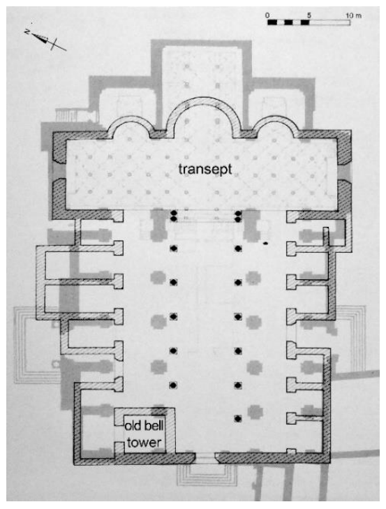
In the 13th century, the church had a Latin cross plan with three naves divided by columns (
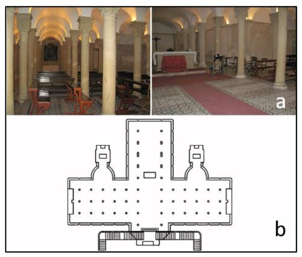
Figure 2); three apses were at the end wall of the transept, while chapels were along the external naves. A bell tower was in the southwestern corner of the building, close to the façade. A 12th-century crypt was under the transept; transformed in the 16th century, it has an elongated rectangular shape and it is divided into three naves characterized by 54 columns and 38 semicolumns (
Figure 3). In the 17th century, but before 1670, the church preserved the Latin cross plan with three naves, which were divided by pilasters and enlarged. The apses were extended and transformed into quadrangular-shaped spaces: a choir was built in the central space, behind the altar, while two chapels dedicated to Saint Orontius and the Assumption of Mary were in external spaces. Baroque modifications also involved the crypt, where some altars were built in this period.
A new bell tower was built by Zimbalo in 1661–1682: it was separated from the church and located northwest of the transept.
GPR surveys were performed in Lecce Cathedral before the restoration works performed in the crypt located under the transept. These investigations are part of a research project started in 2013 with the aim to study the transformations of Lecce from the Messapian era to the Medieval period and the drawing of an archaeological map of the city. In particular, the GPR surveys inside the 17th-century cathedral were aimed at collecting data about the presence of unknown structures, chambers, and tombs under the floors of the church and the crypt. The international literature is full of case studies related to the successful application of geophysical methods to archeology. Some studies are related to the need to evaluate the effectiveness of the georadar method according to the depth of investigation and the consequent ability to reconstruct the archaeological stratigraphy in sites with complex geology [
4]. Other geophysical methods such as microgravimetry and seismic were evaluated successfully by several authors [
5,
6,
7,
8,
9,
10,
11,
12]. The magnetic method is one of the most used in archaeological applications [
13,
14,
15,
16,
17,
18]. In cases in which it is important to highlight structures linked to the presence of cavities or structures placed inside highly conductive media (i.e., with high electrical conductivity) the electrical resistivity tomography (ERT) method can provide good results [
11,
19,
20,
21]. All these methods clearly have limits also linked to the characteristics of the site to be prospected [
21]. In this case study, the site is located within an urban context, and this makes it difficult to use the microgravimetric and seismic methods due to the strong noise associated with urban traffic. The presence of buried structures such as electrical networks and water pipes makes the magnetic method not applicable. Inside the church, the presence of a marble floor makes the ERT method unusable due to the high resistivity contact. Therefore, GPR was used. This method applied in this contest allows us to evidence the presence of buried structures. The shapes and the sizes suggest that they are related to the presence of unknown buried rooms. Most of them are interpreted as tombs.
2. Materials and Methods
The GPR surveys were performed at different times. The first survey was undertaken in the crypt in 2009 before the restructuration works. Here, the georadar system Sir 3000 (by GSSI) with a 270 MHz antenna was used.
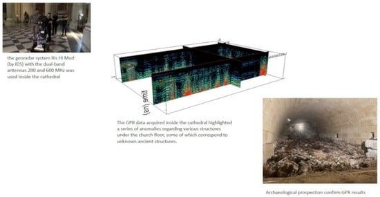
The second survey was undertaken in 2018 in the church after the restoration works. Here, the georadar system Ris Hi Mod (by IDS) with the dual-band antennas 200 and 600 MHz was used.
In both surveys, the GPR data acquisition were performed along contiguous parallel and orthogonal profiles 0.25 m wide, 512 samples per trace. The data were processed using the Gpr-slice Version 7.0 software [
22]. The following processing steps were used:
- (i)
background removal filter: the filter provides for the arithmetic sum of all the tracks and the subsequent division by the number of tracks. The result is an average trace that is subsequently subtracted from the entire radar section. It is thus possible to eliminate background noise;
- (ii)
Kirchhoff migration [
23]: once the propagation velocity of the electromagnetic waves in the medium is known, migration is an operation that allows the diffraction hyperbolas to collapse at their apex, allowing objects to be given their own shapes;
- (iii)
gain manually function: this allows emphasizing the display of low-amplitude reflected events of the electromagnetic wave.
The electromagnetic wave velocity played an important role in order to both perform the migration and convert the two-way time window into depth. It was evaluated by the hyperbola fitting method [
21], resulting in an average velocity of 0.1 m/ns.
The way of acquiring the radar profiles (parallel profiles at a distance of 0.25 m) made it possible to create maps (horizontal time slices) within which it was possible to view the spatial distribution of the amplitudes of the reflected events.
These are maps in which reflected events of the same electromagnetic amplitude are correlated within specific time intervals [
24]. Furthermore, the overlay analysis method [
25] was used. This method allows us to evidence better the weakest reflector related to deeper features that are indistinguishable on radargrams.
In the present work, the time-slice technique has been built using time windows Δt = 10 ns for the profiles acquired in the crypt and Δt = 5 ns for the profiles acquired in the cathedral. Another way to visualize the spatial position of the amplitude anomalies is the three-dimensional amplitude isosurface [
26,
27,
28,
29,
30]. In this way, it is possible to display amplitudes of equal value in the GPR study volume. The shading function allows for the apparent or real shape of the buried archaeological structure. In this case, the threshold calibration is a very delicate task in order to obtain useful results [
21].
3. Results
3.1. The Crypt
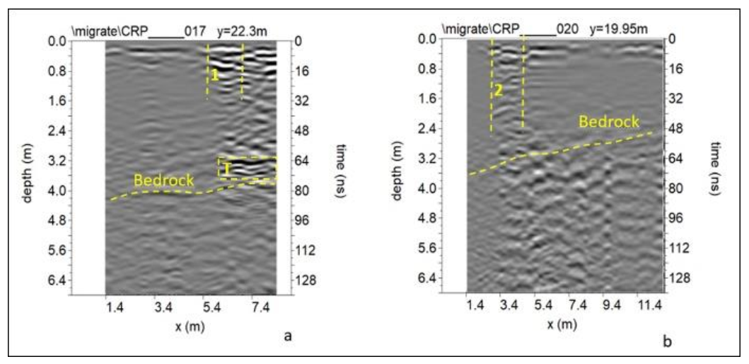
The GPR data acquired in the crypt show good electromagnetic (EM) signal propagation (about 6 m if considering an EM wave velocity of propagation of 0.1 m/ns). Variable reflection events are visible. In some of them, vertical fill layers are distinguished, which are probably related to the surface tombs (1 and 2 in
Figure 4a,b).
These wave reflections can be due to the material placed into tombs after burial. Additionally, there are extensive reflection events slightly undulating at a depth ranging from about 2.4 m to 4.0 m, which are probably due to the bedrock (yellow dashed line in
Figure 4a,b).
The point-source and confused reflections present in some areas on the radar sections may be related to the filling material.
In
Figure 4a, a distinctive pattern of very high amplitude reflection feature is visible at depths of about 3.0 m. This reflection event shows an inversion of the polarity that can be related to the probable presence of empty space [
21,
31,
31,
32]. The shape (linear) and the horizontal dimensions (about 2.0 m) suggest the presence of the top of an unknown tomb.
Considering the time window of width Δt = 10 ns and an electromagnetic wave velocity of 0.11 m/ns, the thickness of the slices was 0.5 m.
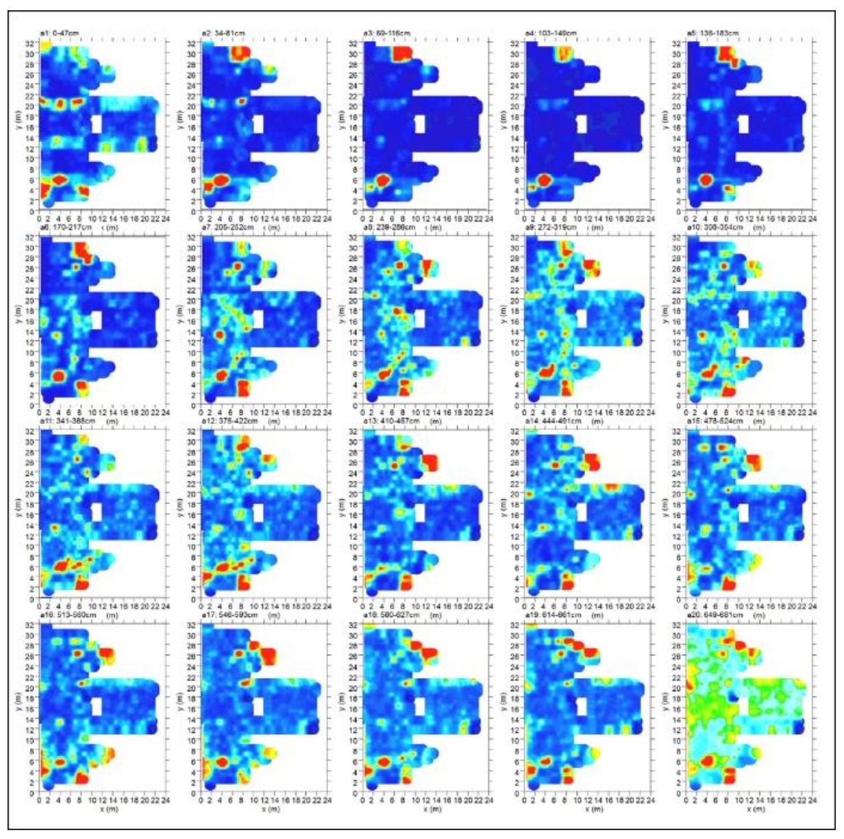
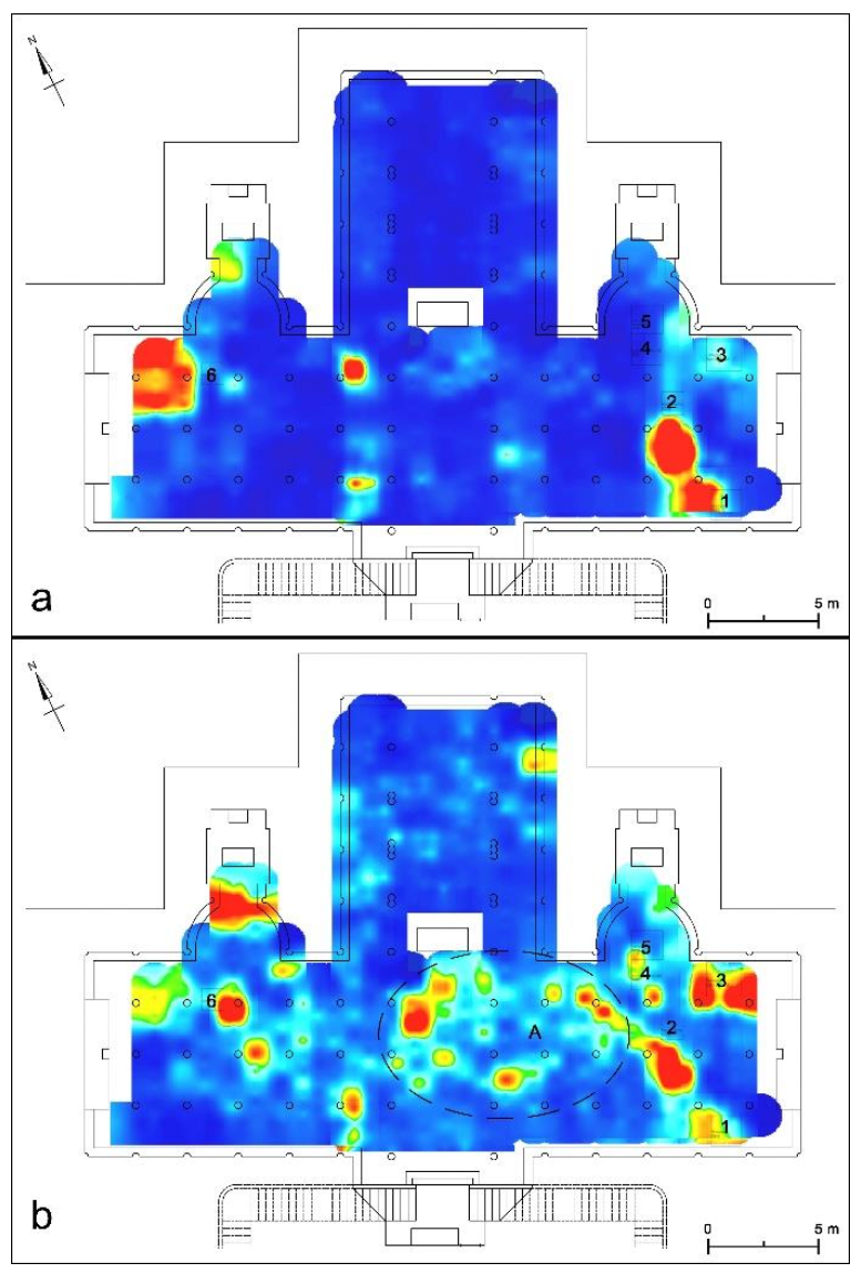
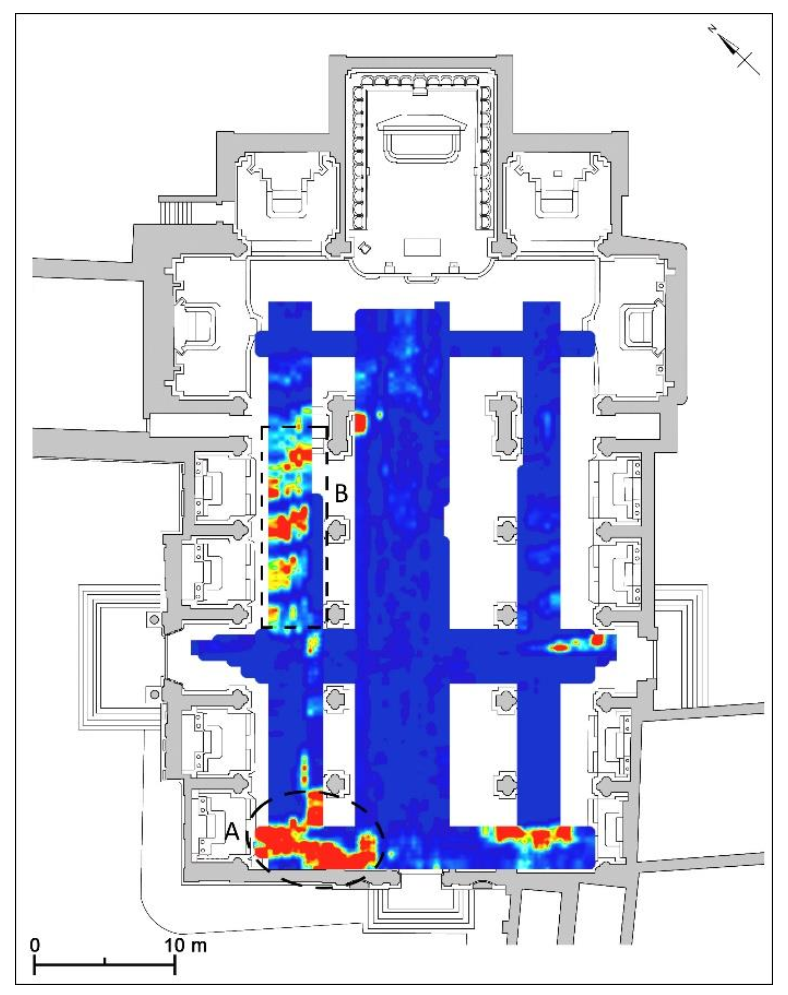
Figure 5 shows the more significant time slices inside the crypt. They highlighted other anomalies regarding underground tombs and structures, integrating the results of previous research [
33]. In particular, at some centimeters depth, immediately under the floor (
Figure 6a) are visible the anomalies regarding the tombs of the Bernardini Family (undated), Michael Mincuzzi (dated 1988), and Martirano (dated 1858), in the southern nave (
Figure 6a, nos. 1–3), and of an unknown person or family in the northern nave (
Figure 6b, no. 6); their presence is suggested by the tombstones that are in the floor of the crypt, above or near the tombs. Only at greater depths, over two meters, anomalies probably linked to the tombs of Marasco-Specchia (dated 1838) and Raffaele Perulli (dated 1858) are visible in the southern apse (
Figure 6b, nos. 4 and 5). Moreover, other anomalies probably linked to buried ancient structures are visible at a depth of about 2.5 m (
Figure 6b, A).
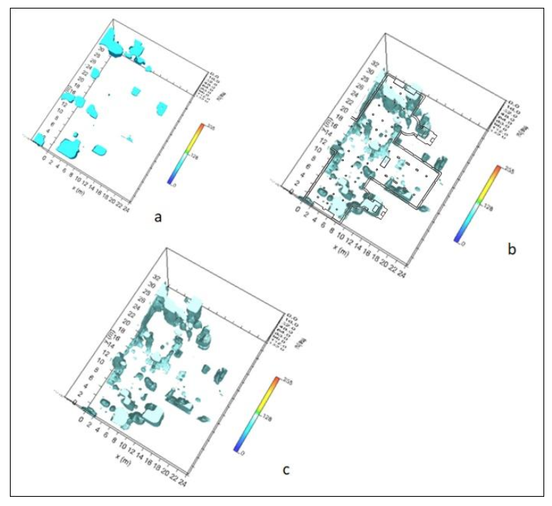
Figure 7 show the 3D isosurfaces related to three depth range: (i) 0.0–1.0 m (
Figure 7a), (ii) 1.5–3.0 m (
Figure 7b), and (iii) 3.0–4.0 m (
Figure 7c). They highlighted the 3D distribution of the anomalies regarding underground tombs and structures.
3.2. The Cathedral
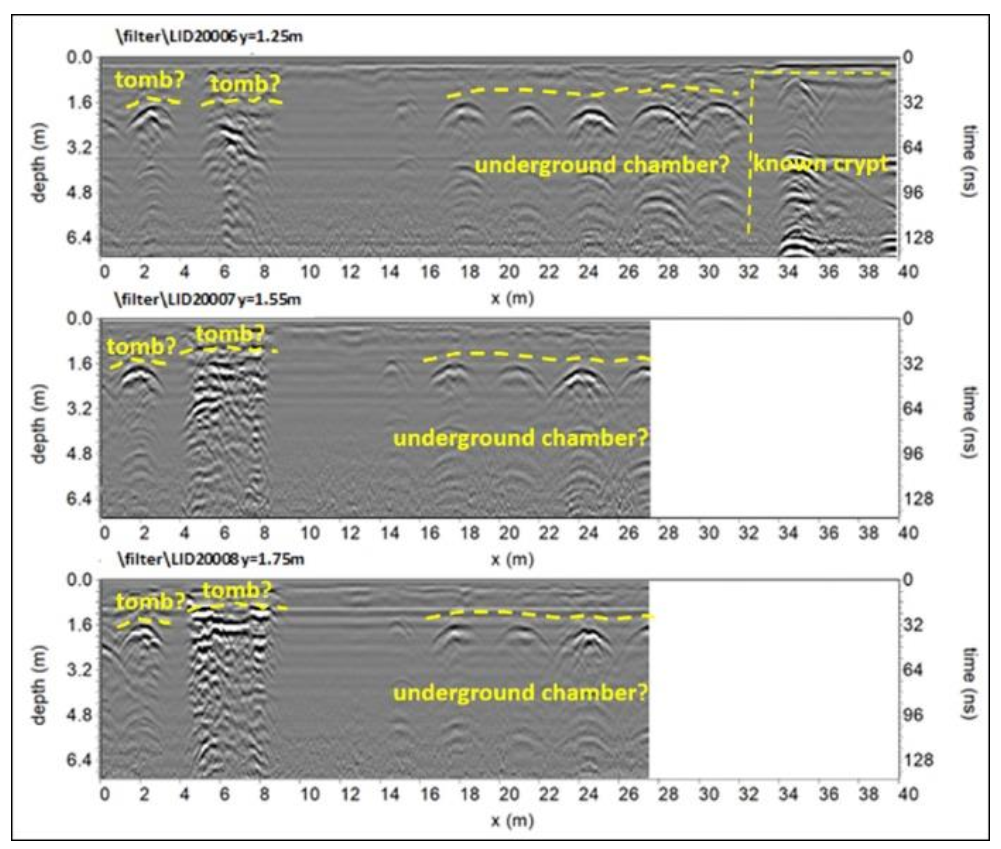
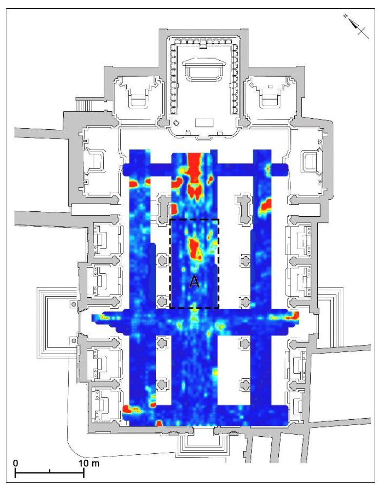
The GPR data acquired inside the cathedral highlighted a series of anomalies regarding various structures under the church floor, some of which correspond to the already known crypt under the transept and to other unknown ancient structures.
An interesting anomaly is visible at the central nave (indicated with “underground chamber?” in
Figure 8), which is attributed to an underground chamber (
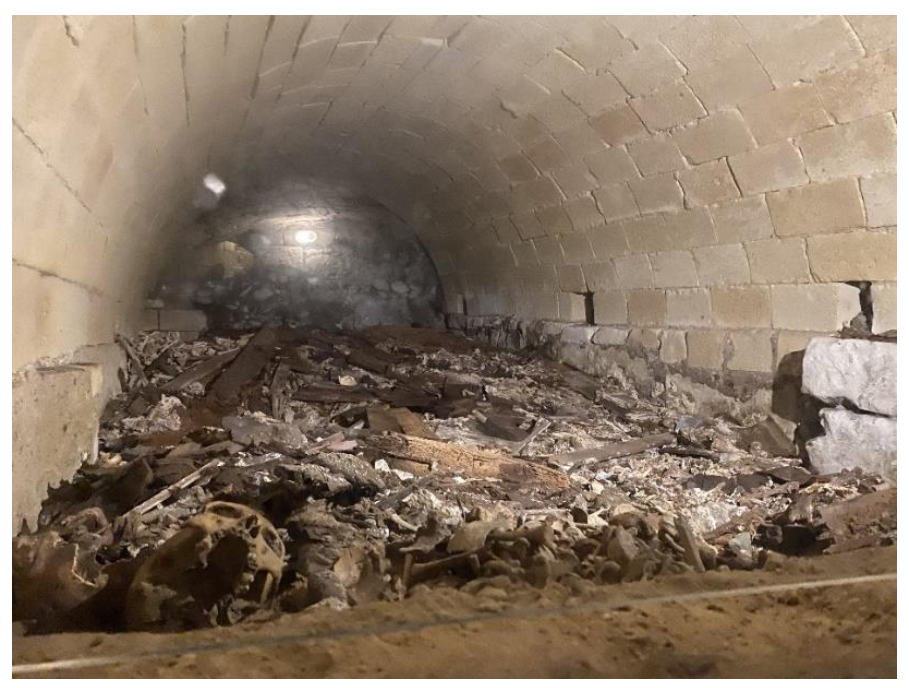
Figure 8) that is located at a depth between 1.42 m and 1.92 m. This chamber, accessible from the crypt under the transept, was prospected by archaeologists after the geophysical surveys conducted in 2009: inside them, numerous human bones have been found, suggesting also the presence of a putridarium (
Figure 9).
Here, the bodies of monks and nuns were placed in wall niches, often seated on masonry chairs with a central hole and container to collect the decomposition liquids. It was therefore a temporary burial place; once the bodies have reached a proper stage of decomposition, the bones are collected, cleaned, and stored in an ossuary. The remains of the structures can be generically dated to the late Middle Ages, pending the publication of the findings by the archaeologists. Successively, the archaeologists prospected the anomaly area indicated with “underground chamber?” in
Figure 8 and
Figure 10. Some chambers were found (
Figure 11).
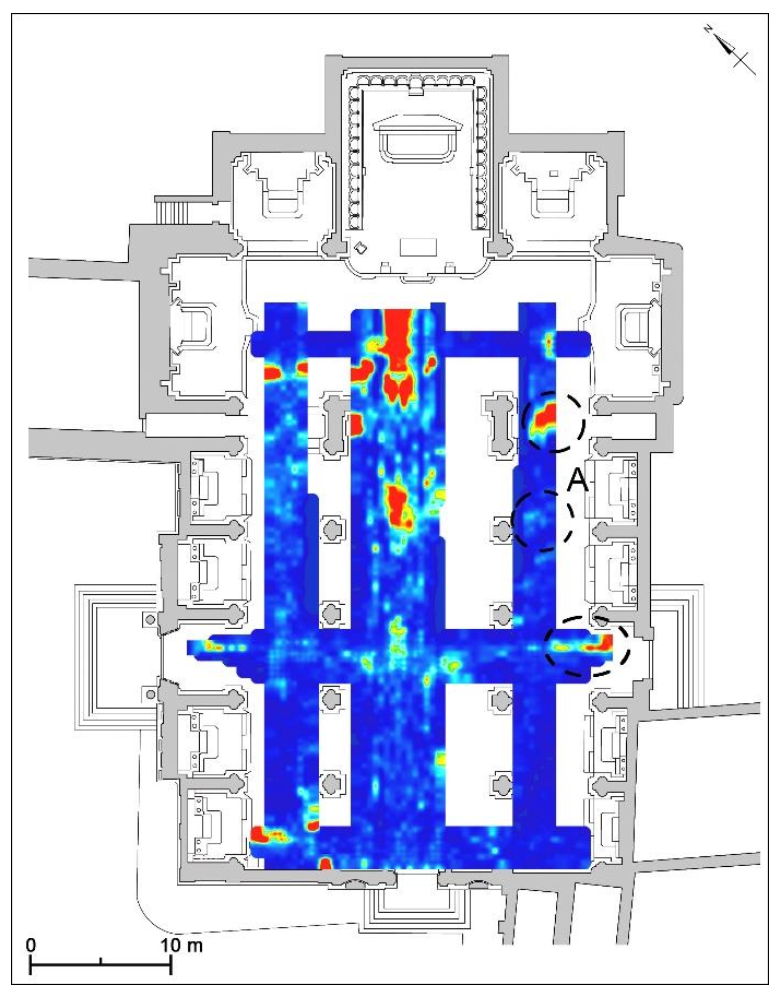
Other possible underground chambers, which could also reuse the masonries of the previous Romanesque church that survived demolitions are located below the southern and the northern nave (
Figure 8,
Figure 10, and
Figure 12). In particular, at the central sector of the southern nave, there are anomalies (
Figure 13, A) located more superficially than those measured in the northern nave. In the latter, in fact, the anomalies are clearly visible starting from a depth of 4.59 m: one of these is located at the western end of the nave where the bell tower of the previous church was constructed (
Figure 14, A); another group of anomalies adjacent to each other and similar in the shape and orientation are in the central sector of the northern nave and probably concerning underground chambers (
Figure 14, B).
The pseudo-3D visualization shows the distribution of the unknown structures below the cathedral (
Figure 15).
4. Conclusions
GPR surveys in the Baroque Cathedral of Lecce highlighted the presence of many anomalies relating to unknown structures under the floor of the church. Some of them could belong to the previous building of the Romanesque period, such as the buried structures of the bell tower and clearly visible starting from a depth of 4.59 m at the western end of the northern nave. Most of the anomalies are related to underground chambers such as those located below the southern and the northern nave, which could also reuse the masonries of the previous church. Another very interesting underground chamber was detected below the central nave at a depth between 1.42 m and 1.92 m; later, the archaeologists have prospected it and have highlighted their ossuaries’ function, thus suggesting the presence of a putridarium. Moreover, the presence of some tombs of the 19th and 20th centuries at some centimeters depth under the crypt floor was detected by GPR investigations. Their presence was suggested by anomalies relating to the tombstones that are in the floor of the crypt, above or near the tombs. They have been identified with the tombs of the Bernardini Family, Michael Mincuzzi, Martirano, and of an unknown person or family, and at greater depths, the tombs of Marasco-Specchia and Raffaele Perulli. Some anomalies probably linked to ancient buried structures were also highlighted at a depth of about 2.5 m. The geophysical surveys contributed to enriching the knowledge of the buried sectors of the monument since they highlighted the presence of anomalies relating to burial chambers; the archaeologists benefited from the precise location of some of these buried structures because they have been able to carry out focused and circumscribed excavations inside the church. The archaeological excavations were conducted following the results of the geophysical surveys carried out in 2009. Specifically, during the restoration work conducted in the crypt completed in 2017, the archaeologists chose to verify the geophysical anomalies located under the central nave in the sector accessible from the back wall of the crypt. The anomalies detected in other sectors of the church were not yet prospected. Therefore, the results of the geophysical prospections presented here enrich the knowledge also of the underground inaccessible parts of the Cathedral of Lecce, suggesting the presence of ancient structures in the invisible areas of the building and related to its previous phases. Moreover, they allowed recovering previously unknown data and also recovering the memory related to the presence of tombs of people and illustrious families in the crypt.
Author Contributions
Visualization: I.D., I.M., G.S.; methodology, investigations, analysis: L.D.G. and G.L.; data curation, validation: L.D.G., G.L., I.M., and G.S. All authors have read and agreed to the published version of the manuscript.
Funding
This research received no external funding.
Data Availability Statement
The data presented in this study are available on request from the corresponding author.
Acknowledgments
The authors thank the Bishopric of Lecce for the authorization to carry out the geophysical investigations inside the cathedral and in its crypt.
Conflicts of Interest
The authors declare no conflict of interest.
References
- Paone, M. Chiese di Lecce; Congedo Editore: Galatina, Italy, 1981; pp. 35–120, 275–285. [Google Scholar]
- Fagiolo, M.; Cazzato, V. Lecce; Editori Laterza: Roma-Bari, Italy, 1984; pp. 26–30, 92–94. [Google Scholar]
- Cazzato, V.; Fagiolo, M. Lecce. Architettura e Storia Urbana; Congedo Editore: Galatina, Italy, 2013; pp. 44–49, 167–171. [Google Scholar]
- Carrozzo, M.T.; Leucci, G.; Negri, S.; Nuzzo, L. GPR Survey to Understand the Stratigraphy of the Roman Ships Archaeological Site (Pisa, Italy). Archaeol. Prospect. 2003, 10, 57–72. [Google Scholar] [CrossRef]
- Butler, D.K. Microgravimetric and gravity gradient techniques for detection of subsurface cavities. Geophysics 1984, 49, 1084–1096. [Google Scholar] [CrossRef]
- Cuss, R.J.; Styles, P. The application of microgravity in industrial archaeology: An example from the Williamson tunnels, Edge Hill, Liverpool. Geoarchaeol. Explor. Environ. Resour. Geol. Soc. Lond. Spec. Publ. 1999, 165, 41–59. [Google Scholar] [CrossRef]
- Pasteka, R.; Terray, M.; Hajach, M.; Pasiakova, M. Microgravity measurements and GPR technique in the search for medieval crypts: A case study from the St. Nicholas church in Trnava, SW Slovakia. In Proceedings of the Archaeological Prospection 7th Conference, Vienna, Austria, 29 May–2 June 2013; Volume 41, pp. 222–224. [Google Scholar]
- Panisova, M.; Pasteka, R. The use of microgravity technique in archaeology: A case study from the St. Nicolas Church in Pukanec, Slovakia. Contrib. Geophys. Geod. 2009, 39, 237–254. [Google Scholar] [CrossRef] [Green Version]
- Pasteka, R.; Kusnirak, D.; Wilken, D.; Putiska, R.; Papco, J.; Godova, D.; Zvara, I.; Nogova, N.; Ondrasova, L. Effective combination of microgravimetry and geoelectrical methods in the detection of subsurface cavities in archaeological prospection—Selected case-studies from Slovakia. Contrib. Geophys. Geod. 2019, 49, 479–496. [Google Scholar] [CrossRef] [Green Version]
- Woelz, S.; Rabbel, W. Seismic prospecting in archaeology: A 3D shear-wave study of the ancient harbour of Miletus (Turkey). Near Surf. Geophys. 2005, 3, 245–257. [Google Scholar] [CrossRef]
- Leucci, G.; Greco, F.; De Giorgi, L.; Mauceri, R. 3D seismic refraction tomography and electrical resistivity tomography survey in the castle of occhiolà (sicily, italy). J. Archaeol. Sci. 2007, 34, 233–242. [Google Scholar] [CrossRef]
- Forte, E.; Pipan, M. Integrated seismic tomography and ground-penetrating radar (GPR) for the highresolution study of burial mounds (tumuli). J. Archaeol. Sci. 2008, 35, 2614–2623. [Google Scholar] [CrossRef]
- Ciminale, M.; Loddo, M. Aspects of magnetic data processing. Archaeol. Prospect. 2001, 8, 239–246. [Google Scholar] [CrossRef]
- Hudler, D.; Jarvis, J.; Griffith, T. A Partial Magnetometer Survey of The Archaeological Conservancy’s Portion of the A. C. Saunders Site (41AN19). J. Northeast Tex. Archaeol. 2018, 2018, 13. [Google Scholar] [CrossRef]
- Crew, P. Magnetic mapping and dating of prehistoric and medieval iron-working sites in northwest Wales. Archaeol. Prospect. 2002, 9, 163–182. [Google Scholar] [CrossRef]
- Linford, N.T. Magnetic ghosts: Mineral magnetic measurements on Roman and Anglo-Saxon graves. Archaeol. Prospect. 2004, 11, 167–180. [Google Scholar] [CrossRef]
- Di Giacomo, G.; De Giorgi, L.; Ditaranto, I.; Leucci, G.; Miccoli, I.; Scardozzi, G. The Medieval cave village of Casalrotto (Mottola, Apulia): New data on the settlement and its necropolis from archaeological and geophysical measurements. Measurement 2018, 128, 96–103. [Google Scholar] [CrossRef]
- Leucci, G. Advances in Geophysical Methods Applied to Forensic Investigations: New Developments in Acquisition and Data Analysis Methodologies; Springer Nature Switzerland AG: Cham, Switzerland, 2020; p. 200. ISBN 978-3-030-46241-3. [Google Scholar]
- Senos Matias, M.J. Electrical methods in archaeological exploration. Boll. Di Geofis. Teor. Ed. Appl. 2003, 44, 193–207. [Google Scholar]
- Leucci, G. Contribution of ground penetrating radar and electrical resistivity tomography to identify the cavity and fractures under the main church in Botrugno (Lecce, Italy). J. Archaeol. Sci. 2006, 33, 1194–1204. [Google Scholar] [CrossRef]
- Leucci, G. Nondestructive Testing for Archaeology and Cultural Heritage: A Practical Guide and New Perspective; Springer: Berlin, Germany, 2019. [Google Scholar]
- Goodman, D. GPR Slice Version 7.0. Manual. Available online: http://www.gpr-survey.com (accessed on 6 June 2013).
- Yilmaz, O. Seismic Data Processing; Society of Exploration Geophysicists: Tulsa, OK, USA, 1987. [Google Scholar]
- Conyers, L.B. Innovative ground-penetrating radar methods for archaeological mapping. Archaeol. Prospect. 2006, 13, 139–141. [Google Scholar] [CrossRef]
- Goodman, D.; Steinberg, J.; Damiata, B.; Nishimure, Y.; Schneider, K.; Hiromichi, H.; Hisashi, N. GPR overlay analysis for archaeological prospection. In Proceedings of the 11th International Conference on Ground Penetrating Radar, Columbus, OH, USA, 19–22 June 2006. [Google Scholar]
- Conyers, L.B.; Goodman, D. Ground-Penetrating Radar. An Introduction for Archaeologists; AltaMira: Walnut Creek, CA, USA, 1997. [Google Scholar]
- Conyers, L.B. Ground-Penetrating Radar for Archaeology; Altamira Press: Walnut Creek, CA, USA, 2004. [Google Scholar]
- Conyers, L.B. Interpreting Ground-Penetrating Radar for Archaeology; Left Coast Press: Walnut Creek, CA, USA, 2012. [Google Scholar]
- Conyers, L.B.; Daniels, J.M.; Haws, J.; Benedetti, M. An Upper Palaeolithic landscape analysis of coastal Portugal using ground-penetrating radar. Archaeol. Prospect. 2013, 20, 45–51. [Google Scholar] [CrossRef]
- Conyers, L.B. Analysis and interpretation of GPR datasets for integrated archaeological mapping. Near Surf. Geophys. 2015, 13, 645–651. [Google Scholar] [CrossRef] [Green Version]
- Conyers, L.B. Ground-penetrating radar data analysis for more complete archaeological interpretations. Archaeol. Pol. 2015, 53, 202–205. [Google Scholar]
- Leucci, G. Geofisica Applicata all’Archeologia e ai Beni Monumentali; Dario Flaccovio Editore: Palermo, Italy, 2015. [Google Scholar]
- Cataldo, R.; D’Agostino, D.; Leucci, G. Insights into the Buried Archaeological Remains at the Duomo of Lecce (Italy) Using Ground-penetrating Radar Surveys. Archaeol. Prospect. 2012, 19, 157–165. [Google Scholar] [CrossRef]
Figure 1.
Lecce, Piazza Duomo. Location of Lecce Cathedral prospected by GPR prospections and other surrounding religious buildings.
Figure 1.
Lecce, Piazza Duomo. Location of Lecce Cathedral prospected by GPR prospections and other surrounding religious buildings.
Figure 2.
Plan of Lecce Cathedral. Hypothetical reconstruction of the church in the 13th century (in black) overlapped on the plan of the church of the 17th century (in grey) (after [
3], Figure 12).
Figure 2.
Plan of Lecce Cathedral. Hypothetical reconstruction of the church in the 13th century (in black) overlapped on the plan of the church of the 17th century (in grey) (after [
3], Figure 12).
Figure 3.
Photos (a) and plan (b) of the crypt under the transept of Lecce Cathedral.
Figure 3.
Photos (a) and plan (b) of the crypt under the transept of Lecce Cathedral.
Figure 4.
Lecce Cathedral, crypt under the transept: elaborated radar sections (270 MHz antenna) related to (a) profile 17 and (b) profile 20 acquired within the Crypt.
Figure 4.
Lecce Cathedral, crypt under the transept: elaborated radar sections (270 MHz antenna) related to (a) profile 17 and (b) profile 20 acquired within the Crypt.
Figure 5.
Lecce Cathedral, crypt under the transept: GPR time slice 270 MHz antenna.
Figure 5.
Lecce Cathedral, crypt under the transept: GPR time slice 270 MHz antenna.
Figure 6.
Lecce Cathedral, crypt under the transept, GPR time slices (270 MHz antenna): (a) depth corresponding to 0.34–0.81 m and (b) depth corresponding to 2.39–2.86 m. The numbers indicate the tombstones under the floor.
Figure 6.
Lecce Cathedral, crypt under the transept, GPR time slices (270 MHz antenna): (a) depth corresponding to 0.34–0.81 m and (b) depth corresponding to 2.39–2.86 m. The numbers indicate the tombstones under the floor.
Figure 7.
The figure shows the 3D isosurfaces related to three depth range: (i) 0.0–1.0 m (a), (ii) 1.5–3.0 m (b), and (iii) 3.0–4.0 m (c). They highlighted the 3D distribution of the anomalies regarding underground tombs and structures.
Figure 7.
The figure shows the 3D isosurfaces related to three depth range: (i) 0.0–1.0 m (a), (ii) 1.5–3.0 m (b), and (iii) 3.0–4.0 m (c). They highlighted the 3D distribution of the anomalies regarding underground tombs and structures.
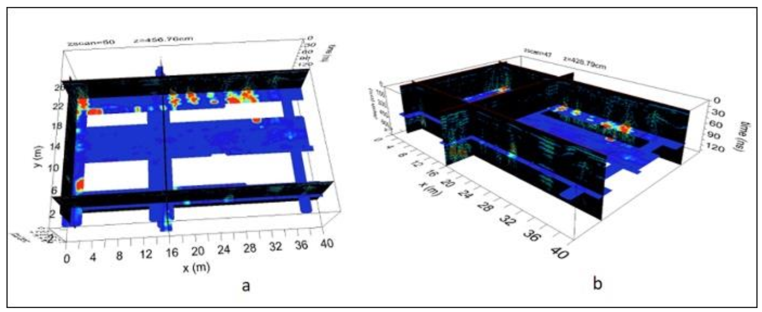
Figure 8.
Lecce Cathedral: GPR profiles along the northern nave (600 MHz antenna).
Figure 8.
Lecce Cathedral: GPR profiles along the northern nave (600 MHz antenna).
Figure 9.
Lecce Cathedral: photo related to the chamber evidenced by GPR surveys.
Figure 9.
Lecce Cathedral: photo related to the chamber evidenced by GPR surveys.
Figure 10.
Lecce Cathedral: GPR profiles along the northern nave (200 MHz antenna).
Figure 10.
Lecce Cathedral: GPR profiles along the northern nave (200 MHz antenna).
Figure 11.
Lecce Cathedral: photo related to the chambers evidenced by GPR surveys in 2018.
Figure 11.
Lecce Cathedral: photo related to the chambers evidenced by GPR surveys in 2018.
Figure 12.
Lecce Cathedral: GPR time slice (200 MHz antenna; depth corresponding to 1.42–1.92 m).
Figure 12.
Lecce Cathedral: GPR time slice (200 MHz antenna; depth corresponding to 1.42–1.92 m).
Figure 13.
Lecce Cathedral: GPR time slice (200 MHz antenna; depth corresponding to 0.70–1.20 m).
Figure 13.
Lecce Cathedral: GPR time slice (200 MHz antenna; depth corresponding to 0.70–1.20 m).
Figure 14.
Lecce Cathedral: GPR time slice (200 MHz antenna; depth corresponding to 5.29–5.79 m).
Figure 14.
Lecce Cathedral: GPR time slice (200 MHz antenna; depth corresponding to 5.29–5.79 m).
Figure 15.
Lecce Cathedral: the 3D visualization shows the distribution of the unknown structures below the cathedral: (a) top view; (b) side view.
Figure 15.
Lecce Cathedral: the 3D visualization shows the distribution of the unknown structures below the cathedral: (a) top view; (b) side view.
| Publisher’s Note: MDPI stays neutral with regard to jurisdictional claims in published maps and institutional affiliations. |
© 2021 by the authors. Licensee MDPI, Basel, Switzerland. This article is an open access article distributed under the terms and conditions of the Creative Commons Attribution (CC BY) license (https://creativecommons.org/licenses/by/4.0/).


