Next Issue
Volume 10, December
Previous Issue
Volume 10, October


Atmosphere, Volume 10, Issue 11 (November 2019) – 88 articles

Cover Story (view full-size image): 
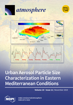
Analysis of long-term particle number size distribution (diameter 0.01–10 µm) measurement in Amman revealed that aerosol concentrations have clear diurnal, weekly, and seasonal characteristics of high concentrations during traffic rush hours, workdays, and winter. The daily mean submicron particle number concentration was 6.5 × 10³–7.7 × 104 cm−3. Ultrafine particles (Dp < 0.1 µm) were 93% of the submicron particles. The modal structure was characterized by five modes (Dpg,I, Ni): nucleation (22 nm, 9.4 × 103 cm−3), Aitken (62 nm, 3.9 × 103 cm−3), accumulation (225 nm, 158 cm−3), coarse (2.23 µm, 1.2 cm−3), and a new particle formation (NPF) mode with a geometric mean diameter of <10 nm. The wind speed and temperature had major impacts on the concentrations. View this paper.
  • Issues are regarded as officially published after their release is announced to the table of contents alert mailing list.
  • You may sign up for e-mail alerts to receive table of contents of newly released issues.
  • PDF is the official format for papers published in both, html and pdf forms. To view the papers in pdf format, click on the "PDF Full-text" link, and use the free Adobe Reader to open them.
Order results
Result details
Section
Select all
Export citation of selected articles as:
25 pages, 4747 KiB  
Article
Evaluation of New CORDEX Simulations Using an Updated Köppen–Trewartha Climate Classification
by Armelle Reca Remedio, Claas Teichmann, Lars Buntemeyer, Kevin Sieck, Torsten Weber, Diana Rechid, Peter Hoffmann, Christine Nam, Lola Kotova and Daniela Jacob
Atmosphere 2019, 10(11), 726; https://0-doi-org.brum.beds.ac.uk/10.3390/atmos10110726 - 19 Nov 2019
Cited by 67 | Viewed by 9218
Abstract
A new ensemble of climate and climate change simulations covering all major inhabited regions with a spatial resolution of about 25 km, from the WCRP CORDEX COmmon Regional Experiment (CORE) Framework, has been established in support of the growing demands for climate services. [...] Read more.
A new ensemble of climate and climate change simulations covering all major inhabited regions with a spatial resolution of about 25 km, from the WCRP CORDEX COmmon Regional Experiment (CORE) Framework, has been established in support of the growing demands for climate services. The main objective of this study is to assess the quality of the simulated climate and its fitness for climate change projections by REMO (REMO2015), a regional climate model of Climate Service Center Germany (GERICS) and one of the RCMs used in the CORDEX-CORE Framework. The CORDEX-CORE REMO2015 simulations were driven by the ECMWF ERA-Interim reanalysis and the simulations were evaluated in terms of biases and skill scores over ten CORDEX Domains against the Climatic Research Unit (CRU) TS version 4.02, from 1981 to 2010, according to the regions defined by the Köppen–Trewartha (K–T) Climate Classification types. The REMO simulations have a relatively low mean annual temperature bias (about ± 0.5 K) with low spatial standard deviation (about ± 1.5 K) in the European, African, North and Central American, and Southeast Asian domains. The relative mean annual precipitation biases of REMO are below ± 50 % in most domains; however, spatial standard deviation varies from ± 30 % to ± 200 %. The REMO results simulated most climate types relatively well with lowest biases and highest skill score found in the boreal, temperate, and subtropical regions. In dry and polar regions, the REMO results simulated a relatively high annual biases of precipitation and temperature and low skill. Biases were traced to: missing or misrepresented processes, observational uncertainty, and uncertainties due to input boundary forcing. Full article
(This article belongs to the Section Meteorology)
Show Figures

Figure 1

13 pages, 2358 KiB  
Article
Effect of Human-Induced Land Disturbance on Subseasonal Predictability of Near-Surface Variables Using an Atmospheric General Circulation Model
by Tomohito J. Yamada and Yadu Pokhrel
Atmosphere 2019, 10(11), 725; https://0-doi-org.brum.beds.ac.uk/10.3390/atmos10110725 - 19 Nov 2019
Cited by 5 | Viewed by 2991
Abstract
Irrigation can affect climate and weather patterns from regional to global scales through the alteration of surface water and energy balances. Here, we couple a land-surface model (LSM) that includes various human land-water management activities including irrigation with an atmospheric general circulation model [...] Read more.
Irrigation can affect climate and weather patterns from regional to global scales through the alteration of surface water and energy balances. Here, we couple a land-surface model (LSM) that includes various human land-water management activities including irrigation with an atmospheric general circulation model (AGCM) to examine the impacts of irrigation-induced land disturbance on the subseasonal predictability of near-surface variables. Results indicate that the simulated global irrigation and groundwater withdrawals (circa 2000) are ~3600 and ~370 km3/year, respectively, which are in good agreement with previous estimates from country statistics and offline–LSMs. Subseasonal predictions for boreal summers during the 1986–1995 period suggest that the spread among ensemble simulations of air temperature can be substantially reduced by using realistic land initializations considering irrigation-induced changes in soil moisture. Additionally, it is found that the subseasonal forecast skill for near-surface temperature and sea level pressure significantly improves when human-induced land disturbance is accounted for in the AGCM. These results underscore the need to incorporate irrigation into weather forecast models, such as the global forecast system. Full article
Show Figures

Figure 1

20 pages, 7606 KiB  
Article
Observing and Modeling the Response of Placentia Bay to an Extratropical Cyclone
by Guangjun Xu, Guoqi Han, Changming Dong, Jingsong Yang and Brad DeYoung
Atmosphere 2019, 10(11), 724; https://0-doi-org.brum.beds.ac.uk/10.3390/atmos10110724 - 19 Nov 2019
Cited by 2 | Viewed by 2648
Abstract
An extratropical cyclone reported to have the largest wind speed in Newfoundland in more
than a decade landed on the island of Newfoundland on 11 March 2017. The oceanic responses in
Placentia Bay on the southeast coast of Newfoundland to the winter storm [...] Read more.
An extratropical cyclone reported to have the largest wind speed in Newfoundland in more
than a decade landed on the island of Newfoundland on 11 March 2017. The oceanic responses in
Placentia Bay on the southeast coast of Newfoundland to the winter storm were examined using
observed data and the Finite-Volume Community Ocean Model (FVCOM). The peak non-tidal water
level increase, i.e., storm surge, reached 0.85mat St. Lawrence and 0.77mat Argentia on Placentia Bay.
Sea surface temperature slightly decreased after the storm passage according to buoy and satellite
measurements. Root mean square dierences (RMSD) of the magnitude of storm surge between model
results and observations are 0.15 m. The model sea surface temperature showed a small decrease,
consistent with observations, with RMSDs from 0.19 to 0.64 C at buoy stations. The simulated
surface current changes agree with buoy observations, with model-observation velocity dierence
ratios (VDR) of 0.75–0.88. It was found that, at Argentia (St. Lawrence), the peak storm surge in
Placentia Bay was dominantly (moderately) associated with the inverse barometric eect, and the
subsequent negative surge was mainly due to the wind eect at both stations. The sea surface cooling
was associated with oceanic heat loss. In the momentum balance, the Coriolis, pressure gradient,
and advection terms were all important during the storm, while the first two terms were predominant
before and after the storm. Full article
(This article belongs to the Special Issue Disentangling Atmosphere-Ocean Interactions, from Weather to Climate)
Show Figures

Figure 1

18 pages, 6308 KiB  
Article
Impact of Sea Breeze Circulation on the Transport of Ship Emissions in Tangshan Port, China
by Fang Shang, Dongsheng Chen, Xiurui Guo, Jianlei Lang, Ying Zhou, Yue Li and Xinyi Fu
Atmosphere 2019, 10(11), 723; https://0-doi-org.brum.beds.ac.uk/10.3390/atmos10110723 - 18 Nov 2019
Cited by 22 | Viewed by 5486
Abstract
A sea breeze is a local circulation that occurs in coastal regions from the poles to the equator. The adverse influence of ship emissions on air quality in coastal areas may be aggravated by the onshore flow of sea breeze circulation. However, our [...] Read more.
A sea breeze is a local circulation that occurs in coastal regions from the poles to the equator. The adverse influence of ship emissions on air quality in coastal areas may be aggravated by the onshore flow of sea breeze circulation. However, our knowledge regarding the evolution of ship-emitted pollutants during a specific sea breeze episode is still limited. To address this knowledge gap, this study investigated the evolution of ship emissions during a sea breeze episode that occurred on 29 June, 2014 in Tangshan port in China by employing the WRF/Chem model. NO2, one of the primary pollutants emitted by ships, was selected as the target pollutant for investigation. The results indicate that the ground level NO2 concentration was considerably affected by sea breeze circulation. Although the onset of the sea breeze was delayed until nearly midday due to offshore synoptic winds, ship-emitted NO2 was transported to more than 100 km inland with the penetration of the sea breeze. Further investigation found that the averaged concentration of ship-contributed NO2 during the episode showed an evident downward trend as the distance from the coastline increased. Vertically, the shallow atmospheric boundary layer (ABL) on the sea limited the vertical dispersion of ship emissions, and the pollutant was transported shoreward by the sea breeze within this shallow ABL. The height of the ABLs is lowered in coastal regions due to the cooling effect of sea breezes which brings the cool marine air to the hot land surface. Ship-contributed NO2 was mostly trapped in the shallow ABL; thereby, its concentration increased. Full article
(This article belongs to the Special Issue Pollutant Dispersion in the Atmospheric Boundary Layer)
Show Figures

Figure 1

26 pages, 14844 KiB  
Article
Observational Analysis of the Characteristics of the Synoptic Situation and Evolution of the Organized Warm-Sector Rainfall in the Coastal Region of South China in the Pre-Summer Rainy Season
by Zhaoming Liang, Robert G. Fovell and Ying Liu
Atmosphere 2019, 10(11), 722; https://0-doi-org.brum.beds.ac.uk/10.3390/atmos10110722 - 18 Nov 2019
Cited by 4 | Viewed by 3051
Abstract
The characteristics of the synoptic situation and the evolution of the organized warm-sector rainfalls (OWSRs) in the coastal region of South China in the pre-summer rainy season were investigated, using a period (2011–2016) of high-resolution observational data and European Centre for Medium-Range Weather [...] Read more.
The characteristics of the synoptic situation and the evolution of the organized warm-sector rainfalls (OWSRs) in the coastal region of South China in the pre-summer rainy season were investigated, using a period (2011–2016) of high-resolution observational data and European Centre for Medium-Range Weather Forecasts Re-Analysis Interim (ERA-Interim) data. The results show that a strong southwesterly low-level jet (LLJ) ahead of a trough over southwestern China with a marked boundary-layer jet (BLJ) over the northern South China Sea (synoptic situation SWLLJ) or a prominent, low-level anticyclone over the Yangtze River Basin (synoptic situation ACR) is present when the OWSRs occur in the coastal region of South China. The OWSRs are prone to initiate on the windward side of the coastal mountains, owing to the convergence enhanced by the colliding of the BLJ with the mountains and the coupling of double LLJs near the coast (for SWLLJ), or due to the convergence between northerly and southeasterly winds near the coastal mountains (for ACR). The OWSRs present a long extension when the LLJ axis is nearby. The translation of the LLJ itself also promotes the long extension of the OWSRs. In contrast, the OWSRs show a short extension when the LLJ axis is farther away or ACR occurs. Meanwhile, the OWSRs are directed northeastward in Guangxi Province and more eastward in Guangdong Province, probably owing to the orientation difference of the LLJ in these two provinces. The rainfall systems in the ACR situation tend to move eastward, whereas those in the SWLLJ situation are prone to move eastward when equivalently strong or much-stronger upper-level winds overlay the LLJ, but move northeastward when much weaker upper-level winds couple with the LLJ. Full article
(This article belongs to the Section Meteorology)
Show Figures

Figure 1

26 pages, 5381 KiB  
Article
Intercomparison of Ground- and Satellite-Based Total Ozone Data Products at Marambio Base, Antarctic Peninsula Region
by Klára Čížková, Kamil Láska, Ladislav Metelka and Martin Staněk
Atmosphere 2019, 10(11), 721; https://0-doi-org.brum.beds.ac.uk/10.3390/atmos10110721 - 18 Nov 2019
Cited by 1 | Viewed by 3538
Abstract
This study aims to compare the ground-based Brewer spectrophotometer total ozone column measurements with the Dobson spectrophotometer and various satellite overpass data available at Marambio Base during the period 2011–2013. This station provides a unique opportunity to study ozone variability near the edge [...] Read more.
This study aims to compare the ground-based Brewer spectrophotometer total ozone column measurements with the Dobson spectrophotometer and various satellite overpass data available at Marambio Base during the period 2011–2013. This station provides a unique opportunity to study ozone variability near the edge of the southern polar vortex; therefore, many institutions, such as the National Meteorological Service of Argentina, the Finnish Meteorological Institute and the Czech Hydrometeorological Institute, have been carrying out various scientific activities there. The intercomparison was performed using total ozone column data sets retrieved from the ground-based instruments and from Ozone Monitoring Instrument (OMI)—Total Ozone Mapping Spectrometer (TOMS), OMI–Differential Optical Absorption Spectroscopy (DOAS), Global Ozone Monitoring Experiment 2 (GOME2), and Scanning Imaging Absorption Spectrophotometer for Atmospheric Cartography (SCIAMACHY) satellite observations. To assess the quality of the selected data products, comparisons with reference to the Brewer spectrophotometer single observations were made. The performance of the satellite observational techniques was assessed against the solar zenith angle and effective temperature, as well as against the actual shape of the vertical ozone profiles, which represent an important input parameter for the satellite ozone retrievals. The ground-based Dobson observations showed the best agreement with the Brewer data set (R2 = 1.00, RMSE = 1.5%); however, significant solar zenith angle (SZA) dependency was found. The satellite overpass data confirmed good agreement with the Brewer observations but were, however, overestimated in all cases except for the OMI(TOMS), when the mean bias differed from −0.7 DU in the case of the OMI(TOMS) to 6.4 DU for the SCIAMACHY. The differences in satellite observational techniques were further evaluated using statistical analyses adapted for depleted and non-depleted conditions over the ozone hole period. Full article
(This article belongs to the Special Issue Stratospheric Ozone: In Situ and Remote Sensing Observation)
Show Figures

Figure 1

11 pages, 3955 KiB  
Article
Recently Strengthened Influence of ENSO on the Wintertime East Asian Surface Air Temperature
by Hainan Gong, Lin Wang and Wen Chen
Atmosphere 2019, 10(11), 720; https://0-doi-org.brum.beds.ac.uk/10.3390/atmos10110720 - 18 Nov 2019
Cited by 12 | Viewed by 2603
Abstract
Previous studies have indicated that El Niño–Southern Oscillation (ENSO) exerts a significant influence on the East Asian winter climate. This study reveals an interdecadal strengthening of the connection between ENSO and the East Asian surface air temperature (EAT) connection around the late 1990s [...] Read more.
Previous studies have indicated that El Niño–Southern Oscillation (ENSO) exerts a significant influence on the East Asian winter climate. This study reveals an interdecadal strengthening of the connection between ENSO and the East Asian surface air temperature (EAT) connection around the late 1990s and investigates the reason for this change. Before the late 1990s, the influence of ENSO on the EAT was weak, and the ENSO-related southerly wind anomalies were confined to the south of 30° N of East Asia. After the late 1990s, by contrast, ENSO’s influence became stronger and capable of extending northward to 50° N of East Asia. The decadal strengthening of the link between ENSO and EAT is primarily modulated by the magnitudes of the ENSO-related Kuroshio anticyclone. The intensity of the Kuroshio anticyclone contributes more than 50% of the variance of the oscillational ENSO–EAT variability. Further investigation indicates that the recovered magnitude of the Kuroshio anticyclone after the late 1990s has been closely tied to the eastward shrinking of the Aleutian Low (AL) pattern, which has weakened the link of atmospheric circulation between the AL and Kuroshio Extension region. Therefore, the offset effect of the AL-induced negative (positive) sea level pressure (SLP) anomalies on the El Niño (La Niña)-induced positive (negative) SLP anomalies over the Kuroshio Extension has also been weakened, which has facilitated the recovery of the significant influence of ENSO on the EAT. Full article
(This article belongs to the Section Meteorology)
Show Figures

Figure 1

18 pages, 8647 KiB  
Article
The Causes of “Vulnerable Regions” to Air Pollution in Winter in the Beijing-Tianjin-Hebei Region: A Topographic–Meteorological Impact Model Based on Adaptive Emission Constraint Technique
by Kai Meng, Xiangde Xu, Xiaobin Xu, Haoliang Wang, Xiaohui Liu and Yayin Jiao
Atmosphere 2019, 10(11), 719; https://0-doi-org.brum.beds.ac.uk/10.3390/atmos10110719 - 16 Nov 2019
Cited by 11 | Viewed by 3018
Abstract
The Beijing-Tianjin-Hebei (BTH) region, with its complex terrain, has serious issues with air pollution. The northern and western parts of the BTH region are surrounded by the Yan Mountains and Loess Plateau (LP), and the south-central part of that region is a large [...] Read more.
The Beijing-Tianjin-Hebei (BTH) region, with its complex terrain, has serious issues with air pollution. The northern and western parts of the BTH region are surrounded by the Yan Mountains and Loess Plateau (LP), and the south-central part of that region is a large open plain. Such special geographic configuration is prone to result in a concentrated pollution belt along the north-to-south direction on the eastern margin of the plateau, in addition to the influence of pollutant-emission sources and population distribution. In this study, based on an original adaptive nudging constraint method, we quantitatively analyzed the differences in the influence of emission sources under different dynamic and thermal conditions in the BTH region, which is impacted by a special large-scale leeward slope terrain. The mechanism of air pollution vulnerability and the comprehensive effects of terrain–meteorological conditions on air pollution in the BTH region were also discussed. The results indicated that the atmospheric diffusion conditions on the eastern side of the plateau were poor, and a sub-synoptic-scale “vortex sequence”, which was composed of a series of linked vortices, was identified. The corresponding atmospheric pollution convergence line stretched from Beijing to Hebei to Northern Henan in the lower atmosphere. On the eastern edge of the plateau, a “warm cover” formed by a temperature anomaly and a downdraft impeded the vertical diffusion of pollutants. Therefore, pollutants tended to converge at the eastern edge of the plateau, and the pollution belts would move longitudinally north and south along the topography of the eastern slope when south-westerly and north-easterly winds alternated. The movement generated a “train” of pollutants that were transported on the eastern edge of the plateau, which then caused air pollution to persist there. Such terrain–meteorological conditions amplified the effects of emissions by an average of 50% to 150% in the region, leading the eastern side of the LP to become a “naturally vulnerable region” to haze pollution. Full article
(This article belongs to the Section Air Quality)
Show Figures

Figure 1

16 pages, 6902 KiB  
Article
Temperature Prediction Using the Missing Data Refinement Model Based on a Long Short-Term Memory Neural Network
by Inyoung Park, Hyun Soo Kim, Jiwon Lee, Joon Ha Kim, Chul Han Song and Hong Kook Kim
Atmosphere 2019, 10(11), 718; https://0-doi-org.brum.beds.ac.uk/10.3390/atmos10110718 - 16 Nov 2019
Cited by 43 | Viewed by 6982
Abstract
In this paper, we propose a new temperature prediction model based on deep learning by using real observed weather data. To this end, a huge amount of model training data is needed, but these data should not be defective. However, there is a [...] Read more.
In this paper, we propose a new temperature prediction model based on deep learning by using real observed weather data. To this end, a huge amount of model training data is needed, but these data should not be defective. However, there is a limitation in collecting weather data since it is not possible to measure data that have been missed. Thus, the collected data are apt to be incomplete, with random or extended gaps. Therefore, the proposed temperature prediction model is used to refine missing data in order to restore missed weather data. In addition, since temperature is seasonal, the proposed model utilizes a long short-term memory (LSTM) neural network, which is a kind of recurrent neural network known to be suitable for time-series data modeling. Furthermore, different configurations of LSTMs are investigated so that the proposed LSTM-based model can reflect the time-series traits of the temperature data. In particular, when a part of the data is detected as missing, it is restored by using the proposed model’s refinement function. After all the missing data are refined, the LSTM-based model is retrained using the refined data. Finally, the proposed LSTM-based temperature prediction model can predict the temperature through three time steps: 6, 12, and 24 h. Furthermore, the model is extended to predict 7 and 14 day future temperatures. The performance of the proposed model is measured by its root-mean-squared error (RMSE) and compared with the RMSEs of a feedforward deep neural network, a conventional LSTM neural network without any refinement function, and a mathematical model currently used by the meteorological office in Korea. Consequently, it is shown that the proposed LSTM-based model employing LSTM-refinement achieves the lowest RMSEs for 6, 12, and 24 h temperature prediction as well as for 7 and 14 day temperature prediction, compared to other DNN-based and LSTM-based models with either no refinement or linear interpolation. Moreover, the prediction accuracy of the proposed model is higher than that of the Unified Model (UM) Local Data Assimilation and Prediction System (LDAPS) for 24 h temperature predictions. Full article
Show Figures

Graphical abstract

10 pages, 423 KiB  
Article
Geographical Imputation of Missing Poaceae Pollen Data via Convolutional Neural Networks
by Ricardo Navares and José Luis Aznarte
Atmosphere 2019, 10(11), 717; https://0-doi-org.brum.beds.ac.uk/10.3390/atmos10110717 - 16 Nov 2019
Cited by 5 | Viewed by 2226
Abstract
Airborne pollen monitoring datasets sometimes exhibit gaps, even very long, either because of maintenance or because of a lack of expert personnel. Despite the numerous imputation techniques available, not all of them effectively include the spatial relations of the data since the assumption [...] Read more.
Airborne pollen monitoring datasets sometimes exhibit gaps, even very long, either because of maintenance or because of a lack of expert personnel. Despite the numerous imputation techniques available, not all of them effectively include the spatial relations of the data since the assumption of missing-at-random is made. However, there are several techniques in geostatistics that overcome this limitation such as the inverse distance weighting and Gaussian processes or kriging. In this paper, a new method is proposed that utilizes convolutional neural networks. This method not only shows a competitive advantage in terms of accuracy when compared to the aforementioned techniques by improving the error by 5% on average, but also reduces execution training times by 90% when compared to a Gaussian process. To show the advantages of the proposal, 10%, 20%, and 30% of the data points are removed in the time series of a Poaceae pollen observation station in the region of Madrid, and the airborne concentrations from the remaining available stations in the network are used to impute the data removed. Even though the improvements in terms of accuracy are not significantly large, even if consistent, the gain in computational time and the flexibility of the proposed convolutional neural network allow field experts to adapt and extend the solution, for instance including meteorological variables, with the potential decrease of the errors reported in this paper. Full article
(This article belongs to the Special Issue GIS Applications for Airborne Pollen Monitoring and Prediction)
Show Figures

Figure 1

19 pages, 6648 KiB  
Article
Horizontal Vortex Tubes near a Simulated Tornado: Three-Dimensional Structure and Kinematics
by Maurício I. Oliveira, Ming Xue, Brett J. Roberts, Louis J. Wicker and Nusrat Yussouf
Atmosphere 2019, 10(11), 716; https://0-doi-org.brum.beds.ac.uk/10.3390/atmos10110716 - 16 Nov 2019
Cited by 4 | Viewed by 8841
Abstract
Supercell thunderstorms can produce a wide spectrum of vortical structures, ranging from midlevel mesocyclones to small-scale suction vortices within tornadoes. A less documented class of vortices are horizontally-oriented vortex tubes near and/or wrapping about tornadoes, that are observed either visually or in high-resolution [...] Read more.
Supercell thunderstorms can produce a wide spectrum of vortical structures, ranging from midlevel mesocyclones to small-scale suction vortices within tornadoes. A less documented class of vortices are horizontally-oriented vortex tubes near and/or wrapping about tornadoes, that are observed either visually or in high-resolution Doppler radar data. In this study, an idealized numerical simulation of a tornadic supercell at 100 m grid spacing is used to analyze the three-dimensional (3D) structure and kinematics of horizontal vortices (HVs) that interact with a simulated tornado. Visualizations based on direct volume rendering aided by visual observations of HVs in a real tornado reveal the existence of a complex distribution of 3D vortex tubes surrounding the tornadic flow throughout the simulation. A distinct class of HVs originates in two key regions at the surface: around the base of the tornado and in the rear-flank downdraft (RFD) outflow and are believed to have been generated via surface friction in regions of strong horizontal near-surface wind. HVs around the tornado are produced in the tornado outer circulation and rise abruptly in its periphery, assuming a variety of complex shapes, while HVs to the south-southeast of the tornado, within the RFD outflow, ascend gradually in the updraft. Full article
(This article belongs to the Special Issue Simulation and Visualization of Severe Weather)
Show Figures

Figure 1

12 pages, 4240 KiB  
Article
Spatial Variability of the Lower Atmospheric Boundary Layer over Hilly Terrain as Observed with an RPAS
by Joan Cuxart, Burkhard Wrenger, Blazenka Matjacic and Larry Mahrt
Atmosphere 2019, 10(11), 715; https://0-doi-org.brum.beds.ac.uk/10.3390/atmos10110715 - 15 Nov 2019
Cited by 9 | Viewed by 2593
Abstract
The operation of a Remotely Piloted Aircraft System (RPAS) over a hilly area in northern Germany allows inspection of the variability of the profiles of temperature, humidity, and wind speed next to a small hill. Four cases in nearly stationary conditions are analyzed. [...] Read more.
The operation of a Remotely Piloted Aircraft System (RPAS) over a hilly area in northern Germany allows inspection of the variability of the profiles of temperature, humidity, and wind speed next to a small hill. Four cases in nearly stationary conditions are analyzed. Two events are windy, one overcast and the other with clear skies, whereas the two other cases have weak winds, one overcast, and one with clear skies and dissipating mist. The profiles are made at five locations surrounding the hill, separated by a distance from each other of 5 km at most, sampling up to 130 m above the ground. The average profiles and their standard deviations indicate that the variability in the windy cases is approximately constant with height, likely linked to the turbulent flow itself, whereas, for the weak wind cases, the variability diminishes with height, and it is probably linked to the surface variability. The variability between soundings is large. The computation of the root mean square error with respect to the average of the soundings for each case shows that the site closest to the average is the one over open terrain and low vegetation, whereas the site in the forest is the farthest from average. Comparison with the profiles to the nearest grid point of the European Centre for Medium-Range Weather Forecasts (ECMWF) model shows that the closest values are provided by the average of the soundings and by the site closest to the average. Despite the small dataset collected during this exercise, the methodology developed here can be used for more cases and locations with the aim to characterize better the local variability in the lower atmosphere. In this sense, a non-dimensional heterogeneity index is proposed to quantify the topographically and thermally induced variability in complex terrain. Full article
(This article belongs to the Special Issue Measurement of Atmospheric Composition by Unmanned Aerial Systems)
Show Figures

Figure 1

24 pages, 385 KiB  
Review
Polarization Weather Radar Development from 1970–1995: Personal Reflections
by Viswanathan Bringi and Dusan Zrnic
Atmosphere 2019, 10(11), 714; https://0-doi-org.brum.beds.ac.uk/10.3390/atmos10110714 - 15 Nov 2019
Cited by 8 | Viewed by 4197
Abstract
The modern era of polarimetric radar begins with radiowave propagation research starting in the early 1970s with applications to measurement and modeling of wave attenuation in rain and depolarization due to ice particles along satellite–earth links. While there is a rich history of [...] Read more.
The modern era of polarimetric radar begins with radiowave propagation research starting in the early 1970s with applications to measurement and modeling of wave attenuation in rain and depolarization due to ice particles along satellite–earth links. While there is a rich history of radar in meteorology after World War II, the impetus provided by radiowave propagation requirements led to high-quality antennas and feeds. Our journey starts by describing the key institutions and personnel responsible for development of weather radar polarimetry. The early period was dominated by circularly polarized radars for propagation research and at S band (frequency near 3 GHz) for hail detection. By the mid to late 70s, a paradigm shift occurred which led to the dominance of linear polarizations with applications to slant path attenuation prediction as well as estimation of rain rates and inferences of precipitation physics. The period from the early 1980s to 1995 can be considered as the “golden” period of rapid research that brought in meteorologists, cloud physicists, and hydrologists. This article describes the evolution of this technology from the vantage point of the authors. Their personal reflections and “behind the scenes” descriptions offer a glimpse into the inner workings at several key institutions which cannot be found elsewhere. Full article
(This article belongs to the Special Issue Electromagetics and Polarimetric Weather Radar)
21 pages, 612 KiB  
Article
Validation of the Water Vapor Profiles of the Raman Lidar at the Maïdo Observatory (Reunion Island) Calibrated with Global Navigation Satellite System Integrated Water Vapor
by Hélène Vérèmes, Guillaume Payen, Philippe Keckhut, Valentin Duflot, Jean-Luc Baray, Jean-Pierre Cammas, Stéphanie Evan, Françoise Posny, Susanne Körner and Pierre Bosser
Atmosphere 2019, 10(11), 713; https://0-doi-org.brum.beds.ac.uk/10.3390/atmos10110713 - 15 Nov 2019
Cited by 7 | Viewed by 3178
Abstract
The Maïdo high-altitude observatory located in Reunion Island (21° S, 55.5° E) is equipped with the Lidar1200, an innovative Raman lidar designed to measure the water vapor mixing ratio in the troposphere and the lower stratosphere, to perform long-term survey and processes studies [...] Read more.
The Maïdo high-altitude observatory located in Reunion Island (21° S, 55.5° E) is equipped with the Lidar1200, an innovative Raman lidar designed to measure the water vapor mixing ratio in the troposphere and the lower stratosphere, to perform long-term survey and processes studies in the vicinity of the tropopause. The calibration methodology is based on a GNSS (Global Navigation Satellite System) IWV (Integrated Water Vapor) dataset. The lidar water vapor measurements from November 2013 to October 2015 have been calibrated according to this methodology and used to evaluate the performance of the lidar. The 2-year operation shows that the calibration uncertainty using the GNSS technique is in good agreement with the calibration derived using radiosondes. During the MORGANE (Maïdo ObservatoRy Gaz and Aerosols NDACC Experiment) campaign (Reunion Island, May 2015), CFH (Cryogenic Frost point Hygrometer) radiosonde and Raman lidar profiles are compared and show good agreement up to 22 km asl; no significant biases are detected and mean differences are smaller than 9% up to 22 km asl. Full article
Show Figures

Figure 1

16 pages, 2117 KiB  
Article
Impacts of 1.5 and 2.0 °C Global Warming on Water Balance Components over Senegal in West Africa
by Mamadou Lamine Mbaye, Mouhamadou Bamba Sylla and Moustapha Tall
Atmosphere 2019, 10(11), 712; https://0-doi-org.brum.beds.ac.uk/10.3390/atmos10110712 - 15 Nov 2019
Cited by 10 | Viewed by 3903
Abstract
This study assesses the changes in precipitation (P) and in evapotranspiration (ET) under 1.5 °C and 2.0 °C global warming levels (GWLs) over Senegal in West Africa. A set of twenty Regional Climate Model (RCM) simulations within the Coordinated Regional Downscaling Experiment (CORDEX) [...] Read more.
This study assesses the changes in precipitation (P) and in evapotranspiration (ET) under 1.5 °C and 2.0 °C global warming levels (GWLs) over Senegal in West Africa. A set of twenty Regional Climate Model (RCM) simulations within the Coordinated Regional Downscaling Experiment (CORDEX) following the Representative Concentration Pathways (RCP) 4.5 emission scenario is used. Annual and seasonal changes are computed between climate simulations under 1.5 °C and 2.0 °C warming, with respect to 0.5 °C warming, compared to pre-industrial levels. The results show that annual precipitation is likely to decrease under both magnitudes of warming; this decrease is also found during the main rainy season (July, August, September) only and is more pronounced under 2 °C warming. All reference evapotranspiration calculations, from Penman, Hamon, and Hargreaves formulations, show an increase in the future under the two GWLs, except annual Penman evapotranspiration under the 1.5 °C warming scenario. Furthermore, seasonal and annual water balances (P-ET) generally exhibit a water deficit. This water deficit (up to 180 mm) is more substantial with Penman and Hamon under 2 °C. In addition, analyses of changes in extreme precipitation reveal an increase in dry spells and a decrease in the number of wet days. However, Senegal may face a slight increase in very wet days (95th percentile), extremely wet days (99th), and rainfall intensity in the coming decades. Therefore, in the future, Senegal may experience a decline in precipitation, an increase of evapotranspiration, and a slight increase in heavy rainfall. Such changes could have serious consequences (e.g., drought, flood, etc.) for socioeconomic activities. Thus, strong governmental politics are needed to restrict the global mean temperature to avoid irreversible negative climate change impacts over the country. The findings of this study have contributed to a better understanding of local patterns of the Senegal hydroclimate under the two considered global warming scenarios. Full article
(This article belongs to the Special Issue Trends in Hydrological and Climate Extremes in Africa)
Show Figures

Figure 1

13 pages, 2977 KiB  
Article
Determination of the Structural Characteristic of the Refractive Index of Optical Waves in the Atmospheric Boundary Layer with Remote Acoustic Sounding Facilities
by Sergei L. Odintsov, Vladimir A. Gladkikh, Andrei P. Kamardin and Irina V. Nevzorova
Atmosphere 2019, 10(11), 711; https://0-doi-org.brum.beds.ac.uk/10.3390/atmos10110711 - 14 Nov 2019
Cited by 15 | Viewed by 3121
Abstract
The structural characteristic of the refractive index of optical waves was calculated from experimental data on the microstructure of the temperature turbulence in the atmospheric boundary layer. The experimental data were obtained with an acoustic meteorological radar (sodar), ultrasonic anemometer–thermometer, and meteorological temperature [...] Read more.
The structural characteristic of the refractive index of optical waves was calculated from experimental data on the microstructure of the temperature turbulence in the atmospheric boundary layer. The experimental data were obtained with an acoustic meteorological radar (sodar), ultrasonic anemometer–thermometer, and meteorological temperature profilometer. Estimates of the structural characteristics for different conditions in the atmospheric boundary layer are presented and were compared with model profiles. Full article
(This article belongs to the Special Issue Atmospheric Turbulence Measurements and Calibration)
Show Figures

Figure 1

21 pages, 5908 KiB  
Article
Urban Aerosol Particle Size Characterization in Eastern Mediterranean Conditions
by Tareq Hussein, Lubna Dada, Simo Hakala, Tuukka Petäjä and Markku Kulmala
Atmosphere 2019, 10(11), 710; https://0-doi-org.brum.beds.ac.uk/10.3390/atmos10110710 - 14 Nov 2019
Cited by 13 | Viewed by 4809
Abstract
Characterization of urban particle number size distribution (PNSD) has been rarely reported/performed in the Middle East. Therefore, we aimed at characterizing the PNSD (0.01–10 µm) in Amman as an example for an urban Middle Eastern environment. The daily mean submicron particle [...] Read more.
Characterization of urban particle number size distribution (PNSD) has been rarely reported/performed in the Middle East. Therefore, we aimed at characterizing the PNSD (0.01–10 µm) in Amman as an example for an urban Middle Eastern environment. The daily mean submicron particle number concentration (PNSub) was 6.5 × 10³–7.7 × 104 cm−3 and the monthly mean coarse mode particle number concentration (PNCoarse) was 0.9–3.8 cm−3 and both had distinguished seasonal variation. The PNSub also had a clear diurnal and weekly cycle with higher concentrations on workdays (Sunday–Thursday; over 3.3 × 104 cm−3) than on weekends (below 2.7 × 104 cm−3). The PNSub constitute of 93% ultrafine fraction (diameter < 100 nm). The mean particle number size distributions was characterized with four well-separated submicron modes (Dpg,I, Ni): nucleation (22 nm, 9.4 × 103 cm−3), Aitken (62 nm, 3.9 × 103 cm−3), accumulation (225 nm, 158 cm−3), and coarse (2.23 µm, 1.2 cm−3) in addition to a mode with small geometric mean diameter (GMD) that represented the early stage of new particle formation (NPF) events. The wind speed and temperature had major impacts on the concentrations. The PNCoarse had a U-shape with respect to wind speed and PNSub decreased with wind speed. The effect of temperature and relative humidity was complex and require further investigations. Full article
(This article belongs to the Special Issue Urban Atmospheric Aerosols: Sources, Analysis and Effects)
Show Figures

Figure 1

14 pages, 5221 KiB  
Article
Aerosol Optical Depth of the Main Aerosol Species over Italian Cities Based on the NASA/MERRA-2 Model Reanalysis
by Umberto Rizza, Enrico Mancinelli, Mauro Morichetti, Giorgio Passerini and Simone Virgili
Atmosphere 2019, 10(11), 709; https://0-doi-org.brum.beds.ac.uk/10.3390/atmos10110709 - 14 Nov 2019
Cited by 21 | Viewed by 5483
Abstract
The Modern-Era Retrospective Analysis for Research and Applications, version 2 (MERRA-2) provides data at 0.5° × 0.625° resolution covering a period from 1 January 1980 to the present. Natural and anthropogenic aerosols are simulated in MERRA-2, considering the Goddard chemistry, aerosol, radiation, and [...] Read more.
The Modern-Era Retrospective Analysis for Research and Applications, version 2 (MERRA-2) provides data at 0.5° × 0.625° resolution covering a period from 1 January 1980 to the present. Natural and anthropogenic aerosols are simulated in MERRA-2, considering the Goddard chemistry, aerosol, radiation, and transport model. This model simulates the sources, sinks, and chemistry of mixed aerosol tracers: dust, sea salt, hydrophobic and hydrophilic black carbon and organic carbon, and sulfate. MERRA-2 aerosol reanalysis is a pioneering tool for investigating air quality issues, noteworthy for its global coverage and its distinction of aerosol speciation expressed in the form of aerosol optical depth (AOD). The aim of this work was to use the MERRA-2 reanalysis to study urban air pollution at a national scale by analyzing the AOD. AOD trends were evaluated for a 30-year period (1987–2017) over five Italian cities (Milan, Rome, Cagliari, Taranto, and Palermo) in order to investigate the impacts of urbanization, industrialization, air quality regulations, and regional transport on urban aerosol load. AOD evolution predicted by the MERRA-2 model in the period 2002–2017 showed a generalized decreasing trend over the selected cities. The anthropogenic signature on total AOD was between 50% and 80%, with the largest contribution deriving from sulfate. Full article
(This article belongs to the Special Issue Recent Advances of Air Pollution Studies in Italy)
Show Figures

Figure 1

17 pages, 3411 KiB  
Article
Variations in Greenhouse Gas Fluxes in Response to Short-Term Changes in Weather Variables at Three Elevation Ranges, Wakiso District, Uganda
by Nakiguli Fatumah, Linus K. Munishi and Patrick A. Ndakidemi
Atmosphere 2019, 10(11), 708; https://0-doi-org.brum.beds.ac.uk/10.3390/atmos10110708 - 14 Nov 2019
Cited by 8 | Viewed by 3101
Abstract
Weather conditions are among the major factors leading to the increasing greenhouse gas (GHG) fluxes from the agricultural soils. In this study, variations in the soil GHG fluxes with precipitation and soil temperatures at different elevation ranges in banana–coffee farms, in the Wakiso [...] Read more.
Weather conditions are among the major factors leading to the increasing greenhouse gas (GHG) fluxes from the agricultural soils. In this study, variations in the soil GHG fluxes with precipitation and soil temperatures at different elevation ranges in banana–coffee farms, in the Wakiso District, Uganda, were evaluated. The soil GHG fluxes were collected weekly, using the chamber method, and analyzed by using gas chromatography. Parallel soil temperature samples were collected by using a REOTEMP soil thermometer. Daily precipitation was measured with an automated weather station instrument installed on-site. The results showed that CO2, N2O, and CH4 fluxes were significantly different between the sites at different elevation ranges. Daily precipitation and soil temperatures significantly (p < 0.05) affected the soil GHG fluxes. Along an elevation gradient, daily precipitation and soil temperatures positively associated with the soil GHG fluxes. The combined factors of daily precipitation and soil temperatures also influence the soil GHG fluxes, but their effect was less than that of the single effects. Overall, daily precipitation and soil temperatures are key weather factors driving the soil GHG fluxes in time and space. This particular study suggests that agriculture at lower elevation levels would help reduce the magnitudes of the soil GHG fluxes. However, this study did not measure the soil GHG fluxes from the non-cultivated ecosystems. Therefore, future studies should focus on assessing the variations in the soil GHG fluxes from non-cultivated ecosystems relative to agriculture systems, at varying elevation ranges. Full article
Show Figures

Figure 1

21 pages, 6157 KiB  
Article
Influences of the Atlantic and Pacific Oceans on Rainy Season Precipitation for the Southernmost Caribbean Small Island State, Trinidad
by Nkese D. Mc Shine, Ricardo M. Clarke, Silvio Gualdi, Antonio Navarra and Xsitaaz T. Chadee
Atmosphere 2019, 10(11), 707; https://0-doi-org.brum.beds.ac.uk/10.3390/atmos10110707 - 13 Nov 2019
Cited by 2 | Viewed by 2632
Abstract
Seasonal rainfall in the Caribbean Basin is known to be modulated by sea surface temperature anomalies (SSTAs) in the Atlantic and Pacific Oceans, and particularly those in the Equatorial Pacific and Atlantic and the Tropical North Atlantic. However, little is known about how [...] Read more.
Seasonal rainfall in the Caribbean Basin is known to be modulated by sea surface temperature anomalies (SSTAs) in the Atlantic and Pacific Oceans, and particularly those in the Equatorial Pacific and Atlantic and the Tropical North Atlantic. However, little is known about how these major oceans influence the seasonal precipitation of individual small island states within the region as climate variability at the island-scale may differ from the Caribbean as a whole. Correlation and composite analyses were determined using monthly rainfall data for the southernmost island of the Caribbean, Trinidad, and an extended area of global SSTAs. In addition to the subregions that are known to modulate Caribbean rainfall, our analyses show that sea surface temperatures (SSTs) located in the subtropical South Pacific, the South Atlantic, and the Gulf of Mexico also have weak (r2 < 0.5) yet significant influences on the islands’ early rainy season (ERS) and late rainy season (LRS) precipitation. Composite maps confirm that the South Pacific, South Atlantic, and the Gulf of Mexico show significant SSTAs in December–January–February (DJF) and March–April–May (MAM) prior to the ERS and the LRS. Statistical models for seasonal forecasting of rainfall at the island scale could be improved by using the SSTAs of the Pacific and Atlantic subregions identified in this study. Full article
(This article belongs to the Section Meteorology)
Show Figures

Figure 1

17 pages, 14918 KiB  
Article
Dual-Polarization Radar Observations of Deep Convection over Lake Victoria Basin in East Africa
by Pascal F. Waniha, Rita D. Roberts, James W. Wilson, Agnes Kijazi and Benedicto Katole
Atmosphere 2019, 10(11), 706; https://0-doi-org.brum.beds.ac.uk/10.3390/atmos10110706 - 13 Nov 2019
Cited by 9 | Viewed by 3229
Abstract
Lake Victoria in East Africa supports the livelihood of thousands of fishermen and it is estimated that 3000–5000 human deaths occur per year over the lake. It is hypothesized that most of these fatalities are due to localized, severe winds produced by intense [...] Read more.
Lake Victoria in East Africa supports the livelihood of thousands of fishermen and it is estimated that 3000–5000 human deaths occur per year over the lake. It is hypothesized that most of these fatalities are due to localized, severe winds produced by intense thunderstorms over the lake during the rainy season and larger scale, intense winds over the lake during the dry season. The intense winds produce a rough state of the lake (big wave heights) that cause fishing boats to capsize. In this region, weather radars have never been a primary tool for monitoring and nowcasting high impact weather. The Tanzania Meteorological Agency operates an S-band polarimetric radar in Mwanza, Tanzania, along the south shore of Lake Victoria. This radar collects high temporal and spatial resolution data that is now being used to detect and monitor the formation of deep convection over the lake and improve scientific understanding of storm dynamics and intensification. Nocturnal thunderstorms and convection initiation over the lake are well observed by the Mwanza radar and are strongly forced by lake and land breezes and gust fronts. Unexpected is the detection of clear air echo to ranges ≥100 km over the lake that makes it possible to observe low-level winds, gust fronts, and other convergence lines near the surface of the lake. The frequent observation of extensive clear air and low-level convergence lines opens up the opportunity to nowcast strong winds, convection initiation, and subsequent thunderstorm development and incorporate this information into a regional early warning system proposed for Lake Victoria Basin (LVB). Two weather events are presented illustrating distinctly different nocturnal convection initiation over the lake that evolve into intense morning thunderstorms. The evolution of these severe weather events was possible because of the Mwanza radar observations; satellite imagery alone was insufficient to provide prediction of storm initiation, growth, movement, and decay. Full article
(This article belongs to the Section Meteorology)
Show Figures

Figure 1

24 pages, 5267 KiB  
Article
Changes in Reference Evapotranspiration over Southwest China during 1960–2018: Attributions and Implications for Drought
by Zhaoqi Zeng, Wenxiang Wu, Yang Zhou, Zhaolei Li, Mei Hou and Han Huang
Atmosphere 2019, 10(11), 705; https://0-doi-org.brum.beds.ac.uk/10.3390/atmos10110705 - 13 Nov 2019
Cited by 19 | Viewed by 2623
Abstract
Reference evapotranspiration (ET0) is important to the global energy balance and to hydrological cycling. However, the extent to which ET0 changes, the main driving factors, and especially the implications of its shift for drought in Southwest China are not clear. [...] Read more.
Reference evapotranspiration (ET0) is important to the global energy balance and to hydrological cycling. However, the extent to which ET0 changes, the main driving factors, and especially the implications of its shift for drought in Southwest China are not clear. In this study, trends in Penman–Monteith ET0 and other climatic parameters at 79 stations in Southwest China from 1960 to 2018 were investigated by using the Mann–Kendall test. Furthermore, partial correlation analysis and multiple linear regression were used to determine the dominant climate driving factors in changes in ET0. The relative contribution of precipitation and ET0 to drought duration was also quantified based on spatial multiple linear regression. Results revealed that annual ET0 decreased significantly (p < 0.01) at a rate of 14.1 mm per decade from 1960 to 2000, and this decrease disappeared around 2000. For the entire study period, the sunshine duration (Tsun) was the most closely correlated with and played a dominant role in the variations in ET0 at both annual and seasonal (summer and autumn) timescales, whereas the relative humidity was the most dominant factor in the spring and winter. Trends in the Standardized Precipitation Evapotranspiration Index revealed that drought has become more serious in Southwest China, and ET0 has made a greater contribution to the duration of drought than precipitation. Our findings highlight that more attention should be paid to the impacts of ET0 changes on drought in Southwest China. Furthermore, these results can provide a reference for the allocation of water resources and the implementation of countermeasures to climate change. Full article
(This article belongs to the Section Biosphere/Hydrosphere/Land–Atmosphere Interactions)
Show Figures

Figure 1

13 pages, 1816 KiB  
Article
Simulation Comparisons of Particulate Emissions from Fires under Marginal and Critical Conditions
by Alexander J. Josephson, Daniel Castaño, Marlin J. Holmes and Rodman R. Linn
Atmosphere 2019, 10(11), 704; https://0-doi-org.brum.beds.ac.uk/10.3390/atmos10110704 - 13 Nov 2019
Cited by 3 | Viewed by 2269
Abstract
Using a particulate emissions model developed for FIRETEC, we explore differences in particle emission profiles between high-intensity fires under critical conditions and low-intensity fires under marginal conditions. Simulations were performed in a chaparral shrubland and a coniferous pine forest representative of the southeast [...] Read more.
Using a particulate emissions model developed for FIRETEC, we explore differences in particle emission profiles between high-intensity fires under critical conditions and low-intensity fires under marginal conditions. Simulations were performed in a chaparral shrubland and a coniferous pine forest representative of the southeast United States. In each case, simulations were carried out under marginal and critical fire conditions. Marginal fire conditions include high moisture levels and low winds, often desired for prescribed fires as these conditions produce a low-intensity burn with slower spread rates. Critical fire conditions include low moisture levels and high winds, which easily lead to uncontrollable wildfires which produce a high-intensity burn with faster spread rates. These simulations’ resultant particle emission profiles show critical fire conditions generate larger particle emission factors, higher total mass emissions, and a higher lofting potential of particles into the atmosphere when compared against marginal fire conditions but similar particle size distrubtions. In addition, a sensitivity analysis of the emissions model was performed to evaluate key parameters which govern particle emission factor and particle size. Full article
(This article belongs to the Special Issue Air Quality and Smoke Management)
Show Figures

Figure 1

28 pages, 8306 KiB  
Article
Multi-Model Evaluation of Meteorological Drivers, Air Pollutants and Quantification of Emission Sources over the Upper Brahmaputra Basin
by Arshini Saikia, Binita Pathak, Prashant Singh, Pradip Kumar Bhuyan and Bhupesh Adhikary
Atmosphere 2019, 10(11), 703; https://0-doi-org.brum.beds.ac.uk/10.3390/atmos10110703 - 13 Nov 2019
Cited by 9 | Viewed by 3788
Abstract
The temporal distributions of meteorological drivers and air pollutants over Dibrugarh, a location in the upper Brahmaputra basin, are studied using observations, models and reanalysis data. The study aims to assess the performance of the Weather Research and Forecasting model coupled with chemistry [...] Read more.
The temporal distributions of meteorological drivers and air pollutants over Dibrugarh, a location in the upper Brahmaputra basin, are studied using observations, models and reanalysis data. The study aims to assess the performance of the Weather Research and Forecasting model coupled with chemistry (WRF-Chem), the WRF coupled with Sulfur Transport dEposition Model (WRF-STEM), and Copernicus Atmosphere Monitoring Service (CAMS) model over Dibrugarh for the first time. The meteorological variables and air pollutants viz., black carbon(BC), carbon monoxide(CO), sulphur dioxide(SO2), Ozone(O3), and oxides of Nitrogen(NOx) obtained from WRF-Chem, WRF-STEM and CAMS are evaluated with observations. The source region tagged CO simulated by WRF-STEM delineate the regional contribution of CO. The principal source region of anthropogenic CO over Dibrugarh is North-Eastern India with a 59% contribution followed by that from China (17%), Indo-Gangetic Plains (14%), Bangladesh (6%), other parts of India (3%) and other regions (1%). Further, the BC-CO regression analysis is used to delineate the local emission sources. The BC-CO correlations estimated from models (0.99 for WRF-Chem, 0.96 for WRF-STEM, 0.89 for CAMS), and reanalysis (0.8 for Modern-Era Retrospective Analysis for Research and Applications, Version 2 (MERRA2) are maximum in pre-monsoon whereas surface observations show highest correlations (0.81) in winter. In pre-monsoon season, 90% of the modeled CO is due to biomass burning over Dibrugarh. Full article
(This article belongs to the Special Issue Numerical Weather Prediction Models in Atmospheric Dispersion)
Show Figures

Figure 1

10 pages, 2589 KiB  
Article
Improved Dust Emission Reduction Factor in the ADAM2 Model Using Real-Time MODIS NDVI
by Sang-Sam Lee, Yun-Kyu Lim, Jeong Hoon Cho, Hee Choon Lee and Sang-Boom Ryoo
Atmosphere 2019, 10(11), 702; https://0-doi-org.brum.beds.ac.uk/10.3390/atmos10110702 - 13 Nov 2019
Cited by 11 | Viewed by 2597
Abstract
The Korea Meteorological Administration has employed the Asian Dust Aerosol Model 2 (ADAM2) to forecast Asian dust events since 2010, where the dust emission flux is proportional to the fourth power of the friction velocity. Currently, the dust emission reduction factor (RF) is [...] Read more.
The Korea Meteorological Administration has employed the Asian Dust Aerosol Model 2 (ADAM2) to forecast Asian dust events since 2010, where the dust emission flux is proportional to the fourth power of the friction velocity. Currently, the dust emission reduction factor (RF) is determined by the normalized difference vegetation index (NDVI). This study aims to improve the forecasting capability of ADAM2 by developing a daily dust RF using both monthly (January 2007 to December 2016) and real-time moderate resolution imaging spectroradiometer (MODIS) NDVI data. We also developed a look-up table to transform the RF using NDVI and a system to update the RF by producing MODIS NDVI data for the last 30 days. Using these data, new RFs can be produced every day. To examine the impact of RF modification, the current (CTL) and new (EXP) RFs are compared during the period from March to May 2017. The simulations are verified by ground-based PM10 observations from China and Korea. Accordingly, root mean square errors (RMSEs) are reduced by 11.58% when RF is updated using real-time NDVI data. The results suggest that recent daily NDVI data contribute positively to the forecasting ability of ADAM2, in the dust source and downwind regions. Full article
(This article belongs to the Special Issue Recent Advances of Air Pollution Studies in South Korea)
Show Figures

Figure 1

13 pages, 534 KiB  
Review
Progress and Prospects of Tourism Climate Research in China
by Linsheng Zhong and Dongjun Chen
Atmosphere 2019, 10(11), 701; https://0-doi-org.brum.beds.ac.uk/10.3390/atmos10110701 - 13 Nov 2019
Cited by 14 | Viewed by 3934
Abstract
Tourism climate research is of great significance to the tourism industry because tourism is closely linked to climate. Based on an analysis of related core papers, this paper reviews the research progress on tourism climate in China in terms of research method, research [...] Read more.
Tourism climate research is of great significance to the tourism industry because tourism is closely linked to climate. Based on an analysis of related core papers, this paper reviews the research progress on tourism climate in China in terms of research method, research process, and research topic. Research on tourism climate in China started later than similar research in some Western countries and the topics mainly focused on tourism climate resources, climate comfort for tourism, the impact of climate on tourists’ behavior and emotion, climate and tourism seasonality, climate change and tourism development, etc. To provide scientific support for the sustainable development of China’s tourism industry, we propose the following for future research, based on our review of the literature: (1) strengthening the theoretical study of tourism climatology, (2) constructing and improving the research content system, and (3) enriching relevant research in climate-sensitive areas. Full article
(This article belongs to the Special Issue Tourism Climatology: Past, Present and Future)
Show Figures

Figure 1

18 pages, 1699 KiB  
Article
Observational Evidence of the Transition from Shallow to Deep Convection in the Western Caribbean Trade Winds
by Yanet Díaz-Esteban and Graciela B. Raga
Atmosphere 2019, 10(11), 700; https://0-doi-org.brum.beds.ac.uk/10.3390/atmos10110700 - 13 Nov 2019
Cited by 3 | Viewed by 2799
Abstract
The present study aims to determine the factors influencing the transition from shallow to deep convection in the trade winds region using an observational approach, with emphasis in the Yucatan Peninsula in eastern Mexico. The methodology is based on a discrimination of two [...] Read more.
The present study aims to determine the factors influencing the transition from shallow to deep convection in the trade winds region using an observational approach, with emphasis in the Yucatan Peninsula in eastern Mexico. The methodology is based on a discrimination of two regimes of convection: a shallow cumulus regime, usually with little or no precipitation associated, and an afternoon deep convection regime, with large amounts of precipitation, preceded by a short period of shallow convection. Then, composites of meteorological fields at surface and several vertical levels, for each of the two convection regimes, are compared to infer which meteorological factors are involved in the development of deep convection in this region. Also, the relationship between meteorological variables and selected regime-transition parameters is evaluated only for deep convection regime days. Results indicate the importance of dynamic factors, such as the meridional wind component, in the transition from shallow to deep convection. As expected, thermodynamic variables, such as the low-level specific humidity in the shallow cumulus layer, also contribute to the regime transition. The presence of a southerly component of wind at low- to mid-levels during the early morning in deep convection days provides the shallow cumulus with a more favorable environment so that transition can occur, since abundant moisture from the Caribbean is supplied through this prevailing southern wind. The results can be relevant for reducing uncertainties regarding some important parameters in global and regional models, which could lead to improved simulations of the transition from shallow to deep convection and precipitation. Full article
(This article belongs to the Special Issue Central America and Caribbean Hydrometeorology and Hydroclimate)
Show Figures

Graphical abstract

19 pages, 6591 KiB  
Article
Rainfall Contribution of Tropical Cyclones in the Bay of Bengal between 1998 and 2016 using TRMM Satellite Data
by Md. Jalal Uddin, Yubin Li, Kevin K. Cheung, Zahan Most. Nasrin, Hong Wang, Linlin Wang and Zhiqiu Gao
Atmosphere 2019, 10(11), 699; https://0-doi-org.brum.beds.ac.uk/10.3390/atmos10110699 - 12 Nov 2019
Cited by 22 | Viewed by 4676
Abstract
In the Bay of Bengal (BoB) area, landfalling Tropical Cyclones (TCs) often produce heavy rainfall that results in coastal flooding and causes enormous loss of life and property. However, the rainfall contribution of TCs in this area has not yet been systematically investigated. [...] Read more.
In the Bay of Bengal (BoB) area, landfalling Tropical Cyclones (TCs) often produce heavy rainfall that results in coastal flooding and causes enormous loss of life and property. However, the rainfall contribution of TCs in this area has not yet been systematically investigated. To fulfil this objective, firstly, this paper used TC best track data from the Indian Meteorological Department (IMD) to analyze TC activity in this area from 1998 to 2016 (January–December). It showed that on average there were 2.47 TCs per year generated in BoB. In 1998, 1999, 2000, 2005, 2008, 2009, 2010, 2013, and 2016 there were 3 or more TCs; while in 2001, 2004, 2011, 2012, and 2015, there was only 1 TC. On a monthly basis, the maximum TC activity was in May, October, and November, and the lowest TC activity was from January to April and in July. Rainfall data from the Tropical Rainfall Measurement Mission (TRMM) were used to estimate TC rainfall contribution (i.e., how much TC contributed to the total rainfall) on an interannual and monthly scale. The result showed that TCs accounted for around 8% of total overland rainfall during 1998–2016, and with a minimum of 1% in 2011 and a maximum of 34% in 1999. On the monthly basis, TCs’ limited rainfall contribution overland was found from January to April and in July (less than 14%), whereas the maximum TC rainfall contribution overland was in November and December (16%), May (15%), and October (14%). The probability density functions showed that, in a stronger TC, heavier rainfall accounted for more percentages. However, there was little correlation between TC rainfall contribution and TC intensity, because the TC rainfall contribution was also influenced by the TC rainfall area and frequency, and as well the occurrence of other rainfall systems. Full article
(This article belongs to the Special Issue Severe Storm)
Show Figures

Figure 1

20 pages, 2323 KiB  
Article
Seasonal Variations and Chemical Predictors of Oxidative Potential (OP) of Particulate Matter (PM), for Seven Urban French Sites
by Aude Calas, Gaëlle Uzu, Jean-Luc Besombes, Jean M.F. Martins, Matteo Redaelli, Samuël Weber, Aurelie Charron, Alexandre Albinet, Florie Chevrier, Guillaume Brulfert, Boualem Mesbah, Olivier Favez and Jean-Luc Jaffrezo
Atmosphere 2019, 10(11), 698; https://0-doi-org.brum.beds.ac.uk/10.3390/atmos10110698 - 12 Nov 2019
Cited by 33 | Viewed by 4857
Abstract
Epidemiological studies suggest that the main part of chronic effects from air pollution is likely to be linked with particulate matter (PM). Oxidative potential (OP) of PM is gaining strong interest as a promising health exposure metric. This study combined atmospheric detailed composition [...] Read more.
Epidemiological studies suggest that the main part of chronic effects from air pollution is likely to be linked with particulate matter (PM). Oxidative potential (OP) of PM is gaining strong interest as a promising health exposure metric. This study combined atmospheric detailed composition results obtained for seven different urban background environments over France to examine any possible common feature in OP seasonal variations obtained using two assays (acid ascorbic (AA) and dithiothreitol (DTT)) along a large set of samples ( N > 700 ). A remarkable homogeneity in annual cycles was observed with a higher OP activity in wintertime at all investigated sites. Univariate correlations were used to link the concentrations of some major chemical components of PM and their OP. Four PM components were identified as OP predictors: OC, EC, monosaccharides and Cu. These species are notably emitted by road transport and biomass burning, targeting main sources probably responsible for the measured OP activity. The results obtained confirm that the relationship between OP and atmospheric pollutants is assay- and location-dependent and, thus, the strong need for a standardized test, or set of tests, for further regulation purposes. Full article
(This article belongs to the Special Issue Oxidative Potential of Atmospheric Aerosols)
Show Figures

Figure 1

20 pages, 21058 KiB  
Article
On the Impact of Trees on Ventilation in a Real Street in Pamplona, Spain
by Jose-Luis Santiago, Riccardo Buccolieri, Esther Rivas, Beatriz Sanchez, Alberto Martilli, Elisa Gatto and Fernando Martín
Atmosphere 2019, 10(11), 697; https://0-doi-org.brum.beds.ac.uk/10.3390/atmos10110697 - 12 Nov 2019
Cited by 25 | Viewed by 3418
Abstract
This paper is devoted to the quantification of changes in ventilation of a real neighborhood located in Pamplona, Spain, due to the presence of street trees Pollutant dispersion in this urban zone was previously studied by means of computational fluid dynamic (CFD) simulations. [...] Read more.
This paper is devoted to the quantification of changes in ventilation of a real neighborhood located in Pamplona, Spain, due to the presence of street trees Pollutant dispersion in this urban zone was previously studied by means of computational fluid dynamic (CFD) simulations. In the present work, that research is extended to analyze the ventilation in the whole neighborhood and in a tree-free street. Several scenarios are investigated including new trees in the tree-free street, and different leaf area density (LAD) in the whole neighborhood. Changes between the scenarios are evaluated through changes in average concentration, wind speed, flow rates and total pollutant fluxes. Additionally, wind flow patterns and the vertical profiles of flow properties (e.g., wind velocity, turbulent kinetic energy) and concentration, horizontally-averaged over one particular street, are analyzed. The approach-flow direction is almost perpendicular to the street under study (prevailing wind direction is only deviated 4º from the perpendicular direction). For these conditions, as LAD increases, average concentration in the whole neighborhood increases due to the decrease of wind speed. On the other hand, the inclusion of trees in the street produces an increase of averaged pollutant concentration only within this street, in particular for the scenario with the highest LAD value. In fact, the new trees in the street analyzed with the highest LAD value notably change the ventilation producing an increase of total pollutant fluxes inward the street. Additionally, pollutant dispersion within the street is also influenced by the reduction of the wind velocity along the street axis and the decrease of turbulent kinetic energy within the vegetation canopy caused by the new trees. Therefore, the inclusion of new trees in a tree-free street should be done by considering ventilation changes and traffic emissions should be consequently controlled in order to keep pollutant concentration within healthy levels. Full article
(This article belongs to the Special Issue 10th Anniversary of Atmosphere: Air Quality)
Show Figures

Figure 1

Previous Issue
Next Issue
Back to TopTop