Article

Blockchain-Aware Distributed Dynamic Monitoring: A Smart Contract for Fog-Based Drone Management in Land Surface Changes

by
Abdullah Ayub Khan
1,2,*,
Zaffar Ahmed Shaikh
2,*,
Asif Ali Laghari
1,
Sami Bourouis
3,
Asif Ali Wagan
1 and
Ghulam Ali Alias Atif Ali
4
1
Department of Computer Science, Sindh Madressatul Islam University, Karachi 74000, Pakistan
2
Research Lab of AI and Information Security, Faculty of Computing Science and Information Technology, Benazir Bhutto Shaheed University Lyari, Karachi 75660, Pakistan
3
Department of Information Technology, College of Computers and Information Technology, Taif University, P.O. Box 11099, Taif 21944, Saudi Arabia
4
Information Technology Services Centre, Jamshoro 70680, Pakistan
*
Authors to whom correspondence should be addressed.
Submission received: 24 October 2021 / Revised: 9 November 2021 / Accepted: 16 November 2021 / Published: 19 November 2021
(This article belongs to the Special Issue Application of Remote Sensing Cloud Computing in Land Surface Change)

Abstract

:
In this paper, we propose a secure blockchain-aware framework for distributed data management and monitoring. Indeed, images-based data are captured through drones and transmitted to the fog nodes. The main objective here is to enable process and schedule, to investigate individual captured entity (records) and to analyze changes in the blockchain storage with a secure hash-encrypted (SH-256) consortium peer-to-peer (P2P) network. The proposed blockchain mechanism is also investigated for analyzing the fog-cloud-based stored information, which is referred to as smart contracts. These contracts are designed and deployed to automate the overall distributed monitoring system. They include the registration of UAVs (drones), the day-to-day dynamic captured drone-based images, and the update transactions in the immutable storage for future investigations. The simulation results show the merit of our framework. Indeed, through extensive experiments, the developed system provides good performances regarding monitoring and management tasks.

1. Introduction

Fog-cloud computing is a hot topic in the computing paradigm because it offers a promising way to connect different nodes with a seamless environment, like fogs and clouds [1]. Due to its flexibility and virtualization of resources, cloud computing allows users to pay only for what they use [2]. A bridge between the cloud and the data source, fog is a decentralized computing technology that involves data, process, and calculation [3,4]. When combined with cloud computing, this creates a new paradigm that can provide distinct and efficient solutions that leverage features like distributed storage, intelligent validity systems and land surface data transformation [5].
The analysis of land surface changes due to deforestation, fossil fuel power generation, and other constraints, and daily monitoring of those changes is a challenging factor in environmental safety. Decentralized aware secure systems provide important distributed analysis and protected ledger modular infrastructure, ensuring dynamic monitoring of functional urban cover areas and their surrounding land changes [6,7]. These are the most important aspects of emergency management, disaster control, and hazard risk analysis. The overall scenario necessitates a close look at nodes like processing and computation [8].
This system analyses every aspect of surface changes, including huge urban cover areas, requiring numerous smart monitoring cameras and computer processing nodes to scale. Transmission and computation in remote sensing require the preservation of time, space, and data. It can be a good platform for using fog-cloud [9,10]. As shown in Figure 1, various cameras are used to capture data for effective monitoring of urban zones.
To complement the current trend of manual analysis, unmanned aerial vehicles (UAVs) have recently been used to monitor urban land surface changes (via the atmosphere) and evaluate their surrounding covered areas. The management of these tasks’ processing and investigational analysis is another critical issue. Multiple fog-based UAVs management and monitoring systems and clouds must cooperate for this act [11].
The fog-cloud paradigm is able to manage drone activity processing in accordance with the computing capability, fog-based decentralized UAV task processing, and preservation [12,13]. However, combining fog-cloud-based drones with smart contracts creates a promising analysis, management, and monitoring system for urban land surface changes [13], which is referred to as blockchain-aware distributed dynamic monitoring systems (BADDMS).
Large-scale urban zones are concerning. While it is reasonable to use UAVs for urban and land safety purposes [14], the exact number of UAVs used is unknown (means dynamic surveillance). A few UAVs with cameras attached include the U49WF FPV Camera Drone, the Holy Stone HS270 2.7k Drone, and the DJI Mavic Air 2 and Skydio 2 [14,15]. For example, in security monitoring and covering areas of crowded places and valuable issues, these multi-functional cameras perform drastically well.
Humans have significantly altered the non-glacial land surface, including mining, deforestation, agriculture, fishing, building architecture, pavement, energy generation, and fossil fuel burning, among others [16]. BADDMS also include fog devices, cloud services, and IoT-based intelligent wireless sensors that task sensing terminals to produce monitoring records, and storage to preserve all the collected and analysis information. There are three types of processing nodes for urban land surface and monitoring analysis. Fog nodes process records close to the ends (terminals). Cloud processing services are used for record management and scalability remotely. Smart contracts are designed to secure UAV registration, protect node transactions, and maintain private monitoring records and security.
However, fog nodes can be classified into two types: deployed multi-functional cameras with UAV (drone) and IoT-based sensor devices. The goal is to store data records on the land (where the metaheuristic algorithm schedules data transmission ranges). The rest of the system is deployed solely, with a fog node and associated cloud storage. This paper’s major contributions are:
  • This paper proposes a blockchain-aware framework for drone-based data collection and management in fog-cloud nodes.
  • The paper describes the proposed system’s implementation, including a genetic algorithm-based scheduler for fog-UAV data (task) processes. Our definition of investigation includes data collection, examination, analysis, presentation, preservation, and documentation.
  • Innovative and secure smart contracts are developed to enable distributed dynamic monitoring environments, such as drone-based effective monitoring and management. The system analysis also uses a performance matrix to evaluate transmission and scheduling. This can help evaluate surface changes of urban land areas.
  • This framework ensures data transmission, intelligent processing, and preservation for urban land surface changes due to reforestation and energy generation. They execute events of fog nodes transactions in a distributed manner (only allow those who registered) and preserve sensitive information of each transaction (storage). The sequence diagram also shows the proposed blockchain-aware system’s working operations.
  • Finally, we discuss the implementation challenges and limitations of the proposed blockchain-enabled distributed dynamic monitoring system, as well as future research directions.
The rest of the paper is organized as follows. Enlarged land surface changes and the role of UAV-related literature are discussed in Section 2. In Section 3, the analysis of the existing strategy for land surface changes and monitoring illustrates distributed fog-based drone management. Section 4 proposes a blockchain-aware distributed dynamic monitoring system. We also designed and built smart contracts for data management, registration, and node transaction events. In Section 5, we described the proposed blockchain-aware ledger’s operation and compared it to other current methods with implementation issues. Section 6 concludes this paper.

2. Related Work

Several research papers have discussed intelligent tools for data processing, management, and monitoring strategies. Previously, the research focused on smart contracts and fog-enabled drone management in urban land surface changes (because of deforestation, building architecture construction, pavement, power generation, etc.).
For example, land behaviour modelling, detecting abnormal changes in urban lands was done with intelligent IoT-enabled surveillance systems [16]. Dynamic image-based systems have been proposed for unattended land behaviour identification and analysis [17]. Smart drone-based image monitoring is supported by metaheuristic data management and optimization methods [16,17]. Monitoring of urban land surface changes is required because:
  • drones are involved in the improvement of quality of data capturing and analysis
  • provide more flexibility
  • enhance performance as compared to the previous work
Sensor network-based smart communications in ubiquitously connected drones for less energy consumption, task scheduling, and processing were discussed in [17]. Also discussed are open research areas in the following areas (Table 1).

3. The Current Land Surface Changes Analysis and the Role of Fog Nodes

Climate change is influenced by deforestation and land cover dynamics, especially in urban areas [26]. The interaction between atmospheric changes and land surface temperature involves and emerges several process activities and surveys, which almost vary concurrently [27]. Changes in vegetation characterize regional atmospheric circulation and external influences on a large scale (moisture etc.). Thus, a single change in surface affects energy budgets, causing profound changes in land surface fluxes and climate [26,28]. Climate change has gained more attention, with governments and experts proposing new mechanisms to understand daily changes and what survival policy to adopt.
In this scenario, the Internet of Things (IoT), most likely remote sensing, can be used to analyze Landsat data (benchmark data) [28]. A single-channel based split-window algorithm (using a thermal band sensor), stray light analysis, multi-band retrieval method, and others are developed to analyze such changes. In order to test these proposed algorithms, a few benchmark datasets such as moderate resolution imaging spectroradiometer thermal data, meteorological data, and ground thermal sensory data are proposed and preserved in different forecasting web portals. The fog-based drone network was designed and deployed to monitor changes in the urban land surface using image-based dynamic monitoring and process scheduling and management [29,30,31,32]. The computing resources and energy constraints affect the drone system and the organization’s dynamic operation. However, para-virtualized computing resource models are distributed in fog-cloud computing [29,30,31]. The system connects to its own cloud-based terminal from any drone device. The fog node controls the whole scene, shown in Figure 2. For example, the fog node differs from cloud computing in terms of volume, emphasizing the number of compute nodes, regardless of their strength [30]. The para-virtualized process computes requirement hierarchy and regional (sub-regional) to reduce transmission delay and latency.
With such a wide geographical distribution and mobility, different processes for investigation and analysis, as well as capture parameters are defined [33,34]. These data are sent from drone-based wireless captured sensors to fog nodes where they are measured for performance accuracy [35]. It can support more edge nodes, allowing for more efficient drone deployment and node accessibility [36,37]. This includes data relay, data-to-data communication, low latency, high data transmission rate, and other technical support for other devices connected to the fog node [38].
The fog’s computing network can simultaneously calculate, measure, store, and communicate with multiple edge nodes [39]. In this way, drone-enabled fog node-based network connectivity provides an efficient mechanism for blockchain-aware distributed dynamic monitoring.

3.1. Problem Formulation and Preliminaries

The fog-enabled drone-based captured data schedule for processing and management is initiated by letting a set of ‘i’ tasks with the fog node of processed information storage and management M = {m1, m2, m3, …, mn}, and a set of processed analysis with their ability N = {n1, n2, n3, …, nn}. We examine blockchain-aware dynamic monitoring through drones and capture high-quality images of urban land (day-to-day) and investigate each aspect and record changes in the blockchain-aware distributed fog node; analysis the process scheduling of all ‘ith’ data programmed to be performed dynamically. The capability of the image-based data processing in the distributed fog node is not increased and minimizes time to idle. In the urban land environment, the drone captured the number of possible images and transmission to the base station for secure preservation tasks is increased drastically. The critical aspect is to process only those data which is most crucial for further investigation; moreover, these image-based data is analyzed a number of times, and a huge scale of analyzed transactions is preserved in the blockchain-aware distributed secure node (fog). This complete scenario consumes more delay to execute processing of the scheduled data due to the rate of network transmission between drone and fog node.
Calculation of the complexity of data transmission between drone to fog node of urban land surface changes is as follows:
t c o m p = C o m p l e x i t y n   t d ,   a r e a t d
where, t c o m p is the transmission complexity, and n is the number of transmission data, and area td is the size of the captured image (including the number of pixels).
An image-based record is processed simultaneously, but the system does not preserve this processed information in a sequenced manner in storage for further investigation. As shown in Figure 3, the rate of changeable growth of urban land has raised several issues due to deforestation, building construction, and fossil fuel usage. It is also difficult to design solutions based on optimal criteria because urban land changes data is complex. Several critical points need more attention, such as:
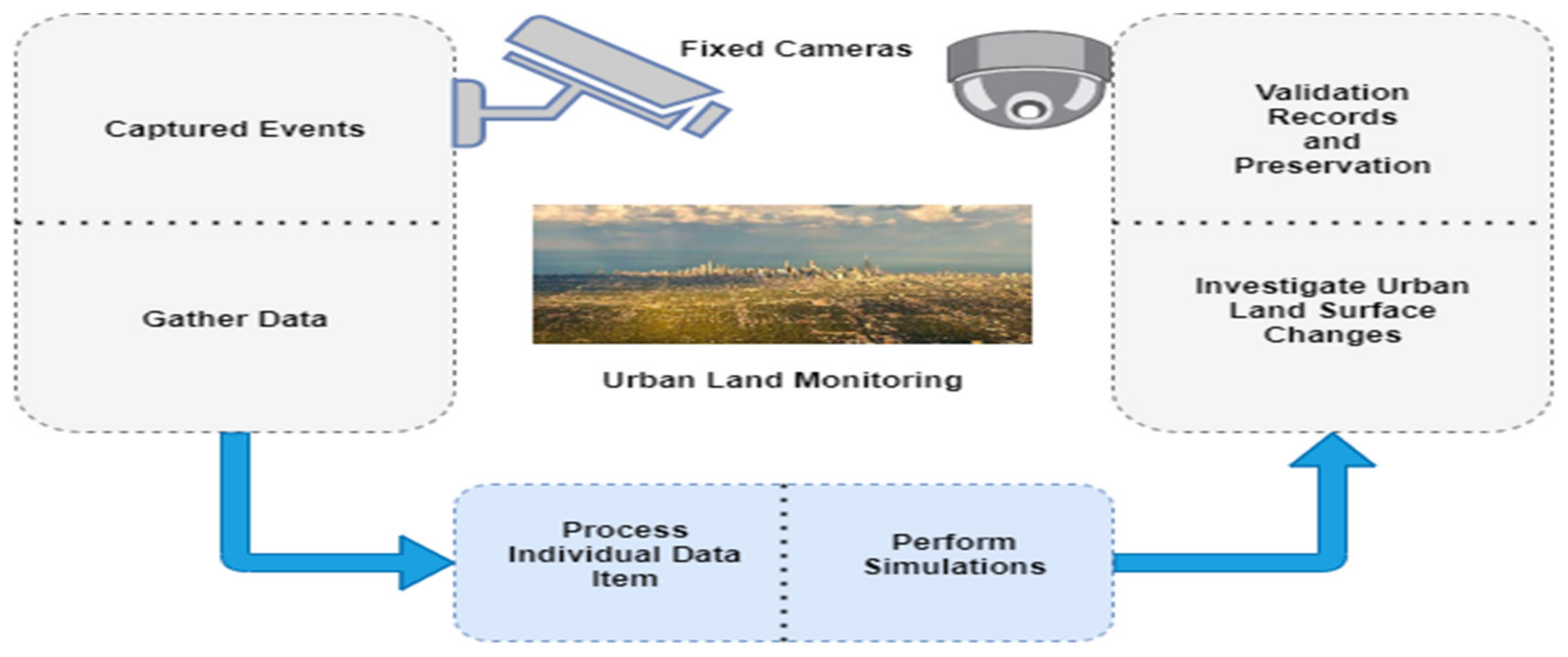
  • Day-to-day image-based data collection through drones and transmit all these records via remote sensing to the ground base-station (fog nodes)
  • Scheduling offline records
  • Scheduling online records
  • Offline management of fog enabled drone-based data management
  • Online management of fog enabled drone-based data management
In this paper, we effectively used metaheuristic algorithms like genetic algorithms to develop drone-based data management, cost optimization, and processing schedule. In this case, we design a genetic encoder that estimates cost efficiency and acts as a data scheduler. As shown in Figure 3, we can easily schedule drone-based collected data for sequential processing by tuning genes (chromosomes) and using time-space architecture. However, these are constant population and sample space lengths. Chromosomes are gene clusters. Each chromosome has its own schedule for processing data, and the size of the process is also measured.
In order to preserve processed data, the size of each chromosome varies, depending on the number of drone-based captured data generated. However, we created a function f(x) that optimises the data size (s) throughout the optimization process (p). The equation is:
f x = f s   f i
Similarly, when there is no open interval, then the equation is:
f x = f s     f i  
After tunning the intervals, compare both the equations: (i) a predefined simple genetic Equation (2), and (ii) setting the parameter of customized genetic Equation (3); where the encoder tune by = 0.011, and applied to the captured data of urban land surface changes. By applying values on the (2), we find few fluctuations in the maximum data optimization on the (2), as shown in Equations (4.1) and (4.2).
f i = e ( 0.011 sin i sin j sin 12.001 i i / 2
Then, the equation is:
f i = sin 10.1 i cos i + cos 0.5 i  
We compare Equations (1) and (2) and compute the cost of computation with the captured data, then tune the range of fog nodes that require processing (scheduler) and save the data. The analyzer calculates the dynamic processing of drone-based data, as described in Equations (4.1) and (4.2).
The genetic algorithm possesses a single interval of drone-based data for scheduled processing and management:
A list of chromosomes initiate with 0, 1, such as:
K = ( k 1 ,   k 2 ,   ,   Kn ) 2 = l = 0 a k l   2 l = s
where k is the range of chromosome (0, 1);
We take ‘N = 100′ as the size of chromosome (limit) of captured data for processing and management. Thus, with the resultant, the value of s interval change, by the equation of:
s = R H + s R G 2 N 1
where R H = shown the lower limit and R G = is the upper limit
The value of R H = 0; and R G = 1; moreover, the 16-bit interval tunned as R H = chromosome is 0000000000000000, whereas the R G = chromosome is 1111111111111111.
The dynamic monitoring and collection of images from various angles, as well as the storage of these records, have coding issues that need to be aligned. We schedule most data processing based on the chromosome’s defined limit. However, a genetic algorithm uses a tournament selection mechanism to shuffle to a chosen member in order to organize crossover. Iterations of up to 140 iterations (around 80 runs) are required to adopt the random sequence of chromosomes and mutate them to 0.010 at a maximum of 140 iterations (around 80 runs), as mentioned in Equations (7)–(9).
S i z e   o f   d a t a   o p t i m i z a t i o n = 11100111011100110101101101001001
Finally,
n l = ϵ g p ϵ
In Equation (9), ‘p’ is the customized parameter and ϵ is the change (slightly change),
s g ,   n = 1 + s ( g i n   ,     n + 1 )                         i f   g = 0 , 0                                                                                           O t h e r w i s e ,

3.2. The Proposed Blockchain-Fog-Based Data Management System Framework

This paper proposes a four-fold system framework: remote sensing devices, data investigation and schedule processing, blockchain-aware integrated environment for fog-based processing and schedule storage with robust security, and processed information and flow control (Figure 4).
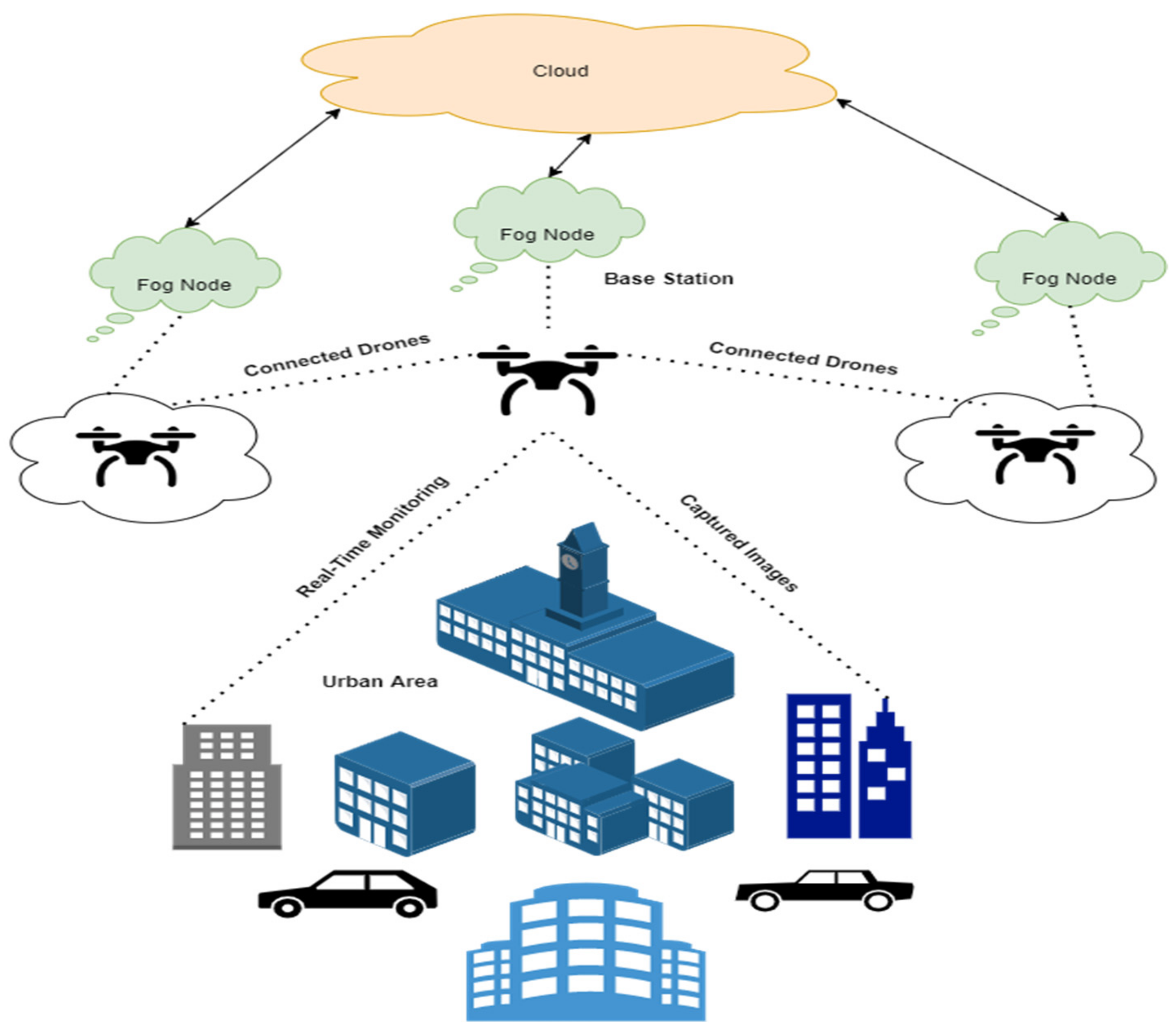
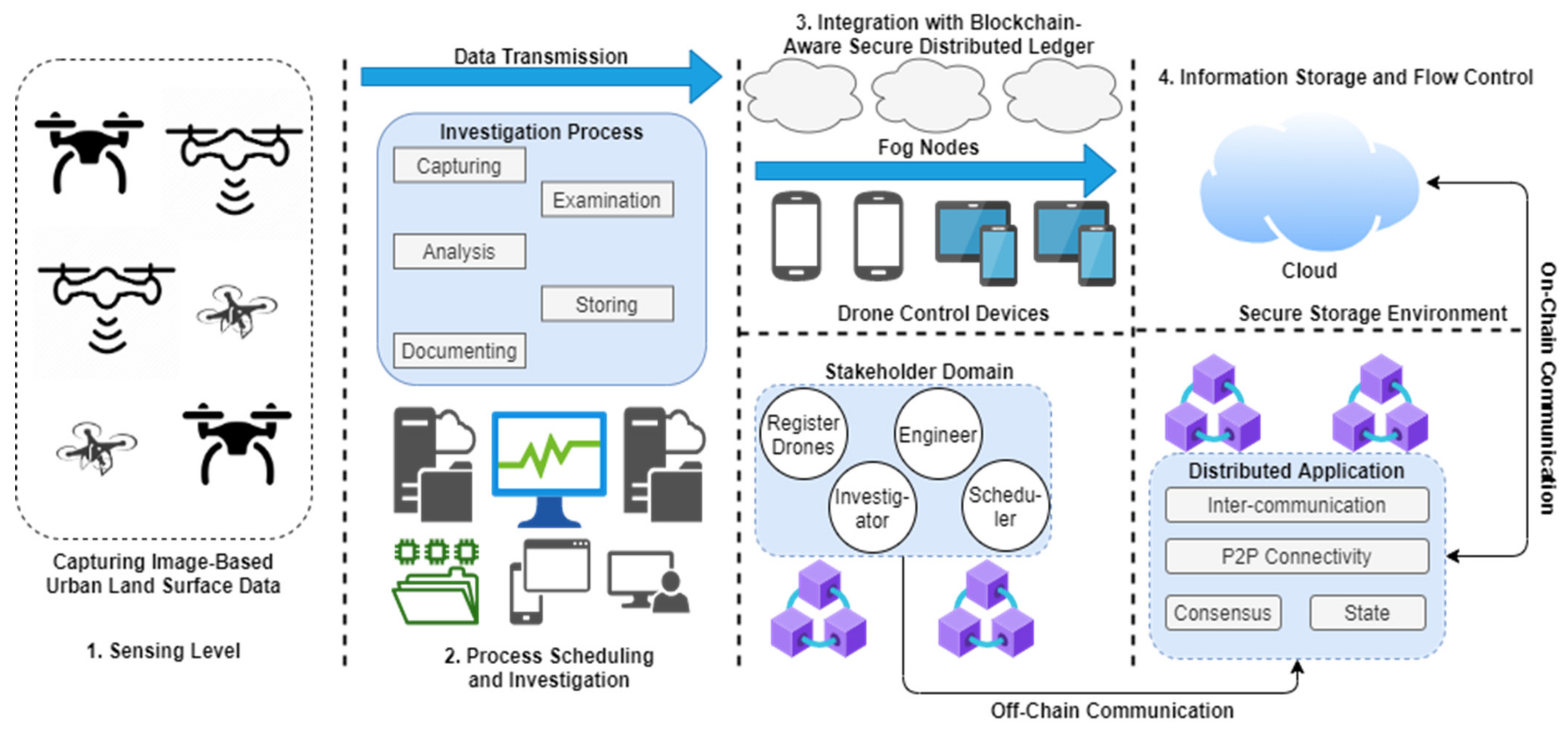
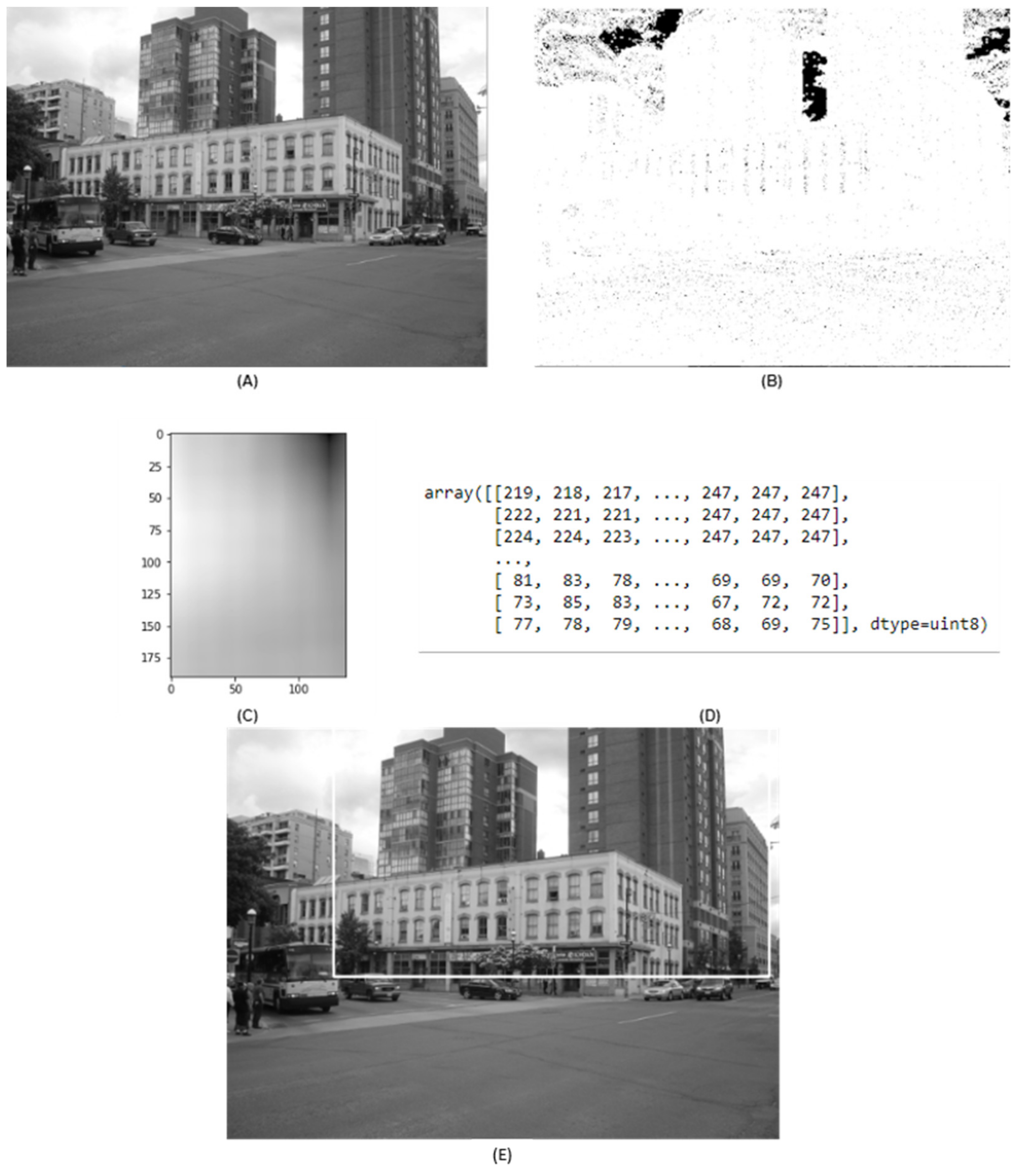
  • In the first stage, the remote sensing device is used to capture images of urban land surface changes, where various image sensors compose the critical data input source, such as the image data from drones. This captured data transmitted from the drones to the fog node framework sense the changes in urban zones for change recognition.
  • In the next stage, the sensing records from the drones are processed as a crucial step of recognition of urban land changes. These changes are analyzed as follows:
    • Capture day-to-day data
    • Schedule data in the fog node (according to the defined range)
    • In the process of data, the captured records examine and analyze the surface changes, as compared to the previous one
    • After the examination and analysis, get proper investigational reports
    • Preserve these records in cloud storage
There are distinct fog nodes utilized in this domain, where drones have embedded light-scale image cameras connected with the base station workstations that can process data locally, whereas cloud services are the final server to process change recognition.
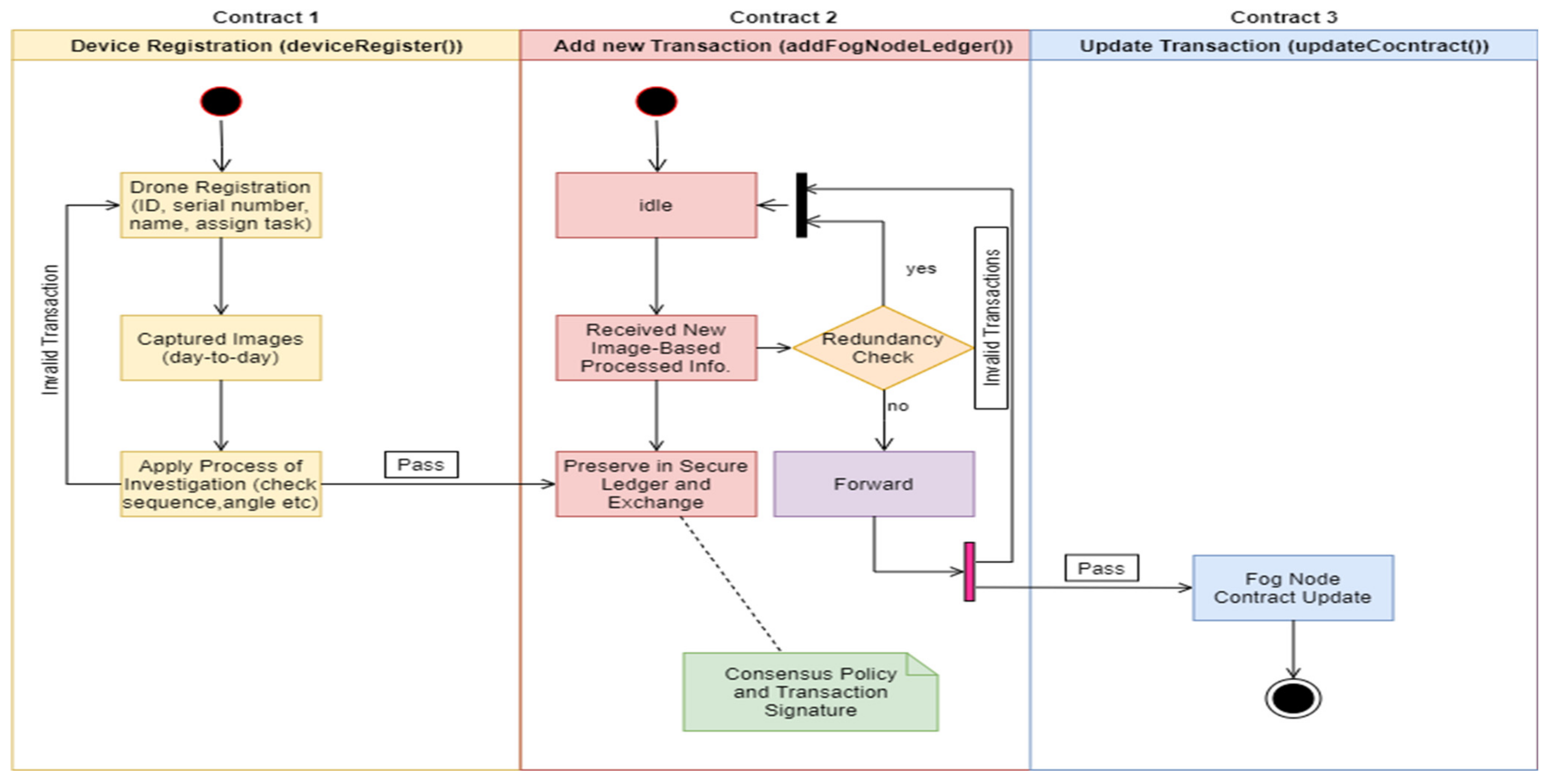
  • In the third blockchain-aware integrated secure distributed stage, the fundamental objective is to integrate all the processed information from the previous section, such as the result of urban land surface changes recognition with the help of drone-based image data. Blockchain-aware smart contract is designed and created to provide security and data management in the distributed environment; for this purpose, development of the devices registration contract is deployed for secure registration of the drone; similarly, the add node transaction contract is deployed for secure preservation of individual ledgers and updating in the cloud storage.
  • In the final stage, the cloud node is used for transmission and computing; it receives processed information and collaborates (analyzed images) to produce an exact result of urban area surface changes and for recording purposes. In this scenario, several image-based sensors collect data and transmit them to the fog node to schedule, process, and manage processed information and securely preserve them on the cloud. The network structure of this proposed system is built wirelessly, which means the complete infrastructure depends on wireless communication, as shown in Figure 4.
The proposed blockchain-aware distributed dynamic monitoring framework controls the flow of image-based data based on previous transmissions (previously recorded data control). However, this transmission only allows for one direction of data flow, making data management and security control difficult. In this way, the blockchain-aware distributed system secures the previously recorded ledger, which is the point to introduce individual tasks and their protected route. Figure 4 illustrates how the previous data flow and maintenance are determined by the fog nodes’ security and ledger privacy.

4. Proposed Blockchain-Aware Smart Contracts for Fog-Based Drone Management

In this paper, to schedule processing using a genetic algorithm and blockchain-aware management in a secure cloud system, a single type of input is used for transmitting dynamic monitoring-based captured data from drones to fog nodes.

Blockchain-Aware Smart Contracts Implementation

As shown in Contract 1 (Appendix A), initial device registration is required to tune the distributed ledger environment for blockchain-aware fog-based drone data management and process scheduling. The fog node and engineer of the system initiate and create the drone registration contract and consensus policies designed for device registration. It also records captured images of the urban land surface in accordance with the designed consensus policy, as shown in Contract 1. DroneID(), Dronename(), Droneassigntask(), DroneRoDT(), and blockchain timestamp[execute] are also recorded in the contract, as shown in Figure 5.
As a result of this, the engineer created and scheduled an automated update for the AddFogNodeLedger contract (). As well as preserving drone-based captured images of the urban land surface, this adds data to the fog node for future analysis. For example, in Contract 2, the function AddFogNodeLedger() is used to update the ledger with newly captured data (validated daily). IndividualLogID(), squareArea(), differentAngle(), investigateImage(), processAnalysis(), scheduleDataProcess(), and current blockchain timestamp[execute] are also recorded.
Upon completion of AddFogNodeLedger(), the updated drone-based transactions on the fog node are designed, created, and scheduled for an automated data update whenever new transactions occur. The contract’s updated records function (updateContract()) evaluates the newly added details and previously related fog node-related transactions information (preserve in a secure ledger). This contract also calculates the details of an updated ledger, such as accessDFP(), updateInfo(), comparePreviousRecord(), currentInfo(), blockchain timestamp[execute], and manages all addresses and addresses of all activities performed.

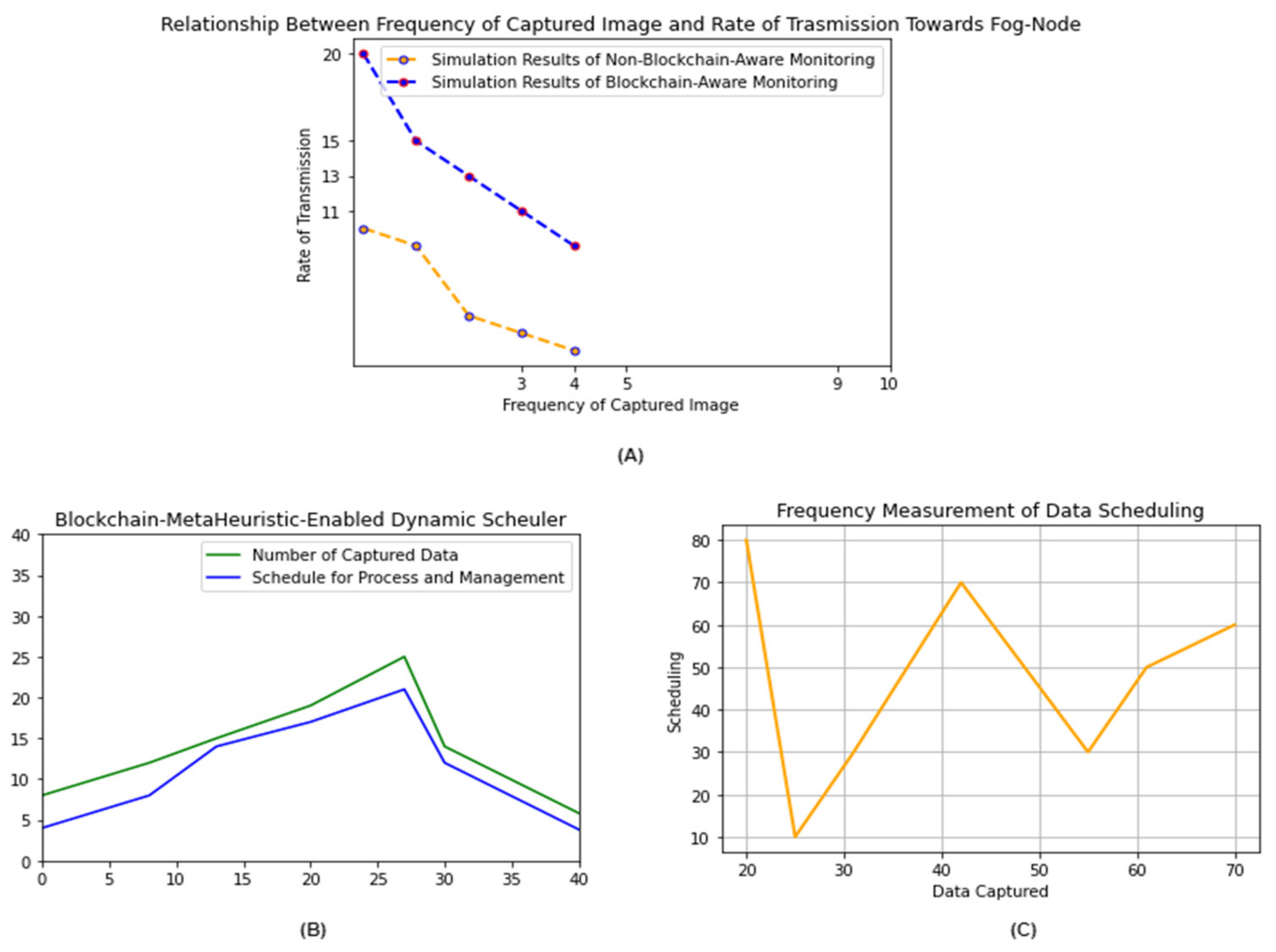
5. Results, Simulations, and Discussions

As a simulation tool, we used the York Urban Database 2021 (public repository), which is composed of 102 images divided into two categories: indoor (45) and outdoor (57). The images used in this simulation were taken with a calibrated DSLR (digital camera) [40,41]. It is a benchmark database for urban land analysis.
However, the simulation is used to examine and analyze the collected images (schedule data processing), resulting in the investigational results shown in Figure 6. In this way, the output is managed before passing through blockchain security. As shown in Figure 3 and Figure 6, the output of the process scheduling and optimization are aligned according to the process size and final scheduler individual records and management in the fog node. As shown in Figure 7, a genetic algorithm-based scheduler manages the transmitted data and is placed in accordance with the data size for processing. Using N = 0.0235, transmission power = average of −17 dBm, jitter = 30 ms, delay = average of 80 ms, throughput = 175, duty cycle = 9.2%, and dynamic response back.
To evaluate the fog-based (fog node) system, all transmitted data is first managed by a metaheuristic algorithm enabled scheduler (Figure 8). Then we compared the new records to the old ones to analyze land changes, and finally, we used blockchain distributed ledger technology to secure all new investigational records. During this step, we compare the frequency of captured images to the rate of wireless record transmission to the fog nodes. Figure 8 depicts the blockchain-aware metaheuristic (genetic algorithm) used for dynamic scheduling (defined range in Contract 2) and aligned data analysis. This aligned data gets processed, and the overall system is measured in terms of data scheduling cost and actual fluctuation in the defined analysis process, shown in Table 2. Following is a table description of some related comparisons:
The proposed system was compared to the “Design Guidelines for Blockchain-Assisted 5G-UAV Network” (M. Aloqaily et al.). The authors presented a platform that can handle high data rates and low latencies between fog nodes. The authors also discussed the importance of a blockchain-aware distributed system for UAV control to meet dynamic user demands with network access supplies [29]. We used IoT network remote sensing technology to reduce transmission costs and delays between drones and fog nodes. Blockchain-based solutions have high transaction storage costs, as well as communication and bandwidth issues. Researchers (R. Gupta et al.) discussed security-related data transmission and communication issues in “Fusion of blockchain and artificial intelligence for secure drone networking underlying 5G communications”. This paper proposed a collaborative approach using blockchain, 5G, and AI, a blockchain-enabled architecture for smart communication between drones, and AI tools and techniques [30]. Adding 5G and more computational power for AI execution reduces costs while adding blockchain storage increases costs (IPFS). In fact, we do all the processing in the fog node (and store it in the cloud), so we do not need any extra storage.
The proposed blockchain-aware system can also be easily deployed in urban zones to monitor land surface changes. Drone-based images help investigate land or climate-affected scenarios. The key benefits are dynamic data analysis in the fog, stored information with details (only critical), and sequenced records.

5.1. Challenges and Limitations

In this section, we discuss the implementation issues and challenges of the proposed blockchain-aware system and fog-based data management.

5.1.1. Fog-Based Drone Management and Data Privacy Issues

In recent years, almost every industry has adopted new technologies such as AI, IoT, 5G, edge and cloud computing, and fog. Fog computing is rapidly gaining popularity and use, filling in unknown gaps and providing better solutions [45]. The fog’s complex infrastructure allows for low latency, lower bandwidth consumption than the cloud, increased reliability and distributed operations while eliminating the need for traditional cloud connectivity. One of the concerns is the network logistics of package delivery by drones. Plans for UAV mail and product delivery are imminent [46]. Closer to the network’s edge, fog nodes can compute the determined moves of monitoring, storing, and communicating (generated data). This distributed architecture exists in a network’s layers (means network topology). Virtualization, containerization, orchestration, and efficient manageability are examples of these additional features.
Drone hub management is one of the most challenging aspects of UAVs. It is impractical for every data analyst and investigator to have an independent fleet that operates and examines the other fleet. The main goal is dynamic monitoring, which records and analyses daily changes in the land surface. For scalability, the industry should consider developing secure hub management systems for drones that can coordinate multiple flights. The use of advanced technologies to manage such hubs is critical to maintaining high-traffic drone operations and recording data from land to air. Ground-based fog-cloud controllers will schedule fog nodes and send data via sensors network. In order to maintain the ledger, the details of landing coordination, loading (capturing), uploading (transmitting), and maintenance are organized (data management).

5.1.2. Blockchain Cross-Chaining Platform Limitations

Large-scale data management-based corporations are adopting blockchain Hyperledger enabled modular solutions [44]. In this case, we find no specific and efficient protocol that achieves complete exclusivity. A cross-chaining platform is required for blockchain enabling ecosystems (interconnected). Transparency is required in the design, development, and deployment of blockchain-aware fog-cloud data management for drones [47].
The limited capacities of blockchain protocols and scalability make the system more reliable in terms of block-times and high security. Creating an interoperable solution reduces operational costs and improves performance. The lack of direct interoperability between blockchains prevents drone transactions from using a fog-cloud node within the proposed ecosystem. The techniques used to facilitate blockchain-aware serverless transactions across multiple chains without involving third parties vary. Massive industries must focus on atomic swaps, stateless SPVs, relays, merged consensus, and federations for a safe and efficient blockchain cross-chaining platform. Still, there are unresolved cross-chaining interoperable issues in the domain of fog-cloud drone-based data management and monitoring, such as trust and transaction rate bottlenecks.

5.1.3. Distributed Storage and Scalability Challenges

An important challenge in managing large-scale distributed storage systems is handling log replication and redundancy [45]. Scaling is the key to maintaining a distributed storage system and should focus on sharding and other meta storage. Thus, maintaining transparency and consistency of distributed applications during sharding is critical for a distributed storage system with elastic scaling [47,48]. Until recently, the only blockchain-aware fog-cloud-based distributed storage strategy was static data sharding. However, it is difficult to scale elastically. Sharding (key distribution and randomness) is another limitation in a blockchain distributed storage system.

5.1.4. Intercommunication Nodes Security Limitations

Blockchain is a peer-to-peer (P2P) distributed ledger technology that allows data to be preserved on different numbers of servers all over the chains, with any network of users having rights to see all the entries that appear at any time [46]. It is still a challenge to create secure fog-cloud networks and dynamic communications with distinct nodes (between drones and base stations).
The process of installing and connecting nodes takes a long time and requires a lot of expertise. Node engineers are responsible for designing nodes that store data correctly and reliably in distributed fog-cloud nodes [45,49]. In this case, each node should keep a complete and efficient copy of the distributed ledger [45,47]. Blockchain engineers must provide nodes to cloud-based service providers, small businesses, and custom engineers as a tool and service that helps them create decentralized applications faster and more securely. Thus, it reduces extra engineering time spent on node maintenance and management. Deploying intercommunication node privacy and security effectively improves information exchange in the domain of blockchain-aware distributed dynamic monitoring of urban land surface changes.

6. Conclusions

This paper discusses privacy and security issues in existing UAV data management using fog-cloud technology. The protection of urban land surface changes to dynamic distributed monitoring and investigation is one of the critical limitations. Current distributed data management and monitoring systems have limitations and gaps, such as fog-cloud node security, transaction execution, and preservation. Unified real-time distributed monitoring and data processing with blockchain is proposed. This paper also aided two different prospects, such as drone-based data capturing and fog-cloud enabled data analysis and management, and blockchain aware secure ledger preservation and communication. A metaheuristic genetic algorithm organizes data and management, collecting data for further investigation (based on defined criteria) in the fog node and storing it in the cloud.
The parameters of the fog node are initially defined while taking drone images and analyzing individual features. A detailed investigation of urban land surface changes by humans substantial includes capturing, examining, analyzing, presenting, preserving, and reporting. We designed and developed smart contracts to secure the ledger and register IoT-enabled drones (AddFogNodeLedger())—update contracts (updateContract()) and store data in immutable and distributed provenance. Deployment of a blockchain-aware dynamic distributed monitoring system deals with transaction execution, security, and privacy issues related to fog-cloud-based nodes. Moreover, the system maintains events of node transactions and provides integrity, transparency, and robust performance in data scheduling, processing, and management. The working operation of events inaction of the proposed system is represented through an activity diagram. Thus, the evaluation and explanation of the proposed system’s implementation challenges and limitations are highlighted. These emerging issues and related challenges are the primary focus of our future research.

Author Contributions

A.A.K. prepared and wrote the original draft; Z.A.S., A.A.L., S.B., and A.A.W. reviewed, rewrote, performed part of the literature survey, and edited, investigated, and designed the architecture; G.A.A.A.A. explored the software tools. All authors have read and agreed to the published version of the manuscript.

Funding

The authors would like to thank Taif University Researchers Supporting Project, TURSP-2020/26, Taif University, Taif, Saudi Arabia.

Institutional Review Board Statement

Not applicable.

Informed Consent Statement

Not applicable.

Data Availability Statement

Not applicable.

Conflicts of Interest

The authors did not have any conflict of interest.

Appendix A. Smart Contracts Implementation (Pseudocode)

Algorithm A1. Registration of Drone in Distributed Ledger Environment (deviceRegister())
Input Constraints: Blockchain-Aware Fog Node Maintenance Engineer Initiate System and Schedule Management
Data: Blockchain-Aware Fog Node Maintenance Engineer Starts Procedure of Registration and Get Applicational Request and Manages Addresses
 int main().X[file],
 drone registration ID (droneID),
 drone name;
 (dronename),
 drone assigned task;
 (droneassigntask),
 drone image capture criteria;
 (droneICC),
 drone rate of data transmission;
 (droneRoDT),
 current blockchain timestamp[execute];
 Blockchain-Aware Fog Node Maintenance Engineer handle all the request of registration and add only validated addresses on the AddFogNodeLedger() contract (afnlAddresses()),
 registered ledger on the secure base-station (groundStation());
 groundStation(),
 record counter (recordCounter());
 Blockchain-Aware Fog Node Maintenance Engineer handle the request of individual and set of registration, examine, analysis, validate, and authorized devices,
  Also,
 Blockchain Engineer responsible for the maintenance of registered ledger and addresses in the smart contract;
If int main().X[file] = true
then if check drone registration ID is in the registration contract = true
  then change the state of the ledger and add a new device with details and addresses
  additionally, record more details for the protected ledger,
  droneID(), dronename(), droneassigntask(), droneICC(), droneRoDT(), and blockchain timestamp[execute];also, record afnlAddresses();
else
  record, maintain state, check error generation, and rollback,
  stop;
else
  record, maintain state, check error generation, and rollback,
  stop;
Algorithm A2. Add Drone-based Captured Image Data in the Distributed Fog Node and Schedule Data Process Management of Urban Land Surface Changes (AddFogNodeLedger())
Input Constraints: Blockchain-Aware Fog Node Maintenance Engineer Initiate System and Schedule Management
Data: Blockchain-Aware Fog Node Maintenance Engineer Starts Procedure of Registration and Get Applicational Request and Manages Addresses
 int main().X[file],
 individual log ID (individualLogID),
 area of urban land;
  (squareArea),
 image captured angle;
 (differentAngle),investigate each image aspects;
 (investigateImage),
 investigation process analysis;
 (processAnalysis),
 schedule data process;
 (scheduleDataProcess),
 current blockchain timestamp[execute];
 Blockchain-Aware Fog Node Maintenance Engineer Initiate Add() contract,
  Engineer manage Add() contract and count (counter())
 Blockchain Engineer manage the request of individual and set of Add() new drone-based captured image, examine, analysis, validate, and authorized system,
If int main().X[file] = true;
then if check duplication and add day-to-day new image-based data in the ledger,
  then change the state of the ledger and add new image-based records with detailed descriptions and addresses
  additionally, record more details of urban land surface changes in the AddFogNodeLedger()
  individualLogID(), squareArea(), differentAngle(), investigateImage(), processAnalysis(), scheduleDataProcess(), and current blockchain timestamp[execute];
  finally, add update details on updateContract()to the distributed ledger,
  counter + 1;
else
 record, maintain state, check error generation, and roll back,
 stop;
else
 record, maintain state, check error generation, and rollback,
 stop;
Algorithm A3. After Investigational Process and Analysis of Drone-Based Captured Image Records and Preserve this Processed Information in the Blockchain Distributed Storage (updateContract())
Input Constraints: Blockchain-Aware Fog Node Maintenance Engineer Initiate System and Schedule Management
Data: Blockchain-Aware Fog Node Maintenance Engineer Starts Procedure of Registration and Get Applicational Request and Manages Addresses
 int main().X[file],
 access data for processing (accessDFP),
 update information;
 (updateInfo),
 compare the previous record;
 (comparePreviousRecord),
 current information;
 (currentInfo),blockchain timestamp[execute];
 Blockchain-Aware Fog Node Maintenance Engineer manage all the request of individual and set of Update() new analyzed information, validates, preserves, authorizes, and addresses,
 Also,
 Blockchain Engineer responsible for the manage update ledger and addresses in the contract;
If int main().X[file] = true;
then if check previous added ledger = value (true);
then, change the state of the ledger and update new analyzed information with details description and addresses
  and,
  updateContract(),
  additionally, record more details,
  accessDFP(), updateInfo(), comparePreviousRecord(), currentInfo(), and blockchain timestamp[execute];
  updateContract() = counter + 1;
else
  record, maintain state, check error generation, and rollback,
  stop;
else
  record, maintain state, check error generation, and rollback,
   stop;

References

  1. Zhang, G.; Xu, B.; Liu, E.; Xu, L.; Zheng, L. Task placement for crowd recognition in edge-cloud based urban intelligent video systems. Clust. Comput. 2021, 1–14. [Google Scholar] [CrossRef]
  2. Lv, L.; Yang, Z.; Zhang, L.; Huang, Q.; Tian, Z. Multi-party transaction framework for drone services based on alliance blockchain in smart cities. J. Inf. Secur. Appl. 2021, 58, 102792. [Google Scholar] [CrossRef]
  3. Hassan, H.; El-Desouky, A.I.; Ibrahim, A.; El-Kenawy, E.-S.M.; Arnous, R. Enhanced QoS-Based Model for Trust Assessment in Cloud Computing Environment. IEEE Access 2020, 8, 43752–43763. [Google Scholar] [CrossRef]
  4. Tange, K.; De Donno, M.; Fafoutis, X.; Dragoni, N. A Systematic Survey of Industrial Internet of Things Security: Requirements and Fog Computing Opportunities. IEEE Commun. Surv. Tutor. 2020, 22, 2489–2520. [Google Scholar] [CrossRef]
  5. Mahmud, R.; Ramamohanarao, K.; Buyya, R. Application management in fog computing environments: A taxonomy, review and future directions. ACM Comput. Surv. (CSUR) 2020, 53, 1–43. [Google Scholar] [CrossRef]
  6. Khan, A.; Laghari, A.; Awan, S. Machine Learning in Computer Vision: A Review. Scal. Inf. Syst. 2021. [Google Scholar] [CrossRef]
  7. Peleshko, D.; Rak, T.; Noennig, J.R.; Lytvyn, V.; Vysotska, V. Drone Monitoring System DROMOS of Urban Environmental Dynamics; ITPM: Chiyoda, Tokyo, 2020; pp. 178–193. [Google Scholar]
  8. Dutta, P.K.; Mitra, S. Application of Agricultural Drones and IoT to Understand Food Supply Chain During Post COVID-19. In Agricultural Informatics: Automation Using the IoT and Machine Learning; Wiley: Hoboken, NJ, USA, 2021; pp. 67–87. [Google Scholar]
  9. Voloshyn, V. Conceptual Model of Information System for Drone Monitoring of Trees’ Condition; CEUR: Aachen, Germany, 2020; pp. 695–714. [Google Scholar]
  10. Khan, A.A.; Shaikh, A.A.; Cheikhrouhou, O.; Laghari, A.A.; Rashid, M.; Shafiq, M.; Hamam, H. IMG-forensics: Multimedia-enabled information hiding investigation using convolutional neural network. IET Image Process. 2021. [Google Scholar] [CrossRef]
  11. Lianbing, D.; Daming, L.; Zhiming, C. Emergency management system of urban waterlogging based on cloud computing platform and 3D visualization. J. Intell. Fuzzy Syst. 2020, 39, 5595–5608. [Google Scholar] [CrossRef]
  12. Brunton, E.A.; Leon, J.X.; Burnett, S.E. Evaluating the Efficacy and Optimal Deployment of Thermal Infrared and True-Colour Imaging When Using Drones for Monitoring Kangaroos. Drones 2020, 4, 20. [Google Scholar] [CrossRef]
  13. Jin, Y.; Qian, Z.; Gong, S.; Yang, W. Learning Transferable Driven and Drone Assisted Sustainable and Robust Regional Disease Surveillance for Smart Healthcare. IEEE/ACM Trans. Comput. Biol. Bioinform. 2020, 18, 114–125. [Google Scholar] [CrossRef] [PubMed]
  14. Khan, A.A.; Laghari, A.A.; Awan, S.; Jumani, A.K. Fourth Industrial Revolution Application: Network Forensics Cloud Security Issues. In Security Issues and Privacy Concerns in Industry 4.0 Applications; Wiley: Hoboken, NJ, USA, 2021; pp. 15–33. [Google Scholar]
  15. Loke, S.W.; Rakotonirainy, A. Automated Vehicles, Urban Robots and Drones: Three Elements of the Automated City. In The Automated City; Springer: Cham, Switzerland, 2021; pp. 69–108. [Google Scholar]
  16. Laghari, A.A.; Wu, K.; Laghari, R.A.; Ali, M.; Khan, A.A. A Review and State of Art of Internet of Things (IoT). Arch. Comput. Methods Eng. 2021, 1–19. [Google Scholar] [CrossRef]
  17. Kim, B.; Jung, J.; Min, H.; Heo, J. Energy Efficient and Real-Time Remote Sensing in AI-Powered Drone. Mob. Inf. Syst. 2021, 2021, 6650053. [Google Scholar] [CrossRef]
  18. Hannan, A.; Hussain, F.; Ali, N.; Ehatisham-Ul-Haq, M.; Ashraf, M.U.; Alghamdi, A.M.; Alfakeeh, A.S. A decentralized hybrid computing consumer authentication framework for a reliable drone delivery as a service. PLoS ONE 2021, 16, e0250737. [Google Scholar] [CrossRef]
  19. Frouin-Mouy, H.; Tenorio-Hallé, L.; Thode, A.; Swartz, S.; Urbán, J. Using two drones to simultaneously monitor visual and acoustic behaviour of gray whales (Eschrichtius robustus) in Baja California, Mexico. J. Exp. Mar. Biol. Ecol. 2020, 525, 151321. [Google Scholar] [CrossRef]
  20. Merkert, R.; Bushell, J. Managing the drone revolution: A systematic literature review into the current use of airborne drones and future strategic directions for their effective control. J. Air Transp. Manag. 2020, 89, 101929. [Google Scholar] [CrossRef] [PubMed]
  21. Kelm, K.; Antos, S.; McLaren, R. Applying the FFP Approach to Wider Land Management Functions. Land 2021, 10, 723. [Google Scholar] [CrossRef]
  22. Spanaki, K.; Karafili, E.; Sivarajah, U.; Despoudi, S.; Irani, Z. Artificial intelligence and food security: Swarm intelligence of AgriTech drones for smart AgriFood operations. Prod. Plan. Control. 2021, 1–19. [Google Scholar] [CrossRef]
  23. Jin, Y.; Xu, J.; Wu, S.; Xu, L.; Yang, D.; Xia, K. Bus network assisted drone scheduling for sustainable charging of wireless rechargeable sensor network. J. Syst. Arch. 2021, 116, 102059. [Google Scholar] [CrossRef]
  24. Shahmoradi, J.; Talebi, E.; Roghanchi, P.; Hassanalian, M. A Comprehensive Review of Applications of Drone Technology in the Mining Industry. Drones 2020, 4, 34. [Google Scholar] [CrossRef]
  25. Kannan, R.J.; Yadav, K.P. Drone Routing Techniques for Surveying in Urban Areas. Rev. Int. Geogr. Educ. Online 2021, 11, 4157–4167. [Google Scholar]
  26. How Jin Aik, D.; Ismail, M.H.; Muharam, F.M. Land use/land cover changes and the relationship with land surface temperature using Landsat and MODIS imageries in Cameron Highlands, Malaysia. Land 2020, 9, 372. [Google Scholar] [CrossRef]
  27. Abir, F.A.; Saha, R. Assessment of land surface temperature and land cover variability during winter: A spatio-temporal analysis of Pabna municipality in Bangladesh. Environ. Chall. 2021, 4, 100167. [Google Scholar] [CrossRef]
  28. Sajib, Q.U.; Wang, T. Estimation of Land Surface Temperature in an Agricultural Region of Bangladesh from Landsat 8: Intercomparison of Four Algorithms. Sensors 2020, 20, 1778. [Google Scholar] [CrossRef] [Green Version]
  29. Tan, Z.; Qu, H.; Zhao, J.; Zhou, S.; Wang, W. UAV-Aided Edge/Fog Computing in Smart IoT Community for Social Augmented Reality. IEEE Internet Things J. 2020, 7, 4872–4884. [Google Scholar] [CrossRef]
  30. Khan, A.A.; Laghari, A.A.; Liu, D.-S.; Shaikh, A.A.; Ma, D.-D.; Wang, C.-Y.; Wagan, A.A. EPS-Ledger: Blockchain Hyperledger Sawtooth-Enabled Distributed Power Systems Chain of Operation and Control Node Privacy and Security. Electronics 2021, 10, 2395. [Google Scholar] [CrossRef]
  31. Huang, X.; Yang, X.; Chen, Q.; Zhang, J. Task Offloading Optimization for UAV-assisted Fog-enabled Internet of Things Networks. IEEE Internet Things J. 2021. [Google Scholar] [CrossRef]
  32. Luo, Y.; Hu, Q.; Wang, Y.; Wang, J.; Alfarraj, O.; Tolba, A. Revenue Optimization of a UAV-Fog Collaborative Framework for Remote Data Collection Services. IEEE Access 2020, 8, 150599–150610. [Google Scholar] [CrossRef]
  33. Li, X.; Zhou, L.; Sun, Y.; Ulziinyam, B. Multi-task offloading scheme for UAV-enabled fog computing networks. EURASIP J. Wirel. Commun. Netw. 2020, 2020, 230. [Google Scholar] [CrossRef]
  34. Chen, Z.; Xiao, N.; Han, D. A Multilevel Mobile Fog Computing Offloading Model Based on UAV-Assisted and Heterogeneous Network. Wirel. Commun. Mob. Comput. 2020, 2020, 8833722. [Google Scholar] [CrossRef]
  35. Liu, X.; Lai, B.; Gou, L.; Lin, C.; Zhou, M. Joint Resource Optimization for UAV-Enabled Multichannel Internet of Things Based on Intelligent Fog Computing. IEEE Trans. Netw. Sci. Eng. 2020. [Google Scholar] [CrossRef]
  36. Munir, A.; Kwon, J.; Lee, J.H.; Kong, J.; Blasch, E.; Aved, A.J.; Muhammad, K. FogSurv: A Fog-Assisted Architecture for Urban Surveillance Using Artificial Intelligence and Data Fusion. IEEE Access 2021, 9, 111938–111959. [Google Scholar] [CrossRef]
  37. Kanchi, S.; Prasad, R.V. Integral Framework for UAV: Navigational and Wireless Connectivity Aspects. In Proceedings of the 2021 IEEE Region 10 Symposium (TENSYMP), Jeju, Korea, 23–25 August 2021; pp. 1–6. [Google Scholar]
  38. Gao, Q.; Shen, X.; Niu, W. Large-Scale Synthetic Urban Dataset for Aerial Scene Understanding. IEEE Access 2020, 8, 42131–42140. [Google Scholar] [CrossRef]
  39. Chodorek, A.; Chodorek, R.R.; Sitek, P. UAV-Based and WebRTC-Based Open Universal Framework to Monitor Urban and Industrial Areas. Sensors 2021, 21, 4061. [Google Scholar] [CrossRef]
  40. Lee, S.J.; Hwang, S.S. Fast and Accurate Self-calibration Using Vanishing Point Detection in Manmade Environments. Int. J. Control. Autom. Syst. 2020, 18, 2609–2620. [Google Scholar] [CrossRef]
  41. López-Martinez, A.; Cuevas, F.J. Vanishing point detection using the teaching learning-based optimisation algorithm. IET Image Process. 2020, 14, 2487–2494. [Google Scholar] [CrossRef]
  42. Allouch, A.; Cheikhrouhou, O.; Koubâa, A.; Toumi, K.; Khalgui, M.; Gia, T.N. UTM-Chain: Blockchain-Based Secure Unmanned Traffic Management for Internet of Drones. Sensors 2021, 21, 3049. [Google Scholar] [CrossRef]
  43. Bartolini, N.; Coletta, A.; Maselli, G.; Piva, M. DRUBER: A trustable decentralized drone-based delivery system. In Proceedings of the 6th ACM Workshop on Micro Aerial Vehicle Networks, Systems, and Applications, Toronto, ON, Canada, 15 June 2020; pp. 1–6. [Google Scholar]
  44. Aggarwal, S.; Kumar, N.; Tanwar, S. Blockchain-Envisioned UAV Communication Using 6G Networks: Open Issues, Use Cases, and Future Directions. IEEE Internet Things J. 2021, 8, 5416–5441. [Google Scholar] [CrossRef]
  45. Aleisa, M.A.; Abuhussein, A.; Sheldon, F.T. Access Control in Fog Computing: Challenges and Research Agenda. IEEE Access 2020, 8, 83986–83999. [Google Scholar] [CrossRef]
  46. Khan, A.A.; Uddin, M.; Shaikh, A.A.; Laghari, A.A.; Rajput, A.E. MF-Ledger: Blockchain Hyperledger Sawtooth-Enabled Novel and Secure Multimedia Chain of Custody Forensic Investigation Architecture. IEEE Access 2021, 9, 103637–103650. [Google Scholar] [CrossRef]
  47. Ashi, Z.; Al-Fawa’Reh, M.; Al-Fayoumi, M. Fog Computing: Security Challenges and Countermeasures. Int. J. Comput. Appl. 2020, 175, 30–36. [Google Scholar] [CrossRef]
  48. Aloqaily, M.; Bouachir, O.; Boukerche, A.; Al Ridhawi, I. Design Guidelines for Blockchain-Assisted 5G-UAV Networks. IEEE Netw. 2021, 35, 64–71. [Google Scholar] [CrossRef]
  49. Gupta, R.; Kumari, A.; Tanwar, S. Fusion of blockchain and artificial intelligence for secure drone networking underlying 5G communications. Trans. Emerg. Telecommun. Technol. 2021, 32, 4176. [Google Scholar] [CrossRef]
Figure 1. Existing Process of Urban Land Surface Monitoring Investigation.
Atmosphere 12 01525 g001
Figure 2. Current Scenario of Fog-Cloud Node Data Management and Processing.
Atmosphere 12 01525 g002
Figure 3. Process Distribution and Management.
Atmosphere 12 01525 g003
Figure 4. The Proposed Blockchain-Aware Distributed Dynamic Monitoring and Fog-based Data Processing and Management Framework.
Atmosphere 12 01525 g004
Figure 5. Events of Fog Node Transaction Execution.
Atmosphere 12 01525 g005
Figure 6. Simulation Results of the Proposed Blockchain-Aware Framework for Distributed Monitoring. (A) is the Input Image in the Form of Black and White, (B) is the Encoded Image, (C) is the Threshold, (D) is the Image Matrix, and (E) is the Output in the Form of Urban Land Surface Analysis.
Atmosphere 12 01525 g006
Figure 7. Analysis of Captured Image and Transmission Cost. (A) is the Frequency Analysis of Captured Image in Terms of Urban Land Changes Recognition and the Area of Fluctuation, and (B) is the Captured Image Transmission Wirelessly.
Atmosphere 12 01525 g007
Figure 8. Fog-Based System Evaluation. (A) is the Relationship Between the Frequency of Captured Image and the Rate of Transmission Towards Fog Node, and (B) is the Blockchain-MetaHeuristic (Genetic Algorithm) Enabled Dynamic Scheduler Analysis and Align for Processing, and (C) is the Measurement of Frequency of Data Scheduling and Analysis the Actual Fluctuation.
Atmosphere 12 01525 g008
Table 1. Land Surface Changes and Fog-Cloud Computing-Related Literature.
Research TitleMethodology/TechniqueChallenges/LimitationsDifferences/SimilaritiesReferences
A decentralized hybrid computing consumer authentication framework for a reliable drone delivery as a serviceA consumer authentication hybrid computing framework for UAVs as a service was proposed. This framework allows a UAV to use a GPS to navigate to its destination and deliver packages to the intended consumer.
  • High delay in data transmission between drone to a base station
  • More storage required
  • One-time password verification
  • Two-factor consumer authentication
  • There is no automated execution with a secure ledger-based smart contract implementation structure
[18]
Using two drones to simultaneously monitor the visual and acoustic behaviour of Gray Whales (Eschrichtius robustus) in Baja California, MexicoH. F. Mouy et al. discussed a short communication based on two UAVs: first to obtain acoustic measurement close to the whales, and the second to obtain overhead visual behaviour observation.
  • No smart contract used
  • Limited cloud-based data processing and management
  • Monitoring strategy design only for Eschrichtius robustus
  • This architecture is designed for the drone-based monitor visual and acoustic behaviour of Gray Whales in Mexico
  • Moreover, this study did not propose or create any secure ledger mechanism
[19]
Managing the drone revolution: A systematic literature review into the current use of airborne drones and future strategic directions for their effective controlThe authors of this study explained the need for more policy and its implementation with management response. To maintain efficient drone usage with a promising strategic response that is low altitude airspace management.
  • Drone-based image recreation problem
  • Image-based data transmission and collection issue
  • Effective monitoring but fixed camera placement limitation
  • Data processing of drone-based management bottleneck
  • There is no proper implementation available in this research
[20]
Applying the FFP Approach to Wider LandManagement FunctionsThis paper addressed the importance of global security of tenure divide and the implementation of fit-for-purpose land administration method. An examination process for a common set of captured data strategies and exchanged geospatial data was proposed in this study.
  • Visualization of data (quality)
  • Urban digital twins
  • Issues in master planning and strategy
  • No connectivity between other fit-for-purpose land management function
  • Data compliance challenge
  • Artificial Intelligence and machine learning algorithms used to create the fit-for-purpose administrative application to wider land management functions
[21]
Artificial Intelligence and Food Security: Swarm Intelligence of AgriTech Drones for Smart AgriFood OperationsThe study proposed an adoptive design using artificial intelligence (swam intelligence) to identify and analyse food security issues (namely AgriTech). Drones improved farming productivity in inaccessible land by supporting inaccessible farming operations (AgriFood).
  • The economics of digital farming is still the challenging area
  • Boarder tendency
  • Cover farm size with a single drone
  • Not for small-scale farming
  • The implementation of this is limited because of land restriction (it is for rural only).
  • Limitation in the form of large-scale farming and monitoring
  • Less ledger security
  • Drone management strategy is good but limited scope of land surface changes analysis
[22]
Bus Network Assisted Drone Scheduling for Sustainable Charging of Wireless Rechargeable Sensor NetworkThis paper formulated the drone scheduling problem based on the new wireless charging mechanism to reduce the cost and time of the drone (during flight) subject to all integrated wireless sensors that can be charged under the constraint of energy in this drone system.
  • The sustainable energy for sensor development in urban land
  • Only compared with the greedy replenished energy algorithm (single state-of-the-art algorithm)
  • Less security
  • High transmission delay
  • Drone scheduling with a bus network
  • Deadline drone scheduling
[23]
A Comprehensive Review of Applications of Drone Technology in the Mining IndustryThis paper discussed the current state of drone technology and its application in urban land, especially mining. The comparison is based on routine drone operations like 3D mapping, ore control, land fragmentation measurement, etc.
  • Drone configuration and management issue
  • More energy consumption (hovering)
  • Wireless connectivity issue with base-station and image processing issue
  • Less drone-based ledger security
  • Remote sensing
  • Land surface mining
  • Abandoned and underground mining applications discussed
  • Both 2D and 3D view presentation
[24]
Drone Routing Techniques for Surveying in Urban AreasThe authors used UAVs to quickly identify outdoor properties that would be difficult to mark through the land in this paper. As well as UAV routing and processing flexibility. An evolutionary neural network with augmenting topology was used.
  • Drone history of reconfiguration
  • Modulation
  • High delay
  • Reduce transmission cost but increase energy consumption
  • Connective threshold issue
  • Centralized system with less security
  • No ledger privacy and protection mechanism used
  • More bandwidth required
[25]
Table 2. Comparison with State-of-the-Art Methods.
Research MethodResearch DescriptionComparison with Respect to Our Proposed SystemReferences
UTM-chain: blockchain-based secure unmanned traffic management for internet of dronesThe authors of this paper proposed a solution to the security issue for UAV-enabled data traffic management (DTM):
  • A lightweight blockchain Hyperledger fabric-based data traffic management and monitoring system created
  • Only focused on a single aspect, which is drone-based data handling and preservation with security
In our system, the blockchain consortium network communication allows on-chain and off-chain data traffic management, handling, and tackling (scheduled processes). Thus, it does not require additional storage or security features such as ledger registration and integrity, transparency, system provenance, trustworthiness, maintainability, and availability.[42]
DRUBER: a trustable decentralized drone-based delivery systemThis paper proposed a fully decentralized distributed service based on a fleet of coordinated UAVs owned by various stakeholders. In [43], the proposed system is used for parcel handovers and battery swaps.Unlike this mechanism, we designed and deployed blockchain smart contracts. An automated system that collects valid data and validates it with a blockchain-savvy engineer. The device (drone) then does its job (exchanges data) as specified in the criteria (discussed working operation in the implementation of smart contracts).[43]
Blockchain-Envisioned UAV Communication Using 6G Networks: Open Issues, Use Cases, and Future DirectionsThe valuable contribution in the domain of UAVs and their communication channel for secure node transactions in the network. Various aspects are used to secure drone-based transactions, including
  • Blockchain-envisioned security solution
  • 6G-enabled network connectivity
  • And collaborate with industry 4.0 applications
Our proposed system uses smart contracts to schedule, process, and manage drone data in urban land surface changes. Following are some major calculative differences for secure drone-based transactions:
  • Peer-to-peer (P2P) network
  • Hash encryption (SH-256)
  • Blockchain-aware security solution
  • Permissioned network
  • A major role of blockchain engineer for the process of verification and validation
[44]
Publisher’s Note: MDPI stays neutral with regard to jurisdictional claims in published maps and institutional affiliations.

