Next Issue
Volume 12, May
Previous Issue
Volume 12, March


Water, Volume 12, Issue 4 (April 2020) – 298 articles

Cover Story (view full-size image): 
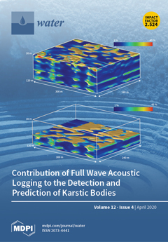
Geophysical investigations of the near subsurface are increasingly appealing to the Hydrological community, mainly for their ability to image under-sampled systems usually only visible via wells. The feature is here exemplified by high-resolution seismic data able to probe local variations in compression-wave propagation velocities. If these velocities are processed to transform them into pseudo-porosity values, seismic data image the widespread but discontinuous water bearing bodies of a karstified limestone aquifer (see associated Figure, with 3 layers of high porosity levels). For seeking very small karstic features, crosscut by wells, acoustic logs also valuably complement seismic data. View this paper.
  • Issues are regarded as officially published after their release is announced to the table of contents alert mailing list.
  • You may sign up for e-mail alerts to receive table of contents of newly released issues.
  • PDF is the official format for papers published in both, html and pdf forms. To view the papers in pdf format, click on the "PDF Full-text" link, and use the free Adobe Reader to open them.
Order results
Result details
Section
Select all
Export citation of selected articles as:
2 pages, 160 KiB  
Correction
Correction: Kamruzzaman, M., et al. Evaluating the Impact of Climate Change on Paddy Water Balance Using APEX-Paddy Model. Water 2020, 12, 852
by Mohammad Kamruzzaman, Syewoon Hwang, Soon-Kun Choi, Jaepil Cho, Inhong Song, Jung-Hun Song, Hanseok Jeong, Taeil Jang and Seung-Hwan Yoo
Water 2020, 12(4), 1221; https://0-doi-org.brum.beds.ac.uk/10.3390/w12041221 - 24 Apr 2020
Viewed by 1907
Abstract
The authors wish to make the following corrections to this paper [...] Full article
17 pages, 4109 KiB  
Article
The Costs of Sea-Level Rise: Coastal Adaptation Investments vs. Inaction in Iberian Coastal Cities
by Luis Maria Abadie, Elisa Sainz de Murieta and Ibon Galarraga
Water 2020, 12(4), 1220; https://0-doi-org.brum.beds.ac.uk/10.3390/w12041220 - 24 Apr 2020
Cited by 13 | Viewed by 4139
Abstract
Iberian coastal cities are subject to significant risks in the next decades due to climate change-induced sea-level rise. These risks are quite uncertain depending on several factors. In this article, we estimate potential economic damage in 62 Iberian coastal cities from 2020 to [...] Read more.
Iberian coastal cities are subject to significant risks in the next decades due to climate change-induced sea-level rise. These risks are quite uncertain depending on several factors. In this article, we estimate potential economic damage in 62 Iberian coastal cities from 2020 to 2100 using regional relative sea-level rise data under three representative concentration pathways (RCP 8.5, RCP 4.5 and RCP 2.6). We analyze the expected accumulated damage costs if no adaptation actions take place and compare this scenario to the investment cost of some adaptation strategies being implemented. The results show that some adaptation strategies are less costly than the potential damage under inaction. In other words, it is economically rational to invest in adaptation even in a context of high uncertainty. These calculations are very relevant to inform climate change adaptation decisions and to better manage the risk posed by sea-level rise. Moreover, our findings show the importance of a good understanding of the shape of the sea-level rise and damage cost distributions to calculate the expected damage. We show that using the 50th percentile for these calculations is not adequate as it leads to a serious underestimation of expected damage and coastal risk. Full article
(This article belongs to the Special Issue Relative Sea-Level Changes and their Impact on Coastal Zones)
Show Figures

Figure 1

10 pages, 1831 KiB  
Article
What Is the Minimum Volume of Sample to Find Small Microplastics: Laboratory Experiments and Sampling of Aveiro Lagoon and Vouga River, Portugal
by Joana C. Prata, Maria J. Manana, João P. da Costa, Armando C. Duarte and Teresa Rocha-Santos
Water 2020, 12(4), 1219; https://0-doi-org.brum.beds.ac.uk/10.3390/w12041219 - 24 Apr 2020
Cited by 23 | Viewed by 6315
Abstract
Small microplastics (<1 mm) comprise a great fraction of microplastics (<5 mm) found in the environment and are often overlooked due to the constrains of transporting and filtering large volumes of water in grab samplings. The objective of this work was to determine [...] Read more.
Small microplastics (<1 mm) comprise a great fraction of microplastics (<5 mm) found in the environment and are often overlooked due to the constrains of transporting and filtering large volumes of water in grab samplings. The objective of this work was to determine the minimum volume for reliable quantification of small microplastics in the environment. Different volumes (0.1, 0.25, 0.5, 1, 2.5 L) of laboratory spikes (fresh and saltwater) and environmental samples were filtered. Sampling volumes of 0.5 L or 1 L are a good compromise between drawbacks, such as effort, time, organic and mineral matter, potential contamination, and reliability of results, evaluated by interquartile range, accuracy, coefficient of variation, and recovery rates. Moreover, the observation of Nile Red-stained environmental samples under 470 nm produced six-times higher concentrations than samples under 254 nm, namely, 18 microplastics L−1 and 3 microplastics L−1 for the Aveiro Lagoon and 1 microplastics L−1 and 0 microplastics L−1 for the Vouga River, Portugal. This work also raises concerns about the underreporting of environmental concentrations of microplastics. Full article
(This article belongs to the Special Issue Microplastics in Aquatic Environments and Wastewater Treatment )
Show Figures

Figure 1

17 pages, 2182 KiB  
Review
A Review on Hydrodynamics of Free Surface Flows in Emergent Vegetated Channels
by Soumen Maji, Prashanth Reddy Hanmaiahgari, Ram Balachandar, Jaan H. Pu, Ana M. Ricardo and Rui M.L. Ferreira
Water 2020, 12(4), 1218; https://0-doi-org.brum.beds.ac.uk/10.3390/w12041218 - 24 Apr 2020
Cited by 28 | Viewed by 5316
Abstract
This review paper addresses the structure of the mean flow and key turbulence quantities in free-surface flows with emergent vegetation. Emergent vegetation in open channel flow affects turbulence, flow patterns, flow resistance, sediment transport, and morphological changes. The last 15 years have witnessed [...] Read more.
This review paper addresses the structure of the mean flow and key turbulence quantities in free-surface flows with emergent vegetation. Emergent vegetation in open channel flow affects turbulence, flow patterns, flow resistance, sediment transport, and morphological changes. The last 15 years have witnessed significant advances in field, laboratory, and numerical investigations of turbulent flows within reaches of different types of emergent vegetation, such as rigid stems, flexible stems, with foliage or without foliage, and combinations of these. The influence of stem diameter, volume fraction, frontal area of stems, staggered and non-staggered arrangements of stems, and arrangement of stems in patches on mean flow and turbulence has been quantified in different research contexts using different instrumentation and numerical strategies. In this paper, a summary of key findings on emergent vegetation flows is offered, with particular emphasis on: (1) vertical structure of flow field, (2) velocity distribution, 2nd order moments, and distribution of turbulent kinetic energy (TKE) in horizontal plane, (3) horizontal structures which includes wake and shear flows and, (4) drag effect of emergent vegetation on the flow. It can be concluded that the drag coefficient of an emergent vegetation patch is proportional to the solid volume fraction and average drag of an individual vegetation stem is a linear function of the stem Reynolds number. The distribution of TKE in a horizontal plane demonstrates that the production of TKE is mostly associated with vortex shedding from individual stems. Production and dissipation of TKE are not in equilibrium, resulting in strong fluxes of TKE directed outward the near wake of each stem. In addition to Kelvin–Helmholtz and von Kármán vortices, the ejections and sweeps have profound influence on sediment dynamics in the emergent vegetated flows. Full article
Show Figures

Figure 1

19 pages, 4656 KiB  
Article
Temporal and Spatial Characteristics of Multidimensional Extreme Precipitation Indicators: A Case Study in the Loess Plateau, China
by Chaoxing Sun, Guohe Huang and Yurui Fan
Water 2020, 12(4), 1217; https://0-doi-org.brum.beds.ac.uk/10.3390/w12041217 - 24 Apr 2020
Cited by 1 | Viewed by 2840
Abstract
Extreme precipitation can seriously affect the ecological environment, agriculture, human safety, and property resilience. A full-scale and scientific assessment in extreme precipitation characteristics is necessary for water resources management and providing decision-making support to mitigate the potential losses brought by extreme precipitation. In [...] Read more.
Extreme precipitation can seriously affect the ecological environment, agriculture, human safety, and property resilience. A full-scale and scientific assessment in extreme precipitation characteristics is necessary for water resources management and providing decision-making support to mitigate the potential losses brought by extreme precipitation. In the present study, a multidimensional risk assessment framework is developed to investigate the spatial–temporal changes in different extreme precipitation indicators. The Gaussian mixture model (GMM) is applied to fit the distribution for each indicator and carry out single index risk assessment. The joint probabilistic features of multiple extreme indicators can be explored through coupling the GMM distributions into copulas. In addition, the moving window approach and the Mann–Kendall test are integrated to examine non-stationary risks (evaluated by “AND”, “OR”, and Kendall return periods) of multidimensional indicators along with their changing trends and significance. The proposed assessment framework is applied to the Loess Plateau, China. Four extreme precipitation indicators are characterized: the amount (P95), the number of days (D95), the intensity (I95), and the proportion (R95) of extreme precipitation. The spatial–temporal changes of these indicators and their multidimensional combinations (including six two-dimensional and three three-dimensional combinations) are fully identified and quantitatively evaluated. Full article
(This article belongs to the Special Issue Water Environmental System Analysis)
Show Figures

Figure 1

20 pages, 8608 KiB  
Article
Field-Based Analysis of Runoff Generation Processes in Humid Lowlands of the Taihu Basin, China
by Yue Zhai, Chuanhai Wang, Gang Chen, Chun Wang, Xiaoning Li and Yating Liu
Water 2020, 12(4), 1216; https://0-doi-org.brum.beds.ac.uk/10.3390/w12041216 - 24 Apr 2020
Cited by 10 | Viewed by 2572
Abstract
In the flat lowland agricultural areas of subtropical climate zones, the runoff process has a great influence on the regional water quantity and quality. In this study, field data about rainfall, evapotranspiration, soil moisture, groundwater table, and surface water dynamics were collected in [...] Read more.
In the flat lowland agricultural areas of subtropical climate zones, the runoff process has a great influence on the regional water quantity and quality. In this study, field data about rainfall, evapotranspiration, soil moisture, groundwater table, and surface water dynamics were collected in two different experimental sites in the Taihu Basin, China. Results showed that densely distributed ditches contributed to shallow groundwater depths and persistent near-saturation soil. A correlation analysis was conducted to improve the understandings of runoff generation in humid lowland areas of the Taihu Basin. It was found that a Dunne overland flow was the dominant mechanism responsible for the rapid runoff generation. The total rainfall and runoff expressed a good linear relationship with an R2 of 0.95 in the Hongqiwei test site. The initial groundwater depth was considered as the indicator of the antecedent soil moisture estimation for the close relationship. The depression storage was suggested in a range from 4.72 to 8.03 mm for an estimation based on the water balance analysis for each rainfall event, which proves that the depression storage should not be neglected when calculating the runoff generation process in humid lowlands. Full article
(This article belongs to the Special Issue Soil Sciences and Water Table)
Show Figures

Figure 1

15 pages, 1276 KiB  
Article
A Fish-Based Index of Biotic Integrity for Neotropical Rainforest Sandy Soil Streams—Southern Brazil
by Gabriel Gonino, Evanilde Benedito, Vivian de Mello Cionek, Maria Teresa Ferreira and João Manuel Oliveira
Water 2020, 12(4), 1215; https://0-doi-org.brum.beds.ac.uk/10.3390/w12041215 - 24 Apr 2020
Cited by 16 | Viewed by 10160
Abstract
Multimetric indices are considered a low-cost and rapid means of assessing ecological integrity in streams. This study aimed to develop a fish-based Index of Biotic Integrity (N3S-IBI) in an agricultural region within the domains of the Atlantic rainforest in Brazil. We sampled 23 [...] Read more.
Multimetric indices are considered a low-cost and rapid means of assessing ecological integrity in streams. This study aimed to develop a fish-based Index of Biotic Integrity (N3S-IBI) in an agricultural region within the domains of the Atlantic rainforest in Brazil. We sampled 23 first-order streams and used large-scale land use and a local physical condition index to choose reference sites and to classify sites according to the disturbance level. N3S-IBI resulted in six metrics (Simpson’s dominance; the numbers of Characiformes and non-native individuals (Poecilia reticulata); and the percentages of Characidae species, intolerant insectivorous individuals, and tolerant species), contemplating tolerance, composition, abundance, richness, trophic habits, and origin. The low number of metrics contributes to a quick and easy biomonitoring process. N3S-IBI showed an excellent performance to separate least and most disturbed sites in our study area and can provide additional knowledge about anthropogenic effects within this impacted region. In fact, this tool could be utilized by managers to direct restoration actions for the most disturbed sites and to strengthen the preservation of the least disturbed sites. Full article
Show Figures

Figure 1

18 pages, 3543 KiB  
Article
Probability Distribution and Characterization of Daily Precipitation Related to Tropical Cyclones over the Korean Peninsula
by Angelika L. Alcantara and Kuk-Hyun Ahn
Water 2020, 12(4), 1214; https://0-doi-org.brum.beds.ac.uk/10.3390/w12041214 - 24 Apr 2020
Cited by 10 | Viewed by 3014
Abstract
Rainfall events are known to be driven by various synoptic disturbances or dominant processes in the atmosphere. In spite of the diverse atmospheric contributions, the assumption of homogeneity is commonly adopted when a hydrological frequency analysis is conducted. This study examines how the [...] Read more.
Rainfall events are known to be driven by various synoptic disturbances or dominant processes in the atmosphere. In spite of the diverse atmospheric contributions, the assumption of homogeneity is commonly adopted when a hydrological frequency analysis is conducted. This study examines how the dominant processes, particularly the landfalling tropical cyclones (TCs) and non-TC events, have various effects to the characteristics of rainfall in South Korea. With rainfall data from the fifty-nine weather stations spread across the country, the multiple contributions of the TC and non-TC rainfall to the relative amount of rainfall, duration, intensity and maximum rainfall, on a seasonal and monthly scale, are first explored in this study. For the second objective, suitable probability distributions for the TC and non-TC time series are identified potentially for a synthetic analysis. Our results indicate that TCs cause a heterogeneous spatial distribution in the rainfall characteristics over the gauge networks particularly in the southern and eastern coastal areas. Some gauges in these areas attribute a significant portion of their amount and annual maximum rainfall to landfalling TCs. The results also show that the Pearson Type III distribution best represents the non-TC wet-day series, while the TC wet-day series can be represented by various distributions including the Weibull and Gamma distributions. From the analysis, we present how the characteristics of TCs differ from non-TCs with the emphasis on the need to consider their individual effects when conducting synthetic analyses. Full article
(This article belongs to the Section Hydrology)
Show Figures

Figure 1

17 pages, 2982 KiB  
Article
An Index-Flood Statistical Model for Hydrological Drought Assessment
by Filip Strnad, Vojtěch Moravec, Yannis Markonis, Petr Máca, Jan Masner, Michal Stočes and Martin Hanel
Water 2020, 12(4), 1213; https://0-doi-org.brum.beds.ac.uk/10.3390/w12041213 - 24 Apr 2020
Cited by 6 | Viewed by 3425
Abstract
Modelling of hydrological extremes and drought modelling in particular has received much attention over recent decades. The main aim of this study is to apply a statistical model for drought estimation (in this case deficit volume) using extreme value theory and the index-flood [...] Read more.
Modelling of hydrological extremes and drought modelling in particular has received much attention over recent decades. The main aim of this study is to apply a statistical model for drought estimation (in this case deficit volume) using extreme value theory and the index-flood method and to reduce the uncertainties in estimation of drought event return levels. Deficit volumes for 133 catchments in the Czech Republic (1901–2015) were simulated by hydrological model BILAN. The validation of severity, intensity and length of simulated drought events revealed good match with the available observed data. To estimate return levels of the deficit volumes, it is assumed (in accord with the index-flood method), that the deficit volumes within a homogeneous region are identically distributed after scaling with a site-specific factor. The parameters of the scaled regional distribution are estimated using L-moments. The goodness-of-fit of the statistical model is assessed by Anderson–Darling test. For the estimation of critical values, sampling methods allowing for handling of years without drought were used. It is shown, that the index-flood model with a Generalized Pareto distribution performs well and substantially reduces the uncertainty related to the estimation of the shape parameter and of the large deficit volume quantiles. Full article
Show Figures

Figure 1

23 pages, 3486 KiB  
Article
Fluid Structure Interaction of 2D Objects through a Coupled KBC-Free Surface Model
by Daniele Chiappini
Water 2020, 12(4), 1212; https://0-doi-org.brum.beds.ac.uk/10.3390/w12041212 - 24 Apr 2020
Viewed by 2569
Abstract
In this study, the capabilities of a coupled KBC-free surface model to deal with fluid solid interactions with the slamming of rigid obstacles in a calm water tank were analyzed. The results were firstly validated with experimental and numerical data available in literature [...] Read more.
In this study, the capabilities of a coupled KBC-free surface model to deal with fluid solid interactions with the slamming of rigid obstacles in a calm water tank were analyzed. The results were firstly validated with experimental and numerical data available in literature and, thereafter, some additional analyses was carried out to understand the main parameters’ influence on slamming coefficient. The effect of grid resolution and Reynolds number were firstly considered to choose the proper grid and to present the weak impact of such a non-dimensional number on process evolution. Hence, the influence of Froude number on fluid-dynamics quantities was pointed out considering vertical impacts of both cylindrical, as in the references, and ellipsoidal obstacles. Different formulations of slamming coefficient were used and compared. Results are pretty encouraging and they confirm the effectiveness of lattice Boltzmann model to deal with such a problem. This leaves the door open to additional improvements addressed to the study of free buoyant bodies immersed in a fluid domain. Full article
Show Figures

Figure 1

16 pages, 1967 KiB  
Article
Environmental Control on Transpiration: A Case Study of a Desert Ecosystem in Northwest China
by Shiqin Xu and Zhongbo Yu
Water 2020, 12(4), 1211; https://0-doi-org.brum.beds.ac.uk/10.3390/w12041211 - 24 Apr 2020
Cited by 17 | Viewed by 3430
Abstract
Arid and semi-arid ecosystems represent a crucial but poorly understood component of the global water cycle. Taking a desert ecosystem as a case study, we measured sap flow in three dominant shrub species and concurrent environmental variables over two mean growing seasons. Commercially [...] Read more.
Arid and semi-arid ecosystems represent a crucial but poorly understood component of the global water cycle. Taking a desert ecosystem as a case study, we measured sap flow in three dominant shrub species and concurrent environmental variables over two mean growing seasons. Commercially available gauges (Flow32 meters) based on the constant power stem heat balance (SHB) method were used. Stem-level sap flow rates were scaled up to stand level to estimate stand transpiration using the species-specific frequency distribution of stem diameter. We found that variations in stand transpiration were closely related to changes in solar radiation (Rs), air temperature (T), and vapor pressure deficit (VPD) at the hourly scale. Three factors together explained 84% and 77% variations in hourly stand transpiration in 2014 and 2015, respectively, with Rs being the primary driving force. We observed a threshold control of VPD (~2 kPa) on stand transpiration in two-year study periods, suggesting a strong stomatal regulation of transpiration under high evaporative demand conditions. Clockwise hysteresis loops between diurnal transpiration and T and VPD were observed and exhibited seasonal variations. Both the time lags and refill and release of stem water storage from nocturnal sap flow were possible causes for the hysteresis. These findings improve the understanding of environmental control on water flux of the arid and semi-arid ecosystems and have important implications for diurnal hydrology modelling. Full article
Show Figures

Figure 1

16 pages, 3006 KiB  
Article
Impact of Microplastic Fibers from the Degradation of Nonwoven Synthetic Textiles to the Magdalena River Water Column and River Sediments by the City of Neiva, Huila (Colombia)
by Paula Martínez Silva and Mark A. Nanny
Water 2020, 12(4), 1210; https://0-doi-org.brum.beds.ac.uk/10.3390/w12041210 - 24 Apr 2020
Cited by 66 | Viewed by 8646
Abstract
Magdalena River surface water and shoreline sediments were sampled for microplastic particles at three locations in the city of Neiva, Colombia: upstream, city center, and downstream of the raw wastewater outflow. The absence of an industrial and manufacturing sector in Neiva provided an [...] Read more.
Magdalena River surface water and shoreline sediments were sampled for microplastic particles at three locations in the city of Neiva, Colombia: upstream, city center, and downstream of the raw wastewater outflow. The absence of an industrial and manufacturing sector in Neiva provided an opportunity to assess the impact of upstream agricultural practices, as well as municipal activities such as wastewater outflow and laundry washing, on the quantity, polymer composition, and morphology of microplastic particles produced per capita and entering a river system. Microplastic particle concentrations increased with downstream distance, with microfiber concentrations ranging from 0.097 to 0.135 fibers/L in the river water and 25.5 to 102.4 fibers/kg in shoreline sediment. Microplastic fragment concentrations were 0.013–0.028 fragments/L in surface water and 10.4–12.7 fragments/kg of sediment. Raman microscope and scanning electron microscopy identified the relative composition of the polymers comprising the microplastic particles was similar regardless of sampling site or whether the sample was collected from the surface water or shoreline sediments, with polypropylene and polyethylene comprising at least 75% of the total polymers in all samples. Average fiber widths of < 20 µm in all but one sample, along with the lack of acrylic and polyester fibers used predominantly in woven synthetic textiles, indicated that the degradation of nonwoven synthetic textiles is the predominant origin of these microplastic fibers in the Magdalena River. Full article
(This article belongs to the Special Issue Water Quality Impacts of Contaminant Transport and Transformation)
Show Figures

Figure 1

25 pages, 14224 KiB  
Article
An Evaluation Study of the Fully Coupled WRF/WRF-Hydro Modeling System for Simulation of Storm Events with Different Rainfall Evenness in Space and Time
by Wei Wang, Jia Liu, Chuanzhe Li, Yuchen Liu, Fuliang Yu and Entao Yu
Water 2020, 12(4), 1209; https://0-doi-org.brum.beds.ac.uk/10.3390/w12041209 - 24 Apr 2020
Cited by 12 | Viewed by 6076
Abstract
With the aim of improving the understanding of water exchanges in medium-scale catchments of northern China, the spatiotemporal characteristics of rainfall and several key water cycle elements e.g., soil moisture, evapotranspiration and generated runoff, were investigated using a fully coupled atmospheric-hydrologic modeling system [...] Read more.
With the aim of improving the understanding of water exchanges in medium-scale catchments of northern China, the spatiotemporal characteristics of rainfall and several key water cycle elements e.g., soil moisture, evapotranspiration and generated runoff, were investigated using a fully coupled atmospheric-hydrologic modeling system by integrating the Weather Research and Forecasting model (WRF) and its terrestrial hydrologic component WRF-Hydro (referred to as the fully coupled WRF/WRF-Hydro). The stand-alone WRF model (referred to as WRF-only) is also used as a comparison with the fully coupled system, which was expected to produce more realistic simulations, especially rainfall, by allowing the redistribution of surface and subsurface water across the land surface. Six storm events were sorted by different spatial and temporal distribution types, and categorical and continuous indices were used to distinguish the applicability in space and time between WRF-only and the fully coupled WRF/WRF-Hydro. The temporal indices showed that the coupled WRF-Hydro could improve the time homogeneous precipitation, but for the time inhomogeneous precipitation, it might produce a larger false alarm than WRF-only, especially for the flash storm that occurred in July, 2012. The spatial indices showed a lower mean bias error in the coupled system, and presented an enhanced simulation of both space homogeneous and inhomogeneous storm events than WRF-only. In comparison with WRF-only, the fully coupled WRF/WRF-Hydro had a closer to the observations particularly in and around the storm centers. The redistributions fluctuation of spatial precipitation in the fully coupled system was highly correlated with soil moisture, and a low initial soil moisture could lead to a large spatial fluctuated range. Generally, the fully coupled system produced slightly less runoff than WRF-only, but more frequent infiltration and larger soil moisture. While terrestrial hydrologic elements differed with relatively small amounts in the average of the two catchments between WRF-only and the fully coupled WRF/WRF-Hydro, the spatial distribution of elements in the water cycle before and after coupling with WRF-Hydro was not consistent. The soil moisture, runoff and precipitation in the fully coupled system had a similar spatial trend, but evapotranspiration did not always display the same. Full article
(This article belongs to the Special Issue Hydrological Modeling in Water Cycle Processes)
Show Figures

Figure 1

16 pages, 3202 KiB  
Article
Systems Approach to Management of Water Resources—Toward Performance Based Water Resources Engineering
by Slobodan P. Simonovic
Water 2020, 12(4), 1208; https://0-doi-org.brum.beds.ac.uk/10.3390/w12041208 - 24 Apr 2020
Cited by 19 | Viewed by 6101
Abstract
Global change, that results from population growth, global warming and land use change (especially rapid urbanization), is directly affecting the complexity of water resources management problems and the uncertainty to which they are exposed. Both, the complexity and the uncertainty, are the result [...] Read more.
Global change, that results from population growth, global warming and land use change (especially rapid urbanization), is directly affecting the complexity of water resources management problems and the uncertainty to which they are exposed. Both, the complexity and the uncertainty, are the result of dynamic interactions between multiple system elements within three major systems: (i) the physical environment; (ii) the social environment; and (iii) the constructed infrastructure environment including pipes, roads, bridges, buildings, and other components. Recent trends in dealing with complex water resources systems include consideration of the whole region being affected, explicit incorporation of all costs and benefits, development of a large number of alternative solutions, and the active (early) involvement of all stakeholders in the decision-making. Systems approaches based on simulation, optimization, and multi-objective analyses, in deterministic, stochastic and fuzzy forms, have demonstrated in the last half of last century, a great success in supporting effective water resources management. This paper explores the future opportunities that will utilize advancements in systems theory that might transform management of water resources on a broader scale. The paper presents performance-based water resources engineering as a methodological framework to extend the role of the systems approach in improved sustainable water resources management under changing conditions (with special consideration given to rapid climate destabilization). An illustrative example of a water supply network management under changing conditions is used to convey the basic principles of performance-based water resources engineering methodology. Full article
Show Figures

Graphical abstract

12 pages, 1933 KiB  
Article
A Large-Scale 3D Study on Transport of Humic Acid-Coated Goethite Nanoparticles for Aquifer Remediation
by Milica Velimirovic, Carlo Bianco, Natalia Ferrantello, Tiziana Tosco, Alessandro Casasso, Rajandrea Sethi, Doris Schmid, Stephan Wagner, Kumiko Miyajima, Norbert Klaas, Rainer U. Meckenstock, Frank von der Kammer and Thilo Hofmann
Water 2020, 12(4), 1207; https://0-doi-org.brum.beds.ac.uk/10.3390/w12041207 - 24 Apr 2020
Cited by 23 | Viewed by 4816
Abstract
Humic acid-coated goethite nanoparticles (HA-GoeNPs) have been recently proposed as an effective reagent for the in situ nanoremediation of contaminated aquifers. However, the effective dosage of these particles has been studied only at laboratory scale to date. This study investigates the possibility of [...] Read more.
Humic acid-coated goethite nanoparticles (HA-GoeNPs) have been recently proposed as an effective reagent for the in situ nanoremediation of contaminated aquifers. However, the effective dosage of these particles has been studied only at laboratory scale to date. This study investigates the possibility of using HA-GoeNPs in remediation of real field sites by mimicking the injection and transport of HA-GoeNPs under realistic conditions. To this purpose, a three-dimensional (3D) transport experiment was conducted in a large-scale container representing a heterogeneous unconfined aquifer. Monitoring data, including particle size distribution, total iron (Fetot) content and turbidity measurements, revealed a good subsurface mobility of the HA-GoeNP suspension, especially within the higher permeability zones. A radius of influence of 2 m was achieved, proving that HA-GoeNPs delivery is feasible for aquifer restoration. A flow and transport model of the container was built using the numerical code Micro and Nanoparticle transport Model in 3D geometries (MNM3D) to predict the particle behavior during the experiment. The agreement between modeling and experimental results validated the capability of the model to reproduce the HA-GoeNP transport in a 3D heterogeneous aquifer. Such result confirms MNM3D as a valuable tool to support the design of field-scale applications of goethite-based nanoremediation. Full article
(This article belongs to the Special Issue Groundwater and Soil Remediation)
Show Figures

Figure 1

23 pages, 11284 KiB  
Article
Rockfall and Debris Flow Hazard Assessment in the SW Escarpment of Montagna del Morrone Ridge (Abruzzo, Central Italy)
by Monia Calista, Valeria Menna, Vania Mancinelli, Nicola Sciarra and Enrico Miccadei
Water 2020, 12(4), 1206; https://0-doi-org.brum.beds.ac.uk/10.3390/w12041206 - 23 Apr 2020
Cited by 21 | Viewed by 3735
Abstract
The purpose of this research is to estimate the rockfall and debris flow hazard assessment of the SW escarpment of the Montagna del Morrone (Abruzzo, Central Italy). The study investigated the geomorphology of the escarpment, focusing on the type and distribution of the [...] Read more.
The purpose of this research is to estimate the rockfall and debris flow hazard assessment of the SW escarpment of the Montagna del Morrone (Abruzzo, Central Italy). The study investigated the geomorphology of the escarpment, focusing on the type and distribution of the present landforms. Particular attention was devoted to the slope gravity landforms widely developed in this area, where the effective activity of the gravitational processes is mainly related to the rockfall and debris flows and documented by numerous landslides over time. Working from orography, hydrography, lithology, and geomorphology, the landslide distribution and their potential invasion areas were evaluated through two specific numerical modeling software. RAMMS and Rockyfor3D calculation codes were used in order to analyze the debris flow and rockfall type of landslides, respectively. The obtained results are of great interest when evaluating the hazard assessment in relation to the potential landslides. Moreover, the geographic information systems (GIS) provide a new geomorphological zonation mapping, with the identification of the detachment and certain and/or possible invasion areas of the landslide blocks. This method provides an effective tool to support the correct territorial planning and the management of the infrastructural settlements present in the area and human safety. Full article
(This article belongs to the Special Issue Debris Flows Research: Hazard and Risk Assessments)
Show Figures

Figure 1

15 pages, 2471 KiB  
Article
Comparison of the Influences of Cadmium Toxicity to Phosphate Removal in Activated Sludge Separately Fed by Glucose and Acetic Acid as Carbon Sources
by Chih-Chi Yang, Meng-Shan Lu, Khanh Chau Dao, Jan-Wei Lin, Yi-Hsiu Chou and Yung-Pin Tsai
Water 2020, 12(4), 1205; https://0-doi-org.brum.beds.ac.uk/10.3390/w12041205 - 23 Apr 2020
Cited by 4 | Viewed by 3131
Abstract
This study used high and low concentrations of glucose and acetic acid as carbon sources in two aerobic-anoxic-oxic (A2O) processes. Trials were shock loaded with different concentrations of Cd2+. It was observed that the substrate utilization rate decreased when [...] Read more.
This study used high and low concentrations of glucose and acetic acid as carbon sources in two aerobic-anoxic-oxic (A2O) processes. Trials were shock loaded with different concentrations of Cd2+. It was observed that the substrate utilization rate decreased when glucose concentration increased and thus the activated sludge of A2O preferred acetic acid as a carbon source over glucose. Under anaerobic conditions, activated sludge readily transformed the substrate into poly-b-hydroxybutyrate (PHB) by the Entner–Douderoff (ED) pathway with ease, but not into poly-b-hydroxyvalerate (PHV) by the Embden–Meyerhof–Parnas (EMP) pathway. However, ED pathway was suppressed more severely by cadmium shock loading than that of the EMP pathway. The shock loading of Cd2+ greatly inhibited the anaerobic phosphate release rate with a half inhibition concentration of 10 mg L−1 when acetic acid was used as a substrate. The phosphate removal efficiency of A2O with acetic acid was affected by Cd2+ shock loading more than that of glucose. Therefore, A2O with glucose as a substrate could tolerate the Cd2+ shock loading better than that of A2O with acetic acid. This study also showed that polyphosphate accumulating organisms (PAOs) were more sensitive to Cd2+ toxicity than that of glycogen accumulating organisms (GAOs). With the addition of Cd2+, PHB/PHV synthesis/degradation was inhibited more apparently in acetic acid trials than that of glucose trials. Full article
(This article belongs to the Section Water Quality and Contamination)
Show Figures

Figure 1

15 pages, 4053 KiB  
Article
Energy Consumption and Internal Distribution in Activated Sludge Wastewater Treatment Plants of Greece
by Alexandra Siatou, Anthoula Manali and Petros Gikas
Water 2020, 12(4), 1204; https://0-doi-org.brum.beds.ac.uk/10.3390/w12041204 - 23 Apr 2020
Cited by 50 | Viewed by 9519
Abstract
The high-energy consumption of wastewater treatment plants (WWTPs) is a crucial issue for municipalities worldwide. Most WWTPs in Greece operate as extended aeration plants, which results in high operational costs due to high energy needs. The present study investigated the energy requirements of [...] Read more.
The high-energy consumption of wastewater treatment plants (WWTPs) is a crucial issue for municipalities worldwide. Most WWTPs in Greece operate as extended aeration plants, which results in high operational costs due to high energy needs. The present study investigated the energy requirements of 17 activated sludge WWTPs in Greece, serving between 1100–56,000 inhabitants (population equivalent, PE), with average daily incoming flowrates between 300–27,300 m3/d. The daily wastewater production per inhabitant was found to lie between 0.052 m3/PE·d and 0.426 m3/PE·d, with average volume of 0.217 ± 0.114 m3/PE·d. The electric energy consumption per volume unit (EQ (kWh/m3)) was between 0.128–2.280 kWh/m3 (average 0.903 ± 0.509 kWh/m3) following a near logarithmic descending correlation with the average incoming flowrate (Qav) (EQ = −0.294lnQav + 3.1891; R2 = 0.5337). A similar relationship was found between the daily electric energy requirements for wastewater treatment per inhabitant (EPE (kWh/PE·d)) as a function of PE, which varied from 0.041–0.407 kWh/PE·d (average 0.167 ± 0.101 kWh/PE·d)) (EPE = −0.073ln(PE) + 0.8425; R2 = 0.6989). Similarly, the daily energy cost per inhabitant (E€/PE (€/PE·d)) as a function of PE and the electric energy cost per wastewater volume unit (E€/V (€/m3)) as a function of average daily flow (Qav) were found to follow near logarithmic trends (E€/PE = −0.013ln(PE) + 0.1473; R2 = 0.6388, and E€/V = −0.052lnQav + 0.5151; R2 = 0.6359), respectively), with E€/PE varying between 0.005–0.073 €/PE·d (average 0.024 ± 0.019 €/PE·d) and E€/V between 0.012–0.291 €/m3 (average 0.111 ± 0.077 €/m3). Finally, it was calculated that, in an average WWTP, the aeration process is the main energy sink, consuming about 67.2% of the total electric energy supply to the plant. The large variation of energy requirements per inlet volume unit and per inhabitant served, indicate that there is large ground for improving the performance of the WWTPs, with respect to energy consumption. Full article
(This article belongs to the Special Issue Design, Operation and Economics of Wastewater Treatment Plant)
Show Figures

Graphical abstract

19 pages, 12967 KiB  
Article
Investigation on the Role of Water for the Stability of Shallow Landslides—Insights from Experimental Tests
by Vladislav Ivanov, Diego Arosio, Greta Tresoldi, Azadeh Hojat, Luigi Zanzi, Monica Papini and Laura Longoni
Water 2020, 12(4), 1203; https://0-doi-org.brum.beds.ac.uk/10.3390/w12041203 - 23 Apr 2020
Cited by 30 | Viewed by 3421
Abstract
Shallow soil slips are a significant hydrogeological hazard which could affect extended areas of the high-gradient mountainous landscape. Their triggering is highly dependent on the rainfall water infiltration and its further redistribution, as well as the characteristic properties of the soil itself. The [...] Read more.
Shallow soil slips are a significant hydrogeological hazard which could affect extended areas of the high-gradient mountainous landscape. Their triggering is highly dependent on the rainfall water infiltration and its further redistribution, as well as the characteristic properties of the soil itself. The complex interaction between those factors generates a considerable degree of uncertainty in the understanding of the governing processes. In this work, we take a small step further towards the untangling of those intricate relationships through observation. The results of a set of 20 downscaled shallow land mass failures are analysed through a principal component analysis and a further detailed look at the resulting parametric trends. Moreover, electrical resistivity tomography measurements are added up to the interpretation of experimental data, by providing a glimpse on the rainfall water infiltration process at the subsurface level. The outcome of this work implies that the coupled interaction between rainfall intensity, hydraulic conductivity and soil moisture gradient is governing the stability of soil and while rainfall intensity and duration are essential instability predictors, they must be integrated with antecedent moisture and site-specific characteristics. A tentative comparison of the dataset with existing rainfall thresholds for shallow landslide occurrence suggests the potential application of experimental tests for thresholds’ definition or validation under the appropriate dimensional analysis. A dimensional analysis indicated the interconnection of parameters intrinsic to the problem, and the significance of scale effects in performing a downscaled simulation of land mass failure. Full article
(This article belongs to the Special Issue The Role of Water in Shallow and Deep Landslides)
Show Figures

Figure 1

13 pages, 3494 KiB  
Article
Abiotic Transient Nitrite Occurrences from Nitrate Reduction through Goethite-Mediated Fe(III)/Fe(II) Cycle with Labile Organic Materials and Ammonia
by Hyeoksun Choi and Sanghwa Oh
Water 2020, 12(4), 1202; https://0-doi-org.brum.beds.ac.uk/10.3390/w12041202 - 23 Apr 2020
Cited by 8 | Viewed by 2941
Abstract
The abiotic reduction of NO3 to NO2—coupled with the oxidation of labile organic materials such as citric acid, syringic acid and natural organic matter (NOM) and NH4+ through the goethite-mediated Fe(III)/Fe(II) cycle under anaerobic condition—was investigated [...] Read more.
The abiotic reduction of NO3 to NO2—coupled with the oxidation of labile organic materials such as citric acid, syringic acid and natural organic matter (NOM) and NH4+ through the goethite-mediated Fe(III)/Fe(II) cycle under anaerobic condition—was investigated at pH values of 4 and 7. The concentrations of the produced Fe2+ and NO2 were monitored. At a pH of 4, concentrations of Fe2+ increased, except for citric acid; no NO2 was detected. The reason why it was not detected is unclear. A possible reaction was the adsorption of NO2 onto goethite at pH < point of zero charge (pzc) of goethite (6.42) due to electrical attractive force. The maximum production of NO2 at a pH of 7 was in the order of citric acid >> syringic acid > NOM. However, Fe2+ was not detected at this pH even though Fe2+ should be required for NO2 production. To better understand of these phenomena, the adsorptive removal of Fe2+ and NO2 onto goethite was experimentally investigated. More than 90% of the produced Fe2+ and NO2 could be removed rapidly by adsorption onto the surface of goethite at pH 7 and 4, respectively. In addition, the reaction of Fe2+ with NO3 appeared to determine the overall reaction rate of the Fe(III)/Fe(II) cycle because of its relatively slow reaction rate. Using these results, we conclude that NO2 can be produced from NO3 reduction through Fe(III)/Fe(II) cycle with labile organic materials and ammonium at a pH of 7; especially, Fe(III)/Fe(II) cycle with citric acid results the maximum NO2 production higher than 600 μM for a long time (over 200 h) and then disappeared. But, the reasons for its disappearance were not addressed in this study. Full article
(This article belongs to the Section Water Quality and Contamination)
Show Figures

Figure 1

13 pages, 2041 KiB  
Article
An Experimental Assessment of Extreme Wave Evaluation by Integrating Model and Wave Buoy Data
by Ferdinando Reale, Fabio Dentale, Pierluigi Furcolo, Angela Di Leo and Eugenio Pugliese Carratelli
Water 2020, 12(4), 1201; https://0-doi-org.brum.beds.ac.uk/10.3390/w12041201 - 23 Apr 2020
Cited by 2 | Viewed by 2249
Abstract
Calculating the significant wave height (SWH) in a given location as a function of the return time is an essential tool of coastal and ocean engineering; such a calculation can be carried out by making use of the now widely available weather and [...] Read more.
Calculating the significant wave height (SWH) in a given location as a function of the return time is an essential tool of coastal and ocean engineering; such a calculation can be carried out by making use of the now widely available weather and wave model chains, which often lead to underestimating the results, or by means of in situ experimental data (mostly, wave buoys), which are only available in a limited number of sites. A procedure is hereby tested whereby the curves of extreme SWH as a function of the return time deriving from model data are integrated with the similar curves computed from buoy data. A considerable improvement in accuracy is gained by making use of this integrated procedure in all locations where buoy data series are not available or are not long enough for a correct estimation. A useful and general design tool has therefore been provided to derive the extreme value SWH for any point in a given area. Full article
(This article belongs to the Section Hydraulics and Hydrodynamics)
Show Figures

Figure 1

15 pages, 2719 KiB  
Article
A Field Pilot Study on Treating Groundwater Contaminated with Sulfolane Using UV/H2O2
by Linlong Yu, Sobhan Iranmanesh, Ian Keir and Gopal Achari
Water 2020, 12(4), 1200; https://0-doi-org.brum.beds.ac.uk/10.3390/w12041200 - 23 Apr 2020
Cited by 10 | Viewed by 3277
Abstract
Sulfolane is an emerging contaminant in the groundwater and soil nearby gas plants, which has attracted much attention from many researchers and regulatory agencies in the past ten years. In this paper, a field pilot-scale ultraviolet (UV)/hydrogen peroxide (H2O2) [...] Read more.
Sulfolane is an emerging contaminant in the groundwater and soil nearby gas plants, which has attracted much attention from many researchers and regulatory agencies in the past ten years. In this paper, a field pilot-scale ultraviolet (UV)/hydrogen peroxide (H2O2) system was investigated for treating sulfolane contaminated groundwater. Different groundwater, as well as different operational parameters such as influent sulfolane concentration, H2O2 dosage, and water flow rates, were studied. The results showed that a pilot-scale UV/H2O2 system can successfully treat sulfolane contaminated groundwater in the field, although the presence of iron and other groundwater limited the process efficiency. The lowest electrical energy per order of reduction for treating sulfolane in groundwater by using the pilot-scale UV/H2O2 system was 1.4 kWh m3 order−1. The investigated sulfolane initial concentrations and the water flow rates did not impact the sulfolane degradation. The enhancement of sulfolane degradation in an open reservoir by adding ozone was not observed in this study. Furthermore, an operational cost model was formulated to optimize the dosage of H2O2, and a stepwise procedure was developed to determine the power necessary of the UV unit. Full article
(This article belongs to the Section Wastewater Treatment and Reuse)
Show Figures

Graphical abstract

20 pages, 1743 KiB  
Review
Urban Multi-Source Water Supply in China: Variation Tendency, Modeling Methods and Challenges
by Peibing Song, Chao Wang, Wei Zhang, Weifeng Liu, Jiahui Sun, Xiaoying Wang, Xiaohui Lei and Hao Wang
Water 2020, 12(4), 1199; https://0-doi-org.brum.beds.ac.uk/10.3390/w12041199 - 23 Apr 2020
Cited by 13 | Viewed by 4081
Abstract
Urban water resources are the basis for the formation and development of cities and the source of urban water supply. However, with the acceleration of urbanization and the explosion of urban populations, the contradiction between water supply and demand in some areas, especially [...] Read more.
Urban water resources are the basis for the formation and development of cities and the source of urban water supply. However, with the acceleration of urbanization and the explosion of urban populations, the contradiction between water supply and demand in some areas, especially in big cities, has become increasingly prominent. It is simply not sufficient to rely on local conventional water resources to meet urban water demand, and a single source water supply mode has a higher vulnerability, resulting in greater safety risks in urban or regional water supply systems. Therefore, giving full play to the water supply capacity and carrying out multi-source water supplies are necessary and urgent. This paper gives an overview of the optimal allocation of multi-source for urban water supply concerning variation tendency, modeling methods and facing challenges. Based on the variation tendency of water consumption and water supply pattern in China, Tianjin is taken as a typical city for systematically outlining water supply changes and cause analysis. Subsequently, the modeling methods for proposing the optimal allocation scheme are summarized, which are composed of defining the topological relation, constructing the mathematical model and seeking the optimal solution. Ultimately, the current and emerging challenges are discussed including emergency operation of multi-source water supply and joint operation of water quality and quantity. These summaries and prospects provide a valuable reference for giving full play to the multi-source water supply capacity and carrying out relevant research so as to propose the optimal allocation scheme in urban multi-source water supply systems. Full article
(This article belongs to the Special Issue Urban Water Management: A Pragmatic Approach)
Show Figures

Figure 1

26 pages, 4715 KiB  
Article
Impacts of Climate Change and Land Use/Cover Change on Streamflow in Beichuan River Basin in Qinghai Province, China
by Zhe Liu, Lan Cuo, Qijiang Li, Xisheng Liu, Xuelian Ma, Liqiao Liang and Jin Ding
Water 2020, 12(4), 1198; https://0-doi-org.brum.beds.ac.uk/10.3390/w12041198 - 23 Apr 2020
Cited by 30 | Viewed by 3686
Abstract
Climate change (CC) and land use/cover change (LUCC) are the main drivers of streamflow change. In this study, the effects of CC and LUCC on streamflow regime as well as their spatial variability were examined by using the Distributed Hydrology Soil Vegetation Model [...] Read more.
Climate change (CC) and land use/cover change (LUCC) are the main drivers of streamflow change. In this study, the effects of CC and LUCC on streamflow regime as well as their spatial variability were examined by using the Distributed Hydrology Soil Vegetation Model (DHSVM) for the Beichuan River Basin in the northeast Tibetan Plateau. The results showed that CC increased annual and maximum streamflow in the upstream but decreased them in the downstream. CC also enhanced minimum streamflow in the whole river basin and advanced the occurrence of daily minimum streamflow. Temperature change exerted greater influence on streamflow regime than wind speed change did in most situations, but the impact of wind speed on streamflow reflected the characteristics of accumulative effects, which may require more attention in future, especially in large river basins. As for LUCC, cropland expansion and reservoir operation were the primary reasons for streamflow reduction. Cropland expansion contributed more to annual mean streamflow change, whereas reservoir operation greatly altered monthly streamflow pattern and extreme streamflow. Reservoir regulation also postponed the timing of minimum streamflow and extended durations of average, high, and low streamflow. Spatially, CC and LUCC played predominant roles in the upstream and the downstream, respectively. Full article
(This article belongs to the Special Issue Hydrological Impacts of Climate Change and Land Use)
Show Figures

Figure 1

20 pages, 3653 KiB  
Article
Innovative Water Quality and Ecology Monitoring Using Underwater Unmanned Vehicles: Field Applications, Challenges and Feedback from Water Managers
by Rui L. Pedroso de Lima, Floris C. Boogaard and Rutger E. de Graaf-van Dinther
Water 2020, 12(4), 1196; https://0-doi-org.brum.beds.ac.uk/10.3390/w12041196 - 23 Apr 2020
Cited by 27 | Viewed by 10665
Abstract
With climate change and urban development, water systems are changing faster than ever. Currently, the ecological status of water systems is still judged based on single point measurements, without taking into account the spatial and temporal variability of water quality and ecology. There [...] Read more.
With climate change and urban development, water systems are changing faster than ever. Currently, the ecological status of water systems is still judged based on single point measurements, without taking into account the spatial and temporal variability of water quality and ecology. There is a need for better and more dynamic monitoring methods and technologies. Aquatic drones are becoming accessible and intuitive tools that may have an important role in water management. This paper describes the outcomes, field experiences and feedback gathered from the use of underwater drones equipped with sensors and video cameras in various pilot applications in The Netherlands, in collaboration with local water managers. It was observed that, in many situations, the use of underwater drones allows one to obtain information that would be costly and even impossible to obtain with other methods and provides a unique combination of three-dimensional data and underwater footage/images. From data collected with drones, it was possible to map different areas with contrasting vegetation, to establish connections between fauna/flora species and local water quality conditions, or to observe variations of water quality parameters with water depth. This study identifies opportunities for the application of this technology, discusses their limitations and obstacles, and proposes recommendation guidelines for new technical designs. Full article
(This article belongs to the Section Water Quality and Contamination)
Show Figures

Figure 1

24 pages, 2793 KiB  
Article
Nitrogen Surplus—A Unified Indicator for Water Pollution in Europe?
by Susanne Klages, Claudia Heidecke, Bernhard Osterburg, John Bailey, Irina Calciu, Clare Casey, Tommy Dalgaard, Hanna Frick, Matjaž Glavan, Karoline D’Haene, Georges Hofman, Inês Amorim Leitão, Nicolas Surdyk, Koos Verloop and Gerard Velthof
Water 2020, 12(4), 1197; https://0-doi-org.brum.beds.ac.uk/10.3390/w12041197 - 22 Apr 2020
Cited by 32 | Viewed by 7401
Abstract
Pollution of ground-and surface waters with nitrates from agricultural sources poses a risk to drinking water quality and has negative impacts on the environment. At the national scale, the gross nitrogen budget (GNB) is accepted as an indicator of pollution caused by nitrates. [...] Read more.
Pollution of ground-and surface waters with nitrates from agricultural sources poses a risk to drinking water quality and has negative impacts on the environment. At the national scale, the gross nitrogen budget (GNB) is accepted as an indicator of pollution caused by nitrates. There is, however, little common EU-wide knowledge on the budget application and its comparability at the farm level for the detection of ground-and surface water pollution caused by nitrates and the monitoring of mitigation measures. Therefore, a survey was carried out among experts of various European countries in order to assess the practice and application of fertilization planning and nitrogen budgeting at the farm level and the differences between countries within Europe. While fertilization planning is practiced in all of the fourteen countries analyzed in this paper, according to current legislation, nitrogen budgets have to be calculated only in Switzerland, Germany and Romania. The survey revealed that methods of fertilization planning and nitrogen budgeting at the farm level are not unified throughout Europe. In most of the cases where budgets are used regularly (Germany, Romania, Switzerland), standard values for the chemical composition of feed, organic fertilizers, animal and plant products are used. The example of the Dutch Annual Nutrient Cycling Assessment (ANCA) tool (and partly of the Suisse Balance) shows that it is only by using farm-specific “real” data that budgeting can be successfully applied to optimize nutrient flows and increase N efficiencies at the farm level. However, this approach is more elaborate and requires centralized data processing under consideration of data protection concerns. This paper concludes that there is no unified indicator for nutrient management and water quality at the farm level. A comparison of regionally calculated nitrogen budgets across European countries needs to be interpreted carefully, as methods as well as data and emission factors vary across countries. For the implementation of EU nitrogen-related policies—notably, the Nitrates Directive—nutrient budgeting is currently ruled out as an entry point for legal requirements. In contrast, nutrient budgets are highlighted as an environment indicator by the OECD and EU institutions. Full article
(This article belongs to the Special Issue Land Use and Water Quality)
Show Figures

Figure 1

13 pages, 2984 KiB  
Article
Rainfall Threshold Estimation and Landslide Forecasting for Kalimpong, India Using SIGMA Model
by Minu Treesa Abraham, Neelima Satyam, Sai Kushal, Ascanio Rosi, Biswajeet Pradhan and Samuele Segoni
Water 2020, 12(4), 1195; https://0-doi-org.brum.beds.ac.uk/10.3390/w12041195 - 22 Apr 2020
Cited by 24 | Viewed by 4856
Abstract
Rainfall-induced landslides are among the most devastating natural disasters in hilly terrains and the reduction of the related risk has become paramount for public authorities. Between the several possible approaches, one of the most used is the development of early warning systems, so [...] Read more.
Rainfall-induced landslides are among the most devastating natural disasters in hilly terrains and the reduction of the related risk has become paramount for public authorities. Between the several possible approaches, one of the most used is the development of early warning systems, so as the population can be rapidly warned, and the loss related to landslide can be reduced. Early warning systems which can forecast such disasters must hence be developed for zones which are susceptible to landslides, and have to be based on reliable scientific bases such as the SIGMA (sistema integrato gestione monitoraggio allerta—integrated system for management, monitoring and alerting) model, which is used in the regional landslide warning system developed for Emilia Romagna in Italy. The model uses statistical distribution of cumulative rainfall values as input and rainfall thresholds are defined as multiples of standard deviation. In this paper, the SIGMA model has been applied to the Kalimpong town in the Darjeeling Himalayas, which is among the regions most affected by landslides. The objectives of the study is twofold: (i) the definition of local rainfall thresholds for landslide occurrences in the Kalimpong region; (ii) testing the applicability of the SIGMA model in a physical setting completely different from one of the areas where it was first conceived and developed. To achieve these purposes, a calibration dataset of daily rainfall and landslides from 2010 to 2015 has been used; the results have then been validated using 2016 and 2017 data, which represent an independent dataset from the calibration one. The validation showed that the model correctly predicted all the reported landslide events in the region. Statistically, the SIGMA model for Kalimpong town is found to have 92% efficiency with a likelihood ratio of 11.28. This performance was deemed satisfactory, thus SIGMA can be integrated with rainfall forecasting and can be used to develop a landslide early warning system. Full article
Show Figures

Figure 1

20 pages, 4673 KiB  
Article
The Evolution and Sources of Major Ions in Hot Springs in the Triassic Carbonates of Chongqing, China
by Mingming Ta, Xun Zhou, Juan Guo, Xinyun Wang, Yuan Wang and Yanqiu Xu
Water 2020, 12(4), 1194; https://0-doi-org.brum.beds.ac.uk/10.3390/w12041194 - 22 Apr 2020
Cited by 8 | Viewed by 2982
Abstract
Thermal groundwater in the Lower and Middle Triassic carbonates in Chongqing, China, is mainly concentrated in anticlines. Hot springs (32.9 to 57 °C) with SO4-Ca type waters and Total Dissolved Solids (TDS) of 1620 to 2929 mg/L emerge in the middle [...] Read more.
Thermal groundwater in the Lower and Middle Triassic carbonates in Chongqing, China, is mainly concentrated in anticlines. Hot springs (32.9 to 57 °C) with SO4-Ca type waters and Total Dissolved Solids (TDS) of 1620 to 2929 mg/L emerge in the middle and the plunging ends of the structures. Multivariate methods are used to analyze the hydrochemical characteristics of the waters, and identify the sources of the main dissolved components, providing an insight into the evolution of the environment in which they formed. Hierarchical cluster analysis of compositional data differentiates samples in the study area into three categories: high TDS-high Ca2+ and SO42− water; medium TDS-high Na+ and Cl water; and low TDS-high HCO3 water. Factor analysis and ion ratio relationships show that Ca2+ and SO42− are mainly derived from the dissolution of gypsum and anhydrite within the geothermal reservoir, with some addition of SO42− from coal-bearing cap rocks. The main source of HCO3, is in the dissolution of dolomite and CO2 that also promotes the incongruent dissolution of albite and K-feldspar, adding Na+ and K+ to the groundwater. Reverse modelling of the transfers of each phase shows, in three models, that the minerals dissolved decrease progressively—with the exception of halite and albite. Combined with the hydrochemical characteristics of hot water in the same reservoir in the adjacent area (Cl-Na type, TDS of 13.37 g/L), a process of desalination of the hot water can be confirmed, which has not yet reached the ‘freshwater’ stage dominated by HCO3. Full article
(This article belongs to the Special Issue Geochemistry of Groundwater)
Show Figures

Figure 1

22 pages, 4969 KiB  
Article
Countrywide Groundwater Quality Trend and Suitability for Use in Key Sectors of Korea
by Chanhyeok Jeon, Maimoona Raza, Jin-Yong Lee, Heejung Kim, Chang-Seong Kim, Bora Kim, Jeong-Woo Kim, Rak-Hyeon Kim and Sun-Woo Lee
Water 2020, 12(4), 1193; https://0-doi-org.brum.beds.ac.uk/10.3390/w12041193 - 22 Apr 2020
Cited by 20 | Viewed by 4080
Abstract
Under changing climate, increasing groundwater use has risen the concern for groundwater quality variations over recent years, to maintain a healthy ecosystem. The objectives were to identify trend of temporal variations in groundwater quality and its suitability for different uses in Republic of [...] Read more.
Under changing climate, increasing groundwater use has risen the concern for groundwater quality variations over recent years, to maintain a healthy ecosystem. The objectives were to identify trend of temporal variations in groundwater quality and its suitability for different uses in Republic of Korea. Water quality data were collected from 198 monitoring stations of Groundwater Quality Monitoring Network (GQMN), annually for the period of ten years (2008–2017). Non-parametric trend analysis of a Mann–Kendall test and Theil–Sen’s slope was done on groundwater physico-chemical data of ten years. Groundwater suitability evaluation was done for use in main sectors including domestic (drinking) and agriculture (irrigation). For drinking suitability analysis, results were compared with World Health Organization (WHO) and Korean Ministry of Environment (KME) established guidelines. For irrigation suitability evaluation, electrical conductivity (EC), Sodium Adsorption Ratio (SAR), percent of Na+, Residual Sodium Carbonate (RSC), US Salinity Laboratory (USSL), and Wilcox diagram were used. Most significantly, water type belongs to Ca-HCO3 and Ca-SO4 types, but a small proportion belongs to Na-CO3 and Na-Cl types. Approximately, 96% and 93% of groundwater samples are suitable for drinking, based on WHO and KME guidelines, respectively. Around 98% and 83% of groundwater samples are in suitable range for irrigation use, based on USSL and Wilcox diagrams, respectively. Full article
(This article belongs to the Special Issue Environmental Chemistry of Water Quality Monitoring)
Show Figures

Figure 1

14 pages, 1694 KiB  
Article
Landsat Hourly Evapotranspiration Flux Assessment using Lysimeters for the Texas High Plains
by Ahmed A. Hashem, Bernard A. Engel, Vincent F. Bralts, Gary W. Marek, Jerry E. Moorhead, Mohamed Rashad, Sherif Radwan and Prasanna H. Gowda
Water 2020, 12(4), 1192; https://0-doi-org.brum.beds.ac.uk/10.3390/w12041192 - 22 Apr 2020
Cited by 10 | Viewed by 2727
Abstract
Evapotranspiration (ET) is one of the biggest data gaps in water management due to limited ET measurements, and further, spatial variability in ET is difficult to capture. Satellite-based ET estimation has great potential for water resources planning as it allows estimation of agricultural [...] Read more.
Evapotranspiration (ET) is one of the biggest data gaps in water management due to limited ET measurements, and further, spatial variability in ET is difficult to capture. Satellite-based ET estimation has great potential for water resources planning as it allows estimation of agricultural water use at field, landscape, and watershed scales. However, uncertainties with satellite data derived ET are a major concern. This study evaluates hourly satellite-based ET from 2001–2010 for the growing season (May–October) under irrigated and dryland conditions for both tall and short crops. The evaluation was conducted using observed ET from four large weighing lysimeters at the United States Department of Agriculture Agricultural Research Service (USDA-ARS) Conservation and Production Research Laboratory in Bushland, Texas. Hourly ET from satellite data were derived using the Mapping Evapotranspiration at High Resolution with Internalized Calibration (METRIC) model. Performance statistics showed that satellite-based hourly estimates compared to lysimeter measurements provided good performance with an root-mean-square error(RMSE) of 0.14 mm, Nash–Sutcliffe efficiency (NSE) of 0.57, and R2 of 0.62 for ET for dryland crops, and RMSE of 0.16, NSE of 0.63, and R2 of 0.65 for irrigated crops. METRIC provided accurate hourly ET estimates that may be useful for irrigation scheduling and other water resources management purposes based on the hourly assessment. Full article
(This article belongs to the Special Issue Towards Climate-Smart Water Resources Management)
Show Figures

Figure 1

Previous Issue
Next Issue
Back to TopTop