
Mapping Ground Water Access in Two Rural Communes of Burkina Faso

 , ,
, ,
Abstract
:1. Introduction

| Category | Description |
|---|---|
| Safely managed | Drinking water from an improved water source, which is located on premises, available when needed, and free from fecal and priority chemical contamination |
| Basic | Drinking water from an improved source, provided collection time is not more than 30 min for a roundtrip including queuing |
| Limited | Drinking water from an improved source for which collection time exceeds 30 min for a roundtrip, including queuing |
| Unimproved | Drinking water from an unprotected dug well or unprotected spring |
| Surface water | Drinking water directly from a river, dam, lake, pond, stream, canal, or irrigation canal |
2. Materials and Methods
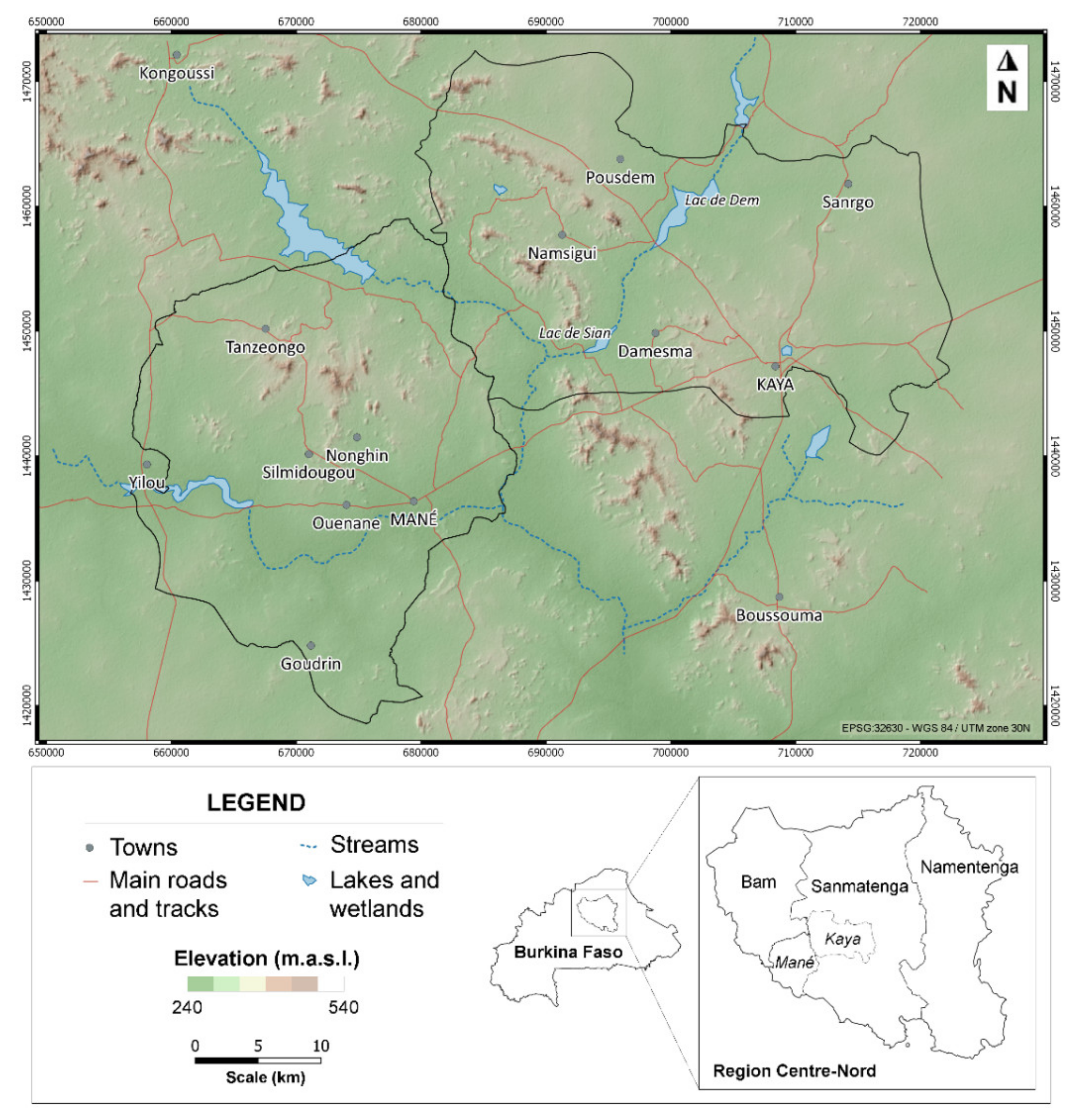
2.1. Study Area
2.2. Borehole Database
2.3. GIS Database
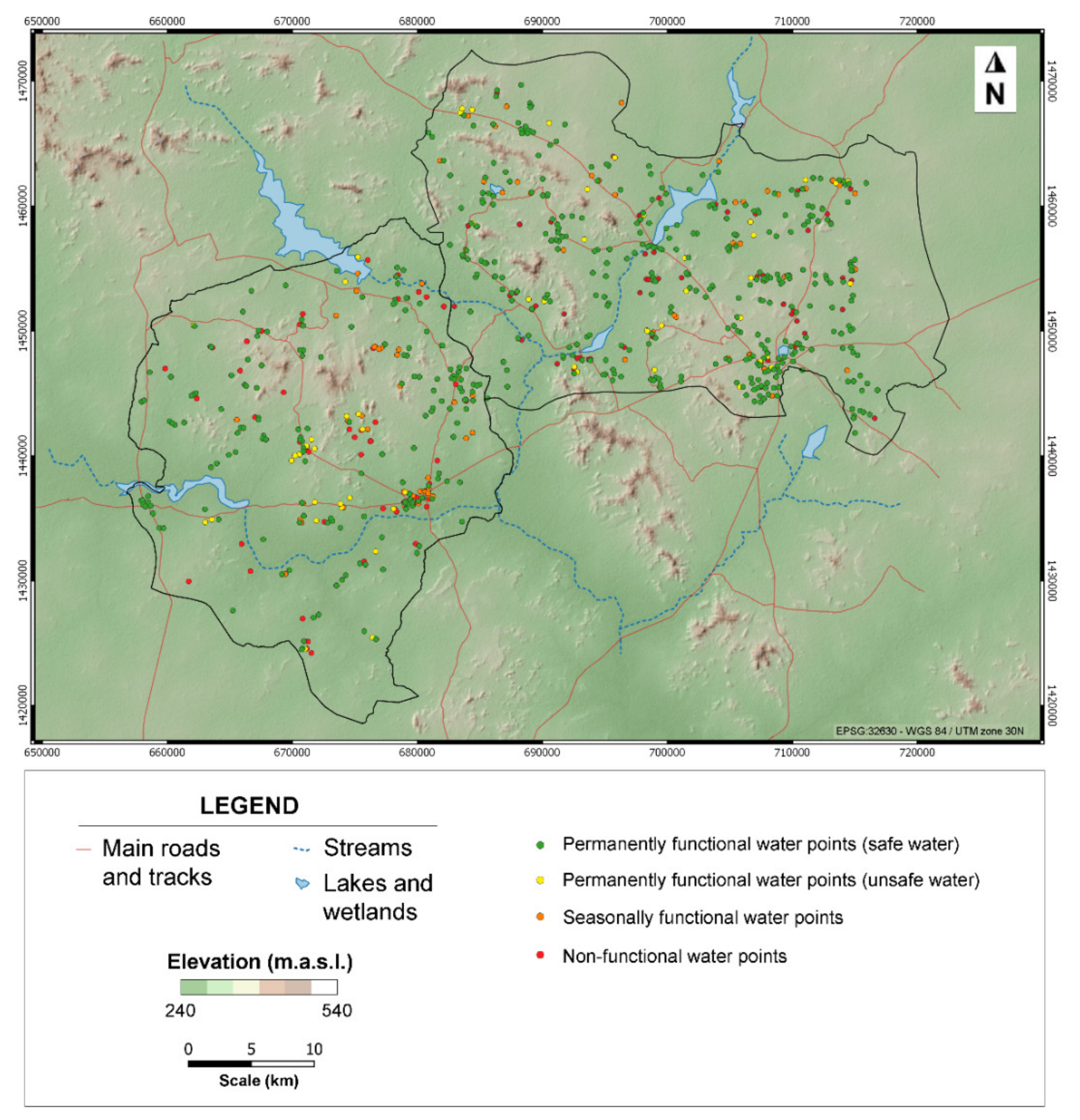
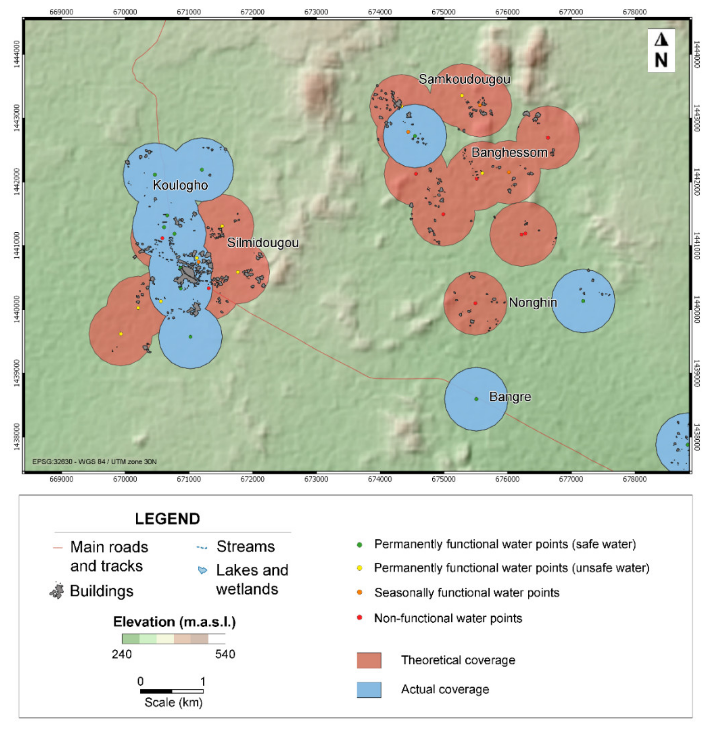
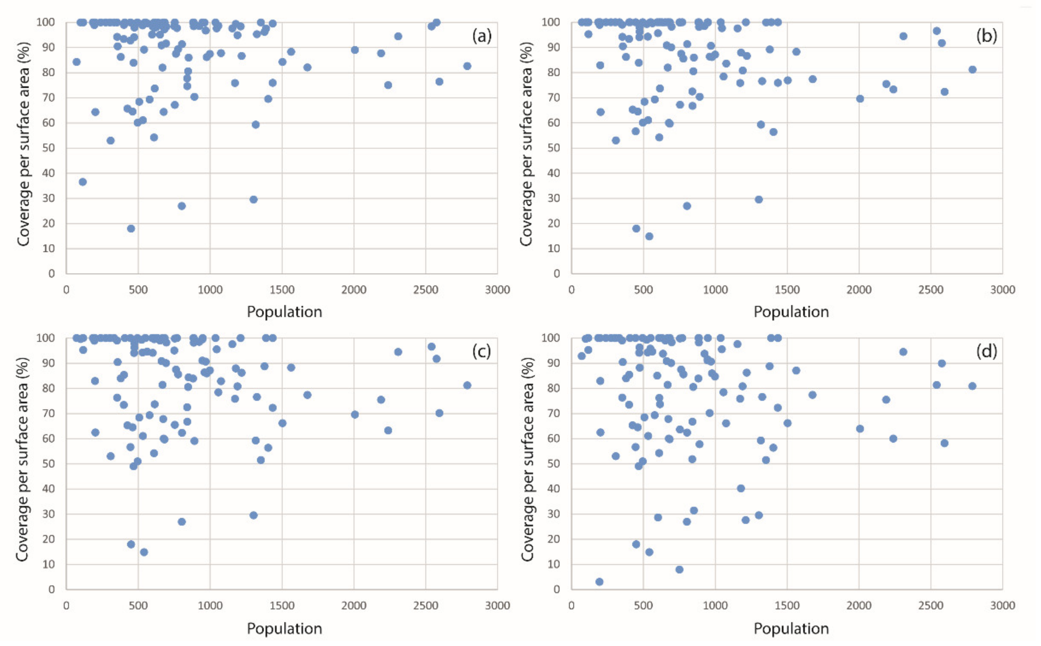
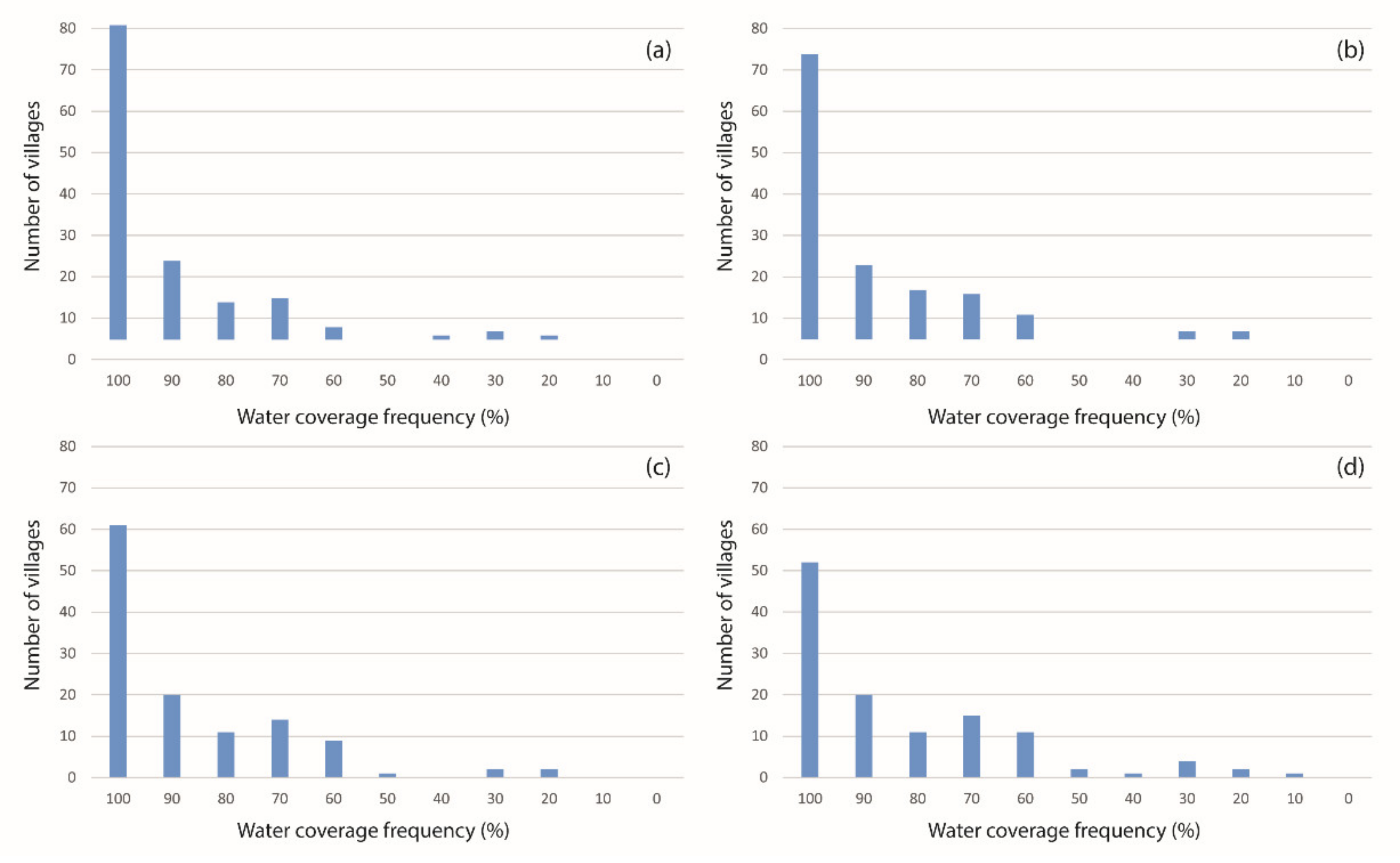
3. Results
4. Discussion
5. Conclusions
Author Contributions
Funding
Institutional Review Board Statement
Informed Consent Statement
Data Availability Statement
Acknowledgments
Conflicts of Interest
References
- United Nations. General Comment No. 15. The Right to Water; UN Committee on Economic, Social and Cultural Rights: Geneva, Switzerland, 2002. [Google Scholar]
- United Nations. Resolution A/RES/64/292; United Nations General Assembly: New York, NY, USA, 2010. [Google Scholar]
- Sphere. Humanitarian Charter and Minimum Standards in Humanitarian Response; Technical Guidelines, The Sphere Project; Sphere: London, UK, 2018; 3939p, ISBN 978-1-908176-00-4. [Google Scholar]
- UNICEF/WHO. Progress on Drinking Water and Sanitation: 2012 Update (Report); UNICEF and World Health Organization: New York, NY, USA, 2012; p. 66. [Google Scholar]
- Kayaga, S.; Fisher, J.; Franceys, R. Improved access to urban water services in Uganda. Proc. Inst. Civ. Eng. Munic. Eng. 2009, 162, 165–170. [Google Scholar] [CrossRef] [Green Version]
- UNICEF. The Rights to Safe Water and to Sanitation; UNICEF Current Issues 3:1-5; UNICEF: New York, NY, USA, 2014. [Google Scholar]
- Shaheed, A.; Orgill, J.; Montgomery, M.A.; Jeuland, M.A.; Brown, J. Why “improved” water sources are not always safe. Bull. World Health Organ. 2014, 92, 283–289. [Google Scholar] [CrossRef] [PubMed]
- Martínez-Santos, P. Does 91% of the world’s population really have “sustainable access to safe drinking water”? Int. J. Water Resour. Dev. 2017, 33, 514–533. [Google Scholar] [CrossRef]
- JMP. Safely Managed Drinking Water–Thematic Report on Drinking Water 2017; World Health Organization: Geneva, Switzerland, 2017; 52p. [Google Scholar]
- Bain, R.E.S.; Wright, J.A.; Christenson, E.; Bartram, J.K. Rural:urban inequalities in post 2015 targets and indicators for drinking-water. Sci. Total Environ. 2014, 490, 509–513. [Google Scholar] [CrossRef]
- JMP. Progress on Drinking Water, Sanitation and Hygiene; World Health Organization (WHO) and the United Nations Children’s Fund (UNICEF): Geneva, Switzerland, 2017. [Google Scholar]
- Foster, T. Predictors of sustainability for community-managed handpumps in Sub-SaharanAfrica: Evidence from Liberia, Sierra Leone, and Uganda. Environ. Sci. Technol. 2013, 47, 12037–12046. [Google Scholar] [CrossRef]
- Marks, S.J.; Clair-Caliot, G.; Taing, L.; Bamwenda, J.T.; Kanyesigye, C.; Rwendeire, N.E.; Kemerink-Seyoum, J.S.; Kansiime, F.; Batega, D.W.; Ferrero, G. Water supply and sanitation services in small towns in rural–urban transition zones: The case of Bushenyi-Ishaka Municipality, Uganda. Clean Water 2020, 3, 21. [Google Scholar] [CrossRef]
- Silva-Novoa, L.; Kemerink-Seyoum, J.; Zwarteveen, M. Water infrastructure always in-the-making: Distributing water and authority through the water supply network in Moamba, Mozambique. Water 2019, 11, 1926. [Google Scholar] [CrossRef] [Green Version]
- CILSS. Landscapes of West Africa–A Window on a Changing World; Comité Inter-Etats de Lutte Contre la Sécheresse Dans le Sahel, U.S. Geological Survey EROS: Garretson, SD, USA, 2016. [Google Scholar]
- Kaboré, P.N.; Ouedraogo, A.; Sanon, M.; Yaka, P.; Some, L. Caractérisation de la variabilité climatique dans la région du Centre-Nord du Burkina Faso entre 1961 et 2015. Climatologie 2017, 14, 82–95. [Google Scholar] [CrossRef] [Green Version]
- DEP. Carte Hydrogeologique du Burkina Faso; Feuille Ouagadougou. Echelle 1:50 000. Ministère de l’Eau and Directorat Général de la Coopération au Développement Pays Bas. 45p + Annexes and Maps; DEP: Ouagadougou, Burkina Faso, 1993; 45p. [Google Scholar]
- Chilton, P.J.; Foster, S.S.D. Hydrogeological characterisation and water-supply potential of basement aquifers in tropical Africa. Hydrogeol. J. 1995, 3, 36–49. [Google Scholar] [CrossRef]
- Foster, S. Hard-rock aquifers in tropical regions: Using science to inform development and management policy. Hydrogeol. J. 2012, 20, 659–672. [Google Scholar] [CrossRef]
- BGS. Groundwater Quality in Burkina Faso. British Geological Survey Fact Sheet; British Geological Survey: Nottingham, UK, 2002; 4p. [Google Scholar]
- Courtois, N.; Lachassagne, P.; Wyns, R.; Blanchin, R.; Bougaire, F.D.; Some, S.; Tapsoba, A. Large-Scale Mapping of Hard-Rock Aquifer. Properties Applied to Burkina Faso. Ground Water 2010, 48, 269–283. [Google Scholar] [CrossRef]
- MacDonald, A.M.; Davies, J. A Brief Review of Groundwater for Rural Water Supply in SUB-SAHARAN Africa; BGS Technical Report WC/00/33; British Geological Survey: Nottingham, UK, 2000. [Google Scholar]
- Foster, S.; Tuinhof, A.; Garduno, H. Groundwater Development in Sub-Saharan Africa: A Strategic Overview of Key Issues and Major Needs; GW-Mate Case Profile Collection No 15; The Word Bank: Washington, DC, USA, 2006. [Google Scholar]
- Koussoubé, Y.; Upton, K.; Ó Dochartaigh, B.É.; Bellwood-Howard, I. Africa Groundwater Atlas: Hydrogeology of Burkina Faso. British Geological Survey. 2018. Available online: http://earthwise.bgs.ac.uk/index.php/Hydrogeology_of_Burkina_Faso (accessed on 1 May 2021).
- Obuobie, E.; Barry, B. Burkina Faso. In Groundwater Availability and Use in Sub-Saharan Africa; A Review of Fifteen Countries; Pavelic, P., Ed.; International Water Management Institute: Colombo, Sri Lanka, 2012. [Google Scholar]
- Groen, J.; Schuchmann, J.B.; Geirnaert, W. The occurrence of high nitrate concentration in groundwater in villages in northwestern Burkina Faso. J. Afr. Earth Sci. 1988, 7, 999–1009. [Google Scholar] [CrossRef]
- Sako, A.; Sawadogo, A.; Yoni, M.; Nimi, M.; Zongo, O.; Bamba, O. Hydrogeochemical Characterization of Dug Well Water and Its Suitability for Domestic Water Supply in the Village of Passakongo, Dédougou municipality, Burkina Faso. Environ. Nat. Resour. Res. 2018, 8, 126–137. [Google Scholar] [CrossRef] [Green Version]
- Sako, A.; Yaro, J.M.; Bamba, O. Impacts of hydrogeochemical processes and anthropogenic activities on groundwater quality in the Upper Precambrian Sedimentary aquifer of Northwestern Burkina Faso. Appl. Water Sci. 2018, 8, 1–14. [Google Scholar] [CrossRef] [Green Version]
- ARGOSS. Guidelines for Assessing the Risk to Groundwater from On-Site Sanitation; British Geological Survey Commissioned Report CR/01/142; British Geological Survey: Nottingham, UK, 2001; 97p. [Google Scholar]
- Graham, J.P.; Polizzotto, M.L. Pit latrines and their impacts on groundwater quality: A systematic review. Environ. Health Perspect. 2013, 121, 521–530. [Google Scholar] [CrossRef] [Green Version]
- Martínez-Santos, P.; Martín-Loeches, M.; García-Castro, N.; Solera, D.; Díaz-Alcaide, S.; Montero, E.; García-Rincón, J. A survey of domestic wells and pit latrines in rural settlements of Mali: Implications of on-site sanitation on the quality of water supplies. Int. J. Hyg. Environ. Health 2017. [Google Scholar] [CrossRef]
- Smedley, P.L.; Knudsen, J.; Maiga, D. Arsenic in groundwater from mineralised Proterozoic basement rocks of Burkina Faso. Appl. Geochem. 2007, 22, 1074–1092. [Google Scholar] [CrossRef] [Green Version]
- DGEP. Inventaire National des Ouvrages AEP 2016; Communes Rurales de Mané et Kaya; Direction Générale de l’Eau Potable: Ouagadougou, Burkina Faso, 2016. [Google Scholar]
- Danert, K.; Ouedraogo, J.P.; Amadou, B.; Zombre, A. Good Practice for Borehole Drilling in Burkina Faso: 2017 Mission Report; Skat Foundation, Direction Générale des Ressources en Eau: Ouagadougou, Burkina Faso, 2019. [Google Scholar]
- Templeton, M.R.; Hammoud, A.S.; Butler, A.P.; Braun, L.; Foucher, J.A.; Grossman, J.; Boukari, M.; Faye, S.; Jourda, J.P. Nitrate pollution of groundwater by pit latrines in developing countries. Aims Environ. Sci. 2015, 2, 302–313. [Google Scholar] [CrossRef]
- WHO. Guidelines for Drinking-Water Quality: Fourth Edition Incorporating the First Addendum; World Health Organization: Geneva, Switzerland, 2017. [Google Scholar]
- Baumann, E. Water Lifting. Series of Manuals on Drinking Water Supply, No. 7; Swiss Centre for Development Cooperation in Technology and Management: St. Gallen, Switzerland, 2000. [Google Scholar]
- Oni, A.; Aizebeokhai, A.P. Impacts of Groundwater Development on Poverty Reduction and Alleviation in Nigeria. J. Inform. Math. Sci. 2017, 9, 455–484. [Google Scholar]
- Xu, Y.; Seward, P.; Gaye, C.; Lin, L.; Olago, D.O. Preface: Groundwater in Sub-Saharan Africa. Hydrogeol. J. 2019, 27, 815–822. [Google Scholar] [CrossRef] [Green Version]
- Foster, S.; Garduño, H. Groundwater-resource governance: Are governments and stakeholders responding to the challenge? Hydrogeol. J. 2013, 21, 317–320. [Google Scholar] [CrossRef]
- Grönwall, J.; Danert, K. Regarding Groundwater and Drinking Water Access through A Human Rights Lens: Self-Supply as A Norm. Water 2020, 12, 419. [Google Scholar] [CrossRef] [Green Version]
- Baumann, E. Performance Evaluation of Handpumps Used in UNICEF Projects; Technical Report; Swiss Centre for Development Cooperation in Technology and Management: St. Gallen, Switzerland, 1993; 46p. [Google Scholar]
- RWSN. Myths of the Rural Water Supply Sector. Rural Water Supply Network; Perspectives No. 4 (RWSN/A/2010/1); RWSN Executive Steering Committee: St. Gallen, Switzerland, 2010. [Google Scholar]
- Langenegger, O. Groundwater Quality and Handpump Corrosion in Africa; Technical Report; UNDP-World Bank Water and Sanitation Program: Washington, DC, USA, 1994; 143p. [Google Scholar]
- Martínez-Santos, P. Determinants for water consumption from improved sources in rural villages of southern Mali. Appl. Geogr. 2017, 85, 113–125. [Google Scholar] [CrossRef]
- Coulibaly, P.; Silga, M.; Mihin, J.P.; Sauret, E.S. Rapport de L’étude de la Stratégie de Suivi et D’évaluation des Ressources en eau; Partie 1: Rapport Diagnostic; Gouvernement du Burkina Faso: Ouagadougou, Burkina Faso, 2019; 240p.
- Bretzler, A.; Lalanne, F.; Nikiema, J.; Podgorski, J.; Pfenninger, N.; Berg, M.; Schirmer, M. Groundwater arsenic contamination in Burkina Faso, West Africa: Predicting and verifying regions at risk. Sci. Total Environ. 2017, 584, 958–970. [Google Scholar] [CrossRef] [PubMed]
- Bretzler, A.; Nikiema, J.; Lalanne, F.; Hoffmann, L.; Biswakarma, J.; Siebenaller, L.; Hug, S.J. Arsenic removal with zero-valent iron filters in Burkina Faso: Field and laboratory insights. Sci. Total Environ. 2020, 737, 139466. [Google Scholar] [CrossRef] [PubMed]
- Figoli, A.; Fuoco, I.; Apollaro, C.; Chabane, M.; Mancuso, R.; Gabriele, B.; Criscuoli, A. Arsenic-contaminated groundwaters remediation by nanofiltration. Sep. Purif. Technol. 2020, 238, 116461. [Google Scholar] [CrossRef]
- Sanou, Y.; Samuel, P.A.R.E. The Comparative study of adsorption capacity of two mixed materials for arsenic remediation in aqueous solutions. J. Environ. Treat. Tech. 2021, 9, 559–565. [Google Scholar]
- MEA. Programme National d’Approvisionnement en Eau Potable 2016–2030; MEA: Ouagadougou, Burkina Faso, 2017; 106p. [Google Scholar]


| Rural Commune | Water Points | Functional | Permanent | Safe Water |
|---|---|---|---|---|
| Mané | 286 (100%) | 233 (81%) | 192 (67%) | 169 (59%) |
| Kaya | 484 (100%) | 430 (89%) | 381 (79%) | 348 (72%) |
| Total | 770 (100%) | 663 (86%) | 573 (74%) | 517 (67%) |
| Commune | Water Points | Functional | Permanent | Safe Water |
|---|---|---|---|---|
| Mané | 97.7% | 93.3% | 89.3% | 81.2% |
| Kaya | 80.2% | 78.6% | 77.0% | 75.1% |
| Total | 85.2% | 82.8% | 80.6% | 76.9% |
| Category/Service Level | At Least Basic | Limited | Unimproved | Surface Water |
|---|---|---|---|---|
| National | 54% | 22% | 22% | 2% |
| Rural | 43% | 24% | 30% | 3% |
| Urban | 79% | 16% | 4% | 1% |
Publisher’s Note: MDPI stays neutral with regard to jurisdictional claims in published maps and institutional affiliations. |
© 2021 by the authors. Licensee MDPI, Basel, Switzerland. This article is an open access article distributed under the terms and conditions of the Creative Commons Attribution (CC BY) license (https://creativecommons.org/licenses/by/4.0/).
Share and Cite
Díaz-Alcaide, S.; Sandwidi, W.J.-P.; Martínez-Santos, P.; Martín-Loeches, M.; Cáceres, J.L.; Seijas, N. Mapping Ground Water Access in Two Rural Communes of Burkina Faso. Water 2021, 13, 1356. https://0-doi-org.brum.beds.ac.uk/10.3390/w13101356
Díaz-Alcaide S, Sandwidi WJ-P, Martínez-Santos P, Martín-Loeches M, Cáceres JL, Seijas N. Mapping Ground Water Access in Two Rural Communes of Burkina Faso. Water. 2021; 13(10):1356. https://0-doi-org.brum.beds.ac.uk/10.3390/w13101356
Chicago/Turabian StyleDíaz-Alcaide, Silvia, Wennegouda Jean-Pierre Sandwidi, Pedro Martínez-Santos, Miguel Martín-Loeches, José Luis Cáceres, and Naomi Seijas. 2021. "Mapping Ground Water Access in Two Rural Communes of Burkina Faso" Water 13, no. 10: 1356. https://0-doi-org.brum.beds.ac.uk/10.3390/w13101356